Winter 2011 issue 18
|
|
|
- Megan Owen
- 5 years ago
- Views:
Transcription

1 Upstreampaddle Winter 2011 issue 18

2
 turn right into Waterfall Creek Road. It s one kilometre to Mt May picnic ground.")

3 Twenty four kilometres south of Boonah, on the Boonah-Rathdowney Road, Burnett Creek Road turns off west. Two and a half kilometres later, turn left into Newman Road, and the other side of the hill, (1.8km) turn right into Waterfall Creek Road. It s one kilometre to Mt May picnic ground. From Mt May (801m) there is a good lookout over Mt Barney National Park, and the Eagles Ridge approach line to Mt Barney. If you climb the Mt May northern peak by the north east ridge from the Mt May picnic ground, and cross to the southern peak, you can descend to the 4wd Waterfall Creek road, and follow the road down to your start point in a circle. The same circuit is more difficult to do in reverse, as the exit off the northern ridge (running east west) down the NE ridge to the picnic ground can be difficult to find. Mt May left: the rock pool and waterfall, Mt May picnic ground below: north east ridge approach behind, now a walk west along the barely visible track, to the northern summit Page 3 of 46


4 At the picnic ground the road crosses Waterfall Creek and becomes 4wd only, with zero traffic recommended after rain. One hundred metres upstream on the creek is a waterfall and rock pool. Looks nice but the water is befouled by cows in the upstream pastures. The north east summit track starts in the picnic ground, next to the rock slab immediately east of the creek. The track is heavily eroded, and often overgrown. May sure you pick up the track if it is lost in regrowth. Distances are not great, the map distance from the picnic ground to the ridge top is only one kilometre, but it is all uphill. Good bush navigation skills are needed, and long pants to save your legs as you push through regrowth. Ṫowards the top, after 400 metres elevation gain (1.5 to 2 hours) there is a rock step that is climbed just right of centre. Shortly after the track veers west and climbs to views of Mt Maroon to the east, about 6 kilometers distant. above: track imposed on satellite photo right: track start at the picnic ground Page 4 of 46

5 above: a view of Mt Maroon out to the east, once the north east ridge is climbed below: Maroon Dam is seen to the north from the northern summit of Mt May Page 5 of 46

6 above: from left to right - Isolated Peak (Eagles Ridge), North Barney, and West Barney as seen from the northern summit of Mt May. below: the cliffs on the southern side of the northern summit of Mt May must be negotiated to reach the saddle Page 6 of 46
7 From the top of the north east ridge, the track, often obscured, goes west towards the northern summit. Favour the northern side of the ridge. The track leads to the high point on the south west end of the ridge, Great views of Maroon Dam, and an unseen 100m cliff to your north west. You can make out the 4wd road you will be on in a hour, down below you. To get from the northern summit of Mt May to the southern, you will have to descend south to the saddle, and climb back up. Pick up the path from the highest point on the northern summit and move south west. Get the right track as there are extensive cliffs. The way down is a traverse across a rock step to broken ground, not a descent on the step. The saddle has a couple of pleasant flat areas. Cast slightly east to pick up the track to the southern summit, and climb a lower rock step, and then a lesser top step, to the southern summit There is a nice flat open area back east 20 metres along the ridge. The descent to the Waterfall Creek 4wd road is back out on the SW tip of the ridge. Take care on an immediate rock step, then follow the ridge down. The track will vanish on broken rock occasionally, but you maintain the same direction down. When the track makes level ground, then becomes 4wd, you are only minutes away Waterfall Creek Road, and the descent to the right. It is 3.25 kilometres back to the picnic ground, with some great views of the cliffs on Mt May above you. below: view of the cliifs on the west side of Mt May from waterfall Creek Road. The peak on the far right is the northern summit, the southern slightly higher summit is obscured.. Page 7 of 46


8 Page 8 of 46


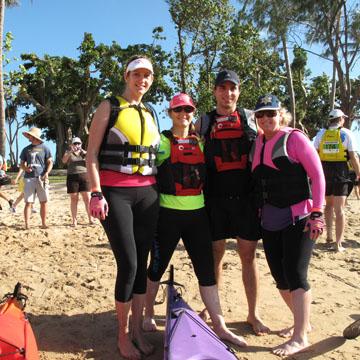
9 2011 Adventurethon Magnetic Island Never have I seen so many so tired! People everywhere around the Picnic Bay Hotel dragging their feet, speaking softly as they moved about. And this was the picture when competitors had completed their event even the team persons were smashed. After a damn hard preparation by Joel and Tamara during the previous week we came over to help with the final setup. The bright sandy beach and sunny weather and gusting winds promised a good day. However, the winds were to cause havoc later. The basic course was a paddle to and from West Point, followed by a mountain bike ride through Nelly Bay fire-trail to Horsehoe Bay then back to Picnic Bay THEN a run to and back from Nelly Bay via it s walking trail. Most of the off-road trails were very daunting as the Cyclone Yasi had caused a great deal of damage to the local vegetation. There were group events held that day, most running concurrently eg a duathlon (run/ride). Rather than describe them in detail it is easier to find this on the website Unfortunately I could not compete due to sickness so I resorted to my next favourite pastime photography. As I moved among the competitors I was impressed by the effort each person put into their respective event. This was only matched by the cheerful service provided by the staff of the Picnic Bay Hotel without whom it would have been much tougher. I believe that all who came along both as participants and spectators had a great time as the only grumbles I heard were about the course (we will fix that next year). On both days the volunteers worked tirelessly despite being subjected to some intense situations provided by the sun. Great job everyone!!!!! image top: rsea kayaks and skis pre race image centre: launching the rubber duckie image lower: pre race warm up Page 9 of 46


10 I would like to thank everyone who stayed behind and helped on Sunday for the final pack-up - your help was most appreciated. This was the first event of this kind ever held on Magnetic Island and as expected there were a few glitches but fortunately nothing serious occurred and there were no major injuries recorded. The most common problem was people who could not finish an event due to weather and track conditions this made the whole thing a real ADVENTURE sport. In my opinion, this weekend was a success not only for Joel and Tamara but all who participated and thank you to all who assisted in making it so. Hans-j Preuss image top: race start image centre: cranking up for the bike leg image lower: pre race warm up Page 10 of 46


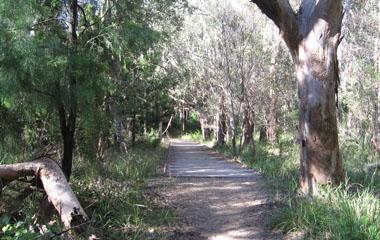
11 Coochiemudlo Coochiemudlo Island, in Moreton Bay, near Brisbane, less than one kilometre offshore from Victoria Point, is sandy on every side except the west, where mangroves grow on mudflats. Sea kayakers can go round the island in an hour or so, the distance to walk around the foreshore on the Coochie track is a little over 5 kilometres. The track cuts across the north western spit, past the golf greens to avoid the mud. A ferry service for passengers, and a barge for cars connects the island to mainland life. In summer during school holidays the island overflows with people, cars, and too much sun. At other times, especially during the week, life is slow. Page 11 of 46

12 Coochiemudlo Island has been called the closest sandy beach to Brisbane, and for that reason, the Life Savers hold Nipper training sessions on the summer beach near the ferry jetty. (photo right). If you are new to sea kayaking you can consider a paddle around Coochie as a training session too. Plan on launching from Victoria Point, near the beach just south of the vehicle ferry terminal, for the last two hours before the high tide. A wind usually comes up in Moreton Bay after 10:00 in the morning, so think about starting earlier. With a high tide and little wind, you can paddle around the island only a few metres out from the shore. At low tide there are extensive mudflats, particularly between the island and the mainland. (see photo below) The passenger ferry starts at 5:00 am, (pay on board) and the walk around the island is pleasant even in summer at that early hour. Keep a look out for the curlews who seem to like living in peoples front yards more than the foreshore forest. Page 12 of 46

13 Page 13 of 46


14 Map supplied by the Coochiemudlo Resort, courtesy of Mark Bowden. The only thing that isn t current is Matthew Flinders Café on the waterfront, as it closed some time ago. passenger ferry jetty, right, and the car ferry terminal, Victoria Point Page 14 of 46


15 upper four images: south western beach views age centre: launching the rubber duckie lower three images: eastern beach views Page 15 of 46


16 upper four images: island circuit walking trail views images: L. Steindlcentre: launching the rubber duckie lower three images: sunset beach views Page 16 of 46


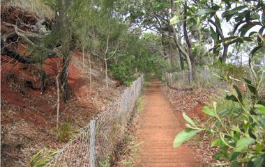
17 images: J A Seo upper image: mangroves on the northern shore above: southern shoreline image right: path to mangroves, northern shore Page 17 of 46
 the kayaker can be there in under an hour, and the crossing")
18 South Currigee - South Stradbroke Island South Currigee on South Stradbroke Island is an ideal destination for novice seakayakers, and siton-top paddlers. At little more than 3.5 to 4.0 kilometres paddle from the Ray Street boat ramp in Runaway Bay (depending on whether the line of approach is close to Wavebreak Island) the kayaker can be there in under an hour, and the crossing of the Broadwater can be cut to less than 300 metres of open water by island or sandbank hopping. The destination is an overnight campground (bookings essential ph: ) on the sheltered western side of South Stradbroke Island. Crossing the island is a good sandy foot track, some 400 metres to the ocean side. On the eastern beach, it is a 2.8 km walk (one way) up to the North Currigee beach track. The Broadwater can be a very busy and crowded waterway, with large fast moving boats that throw up a high wake. Because the waterway is also very shallow, these large fast movers will always be confined to a narrow channel along navigation markers. The kayaker, free to paddle shallow water, can pause on the edge of the shipping lane, then cut across when traffic eases. Page 18 of 46


19 The photograph above is an aerial of the Ray Street boat ramp at Runaway Bay. The ramp can be busy on the weekends, but kayakers will be able to launch off the sandy beach 100 metres west of the ramp, visible at the lower left in the photograph. Those vehicles parking spaces behind the beach are reserved for cars with boat trailers, so once you have unloaded your kayak, move down the street further. That high rise building throwing a shadow across the waterway in the photograph above, is one of a group of 5 buildings, that makes an exellent navigation marker, for the return trip. The photograph below is taken from South Currigee, and shows the same buildings. The highest one, to the foreground, left, is the aimimg point. Page 19 of 46


20 above: look for the playground equipment right above the high water line, to find the campground left: walk acrosss the island 400m to the sea Page 20 of 46


21 above: track to the beach, ocean side There is no drinking water available at South Currigee, take your own. If you use the campground facilities on a day use basis, there is a two dollar charge. If you are crossing the Broadwater near Wavebreak island, on your way north, it is recommended that you cross on a rising tide if you are not a stong paddler, as there can be a powerful current going out through the Seaway on a falling tide. left: ocean beach side, looking south to Surfers Paradise high rise towers, faintly visible through the sea spray, on a cloudy day. Page 21 of 46
22 above: this view from Tyalgum Ridge Resort, fourteen kilometres distant from Mt Warning, shows the western profile of Mt Warning, and immediately to its right, in the late afternoon sun, the sheer face of the Wollumbin Shield. The high point on the far right is Brummies Lookout, and the small high point on the same ridge, at the far left, is the North East Knoll shown on the accompanying map, and described in this article. Mt Warning NSW from the West Page 22 of 46

23 Mt Warning is an easily accessible mountain in the far north of NSW, near Murwillumbah, and is within reach of Brisbane residents, lying less than a two hours drive away. The mountain has a National Parks track to the top, and a recommended return time of 5 hours. The track is of a good standard, and the final 250 metres which is a rocky scramble, is made easier by a chain. At no time is there any exposure, and the climber is never near any scary cliffs. On top of the mountain are 360 degree views, an enclosure (60 x 40 metres), viewing platforms that ensure safety, and protect the summit vegetation from the thousands of yearly visitors. How many people see only cloud and mist from the top of this rain forest clad mountain is anyone s guess, but a raincoat is a necessary item in your daypack, and a couple of litres of water. The mountain top is a cloud catcher, and often the peak has a white cloudy cap when the rest of the sky is clear. The peak is said to be the place where the rising sun in the east first touches mainland Australia, and some folk make the climb before dawn to see the sunrise. Cape Byron is visible 44 kilometres away on a clear day. The best views are in winter when the air is not full of heat haze and water vapour. To the north west is the rim wall of Lamington, O Reillys, and the Green Mountains. The walk to the top of Mt Warning is under a rainforest canopy, and you see very little of the mountain s cliffs. One of the most impressive faces of Mt warning is the north west face, a 500 metre cliff, known as the Wollumbin Shield. This approach is visited only by a few rockclimbers, and bushwalkers. The road to the town of Tyalgum from Murwillumbah keeps close company with the Oxley River, and has occasional views of the north western face, some five kilometres away, but a circle of foothills around Mt Warning hides most of the view. The guide hereafter is on how to access a vantage point on the top of that circle of foothills to get a new and interesting view of Mt Warning. Most of the walking is on forestry roads that are currently closed to vehicle traffic (formerly 4wd only). Here described is access to Brummies Lookout. below: Brummies Road left, Condowie Road right Page 23 of 46


24 Two hundred metres east of Tyalgum is the E. Bartrim bridge over the Oxley River (launch point for grade 2 whitewater) and another 100 metres east is Swifts Road. The road is sealed. One and a quarter kilometres uphill the road branches, and the approach road continues as Brummies Road. We are heading towards Brummies Lookout. The sealed section of the road ends at two kms from the start back at Tyalgum Road, and the road goes on for a total of 4.25 kms. At this point there is a house on the western side of the road, and the road becomes 4wd for the last 200m to a National Parks gate. As the NP gate has a NO VEHICLE ACCESS sign we go uphill on foot. After 600m, North Wollumbin Road goes east, but we take the right branching road and go 400m further to where Condowie Road branches right, and Brummies Road (our path) goes left. At about 2km from the gate you gain the ridge top, with obscured views of the massive Wollumbin Shield cliff face out to the south east. The road follows the ridge south west, and even descends a little. At about 2.8km from the NP gate the landform on the eastern side of the road becomes a high earthern bank, and a series of wooden retainer steps up the bank can be discerned. left: NP locked gate Brummies Road left: The North Wollumbin road turnoff Page 24 of 46

25 above: this view of Mt Warning from near the North East Knoll shows the Wollumbin Shield, too much obscured by the rainforest canopy. Hopefully the view from the knoll, when finally navigated to, will have less trees overhead Go up these and on the ridge crest thirty metres in, turn right and move south west, slowly climbing. The thick overhead rainforest vegetation clears after 150m along the ridge crest, and grasstrees, long grass, and a few rocky outcrops are passed. At 3.2 km from the gate, the highest point is reached, with views of Mt Warning, and an awareness that there is a very vertical drop eastwards. This is Brummies Lookout. The view of Wollumbin Shield from Brummies Lookout is almost obscured as the walker is due west, though occasional views are seen after the walker emerges from the overhead rainforest canopy. The walker seeking a good view will have to go east along Tyalgum Ridge to Caldera Road, and the outcrop at its eastern end, the second vantage point. As access to that north eastern knoll is at the end of roads that are heavily overgrown, and the views from the ridge approach to it are limited by a heavy rainforest canopy, a good photograph from that vantage point will have to be considered a work in progress. Page 25 of 46
 vine.")
26 above: this view of Mt Warning from Brummies Lookout shows the gorge west of the mountain, but little view of the Wollumbin Shield. The old forestry roads have proven to be much overgrown with lantana, and the walk along the ridge to the North East Knoll is proving to be an encounter with a lot of Wait-a-While (Hairy Mary) vine. below: difficult photography conditions under the rainforest canopy, and the occasional patch of thorny regrowth to bypass. Page 26 of 46

27 Upstreampaddle Winter 2011 issue 18 Page 27 of 46

28 Dare2Dream H-j Preuss See you next time and thanks for a great time! Were my last words just after 4pm Wednesday 20th April. Or at least I thought that I would be going home to Townsville. Going back in time I had been asked to assist with a canoeing/raft building program at Tinaroo Dam. The students were all Naval Cadets ranging from 15 to 18 years old. And because of the excellent trainers provided I not only learnt a great deal but it was an enjoyable time. But, as with all good things it was time to return home. So I thought until a phone call changed my plans dramatically. I was asked if I would act as a Guide for a group of indigenous students. The plan was 4 days on - 1 day off then, 4 on again. As I had no firm plans over Easter I met with James and when everything was fully explained I agreed to do this. Now, at 4.15pm, I headed off to find the new campsite and meet with all the people concerned. At my new lodgings I met with Martin (CEO), Mac the CSM, Elgan, Shane, Trang, Adrian, Sam, Tully, Miss Peggy and Uncle Paul. All were part of the team looking after the students. After tea I was introduced to the students. Once I had an overview of the next days I found a spot for my swag then relaxed for the evening. Early the next day the first group and I headed over to a Rec Centre to obtain the canoes and all the necessary equipment. Once collected I took everyone and their craft to the water s edge. We went through all the safety drills and I must say the capsize drills were done very well despite some initial mis-givings. As part of the capsize drill no warning was given prior to the actual tip-over. By the amount of laughter from the students there were no signs of distress or anger. Before bringing our boats back to original campsite I let the students practice paddle strokes and having them spin their craft around. Then off to our home. editor s note:i had an from Hans about his Tinaroo Dam boot camp program, to quote My task was to take them camping/paddling around the Dam. It is run by retired military personnel and as an example of discipline any swearing or misbehaviour is INSTANTLY punished by a penalty of 20 pushups etc - Sadly, I too, trangressed and collected nearly 500 pushups. Page 28 of 46


29 above: program start first morning below: waterproofing backpacks Page 29 of 46

 had us paddling (a little further each day) until by the final day all students were capable of easily paddling 12 kms to return home.")
30 The next morning Mac (CSM) demonstrated how to correctly pack a backpack so all necessary items were waterproofed. Once he was satisfied that all had packed the right way we loaded our craft and were on our way. At this point I should point out that I was in a single kayak so I could move around between craft. This with having the patrol leaders leading the way and watching the tail end I could quickly get to any craft or persons if necessary. This worked very well. The next 3 days (of fine weather) had us paddling (a little further each day) until by the final day all students were capable of easily paddling 12 kms to return home. During this time it should be noted that as there were 2 persons to a boat that teamwork quickly developed. A bond also developed between all members as they were all facing the same issues together trust came very quickly. This was of great benefit whenever we camped for the night as all pulled together to make sure no-one felt left out in any way. The return paddle home was amazing as the group voted to push 6+ kms before stopping for a meal break then after food they absolutely smashed the last 3 kms. This was a fantastic effort considering the size and weight of their fully loaded canoes. A well deserved rest awaited them when they finally landed. Their huge smiles made my day complete!!! Anzac Day, complete with a gunfire breakfast, in the bush conducted by this group was one of the most moving I have ever shared. The respect and dignity shown would have made every Serviceman and woman very proud. After breakfast Mac again demonstrated how to correctly pack a backpack so all necessary items were waterproofed. Once he was satisfied that all had packed the right way we loaded our craft and were on our way. As we moved put the weather kept smiling on us, but, I had seen the fast high clouds and knew that rain was coming. On our first stop we were saddened by the sight of a large dead barramundi dumped and hidden in the grass. This fish would have fed us all for 2 days had it not been left to rot. Some people!!!! Page 30 of 46


31 top left: campsite top right: evening middle left: waterproofed pack test middle right: group photo lower left: capsize drill lower right: barra for tea Page 31 of 46

32 During the next 4 days we moved from camp spot to camp spot with Adrian (our Chef) bringing the food each lunch time along with other supplies. One stop was a Tobacco Hill and the owner Matt and his brother very kindly had cut the long grass to improve our campsite thank you guys. Again, I kept to my plans of increasing paddling distances each day. There were mandatory water stops to ensure noone de-hydrated, even on the rainy days. Remember the rain, yep, it came and STAYED for 3 days. Nothing seemed to dampen the students enthusiasm including the strong headwind which with the rain made paddling hard work. Putting up tents in the rain also failed to affect them they kept laughing and joking all the time. This group bonded much quicker and more strongly. I wonder if the trying conditions were responsible?? No matter - the teamwork and friendship grew steadily. The return journey needs a little mention. Again, our first leg home was 6+ kms to Tobacco Hill with a 3 km finishing distance. Here, initiative was clearly demonstrated by 2 canoe teams. They had worked out their line to shore then positioned their craft to take full advantage of the wind. They did not have to paddle more than 50 metres as they neared the opposite shoreline. After a short break we all paddled into the lagoon from where we had departed 4 days ago. Then the obligatory group photos were taken, all craft unloaded and they had done it. Great bunch of people!!!! Both groups had never paddled a canoe of this type or for the distances involved. I felt that as people they grew and had learnt a lot about each other and themselves. I believe that I also, have learnt a lot from sharing this awesome experience with them. To all who were involved in this event I thank you ALL. Page 32 of 46


33 Exploring Pindari Dam Northern Tableland, NSW top: distant view of the dam spillway lower: dam view, and a one kilometre walk to the spillway Page 33 of 46


34 Exploring Pindari Dam The population in southern Queensland and northern NSW is centred on the coast (Sunshine Coast, Gold Coast, Brisbane, Tweed Heads) and for them, Pindari Dam is not only a long way away inland, it is also probably off the map. Not only is it over five hours drive from Brisbane to Pindari Dam, but it is off any major highway system. The most direct way there is to follow the New England Highway south from Warwick, down through Stanthorpe, Wallangara, and Tenterfield to Deepwater, then go west through Emmaville. This way involves over 50 kilometres of unsealed dirt road, from Emmaville to Wells Crossing Road, and across to the Ashford Bukulla Road before getting back on sealed bitumen. It is possible to stay on sealed roads all the way to Pindari Dam, either going west from Warwick towards Goondiwindi, then south through Texas and Bonshaw, or west from Tenterfield on the Bruxner Highway almost to Bonshaw, then south to Ashford. I had been on the northern edge of this country some summer months previously, when I drove on dirt roads to Nundubbermere Falls, in the northern edge of Sundown National Park, west of Stanthorpe. That journey had been only ten kilometres on dirt on Nundubbermere Road, and four more down Falls Road to the waterfall on the Queensland Severn River. This time, in dry late Autumn weather, I drove another thirty four kilometres past Falls Road, around the borders of Sundown National Park to Mingoola, near where the Queensland Severn makes its southern exit from Sundown National Park. The road from Stanthorpe to Texas would have taken me there for the same distance on sealed roads, but that road keeps to the valleys, and I wanted the high road, to see the quilt of golden hills that reach from far horizon to horizon. Eventually I crossed the Queensland Severn River, and the Mole River. As the road to Bonshaw kept pace with the Severn, I could see the massive floodwaters from the summer of had broken all the river bank trees. Five kilometres short of Ashford, I turned towards Emmaville, and twelve kilometres east turned south onto a dirt road again, down to Wells Crossing. It is only ten kilometres to the NSW Severn River (totally different to the Queensland river) and Wells Crossing. Pindari Dam is a short seventeen kilometres distant to the east on the sealed Ashford Bukulla Road that runs by the southern side of the Wells Crossing bridge. After the wide open landscape for hundreds of kilometres, the camping spaces at Pindari Dam seemed too small, crowded too close to neighbours. The camping area at Wells Crossing was only a short distance way, and seemed preferable. below left: upstream view Wells Crossing bridge note the informal camp ground on the right bank below right: downstream view Wells Crossing bridge Page 34 of 46


35 Local information about the dam was that the wind could make conditions decidedly testing. Waves to over one metre would make the lake unsuitable for canoes, and a head wind would make a journey trying. On the day I was there, the dam surface was mirror like. A couple of powered boats carved across the still water. The water felt icy in the noonday sun. The same rainfall that made floodwaters carve through river bank trees on the Queensland Severn River, had filled the dam, and a boater assured me that the bluff I paused under was a two hundred metres walk from the waters edge six months previously. Now I could touch the cliffs above, without getting from the boat. The Severn River Nature Reserve covers the southern side of the river for about ten kilometres up from where the river flows into the dam, and also covers the upstream dam foreshore on the southern side. Elsewhere, the northern foreshore of the dam is privately owned. On the dam, a walk west on top of the wall to view the spillway is over a kilometre long. Before the heavy rains last year, the distance for a paddle up the dam to meet the incoming Severn River was about 10 kilometres, (Apple Tree Waterhole) but it is now more like 12.5 km (Eight Mile Falls). While the canoe paddle from below the dam to Wells Crossing was locally recommended, (14.5km) access was closed below the dam. It may be possible to put in at a road crossing 7.5 km upstream from Wells Crossing. It definitely is possible to paddle downstream from the Wells Crossing bridge, either a short 5.5 km paddle on grade one water to the Beaumont Road crossing on the Severn (3.2km out of Ashford on the Ashford Bukulla Road), or a longer 14km paddle to the Inverell Bonshaw Road. The area you are traveling into is sheep country. There has been no large population growth here on the back of a mineral resources boom, or tourism sponsored growth. So the country has largely stayed the way it was some half a century ago, and more. The attraction of paddling a canoe on Pindari Dam is matched by the majestic beauty of the western landscape. Brown, gold, and beige coloured countryside, with a scattering of open forest, under wide blue skies. below left: picnic area, Pindari Dam campground below right: Pindari Dam campground view green verge is floating weed Page 35 of 46


36 left: dam wall left: below the dam wall left: ramp view Page 36 of 46


37 As the canoeist travels further up the dam, away from the dam wall, towards the meeting place of the Severn River and the dam waters, some rocky bluffs overlooking the water are encountered. Page 37 of 46


38 above: Pindari Dam foreshore below: rocky buttress Page 38 of 46


39 Pindari lake views Page 39 of 46

40 Page 40 of 46


41 ELOUERA STATION top: the shearing shed lower: west of the homestead. Pindari Dam waters are two kilometres south west Page 41 of 46


42 Elouera Station was a 2,500 hectare property between the Pindari Dam s north western shoreline, and the Emmaville Road. The station has an historic shearing shed, but the property, which once carried 1,000 head, has not run sheep since The shed has not sheared sheep since about 2005, and the shearing machinery had been mostly removed. What remains is a fine example of a leather belt driven shaft, that powered four shearing stands. The power take-off was a simple but efficient revolving metal disc on the shaft, that actuated the shears when a small leather wheel was rotated by contact with the disc. Of interest is the sorting table (image right) and classing stalls with native timber slats. The wool press is hand cranked. Page 42 of 46


43 the shearing shed Note the leather drive belt, far left, running down from the drive shaft to where the steam engine once was, and the more modern electric motor that replaced it. a chute to below, for the shorn sheep to exit the shed Page 43 of 46

44 drive shaft and power take off the shearing shed Note the leather drive belt, far left, running down from the drive shaft to where the steam engine once was, and the more modern electric motor that replaced it. power take off fitting Page 44 of 46

45 wool press the shearing shed Note the leather drive belt, far left, running down from the drive shaft to where the steam engine once was, and the more modern electric motor that replaced it. power take off fitting Page 45 of 46

46 wool press the shearing shed Note the leather drive belt, far left, running down from the drive shaft to where the steam engine once was, and the more modern electric motor that replaced it. power take off fitting Page 46 of 46
left: Coombe Island from Wheeler
 left: Coombe Island from Wheeler In 1770 Captain Cook named a group of islands, close to the north Queensland mainland, the Family Islands. The family consists of two larger islands, Dunk and Bedarra (Richards),
Exploring the Dumaresq River
 Exploring the Dumaresq River The Dumaresq River (dew merrick) lies on the western side of the Great Dividing Range, the continuous line of mountains that flanks the entire east coast of Australia. The
GOLDEN EARS PROVINCIAL PARK
 GOLDEN EARS PROVINCIAL PARK Trail Information as of October 10 th 2015 Do not underestimate the mountainous wilderness of Golden Ears Provincial Park. The combination of rugged terrain and rapidly changing
Erskine Creek via Pisgah Rock and Jack Evans
 Erskine Creek via Pisgah Rock and Jack Evans 4 hrs 30 mins 7.1 km Circuit Very experienced only 6 421m This walk visits some great lookouts and explores the lower section of Erskine Creek. Most of the
Kakadu Highlights No. 9: September 23 - October 6, 2018
 Kakadu Highlights No. 9: September 23 - October 6, 2018 Section 1: Barramundi Creek: September 23-26 We begin with a four to six hour, 350 kilometre drive from Darwin. The last 45 kilometres is on a 4WD
beach. Make the ford and follow the trail out to the junction with Red Creek Tr in an open grassy area.
 Description: This is a moderate to slightly strenuous 22.8 mile backpack (add 2.6 miles if you do the packless out and back to the Lion s Head) that will have you exploring nearly every thing that is The
Wicklow Mountains Path Survey
 Wicklow Mountains Path Survey Glenmacnass Tonelagee Start to Finish: O 114 030 to O 085 016 Altitude (lowest highest): 370m 817m Weather: Sunny day, hot Access: Military Road, Glenmacnass Surveyed by:
Location: Height: Access: Distance: Elevation: Season: Difficulty: Lat/Long: Directions:
 Upper Eagle Falls Upper Eagle Falls (~20 ft.) is a short hike up from the roadside at the Eagle Falls picnic area. It is very difficult to get a parking spot here during the day, so it is recommended to
6 DAYS MACHAME ROUTES ON KILIMANJARO
 6 DAYS MACHAME ROUTES ON KILIMANJARO Day 1: Moshi Machame camp In the morning, we depart from our base hotel at approximately 8:00 AM for the Machame village where you begin the trek. From the park entrance
WORDS BY LUKE ARNOLD, PHOTOGRAPHY BY MATT HAWKE
 Southern SECRETS The scenery, history and 4WDing of this lesser-known region of the Victorian High Country will blow you away WORDS BY LUKE ARNOLD, PHOTOGRAPHY BY MATT HAWKE 038 038-043 Sth Alpine.indd
Guthega to Mt Twynam. 2183m. 1583m. 6 hrs 45 mins 14.8 km Return. Experienced only. 913m
 Guthega to Mt Twynam 6 hrs 45 mins 14.8 km Return Experienced only 5 913m This walk starts from Guthega and makes its way along the Snowy River to the Illawong Lodge, via the Blue Cow Creek flying fox.
Queen Mary Falls Ride. 40ks
 Queen Mary Falls Ride 40ks The 70k riders had wheeled out of the park at around 10,00am but the 40k riders had another hour to sit around and soak up the day. While we were waiting for kick off some of
Mount Daly a Most Prominent Peak via South Ridge
 Mount Daly a Most Prominent Peak via South Ridge Difficulty: Class 3 Exposure: Exposed in places along the ridge Summit Elevation: 13,305 Elevation Gain: 4100 from trailhead; 1800 from Capitol Lake camp
Listing of Campsites on the Manigotagan River
 Listing of Campsites on the Manigotagan River This document lists and describes the campsites along the Manigotagan River between Highway #314 and the government dock in the community of Manigotagan. The
HIKING IN THE CANADIAN ROCKIES
 HIKING IN THE CANADIAN ROCKIES Distance Time Elevation y MORAINE LAKE TRAILS THE ROCKPILE 0.8 km (0.5 mi) 20 min 30 m (98 ft) Located adjacent to the Lodge, the short interpretive trail up the Rock Pile
King George Area: May 5-18, 2019
 King George Area: May 5-18, 2019 Section 1: Faraway Bay airstrip to Twin Falls: May 5-12 We fly to the Faraway Bay airstrip where we leave the food for the second section, don our packs and head toward
Androscoggin River Trail Access Sites. North Woods. 168 miles from its source at Lake Umbagog to Merrymeeting Bay
 Androscoggin River Trail Access Sites North Woods 168 miles from its source at Lake Umbagog to Merrymeeting Bay Trail Under Construction More than 40 Public Access Sites Available Androscoggin River Watershed
Split Point Lighthouse Aires Inlet
 www.greatoceanroad.vc Great Ocean Road Three Day Tour 2 Night Stay This three day trip of approximately 730 kilometre starts from Melbourne and provides a good overview of features along the Great Ocean
C E N T R A L C A T S K I L L S
 120 C E N T R A L C A T S K I L L S Central Catskills Once out of the southern parts of the Catskills, the Long Path enters the more well traveled and civilized regions. The trail joins the Devil s Path,
CRAZY HORSE TRAIL GUIDE
 CRAZY HORSE TRAIL GUIDE Abridged Version: July 2016 This is a short form of our interpretive trail guide for the Crazy Horse Trail. The full version of the guide has a more detailed description of the
Skiing and Snowshoes on Un-groomed Fernan Saddle Terrain
 Skiing and Snowshoes on Un-groomed Fernan Saddle Terrain Three ski or snowshoe routes are available from the Fernan Saddle Parking Lot which either do not cover routes ordinarily groomed for snow machine
Photo Credit: Banff Lake Louise Tourism / Paul Zizka Photography MOUNTAIN ADVENTURES
 Photo Credit: Banff Lake Louise Tourism / Paul Zizka Photography MOUNTAIN ADVENTURES MOUNTAIN ADVENTURE PROGRAM Operated by Fairmont Chateau Lake Louise Fairmont Chateau Lake Louise has a long and proud
middle left: Riversleigh fossils lower left: Constance Range images: Hj Preuss... Thx
 Upstreampaddle Summer 2008 18 middle left: Riversleigh fossils lower left: Constance Range images: Hj Preuss... Thx top right: road west of the Isa middle right: Constance Range lower right: rocky outcrop
Lake Wissota Access Locations within the LaFayette Township. By Chad Martin
 Lake Wissota Access Locations within the LaFayette Township By Chad Martin Anson/ Wissota Access Point # 1 Road: 195 th St. Associated Fire Numbers: 13294 Defining Characteristics: Forested from road
Difficult Run Stream Valley Park
 Difficult Run Stream Valley Park The more intense mountain bikers have known about for Difficult Run for some time. Equestrians have known it longer. Eight miles of unpaved trail, the Rails to River Trail
Merritts Traverse. 1928m
 Merritts Traverse 3 hrs Hard track 5.8 km Circuit 4 167m This walk starts with a scenic journey to the top of the hill on the chairlift. Starting along Merritts Nature walk, this walk soon detours down
Charnley Explorer June 24 - July 15, 2018 Bachsten Creek and the Charnley River. Second draft: 14 November 2017
 Charnley Explorer June 24 - July 15, 2018 Bachsten Creek and the Charnley River. Second draft: 14 November 2017 The best part of the original section one is now part of out Gibb Road Gorges trip. The dates
Hiking Las Vegas.com
 Hike: Mt. Wilson via First Creek Canyon route Trailhead: First Creek marked Distance: 10 miles up and back Elevation gain: 3,400 feet Elevation of Peak: 7,070 feet Time: 7 to 9 hours (up and back) Difficulty:
Dadder Cave and Jack Evans track
 Dadder Cave and Jack Evans track 2 Days 10.3 km Circuit Very experienced only 535m This fairly short overnight walk is a great way to explore Erskine Creek. The walking along Erskine creek is mostly off
Note: Coordinates are provided as Universal Transverse Mercator UTM Zone U21, North American Datum 1983 (NAD 83).
.") Northern Traverse Route Description The Northern Traverse (formerly the North Rim Traverse) is an unmarked and rugged backcountry hiking route. It is known be a demanding hike, because of its terrain and
Northern Traverse Route Description The Northern Traverse (formerly the North Rim Traverse) is an unmarked and rugged backcountry hiking route. It is known be a demanding hike, because of its terrain and
Mt. Kilimanjaro Trek. WanderTours P.O. Box Seattle WA Itinerary dates: January 23 - February 1, 2019 Tour Escort: Beth Whitman
 WanderTours P.O. Box 16102 Seattle WA 98116 Mt. Kilimanjaro Trek Itinerary dates: January 23 - February 1, 2019 Tour Escort: Beth Whitman HIGHLIGHTS The six-day Machame Route to Uhuru Peak, considered
Great Ocean Road Two Day Tour
 www.greatoceanroad.vc Great Ocean Road Two Day Tour This two day trip of approximately 530 kilometre starts from Melbourne and provides a good overview of features along the Great Ocean Road between Anglesea
The Cleo s Bath North Side Hike
 The Cleo s Bath North Side Hike This hike is a cross-country hike from Pinecrest Lake to the north side of Cleo s Bath. It is quieter and much less crowded than the normal route, which goes up the south
Lake Baroon RECREATION GUIDE
 Lake Baroon RECREATION GUIDE seqwater.com.au About Lake Baroon OUR VISION To manage access to recreation opportunities while protecting natural resources and water quality. Lake Baroon, located between
Illawarra Escarpment State Conservation Area Walking Tracks
 Illawarra Escarpment State Conservation Area Walking Tracks NPWS Illawarra Area Office Ground Floor, Government Office Block 84 Crown Street Wollongong NSW 2500 02 4223 3000 (Mon-Fri) Royal National Park
THE THREE PEAKS OF TANZANIA
 THE THREE PEAKS OF TANZANIA Longido, Mt Meru, and Kilimanjaro in 13 days Day 1 Arrival Longido approx 10kms trekking FBA can arrange your flights to Nairobi or Kilimanjaro. If booking your own flights,
Self-Guided Walk Langdale Pikes. Start & Finish: NT car park (free to members) at Sticklebarn - on the right just beyond the New Dungeon Ghyll hotel.
 at Sticklebarn - on the right just beyond the New Dungeon Ghyll hotel.") Self-Guided Walk Langdale Pikes Key Information These mountains form a collection of spires and cliffs on the north side of Langdale. This walk visits four of the main tops Pavey Ark, Harrison Stickle,
Self-Guided Walk Langdale Pikes Key Information These mountains form a collection of spires and cliffs on the north side of Langdale. This walk visits four of the main tops Pavey Ark, Harrison Stickle,
Ombined End of Year Ride with Morning Tea at King River Cafe Oxley
 December, 2015 Western Australia Trip - October, 2015 Thanks to Kate and Graham s well named Ultimate home away from home, Graham s and my trip to the west was comfortable and well organised. We travelled
18Day Road Tour Christchurch to Christchurch
 18Day Road Tour Christchurch to Christchurch Route: Christchurch Farlie Lake Tekapo Twizel Wanaka Queenstown - Te Anau Milford Sound - Manapouri Queenstown Wanaka Haast Fox Glacier Franz Josef Hokitika
West Trails Trek Guide. Chief Pontiac Trail Credential Hikes
 West Trails Trek Guide Kensington Start Edition Chief Pontiac Trail Credential Hikes RDS.WTW.110609 WP# Dist. Accum. Dist. Accum. Feet Miles Meters Meters 1 0 0.0 0 0 2 410 0.1 125 125 3 164 0.1 150 275
Lincoln North Woodstock, New Hampshire Area Quick Guide
 Lincoln North Woodstock, New Hampshire Area Quick Guide Lincoln-Woodstock 2 towns in the heart of the White Mountain National Forest. Located at Exit 32 on I-93. 100 Miles from the Mass-NH Border. Supermarket
Mt Kuring-gai Track to Berowra station
 Mt Kuring-gai Track to Berowra station 4 hrs 15 mins 9.7 km One way Hard track 4 553m This walk explores three valleys, with great displays of wild flowers in spring, and some nice sandstone overhangs.
(west) onto Charleston Boulevard. Drive 16 miles on Charleston and turn right into Red Rock
 onto Charleston Boulevard. Drive 16 miles on Charleston and turn right into Red Rock") Hike: North Peak and Ice Box Overlook up and back Trailhead: 2.5 miles up the Rocky Gap Road not mark Distance: 5 miles round trip Elevation gain: 2,694 feet Elevation Peak: 7,094 feet Time: 3 to 5 hours
Hike: North Peak and Ice Box Overlook up and back Trailhead: 2.5 miles up the Rocky Gap Road not mark Distance: 5 miles round trip Elevation gain: 2,694 feet Elevation Peak: 7,094 feet Time: 3 to 5 hours
Camping (Primitive) Camping (RV) Electrical Potable Water Grill Established Fire Pit Picnic Table
 Camping (RV) Electrical Potable Water Grill Established Fire Pit Picnic Table") Alden - 9th Road River Mile 777 Map: 38.20833, -98.32031 Managing Agency: Kansas Department of Wildlife, Parks & Tourism Nearest Community: Alden, Rice County Kansas Developed Amenities Provided Parking
Alden - 9th Road River Mile 777 Map: 38.20833, -98.32031 Managing Agency: Kansas Department of Wildlife, Parks & Tourism Nearest Community: Alden, Rice County Kansas Developed Amenities Provided Parking
Berowra Waters to Cowan Station
 Berowra Waters to Cowan Station 3 hrs 30 mins 7.2 km One way Hard track 597m This is a hilly walk out of the beautiful Berowra Waters valley to Cowan Station. There are many wide views across Berowra Creek
Rogue Gorge (Mt. Stella) Roadless Area-- T30S R3E (primarily in portions of Sections 23, 26, 33, 34 & 35)
 Roadless Area-- T30S R3E (primarily in portions of Sections 23, 26, 33, 34 & 35)") Rogue Gorge (Mt. Stella) Roadless Area-- T30S R3E (primarily in portions of Sections 23, 26, 33, 34 & 35) Rogue River-Siskiyou National Forest--High Cascades Ranger District Upper, higher elevation trail
Rogue Gorge (Mt. Stella) Roadless Area-- T30S R3E (primarily in portions of Sections 23, 26, 33, 34 & 35) Rogue River-Siskiyou National Forest--High Cascades Ranger District Upper, higher elevation trail
Ewen Maddock Dam RECREATION GUIDE
 Ewen Maddock Dam RECREATION GUIDE seqwater.com.au About Ewen Maddock Dam OUR VISION To manage access to recreation opportunities while protecting natural resources and water quality. Ewen Maddock Dam,
ROBERTS CREEK PROVINCIAL PARK MASTER PLAN. November, 1981
 Ministry of Lands, Parks and Housing Parks and Outdoor Recreation Division Park Operations Branch North Vancouver, B. C. ROBERTS CREEK PROVINCIAL PARK MASTER PLAN November, 1981 Mr. G. Trachuk Director
Iceland Trip. Monday April 16, 2018
 Iceland Trip Monday April 16, 2018 My parents picked us up and we went to the airport. We stopped in Seattle for a few hours and ate McDonalds and killed time before flying to Iceland. On the way to Iceland,
Hiking Las Vegas.com
 Hike: Juniper Peak up and back Trailhead: Oak Creek Canyon marked Distance: 5.5 miles round trip Elevation gain: 2,200 feet Elevation peak: 6,109 feet Time: 4 to 5 hours - Up and back Difficulty: 3 Danger
Abbotts Falls Walking Track
 Abbotts Falls Walking Track 3 hrs 7.3 km Circuit Hard track 329m This circuit takes you through both dry and moist forest, using a combination of walking trails and wider tracks. The side trip to the dammed
Monday 9th January A day on the coast
 Monday 9th January 2017 - A day on the coast Today was allegedly a rest day after yesterday's big hike, and we certainly had a change of pace, but still did quite a lot of walking, albeit I was wearing
CRANBERRY. Introduction
 Introduction Introduction The Cranberry Boulders are a group of 60 problems set in a beautiful mossy forest above the Cranberry Creek. The boulders are located approximately 36km south of Revelstoke on
Nature Track. 900m. 789m. 2 hrs 3.1 km Circuit. Hard track 238m. Blue Mountains National Park
 Nature Track 2 hrs 3.1 km Circuit Hard track 238m Largely following the ridges around the top edge of Wentworth Falls, this track is incredibly beautiful. After taking in the great views at Edinburgh Castle
Black Hill Regional Park, Little Seneca Lake
 Black Hill Regional Park, ittle Seneca ake ittle Seneca ake, in Black Hill Regional Park, is a reservoir created after a previous drought struck the Washington area. The park is under Maryland-National
County Line trail - Miller Peak to Little Navaho
 County Line trail - Miller Peak to Little Navaho 7-17-2008 This hike features a portion of the County Line trail in the Teanaway that receives extremely little use despite offering a spectacular ridge-run
Trephina Gorge is one of the many sights to see along the way. Photo: Bob West.
 If you re heading from Mt Isa to Alice Springs on a road trip, you can maximise your trip to see the most that Australia has to offer by taking the scenic route down the Plenty highway. Here are all the
TREKKING EXPEDITION 4D CIRCUIT - MOUNTAINS FJORD
 TREKKING EXPEDITION 4D CIRCUIT - MOUNTAINS FJORD This 4 days trekking expedition begins in Resi fjord, and crosses to the Mountains fjord through a pass created by the strong erosion of a gone glacier.
Lake Kurwongbah RECREATION GUIDE
 Lake Kurwongbah RECREATION GUIDE seqwater.com.au OUR VISION To manage access to recreation opportunities while protecting natural resources and water quality. About Lake Kurwongbah Lake Kurwongbah is located
Leura Cascades to Gordon Falls Reserve
 Leura Cascades to Gordon Falls Reserve 1 hr 15 mins 1.8 km One way Moderate track 200m From Leura Park to Gordon Falls Park, this diverse walk offers fantastic views of the Jamison Valley, as well as two
Below is an example of a well laid-out template of a route card used by the Sionnach Team which is a good format to begin with.
 Route Card A route card is used as a navigational aid to hill walkers by setting out a step by step plan for an intended hike. It is good practice to make out a route card before every hike you or your
TUPPER DESIGNATED ACCESS ROUTE
 TUPPER DESIGNATED ACCESS ROUTE 1 FOR ACCESS/EGRESS TO CONNAUGHT, LOOKOUT, STONE ARCH, PORTAL PATHS AND TUPPER TRAVERSE EGRESS Length: 2.6km Vertical Gain: +162m / -83m (Values are for access. For egress,
Proposal to Redevelop Lower Kananaskis River-Barrier Lake. Bow Valley Provincial Park
 Frequently Asked Questions Proposal to Redevelop Lower Kananaskis River-Barrier Lake Bow Valley Provincial Park Frequently Asked Questions What has been decided? What are the details of the plan? What
Trip Report: Backpack to East Boulder Lake in California Trinity Alps, July 7-9, 2016
 Trip Report: Backpack to East Boulder Lake in California Trinity Alps, July 7-9, 2016 Trekkers: Richard Hales, Aleece Townsend, Carol Mockridge, Rosalie Rybka, Elisabeth Zinser Day 1: Richard and Aleece
MOUNT RINJANI VOLCANO TREKS
 3D 2N Crater Rim, Lake and Summit from Sembalun village This trek is suitable for beginner to experienced trekkers with good fitness. SCHEDULE Arrival day: Guests are picked up at their preferred location
CIEC 9 PEAKS AWARD SUPPLEMENT POSSIBLE ROUTES FOR THE 9 PEAKS AWARD TRIP
 CIEC 9 PEAKS AWARD SUPPLEMENT POSSIBLE ROUTES FOR THE 9 PEAKS AWARD TRIP As you plan your trip, be aware of 3 regulations in this wilderness: 1. Camp only in designated campsites. 2. No campfires allowed.
STEVE PRESCOTT FOUNDATION - Mt. Kilimanjaro Challenge
 STEVE PRESCOTT FOUNDATION - Mt. Kilimanjaro Challenge MACHAME ROUTE (DURATION: 8 DAYS including Crater Camp) ABOUT THE ROUTE: Many say this is the most beautiful route up Kilimanjaro; your efforts will
Route #2) Mt. Massive - Southwest Slopes
 Mt. Massive - Southwest Slopes") Route #2) Mt. Massive - Southwest Slopes Difficulty: Class 2 Ski: Advanced, D6 / R2 / III Exposure: Summit Elevation: Trailhead Elevation: Elevation Gain: Round-trip Length: Trailhead: County Sheriff:
Route #2) Mt. Massive - Southwest Slopes Difficulty: Class 2 Ski: Advanced, D6 / R2 / III Exposure: Summit Elevation: Trailhead Elevation: Elevation Gain: Round-trip Length: Trailhead: County Sheriff:
Mt. Thielsen Trip Report: April 29, 2012
 Mt. Thielsen Trip Report: April 29, 2012 Outing Organizer: Geoff Hance, with Brent McGregor Elevation Gain: 3,800 feet, over warming snow, with an exposed summit block Distance: About 9 miles round trip
GIFFORD PINCHOT NATIONAL FOREST
 GIFFORD PINCHOT NATIONAL FOREST 9341 Wright Meadow 93 Spencer Meadow Spencer Butte 4247' 30 30A 19 24 80 31C Lewis River Lower Falls 5 Quartz Creek 90 Taidnapam Falls Upper Falls 31 Spencer Peak 3861'
Camp Jack Wright PERMANENT ORIENTEERING COURSE (2004)
") Camp Jack Wright PERMANENT ORIENTEERING COURSE (2004) WHAT IS ORIENTEERING? The skill which enables a person to navigate with a map. In the competitive sport, the winner is the person who finishes in the
Camp Jack Wright PERMANENT ORIENTEERING COURSE (2004) WHAT IS ORIENTEERING? The skill which enables a person to navigate with a map. In the competitive sport, the winner is the person who finishes in the
TREK TO TABLE MOUNTAIN
 SOUTH AFRICA TREK CHALLENGING ABOUT THE CHALLENGE South Africa is a land of incredible contrast and beauty. It possesses a vast array of landscapes, from dense tropical bush to open desert. Our trek takes
Victoria Falls Lookout to Blue Gum Forest
 Victoria Falls Lookout to Blue Gum Forest 8 hrs Experienced only 13.8 km One way 5 112m This long day-walk follows a remote track down from Victoria Falls lookout, passing the waterfall, and into the Grose
Grizzly Peak A - East Ridge July 15, 2012
 Grizzly Peak A - East Ridge July 15, 2012 Difficulty: Difficult Class 2/Class 3 Upper Elevation: 13,995 feet Trailhead Elevation: 11,360 feet Elevation Gain: 3,000 feet Round-trip Length: 6.0 miles Trailhead:
Congewai Track Head (East) to Watagan Headquarters
 to Watagan Headquarters") Congewai Track Head (East) to Watagan Headquarters 7 hrs Hard track 17.2 km One way 4 973m This full day walk starts from the Congewai valley trackhead (east) and follows the Great North Walk up into the
Congewai Track Head (East) to Watagan Headquarters 7 hrs Hard track 17.2 km One way 4 973m This full day walk starts from the Congewai valley trackhead (east) and follows the Great North Walk up into the
Prince Regent National Park
 Prince Regent National Park 23 rd June- 14 th July 2019 Garimbu Creek, Moran and Roe River Area Notes written by Cassie Newnes This area has something for everyone, magnificent scenery, stunning waterfalls,
Photographing Upper Peninsula Waterfalls
 Photographing Upper Peninsula Waterfalls Tod Poirier Freelance Photographer Photography is one of my passions. The following spread showcases several Upper Peninsula waterfalls. At times a single drop
e-news TRACK REGENERATION WORK AT DINGO DELL, WEST OF SYDNEY.
 e-news TRACK REGENERATION WORK AT DINGO DELL, WEST OF SYDNEY. By the project coordinator, Matt Barnes, Public Relations Officer for the Land Rover Owners Club of Australia (Sydney Branch) Inc One of the
Podcast 31 - The Australian Alps - A Trip to Thredbo
 Podcast 31 - The Australian Alps - A Trip to Thredbo by Rob McCormack - Friday, January 03, 2014 http://slowenglish.info/?p=918 Learn English while learning about daily life in Australia, with Rob McCormack
Wentworth Pass. 893m. 535m. 4 hrs. Hard track 5.1 km Circuit. 692m
 Wentworth Pass 4 hrs Hard track 5.1 km Circuit 4 692m This walk offers a great way to explore the magical, upper section of the Valley of the Waters. The walk starts and finishes at Conservation Hut, which
TREK TO ANCIENT PETRA
 JORDAN TREK DEMANDING ABOUT THE CHALLENGE This challenging and adventurous trek takes us through unique landscapes in one of the friendliest countries in the world, ending at the impressive rock-hewn facades
Gibberagong Track. 169m
 Gibberagong Track 2 hrs 30 mins 6.5 km One way Hard track 4 180m Starting in suburban Wahroonga, this wellmaintained track follows Cockle Creek down to Bobbin Head in the Ku-ring-gai Chase National Park.
REPORT ON TRAIN DERAILMENT IN PITTSBURGH TUNNEL WEDNESDAY OCTOBER 10, 2001 By Thomas Edward Fox
 REPORT ON TRAIN DERAILMENT IN PITTSBURGH TUNNEL WEDNESDAY OCTOBER 10, 2001 By Thomas Edward Fox During the early morning hours of Wednesday, October 10, 2001, twelve hopper rail cars traveling on the Wheeling
Staples Lookout to Mt Wondabyne loop
 Staples Lookout to Mt Wondabyne loop 4 hrs 3 mins 1.8 km Circuit Hard track 337m This walk starts and finishes at Staples Lookout, on Woy Woy Rd. The walk follows sections of the Great North Walk around
Crystal Lake Area Trails
 Lake Area Trails Welcome to the Lake area of the Big Snowy Mountains! This island mountain range in central Montana features peaks reaching to 8,600 feet and long, high ridges from which vistas of the
Oman Trek Trek the dramatic and beautiful scenery of Oman
 Oman Trek Trek the dramatic and beautiful scenery of Oman Discover Oman on this breath taking 5 day challenge. The mountain ranges and deserts of Oman offer spectacular trekking, and enables you to experience
INCA TRAIL TO MACHU PICCHU
 PERU TREK TOUGH ABOUT THE CHALLENGE Machu Picchu is one of the most iconic sights in South America, and the culmination of our magnificent Inca Trail trek through the Peruvian Andes. Join us as we trek
Discover. Sledge Track Essence of Aotearoa
 Discover Sledge Track Essence of Aotearoa Discover Manawatu s timeless walkway adventure. Lying in the heart of the scenic Kahuterawa Valley, Sledge Track brings you face to face with the majesty of New
Russell s Jatbula Trail Maintenance Special: March - April 2013
 Russell s Jatbula Trail Maintenance Special: March - April 2013 After walking the Jatbula Trail just after Christmas, I began to wonder if there might be some way to give something back to the park. I
MOUNT RINJANI VOLCANO TREKS
 4D 3N Crater Rim, Lake, and Summit from Senaru village This trek is suitable for beginner trekkers with reasonable fitness. SCHEDULE Arrival day: Guests are picked up at their preferred location on Lombok
Guthega to Thredbo camping overnight at Wilkensons Creek
 Guthega to Thredbo camping overnight at Wilkensons Creek 2 Days Experienced only 25.8 km One way 5 1364m This great overnight walk explores the Kosciusko National Park between Guthega and Thredbo, visiting
Climbing Oak and Brushy Top Mountains
 Climbing Oak and Brushy Top Mountains Story and photographs by Vann Helms www.blueridgeimpressions.org Brushy Top Mountain- February 2, 2014 Brushy top summit After a January of record breaking cold weather,
Main Range Track - Loop from Charlotte Pass camping near Mt Townsend
 Main Range Track - Loop from Charlotte Pass camping near Mt Townsend 2 Days Experienced only 27.7 km Circuit 5 1260m This great overnight walk starts from Charlotte Pass and provides access to some of
Beautiful Walks from the Blue Ball Inn
 Walk No. 5 RIVER VALLEYS AND MOOR Countisbury, Watersmeet, Hillsford Bridge, Cheriton, Shilstone Hill, Rockford and Chiselcombe. 8.5 MILES APPROX. Walking time four and a half hours approx. OS 1;25,000
YMCA Calgary Camp Chief Hector YMCA Summer Camp. KANANASKIN 12Y-13Y 6-day or 13-day Hector Lodge. 6-DAY KANANASKIN 12Y-13Y Hector Lodge
 KANANASKIN 12Y-13Y 6-day or 13-day Hector Lodge Kananaskin camps offer a time for learning, making friends, working as a team, and having fun outdoors! Campers who are Kananaskin age may choose to come
Borneo. Adventure Mountains & Jungles
 Borneo Adventure Mountains & Jungles Itinerary 12 Days 11 Nights Borneo Adventure Malaysia Kota Kinabalu Kiulu Valley Kampung Sinasang Rungus Mahaba Nabalu Kundasang Mount Kinabalu National Park Kinabatangan
Lake Manchester RECREATION GUIDE. seqwater.com.au
 Lake Manchester RECREATION GUIDE seqwater.com.au About Lake Manchester OUR VISION To manage access to recreation opportunities while protecting natural resources and water quality. Lake Manchester is located
UTAH 2016 CANYONLANDS
 UTAH 2016 CANYONLANDS THE WHITE RIM TRAIL MAY 17, 2016 We left the cabin at 7:30 a.m. The goal was to get to Great Basin National Park that night. We took Highway 6 towards Tonopah and decided to go north
Mount Kilimanjaro Climbing via Marangu Route 6 day-itinerary
 Mount Kilimanjaro Climbing via Marangu Route 6 day-itinerary (For the 5-day route, simply exclude the additional acclimatisation day at Horombo hut - day 3 on the itinerary below.) Total hiking distance:
Instruction Manual. A step-by-step guide to building your own igloo. Andy Meldrum All rights are reserved.
 Instruction Manual A step-by-step guide to building your own igloo. Andy Meldrum 2007 1 Contents 1 Introduction 2 Get properly kitted up. 3 Choose and prepare your site. 4 Create the base. 5 Mark out the