CITY OF LAFAYETTE CALIFORNIA. Trails Implementation Plan
|
|
|
- Betty Evans
- 5 years ago
- Views:
Transcription
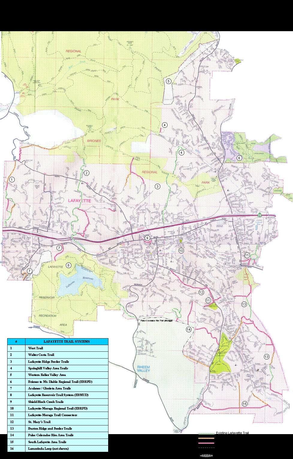
1 CITY OF LAFAYETTE CALIFORNIA s Implementation Plan Version Date: November 27, 20063, 2013
2 PURPOSE The Lafayette s Implementation Plan is a companion document to the Lafayette s Master Plan. The Implementation Plan is a working document intended to provide more current, and more fine-grained, detail than is included as part of the s Master Plan. The Implementation Plan includes detailed information on existing and proposed trail segments, including trail type, current status, and development plans. system descriptions included in the s Master Plan and indicated on the s Master Plan map provide general direction for the implementation of the trail system. However, alternative trail alignments and locations will be considered, and the specific trail route will be determined, at the time of implementation. routes will be based on community character, environmental conditions, and private property concerns, and additional trail segments may need to be dedicated or acquired in the future to enhance the overall effectiveness of the trail system. This document records the changing nature of the details of the trail segments based current conditions, planning and funding for trail acquisition and construction. s Implementation Plan 2
3 Types s are defined by the following three types: Type A Type B Type C Natural soft surface trails. These are the preferred type for community trails wherever conditions allow. Improved soft surface trail. These are preferred when wear and/or erosion problems discourage Type A surfaces. Hard surface trail. These routes are paved surfaces that complete linkages in the trail system. Type C trail segments include sidewalks, roads and driveways that were determined to be critical connections in the recreational trails system. Segment Details NAME 1 West connects neighborhoods across northwest Lafayette to the Briones Regional Park 1a Lorinda Lane A, C.35 from Los AribisArabis Road up Lorinda Lane to Camellia Lane. Easement also continues along Lorinda Lane fire road toward top of ridge. 1b 1c 1d Camellia Lane Hilltop Camellia Lane Scenic Area Camellia Lane to Canyon Road A, C.36 continuing along fire road over ridge and down to Camellia Lane A.20 through hillside scenic easement above Camellia Lane down to the road C.11 Short connector between end of Camellia LandLane and end of Canyon Road. Easement acquired and trail marked to end of easement. No easement acquired. This route preferred over 1c. no trail built. Less desirable alternative to 1b. 1e Canyon Road to Upper Happy Valley Road A.50 Segment from Canyon Road to Upper Happy Valley Road at Lafayette border with Orinda no trail built 1f Upper Happy Valley to Wellesley Court A.22 Segment from Upper Happy Valley to Wellesley Court, just south of the water tank. 1g Wellesley Court C.27 Segment starts at water tower and extends to endbeginning of WelleselyWellesley Court to join up with Briones trail. Easement acquired. No trail marked. s Implementation Plan 3
4 NAME 1h Wellesley Drive C.27 from Happy Valley Road along Wellesley Drive to the Russell Peak in Briones 2 Walter Costa A, C 2.17 connects from the base of Lafayette Reservoir (EBMUD Filter Plant) across to Happy Valley School 2a 2b Walter CostaHoward Hills Loop Happy Valley Connector and up to Lafayette Ridge (Briones) A, C.35 Neighborhood loop trail from Pine Lane to Quail Ridge A.65 Connector from Crestmont to Quail Ridge and then to Walter Costa 3 Lafayette Ridge Feeder s Feeder s to the Lafayette Ridge (Briones) 3a Rose Lane A.54 Segment leads from the end of Rose Lane up hillside totowards Lafayette Ridge (Briones) 3b St. Francis Ct A.65 Segment leads from the end of St. Francis Court up hillside to Lafayette Ridge (Briones) 3b3c Monticello Road C.85 Segment connects end of MontecelloMonticello Road to Rose Lane trail leading to Briones 3c3d 3d3e Jakovina (Sessions Rd) Elizabeth St (EBRPD) 4 Springhill Valley Area s but no trail built. No easement acquired, condition of approval for future development on Franklin Lane A 0.75 leads from Sierra Vista Way up Sessions Road to Lafayette Ridge (Briones) A.23 Connector trail to the Lafayette Ridge A Neighborhood trails in eastern Reliez Valley 4a4 Springhill ValleyJohn Kiefer 5 Briones Connectors A 0.75 leads from Springhill Valley at Goyak Drive up Leslyn Lane to Lafayette Ridge (Briones) C Connector s from Lafayette to Briones Regional Park trails 5a 4b5b Northern Lafayette Area of Interest SunsetSunrise (EBRPD) Area north of Echo Springs Rd and Reliez Valley Rd with potential connectors to Briones A.09 Section of the Sunrise in Briones that loops through Lafayette No easement acquired s Implementation Plan 4
5 55c NAME Western Reliez Valley Area of InterestPrado Creek 6 Briones to Mt. Diablo Regional (EBRPD) 6a Acalanes Ridge (Muir Heritage Land Trust) 7 Acalanes / Glorieta Area/Glorietta s CA.34 s from western Reliez Valley to BrionesConnector trail from creek north of Prado Way along west side of creek and up to EBRPD Sunrise A, C across easternnorthern Lafayette to Mt Diablo No easementspartial easement acquired, no trail built A.13 segment on Acalanes Ridge A, C s on Western side of the Lafayette Reservoir 7a Glorietta C.25 alongside Acalanes Rd, crossing the road just north of Glorietta Blvd and continuing to the Orinda border. 7b 7c Western Reservoir Area of Interest Reservoir Rim Connector A s from Acalanes / GlorietaGlorietta neighborhood connecting to Lafayette ReservourReservoir trail system. A.45 from western Mt. Diablo Blvd to Reservoir Rim but only lower portion of trail built 8 Lafayette Reservoir System (EBMUD) 9 Shield Block Creek sarea of Interest 10 Lafayette-Moraga Regional (EBRPD) 11 Lafayette-Moraga Connectors B, C EBMUD trails around the Lafayette Reservoir B Creekside trails through the Shield block in downtown Lafayette C 7.65 miles Regional trail from Olympic Blvd to Moraga Commons 0.62 s link Lafayette neighborhoods and the Lafayette Moraga Region No easement acquired 11a Schmidt Property A 0.12 This section connects the Lafayette- Moraga Regional near the corner of Pleasant Hill Rd and Olympic Rd to the Hidden Oaks Loop trail. 11b11 Hidden Oaks Loops B 0.50 Neighborhood loop trail through a scenic and trail easementeasements in the Hidden Oaks community. Also contains a trail easement connecting with the Saranap border. Easement - Developer building trail s Implementation Plan 5
6 11c11a NAME Buckeye Fields Connects Hidden Oaks s to Lafayette- Moraga Regional 12 St Mary s Road 12a Buckeye Fields 13 Burton RidgeCalaveras and Feeder s to Burton Ridge A Connector from Buckeye FieldsConnects the Hidden Oaks Loop trail to the Lafayette-Moraga Regional. B 1.00 between Stanley Middle School and Buckeye Fields to the west side and above St Mary s RdRoad. A.25 Connector from Buckeye Fields to Lafayette-Moraga Regional. from Olympic staging area to Las Trampas Regional Park, with feeder trails from the Burton Valley area. 13a Olympic Overlook A.59 This section of the trail climbs from the Olympic Staging Area to the top of Burton Ridge. 13b 13b13c Dianne Court to Olympic Overlook Lucas Ranch (Nazari)North Burton Ridge (Lindburg) A, C.42 From corner of Reliez Station Road and Dianne Court along Diablo Oaks Way to EBMUD tank and into the Olympic Overlook area. A.36 Section of Burton Ridge trail at north end of ridge. Includes feeder trail from Old Reliez Station Rd at Glenside intersection. 13c13d Liviakis A.18 Section of Burton Ridge trail south of Lucas Ranch segment. 13d13e Lindburg A.13 Section of Burton Ridge trail south of Liviakas segment. ; preliminary feasibility and engineering study completed on 746 St. Mary's Road in 2004No easement acquired, condition of approval for further development Land acquired and dedicated to EBRPD. Easement on paved surface, trail not marked Pending easement acquisition. Proposed development to be monitored.no Easement no trail built. no trail built. 13e13f 13f13g 13g13h Lindburg (formerly Strand) Lucas Ranch (Soldier Field (Fields - Woehrle) Burton Ridge to Rohrer Drive A.08 Section of Burton Ridge trail adjacent to Murray Lane north of Soldier Field segment A.72 Section of Burton Ridge trail at south end of ridge. Includes feeder trail along Lucas Drive. A.30 DescentThrough EBMUD water tank area and descent from Burton Ridge to Rohrer Drive 13h Rohrer Drive A 0.34 Neighborhood section at end of Rohrer Drive. Steep trail used primarily by Hanson's Equestrian Center at this time. Pending easement acquisition. Proposed development to be monitored. EBMUD realignment needed, no trail built. s Implementation Plan 6
7 13i 13j NAME Connector to Las TrampasMurray Lane MurrayMichael Lane to Calaveras 14 Palos ColoradosMoraga Rd to Reservoir Rim Area s 14a15 Silver Springs Loop 14b16 14c16a Reservoir to Moraga RdPalos Colorados Rim Area s Palos Colorados Rim (EBRPD trail in Moraga) AB.33 Continuation of trail from end of Rohrer Drive trail to Las TrampasConnector between the north end of the Lafayette Community Park and the Burton Ridge trail. BA.24 Connector between the northfrom end of the Lafayette Community Park and themurray Lane to top of Burton Ridge trail. A follows the Lafayette-Moraga border between the Lafayette Reservoir and the Lafayette-Moraga Region. Rd. A 0.78 Neighborhood loop trail through a scenic easement starting at end of Silver Springs Road. ConnectsCourt. (Planned connection to Palos Colorados Rim., when Rim completed.) A 0.62 EBMUD trail between follows the Lafayette Reservoir-Moraga border between Moraga Rd and the Palos Colorados RimLafayette-Moraga Regional. A 1.67 Ridgeline connecter trail along the Lafayette-Moraga border from Moraga Road to S. Lucille Lane. This trail is proposed on the Moraga side of the border. 14d16b Sweet Drive A.25 Feeder trail from the top of Sweet Drive to the Palos Colorados Rim (s) monitor connecting areas for acquisition to complete accessat 620 Michael Lane, No easement acquired on Lindburg property In progress 16c Lafayette Estates A.50 Connector trail from corner of Florence Dr and St. Mary s Rd up hillside to Palos Colorados Rim 14e16d S. Lucille Lane A 0.50 This section parallels S. Lucille Lane from St. Mary's Road to the edge of the Palos Colorado parcel. Easement - pending acquisition of 14c16a 17 Community Park s A, B s throughout the Lafayette Community Park s Implementation Plan 7
8 NAME 1518 South Lafayette Area s A s across southern portion of Lafayette with connectors from Burton Valley 18a Rohrer Drive A.34 Neighborhood section at end of Rohrer Drive. Steep trail used primarily by Hanson's Equestrian Center at this time. 18b Connector to Las Trampas A.62 Continuation of trail from end of Rohrer Drive trail to Las Trampas (s) 15a18c South Lafayette A across southern Lafayette border with Moraga from St. Mary s Road to Hunsacker Canyon Road. 15b18d Bradbury Drive A Neighborhood feeder trail from Bradbury Drive to Las Trampas. Connects to South Lafayette 15c18e Silverado Drive A Feeder trail towards Las Trampas. Connects to South Lafayette. 15d18f Read Drive A Connector from End of Read Drive south to Las Trampas. Connects to South Lafayette Lamorinda Loop C Lafayette portion of the Lamorinda Loop trail. monitor connecting areas for acquisition to complete access no trail developed Public right of ways designated s Implementation Plan 8
9 s Implementation Plan 9
CITY OF LAFAYETTE CALIFORNIA. Trails Implementation Plan
 CITY OF LFYETTE CLIFORNI PURPOSE The Lafayette is a companion document to the Lafayette Trails Master Plan. The Implementation Plan is a working document intended to provide more current, and more fine-grained,
Landscaping & Lighting Districts (LLDs) and Zones of Benefit (ZOB)
 and Zones of Benefit (ZOB)") Landscaping & Lighting Districts (LLDs) and Zones of Benefit (ZOB) Summary Alameda County/Contra Costa County LLD (ACC-1) known as the Two County LLD 1993/1996 Six Zones of Benefit 1994-2007 - Now the
Landscaping & Lighting Districts (LLDs) and Zones of Benefit (ZOB) Summary Alameda County/Contra Costa County LLD (ACC-1) known as the Two County LLD 1993/1996 Six Zones of Benefit 1994-2007 - Now the
Ardith Reservoir and Donald Pumping Plant. Figures 3.3-ARRES-1 to 3.3-ARRES-7
 Ardith Reservoir and Donald Pumping Plant Figures 3.3-ARRES-1 to 3.3-ARRES-7 feet Ivy Drive Moraga Way Leslee Lane Proposed Donald Pumping Plant A10 A12 A11 Proposed Ardith Reservoir Existing A2 Donald
Lafayette Water Treatment Plant. Lafayette Creek
 PINE LANE SR 24 EL NIDO NIDO RANCH RANCH WALTER COSTA TRAIL Lafayette Water Treatment Lafayette MT. DIABLO BOULEVARD Tributary Tributary This vegetation removal is associated with Lafayette Reclaimed Water
The Chu property is a 6.57 acre parcel located in the Town of Superior on the west side of McCaslin Boulevard. In 2014, the Town of Superior acquired
 1 The Chu property is a 6.57 acre parcel located in the Town of Superior on the west side of McCaslin Boulevard. In 2014, the Town of Superior acquired the Chu property for open space with a contribution
Natural Environment and Public Spaces
 CHAPTER 3 Natural Environment and Public Spaces acres for each 1,000 residents. The park standard in the subdivision ordinance established by the 1989 General Plan is 5 acres of parkland for every 1,000
Northeast Quadrant Distinctive Features
 NORTHEAST QUADRANT Northeast Quadrant Distinctive Features LAND USE The Northeast Quadrant includes all the area within the planning area that is east of Interstate 5 and to the north of State Route 44.
Wool Ranch 20 Acres 20 +/- acres Sunol, CA Alameda County
 Wool Ranch 20 Acres 20 +/- acres Sunol, CA Alameda County 707 Merchant Street Suite 100 Vacaville, CA 95688 707-455-4444 Office 707-455-0455 Fax californiaoutdoorproperties.com CalBRE# 01838294 Introduction
SMRPD Draft Master Plan of Trails, Adopted Oct. 14, 2004
 P.O. BOX 8, SILVERADO, CA 92676 SMRPD Draft Master Plan of Trails, Adopted Oct. 14, 2004 The Master Plan of Regional Riding and Hiking Trails Component is countywide in scope. It is a public trail system
Martinez General Plan 2035 White Paper TRAILS
 Martinez General Plan 2035 White Paper TRAILS November 2016 The Issue The draft Martinez General Plan 2035 and Draft Program Environmental Impact Report were released for public review on September 15,
S Central Coast Heritage Protection Act APRIL 21, 2016
 STATEMENT OF GLENN CASAMASSA ASSOCIATE DEPUTY CHIEF, NATIONAL FOREST SYSTEM U.S. FOREST SERVICE U.S. DEPARTMENT OF AGRICULTURE BEFORE THE UNITED STATES SENATE COMMITTEE ON ENERGY AND NATURAL RESOURCES
HUNTING PROPERTIES Bearpaw Trail Hand constructed with reclaimed timbers from a historic Stagestop.
 $4,500,000 #139289 428.0 AC $2,500,000 #138964 113.5 AC $24,9500,000 #137591 9,000.0 AC 8855 Bearpaw Trail Includes a 3 acre lake and borders Routt National Forest. 8925 Bearpaw Trail Hand constructed
City of Solvang SUNNY FIELDS SPUR TRAIL STUDY
 City of Solvang SUNNY FIELDS SPUR TRAIL STUDY project description The City of Solvang, in partnership with the County of Santa Barbara Public Works Department, is developing an alignment study for a proposed
EXECUTIVE SUMMARY PROGRAM DEVELOPMENT REPORT PURPOSE EXISTING SETTING EXPANDING PARKLAND
 EXECUTIVE SUMMARY PROGRAM DEVELOPMENT REPORT PURPOSE As the culmination of the first phase of the master planning process, this Program Development Report creates the framework to develop the Calero County
At the time, the portion of the line through Eagle County remains wholly under the ownership of Union Pacific Railroad (UP).
.") Chapter 5 The Railroad Corridor as a Trail Corridor The intent of this chapter is to identify how the rail corridor, if available for lease or purchase in all or part, could be incorporated into the core
Chapter 5 The Railroad Corridor as a Trail Corridor The intent of this chapter is to identify how the rail corridor, if available for lease or purchase in all or part, could be incorporated into the core
FEASIBILITY CRITERIA
 This chapter describes the methodology and criteria used to evaluate the feasibility of developing trails throughout the study areas. Land availability, habitat sensitivity, roadway crossings and on-street
LAS VARAS RANCH CA COASTAL TRAIL PROPOSED ALIGNMENT
 LAS VARAS RANCH CA COASTAL TRAIL PROPOSED ALIGNMENT Santa Barbara Trails Council * Prepared by Ray Ford February 1,2012 The following notes accompany the Santa Barbara Trails Council map for the Las Varas
Trail Phasing Plan. Note: Trails in the Clear Creek Canyon area (Segments will be finalized in the future to minimize wildlife impacts
 Note: Trails in the Clear Creek Canyon area (Segments 2 5 and a future JCOS connection) will be finalized in the future to minimize wildlife impacts Trail Phasing Plan P Parking 3 Easy Trail Intermediate
A CASE FOR COMPLETING THE JORDAN RIVER PARKWAY: A
 A CASE FOR COMPLETING THE JORDAN RIVER PARKWAY: A safe crossing at 9000 South and 850 West Proposed 9000 South Underpass Parkway Timeline Parkway, Trail, and Tourism Facts Blueprint Jordan River 1971 1973
Trail Assessment Report
 Trail Assessment Report Trail Options for the Bear Creek Canyon located in Pikes Peak Ranger District, Pike National Forest and on Colorado Springs Utility Lands Due to the presence of a unique species
TAYLOR CANYON RANCH COLORADO - ROUTT COUNTY - STEAMBOAT SPRINGS
 TAYLOR CANYON RANCH COLORADO - ROUTT COUNTY - STEAMBOAT SPRINGS Tucked up against the steep valley shaped by Mt. Pau and rising to the Routt National Forest, Taylor Canyon Ranch is an easily accessible,
Hiking California's Trinity Alps Wilderness: A Guide To The Area's Greatest Hiking Adventures (Regional Hiking Series) By Dennis Lewon READ ONLINE
 By Dennis Lewon READ ONLINE") Hiking California's Trinity Alps Wilderness: A Guide To The Area's Greatest Hiking Adventures (Regional Hiking Series) By Dennis Lewon READ ONLINE With over 600 miles of trails and 500000 acres of wilderness
Hiking California's Trinity Alps Wilderness: A Guide To The Area's Greatest Hiking Adventures (Regional Hiking Series) By Dennis Lewon READ ONLINE With over 600 miles of trails and 500000 acres of wilderness
NOTICE OF DESIGNATED POLLING PLACES FOR THE MAY 19, 2009 STATEWIDE SPECIAL ELECTION
 NOTICE OF DESIGNATED POLLING PLACES FOR THE MAY 19, 2009 STATEWIDE SPECIAL ELECTION NOTICE IS HEREBY GIVEN of designated polling places for the May 19, 2009 Statewide Special Election. You will find your
SEGMENT ASSESSMENT REPORT
 2017 SEGMENT ASSESSMENT REPORT SEGMENT 3: MT ROSE / TAHOE MEADOWS TO SPOONER SUMMIT REPORT SUMMARY This report is a compilation of information collected on the Tahoe Rim Trail during assessments performed
Chatsworth Branch Library Devonshire Street, Chatsworth, CA Thursday, November 16, :00-8:00 pm
 Chatsworth Branch Library 21052 Devonshire Street, Chatsworth, CA 91311 Thursday, November 16, 2017 6:00-8:00 pm Project Team County of Los Angeles Department of Parks and Recreation Kathline King Chief
Stevenson Ranch Library The Old Road, Stevenson Ranch, CA Thursday, November 9, :00-8:00 pm
 Stevenson Ranch Library 25950 The Old Road, Stevenson Ranch, CA 91381 Thursday, November 9, 2017 6:00-8:00 pm Project Team County of Los Angeles Department of Parks and Recreation Kathline King Chief of
Segment 2: La Crescent to Miller s Corner
 goal of the USFWS refuges is to conserve, protect and enhance fish, wildlife and plants and their habitats for the continuing benefit of the American people. Refuge lands are used largely for fishing,
NAVAJO COMMUNITY PLAN
 NAVAJO COMMUNITY PLAN Prepared by the NAVAJO COMMUNITY PLANNERS and THE CITY OF SAN DIEGO City of San Diego Planning Department 202 C Street, MS 4A San Diego, CA 92101 Printed on recycled paper. This information,
EXECUTIVE SUMMARY FALL Introduction. Findings
 EXECUTIVE SUMMARY FALL 2004 Introduction Trails are one of the most popular and highly desirable recreational resources in communities of all sizes throughout the country. In addition to providing a safe
CIEC 9 PEAKS AWARD SUPPLEMENT POSSIBLE ROUTES FOR THE 9 PEAKS AWARD TRIP
 CIEC 9 PEAKS AWARD SUPPLEMENT POSSIBLE ROUTES FOR THE 9 PEAKS AWARD TRIP As you plan your trip, be aware of 3 regulations in this wilderness: 1. Camp only in designated campsites. 2. No campfires allowed.
UMASS CROSS-COUNTRY Trails
 UMASS CROSS-COUNTRY Trails 1) EGG (43 min) (A) From Cage proceed to North Pleasant street (by campus pond). Make left and head toward LGRT and pass School of Education. Pass Puffton Apt complex (on left)
Sunrise Ranch 6890 acres, Jeff Davis County, Texas On the Fort Davis Scenic Loop
 Sunrise Ranch 6890 acres, Jeff Davis County, Texas On the Fort Davis Scenic Loop 432-386-2821 Cell 432-426-2024 Office james@kinglandwater.com King Land & Water LLC P.O. Box 109, 600 State Street, Fort
Potato Chip Grinder. Sheet1
 Potato Chip Grinder MILE DIRECTIONS FOR 0 START: Albertsons 5 Woodland Pkwy San Marcos, CA. (OPEN:00:00 CLOSE:+0:00) Obtain proof of start from local business with time & date stamp. Exit parking lot toward
Partners: Michigan California Timber Company Shasta-Trinity National Forest Pacific Crest Trail Association The Trust for Public Land
 Partners: Michigan California Timber Company Shasta-Trinity National Forest Pacific Crest Trail Association The Trust for Public Land Describe the project location, size, opportunities, and timing. Provide
Gardner: overview. Santa Fe, Oregon, and California National Historic Trails UNINCORPORATED JOHNSON COUNTY OLATHE UNINCORPORATED JOHNSON COUNTY
 Santa Fe, Oregon, and California ational Historic Trails : overview 99: p.134 100: p.135 GARDER JUCTIO 102: p.137 56: p.126 EDGERTO Burlington orthern Intermodal and Logistics 98: p.133 101: p.136 S Waverly
Southwest Quadrant Distinctive Features
 SOUTHWEST QUADRANT Southwest Quadrant Distinctive Features LAND USE The 31.17 square mile Southwest Quadrant includes all the area within the planning area west of I-5 and south of the Sacramento River.
BOND PROGRAMS PROJECTS SCHEDULE AND DELIVERY
 BOND PROGRAMS PROJECTS SCHEDULE AND DELIVERY Presented to the City Council By the City Manager s Office May 10, 2016 1 Topics Update on Projects From Previous Bond Programs Prior to 2014 2014 Bond Program
Piestewa Peak/Dreamy Draw Trail Guide
 Piestewa Peak/Dreamy Draw Trail Guide Trail #1A - Perl Charles Memorial Trail Length: 4.8 miles Elevation: 2,200 ft. - 1,340 ft. Difficulty: Moderate to difficult The Perl Charles trailhead is located
4. Improvement Plan Elements
 4. Improvement Plan Elements Detailed description of all elements Leigh Creekside Park Improvement Plan Preliminary Conceptual Time Zone Layout Caveat: in the following plans and descriptions, specific
PUBLIC INFORMATION SESSION #2
 Highway 16, Highway 779 to Kapasiwin Road, Planning Study PUBLIC INFORMATION SESSION #2 Wednesday June 20, 2012 4 to 8 pm HIGHWAY 16 Highway 779 to Kapasiwin Road Functional Planning Study Blueberry Community
COASTAL CONSERVANCY. Staff Recommendation December 2, 2004 COYOTE HELLYER COUNTY PARK BAY AREA RIDGE TRAIL
 COASTAL CONSERVANCY Staff Recommendation December 2, 2004 COYOTE HELLYER COUNTY PARK BAY AREA RIDGE TRAIL File No. 04-057 Project Manager: Amy Hutzel RECOMMENDED ACTION: Authorization to disburse up to
Chapter 2: Summary of Existing Open Space System
 Chapter 2: Summary of Existing Open Space System In 1976, the Wake County Board of Commissioners established the Wake County Parks and Recreation Department in order to provide park facilities and programs
BST Coalition Annual Report 2005
 BST Coalition Annual Report 2005 I. Introduction The Bonneville Shoreline Trail Coalition (Coalition) is an organization of entities, both citizen and governmental, representing the communities in Utah
Welcome to the Cross County Trail Public Input Session!
 Welcome to the Cross County Trail Public Input Session! Please sign in on the table below! What are we doing here? Camden County has proposed a bicycle and pedestrian trail spanning across the entire county.
Deschutes River Trail Action Plan
 Deschutes River Trail Action Plan for The Bend Metro Park and Recreation District The City of Bend The Bend Park and Recreation Foundation September 2002 Acknowledgements The project team would like to
5520 STEPHANIE STREET, LAS VEGAS >> ±36,019 SF OFFICE/WAREHOUSE/DISTRIBUTION, LAS VEGAS, NV 89122
 FOR SALE - FREE STANDING INDUSTRIAL BUILDING WITH LARGE FENCED YARD 5520 STEPHANIE STREET, >> ±36,019 SF /WAREHOUSE/DISTRIBUTION,, NV 89122 N DECATUR BLVD S DECATUR BLVD VALLEY VIEW ROAD SE N EASTERN AVE
Camp Geronimo Rainbow Trails
 Camp Geronimo Rainbow Trails With over 5,000 acres of surrounding national forest, the possibilities of getting out and seeing the wilderness are almost limitless. Camp Geronimo offers some of the greatest
Dear Councilman Reyes and Members of the PLUM Committee:
 CANYON BACK ALLIANCE A NON-PROFIT PUBLIC BENEFIT CORPORATION WWW.CANYONBACK.ORG E-MAIL: INFO@CANYONBACK.ORG March 20, 2006 Re: Final EIR No. ENV-1999-3251-EIR Project Title: Mountaingate Project, CD-11
TENNESSEE MOUNTAIN LIVING
 NOVEMBER 2016 Featuring Jasper Highlands TNLand.com END of the YEAR December 26th to Land Sale December 31st See back cover for more info... TENNESSEE MOUNTAIN LIVING JASPER HIGHLANDS - TENNESSEE'S MOST
Business Park. Amador Central. Offi ce / R&D Sites in Martell, CA FOR SALE & Build to Suit Opportunities DEVELOPMENT OPPORTUNITY. Blvd.
 DEVELOPMENT OPPORTUNITY Amador Central Business Park Offi ce / R&D Sites in Martell, CA FOR SALE & Build to Suit Opportunities 45 48 Locomoti ocomoti omo omo motive Ln Ln Ln Ln 47 46 44 35 Boxc xcar r
RECREATION AND RESORT PROJECTS
 RECREATION AND RESORT PROJECTS Coyote Moon Golf Clubhouse, Truckee, CA Dollar Point Pool and Tennis Club, Tahoe City, CA Donner Lake Boat Ramp, Truckee, CA Tahoe Swiss Village Beach and Shore Frontage,
June 22, Superintendent Jock Whitworth Zion National Park Springdale, UT Re: Wild and Scenic River Management Plans
 Nathan Fey Colorado Stewardship Director 1601 Longs Peak Avenue Longmont, Colorado 80501 nathan@americanwhitewater.org June 22, 2010 Superintendent Jock Whitworth Zion National Park Springdale, UT 84767-1099
COASTAL CONSERVANCY. Staff Recommendation March 17, 2011 EAST-SLOPE SONOMA MOUNTAIN RIDGE TRAIL PLANNING
 COASTAL CONSERVANCY Staff Recommendation March 17, 2011 EAST-SLOPE SONOMA MOUNTAIN RIDGE TRAIL PLANNING File No. 11-008-01 Project Manager: Sam Jenniches RECOMMENDED ACTION: Authorization to disburse up
LIHTC Properties in California's 7th District. (Ami Bera - D) LIHTC (1997 to 2016) Source: HUD LIHTC Through 2016
 LIHTC (1997 to 2016) Source: HUD LIHTC Through 2016") LIHTC Properties in California's 7th District LIHTC (1997 to 2016) (Ami Bera - D) Source: HUD LIHTC Through 2016 nprofit Placed CROSSROAD GARDENS 7322 FLORIN WOODS SACRAMENTO CA 95823 1993 $498,561 1995
LIHTC Properties in California's 7th District LIHTC (1997 to 2016) (Ami Bera - D) Source: HUD LIHTC Through 2016 nprofit Placed CROSSROAD GARDENS 7322 FLORIN WOODS SACRAMENTO CA 95823 1993 $498,561 1995
OR MISSION TRAIL ELEMENTARY
 Leawood: overview OVERLAD PARK 24: p.70 I-LA PARK 32: p.72 TOMAHAWK PARK 23: p.69 31: p.71 GEZER PARK OR MISSIO TRAIL ELEMETARY 22: p.68 W 133rd St W 135th St KASAS CITY MO - other segments Beginning/end
Preferred Recreation Recommendations Stemilt-Squilchuck Recreation Plan March 2018
 Preferred Recreation Recommendations Stemilt-Squilchuck Recreation Plan March 2018 Below are the recommended recreation ideas and strategies that package together the various recreation concepts compiled
DRAFT: FOR REVIEW PURPOSES ONLY. NOT FOR DISTRIBUTION.
 BACKBONE ENTER TITLE TRAILS HERE MAP Existing Regional Class 1 Trail (paved, separated from roadway) Proposed Regional Class 1 Trail (paved, separated from roadway) Proposed Regional Multi-Use Trail (natural
MOAB peopleforbikes.org/e-bikes
 emtb ADVENTURE MAPS MOAB peopleforbikes.org/e-bikes OVERVIEW Moab, Utah is a world-class mountain bike destination known for its vast, red sandstone landscapes nestled below the rising peaks of the La
MASTER PLAN EXECUTIVE SUMMARY
 Biscuit Run State Park Scottsville Road (State Route 20) Charlottesville, VA 22902 Biscuit Run State Park MASTER PLAN EXECUTIVE SUMMARY Department of Conservation and Recreation Division of Planning and
Minnesota Off-Road Cyclists
 Minnesota Off-Road Cyclists MORC Mission Minnesota Off-Road Cyclists is a nonprofit volunteer organization dedicated to safeguarding the future of mountain biking in Minnesota through the promotion of
Longmont to Boulder Regional Trail Jay Road Connection DRAFT FINAL REPORT
 Longmont to Boulder Regional Trail Jay Road Connection DRAFT FINAL REPORT December 2018 Project Summary Boulder County, Colorado, in partnership with the City of Boulder, is evaluating options for multi-use
Independence: overview
 : overview Kentucky Ave 8: p.30 SUGAR CREEK SATA FE. OREGO, CALIFORIA 7: p.29 6: p.28 9: p.31 10: p.32 Square, Jackson County Courthouse. Photo: Vireo Trail swale area, Santa Fe Trail. Photo: Vireo HISTORIC
Dungeness Recreation Area County Park Master Plan
 Dungeness Recreation Area County Park Public Outreach Meeting October 10, 2007 Project Overview USFWS Site Dungeness Recreation Area County Park Meeting Objectives: Re-Introduce project; provide status
West Trails Trek Guide. Chief Pontiac Trail Credential Hikes
 West Trails Trek Guide Kensington Start Edition Chief Pontiac Trail Credential Hikes RDS.WTW.110609 WP# Dist. Accum. Dist. Accum. Feet Miles Meters Meters 1 0 0.0 0 0 2 410 0.1 125 125 3 164 0.1 150 275
BROCHURE Pilot Hill Ranch 304 Acres +/- Pilot Hill, CA. Presented by Jim Copeland
 BROCHURE Pilot Hill Ranch 304 Acres +/- Pilot Hill, CA Presented by Jim Copeland 1 The Property This gently rolling 304 acres of ranchland is located in Pilot Hill, midway between the historic California
the pacific coast scenic tour from southern california to alaska the canadian pacific railway yellowstone park and the grand ca on with illustrations
 DOWNLOAD OR READ : THE PACIFIC COAST SCENIC TOUR FROM SOUTHERN CALIFORNIA TO ALASKA THE CANADIAN PACIFIC RAILWAY YELLOWSTONE PARK AND THE GRAND CA ON WITH ILLUSTRATIONS PDF EBOOK EPUB MOBI Page 1 Page
Town of Portola Valley General Plan. Alpine Scenic Corridor Plan
 Town of Portola Valley General Plan Last amended April 25, 2001 Table of Contents Introduction... 1 The Route... 1 Purpose... 1 Character of the Scenic Corridor... 2 Objectives... 3 Description... 3 The
AOTA ArtTrek Locations
 AOTA ArtTrek Locations ArtTrek is a summer-long Grand County, CO art adventure. Highlighted by snow-covered mountain vistas and rolling meadows threaded with sparkling streams and rivers, numerous sites
The Transportation Corridor Overlay District
 The Transportation Corridor Overlay District The Transportation Corridor Overlay District is a policy framework under which certain potentially beneficial development proposals may be considered, given
White Mountain National Forest Saco Ranger District
 United States Department of Agriculture Forest Service White Mountain National Forest Saco Ranger District 33 Kancamagus Highway Conway, NH 03818 Comm: (603) 447-5448 TTY: (603) 447-3121 File Code: 1950
Chapter 2: El Dorado County Characteristics and Demographics
 Chapter 2: El Dorado County Characteristics and Demographics 2.1 Geographic Area and Demographics El Dorado County comprises 1,805 square miles with over half of the area in the Eldorado National Forest
April 10, Mark Stiles San Juan Public Lands Center Manager 15 Burnett Court Durango, CO Dear Mark,
 Mark Stiles San Juan Public Lands Center Manager 15 Burnett Court Durango, CO 81301 Dear Mark, We are pleased to offer the following comments on the draft San Juan Public Lands Center management plans
Rogue Gorge (Mt. Stella) Roadless Area-- T30S R3E (primarily in portions of Sections 23, 26, 33, 34 & 35)
 Roadless Area-- T30S R3E (primarily in portions of Sections 23, 26, 33, 34 & 35)") Rogue Gorge (Mt. Stella) Roadless Area-- T30S R3E (primarily in portions of Sections 23, 26, 33, 34 & 35) Rogue River-Siskiyou National Forest--High Cascades Ranger District Upper, higher elevation trail
Rogue Gorge (Mt. Stella) Roadless Area-- T30S R3E (primarily in portions of Sections 23, 26, 33, 34 & 35) Rogue River-Siskiyou National Forest--High Cascades Ranger District Upper, higher elevation trail
BROCHURE. Brandy Hill Ranch 300 Acres Placerville, California
 BROCHURE Brandy Hill Ranch 300 Acres Placerville, California Presented by Jim Copeland Shown by appointment 1 The Property This 300-acre ranch is a rare gem in the Sierra Nevada foothills and is located
FINAL. Bicycle/Pedestrian Feasibility Study City of DeBary Dirksen Drive Trail. Prepared For: Volusia County MPO
 City of DeBary Dirksen Drive Trail FINAL Prepared By: Reynolds, Smith and Hills, Inc. Prepared For: Volusia County MPO September 2007 Table of Contents INTRODUCTION...1 PROJECT PURPOSE AND SCOPE...2 PHYSICAL
2018 Service Changes Ada County
 2018 Service Changes Ada County System Benefits 15 minute headways on State Street during peak hours o 30 minutes on Saturdays 30 minute headways on Emerald all day on weekdays More frequent and direct
Town of Frisco. Trails Master Plan. Legend. Planning Area 1. i l. 9 Campground. Lake Hill Development. Giberson Property. Frisco Transit Center
 SO-UV I-70 UPPER SALT LICK TOO-PWECH SUNRISE 1 Town of Frisco Planning Area 1 NAH-OON-KARA I-70 Lake Hill Development Legend Existing Trails Existing USFS System Trails 2 A Existing Non-System Trails Bike
CATARACT CREEK ESTATES
 CATARACT CREEK ESTATES EXCLUSIVE LISTING WILLIAMS, ARIZONA LOCATION NWC of Airport Road and Lake Ellen Way, Williams, Arizona SIZE ±38.95 acres LOT DESCRIPTION 55 P&E Single Family Lots (7,000 sq. ft.)
Coast to Coast Connector Summit
 Project Partners Welcome to the Coast to Coast Connector Summit Winter Garden, Florida City Hall October 1, 2014 1 Why are we here? Objectives 1. Inform key stakeholders on the current state of the C2C
Colorado s forests are slated to lose thousands of miles of roads through the new OHV Route Designation process. DON T LET IT HAPPEN!
 Colorado s forests are slated to lose thousands of miles of roads through the new OHV Route Designation process. DON T LET IT HAPPEN! This packet identifies many roads that you may lose if you don t act.
4. Safety Concerns Potential Short and Medium-Term Improvements
 NH Route 104 Access Management Study Page 19 4. Safety Concerns Potential Short and Medium-Term Improvements Potential safety improvement strategies are listed by priority based on field observations by
LONG TERM (OPERATION) IMPACTS AND POTENTIAL MITIGATION
 IMPACTS AND POTENTIAL MITIGATION") 3.6 This chapter provides a project-level analysis of potential impacts to recreation sites in the study area including parks, natural areas, open spaces, trails, and playfields, as well as amenities such
3.6 This chapter provides a project-level analysis of potential impacts to recreation sites in the study area including parks, natural areas, open spaces, trails, and playfields, as well as amenities such
Adventures in the Rockies. 6 Days
 Adventures in the Rockies 6 Days Adventures in the Rockies On this action-filled adventure, experience two different sides to the Rockies on the western side, discover hidden gems that few visitors get
3. COLTA / HUGA CONNECTIONS - PRELIMINARY
 9 3. COLTA / HUGA CONNECTIONS - PRELIMINARY 3.1 COLTA The Chain of Lakes Trail Association (COLTA) trail, formerly identified as the Chester Spur Line, was completed and opened for use in June 2011. The
HIGH COUNTRY L-BAR RANCH
 HIGH COUNTRY L-BAR RANCH Sandoval and mckinley counties N e w m e x i c o Jim Haworth, Ranch Team Lead Broker ~ 505-235-5236 3613 NMSR 528 NW, Ste. H, Albuquerque, NM 87114 505-792-3713 www.wwrealty.com
Community Development Committee
 C Community Development Committee For the Metropolitan Council meeting of October 31, 2012 Committee Report Item:2012-316 ADVISORY INFORMATION October 16, 2012 Date Prepared: Subject: Intercity Regional
Trails. Lois Jensen Nature Preserve is a 30 acre parcel on the north end of the city. It provides unspoiled wooded paths.
 Trails Lois Jensen Nature Preserve is a 30 acre parcel on the north end of the city. It provides unspoiled wooded paths. TRAIL S, PATHS, ROUTES AND CONNECTORS Citizen input pointed to trails, paths, bike
COASTAL CONSERVANCY. Staff Recommendation September 22, 2011 BAY AREA RIDGE TRAIL: HOOD MOUNTAIN TO HIGHWAY 12
 COASTAL CONSERVANCY Staff Recommendation September 22, 2011 BAY AREA RIDGE TRAIL: HOOD MOUNTAIN TO HIGHWAY 12 File No. 11-039-001 Project Manager: Betsy Wilson RECOMMENDED ACTION: Authorization to disburse
Business Park. Amador Central. Office / R&D Sites in Martell, CA FOR SALE & Build to Suit Opportunities DEVELOPMENT OPPORTUNITY. lvd a.
 DEVELOPMENT OPPORTUNITY Amador Central Business Park Office / R&D Sites in Martell, CA FOR SALE & Build to Suit Opportunities ppo t ities e iv ot m co Lo 47 47 46 46 37 3 7 38 38 Ln 45 45 lvd rb a c 35
APPENDIX. I. Meeting Minutes and Presentations
 APPENDIX I. Meeting Minutes and Presentations Public Meeting Agenda 6:00-6:20 Welcome and Refreshments 6:20-6:40 Project Presentation 6:40-7:30 Facilitated Open House www.denvergov.org/parkprojects Please
San Luis Obispo. Bishop Peak Felsman Loop Eagle Rock Maino Open Space Poly Canyon Poly P Other Areas
 San Luis Obispo Bishop Peak Felsman Loop Eagle Rock Maino Open Space Poly Canyon Poly P Other Areas 1 JCT. ELEV. 72 400 00 0 FELSMAN LOOP GATE LOOP RIDGE 600 FENCE JCT. ELEV. 860 1000 1200 BISHOP PEAK
5.0 Study Area Inventory & Trail Alternatives. 5.1 Photographic Overview of Study Area
 39 5.0 Study Area Inventory & Trail Alternatives Previous sections of this study contain physical, social, and regulatory information for the Crosswicks Creek/Doctors Creek watershed and the smaller Doctors
The Recreational Trail along Cushing Park road has been a successful addition to the city
 The Recreational Trail along Cushing Park road has been a successful addition to the city Trails TRAILS, PATHS, ROUTES AND CONNECTORS Citizen input pointed to trails, paths, bike routes, and other non-motorized
BROCHURE. APPLE HILL WOODS 118 +/- Acres Camino, California. Presented by Jim Copeland
 BROCHURE APPLE HILL WOODS 118 +/- Acres Camino, California Presented by Jim Copeland 1 The Property This 118 acre is a rare gem in the Sierra Nevada foothills. Covered with lush forestland and scattered
Mickelson Connector Feasibility Study
 Friends of the Norbeck PO Box 2003 Rapid City, SD 57709 www.friendsofthenorbeck.org Summary Comments on the Mickelson Connector Feasibility Study Prepared by Brian Brademeyer Submitted to Wyss Associates
4.19 Parks, Recreation, and Conservation Lands
 interchange would have on the Reed Paige Clark Homestead located on the north side of Stonehenge Road. Alternative D would also affect Palmer Homestead, E.F. Adams House, and Knapp Brothers Shoe Manufacturing
Royal Gorge Far Out Trail to Le Point
 Royal Gorge Far Out Trail to Le Point Direction to trailhead: From East Ridge Campground: Drive west from Canon City on US 50 to County Road 3A, the entrance road to the Royal Gorge Park. Turn left onto
Raytown: overview. map. Santa Fe, Oregon, and California National Historic Trails KANSAS CITY KANSAS CITY. 38 Trail alignments: Raytown.
 Raytown: overview Blue Ridge Cut-off map 18: p.42 RICE- TREMOTI HOME Raytown Tfwy KASAS 17: p.41 JUCTIO WITH ROCK ISLAD LIE RIGHT OF WAY 16: p.40 BUS STOP AT E 51ST AD BLUE RIDGE (KASAS ) Sterling Ave
Thornton Water Project. Larimer County Route Study and Project Update September 12, 2017
 Thornton Water Project Larimer County Route Study and Project Update September 12, 2017 Purpose of Meeting Provide information on the Thornton Water Project Present the results of the pipeline routing
ROAD AND TRAIL PROJECT APPROVAL
 ROAD AND TRAIL PROJECT APPROVAL www.marincountyparks.org Marin County Parks, 3501 Civic Center Dr, Suite 260, San Rafael, CA 94903 DATE: July 12, 2017 PRESERVE: Gary Giacomini Open Space Preserve PROJECT: