Thornton Water Project. Larimer County Route Study and Project Update September 12, 2017
|
|
|
- Cornelia Dawson
- 6 years ago
- Views:
Transcription

1 Thornton Water Project Larimer County Route Study and Project Update September 12, 2017
2 Purpose of Meeting Provide information on the Thornton Water Project Present the results of the pipeline routing study Get input and answer questions from communities
3 Odds and Ends Food and drink are available enjoy! Please save questions for the discussion after the brief presentation Allow time to review Project boards and talk one-on-one with our Project staff Sign up for Project updates if you are not already

4 Refresher Building a water pipeline from WSSC Reservoir #4 to Thornton to use the water the city has owned for over 30 yrs. Purpose: Provide supply for Thornton s future Provide quality water to Thornton s residents Additional, diverse source to maintain drought resiliency Water available by 2025
5 Outreach to Date Public meetings (2 in Larimer Co, not including tonight) Small group meetings with HOAs, neighborhoods, residents Consultations with governmental agencies including Fort Collins, Larimer County, CSU, CDOT, etc. One-on-one phone calls with homeowners
6 Input Received Open House and HOA input: Look at alternative routes, including use of County roads, WSSC property Project Team spent the summer identifying and evaluating potential alternative routes, and talking to County staff Additional route alternatives necessitated informing additional areas

7 Meeting Notification Area
8 Location/Route Selection Identify potential routes Evaluate routes against criteria Properties Environment Traffic Noise/Vibration Cost

9 Potential Route Segments
10 Route Identification Select equivalent Segments with lower community impact All Alternatives withdraw from WSSC Reservoir #4 Comparable effect on WSSC reservoirs Consistent with Project requirements Use WSSC property where available Use County Road Rights of Way where appropriate
11 Looked at Ten Potential Routes Three North routes that go north of Eagle Lakes subdivision and then east on County Road 56 Two West routes that go to the west side of WSSC #4 and connect to North routes
12 Potential Routes (Cont.) One Central route that goes east through Eagle Lake and Woody Creek areas and then east along Evans/Bold Venture/Grey Rockroad alignment Four South routes that go east from WSSC #4 along Douglas Road; two in the roadway, two outside the right of way
13 North 1 Main pump station east of WSSC #3 Smaller pump station south of WSSC #3 dam First portion of route on WSSC property Use CR 56

14 North 2 Pump station south of WSSC #3 dam Pipeline route north of Eagle Lake area Use CR 56

15 North 3 Pump station east of WSSC #3 Pipeline route north of Eagle Lake area Use CR 56

16 Central Pump station south of WSSC #4 dam First portion of route though Eagle Lake, Woody Creek areas Along Evans/Bold Venture/Grey Rock road alignment Use Thornton property to CR 56
17 West 1 Pump station on WSSC Kluver Reservoir property Pipeline route between WSSC #3 and #4 Pipeline route north of Eagle Lake area Use CR 56

18 West 2 Pump station south of WSSC #4 dam Pipeline route in Val Vista Dr, then between WSSC #3 and #4 Pipeline route north of Eagle Lake area Use CR 56

19 South 1 Pump station between WSSC #4 dam and Douglas Rd. Pipeline outside Douglas Road to Turnberry Use Thornton property to CR 56
20 South 2 Pump station between WSSC #4 dam and Douglas Rd. Pipeline in Douglas Road to Turnberry Use Thornton property to CR 56
21 South 3 Pump station between WSSC #4 dam and Douglas Rd. Pipeline outside Douglas Road to ½ mile east of Hwy 1 North to Grey Rock/Bold Venture road alignment Use Thornton Property to CR 56
22 South 4 Pump station between WSSC #4 dam and Douglas Rd. Pipeline in Douglas Road to ½ mile east of Hwy 1 North to Grey Rock/Bold Venture road alignment Use Thornton Property to CR 56
23 Evaluation Criteria Considerations from Operations Residential Pump Station Visual/Noise/Vibration TWP Operations Considerations from Construction Traffic Environmental Opportunity for coordinated projects
24 Evaluation Criteria Summary for Larimer County Pipeline Routing Study Criterion Method of Measurement Data Source Considerations From Operations Residential Estimated number of homes within the 500 foot wide strip where pipeline is located within an easement (does not include pipe in ROW, WSSC or Thornton owned property). National Agricultural Imagery Program 2015 and Google Imagery 2016 Pump Station Visual/Noise/ Vibration Visual: Estimated number of homes within ½ mile of pump station with probable line of sight. Noise and Vibration: Estimated number of homes within 250 feet of pump station score 3, within feet score 2, within 501 1,000 feet score 1. National Agricultural Imagery Program 2015 and Google Imagery 2016 TWP Operations Estimated length of road within a residential area required to drive to access pump station plus length of easement on private property. Considerations From Construction Activities Traffic Estimated number of construction days within ROW multiplied by average daily traffic volume. Estimated number of construction days adjacent to ROW multiplied by 25% of the average daily traffic volume. National Agricultural Imagery Program 2015 and Google Imagery 2016 Traffic count information from Larimer County Road Information Locator GIS; Estimated per ITE Trip Generator Manual Environmental Coordinated Projects Opportunity Estimated areas crossed identified as riparian and/or populated with trees. Shared length of possible coordinated projects to minimize community impacts Riparian data from the Colorado Natural Heritage Program GIS information and National Agricultural Imagery Program 2015 and Google Imagery 2016 Discussions with Larimer County and Northern Water

25 Routing Study Results
26 Preferred Route South 2
27 Preferred Route South 2 In Douglas Road from Bayshore Rd to Turnberry Rd, then on Thornton property Minimizes number of private properties crossed Potential cooperative project with Larimer County, others efficient use of taxpayer dollars
28 POTENTIAL PIPELINE ROUTES IN ROAD RIGHT-OF-WAY
29 Roadways & Utilities Public Utilities are Commonly Located in Roadway Rights-of-Way Underground (water, sewer, natural gas) Above ground (electric, etc.) Thornton Pipeline Alternatives Consider Various Right-of-Way Segments Various Subdivision Roads CR 56 CR 54 Douglas Road
30 Pipeline Route» Thornton s analysis indicates South 2 Route to be Preferred Route» South 2 - Locates the pipeline within Douglas Road (CR 54) right-of-way» From Bayshore Road to Turnberry Road» Turns North onto Thornton Property
31 Current Conditions Douglas Road» Needs Maintenance» Pavement Condition Index (0 100 scale)» CR 54 west of SH 1 PCI = 65» CR 54 east of SH 1 PCI = 51
32 Current Conditions Douglas Road» CR 54 an overlay candidate» When you overlay a roadway, current width and geometry remains relatively unchanged for the foreseeable future
33 Improvement Needs Douglas Road» Traffic signal at Douglas / State Highway 1» Address intersection safety and capacity» Grant funds 2020 design / 2021 construction» Trying to get this advanced in time» Shoulders to support bicyclists, etc.» Turn lanes for both safety and capacity» Neighborhood street intersections» Driveways
34 Transportation Master Plan

35 Reconstruct Douglas Road Shields to Hwy 1
36 Considerations» Routing through public right-of-way versus easements through private property» Is there an opportunity to leverage funding and make transportation improvements that address both current and future needs?» Schedule / Timing» Duration of Construction
37 Other Potential Project Coordination Local Utilities Coordination to replace aging infrastructure Northern Water s NISP Pipeline Continue discussions
38 Next Steps Finalize TWP 1041 permit application and deliver draft to Larimer County Planning for pre-completeness review Revise application if needed and submit final application Larimer County 1041 Permit process including: Planning Commission Hearings Board of County Commissioner Hearings

39 Permit Application Corridor The 1041 Permit application will include a 500 ft. wide corridor along Douglas Rd.

40 Permitting after ROW Acquisition In Weld County
41 Questions and Discussion
42 Comments / Questions Please feel free to provide written questions or comments If you think of something else: info@thorntonwaterproject.com
43 Thanks!
South Bay Metro Green Line Extension
 South Bay Metro Green Line Extension Spring 2011 Community Meetings 1 2 Agenda Introduction Where We ve Been Project Status What s Next Discussion 3 Where We ve Been Scoping Meetings April/May 2010 4 Meetings
Longmont to Boulder Regional Trail Jay Road Connection DRAFT FINAL REPORT
 Longmont to Boulder Regional Trail Jay Road Connection DRAFT FINAL REPORT December 2018 Project Summary Boulder County, Colorado, in partnership with the City of Boulder, is evaluating options for multi-use
PURPOSE AND NEED (CONCURRENCE POINT 1) NEW CANADA ROAD PROJECT FROM STATE ROUTE 1 (U.S. HIGHWAY 70) TO U.S. INTERSTATE 40
 NEW CANADA ROAD PROJECT FROM STATE ROUTE 1 (U.S. HIGHWAY 70) TO U.S. INTERSTATE 40") PURPOSE AND NEED (CONCURRENCE POINT 1) NEW CANADA ROAD PROJECT FROM STATE ROUTE 1 (U.S. HIGHWAY 70) TO U.S. INTERSTATE 40 Project Description The primary purpose of this project is to improve the major
PURPOSE AND NEED (CONCURRENCE POINT 1) NEW CANADA ROAD PROJECT FROM STATE ROUTE 1 (U.S. HIGHWAY 70) TO U.S. INTERSTATE 40 Project Description The primary purpose of this project is to improve the major
South Bay Metro Light Rail Extension. Summer/Fall 2017 Project Briefings
 South Bay Metro Light Rail Extension Summer/Fall 2017 Project Briefings Meeting Agenda 2 Project History Project Development Schedule Feedback 3 Project History Alternatives Analysis Measure R $272M 2008
South Bay Light Rail Extension Summer/Fall 2017 Project Briefing
 South Bay Light Rail Extension Summer/Fall 2017 Project Briefing Meeting Agenda 2 Project History Project Development Schedule Feedback Study Area Project History 4 Alternatives Analysis 2008 Measure R
US 380 FEASIBILITY STUDY
 US 380 FEASIBILITY STUDY Denton County CSJ(s): 0135-10-061, 0135-10-062 Public Meeting(s): January 15 & 22, 2019 WELCOME US 380 Denton County Feasibility Study DALLAS DISTRICT PUBLIC MEETING January 15
Business Item No XXX. Proposed Action That the Metropolitan Council approve the Coon Creek Regional Trail Master Plan.
 Business Item No. 2015-XXX Metropolitan Parks and Open Space Commission Meeting date: July 7, 2015 For the Community Development Committee meeting of July 20, 2015 For the Metropolitan Council meeting
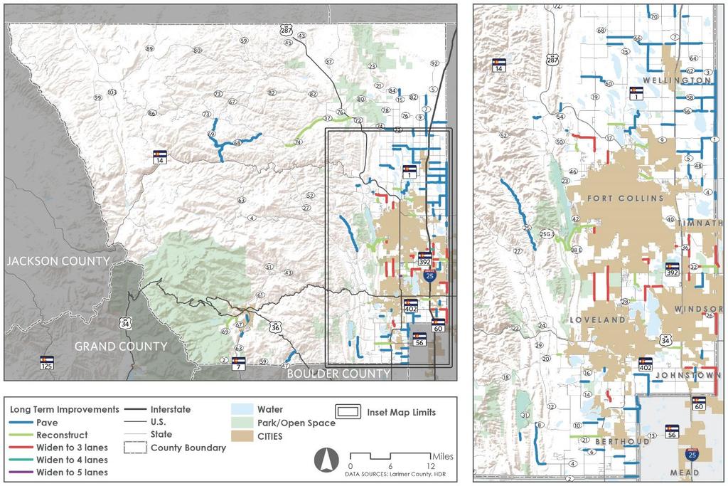
Chapter 2: Entire US287 Corridor
 Chapter 2: Entire US287 Corridor The US287 Study Area spans four incorporated jurisdictions and two counties. Due to the length and density of infrastructure along the US287 Study Area, corridor-wide maps
Auburn Trail / Ontario Pathways Trail Connector Feasibility Study Public Information Meeting Wednesday, August 22, 2012
 Auburn Trail / Ontario Pathways Trail Connector Feasibility Study Public Information Meeting Wednesday, August 22, 2012 Purpose of Feasibility Study Purpose Evaluate the feasibility of constructing a multiuse
Construction Staging Adelaide Street West
 REPORT FOR ACTION Construction Staging Adelaide Street West Date: October 6, 2016 To: Toronto and East York Community Council From: Acting Director, Transportation Services, Toronto and East York District
2015 PURDUE ROAD SCHOOL March 11, 2015
 2015 PURDUE ROAD SCHOOL March 11, 2015 Runway Protection Zone (RPZ) Definition It is a trapezoidal shape formed off the end of a runway and its geometry it a function of the airport s aircraft approach
2008 DEKALB COUNTY TRANSPORTATION PLAN (UPDATE)
") 2008 DEKALB COUNTY TRANSPORTATION PLAN (UPDATE) TABLE OF CONTENTS Introduction 1 Transportation Planning Activities 2 Identification of Problem Areas and Recommended Solutions 7 DeKalb County Projects
2008 DEKALB COUNTY TRANSPORTATION PLAN (UPDATE) TABLE OF CONTENTS Introduction 1 Transportation Planning Activities 2 Identification of Problem Areas and Recommended Solutions 7 DeKalb County Projects
Stage 2 ION: Light Rail Transit (LRT) from Kitchener to Cambridge
 from Kitchener to Cambridge") Stage 2 ION: Light Rail Transit (LRT) from Kitchener to Cambridge Public Consultation Centre (PCC) No. 3 Please Sign-in Cambridge City Hall November 21, 2017 2:00 to 8:00pm Preston Memorial Auditorium
Stage 2 ION: Light Rail Transit (LRT) from Kitchener to Cambridge Public Consultation Centre (PCC) No. 3 Please Sign-in Cambridge City Hall November 21, 2017 2:00 to 8:00pm Preston Memorial Auditorium
Committee Report. Community Development Committee For the Metropolitan Council meeting of August 12, Business Item No.
 Committee Report Business Item No. 2015-168 Community Development Committee For the Metropolitan Council meeting of August 12, 2015 Subject: Coon Creek Regional Trail Master Plan, Anoka County Proposed
Multimodal Planning Studies
 Multimodal Planning Studies Commuter Park and Ride Study Steering Committee Meeting June 6, 2013 Agenda 1. Update on Project Schedule 2. Update on Online Interactive Mapping 3. Key Themes from the Open
Other Principle Arterials Minor Arterial Major Collector Minor Collector Local
 CHAPTER 10 TRANSPORTATION Introduction The system of public roads in East Pikeland Township is decidedly rural in character. Since the 1984, the road network has remained much the same, with the addition
Appendix B Connecting Track Options Evaluation Criteria
 Appendix B Connecting Track Options Evaluation Criteria 608979-853_ra_July5-0_App Title Pages.Docx TTC ASHBRIDGES BAY MAINTENANCE AND STORAGE FACILITY CONNECTING TRACK ROUTE ALTERNATIVE - EVAULATION MATRIX.0
A number of goals were identified during the initial work on this Big Lake Transportation Plan.
 C. Transportation General Background Information Big Lake s transportation system includes all the roads, paths and facilities that allow the movement of private vehicles, trains and planes, as well as
Lake Erie Commerce Center Traffic Analysis
 LOCATION: East of NYS Route 5 at Bayview Road Town of Hamburg Erie County, New York PREPARED BY: Wendel Companies 140 John James Audubon Parkway Suite 200 Amherst, New York 14228 January 2012 i ii Table
Northwest Corridor LRT Line to Irving/DFW
 Northwest Corridor LRT Line to Irving/DFW AGENCY SCOPING May 25, 2005 NW to Irving/DFW Agenda: Introductions Project Development Process Project Update Federal Involvement Scoping Project Schedule Decisions
FINAL. Bicycle/Pedestrian Feasibility Study City of DeBary Dirksen Drive Trail. Prepared For: Volusia County MPO
 City of DeBary Dirksen Drive Trail FINAL Prepared By: Reynolds, Smith and Hills, Inc. Prepared For: Volusia County MPO September 2007 Table of Contents INTRODUCTION...1 PROJECT PURPOSE AND SCOPE...2 PHYSICAL
HIGHWAY RAIL GRADE CROSSING CONSOLIDATION PROGRAM
 HIGHWAY RAIL GRADE CROSSING CONSOLIDATION PROGRAM To decrease unnecessary train traffic exposure to life and property, promote public safety, and improve traffic conditions, the Texas Department of Transportation
Parkland County Municipal Development Plan Amendment Acheson Industrial Area Structure Plan
 Parkland County Municipal Development Plan Amendment Acheson Industrial Area Structure Plan New Plan Acheson Industrial Area Structure Plan Amendment Parkland County Municipal Development Plan Board Reference
Becker County Trail Routing Feasibility Study
 2016 Becker County Trail Routing Feasibility Study CONNECTING DETROIT MOUNTAIN AND MOUNTAIN VIEW RECREATIONAL AREA TO THE HEARTLAND TRAIL BECKER COUNTY ULTEIG ENGINEERS Contents Acknowledgements...2 INTRODUCTION...3
City of Solvang SUNNY FIELDS SPUR TRAIL STUDY
 City of Solvang SUNNY FIELDS SPUR TRAIL STUDY project description The City of Solvang, in partnership with the County of Santa Barbara Public Works Department, is developing an alignment study for a proposed
SR 934 Project Development And Environment (PD&E) Study
 Study") SR 934 Project Development And Environment (PD&E) Study Project Advisory Group Meeting March 1, 2018 State Road 934/NE/NW 79th Street from west of I-95 (NW 13th CT) to N. Bayshore Drive PD&E STUDY SR 934/NE/NW
SR 934 Project Development And Environment (PD&E) Study Project Advisory Group Meeting March 1, 2018 State Road 934/NE/NW 79th Street from west of I-95 (NW 13th CT) to N. Bayshore Drive PD&E STUDY SR 934/NE/NW
FEASIBILITY CRITERIA
 This chapter describes the methodology and criteria used to evaluate the feasibility of developing trails throughout the study areas. Land availability, habitat sensitivity, roadway crossings and on-street
Section II. Planning & Public Process Planning for the Baker/Carver Regional Trail began in 2010 as a City of Minnetrista initiative.
 Section II Planning & Public Process Planning for the began in 2010 as a City of initiative. city staff began discussions with the Park District on the possibility of a north/south regional trail connection
WELCOME! TSPE DFW MID-CITIES. January Chapter Meeting
 WELCOME! TSPE DFW MID-CITIES Check-in/Networking Announcements / Lunch Service Speaker Presentation 11:30AM 12:00PM 12:00PM 12:15PM 12:15PM 1:00PM January Chapter Meeting Thank You to Our Sponsors Interested
Community Development Department Council Chambers, 7:30 PM, October 4, Related Case P: Site Plan Approval
 STAFF REPORT 2018-34P: Street Vacation Community Development Department Council Chambers, 7:30 PM, October 4, 2018 To: From: Re: Paul Luke, Chairman, Skokie Plan Commission Mike Voitik, Associate Planner
Section 4(f) and Section 6(f) Technical Analysis
 and Section 6(f) Technical Analysis") WESTSIDE SUBWAY EXTENSION PROJECT Contract No. PS-4350-2000 Section 4(f) and Section 6(f) Technical Analysis Prepared for: Prepared by: WSP USA 851 SW Sixth Avenue, Suite 1600 Portland, Oregon 97204 FEBRUARY
WESTSIDE SUBWAY EXTENSION PROJECT Contract No. PS-4350-2000 Section 4(f) and Section 6(f) Technical Analysis Prepared for: Prepared by: WSP USA 851 SW Sixth Avenue, Suite 1600 Portland, Oregon 97204 FEBRUARY
PUBLIC INFORMATION SESSION #2
 Highway 16, Highway 779 to Kapasiwin Road, Planning Study PUBLIC INFORMATION SESSION #2 Wednesday June 20, 2012 4 to 8 pm HIGHWAY 16 Highway 779 to Kapasiwin Road Functional Planning Study Blueberry Community
ROUTE 20 CORRIDOR STUDY ---- Orange County, Virginia
 ROUTE 20 CORRIDOR STUDY ---- Orange County, Virginia Prepared by PARSONS Fairfax, Virginia on behalf of the: Rappahannock-Rapidan Regional Commission in cooperation with Orange County, Virginia Virginia
INGHAM COUNTY TRAILS AND PARKS TASK FORCE MEETING 2
 INGHAM COUNTY TRAILS AND PARKS TASK FORCE MEETING 2 October 22, 2015 Mannik and Smith Group Michigan Trails & Greenways Alliance AGENDA FOR TONIGHT 1. Project Approach, Process and Timeframe 2. Public
AGENDA ITEM 5 D WAKULLA ENVIRONMENTAL INSTITUTE (WEI) TRAIL FEASIBILITY STUDY
 TRAIL FEASIBILITY STUDY") March 19, 2018 AGENDA ITEM 5 D WAKULLA ENVIRONMENTAL INSTITUTE (WEI) TRAIL FEASIBILITY STUDY TYPE OF ITEM: Action STATEMENT OF ISSUE The Wakulla Environmental Institute (WEI) Trail is one of several trails
March 19, 2018 AGENDA ITEM 5 D WAKULLA ENVIRONMENTAL INSTITUTE (WEI) TRAIL FEASIBILITY STUDY TYPE OF ITEM: Action STATEMENT OF ISSUE The Wakulla Environmental Institute (WEI) Trail is one of several trails
Appendix F Environmental Data for Alternative Route Evaluation
 Appendix F Environmental Data for Alternative Route Evaluation (This page intentionally left blank) Cooks Point 138-kV Transmission Line Project Appendix F Index to Appendix F Environmental Data by Alternative
Executive Summary. MASTER PLAN UPDATE Fort Collins-Loveland Municipal Airport
 Executive Summary MASTER PLAN UPDATE Fort Collins-Loveland Municipal Airport As a general aviation and commercial service airport, Fort Collins- Loveland Municipal Airport serves as an important niche
1 PROJECT STATUS UPDATE 2 ND CONCESSION FROM BRISTOL ROAD TO DOANE ROAD TOWNS OF EAST GWILLIMBURY AND NEWMARKET
 Report No. 3 of the Regional Council Meeting of March 28, 2013 1 PROJECT STATUS UPDATE 2 ND CONCESSION FROM BRISTOL ROAD TO DOANE ROAD TOWNS OF EAST GWILLIMBURY AND NEWMARKET The recommends: 1. Receipt
STAFF REPORT. Airport Land Use Consistency Determination Betteravia Plaza. MEETING DATE: January 21, 2016 AGENDA ITEM: 8D
 STAFF REPORT SUBJECT: Airport Land Use Consistency Determination Betteravia Plaza MEETING DATE: AGENDA ITEM: 8D STAFF CONTACT: Andrew Orfila RECOMMENDATION: Adopt findings for the Betteravia Plaza project
City of Madison, Buckeye Road Monona Drive to Stoughton Road County AB Dane County Public Involvement Meeting
 City of Madison, Buckeye Road Monona Drive to Stoughton Road County AB Dane County Public Involvement Meeting Wednesday, May 31, 2017 6:30 to 8 P.M. Frank Allis Elementary School 4201 Buckeye Road Madison,
4. Safety Concerns Potential Short and Medium-Term Improvements
 NH Route 104 Access Management Study Page 19 4. Safety Concerns Potential Short and Medium-Term Improvements Potential safety improvement strategies are listed by priority based on field observations by
DRAFT FINAL REPORT AIRPORT MASTER PLAN. Rifle Garfield County Airport Revised May 15, 2014
 DRAFT FINAL REPORT AIRPORT MASTER PLAN Rifle Garfield County Airport Revised May 15, 2014 As required by Paragraph 425.B(4) of FAA Order 5100.38C, Airport Improvement Program (AIP) Handbook: The preparation
DRAFT TH AVE NE URBAN DESIGN MERIT PRESENTATION DPD# NOVEMBER 2017
 DRAFT 11.08.17 4801 24TH AVE NE URBAN DESIGN MERIT PRESENTATION 17-002 DPD#3027312 16 NOVEMBER 2017 PROJECT BACKGROUND URBAN DESIGN ANALYSIS VACATION / NO-VACATION COMPARISON URBAN DESIGN MERIT INTRODUCTION
Community Development Committee
 C Community Development Committee For the Metropolitan Council meeting of October 31, 2012 Committee Report Item:2012-316 ADVISORY INFORMATION October 16, 2012 Date Prepared: Subject: Intercity Regional
MARSHALL Subdivision. Township of Springwater, County of Simcoe. Traffic Brief for: Ontario Inc. Type of Document: Final Report
 MARSHALL Subdivision Township of Springwater, County of Simcoe Traffic Brief for: 489469 Ontario Inc. Type of Document: Final Report Project Number: JDE 1521 Date Submitted: October 19 th, 2016 10 / 19
CITY COUNCIL AGENDA MEMORANDUM
 To: Mayor and City Council From: Charles Ozaki, City and County Manager Prepared By: Kevin Standbridge, Deputy City and County Manager Katie Allen, City and County Engineer David Shinneman, Community Development
Fairfax County Parkway Widening Fairfax County
 Get Involved VDOT representatives will review and evaluate information received as a result of this meeting. Please fill out the comment sheet provided in this brochure if you have any comments or questions.
FNORTHWEST ARKANSAS WESTERN BELTWAY FEASIBILITY STUDY
 FNORTHWEST ARKANSAS WESTERN BELTWAY FEASIBILITY STUDY EXECUTIVE SUMMARY The 2030 Northwest Arkansas Regional Transportation Plan developed by the Northwest Arkansas Regional Planning Commission (NWARPC)
COMMENT PERIOD INTRODUCTION
 To: Interested Persons From: Tom Buford File: Del Rio Trail Project Date: June 8, 2018 Community Development Department Reference: NOTICE OF PREPARATION OF AN ENVIRONMENTAL IMPACT REPORT FOR THE DEL RIO
Grove Field Airport Environmental Assessment
 Grove Field Airport Environmental Assessment Advisory Committee Meeting #2 December 9, 2008 Port of Camas-Washougal Conference Room 6:00 7:30 PM Agenda: Welcome and Overview Dave Ripp, Director, Port of
BOARD OF SUPERVISORS AND VIRGINIA DEPARTMENT OF TRANSPORTATION JOINT PUBLIC HEARING
 BOARD OF SUPERVISORS AND VIRGINIA DEPARTMENT OF TRANSPORTATION JOINT PUBLIC HEARING Date of Hearing: September 14, 2016 #1 SUBJECT: ELECTION DISTRICT: Proposed FY2017-FY2022 Secondary Road Six-Year Plan
The Chu property is a 6.57 acre parcel located in the Town of Superior on the west side of McCaslin Boulevard. In 2014, the Town of Superior acquired
 1 The Chu property is a 6.57 acre parcel located in the Town of Superior on the west side of McCaslin Boulevard. In 2014, the Town of Superior acquired the Chu property for open space with a contribution
Trail # NW Tuesday, June DESIGN. Provide an Review the Provide an. Project Goals: System system. wayfinding
 I. Welcome / Introductions Bethany Creek Trail #2 Segment 3 Neighborhood Meeting #1 Bethany Presbyterian Church 15505 NW Springville Road, Portland, OR 97229 Tuesday, June 26, 2018 @ 6:00PM Meeting Minutes
Metrolinx Projects: Temporary Delegation for Long- Term Road Closures
 PW29.1 REPORT FOR ACTION Metrolinx Projects: Temporary Delegation for Long- Term Road Closures Date: April 24th, 2018 To: Public Works and Infrastructure Committee From: General Manager, Transportation
MESA COUNTY DEPARTMENT OF PUBLIC WORKS Administration - Building - Engineering Road and Bridge Traffic - Planning - Solid Waste Management
 MESA COUNTY DEPARTMENT OF PUBLIC WORKS Administration - Building - Engineering Road and Bridge Traffic - Planning - Solid Waste Management 200 S. Spruce St. P.O. Box 20,000 Grand Junction, Colorado 81502-5022
US 83 FROM NORTH OF THE STARR/ZAPATA COUNTY LINE TO LOMA BLANCA ROAD
 US 83 FROM NORTH OF THE STARR/ZAPATA COUNTY LINE TO LOMA BLANCA ROAD PUBLIC MEETING JUNE 8, 2017 Talk Text Crash 2 AGENDA TECHNICAL PRESENTATION (Roma Area Engineer Eduardo Gracia, P.E.) PROJECT SCHEDULE
Department of Public Works P.O Box 4186, San Rafael, CA / Fax: 415/
 Department of Public Works P.O Box 4186, San Rafael, CA 94913-4186 415/499-7877 Fax: 415/499-3724 Raul M. Rojas DIRECTOR San Antonio Road Bridge Replacement September 9, 2015 Community Meeting Summary
Community Development
 Community Development City & Borough of Juneau Community Development 155 S. Seward Street Juneau, AK 99801 (907) 586 0715 Phone (907) 586 4529 Fax DATE: February 11, 2016 TO: FROM: Planning Commission
1803 West Hwy 160 Monte Vista, CO (719) TTY (719)
 TTY (719)") USDA Forest Service Rio Grande National Forest http://www.fs.fed.us/r2/riogrande 1803 West Hwy 160 Monte Vista, CO 81144 (719)852-5941 TTY (719)852-6271 USDI Bureau of Land Management San Luis Valley Center
USDA Forest Service Rio Grande National Forest http://www.fs.fed.us/r2/riogrande 1803 West Hwy 160 Monte Vista, CO 81144 (719)852-5941 TTY (719)852-6271 USDI Bureau of Land Management San Luis Valley Center
Northwest Corridor LRT Line to Irving/DFW
 Northwest Corridor LRT Line to Irving/DFW SCOPING March 10, 2005 NW to Irving/DFW Agenda: Introductions Project Development Process Project Update Federal Involvement Scoping Project Schedule Decisions
Memo. Orange City Trail Plan Becky Mendez, AICP Jamie Krzeminski, PE, PTOE Matt Wiesenfeld, PE, AICP. Development of the Existing and Proposed Network
 Memo Date: Friday, December 22, 2017 Project: To: From: Subject: Trail Plan Becky Mendez, AICP Jamie Krzeminski, PE, PTOE Matt Wiesenfeld, PE, AICP Development of the Existing and Proposed Network HDR
 Appendix H1 Traffic Study Hill St Obispo Ave Obispo Ave Student Drop-off & Pick-up Area Parking Lot Plaza Level Hill St Fire Lane Access Service Lane Access Redondo Ave Redondo Ave Parking Lot N No
Summary of Committee Discussion/Questions Metropolitan Transportation Services Senior Planner Russ Owen presented this item.
 Committee Report Business Item No. 2017-191 Transportation Committee For the Metropolitan Council meeting of September 13, 2017 Subject: Final Crystal Airport 2035 Long Term Comprehensive Plan (LTCP) Proposed
June 2013: Capital Improvements Update. through $ 126,196,202 Available Funding through 2018 $ 149,783,656. Staff s Recommendation
 Capital Improvements Update June 2013: Pl dp j t Planned Projects through 2018 - $ 126,196,202 Available Funding through 2018 $ 149,783,656 pp p,, Un-appropriated - $ 23,587,454 Staff s Recommendation
November 11, 2009 BY . Planning and Growth Management Department 110 Laurier Avenue West, 4 th Floor Ottawa, Ontario K1P 1J1. Dear Mr.
 November 11, 2009 Planning and Growth Management Department 110 Laurier Avenue West, 4 th Floor Ottawa, Ontario K1P 1J1 BY E-MAIL Attention: Mr. Don Herweyer Dear Mr. Herweyer: Reference: Abbott-Fernbank
Laxon Terrace - Sarawia. Click to add title. Street Rail Level Crossing. Public Forum. December
 Laxon Terrace - Sarawia Click to add title Street Rail Level Crossing Public Forum December 2012 www.aucklandtransport.govt.nz Overview of Presentation Objectives and Reasons for Separation Project Background
METROPOLITAN COUNCIL 390 North Robert Street, St. Paul, MN Phone (651) TDD (651)
 TDD (651)") METROPOLITAN COUNCIL 390 North Robert Street, St. Paul, MN 55101 Phone (651) 602 1000 TDD (651) 291 0904 DATE: June 19, 2007 TO: Metropolitan Parks and Open Space Commission FROM: Jan Youngquist, Senior
METROPOLITAN COUNCIL 390 North Robert Street, St. Paul, MN 55101 Phone (651) 602 1000 TDD (651) 291 0904 DATE: June 19, 2007 TO: Metropolitan Parks and Open Space Commission FROM: Jan Youngquist, Senior
CHAPTER 6 NOISE EXPOSURE
 CHAPTER 6 NOISE EXPOSURE FAA requires that the NEM submitted for review represent the aircraft noise exposure for the year of submittal (in this case 2008) and for a future year (2013 for OSUA). However,
Redtail Ranch Preliminary Plan and Filing No. 1 Final Plat, Review #2 (SP , SF )
") COMMISSINERS: DARRYL GLENN (PRESIDENT) MARK WALLER (PRESIDENT PRO TEMPORE) PEGGY LITTLETON LONGINOS GONZALEZ, JR. STAN VANDERWERF COMMUNITY SERVICES DEPARTMENT PARK OPERATIONS ~ PLANNING ~ CSU EXTENSION
COMMISSINERS: DARRYL GLENN (PRESIDENT) MARK WALLER (PRESIDENT PRO TEMPORE) PEGGY LITTLETON LONGINOS GONZALEZ, JR. STAN VANDERWERF COMMUNITY SERVICES DEPARTMENT PARK OPERATIONS ~ PLANNING ~ CSU EXTENSION
2. Goals and Policies. The following are the adopted Parks and Trails Goals for Stillwater Township:
 D. PARKS AND TRAILS 1. Introduction Stillwater Township s population is relatively low, with most residents living on rural residences on large lots. The need for active park space has been minimal in
Staff Report Sign Design
 Staff Report Sign Design July 29, 2014 Planning & Zoning Commission Meeting Report date July 23, 2014 Project type Sign Design Legal description Section 2, Township 5, Range 82 Lots 3&4, S1/2NW1/4, SW1/4
INFORMATION PAPER TO THE STRATEGIC DEVELOPMENT COMMITTEE
 INFORMATION PAPER TO THE STRATEGIC DEVELOPMENT COMMITTEE BRIEFING ON RONALD REAGAN WASHINGTON NATIONAL AND WASHINGTON DULLES INTERNATIONAL AIRPORTS CAPITAL CONSTRUCTION PROGRAM APRIL 2015 2015 Use & Lease
SUPER VACANT LAND REAL ESTATE OPPORTUNITIES
 SUPER VACANT LAND REAL ESTATE OPPORTUNITIES ESTATE SALE Panama City - Bay County, Florida - Northwest Florida 12 VACANT LAND PARCELS AVAILABLE From.72± Acres up to 130± Acres Available Waterfront and Interior
MERIDIAN A \[0~~~~1' AGENDA CHARTER TOWNSHIP OF MERIDIAN MERIDIAN TRANSPORTATION COMMISSION January 18, :00 p.m.
 ~ MERIDIAN A \[0~~~~1' ~ AGENDA CHARTER TOWNSHIP OF MERIDIAN MERIDIAN TRANSPORTATION COMMISSION January 18, 2018 6:00 p.m. 1. CALL MEETING TO ORDER 2. APPROVAL OF AGENDA 3. APPROVAL OF MINUTES A.November16,2017
Sundance Square. Liberty Hill, Texas 78642
 RETAIL / OFFICE DEVELOPMENT OPPORTUNITY Bulk Sale of ±24 Acres at $4.00 / sq. ft. Existing Williamson CAD Tax Parcels Property Features Area of high residential development growth Situated at the entrance
Project Overview. Hunter Mill Road Over Colvin Run Bridge Replacement Fairfax County. Get Involved. Public Information Meeting. Contact Information
 Get Involved VDOT representatives will review and evaluate any information received as a result of the public information meeting. The comment sheet in this brochure is provided to assist in making your
The Baker/Carver Regional Trail is intended to
 Section V Design Guidance The Baker/Carver Regional Trail is intended to safely accommodate 183,000 annual visits, an array of non-motorized uses, a variety of skill levels, and persons with special needs.
THREE MILE PLAN TOWN OF SUPERIOR COLORADO
 THREE MILE PLAN TOWN OF SUPERIOR COLORADO February 23, 2015 INTRODUCTION This document has been prepared by the Town of Superior, Colorado, to address the existing and proposed land uses within an approximate
Abbott Rd Rehabilitation Phase II - Elmore Rd to Birch Rd
 Abbott Rd Rehabilitation Phase II - Elmore Rd to Birch Rd Project ID SOA07003 Department State of Alaska Project Type Improvement Start Date December 2017 Location Assembly: Section 4, Seats F & G, Assembly:
SOUTH STRATHCONA COUNTY TRUCK FILL
 SOUTH STRATHCONA COUNTY TRUCK FILL Council Meeting Date: January 14, 2014 Agenda Item #:11.1 Report Purpose To recommend a truck fill location based on technical evaluations and resident feedback. Recommendation
4 VIVA PHASE 2 YONGE STREET - Y2, AND HIGHWAY 7 - H3 CORRIDORS PRELIMINARY ENGINEERING UPDATE
 4 VIVA PHASE 2 YONGE STREET - Y2, AND HIGHWAY 7 - H3 CORRIDORS PRELIMINARY ENGINEERING UPDATE The Rapid Transit Public/Private Partnership Steering Committee recommends the following: 1. The presentation
WELCOME US 83 Public Meeting
 WELCOME US 83 Public Meeting From north of the Starr/Zapata County Line to Loma Blanca Road Thursday, June 8, 2017 Roma Middle School Lecture Hall Open House: 5 6 p.m. Presentation and Public Comment:
HILLSBORO AIRPORT MASTER PLAN UPDATE Planning Advisory Committee Meeting 1
 HILLSBORO AIRPORT MASTER PLAN UPDATE Planning Advisory Committee Meeting 1 Feb. 27, 2017 HILLSBORO AIRPORT MASTER PLAN UPDATE Planning Advisory Committee Welcome Curtis Robinhold, Port of Portland 1 HILLSBORO
Design Meeting Presentation
 Contract No. 17ECS-TI-05SP April November 2017 Design Meeting Presentation November 2015 Agenda Items: Introduction (5 min) Overview (10 min) Scope of work (60 min): Schedule and Traffic Staging / Closures
Sudbury to Hudson Transmission Reliability Project
 An independent assessment of routing options Sudbury to Hudson Transmission Reliability Project and use of a rail-banked corridor for this purpose Prepared by: NorthEast Logistics Systems, LLC August 29,
C. APPROACH FOR IDENTIFYING THE BEST ROUTES FOR THE NEEDED TRANSMISSION SYSTEM IMPROVEMENTS
 C. APPROACH FOR IDENTIFYING THE BEST ROUTES FOR THE NEEDED TRANSMISSION SYSTEM IMPROVEMENTS CL&P s approach for identifying the best routes for the needed transmission system improvements included a determination
VI. ALTERNATIVES TO THE MASTER PLAN C. RENOVATED EAST BUILDING ALTERNATIVE
 VI. ALTERNATIVES TO THE MASTER PLAN C. RENOVATED EAST BUILDING ALTERNATIVE INTRODUCTION The Renovated East Building Alternative would include the continued use of the renovated West Building and the renovation
TONGASS NATIONAL FOREST
 TONGASS NATIONAL FOREST UNITED STATES DEPARTMENT OF AGRICULTURE-FOREST SERVICE Contact: Dennis Neill Phone: 907-228-6201 Release Date: May 17, 2002 SEIS Questions and Answers Q. Why did you prepare this
Northeast Stoney Trail In Calgary, Alberta
 aci Acoustical Consultants Inc. 5031 210 Street Edmonton, Alberta, Canada T6M 0A8 Phone: (780) 414-6373, Fax: (780) 414-6376 www.aciacoustical.com Environmental Noise Computer Modelling For Northeast Stoney
Draft Concept Alternatives Analysis for the Inaugural Airport Program September 2005
 Draft Concept Alternatives Analysis for the Inaugural Airport Program September 2005 Section 3 - Refinement of the Ultimate Airfield Concept Using the Base Concept identified in Section 2, IDOT re-examined
US 83 Relief Route. City of La Joya City of Peñitas Hidalgo County. November 15, 2012
 US 83 Relief Route City of La Joya City of Peñitas Hidalgo County November 15, 2012 TxDOT Mission: Work with others to provide safe and reliable transportation solutions for Texas. Public Meeting Agenda
Susitna-Watana Hydroelectric Project (FERC No ) Recreation Resources Study Study Plan Section Study Implementation Report
 Recreation Resources Study Study Plan Section Study Implementation Report") (FERC No. 14241) Recreation Resources Study Study Plan Section 12.5 2014 Study Implementation Report Prepared for Prepared by AECOM November 2015 TABLE OF CONTENTS 1. Introduction... 4 2. Study Objectives...
(FERC No. 14241) Recreation Resources Study Study Plan Section 12.5 2014 Study Implementation Report Prepared for Prepared by AECOM November 2015 TABLE OF CONTENTS 1. Introduction... 4 2. Study Objectives...
9 CONSTRUCTION OF BATHURST STREET FROM GREEN LANE WEST TO SOUTH OF HIGHWAY 11, TOWN OF EAST GWILLIMBURY AND TOWNSHIP OF KING
 Clause No. 9 in Report No. 9 of Committee of the Whole was adopted, without amendment, by the Council of The Regional Municipality of York at its meeting held on May 15, 2014. 9 CONSTRUCTION OF BATHURST
IL 390 Station. Wood Dale Open House Summary 5/18/17
 Wood Dale Open House Summary 5/18/17 The first public open house for the Wood Dale Comprehensive Plan took place on May 18 th, 2017. The program was conducted as a fun community event and there were 216
STAGE 2 & 3 Pavement reconstruction within viaduct footprint, pavement widening and resurfacing N/S of viaduct footprint, sidewalk
 STAGE 1 Viaduct removal, deck replacement on the River Bridge, and approach of the Chicago River Bridge north to Roscoe) Maintain local access roadways - 1 lane in each direction A signed alternate route
Great Wolf Lodge Fact Sheet & Frequently Asked Questions Potential Location in Gilroy, California 8/30/17
 WHAT? Great Wolf Resorts has identified Gilroy, California as a potential location for a new Great Wolf Lodge family resort and has entered into a 60-day period of exclusivity with the City and community
Honorable Members of the Mobility Solutions, Infrastructure and Sustainability Committee
 Memorandum DATE August 10, 2018 CITY OF DALLAS TO Honorable Members of the Mobility Solutions, Infrastructure and Sustainability Committee SUBJECT Dallas Love Field Master Plan Update On Monday, August
City of Grand Island Tuesday, December 12, 2017 Council Session
 City of Grand Island Tuesday, December 12, 2017 Council Session Item E-3 Public Hearing on One & Six Year Street Improvement Plan Council action will take place under Resolution item I-1. Staff Contact:
Business Item No
 Metropolitan Parks and Open Space Commission Meeting date: February 6, 2018 For the Community Development Committee meeting of February 20, 2018 For the Metropolitan Council meeting of February 28, 2018
EXISTING CONDITIONS A. INTRODUCTION. Route 107 Corridor Study Report
 II. EXISTING CONDITIONS A. INTRODUCTION The Route 107 study area extends from the south at Chestnut Street in Lynn approximately 3.7 miles to the north to Boston Street in Salem. The study area has three