SMRPD Draft Master Plan of Trails, Adopted Oct. 14, 2004
|
|
|
- Giles Foster
- 5 years ago
- Views:
Transcription


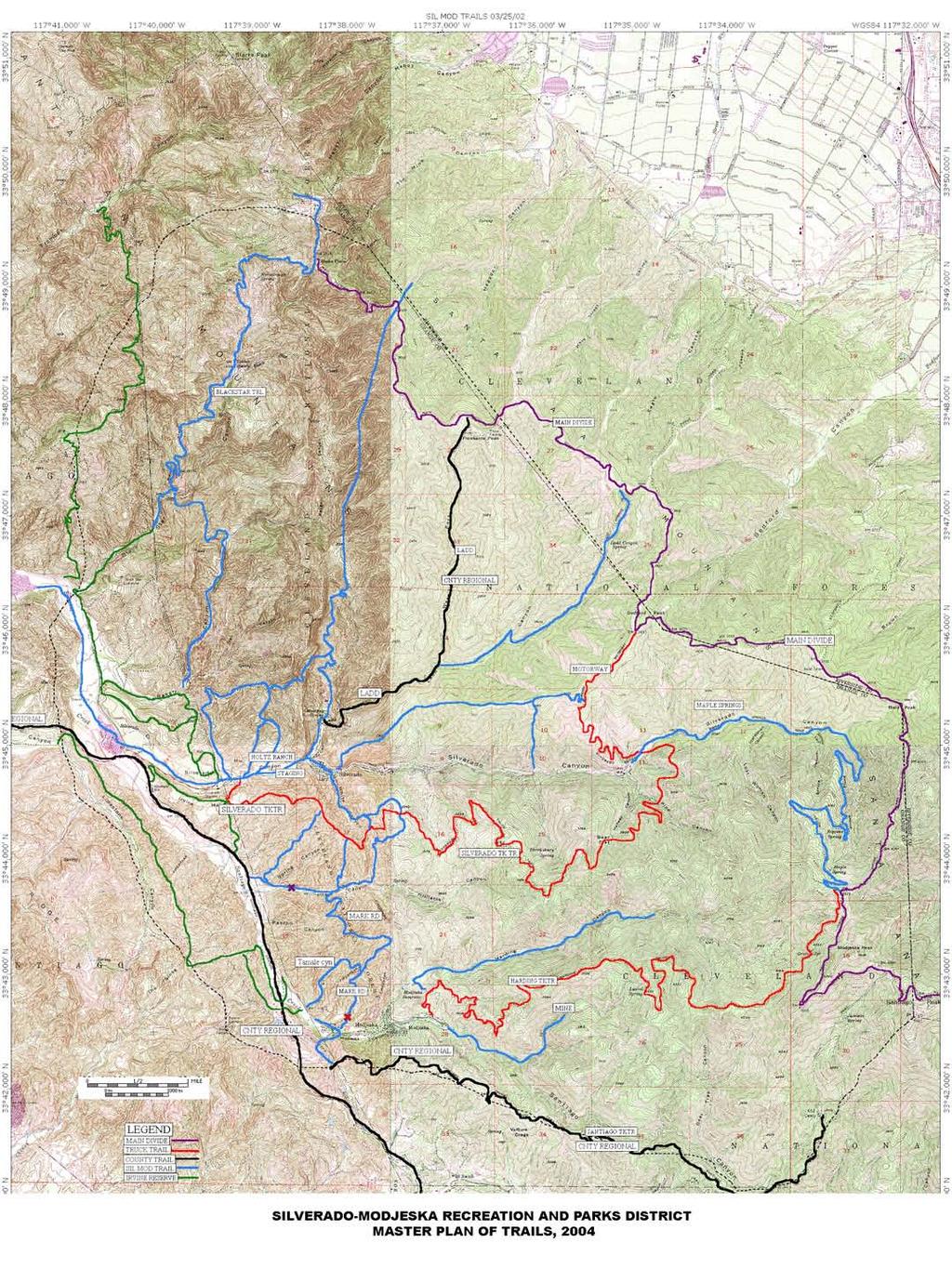
1 P.O. BOX 8, SILVERADO, CA SMRPD Draft Master Plan of Trails, Adopted Oct. 14, 2004 The Master Plan of Regional Riding and Hiking Trails Component is countywide in scope. It is a public trail system which traverses the entire county without regard for jurisdictional boundaries and, therefore, intergovernmental coordination is necessary for successful implementation. -from the Recreation Element of the Orange County General Plan The Silverado Modjeska Community Plan and EIR (DEIR 096), prepared by the Environmental Planning Agency and distributed on November 23, 1976, included a variety of non-paved multi-use riding and hiking trails which were in place and inventoried at the time of the DEIR s adoption. The plan allowed for the addition of recreational trails as proposed by the community. In 2002, under the jurisdiction of the Silverado Modjeska Recreation and Parks District (a State sanctioned Independent Special District), the community and the SMRPD worked together to create an updated Master Plan of Riding and Hiking Trails. As a conceptual plan, it is considered a general expression of community values and is abstract in nature. Purpose The purpose of the Silverado Modjeska Master Plan of Trails is to provide goals and objectives to direct the development and operation of a District-wide public trail system that serves the recreational needs of equestrians, pedestrians (walkers, hikers and joggers), and mountain bikers (non-motorized). Goals Goal 1: Provide a useful, enjoyable, safe, and efficient riding and hiking trail system for the District and to meet the needs and desires of the community. Goal 2: Create trail linkages between open space and recreation facilities, between community, municipal, state, and federal trail systems, and create connectivity to surrounding communities. Goal 3: Create partnerships between governing agencies, land owners and Conservancies which overlap the District, ensuring the implementation of the Master Plan of Trails, and allowing for efficient acquisition, development, and operation of the trail system. Objectives Objective 1: Implement and maintain a District riding and hiking trail system as depicted conceptually on the Trails Map. Objective 2: Develop a District trail system to meet the recreational needs of equestrians, pedestrians (walkers, hikers and joggers), and mountain bikers (non-motorized).
2 Objective 3: Coordinate with other local jurisdictions and state and federal agencies regarding trail development and maintenance. Objective 4: Accept irrevocable offers to provide trail links that allow for implementation of the District trail system in a logical immediately usable fashion. Objective 5: Create a strategy for the sequencing of trail development in order to maximize scarce funding. Policies The District Riding and Hiking Trails system shall be developed and operated as follows: 1. The dedication and acquisition of trail right-of-way and construction and improvements shall be pursued as a condition of approval of development projects (i.e., irrevocable offers of recreation easements) consistent with the Master Plan. 2. The anticipated cost of acquisition, development, maintenance, and operation shall be considered in the process of making decisions. 3. The District shall actively pursue public and private funding (Developer Endowments), including grants and gifts as a source of funding to implement District Trail Plan. 4. The design and location of trails shall be sensitive to cultural and natural resources such as archaeological sites, wildlife corridors, plant habitats, rare and endangered species, etc. 5. Whenever possible the use of the County of Orange Riding and Hiking Trails Design Manuel, specifically the "steep terrain single track trails" guidelines shall be considered. 6. Where appropriate and feasible (i.e. Truck Trails and existing ranch roads) in rural areas District trails may serve as fuel breaks and as vehicular access for law enforcement, fire, emergency and public utility vehicles. 7. Safety shall be a primary consideration for allowing/restricting the use of trails by equestrians, pedestrians (walkers, hikers and joggers), and mountain bikers, respectively. Description of Trails Orange County Regional Trails within the Silverado Modjeska Recreation and Parks District Hicks Canyon Trail: This trail follows the existing haul road from Irvine Lake to Jeffrey Road. Currently it is being negotiated into the East Orange Development. This trail will begin at the intersection of Santiago Canyon Road and the Haul Bridge (Bat Bridge) and could offer connectivity out of the District and to destinations such as Irvine Lake and the Great Park. It is on the County Master Plan of Riding and Hiking Trails, the Sil-Mod Master Plan of Riding and Hiking Trails and must also be coordinated with the joint powers of authority such as City of Orange, City of Irvine, Irvine Ranch Land Reserve and OCFA. This trail is not considered challenging. It is a wide existing road with the potential for an existing grade separated crossing at Santiago Canyon Road. It is ideal for all types of trail users. 6 miles of easements are needed from the Irvine Company to complete this trail. Holy Jim Trail: This trail may cross several private properties at its base, but lies primarily in the congressional boundary of the Cleveland National Forest (CNF). Although it is on the County s Master Plan, it is under the jurisdiction of the Federal Government. The Trail begins at the Holy Jim Road fork of Trabuco Canyon Road, just a few miles from the main entrance of O Neil Park. The trail begins by paralleling Holy Jim Creek, then climbs swiftly up the ridge to the west, eventually terminating at the Main Divide Trail. This trail is 3.4 miles long. This trail is steep and challenging, and often suffers washouts during seasons of heavy rain. It provides connectivity from O Neil Park to the CNF and the Main Divide Road.
3 Joplin Trail: The Joplin Trail is on the County Master Plan of Trails and the Foothill Trabuco Specific Plan/Trails, but lies entirely within the boundary of the Cleveland National Forest. It is considered a connector trail, in which it provides connection from the Santiago Truck Trail to Rose Canyon and eventually to Live Oak Canyon Road. This trail is approximately 1.8 miles long and is considered challenging. Ladd Canyon Trail: This trail is currently on the Regional Riding and Hiking Trail Map for the County of Orange. Although it is considered some of the most beautiful scenery in the Santa Ana Mountains, it offers almost insurmountable obstacles as a multi-use trail, in the upper portion of the canyon. The exception is the lower trail portion traveling along the northern edge of Silverado Canyon Road. The trail originates at the Main Divide Road and is an old abandoned Forest Service road. Due to the presence of endangered species, the Federal Government has elected to abandon this road/trail and does not promote trail use in this area. Currently, the SMRPD along with the County of Orange have reached a memorandum of understanding with a property owner (CCRC Farms) which includes a staging area, additional connector trails and the implementation of the county trail across the front of the development. The Ladd Canyon Trail could be reasonably reduced to originating at the staging area on Silverado Canyon Road at the Riviera", continuing east alongside the road creating connectivity to the Silverado Truck Trail and the Irvine Ranch Land Reserve (IRLR). At the boundary of the IRLR the trail should veer north away from the road following the creek, making use of an existing haul road, continuing to the mouth of Silverado Canyon and connecting to the Santiago Creek Trail. This trail also provides connectivity to Baker and Black Star Canyons. This reduced trail could consist of 2 miles of relatively easy multi-use trail and is only 3 dedications away from completion. Main Divide Trail: This trail is entirely within the boundary of the CNF and is under Federal jurisdiction. It traverses the crest of the Santa Ana Mountains from the northern Sierra Peak to the southern Ortega Highway. It travels over 38 miles in its entirety and is considered the origination or destination point for a "mountains to the sea" trail effort. Important connector trails originating within the District would be: Black Star Canyon Road, Maple Springs Road, Silverado Truck Trail, Modjeska Canyon Trail/Harding Truck Trail, Santiago Truck Trail/ Joplin Trail, Holy Jim Trail. Modjeska Canyon Trail/ Harding Truck Trail: This trail originates at the Tucker Wildlife Bird Sanctuary on Modjeska Canyon Road. It is currently complete and is widely used. As of late, it is completely under the jurisdiction of the Federal Government. It is 4 miles long, travels due east and zigzags through several canyons. It makes possible loop trips with the Santiago Truck Trail/ Joplin Trail and it connects to the Main Divide Trail. Santiago Creek Trail: This trail parallels Santiago Canyon Road from Trabuco Canyon Road (Cook s Corner) to Irvine Lake. Currently the County of Orange/Sil-Mod Recreation and Parks District/ City of Orange and The Irvine Company are negotiating the final alignments. Although the County will have the ultimate say, the alternatives currently being considered are both the north side and the south side of Irvine Lake, terminating at Irvine Park. It is the desire of the District to see a trail follow Santiago Creek into the backside of Irvine Park. This trail will include 15 miles of trail in its entirety. The Irvine Company in conjunction with the East Orange Project will dedicate half of those miles. This trail will be easily accessible and easy to use, built to County standards. Santiago Truck Trail: This trail is 6.2 miles in length and originates at the highest point of the Modjeska Grade Road. The road is a public right-of-way across one mile of private land. This trail terminates at Old Camp, an old CCC Camp from the 1930 s. It is at this junction that the trail connects to the Joplin Trail, which continues down into Rose Canyon or up to the Main Divide Trail. This Trail is quite popular as a multi-use trail, and is included on the County Master Plan of Trails and the SMRPD Master Plan of Riding and Hiking Trails. Vulture Crags Trail: This trail is on the County Master Plan of Trails. It is at the very southern portion of the Silverado Modjeska Recreation and Parks District (SMRPD) boundary and is included in the Foothill Trabuco Specific Plan as a riding and hiking trail. It connects Santiago Truck Trail to Live Oak Canyon Road near the
4 Hamilton Truck Trail. Total trail miles are 2.4, of which 1 mile still needs to be constructed (to a County level of acceptance), however it is currently in use by trail users, to access upper Santiago Truck Trail. Silverado Modjeska Recreation and Parks District Master Plan Trails Fremont Canyon Trail: This trail originates at Santiago Creek just northwest of the sharp right turn on Black Star Canyon Road (Beyond the locked gate). It travels north and terminates in upper Fremont Canyon and is actually an Edison Service Road. This trail creates connectivity to the northern alignment of the Santiago Creek Trail (North side of Irvine Lake) which is currently being explored by the joint powers of authority. It is the intent of the Silverado Modjeska Recreation and Parks District to either continue the Ladd Canyon Trail beyond the mouth of Silverado Canyon to parallel Santiago Creek to reach Irvine Park, or combine efforts with the County of Orange to detour the Santiago Creek Trail away from Santiago Canyon Road, taking it behind Irvine Lake. Black Star Trail/ Black Star Canyon Road: This trail begins at the junction of Black Star Canyon Road and Silverado Canyon Road. It is adjacent to the road, which is currently a public right-of-way. 1.1 miles north of the Silverado Junction, the County of Orange has installed a locked gate, limiting vehicular access to landowners and emergency vehicles. This has also limited trail users and eliminated equestrian access. It is the goal of the SMRPD to meet the needs of all trail user groups. Black Star Canyon Trail begins in lower Black Star Canyon then gains in elevation through a series of switchbacks to the Main Divide Trail above Hidden Ranch near Beek s Peak. This trail creates vital connectivity to Riverside County via Skyline Drive. It is 7.9 miles in length. Baker Canyon Trail: This trail originates at Baker Canyon Rd. (near the power line crossing) and travels north to upper Black Star Canyon Road. Thus creating a large loop trail outside of Baker Canyon. This trail follows the current existing fire road and travels across several large parcels of private property. This trail has the potential to connect the Flying B Ranch Camp Ground/ RV Park with Black Star Trail/ Main Divide Trail and Fremont Canyon. Baker Canyon Loop Trail: The Nature Conservancy (TNC) is currently using this trail with docent lead hikes. The Baker Canyon Loop originates at the junction of Black Star Canyon Road and Baker Canyon Road. The staging area is behind a locked gate off Baker Canyon Road. The trail itself starts at the mouth of Baker Canyon and travels along Black Star Canyon Road, then begins to gain in elevation traveling east, reaching the Edison Connector trail (at the highest electrical tower). Then the trail travels north dropping in elevation to the bottom of Baker Canyon, paralleling the creek and arriving back at the mouth of Baker Canyon and Black Star Canyon Road. Edison Connector Trail: This trail creates connectivity between the Ladd Canyon Trail and the Baker Canyon Loop Trail. Although within the congressional boundary of the CNF, it is entirely on the Irvine Ranch, specifically on the Irvine Ranch Land Reserve (IRLR). This trail makes use of the existing ranch road and Edison Service Road. It creates connectivity to existing County staging at Carbondale Ranch, additional staging for the SMRPD at the "Riviera" via the Ladd Canyon Trail. It creates connectivity to Black Star Canyon, Fremont Canyon, etc. Stable Loop: This single track trail originates at Silverado Creek behind the equestrian center and travels north on several parcels of private property then turns east to connect to the West Ridge and the Old Holtz Trail at Holtz Ranch. This site (Holtz Ranch) is currently under plan for development and may interrupt some trail usage. A memorandum of understanding has been reached by the SMRPD, the County of Orange and the Developer to establish equitable trails on the southern side of the property across Silverado Canyon Road. The current language does not preclude the later development of these trails.
5 Mustang Springs Trail: This trail originates at Mustang Springs in Ladd Canyon and travels north up the west fork. The terrain is vigorous because of the "reef" formation, and may be difficult to meet multi-use standards. This trail has unknown connectivity. Silverado-Ladd Ridge Trail: This trail originates behind the Silverado Post office on private property, and travels along the ridge between the northern rim of Silverado Canyon and the southern rim of Ladd Canyon on the east fork. This trail connects Silverado Canyon Road (near downtown) to the Silverado Motorway, it allows for recreational trail users to parallel Silverado Canyon Road with out having to travel on it. Silverado Motorway: This trail originates near the Forest Service Gate at the bottom of the Maple Springs Truck Trail. On the northern side of the road, it switchbacks up to the Main Divide at Bedford Peak. Although this road was traditionally viewed as a fuel break for Silverado Canyon residents for many years, it has fallen into disrepair and neglect due to Forest Policy changes through out the years. This trail provides valuable connectivity to the Main Divide Trail, the Silverado-Ladd Ridge Trail, and Maple Springs Truck Trail/ Silverado Canyon Road. Silverado Truck Trail: This trail traverses the entire length of the southern rim of Silverado Canyon for about 8 miles. It originates at Santiago Canyon Road near the Silverado Children s Center traveling east toward the Main Divide within the boundaries of the Cleveland National Forest. This trail was originally built jointly by the County of Orange and the Federal Government. It served as both a truck trail for the forest as well as a fuel break for the community of Silverado, and was up until the bankruptcy, maintained by the California Division of Forestry and the Orange County Fire Authority. Although this trail has suffered major erosion from the recent heavy rains, and has suffered from a number of private gates being placed along it, it continues to be the most popular trail in Silverado and Williams Canyon. The Irvine Company has recently expressed an interest in building a new staging area to access this trail near Santiago Canyon Road at the junction of the County s proposed Santiago Creek Trail. There is an unpassable slide at Bear Flats, and the Federal government has been requested to add the removal of the slide to the 20 year management plan for the CNF. Currently this idea has gained much momentum, as it qualifies as a multi-use "mountains to the sea" trail, the County of Orange has recently considered upgrading this trail to its Master Plan of Riding and Hiking Trails. There are several access points from Silverado Canyon Road and Williams Canyon Road. Mesa Trail: This trail connects the Ladd Canyon Trail at Silverado Canyon Road to the Silverado Truck Trail on the Irvine Mesa. There is currently a private property gate, which allows equestrian, hiking and biking access. This trail is 1/4 mile in length and is a wide dirt road sharing limited vehicular access. White s Canyon: This trail originates at Silverado Canyon Road just east of the Silverado Café. It shares vehicular access on private roads, across private property. The original community residents established this trail as a shared easement. It is currently a popular access trail to the Silverado Truck Trail but has absolutely no potential to improve below the property of John Ibarra. At best it serves as a popular and convenient access for local residents. Williams Canyon Ridge Connector: This trail starts at Williams Canyon Road near the water tower and travels north along a steep ridge terminating at the Silverado Truck Trail. It is very steep and has been severely damaged by illegal off-road use. It is approximately one mile in length. Wild Oat: This trail connects Williams Canyon Road with the Silverado Truck Trail. It is currently used as vehicular access to several parcels of private property, but is commonly used by all trail user groups. It is midway through Williams Canyon with switchbacks that make it an ideal trail, creating connectivity to Silverado Canyon. Shaw s: This trail is at the end of Williams Canyon traveling to the north connecting with the Silverado Truck Trail at the Shaw s property. It is a popular connection from Silverado Canyon to Williams Canyon.
6 Williams Canyon Road: This road travels along the bottom of Williams Canyon and is one lane. It has no potential for improvement and must be shared use with vehicular traffic, however due to the limited residents, it makes it possible for on road trail use. This road creates connection to the Santiago Creek Trail along Santiago Canyon Road, and creates connection to both Silverado and Modjeska Canyons. Currently a gated entrance is under construction at the mouth of Williams Canyon, however, the residents have allowed for an equestrian/hiking/biking entrance to be added. Mark Road: This trail travels from Williams Canyon Road near the development of Williams Springs Estates, through a series of switchbacks and terminates at Markeson Road in Modjeska Canyon. It is critical for connection from Williams Canyon to Modjeska Canyon and should be open to all user groups. Trail users can access the Modjeska Creek Trail near the area of Shadowland Estates. Tamale Canyon: This trail connects Mark Road Trail to Modjeska Canyon Road. Access to the Modjeska Creek Trail is possible through Croatian Way via an at grade crossing. Combined with Mark Road, it creates a valuable loop trail for the residents of Modjeska Canyon. Modjeska Creek Trail: This trail runs along the Modjeska Grade Road traveling over steep topography and eventually joining Modjeska Creek just prior to its joining Santiago Creek. It is a difficult trail to complete between the Grade Road and the creek bottom. There are currently easements in place, which double as Edison easements at the top of the Grade Road. A single-track trail could be put into place connecting the top of the Grade to the Creek bottom. This trail would be challenging, but would create vital connection for local residents to both the County s Santiago Creek Trail and the Federal Government s Santiago Truck Trail. The most crucial point of connection is the intersection of Modjeska Creek and Santiago Canyon Road. This trail should travel under the current overpass to take advantage of an existing grade separated crossing. It provides for connectivity from Modjeska Canyon into the County Regional Park of Limestone Canyon. It should continue on the west side of Santiago Canyon Road until it meets Hangman s Trail. Irvine Ranch Land Reserve/Limestone Regional Park Trails Sinks Trail: This trail begins behind the locked gate at the Hangman s Tree Spur Road parking area, near the mouth of Modjeska Canyon. It proceeds up Hangman s Tree Spur Road to the Sinks, a geological formation consisting of eroded sandstone, where the land drops off sharply into Agua Chinon Canyon. Used as either an outand-back trail on the existing road, or usable also as a loop trail utilizing a footpath down a ridge just north of the road, it is 2 ½ miles long. Dripping Springs Trail: This loop trail starts at the parking area behind the locked gate near Santiago Canyon Road, drops down into the bottom of Limestone Canyon, proceeds up the canyon to a tributary canyon just north of Elephant Peak, then heads west uphill to Dripping Springs, one of the only year-round springs in the county. From the springs it continues uphill on an old Irvine Ranch road to a ridge west of Limestone Canyon, then down into the canyon again and back to the parking area. Mileage is 3 ½ miles. Descriptions for Limestone Canyon and Loma Ridge Trail, Hangman s Canyon and Whiting Ranch Wilderness Park Trail, Agua Chinon Canyon Trail, Hicks Haul Road Trail, and Legal Language for IRLR Trails are all Works in Progress. At the Oct. 14, 2004 meeting, the District Board of Directors unanimously approved Resolution , adopting the Draft District Master Plan of Trails, which is now a legal document describing existing and proposed Class 1, 2, and 3 trails within the District, some of which are within the East Orange Planned Community Areas 2 and 3. This plan was prepared by Trails Committee Volunteer Dana Judd, with assistance from Director Mike Boeck.
7
Trail Phasing Plan. Note: Trails in the Clear Creek Canyon area (Segments will be finalized in the future to minimize wildlife impacts
 Note: Trails in the Clear Creek Canyon area (Segments 2 5 and a future JCOS connection) will be finalized in the future to minimize wildlife impacts Trail Phasing Plan P Parking 3 Easy Trail Intermediate
Preferred Recreation Recommendations Stemilt-Squilchuck Recreation Plan March 2018
 Preferred Recreation Recommendations Stemilt-Squilchuck Recreation Plan March 2018 Below are the recommended recreation ideas and strategies that package together the various recreation concepts compiled
Non-motorized Trail Plan & Proposal. August 8, 2014
 Town of Star Valley Ranch, Wyoming and the Star Valley Ranch Association in partnership with the USDA Forest Service, Bridger-Teton National Forest, Greys River Ranger District Non-motorized Trail Plan
Blueways: Rivers, lakes, or streams with public access for recreation that includes fishing, nature observation, and opportunities for boating.
 Parks, Open Space and Trails PRINCE WILLIAM COUNTY 2008 COMPREHENSIVE PLAN TRAILS PLAN CONTENTS The components of the trails plan are: Intent Definitions Goals, Policies, and Action Strategies Trails Map
January 14, Orange County Transportation Authority Attn: M2 NCCP/HCP 550 South Main Street P.O. Box Orange, CA
 Equestrian Trails, Inc. Corral 357 P.O. Box 1026 Trabuco Canyon, CA 92678 http://saddlebackcanyonriders.com/ President: James Iacono... 714-612-1789 January 14, 2016 Orange County Transportation Authority
EXECUTIVE SUMMARY PROGRAM DEVELOPMENT REPORT PURPOSE EXISTING SETTING EXPANDING PARKLAND
 EXECUTIVE SUMMARY PROGRAM DEVELOPMENT REPORT PURPOSE As the culmination of the first phase of the master planning process, this Program Development Report creates the framework to develop the Calero County
FEASIBILITY CRITERIA
 This chapter describes the methodology and criteria used to evaluate the feasibility of developing trails throughout the study areas. Land availability, habitat sensitivity, roadway crossings and on-street
Table 1: Santiago Peak Communication Site. Latitude 1 Longitude 1 Elev 2 Address T/R/S 3 APN 4 USGS Quadrangle
 County of Riverside Public Safety Enterprise Communication Project Appendix A: Candidate Site Descriptions Overview The site is located in the Cleveland National Forest (CNF) at an existing communication
Segment 2: La Crescent to Miller s Corner
 goal of the USFWS refuges is to conserve, protect and enhance fish, wildlife and plants and their habitats for the continuing benefit of the American people. Refuge lands are used largely for fishing,
Trail Assessment Report
 Trail Assessment Report Trail Options for the Bear Creek Canyon located in Pikes Peak Ranger District, Pike National Forest and on Colorado Springs Utility Lands Due to the presence of a unique species
Logo Department Name Agency Organization Organization Address Information 5700 North Sabino Canyon Road
 Logo Department Name Agency Organization Organization Address Information United States Forest Coronado National Forest 5700 North Sabino Canyon Road Department of Service Santa Catalina Ranger District
Blue River Trail Master Plan JSA to Town Hall June 2004
 Blue River Trail Master Plan JSA to Town Hall June 2004 Prepared for: Silverthorne Town Council Silverthorne SPORT Committee Department of Recreation and Culture Silverthorne Public Works Silverthorne
April 10, Mark Stiles San Juan Public Lands Center Manager 15 Burnett Court Durango, CO Dear Mark,
 Mark Stiles San Juan Public Lands Center Manager 15 Burnett Court Durango, CO 81301 Dear Mark, We are pleased to offer the following comments on the draft San Juan Public Lands Center management plans
Whitefish Range Partnership Tentatively Approved by WRP 11/18/2013!Rec. Wilderness Page 1
 Whitefish Range Partnership Tentatively Approved by WRP 11/18/2013!Rec. Wilderness Page 1 Recommended Wilderness Background The Whitefish Range has a long management and legislative history associated
CITY OF LAFAYETTE CALIFORNIA. Trails Implementation Plan
 CITY OF LAFAYETTE CALIFORNIA s Implementation Plan Version Date: November 27, 20063, 2013 PURPOSE The Lafayette s Implementation Plan is a companion document to the Lafayette s Master Plan. The Implementation
Northeast Quadrant Distinctive Features
 NORTHEAST QUADRANT Northeast Quadrant Distinctive Features LAND USE The Northeast Quadrant includes all the area within the planning area that is east of Interstate 5 and to the north of State Route 44.
MOAB peopleforbikes.org/e-bikes
 emtb ADVENTURE MAPS MOAB peopleforbikes.org/e-bikes OVERVIEW Moab, Utah is a world-class mountain bike destination known for its vast, red sandstone landscapes nestled below the rising peaks of the La
CITY OF LAFAYETTE CALIFORNIA. Trails Implementation Plan
 CITY OF LFYETTE CLIFORNI PURPOSE The Lafayette is a companion document to the Lafayette Trails Master Plan. The Implementation Plan is a working document intended to provide more current, and more fine-grained,
FINAL TESTIMONY 1 COMMITTEE ON RESOURCES UNITED STATES HOUSE OF REPRESENTATIVES. July 13, 2005 CONCERNING. Motorized Recreational Use of Federal Lands
 FINAL TESTIMONY 1 STATEMENT OF DALE BOSWORTH CHIEF Of the FOREST SERVICE UNITED STATES DEPARTMENT OF AGRICULTURE Before the SUBCOMMITTEE ON FORESTS AND FOREST HEALTH And the SUBCOMMITTEE ON NATIONAL PARKS,
LAS VARAS RANCH CA COASTAL TRAIL PROPOSED ALIGNMENT
 LAS VARAS RANCH CA COASTAL TRAIL PROPOSED ALIGNMENT Santa Barbara Trails Council * Prepared by Ray Ford February 1,2012 The following notes accompany the Santa Barbara Trails Council map for the Las Varas
Table of Contents. page 3 Long term Goals Project Scope Project History. 4 User Groups Defined Trail Representative Committee. 5 Trail Users Breakdown
 Launched April 27th, 2010 1 Table of Contents page 3 Long term Goals Project Scope Project History 4 User Groups Defined Trail Representative Committee 5 Trail Users Breakdown 13 Trail Users Desires 16
The Chu property is a 6.57 acre parcel located in the Town of Superior on the west side of McCaslin Boulevard. In 2014, the Town of Superior acquired
 1 The Chu property is a 6.57 acre parcel located in the Town of Superior on the west side of McCaslin Boulevard. In 2014, the Town of Superior acquired the Chu property for open space with a contribution
AGENDA ITEM 5 D WAKULLA ENVIRONMENTAL INSTITUTE (WEI) TRAIL FEASIBILITY STUDY
 TRAIL FEASIBILITY STUDY") March 19, 2018 AGENDA ITEM 5 D WAKULLA ENVIRONMENTAL INSTITUTE (WEI) TRAIL FEASIBILITY STUDY TYPE OF ITEM: Action STATEMENT OF ISSUE The Wakulla Environmental Institute (WEI) Trail is one of several trails
March 19, 2018 AGENDA ITEM 5 D WAKULLA ENVIRONMENTAL INSTITUTE (WEI) TRAIL FEASIBILITY STUDY TYPE OF ITEM: Action STATEMENT OF ISSUE The Wakulla Environmental Institute (WEI) Trail is one of several trails
GOLDEN EARS PROVINCIAL PARK
 GOLDEN EARS PROVINCIAL PARK Trail Information as of October 10 th 2015 Do not underestimate the mountainous wilderness of Golden Ears Provincial Park. The combination of rugged terrain and rapidly changing
Coast to Crest Trail Corridor Hike
 Coast to Crest Trail Corridor Hike Jim Cunningham, Poway City Council member and Board Chair of the San Dieguito River Park in 2013 has embarked on a project to hike the entire 70-mile San Dieguito River
City of Durango 5.8 FUNDING TRAILS DEVELOPMENT
 5.8 FUNDING TRAILS DEVELOPMENT The City has been successful in establishing dedicated local funding sources as well as applying for grants to develop the City s trail system, having received nearly $2.4
Chatsworth Branch Library Devonshire Street, Chatsworth, CA Thursday, November 16, :00-8:00 pm
 Chatsworth Branch Library 21052 Devonshire Street, Chatsworth, CA 91311 Thursday, November 16, 2017 6:00-8:00 pm Project Team County of Los Angeles Department of Parks and Recreation Kathline King Chief
Stevenson Ranch Library The Old Road, Stevenson Ranch, CA Thursday, November 9, :00-8:00 pm
 Stevenson Ranch Library 25950 The Old Road, Stevenson Ranch, CA 91381 Thursday, November 9, 2017 6:00-8:00 pm Project Team County of Los Angeles Department of Parks and Recreation Kathline King Chief of
Bradley Brook Relocation Project. Scoping Notice. Saco Ranger District. United States Department of Agriculture Forest Service
 Bradley Brook Relocation Project United States Department of Agriculture Forest Service Scoping Notice White Mountain National Forest February 2011 For Information Contact: Jenny Burnett White Mountain
Thank you for this third opportunity to comment on the proposed revisions to the Coconino National Forest Management plan.
 March 19, 2014 Flagstaff Biking Organization PO Box 23851 Flagstaff, AZ 86002 Vern Keller Coconino National Forest Attn: Plan Revision 1824 South Thompson Street Flagstaff, Arizona 86001 coconino_national_forest_plan_revision_team@fs.fed.us
MASTER PLAN EXECUTIVE SUMMARY
 Biscuit Run State Park Scottsville Road (State Route 20) Charlottesville, VA 22902 Biscuit Run State Park MASTER PLAN EXECUTIVE SUMMARY Department of Conservation and Recreation Division of Planning and
Wallace Falls State Park Classification and Management Planning Stage 3 Preliminary Recommendations July 18, 2018 Sultan City Hall
 Wallace Falls State Park Classification and Management Planning Stage 3 Preliminary Recommendations July 18, 2018 Sultan City Hall Thanks for coming! This document contains State Parks preliminary recommendations
Stephens State Park Trails
 TRAILS OF ALLAMUCHY MOUNTAIN & STEPHENS STATE PARKS Allamuchy Mountain and Stephens State Parks contain 28 marked trails providing access to diverse landscapes for walking, hiking, biking, bird-watching,
Continental Divide National Scenic Trail Legislative History and Planning Guidance
 Continental Divide National Scenic Trail Legislative History and Planning Guidance Legislation, Policy, and Direction Regarding National Scenic Trails The National Trails System Act, P.L. 90-543, was passed
The Recreational Trail along Cushing Park road has been a successful addition to the city
 The Recreational Trail along Cushing Park road has been a successful addition to the city Trails TRAILS, PATHS, ROUTES AND CONNECTORS Citizen input pointed to trails, paths, bike routes, and other non-motorized
ROAD AND TRAIL PROJECT APPROVAL
 ROAD AND TRAIL PROJECT APPROVAL www.marincountyparks.org Marin County Parks, 3501 Civic Center Dr, Suite 260, San Rafael, CA 94903 DATE: July 12, 2017 PRESERVE: Gary Giacomini Open Space Preserve PROJECT:
BST Coalition Annual Report 2005
 BST Coalition Annual Report 2005 I. Introduction The Bonneville Shoreline Trail Coalition (Coalition) is an organization of entities, both citizen and governmental, representing the communities in Utah
13.1 REGIONAL TOURISM ISSUES AND SUMMARY OF FINDINGS
 13 REGIONAL TOURISM T he County of Mariposa s recreation needs and facilities fall within two categories: regional tourism and local recreation. This Element focuses on regional tourism issues related
DRAFT - APRIL 13, 2007 ROUTING STUDY FOR TRAIL CONNECTIONS BETWEEN CALAIS AND AYERS JUNCTION
 DRAFT - APRIL 13, 2007 ROUTING STUDY FOR TRAIL CONNECTIONS BETWEEN CALAIS AND AYERS JUNCTION Abstract The vision for the East Coast Greenway is an off-road urban trail system running from Calais, Maine
White Mountain National Forest Saco Ranger District
 United States Department of Agriculture Forest Service White Mountain National Forest Saco Ranger District 33 Kancamagus Highway Conway, NH 03818 Comm: (603) 447-5448 TTY: (603) 447-3121 File Code: 1950
2. Goals and Policies. The following are the adopted Parks and Trails Goals for Stillwater Township:
 D. PARKS AND TRAILS 1. Introduction Stillwater Township s population is relatively low, with most residents living on rural residences on large lots. The need for active park space has been minimal in
San Luis Obispo. Bishop Peak Felsman Loop Eagle Rock Maino Open Space Poly Canyon Poly P Other Areas
 San Luis Obispo Bishop Peak Felsman Loop Eagle Rock Maino Open Space Poly Canyon Poly P Other Areas 1 JCT. ELEV. 72 400 00 0 FELSMAN LOOP GATE LOOP RIDGE 600 FENCE JCT. ELEV. 860 1000 1200 BISHOP PEAK
Piestewa Peak/Dreamy Draw Trail Guide
 Piestewa Peak/Dreamy Draw Trail Guide Trail #1A - Perl Charles Memorial Trail Length: 4.8 miles Elevation: 2,200 ft. - 1,340 ft. Difficulty: Moderate to difficult The Perl Charles trailhead is located
White Mountain National Forest Saco Ranger District
 United States Department of Agriculture Forest Service White Mountain National Forest 33 Kancamagus Highway Conway, NH 03818 Comm: (603) 447-5448 TTY: (603) 447-3121 File Code: 1950 Date: February 26,
2.0 PARK VISION AND ROLES
 2.0 PARK VISION AND ROLES 2.1 Significance in the Protected Area System Marble Range and Edge Hills provincial parks protect 6.8% of the Pavillion Ranges Ecosection, which is located in the Southern Interior
Hermosa Area Preservation The Colorado Trail Foundation 4/11/2008
 Hermosa Area Preservation The Colorado Trail Foundation 4/11/2008 Legend d o Tr ail NPA - National Protection Area ra NCA - National Conservation Area o e C Th The Colorado Trail lo FS inventoried Roadless
Friday October 3. Lower Javelina Trail - Level D. about 3 miles, less than 500. Hike Contact: Joel Tormoen
 Friday October 3 Lower Javelina Trail - Level D. about 3 miles, less than 500 Hike Contact: Joel Tormoen joeltormoen@gmail.com Depart WB trailhead 8:00 am - return before 11:00 am This quite easy hike
PROPOSED ACTION South 3000 East Salt Lake City, UT United States Department of Agriculture
 United States Department of Agriculture Forest Service Uinta-Wasatch-Cache National Forest Salt Lake Ranger District 6944 South 3000 East Salt Lake City, UT 84121 801-733-2660 File Code: 1950/2300 Date:
A CASE FOR COMPLETING THE JORDAN RIVER PARKWAY: A
 A CASE FOR COMPLETING THE JORDAN RIVER PARKWAY: A safe crossing at 9000 South and 850 West Proposed 9000 South Underpass Parkway Timeline Parkway, Trail, and Tourism Facts Blueprint Jordan River 1971 1973
Crystal Lake Area Trails
 Lake Area Trails Welcome to the Lake area of the Big Snowy Mountains! This island mountain range in central Montana features peaks reaching to 8,600 feet and long, high ridges from which vistas of the
Rule Governing the Designation and Establishment of All-Terrain Vehicle Use Trails on State Land
 Rule Governing the Designation and Establishment of All-Terrain Vehicle Use Trails on State Land 1.0 Authority 1.1 This rule is promulgated pursuant to 23 V.S.A. 3506. Section 3506 (b)(4) states that an
PLANNING COMMISSION AGENDA REPORT May 10, Members of the Planning Commission. Joyce Parker-Bozylinski, Contract Planner
 PLANNING COMMISSION AGENDA REPORT May 10, 2007 TO: FROM: PROPOSAL: APPLICANT: RECOMMENDATION: Members of the Planning Commission Joyce Parker-Bozylinski, Contract Planner Approval of the Calabasas Trails
DECISION MEMO. Rawhide Trail #7073 Maintenance and Reconstruction
 Page 1 of 6 Background DECISION MEMO USDA Forest Service Jefferson Ranger District Jefferson County, Montana Rawhide Trail #7073 is located in the Elkhorn Mountain Range approximately 10 miles east of
HIGHWAY 17 WILDLIFE and REGIONAL TRAIL CROSSINGS
 HIGHWAY 17 WILDLIFE and REGIONAL TRAIL CROSSINGS Agenda and Meeting Format 7:00-7:15 Welcome 7:15-8:00 Presentation 8:00-8:30 Open House 8:30 Recap 9:00 Conclusion 2 Meeting Goals: Introduce the project
3. COLTA / HUGA CONNECTIONS - PRELIMINARY
 9 3. COLTA / HUGA CONNECTIONS - PRELIMINARY 3.1 COLTA The Chain of Lakes Trail Association (COLTA) trail, formerly identified as the Chester Spur Line, was completed and opened for use in June 2011. The
COMMUNITY MEETING NOVEMBER 1, Wheaton Regional Park Pine Lake Trail
 COMMUNITY MEETING NOVEMBER 1, 2012 MEETING AGENDA I. Introduction of Project Team II. Trail Renovation Process III. Wheaton Regional Park IV. Pine Lake Trail Renovation Project V. Comments and Questions
Committee. Presentation Outline
 CW-33-15 11/9/2015 Community and Corporate Services Committee November 10, 2015 1 Presentation Outline Background Vision and Objectives Study Process and Timeline Public and Stakeholder Engagement Organization
EAST DON TRAIL ENVIRONMENTAL ASSESSMENT. Community Liaison Committee Meeting #3 July 15, :30 to 8:30 pm Flemingdon Park Library
 EAST DON TRAIL ENVIRONMENTAL ASSESSMENT Community Liaison Committee Meeting #3 July 15, 2013 6:30 to 8:30 pm Flemingdon Park Library Agenda 1. Welcome 2. Housekeeping and Updates a) Housekeeping b) CLC
Section II. Planning & Public Process Planning for the Baker/Carver Regional Trail began in 2010 as a City of Minnetrista initiative.
 Section II Planning & Public Process Planning for the began in 2010 as a City of initiative. city staff began discussions with the Park District on the possibility of a north/south regional trail connection
Coronado National Forest Santa Catalina Ranger District
 United States Department of Agriculture Forest Service Coronado National Forest Santa Catalina Ranger District File Code: 1950 Date: October 14, 2015 Dear Interested Party: The Santa Catalina Ranger District
Martinez General Plan 2035 White Paper TRAILS
 Martinez General Plan 2035 White Paper TRAILS November 2016 The Issue The draft Martinez General Plan 2035 and Draft Program Environmental Impact Report were released for public review on September 15,
Public Comment. Comment To consider extending State Park lands above River Mile 7.0
 Public To consider extending Park lands above River Mile 7.0 on the Little Spokane River for the conservation and limited recreation qualities they contain is this request. Could this be included in your
Anderson Mt. Proposed Wilderness Additions to the Rogue-Umpqua Divide Wilderness-- T30S R3E (mostly) Sections 4 & 9, and T29S R3E Section 33
 Sections 4 & 9, and T29S R3E Section 33") Anderson Mt. Proposed Wilderness Additions to the Rogue-Umpqua Divide Wilderness-- T30S R3E (mostly) Sections 4 & 9, and T29S R3E Section 33 When the 35,701 acre Rogue-Umpqua Divide Wilderness was designated
Anderson Mt. Proposed Wilderness Additions to the Rogue-Umpqua Divide Wilderness-- T30S R3E (mostly) Sections 4 & 9, and T29S R3E Section 33 When the 35,701 acre Rogue-Umpqua Divide Wilderness was designated
Wool Ranch 20 Acres 20 +/- acres Sunol, CA Alameda County
 Wool Ranch 20 Acres 20 +/- acres Sunol, CA Alameda County 707 Merchant Street Suite 100 Vacaville, CA 95688 707-455-4444 Office 707-455-0455 Fax californiaoutdoorproperties.com CalBRE# 01838294 Introduction
Gardner: overview. Santa Fe, Oregon, and California National Historic Trails UNINCORPORATED JOHNSON COUNTY OLATHE UNINCORPORATED JOHNSON COUNTY
 Santa Fe, Oregon, and California ational Historic Trails : overview 99: p.134 100: p.135 GARDER JUCTIO 102: p.137 56: p.126 EDGERTO Burlington orthern Intermodal and Logistics 98: p.133 101: p.136 S Waverly
Rogue Gorge (Mt. Stella) Roadless Area-- T30S R3E (primarily in portions of Sections 23, 26, 33, 34 & 35)
 Roadless Area-- T30S R3E (primarily in portions of Sections 23, 26, 33, 34 & 35)") Rogue Gorge (Mt. Stella) Roadless Area-- T30S R3E (primarily in portions of Sections 23, 26, 33, 34 & 35) Rogue River-Siskiyou National Forest--High Cascades Ranger District Upper, higher elevation trail
Rogue Gorge (Mt. Stella) Roadless Area-- T30S R3E (primarily in portions of Sections 23, 26, 33, 34 & 35) Rogue River-Siskiyou National Forest--High Cascades Ranger District Upper, higher elevation trail
Mickelson Connector Feasibility Study
 Friends of the Norbeck PO Box 2003 Rapid City, SD 57709 www.friendsofthenorbeck.org Summary Comments on the Mickelson Connector Feasibility Study Prepared by Brian Brademeyer Submitted to Wyss Associates
COASTAL CONSERVANCY. Staff Recommendation March 25, 2004 SONOMA COUNTY COASTAL TRAIL, PHASE I. File No Project Manager: Richard Retecki
 COASTAL CONSERVANCY Staff Recommendation March 25, 2004 SONOMA COUNTY COASTAL TRAIL, PHASE I File No. 03-142 Project Manager: Richard Retecki RECOMMENDED ACTION: Authorization to disburse up to $455,000
Southwest Quadrant Distinctive Features
 SOUTHWEST QUADRANT Southwest Quadrant Distinctive Features LAND USE The 31.17 square mile Southwest Quadrant includes all the area within the planning area west of I-5 and south of the Sacramento River.
Establishing a National Urban Park in the Rouge Valley
 STAFF REPORT ACTION REQUIRED Establishing a National Urban Park in the Rouge Valley Date: March 29, 2012 To: From: Wards: Reference Number: Executive Committee Deputy City Manager, Cluster B All p:\2012\cluster
MOUNTAIN BIKING THE CASCADE LOOP
 MOUNTAIN BIKING THE CASCADE LOOP By Henry Freimuth All photographs by Henry Freimuth The Cascades are on the Spanish Creek, which is a tributary of the Feather River. The Feather River was named by Spanish
Response to Public Comments
 Appendix D Response to Public Comments Comment Letter # Response 1, 2, 3, 4, 5, 7, 8, 9, 10, 11, 12, 13, 14, 15, 16, 17, 18, 19, 20, 22, 23, 24, 25, 26, 27, 29, 30, 31, 32, 33, 34, 35, 36, 37, 38, 39,
At the time, the portion of the line through Eagle County remains wholly under the ownership of Union Pacific Railroad (UP).
.") Chapter 5 The Railroad Corridor as a Trail Corridor The intent of this chapter is to identify how the rail corridor, if available for lease or purchase in all or part, could be incorporated into the core
Chapter 5 The Railroad Corridor as a Trail Corridor The intent of this chapter is to identify how the rail corridor, if available for lease or purchase in all or part, could be incorporated into the core
Watchorn Provincial Park. Management Plan
 Watchorn Provincial Park Management Plan 2 Watchorn Provincial Park Table of Contents 1. Introduction... 3 2. Park History... 3 3. Park Attributes... 3 3.1 Natural... 4 3.2 Recreational... 4 3.3 Additional
GATEWAY PHASE 2. U.S. Forest Service and the Mount Shasta Trails Association
 GATEWAY PHASE 2 U.S. Forest Service and the Mount Shasta Trails Association PROJECT DEVELOPMENT Brief history - Gateway Phase 1 - IMBA conceptual plan - BikeShasta: concert series - USFS & MSTA partnered
Longmont to Boulder Regional Trail Jay Road Connection DRAFT FINAL REPORT
 Longmont to Boulder Regional Trail Jay Road Connection DRAFT FINAL REPORT December 2018 Project Summary Boulder County, Colorado, in partnership with the City of Boulder, is evaluating options for multi-use
2016 Regional Transportation Alternatives Program (TAP) Grant Application
 Grant Application") 2016 Regional Transportation Alternatives Program (TAP) Grant Application PROJECT TITLE: Yelm-Tenino Trail Extension Feasibility Study TRPC use only GENERAL PROJECT INFORMATION Agency or Organization City
2016 Regional Transportation Alternatives Program (TAP) Grant Application PROJECT TITLE: Yelm-Tenino Trail Extension Feasibility Study TRPC use only GENERAL PROJECT INFORMATION Agency or Organization City
MORGAN CREEK GREENWAY Final Report APPENDICES
 APPENDICES MORGAN CREEK GREENWAY Appendix A Photos of Existing Conditions in Trail Corridor Photos of existing conditions Main trail corridor - February 2009 Photos of existing conditions south bank Morgan
COASTAL CONSERVANCY. Staff Recommendation December 2, 2004 COYOTE HELLYER COUNTY PARK BAY AREA RIDGE TRAIL
 COASTAL CONSERVANCY Staff Recommendation December 2, 2004 COYOTE HELLYER COUNTY PARK BAY AREA RIDGE TRAIL File No. 04-057 Project Manager: Amy Hutzel RECOMMENDED ACTION: Authorization to disburse up to
F.O.K.O.S. Friends of Kingston Open Space A GUIDE TO KINGSTON OPEN SPACE
 F.O.K.O.S. Friends of Kingston Open Space A GUIDE TO KINGSTON OPEN SPACE Friends of Kingston Open Space (FOKOS) was formed when a handful of concerned citizens joined together to learn what could be done
NAVAJO COMMUNITY PLAN
 NAVAJO COMMUNITY PLAN Prepared by the NAVAJO COMMUNITY PLANNERS and THE CITY OF SAN DIEGO City of San Diego Planning Department 202 C Street, MS 4A San Diego, CA 92101 Printed on recycled paper. This information,
BACKCOUNTRY TRAIL FLOOD REHABILITATION PROGRAM
 BACKCOUNTRY TRAIL FLOOD REHABILITATION PROGRAM Backcountry Trail Flood Rehabilitation A June 2013 Flood Recovery Program Summary In June 2013, parts of Southern Alberta were devastated from significant
Thank you for the opportunity to comment on the proposed action to add trails and trailheads to the Red Rock District trail system.
 July 14, 2010 Jennifer Burns Red Rock Ranger District PO Box 20429 Sedona, AZ 86341 Flagstaff Biking Organization PO Box 23851 Flagstaff, AZ 86002 Dear Jennifer- Thank you for the opportunity to comment
Stephens Rd. Nature Preserve
 Stephens Rd. Nature Preserve History Stephens Road Nature Preserve (SRNP) is a 350-acre nature preserve in Huntersville that comprises nine properties purchased between 1994 and 2008. Parcels included
CHAPTER 4 -- THE LAND USE PLAN: DESCRIPTIONS AND POLICIES FOR THIRTEEN PLANNING AREAS
 CHAPTER 4 -- THE LAND USE PLAN: DESCRIPTIONS AND POLICIES FOR THIRTEEN PLANNING AREAS NORTH CENTRAL CAC AREA LITTLE VALLEY ROAD TO JUG HANDLE CREEK PLANNING AREA This planning area includes Cleone, Noyo,
September 14, Comments of the Colorado Trail Foundation On the USFS Scoping Notice of August 13, 2010 RE: the relocation of the CDNST/CT Page 1
 THE COLORADO TRAIL FOUNDATION Comments on the U.S. Forest Service Scoping Notice of August 13, 2010 Regarding the Relocation of THE COLORADO TRAIL AND CONTINENTAL DIVIDE NATIONAL SCENIC TRAIL From La Garita
Brampton, Ontario REQ. no.: PLANNING, DESIGN & DEVELOPMENT COMMITTEE
 ftorontoand REGION rv~ Conservation for The Living City May 22,2009 2I22V,5L CFN 42397 CLERK S DEPT. Mr. Peter Fay City Clerk, City of Brampton MAY 2 7 2008 2 Wellington Street West Brampton, Ontario REQ.
CIEC 9 PEAKS AWARD SUPPLEMENT POSSIBLE ROUTES FOR THE 9 PEAKS AWARD TRIP
 CIEC 9 PEAKS AWARD SUPPLEMENT POSSIBLE ROUTES FOR THE 9 PEAKS AWARD TRIP As you plan your trip, be aware of 3 regulations in this wilderness: 1. Camp only in designated campsites. 2. No campfires allowed.
Outdoor Recreation Opportunities Management
 Outdoor Recreation Opportunities Management Introduction A major role of a management plan is to provide direction regarding the types of recreation that are appropriate, and to outline the steps that
Welcome to the Cross County Trail Public Input Session!
 Welcome to the Cross County Trail Public Input Session! Please sign in on the table below! What are we doing here? Camden County has proposed a bicycle and pedestrian trail spanning across the entire county.
SUBJECT: Mark Twain Birth Site Trail - Supplement 1, Mark Twain Lake Master Plan, Design Memorandum No. 9, Salt River, Missouri
 CEMVS-PM-E MEMORANDUM FOR FILE SUBJECT: Mark Twain Birth Site Trail - Supplement 1, Mark Twain Lake Master Plan, Design Memorandum No. 9, Salt River, Missouri 1. Reference: a. ER 1130-2-550, Chapter 3:
PROPOSED PROCESS FOR WRITING THE MASTER PLAN FOR THE BIG SUR PORTION OF THE CALIFORNIA COASTAL TRAIL
 PROPOSED PROCESS FOR WRITING THE MASTER PLAN FOR THE BIG SUR PORTION OF THE CALIFORNIA COASTAL TRAIL PURPOSE The purpose of this process is to agree on the Master Plan for the portion of the California
U.S.D.A. FOREST SERVICE KETCHUM RANGER DISTRICT 206 SUN VALLEY ROAD P.O. BOX 2356 KETCHUM, ID (208)
") U.S.D.A. FOREST SERVICE KETCHUM RANGER DISTRICT 206 SUN VALLEY ROAD P.O. BOX 2356 KETCHUM, ID 83340 (208) 622-5371 Road and Trail Report 05/8/2015 More trails opened in Greenhorn this week. Only high elevation
U.S.D.A. FOREST SERVICE KETCHUM RANGER DISTRICT 206 SUN VALLEY ROAD P.O. BOX 2356 KETCHUM, ID 83340 (208) 622-5371 Road and Trail Report 05/8/2015 More trails opened in Greenhorn this week. Only high elevation
112th CONGRESS. 1st Session H. R. 113 IN THE HOUSE OF REPRESENTATIVES
 HR 113 IH 112th CONGRESS 1st Session H. R. 113 To provide for additions to the Cucamonga and Sheep Mountain Wilderness Areas in the Angeles and San Bernardino National Forests and the protection of existing
COASTAL CONSERVANCY. Staff Recommendation September 22, 2011 BAY AREA RIDGE TRAIL: HOOD MOUNTAIN TO HIGHWAY 12
 COASTAL CONSERVANCY Staff Recommendation September 22, 2011 BAY AREA RIDGE TRAIL: HOOD MOUNTAIN TO HIGHWAY 12 File No. 11-039-001 Project Manager: Betsy Wilson RECOMMENDED ACTION: Authorization to disburse
Roduner Ranch FOR SALE. 5,878± Acres Potential Development Land. Merced County, California. Offices Serving The Central Valley
 FOR SALE 5,878± Acres Potential Development Land Merced County, California Offices Serving The Central Valley F R E S N O V I S A L I A B A K E R S F I E L D 7480 N. Palm Ave, Ste 101 3447 S. Demaree Street
PROPOSED PARK ALTERNATIVES
 8 Chimne y Rock State Park M a ster Pl an 2011 PROPOSED PARK ALTERNATIVES Introduction Three different park development concepts were prepared and presented to the citizens of North Carolina through a
Economic Development and Tourism
 SECTION 4 SECTION 4 Economic Development and Tourism 4. Economic Development and Tourism Tourism plays a very important role in Niagara s economy, providing employment and generating business for support
Map 1.1 Wenatchee Watershed Land Ownership
 Map 1.1 Wenatchee Watershed Land Ownership Map 1.1 Wenatchee Watershed Land Ownership The Wenatchee watershed lies in the heart of Washington state in Chelan County. Just larger than the state of Rhode
Secret-Lamoille Trail Project
 Secret-Lamoille Trail Project Historical Background Over the years, the US Forest Service and a variety of Forest users have routed and constructed trails in the Ruby Mountains. Many of those trails have