Economic Development and Tourism
|
|
|
- Pamela Byrd
- 6 years ago
- Views:
Transcription

1 SECTION 4 SECTION 4 Economic Development and Tourism
2 4. Economic Development and Tourism Tourism plays a very important role in Niagara s economy, providing employment and generating business for support service and supply industries. It is an industry with significant growth potential. The policies in this Plan are designed to support the continued growth and development of Niagara as a tourist destination while maintaining those special qualities that make the Region attractive both to tourists and to residents. 4.A The Greater Niagara Circle Route and Related Trails Introduction The Greater Niagara Circle Route as shown on the map entitled The Greater Niagara Circle Route and Related Trails would link the Niagara River with the Welland Canals. It would consist of: A scenic drive that would provide visitors and residents alike with a scenic route linking various attractions within the Region; A recreational trail providing an attractive setting for physically active users such as walkers, cyclists and rollerbladers. This will include the Welland Canals Trail, the Friendship Trail, the Niagara River Recreation Trail and the Lake Ontario Waterfront Trail between Niagara-on-the-Lake and Port Weller. The Niagara River Parkway and the Niagara River Recreation Trail have a history of success in attracting tourists and residents alike and providing them with attractive and enjoyable recreational opportunities. The Parkway and Trail have played a significant role in making Niagara a major tourist destination and enhancing the quality of life for local residents. The Greater Niagara Circle Route would build on this success and on the potential offered by the Welland Canals Parkway and Trails. In linking the Niagara River Parkway with the Welland Canals corridor, the Greater Niagara Circle Route would play an important role in supporting the further development of Niagara as a tourist destination. It would draw visitors to attractions in other parts of the Region, in effect offering more to the tourist. At the same time it would benefit local residents by providing opportunities for healthy outdoor activities, promoting healthy lifestyles in Niagara and enhancing the quality of life in the Region. The Trans Canada Trail and the Lake Ontario Waterfront Trail would provide links connecting the Greater Niagara Circle Route to other trail systems outside Niagara. In so doing they would enhance the value and attraction of the Circle Route. The Welland Canals East Side Trail would provide opportunities for different types of users than would use the Greater Niagara Circle Route. Finally the promotion of two recreational driving routes is encouraged to support tourism. These are a Wine Route and a Lake Erie North Shore Route (Talbot Trail). 15
3 Objectives Objective 4.A.1 To promote and coordinate the development of a Greater Niagara Circle Route connecting the Welland Canals and the Niagara River to form a coherent, continuous scenic drive and recreational trail system that will: foster the growth of tourism in Niagara; increase the average length of stay of tourists visiting the Region; and provide recreational opportunities for local residents, and promote healthy lifestyles. Objective 4.A.2 Objective 4.A.3 Objective 4.A.4 Objective 4.A.5 Objective 4.A.6 Objective 4.A.7 Objective 4.A.8 To protect corridors from Lake Ontario to Lake Erie along the east and west sides of the Welland Canals, along which a Parkway would be established, with the remaining protected sections of the corridors being available for potential alternate and related uses, recognizing local municipal planning and Niagara Escarpment Commission objectives. To assist in the development of the Welland Canals corridor as a linear corridor that blends historic, recreational and tourist-related uses with natural settings, while providing opportunities for compatible and appropriate residential and commercial development at key nodes. The corridor would combine natural and landscaped areas. To support the development of the Trans Canada Trail and the Lake Ontario Waterfront Trail as links connecting the Greater Niagara Circle Route to trail systems outside Niagara. To provide access to the cultural and natural features along the Greater Niagara Circle Route, the Trans Canada Trail and the Lake Ontario Waterfront Trail. To ensure that, within Urban Areas, development along the Greater Niagara Circle Route, the Trans Canada Trail and the Lake Ontario Waterfront Trail maintains or enhances the scenic qualities and character of these driving routes and trails and protects significant natural and cultural heritage resources. To maintain or enhance the scenic, rural character of the landscape and significant natural and cultural heritage resources along the Greater Niagara Circle Route, the Trans Canada Trail and the Lake Ontario Waterfront Trail outside Urban Areas. To support and promote two tourism-related driving routes, namely a Wine Route and a Lake Erie North Shore Route (Talbot Trail). 16
4 Policies Policy 4.A.1 Policy 4.A.2 The Region supports the development of the Greater Niagara Circle Route, the Lake Ontario Waterfront Trail, the Trans Canada Trail, and the Welland Canals East Side Trail as shown on the map entitled The Greater Niagara Circle Route and Related Trails. The Greater Niagara Circle Route is intended to consist of: A scenic drive; and A recreational trail for use by hikers, cyclists, rollerbladers and others but excluding motorized vehicles except for motorized wheelchairs and other motorized invalid vehicles. Policy 4.A.3 Policy 4.A.4 Policy 4.A.5 Policy 4.A.6 Policy 4.A.7 The Lake Ontario Waterfront Trail will be a recreational trail for pedestrians, non-motorized vehicles, and motorized wheelchairs and other motorized invalid vehicles. The Trans Canada Trail will be a recreational trail for appropriate recreational uses as determined by the local municipalities in keeping with the framework developed by the Trans Canada Trail organization. An equestrian trail may be permitted alongside the paved section of that Trail in the Town of Fort Erie, the City of Port Colborne, and the Township of Wainfleet subject to the agreement of those local municipalities. The Region intends that a mixed use recreational trail known as the Welland Canals East Side Trail will be developed along the east side of the Welland Canal and will provide for a variety of activities including horseback riding, snowmobiling and off-road trail bike riding. Portions of the routes for the recreation trail component of the Greater Niagara Circle Route and the Trans Canada Trail through the City of Port Colborne have yet to be finalized. The Region will cooperate with the City of Port Colborne in determining the routes to be followed. Adjustments to these trail routes may be made by the City without Amendment to this Plan provided that the intent and purpose of this Plan are maintained. The Greater Niagara Circle Route, the Lake Ontario Waterfront Trail, the Trans Canada Trail, and the Welland Canals East Side Trail will be developed in phases in the following order: The first priority will be the completion of the recreational trail component of the Greater Niagara Circle Route and the completion of the Welland Canals East Side Trail from Port Colborne to Thorold South; The second priority will be the completion of those portions of the Lake Ontario Waterfront Trail and the Trans Canada Trail 17
5 that are located outside the Greater Niagara Circle Route; and The third priority will be the completion of the scenic drive component of the Greater Niagara Circle Route. Policy 4.A.8 Policy 4.A.9 Policy 4.A.10 The Greater Niagara Circle Route, the Welland Canals East Side Trail, the Lake Ontario Waterfront Trail and the Trans Canada Trail will be developed in cooperation with the local municipalities, other public and private agencies and private landowners. The Region will pursue the creation of the Welland Canals portion of the Greater Niagara Circle Route Scenic Drive as shown on the map entitled The Greater Niagara Circle Route and Related Trails. Until this Scenic Drive is completed, the existing interim Scenic Drive will be used for that purpose. The route identified for the Lake Ontario Waterfront Trail is interim. The Region will seek opportunities to realign sections of the Trail to bring it closer to Lake Ontario or to provide better views of the Lake and the shoreline. In doing so the Region will take into consideration: The broad public interest in the development of a Trail that provides recreational opportunities for local residents and supports tourism development; The rights of private property owners; and The protection and enhancement of sensitive natural heritage areas, of agricultural areas and of local heritage character and features. Where development of lakefront land is proposed a strip of land along the shoreline above the stable top-of-bank should be dedicated by the landowner to a suitable public agency to form part of the Lake Ontario Waterfront Trail. Where Regional facilities exist or are to be developed in close proximity to the Lake Ontario shoreline appropriate Waterfront Trail facilities shall be included wherever feasible. Policy 4.A.11 Policy 4.A.12 The Region encourages the local municipalities to identify and protect the Greater Niagara Circle Route, the Lake Ontario Waterfront Trail and the Trans Canada Trail and the uncompleted portions of the Welland Canals Parkway system, including the Welland Canals East Side Trail, in their Official Plans, Zoning By- Laws and planning decisions. The Region will cooperate with the local municipalities and other relevant agencies in planning for recreational, commercial and tourism related uses along the Greater Niagara Circle Route, the 18
6 Lake Ontario Waterfront Trail and the Trans Canada Trail and in providing appropriate development opportunities at key nodes along them so that: Development within the Urban Area Boundary maintains or enhances the visual qualities and character of these scenic drives and trails and protects or enhances significant natural and cultural heritage resources; and Development conforms to the planning objectives and policies of the Region, the local municipalities, the Provincial government and the Niagara Escarpment Commission. Policy 4.A.13 The Region and the local municipalities may support in their Official Plans the development of appropriate staging areas, scenic lookouts and other complementary uses outside the Urban Area Boundaries along trails shown in the map entitled The Greater Niagara Circle Route and Related Trails, provided that such uses: Are small in scale; Are in keeping with the recreational character of the trails and are designed to complement them; Have minimal impact on the surrounding land uses; Have no significant negative impacts on the natural environment or on cultural heritage resources; and Will not require the extension of the municipal water supply or sanitary sewage services. Policy 4.A.14 Policy 4.A.15 Policy 4.A.16 Policy 4.A.17 The Region shall seek to secure appropriate public access where land that is owned by a public agency or a public utility is determined to be surplus to that agency s or utility s needs and has the potential to enhance the quality and attractiveness of the trails and scenic drives shown in the map entitled The Greater Niagara Circle Route and Related Trails. The Region will encourage and support the development of other recreational trails that are connected to and complement the Greater Niagara Circle Route, the Lake Ontario Waterfront Trails and the Trans Canada Trail. The Region will cooperate with the local municipalities and other appropriate public agencies in identifying and protecting the routes for such trails. The Region will support and promote a Wine Route and a Lake Erie North Shore Route as tourism-related recreational driving routes. The Region will request that the Niagara Economic and Tourism Corporation include the Trails and Driving Routes referred to in this Amendment in its promotional materials and activities. 19
7 Policy 4.A.18 Policy 4.A.19 The Region will coordinate an ongoing Committee to pursue the creation of the Greater Niagara Circle Route and the Welland Canals East Side Trail with appropriate representation from the Federal and Provincial governments; Public Works Canada; the Regional Municipality of Niagara; the Niagara Peninsula Conservation Authority; the municipalities of St. Catharines, Thorold, Welland, Wainfleet, Port Colborne, Fort Erie, Niagara Falls and Niagara-on-the-Lake; the Niagara Parks Commission; the Niagara Economic and Tourism Corporation; the St. Lawrence Seaway Management Corporation; the Niagara Escarpment Commission; and several members of the public. The above Committee, in association with the local municipalities, will: Coordinate the development of the Greater Niagara Circle Route and the Welland Canals East Side Trail; Coordinate a private fund-raising campaign to assist with the financing of the Greater Niagara Circle Route; Support a construction program to build or upgrade the necessary sections of the route, with a work program and funding sequence identifying this route in the Region s capital works program; and Emphasize the completion of the proposed Greater Niagara Circle Route as a Regional priority. 20
8 12 T O W N O F F O R T E R I E Grand Island, New York New York. U.S.A. QEW 2 1 QEW The Greater Niagara Circle Route and Related Trails QEW T O W N O F N I A G A R A - O N -T H E -L A K E 406 TO WN O F G R I M S B Y T O W N O F L I N C O L N C I T Y O F S T. C AT H A R I N E S QEW C I T Y O F T H O R O L D 21 T O W N S H I P O F W E S T L I N C O L N 406 C I T Y O F N I A G A R A FA L L S T O W N O F P E L H A M 406 C I T Y O F 15 W E L L A N D The Greater Niagara Circle Route - Scenic Drive (Interim) - Scenic Drive - Recreational Trail Related Trails - Lake Ontario Waterfront Trail - Trans Canada Trail - Welland Canals East Side Trail T O W N S H I P O F W A I N F L E E T C I T Y O F P O R T C O L B O R N E Map Scale Kilometres Miles
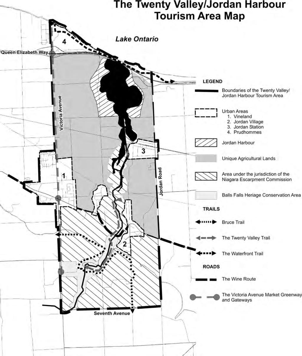
9 4.B The Twenty Valley/Jordan Harbour Tourism Area Introduction The Twenty Valley/Jordan Harbour Tourism Area is shown on The Twenty Valley/Jordan Harbour Tourism Area Map. It is expected that this Area will continue to evolve as a distinctive entity that many people will want to visit and enjoy for many purposes, in all seasons for many years to come. The Area is renowned for its combination of scenic lands and waters, world heritage natural environment, cultural heritage experiences and superb wine touring, all contained within a small and readily accessible geographic area. These features will be supported by a tourism infrastructure comprising a range of high quality food and accommodation outlets and top-notch information resources and welcoming facilities. These features will be linked by well-marked driving, cycling and walking routes. It is a goal of the Region to increase the economic benefit from tourism in the Twenty Valley/Jordan Harbour Tourism Area, while maintaining and enhancing its natural and cultural heritage resources. Further, the achievement of this goal must balance tourism interests with the existing agricultural, environmental, business and residential interests in the Area. The Twenty Valley/Jordan Harbour Tourism Area includes tourism assets in three key categories including attractions/places, linkages and open spaces and the working agricultural landscape. Attractions/Places provide the focus to the tourism strategy within the Area. They include shopping and eating areas, heritage sites and museums, waterfront attractions, market centres and wineries. These attractions/places provide the anchoring points of visitation for a network of trails and road routes that traverse the landscapes of the Area and the pastoral agricultural landscapes of the valley and lowlands. Key attractions/places within the Twenty Valley/Jordan Harbour Tourism Area include: Vineland Central Business District; Jordan Village; Jordan Station; Prudhommes; Jordan Harbour; and the Ball s Falls Heritage Conservation Area. Linkages and Open Spaces are public access routes and areas that weave through the valley and agricultural landscapes providing a system of parks trails and nature-based attractions that acknowledge the wide variety of natural and cultural amenities. The routes include linkages for hiking, cycling, car touring and water-based routes for canoes and other non-motorized vessels. The Working Agricultural Landscape offers a scenic landscape exhibiting many orchards of tender fruit, vineyards and a range of farms and agri-tourism businesses that sell products and by-products to the public including an impressive array of wineries. Farming operations provide many opportunities for public education and cottage industries of public interest. 22
10 Objectives Objective 4.B.1 The objectives related to attractions/places are: to support sensitive and compatible development within the various communities that comprise the Twenty Valley/Jordan Harbour Tourism Area; to increase the opportunities for shopping, eating and accommodation and to provide an enhanced experience of the valley and its environs for visitors; to build enhanced landscape amenities to support recreational and educational experiences; and to increase the diversity of visitation experiences for a wide range of agri-tourism and natural and cultural heritage choices, for all interests and in all seasons. Objective 4.B.2 The objectives related to linkages and open space are: to protect, manage and enhance the natural ecosystem corridors of the Niagara Escarpment, the Twenty Valley, Jordan Harbour, and the Lake Ontario waterfront and their immediate environs; to provide and enhance public access to selected natural landscape attractions, for the purposes of heritage education and scenic enjoyment, and in a manner that is not harmful to the ecology of the Area; and to promote the Area s natural assets and linkages for recreation, resource management and stewardship initiatives in an effort to improve the ecosystem for future generations. Objective 4.B.3 The objectives related to the working agricultural landscape are: to educate the visitors about the diversity of agricultural activities within the Area; to provide agri-tourism opportunities for the farming communities that will complement farming operations and the tourist appeal of the Area; to retain all Unique Agricultural Lands for specialty crops, field crops and vineyards, minimizing buildings; and to increase the enjoyment of the scenic farming landscape, and its unique natural setting. 23
11 Policies Policy 4.B.1 The Region will cooperate with the Town of Lincoln, the Niagara Peninsula Conservation Authority and other relevant agencies in planning for recreational, commercial and tourism related uses within the Twenty Valley/Jordan Harbour Tourism Area, and in providing appropriate development opportunities at key locations within it so that: development within the areas identified as Urban Areas on the Twenty Valley/Jordan Harbour Tourism Area Map maintains or enhances the visual qualities and character of the existing Villages, the connecting scenic drives and trails and protects or enhances significant natural and cultural heritage resources; the areas identified as Unique Agricultural Areas on the Twenty Valley/Jordan Harbour Tourism Area Map are protected for their ongoing use for agriculture and that the views and vistas that enhance the enjoyment of the natural environment and the agritourism potential of the Area and also protected; the area identified as Jordan Harbour on the Twenty Valley/Jordan Harbour Tourism Area Map is a sensitive environmental resource that shall be protected and enhanced; the area identified as Area under the jurisdiction of the Niagara Escarpment Commission on the Twenty Valley/Jordan Harbour Tourism Area Map including the area identified as the Ball s Falls Heritage Conservation Area shall be protected and enhanced; and any new development shall conform to all the applicable planning objectives and policies of the Region, the Town of Lincoln, the Niagara Peninsula Conservation Authority, and the Niagara Escarpment Plan. Policy 4.B.2 Policy 4.B.3 Policy 4.B.4 Policy 4.B.5 The Region will support and promote the marketing and the appropriate redevelopment of the roadways and the lands adjacent to the Wine Route and the Victoria Avenue Market Greenway. The Region will request that the Niagara Economic and Tourism Corporation include the Twenty Valley/Jordan Harbour Tourism Area in its promotional materials and activities. The Region supports the development and/or enhancement of an integrated trail system within the Twenty Valley/Jordan Harbour Tourism Area, which includes components of the Bruce Trail, the Waterfront Trail and the Twenty Valley Trail as identified conceptually on the Twenty Valley/Jordan Harbour Tourism Area Map. The identified trail network will be developed in cooperation with the Town of Lincoln, the Niagara Peninsula Conservation Authority, other public agencies and private landowners. 24
12 Policy 4.B.6 The Region, the Town of Lincoln and the Niagara Peninsula Conservation Authority shall support the development of appropriate staging areas, scenic lookouts and other complementary uses outside the Urban Areas along the trails shown on the Twenty Valley/Jordan Harbour Tourism Area Map, provided that such uses: are small in scale; are in keeping with, and complementary to the passive recreational character of the trails; have minimal impact on the surrounding public and/or private land uses; have no significant negative impacts on the natural environment or on cultural heritage resources; and will not require the extension of the municipal water supply or sanitary sewage services. Policy 4.B.7 Policy 4.B.8 Policy 4.B.9 Policy 4.B.10 The Region shall seek to secure appropriate public access where land that is owned by a public agency or a public utility is determined to be surplus to their needs and has the potential to enhance the quality and attractiveness of the trail network. The Region will encourage and support the development of other recreational trails that are connected to, and complement the Waterfront Trail and the Twenty Valley Trail. The Region will assist with funding and will cooperate with the Town of Lincoln, the Niagara Peninsula Conservation Authority and other appropriate agencies in identifying and protecting the routes for such trails. The Region requires the Town of Lincoln supported by the Niagara Peninsula Conservation Authority to identify and protect the Waterfront Trail and the uncompleted portions of the Twenty Valley Trail in its Official Plan, Zoning By-law and in all its subsequent planning decisions. The route identified for the Waterfront Trail has not been finalized and is shown conceptually on the Twenty Valley/Jordan Harbour Tourism Area Map. The Region will seek opportunities in cooperation with the Town of Lincoln and the Niagara Peninsula Conservation Authority to ensure that the Waterfront Trail, when implemented, maximizes public access to the Lake Ontario shoreline. In doing so, the Region, the Town and the Conservation Authority will take into consideration: the broad public interest in the development of a trail that provides recreational opportunities for local residents and supports tourism development; the rights of private property owners; 25
13 the protection and enhancement of sensitive natural heritage areas, agricultural areas and of local heritage resources; and shoreline protection measures may be included in area development plans for maintaining long term stability along the Lake Ontario shoreline which will assist to facilitate Smart Growth initiatives in maximizing area land use and development opportunities. Where new development is proposed on lakefront property, the Region shall support the efforts of the Town of Lincoln and the Niagara Peninsula Conservation Authority to, where publicly appropriate, secure by public ownership or by easement a strip of land along the shoreline, from the water edge to a point above the stable top-of-bank, to form part of the continuous Waterfront Trail. Policy 4.B.11 Policy 4.B.12 Portions of the route for the Twenty Valley Trail have yet to be finalized. The Region will assist with funding and will cooperate with the Town of Lincoln, the Niagara Escarpment Commission and the Niagara Peninsula Conservation Authority in determining the final routing. Adjustments to this trail route may be made by the Town without amendment to this Plan provided that the intent and purpose of this Plan and the Niagara Escarpment Plan, where applicable, are maintained. The intent of the Twenty Valley/Jordan Harbour Tourism Area Map is to identify the area where the policies of Section 4.B apply. Further, the objectives and policies of Section 4.B apply to the entire Twenty Valley/Jordan Harbour Tourism Area and are in addition to all the other applicable objectives and policies of the Region, the Town of Lincoln, the Niagara Peninsula Conservation Authority and the Niagara Escarpment Commission. 26
14 27
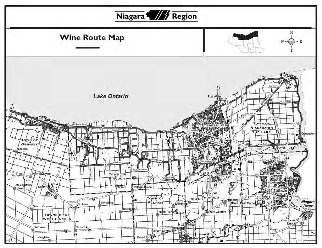
15 4.C Niagara Wine Country Introduction In 2007, the Niagara Economic Development Corporation prepared a Study entitled: Energizing Niagara s Wine Country Communities. The purpose of the Study was to develop a long term and coordinated strategy for enhancing Niagara s communities and specifically for enhancing the Wine Country communities of the Town of Grimsby, the Town of Lincoln, the City of St. Catharines, and the Town of Niagara-on-the-Lake as wine and culinary tourism destinations. The Study identified tourism development opportunities in existing communities and proposed a number of community infrastructure improvements. The Policies in this Section reflect the recommendations and overall vision in the Study and collectively are intended to: Conform with existing local municipal, Regional and Provincial Plans and policies including those of the Niagara Escarpment Commission, Support the growth of the wine industry and grape growing sectors through expanded tourism development opportunities, Support high quality community design which respects and is consistent with the character and building forms within existing communities, Support the protection and enhancement of agricultural, natural heritage, as well as cultural and historic resources throughout Niagara and within Wine Country communities. The vision, therefore, includes a thriving wine, culinary and hospitality industry, vibrant local businesses and shops, and attractive streets filled with people. The protection of cultural features, natural heritage and historic features and distinctive character of neighbourhoods and communities are not only part of the vision but central to the successful realization of the vision. The Wine Route Map shows linkages and connections through the Wine Country communities and wineries. The Wine Route map is for illustration purposes only. It is anticipated that the Wine Route will evolve and change over time as the wine industry changes and expands over time. Changes to the Wine Route map will not require an amendment to the Regional Policy Plan. The primary responsibility for identifying the Wine Route rests with the Wine Council of Ontario. However, it is expected that the Wine Council of Ontario will work with local municipalities, the Niagara Escarpment Commission, the Niagara Parks Commission and the Region when considering changes to the Wine Route. The Energizing Niagara s Wine Country Communities Study proposed a series of linked Potential Signature Developments which included the creation of a Natural Heritage Centre in Grimsby, a Marine Museum in Port Dalhousie, a Wine Country Embassy in Downtown St. Catharines, and a Wine Country Culinary Centre in Niagara-on-the-Lake. Also identified was a set of Community Development Nodes in the downtown Grimsby, Beamsville, Vineland, Jordan, downtown St. Catharines, Port Dalhousie, the Glendale Area, St. David s, Queenston, Virgil and the Old Town of Niagara-on-the-Lake. The Study identified private investment opportunities in each community such as inns, restaurants, art galleries, wine outlets etc. Decisions with respect to specific types of land uses and their location and scale will be the responsibility of the 28
16 local municipality through their Official Plans, Secondary Plans, and Community Improvement Plans. It is anticipated that the Region and local municipalities as well as other Provincial agencies such as the Niagara Escarpment Commission and the Niagara Parks Commission give consideration to the recommendations in the Energizing Niagara s Wine Country Communities Study in its planning and economic development work. Objectives Objective 4.C.1 Objective 4.C.2 Objective 4.C.3 Objective 4.C.4 Objective 4.C.5 To support high quality wine, culinary, and hospitality tourism related development within existing Wine Country Urban Areas that respects and is compatible with the character of existing communities and is consistent with local municipal, Regional and Provincial Plans and policies. To encourage the growth of agri-tourism including wine and culinary tourism. To encourage and promote a strong grape growing agricultural sector. To promote and encourage a coordinated approach to educating informing and directing visitors to the Region regarding the wine, culinary, cultural and agricultural features as well as the normal agricultural practices conducted in the area. To encourage and support appropriate and improved access by automobile and by bicycle to wineries, agri-tourism uses, cultural and historic amenities in the Region and in Wine Country. This should be based on a consultative process involving local municipalities, affected Provincial agencies and with affected local land owners. The impact on farming activities must be considered. Policies Policy 4.C.1 Policy 4.C.2 The Region will encourage local municipalities through their Official Plans and Neighbourhood Plans to identify and provide for high quality tourism related development and redevelopment opportunities within existing urban areas that are compatible with and respects the distinctive character of the communities. The Region will support a hierarchy of way finding measures including for example, traditional methods such as signage, and information kiosks, as well as perhaps less traditional GPS and GIS systems to orient, inform and direct visitors to Wine Country. The measures used should be flexible, coordinated and comprehensively designed to accommodate visitor interest in a variety of winery, culinary, cultural and historic features and using various means of travel including automobiles, bicycles and walking where appropriate. Visitors should be informed of normal farm practices conducted in the area. Agricultural practices information brochures should be made available to the public at tourist booths and other tourist outlets including bicycle rental outlets. 29
17 Policy 4.C.3 Policy 4.C.4 Policy 4.C.5 The Region will cooperate with the Wine Council of Ontario and with local municipalities and other Provincial agencies to coordinate clear and consistent signage and information centres along the Wine Route. The Region will work with and support local municipal initiatives to enhance driving and cycling opportunities along the Wine Route corridors where appropriate and in consultation with the cooperation of any affected property owners. The Region, in cooperation with local municipalities and other Provincial agencies and through the Regional Niagara Bicycling Committee and Greater Niagara Circle Route Committee will support and promote a Wine Route network and will support the provision of bicycle lanes in accordance with and as provided for on the Niagara Bicycling Network as approved in the Policy Plan. This provision is in no way intended to support the establishment of bike lanes on local and Regional roads that are not part of the approved Bicycling Network. It is recognized that the Wine Route system can be revised in the future as the wine industry changes and expands. It is expected that changes to the Wine Route by the Wine Council of Ontario would be carried out in consultation and cooperation with the Region, the local municipalities affected, and with the Niagara Escarpment Commission and the Niagara Parks Commission. Policy 4.C.6 Policy 4.C.7 Policy 4.C.8 Policy 4.C.9 The Region will pursue ways of integrating and supporting other agritourism and agricultural initiatives including the Region s Culture Plan, the Regional Culinary Trail, and Agricultural Value Added Activities policies into Wine Country programs. The intent of this policy is to complement and support these other related Regional and local municipal initiatives. Likewise, the intent of the policies is to complement other tourism and economic development initiatives and policies including the Twenty Valley/Jordan Harbour Tourism Area policies in this Plan. The Region will support and encourage local municipalities through such mechanisms as: Secondary Plans, Community Improvement Plans, heritage conservation incentives, design guidelines, redevelopment incentives, streetscape guidelines and streetscape design plans to protect cultural and heritage features and resources. The provisions contained in Policies 9.A.24 and 9.A.38 in the Transportation Section of this Plan should be considered within the context of the Wine Country Objectives. The Region in consultation with local municipalities and other Provincial agencies will provide the required infrastructure within urban areas along the Wine Route to accommodate new growth and/or redevelopment in keeping with overall infrastructure capital planning priorities, as established by Regional Council, over time. 30
18 Policy 4.C.10 Policy 4.C.11 The Region in consultation with local municipalities will support and encourage senior levels of Government to provide funding for agricultural irrigation infrastructure in Agricultural Areas. The Region will encourage and promote a strong grape growing agricultural sector by recognizing the need to conduct normal farm practices and by encouraging changes to Provincial and Federal legislation that will help identify, promote and expand the sale of VQA wine. 31
19 32
This page has been intentionally left blank.
 This page has been intentionally left blank. Chapter 2 2-2 2. Growing the Economy In many ways, the Niagara Region is a community of communities and this is becoming increasingly so. It is made up of towns
Committee. Presentation Outline
 CW-33-15 11/9/2015 Community and Corporate Services Committee November 10, 2015 1 Presentation Outline Background Vision and Objectives Study Process and Timeline Public and Stakeholder Engagement Organization
Blueways: Rivers, lakes, or streams with public access for recreation that includes fishing, nature observation, and opportunities for boating.
 Parks, Open Space and Trails PRINCE WILLIAM COUNTY 2008 COMPREHENSIVE PLAN TRAILS PLAN CONTENTS The components of the trails plan are: Intent Definitions Goals, Policies, and Action Strategies Trails Map
Update on Top 10 Issues Facing South Niagara
 Update on Top 10 Issues Facing South Niagara Presented by Mayor Dave Augustyn, Pelham Mayor Vance Badawey, Port Colborne Mayor Damian Goulbourne, Welland Mayor Barb Henderson, Wainfleet Mayor Doug Martin,
Urban Pleasures Rural Treasure
 Urban Pleasures Rural Treasure Photo credit including cover photo: Dion Kedian Welcome to Niagara-on-the-Lake, one of Canada s most scenic and majestic playgrounds nestled between the Niagara River and
SUMMER VILLAGE OF SILVER SANDS. Municipal Development Plan
 SUMMER VILLAGE OF SILVER SANDS Municipal Development Plan Bylaw 253-2014 Adopted August 22, 2014 Summer Village of Silver Sands Municipal Development Plan Bylaw No. 253-2014 Page 2 1 INTRODUCTION 1.1 SETTING
CREATING CONNECTIONS IN THE CITY OF NIAGARA FALLS PUBLIC MEETING DECEMBER 6, 2017
 CREATING CONNECTIONS IN THE CITY OF NIAGARA FALLS PUBLIC MEETING DECEMBER 6, 2017 CONGESTION COSTS OUR ECONOMY The average commute in Ontario is already over 45 minutes, and that figure jumps to more than
SENATE, No STATE OF NEW JERSEY. 217th LEGISLATURE INTRODUCED FEBRUARY 8, 2016
 SENATE, No. STATE OF NEW JERSEY th LEGISLATURE INTRODUCED FEBRUARY, 0 Sponsored by: Senator ROBERT W. SINGER District 0 (Monmouth and Ocean) Senator JOSEPH F. VITALE District (Middlesex) SYNOPSIS Establishes
County of Peterborough Active Transportation Master Plan
 The TMP developed a conceptual AT/cycling network for Peterborough County that identified both on-road and off-road (trail) AT facilities. This was a coarse network based on the existing trails and off-road
13.1 REGIONAL TOURISM ISSUES AND SUMMARY OF FINDINGS
 13 REGIONAL TOURISM T he County of Mariposa s recreation needs and facilities fall within two categories: regional tourism and local recreation. This Element focuses on regional tourism issues related
CONTENTS. 1 Introduction Always Moving Forward while Building on the Past A Dynamic Destination... 5
 2010 STRUCTURE PLAN - 2 - CONTENTS 1 Introduction... 5 1.1 Always Moving Forward while Building on the Past... 5 1.2 A Dynamic Destination... 5 2 Map A... 6 Exhibition Place and its Neighbours... 7 3 Demonstration
The Vision for the San Juan Islands Scenic Byway
 The Vision for the San Juan Islands Scenic Byway 2 Judd Cove, Orcas Island, Courtesy of Kurt Thorson (kurtthorson.com) and San Juan County Land Bank Vision for the San Juan Islands Scenic Byway The San
The Sunshine Coast is part of the global community and generates wealth through export, high-value industries and new investment.
 3.2 Strategic intent 3.2.1 Shaping growth an overview In 2031, the Sunshine Coast is renowned for its vibrant economy, ecological values, unique character and strong sense of community. It is Australia
PROJECTS. Otonabee South Monaghan. Active Transportation Master Plan Proposed Ultimate Network
 Otonabee South Monaghan Ultimate Network Otonabee-South Monaghan, located on the north shore of Rice Lake, is home to Lang Pioneer Village, Harold Town Conservation Area and numerous resorts that are major
This page has been intentionally left blank.
 This page has been intentionally left blank. 2 Appendix A List of Original Documents and s ORIGINAL DOCUMENTS: 1970-1979 By-law No. 828-785-73 as adopted on December 20, 1973 (the original 1973 Policy
Spadina Avenue Built Form Study Preliminary Report
 STAFF REPORT ACTION REQUIRED Spadina Avenue Built Form Study Preliminary Report Date: July 9, 2014 To: From: Wards: Reference Number: Toronto and East York Community Council Director, Community Planning,
SUSTAINING OUR ENVIRONMENT, PLANNING FOR OUR FUTURE
 SUSTAINING OUR ENVIRONMENT, PLANNING FOR OUR FUTURE Key Recommendations to Inform the 2015 Provincial Review of the Oak Ridges Moraine Conservation Plan APRIL 2015 KEY RECOMMENDATIONS TO INFORM THE 2015
Parkland County Municipal Development Plan Amendment Acheson Industrial Area Structure Plan
 Parkland County Municipal Development Plan Amendment Acheson Industrial Area Structure Plan New Plan Acheson Industrial Area Structure Plan Amendment Parkland County Municipal Development Plan Board Reference
2433 Dufferin Street Zoning By-law Amendment Application - Preliminary Report
 STAFF REPORT ACTION REQUIRED 2433 Dufferin Street Zoning By-law Amendment Application - Preliminary Report Date: July 22, 2014 To: From: Wards: Reference Number: North York Community Council Director,
URBAN DESIGN REPORT. Proposed Residential Development, Old Church Road, Caledon East
 Proposed Residential Development, Old Church Road, Caledon East TABLE CONTENTS: 1.0 DEVELOPMENT 1.1 Introduction-Analysis of Guiding Principles and Documents 1.2 Community Design and Architectural Design
Marchand Provincial Park. Management Plan
 Marchand Provincial Park Management Plan 2 Marchand Provincial Park Table of Contents 1. Introduction... 3 2. Park History... 3 3. Park Attributes... 4 3.1 Natural... 4 3.2 Recreational... 4 3.3 Additional
3.0 LEARNING FROM CHATHAM-KENT S CITIZENS
 3.0 LEARNING FROM CHATHAM-KENT S CITIZENS An important aspect in developing the Chatham-Kent Trails Master Plan was to obtain input from stakeholders and the general public. Throughout the course of the
The Future of the Road to Revolutions. A Battle Road Scenic Byway Public Forum November 9, 2010
 The Future of the Road to Revolutions A Battle Road Scenic Byway Public Forum November 9, 2010 Who is the Battle Road Scenic Byway? Four Towns: Arlington, Lexington, Lincoln, Concord Minute Man National
2. Goals and Policies. The following are the adopted Parks and Trails Goals for Stillwater Township:
 D. PARKS AND TRAILS 1. Introduction Stillwater Township s population is relatively low, with most residents living on rural residences on large lots. The need for active park space has been minimal in
Item No Halifax Regional Council April 10, 2018
 P.O. Box 1749 Halifax, Nova Scotia B3J 3A5 Canada Item No. 14.3.2 Halifax Regional Council April 10, 2018 TO: SUBMITTED BY: Mayor Savage and Members of Halifax Regional Council Original Signed Councillor
Land Management Summary
 photo credit: ANGAIR Anglesea Heath Land Management Summary The Anglesea Heath (6,501 ha) was incorporated into the Great Otway National Park in January 2018. This provides an opportunity to consider the
Central Alberta Destination Management Plan. CARL Presentation May 14, 2016 Sylvan Lake, AB
 Central Alberta Destination Management Plan CARL Presentation May 14, 2016 Sylvan Lake, AB Tourism in Central Alberta Understanding Central Alberta s Visitation Central Alberta DMP - Destination Overview
Building the transportation network we need for the future in Niagara Region
 Building the transportation network we need for the future in Niagara Region Niagara@metrolinx.com Metrolinx.com/Niagara Metrolinxengage.com INSERT FOOTER 1 WHO IS METROLINX? Metrolinx was created in 2006
CREATING CONNECTIONS IN THE CITY OF NIAGARA FALLS
 CREATING CONNECTIONS IN THE CITY OF NIAGARA FALLS LEON STAMBOLICH, DIRECTOR, CORRIDOR INFRASTRUCTURE ERIN MOROZ, DIRECTOR, COMMUNICATIONS AND COMMUNITY RELATIONS NIAGARA FALLS CITY COUNCIL NOVEMBER 28,
TOWN PLANNING SUBMISSION TO THE GREATER SYDNEY COMMISSION LANDS AT ARTARMON
 TOWN PLANNING SUBMISSION TO THE GREATER SYDNEY COMMISSION LANDS AT ARTARMON March 2017 TABLE OF CONTENTS 1.0 INTRODUCTION 3 2.0 THE SUBJECT SITE 4 3.0 STRATEGIC PLANNING CONTEXT 6 4.0 SUMMARY AND CONCLUSIONS
Restore and implement protected status that is equivalent, or better than what was lost during the mid-1990 s
 THE ROSSLAND RANGE, OLD GLORY AREA. Executive summary. The Friends of the Rossland Range Society, on behalf of the local outdoor community, seeks to accomplish the following with respect to the Old Glory
Chapter 6: POLICY AND PROCEDURE RECOMMENDATIONS
 Chapter 6 POLICY AND PROCEDURE RECOMMENDATIONS FOR SRRA Below are seven policy elements that should be considered for adoption by the Southwest Regional Recreation Authority of Virginia: 1. Develop strategies
Strengthening the Ontario Trails Strategy. Report on Consultations and the Environmental Bill of Rights Registry
 Strengthening the Ontario Trails Strategy Report on Consultations and the Environmental Bill of Rights Registry Purpose To report on the feedback and information received through the regional consultations,
CREATING CONNECTIONS IN THE TOWN OF GRIMSBY PUBLIC MEETING NOVEMBER 21, 2017
 CREATING CONNECTIONS IN THE TOWN OF GRIMSBY PUBLIC MEETING NOVEMBER 21, 2017 CONGESTION COSTS OUR ECONOMY The average commute in Ontario is already over 45 minutes, and that figure jumps to more than an
Bloor Street West Rezoning Application for a Temporary Use By-law Final Report
 STAFF REPORT ACTION REQUIRED 3741 3751 Bloor Street West Rezoning Application for a Temporary Use By-law Final Report Date: June 12, 2007 To: From: Wards: Reference Number: Etobicoke York Community Council
A PRIME WATERFRONT INVESTMENT OPPORTUNITY
 A PRIME WATERFRONT INVESTMENT OPPORTUNITY HAMILTON WEST HARBOUR CONTENTS 4 A Brief History of Hamilton s West Harbour 6 Hamilton s Waterfront Playground Today 10 A Vision for West Harbour 15 Engaging the
COUNTY COMPREHENSIVE PLAN
 50 : Policy Statement Lewis County has a unique and attractive rural character, which makes it a wonderful place to visit and explore. The region abounds with recreation opportunities that attract visitors
TOURISM & PUBLIC SERVICES RURAL SIGNAGE POLICY
 Policy and Procedures Subject Title: Tourism and Public Services Rural Signage Policy Corporate Policy (Approved by Council): X Policy Ref. No.: ROADS-01-07 Administrative Policy (Approved by CAO): By-Law
NOTE: YOU MAY COMPLETE THIS SURVEY ONLINE (USING THIS DOCUMENT TO VIEW MAPS AND GRAPHICS) AT:
 AT:") for completing the Town of Beech Mountain Comprehensive Planning Survey. The information you provide in reply to the following questions will be used to help the Town develop a plan that will guide our
for completing the Town of Beech Mountain Comprehensive Planning Survey. The information you provide in reply to the following questions will be used to help the Town develop a plan that will guide our
Proposal to Redevelop Lower Kananaskis River-Barrier Lake. Bow Valley Provincial Park
 Frequently Asked Questions Proposal to Redevelop Lower Kananaskis River-Barrier Lake Bow Valley Provincial Park Frequently Asked Questions What has been decided? What are the details of the plan? What
Definitions Committee on Tourism and Competitiveness (CTC)
") Definitions Committee on Tourism and Competitiveness (CTC) Since its establishment in 2013 as a subsidiary organ of the Executive Council, the Committee on Tourism and Competitiveness (CTC) has focused
Definitions Committee on Tourism and Competitiveness (CTC) Since its establishment in 2013 as a subsidiary organ of the Executive Council, the Committee on Tourism and Competitiveness (CTC) has focused
Haldimand County TRAILS MASTER PLAN and PARTNERSHIP FRAMEWORK STUDY
 Haldimand County TRAILS MASTER PLAN and PARTNERSHIP FRAMEWORK STUDY Table of Contents 1.0 INTRODUCTION...1 1.1 THE NEED FOR A TRAILS MASTER PLAN...1 1.1.1 Background and Policy Context...3 1.2 THE STUDY
Municipal and Regional District Tax Imposition Bylaw No and Metro Vancouver Letter of Support
 To: From: Re: City of Richmond General Purposes Committee Andrew Nazareth General Manager, Finance and Corporate Services Report to Committee Date: October 11, 2016 File: 08-4150-03-01/2016- Vol01 Municipal
Continental Divide National Scenic Trail Legislative History and Planning Guidance
 Continental Divide National Scenic Trail Legislative History and Planning Guidance Legislation, Policy, and Direction Regarding National Scenic Trails The National Trails System Act, P.L. 90-543, was passed
Outdoor Recreation Opportunities Management
 Outdoor Recreation Opportunities Management Introduction A major role of a management plan is to provide direction regarding the types of recreation that are appropriate, and to outline the steps that
Ontario Municipal Board Commission des affaires municipales de l Ontario
 Commission des affaires municipales de l Ontario ISSUE DATE: July 25, 2014 CASE NO: PL130788 PROCEEDING COMMENCED UNDER subsection 17(36) of the Planning Act, R.S.O. 1990, c. P.13, as amended Subject:
Municipality of West Grey
 Municipality of West Grey The Municipality of West Grey is located in southwestern Grey County, and is an amalgamation of the former Townships of Bentinck, Glenelg, Normanby, the Town of Durham and the
CORNWALL WATERFRONT PLAN 2007
 CANAL LANDS CANAL LANDS Page 58 Introduction This chapter details areas of possible development or redevelopment, and lands to be protected from any form of development in the Canal Lands area. As outlined
AGENDA ITEM 5 D WAKULLA ENVIRONMENTAL INSTITUTE (WEI) TRAIL FEASIBILITY STUDY
 TRAIL FEASIBILITY STUDY") March 19, 2018 AGENDA ITEM 5 D WAKULLA ENVIRONMENTAL INSTITUTE (WEI) TRAIL FEASIBILITY STUDY TYPE OF ITEM: Action STATEMENT OF ISSUE The Wakulla Environmental Institute (WEI) Trail is one of several trails
March 19, 2018 AGENDA ITEM 5 D WAKULLA ENVIRONMENTAL INSTITUTE (WEI) TRAIL FEASIBILITY STUDY TYPE OF ITEM: Action STATEMENT OF ISSUE The Wakulla Environmental Institute (WEI) Trail is one of several trails
CHAPTER 9. PARKS, RECREATION, TRAILS AND NATURAL AREA RESOURCES
 CHAPTER 9. PARKS, RECREATION, TRAILS AND NATURAL AREA RESOURCES The forms of recreation chosen by residents and visitors in the CBJ are as diverse as the population. Many people choose to recreate in developed
STITCH TRANSFORMATIVE IDEA 3. SHORELINE STITCH. Re-connect the city to the waterfront and link the east and west Core Circle landscapes
 SHORE STITCH TRANSFORMATIVE IDEA 3. SHORELINE STITCH Re-connect the city to the waterfront and link the east and west Core Circle landscapes 126 LINE PUBLIC WORK 127 TRANSFORMATIVE IDEA 3. SHORELINE STITCH
ANNUAL BUSINESS PLAN
 RIDEAU HERITAGE ROUTE TOURISM ASSOCIATION ANNUAL BUSINESS PLAN 2011 Aug 18, 2010 AMPLITUDE Tourism Consulting RHRTA BUSINESS PLAN 2011 1 TABLE OF CONTENTS 1.0 Executive summary 2.0 Association Profile
Town of Wasaga Beach. Official Plan Review. Commercial, Retail and Tourism Discussion Paper December 2018
 Town of Wasaga Beach Official Plan Review Commercial, Retail and Tourism Discussion Paper December 2018 Table of Contents Introduction... 1 Planning Context... 3 2.1 Location and Regional Context... 3
A CASE FOR COMPLETING THE JORDAN RIVER PARKWAY: A
 A CASE FOR COMPLETING THE JORDAN RIVER PARKWAY: A safe crossing at 9000 South and 850 West Proposed 9000 South Underpass Parkway Timeline Parkway, Trail, and Tourism Facts Blueprint Jordan River 1971 1973
LUDLAM TRAIL CORRIDOR DISTRICT
 1 APPLICATION NO. 9 MAY 2015 CDMP CYCLE LUDLAM TRAIL CORRIDOR DISTRICT PLANNING ADVISORY BOARD November 2, 2015 BACKGROUND 2 Staff Application Former Florida East Coast railroad corridor (privately owned)
communication tower means a tower or structure built to support equipment used to transmit communication signals;
 Ontario Ministry of Natural Resources Subject Communication Tower Sites on Crown Land Compiled by - Branch Lands & Waters Section Land Management Policy PL 4.10.02 Replaces Directive Title Communication
Director, Community Planning, Toronto and East York District
 STAFF REPORT October 25, 2005 To: From: : Subject: Toronto and East York Community Council Director, Community Planning, Toronto and East York District Status Report OPA & Rezoning Application 05 117524
CHAPTER 4 -- THE LAND USE PLAN: DESCRIPTIONS AND POLICIES FOR THIRTEEN PLANNING AREAS
 CHAPTER 4 -- THE LAND USE PLAN: DESCRIPTIONS AND POLICIES FOR THIRTEEN PLANNING AREAS NORTH CENTRAL CAC AREA LITTLE VALLEY ROAD TO JUG HANDLE CREEK PLANNING AREA This planning area includes Cleone, Noyo,
Westbrook Station. Transit Oriented Development Opportunity
 DEVELOPM Westbrook Station Transit Oriented Development Opportunity OPPOR Table of Contents Prime Real Estate Development Opportunity page 1 Calgary City of Opportunity page 3 What is Transit Oriented
26.2 Phipps Street Thompson Road Niagara Parkway Netherby Road. Road
 Table 9-1 Allowance Widths Town of Fort Erie Regional Number Name Segment Width in Metres 1 Dominion Gorham Lakeshore 3 Garrison Rosehill Central Avenue QEW Thompson Thompson Concession 19 Gilmore Concession
As outlined in the Tatshenshini-Alsek Park Management Agreement, park management will:
 Management Strategy General Strategy The priority management focus for the park is to ensure that its internationally significant natural, cultural heritage and recreational values are protected and that
DRAFT - APRIL 13, 2007 ROUTING STUDY FOR TRAIL CONNECTIONS BETWEEN CALAIS AND AYERS JUNCTION
 DRAFT - APRIL 13, 2007 ROUTING STUDY FOR TRAIL CONNECTIONS BETWEEN CALAIS AND AYERS JUNCTION Abstract The vision for the East Coast Greenway is an off-road urban trail system running from Calais, Maine
Mohawk Hudson Bike Hike Trail Crossroad Connection Study
 Summary Report - April 21, 2003 Mohawk Hudson Bike Hike Trail Crossroad Connection Study Summary Report Introduction The Capital District Transportation Committee (CDTC), in partnership with Albany County,
Draft Executive Summary
 Draft Executive Summary The Juneau Tourism Plan development process was undertaken by Egret Communications and ARA Consulting in April 2001, under contract with the City and Borough of Juneau, Alaska.
APPENDIX OFFICIAL MAP ORDINANCE OF HAMILTONBAN TOWNSHIP OFFICIAL MAP NARRATIVE
 APPENDIX A OFFICIAL MAP ORDINANCE OF HAMILTONBAN TOWNSHIP OFFICIAL MAP NARRATIVE INTRODUCTION: The Official Map of Hamiltonban Township has been prepared to identify those lands and features that Hamiltonban
Toronto and East York Community Council. Acting Director, Community Planning, Toronto and East York District
 STAFF REPORT ACTION REQUIRED 440, 444, 450 and 462 Front Street West; 425, 439, 441 and 443 Wellington Street West; 6-18 Spadina Ave. and 1 and 19 Draper Street Urban Design Guidelines Final Report Date:
Bayview Escarpment. Interim Management Statement
 Bayview Escarpment Interim Management Statement Bayview Escarpment Provincial Nature Reserve Interim Management Statement January 15, 1995 REGIONAL DIRECTOR'S APPROVAL STATEMENT This Interim Management
Niagara Escarpment Plan (2017)
") Niagara Escarpment Plan (2017) NIAGARA ESCARPMENT PLAN (2017) Approved by the Lieutenant Governor in Council, Order in Council No., as an amendment to the Niagara Escarpment Plan effective June 1, 2017.
Niagara Escarpment Plan (2017) NIAGARA ESCARPMENT PLAN (2017) Approved by the Lieutenant Governor in Council, Order in Council No., as an amendment to the Niagara Escarpment Plan effective June 1, 2017.
Beaver Creek Provincial Park. Management Plan
 Beaver Creek Provincial Park Management Plan 2 Beaver Creek Provincial Park Table of Contents 1. Introduction... 3 2. Park History... 3 3. Park Attributes... 4 3.1 Natural... 4 3.2 Recreational... 4 4.
Chapter 1: Introduction
 Chapter 1: Purpose of the Comprehensive Plan The purpose of the Comprehensive Plan of the City of Rockaway Beach is to provide a policy guide for the growth and future development of the City. Section
Longmont to Boulder Regional Trail Jay Road Connection DRAFT FINAL REPORT
 Longmont to Boulder Regional Trail Jay Road Connection DRAFT FINAL REPORT December 2018 Project Summary Boulder County, Colorado, in partnership with the City of Boulder, is evaluating options for multi-use
LAKE APOPKA NORTH SHORE ECO TOURISM. Strategic Action Plan 4/10/2014
 LAKE APOPKA NORTH SHORE ECO ECO-TOURISM TOURISM 4/10/2014 Strategic Action Plan The purpose of this report is to identify strategic actions for implementing a comprehensive ecotourism plan for the North
3450 Dufferin Street - Official Plan Amendment, Zoning Amendment and Draft Plan of Subdivision Applications Request for Directions Report
 STAFF REPORT ACTION REQUIRED 3450 Dufferin Street - Official Plan Amendment, Zoning Amendment and Draft Plan of Subdivision Applications Request for Directions Report Date: March 15, 2017 To: From: Wards:
PROUDLY BRINGING YOU CANADA AT ITS BEST. Management Planning Program NEWSLETTER #1 OCTOBER, 2000
 PROUDLY BRINGING YOU CANADA AT ITS BEST VUNTUT NATIONAL PARK Management Planning Program NEWSLETTER #1 OCTOBER, 2000 INTRODUCTION This newsletter launches the development of the first management plan for
Waterfront and Marina Strategic Plan. May 26, 2015 Infrastructure, Investment & Development Committee
 Waterfront and Marina Strategic Plan May 26, 2015 Infrastructure, Investment & Development Committee 1 Purpose Background Update work completed or underway Vision & principles Balanced plan with opportunities
Ouimet Canyon Provincial Nature Reserve. Management Plan
 Ouimet Canyon Provincial Nature Reserve Management Plan NOTE: This document has been scanned and formatted, and therefore is slightly different from the original version. -March 2002 Additional copies
Directional Tourism Signage Programme Policies
 Directional Tourism Signage Programme Policies Introduction Directional tourism signage also known as a pay-to-play programme provides an opportunity for tourism attractions and tourism-based businesses
2.1 TITLE: VMC PARKS MASTER PLAN AND IMPLEMENTATION STRATEGY PROJECT UPDATE
 2.1 Item: VMC Sub-committee Report DATE: Tuesday, June 12, 2018 WARD: 4 TITLE: VMC PARKS MASTER PLAN AND IMPLEMENTATION STRATEGY PROJECT UPDATE FROM: Jason Schmidt-Shoukri, Deputy City Manager, Planning
CHAPTER FIVE PROSPECTS FOR FUTURE ECONOMIC DEVELOPMENT
 CHAPTER FIVE PROSPECTS FOR FUTURE ECONOMIC DEVELOPMENT 5.1 GENERAL The recommended type and location of future land uses in Alpine should, in part, consider potential opportunities for future economic
PARKLAND COUNTY TOURISM ACTION PLAN
 PARKLAND COUNTY TOURISM ACTION PLAN 2018-2020 CONTENTS Introduction............................................... 05 Organizational Alignment.................................. 07 Action Plan Development..................................
This Executive Summary highlights the results of a multi-year planning process and includes recommendations of the New Jersey Trails Plan.
 Purpose and Scope The New Jersey Trails Plan presents a renewed vision, goals and strategic actions to help guide the efforts of all those who plan, build, operate and maintain New Jersey s trails. Building
Te Kowhai COMMUNITY PLAN
 1 2011-2021 Te Kowhai COMMUNITY PLAN Vision To realise a lifestyle potential 2 Map of Te Kowhai area 3 4 History of the plan In 2004 the Te Kowhai Community Group Committee and the residents put together
RUSHMORE CONNECTOR TRAIL PROPOSAL
 PURPOSE AND NEED Background The U.S. Forest Service, Black Hills National Forest (Forest Service) has received a special use permit application from the State of South Dakota Department of Game, Fish and
REGIONAL BOARD REPORT
 REGIONAL BOARD REPORT Administrator s Office For the Board August 21, 2008 DATE: August 14, 2008 FILE NOS.: A-07-06377/8/9.000 FROM: RE: Chief Administrative Officer OCP and Zoning Amendment Application
Trappist Monastery Provincial Park. Management Plan
 Trappist Monastery Provincial Park Management Plan 2 Trappist Monastery Provincial Park Table of Contents 1. Introduction... 3 2. Park History... 3 3. Park Attributes... 4 3.1 Natural... 4 3.2 Recreational...
PERFORMANCE INDICATORS
 PERFORMANCE INDICATORS for the greenbelt plan Part 1, 2015 Ontario.ca/mah PERFORMANCE INDICATORS for the greenbelt plan Part 1, 2015 TABLE OF CONTENTS Page Welcome to Greenbelt Plan Performance Indicators
Birch Point Provincial Park. Management Plan
 Birch Point Provincial Park Management Plan 2 Birch Point Provincial Park Table of Contents 1. Introduction... 3 2. Park History... 3 3. Park Attributes... 4 3.1 Natural... 4 3.2 Recreational... 4 4. Park
CREATING CONNECTIONS IN THE CITY OF ST. CATHARINES
 CREATING CONNECTIONS IN THE CITY OF ST. CATHARINES LEON STAMBOLICH, DIRECTOR, CORRIDOR INFRASTRUCTURE BRIAN GALLAUGHER, DIRECTOR, PROJECT PLANNING RER ST. CATHARINES CITY COUNCIL NOVEMBER 13, 2017 A REGION
Boyne Valley Provincial Park. Interim Management Statement
 Boyne Valley Provincial Park Interim Management Statement January 20, 1995 REGIONAL DIRECTOR'S APPROVAL STATEMENT This Interim Management Statement will provide interim direction for the management of
F6. Coastal Ferry Terminal Zone
 F6. Coastal Ferry Terminal Zone F6.1. Zone description The purpose of the Coastal Ferry Terminal Zone is to provide for the integrated and efficient operation and development of ferry terminal facilities.
Watchorn Provincial Park. Management Plan
 Watchorn Provincial Park Management Plan 2 Watchorn Provincial Park Table of Contents 1. Introduction... 3 2. Park History... 3 3. Park Attributes... 3 3.1 Natural... 4 3.2 Recreational... 4 3.3 Additional
Establishing a National Urban Park in the Rouge Valley
 STAFF REPORT ACTION REQUIRED Establishing a National Urban Park in the Rouge Valley Date: March 29, 2012 To: From: Wards: Reference Number: Executive Committee Deputy City Manager, Cluster B All p:\2012\cluster
Cavan Monaghan Trail Master Plan. Prepared by Otonabee Conservation for The Township of Cavan Monaghan
 Cavan Monaghan Trail Master Plan Prepared by Otonabee Conservation for The Township of Cavan Monaghan June 2010 Acknowledgements Thank you to the following individuals and organizations for their assistance
Martinez General Plan 2035 White Paper TRAILS
 Martinez General Plan 2035 White Paper TRAILS November 2016 The Issue The draft Martinez General Plan 2035 and Draft Program Environmental Impact Report were released for public review on September 15,
CHAPTER 13 Tourism and Recreation. Kildare County Development Plan , Volume 1
 Chapter 6 Rural Housing Strategy CHAPTER 13 Tourism and Recreation 197 13 TOURISM AND RECREATION 13.1 Background 13.2 Goal Tourism is one of the growth sectors in our economy. Kildare is rich in natural
2013 Priority Initiatives March 19, 2013
 2013 Niagara County Economic Development Address 2013 Priority Initiatives March 19, 2013 Kathryn L. Lance, Chair Niagara County Economic Development Committee 1 WNY Regional Economic Development Council
Flow Stand Up Paddle Board Parkway Plan Analysis
 Regional Parks Department Jeffrey R. Leatherman, Director County of Sacramento Divisions Administration Golf Leisure Services Maintenance Rangers Therapeutic Recreation Services Flow Stand Up Paddle Board
Nakina Moraine Provincial Park. Interim Management Statement. Ontario. Ministry of Natural Resources
 Nakina Moraine Provincial Park Interim Management Statement Ontario Ministry of Natural Resources 1999, Queen's Printer for Ontario Printed in Ontario, Canada Additional copies of this publication can
Washington Township MASTER PLAN. Addendum: Washington Township Master Plan
 Washington Township MASTER PLAN Addendum: Washington Township Master Plan CHAPTER XI RECREATION CORE DISTRICT Introduction The Recreation Core District generally encompasses the areas north of 30 Mile
PSP 75 Lancefield Road. Northern Jacksons Creek Crossing Supplementary Information
 PSP 75 Lancefield Road Northern Jacksons Creek Crossing Supplementary Information September 2017 The northern crossing of Jacksons Creek proposed within the Lancefield Road PSP is a key part of the ultimate