The Transportation Corridor Overlay District
|
|
|
- Melvyn Gregory
- 5 years ago
- Views:
Transcription
1 The Transportation Corridor Overlay District The Transportation Corridor Overlay District is a policy framework under which certain potentially beneficial development proposals may be considered, given their proximity to improved transportation access. The creation of the Transportation Corridor Overlay District is based upon certain fundamental issues. 1) Transportation improvements will create a catalyst for development. The Transportation Corridor Overlay District will attempt to manage growth that will occur along transportation improvements. 2) The City should preserve future opportunities for economic development. The Transportation Corridor Overlay District creates a policy of preserving highly visible, highly accessible sites for economic development purposes. This will ultimately serve the public welfare by increasing tax revenues and employment opportunities. 3) These corridors are highly visible and any proposal contained therein should reflect good building and site design practices. The Transportation Corridor Overlay District provides design guidelines for development throughout the corridor.
2 The Study Area For purposes of this study, the corridors of Route 104 (Great Bridge Boulevard to George Washington Highway) and Route 168 (the Chesapeake Expressway from Hillwell Road to the North Carolina State Line) are being recommended as Transportation Corridor Overlay Districts. Properties affected by the policy include all land that falls within a one-mile (5,280 feet) buffer around each of these road segments. In the event the Corridor boundary bisects a parcel, only that portion within the boundary is included in the study. If at least 50% (one-half) of a parcel is included in the Corridor, then, at the option of the property owner, the guidelines resulting from this policy may extend to the remaining portion of the parcel. A one-mile buffer was selected because it is reflective of both City and HRSD policy regarding the service areas for sewer force mains. The one-mile buffer is further preferred because of 1) the ability to geographically accommodate larger scale development, and 2) the ability to extend the protection of the policy throughout the corridor. While only the Route 104 and Route 168 Corridors are under consideration at this time, other corridors may be considered in the future.
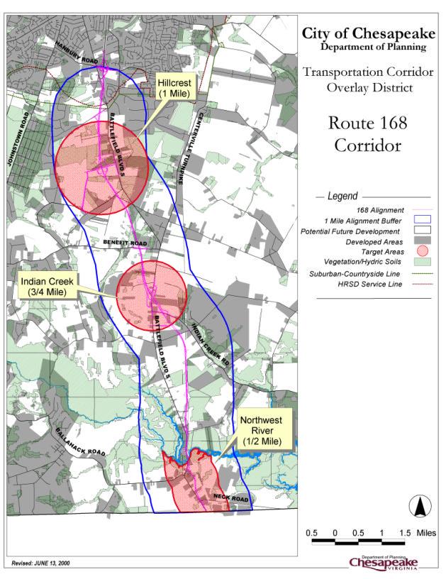
3 Route 168 Corridor The Route 168 corridor is the major linkage between Hampton Roads and the Outer Banks of North Carolina. Construction of the new Chesapeake Expressway has begun with an anticipated completion in the summer of The Chesapeake Expressway will be a four lane limited access highway. Interchanges for the new expressway will be located at Hillcrest Parkway, Indian Creek Road, and at Battlefield Boulevard at the Northwest River. A toll will be charged for the segment between Hillcrest Parkway and the Northwest River. The area under review is 9.7 miles long and extends along the Chesapeake Expressway alignment from the North Carolina State line north to the area parallel to Hillwell Road. Areas to the north of the corridor are generally saturated with residential development. The Corridor is primarily rural in nature with a small business cluster at Hickory (intersection of Battlefield Boulevard and Centerville Turnpike) and near the State line. A few small businesses dot Battlefield Boulevard. The majority of land in this corridor is zoned A-1 Agricultural District. The majority of the land in this corridor falls under the Rural Overlay District provisions of the Chesapeake Zoning Ordinance, which promotes lower density development. 1,195 new residential units were constructed in this corridor over the past ten years.
4
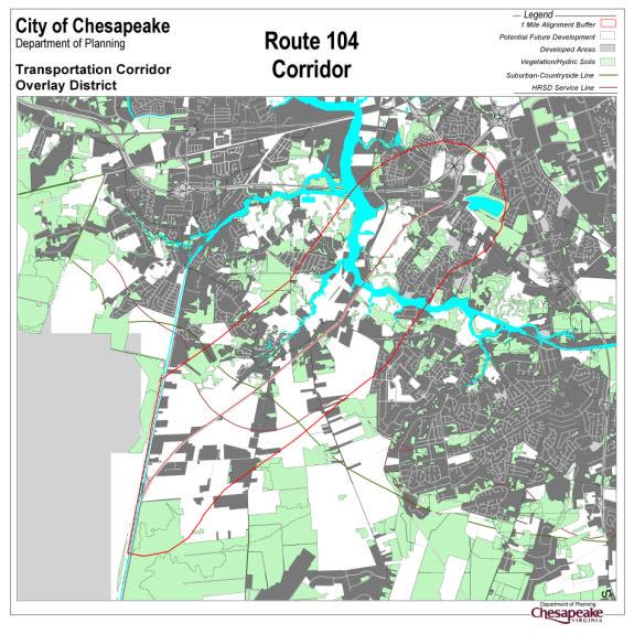
5 Route 104 The Route 104 / Dominion Boulevard corridor connects Interstate 464 and Interstate 64 to Route 17 / George Washington Highway. This study examines a 6.7-mile segment from Great Bridge Boulevard to George Washington Highway. The roadway is currently a two-lane undivided highway with a draw span bridge (the Steel Bridge) at the Southern Branch of the Elizabeth River. Significant intersections along the roadway include Great Bridge Boulevard, Bainbridge Boulevard, Cedar Road, Shillelagh Road, and West Road. The Route 104 / Dominion Boulevard corridor is a significant north south linkage. Traffic on U.S. Route 17 is directed to Route 104 to connect into the interstate highway system. The corridor has been designated as the future Raleigh to Norfolk Connector. A feasibility study was recently completed for this corridor and has recommended that the facility be improved to a limited access arterial south of Cedar Road and a limited access freeway north to I-464. The areas north of the Steel Bridge are mostly developed. Areas to the west along the Southern Branch of the Elizabeth River are heavy, waterfront industrial and have been identified as underutilized areas. Areas to the east are rapidly developing as residential. Development south of the Steel Bridge extends to the Cedar Road corridor, which is one of the most rapidly developing residential corridors in the City. Plans for a shopping center were recently approved at the intersection of Cedar Road. Undeveloped areas begin just south of the Cedar Road intersection. These areas are predominately zoned A-1 Agricultural District with the exception of some R-15 Residential District zoning along the road frontages of Shillelagh and West Roads. Residences intermittently line Shillelagh and West Roads. The limits of current planning for this corridor ends just south of the Cedar Road intersection where the Countryside and Suburban Overlay District boundaries converge. 2,360 new residential units have been built in the corridor over the past decade, which represents 14.5% of the City s new residential growth.
6
7
A. From I-68 in Monongalia County, West Virginia to SR 6119 in Fayette County, Pennsylvania 1
 Mon-Fayette Transportation Project A. From I-68 in Monongalia County, West Virginia to SR 6119 in Fayette County, Pennsylvania 1 The Mon/Fayette Transportation Project (MFTP) from I-68 in West Virginia
Building for the Future: a Corridor of Possibility
 Building for the Future: a Corridor of Possibility Annual Report 2017 Letter from the Mayor Alan P. Krasnoff With $289 million in business investments and nearly 1,300 new jobs, 2016 was another record-breaking
Section 106 Update Memo #1 Attachment D. Traffic Diversion & APE Expansion Methodology & Maps
 Section 106 Update Memo #1 Attachment D Traffic Diversion & APE Expansion Methodology & Maps I-65/I-70 North Split Interchange Reconstruction Project (Des. Nos. 1592385 & 1600808) Traffic Diversion and
WASHINGTON TOWNSHIP REGIONAL ANALYSIS
 WASHINGTON TOWNSHIP REGIONAL ANALYSIS SECTION 1.0 INTRODUCTION The growth and development of a community and its resultant land use pattern depends, in large part, on its position within the region in
CHAPTER 4 -- THE LAND USE PLAN: DESCRIPTIONS AND POLICIES FOR THIRTEEN PLANNING AREAS
 CHAPTER 4 -- THE LAND USE PLAN: DESCRIPTIONS AND POLICIES FOR THIRTEEN PLANNING AREAS NORTH CENTRAL CAC AREA LITTLE VALLEY ROAD TO JUG HANDLE CREEK PLANNING AREA This planning area includes Cleone, Noyo,
Parkland County Municipal Development Plan Amendment Acheson Industrial Area Structure Plan
 Parkland County Municipal Development Plan Amendment Acheson Industrial Area Structure Plan New Plan Acheson Industrial Area Structure Plan Amendment Parkland County Municipal Development Plan Board Reference
Union Square. & Park Place. Project Summary Submitted by DeHoff Development Company
 Union Square & Park Place Submitted by DeHoff Development Company December 18, 2012 encompass a 250-acre, mixed-use corporate campus that includes office, hotel, retail and residential components. The
FNORTHWEST ARKANSAS WESTERN BELTWAY FEASIBILITY STUDY
 FNORTHWEST ARKANSAS WESTERN BELTWAY FEASIBILITY STUDY EXECUTIVE SUMMARY The 2030 Northwest Arkansas Regional Transportation Plan developed by the Northwest Arkansas Regional Planning Commission (NWARPC)
PURPOSE AND NEED (CONCURRENCE POINT 1) NEW CANADA ROAD PROJECT FROM STATE ROUTE 1 (U.S. HIGHWAY 70) TO U.S. INTERSTATE 40
 NEW CANADA ROAD PROJECT FROM STATE ROUTE 1 (U.S. HIGHWAY 70) TO U.S. INTERSTATE 40") PURPOSE AND NEED (CONCURRENCE POINT 1) NEW CANADA ROAD PROJECT FROM STATE ROUTE 1 (U.S. HIGHWAY 70) TO U.S. INTERSTATE 40 Project Description The primary purpose of this project is to improve the major
PURPOSE AND NEED (CONCURRENCE POINT 1) NEW CANADA ROAD PROJECT FROM STATE ROUTE 1 (U.S. HIGHWAY 70) TO U.S. INTERSTATE 40 Project Description The primary purpose of this project is to improve the major
Gardner: overview. Santa Fe, Oregon, and California National Historic Trails UNINCORPORATED JOHNSON COUNTY OLATHE UNINCORPORATED JOHNSON COUNTY
 Santa Fe, Oregon, and California ational Historic Trails : overview 99: p.134 100: p.135 GARDER JUCTIO 102: p.137 56: p.126 EDGERTO Burlington orthern Intermodal and Logistics 98: p.133 101: p.136 S Waverly
Project Location. Connects I-10 in Duval County to I-95 in St. John County Four lane limited access toll facility. Jacksonville
 First Coast Outer Beltway August 2012 Project Location DUVAL Jacksonville First Coast Outer Beltway CLAY ST. JOHNS Connects I-10 in Duval County to I-95 in St. John County Four lane limited access toll
1.2 Corridor History and Current Characteristics
 SECTION 1 Description and Background of Study Area 1.1 Introduction This preliminary engineering report was prepared for the Alaska Department of Transportation and Public Facilities (ADOT&PF). It is part
CAPITAL IMPROVEMENT PLAN FOR THE FIVE YEAR PERIOD ENDING JUNE 30, 2022 ALLOCATION OF RESOURCES
 Cash - GF Transfer Athletic Field Improvements 16-190 - - - - - - 660,000-660,000 Deep Creek AIW Bridge Replacement 08-180 - - - - - - 500,000-500,000 Elizabeth River Park Fishing Pier 19-191 - - - - -
State Route 8 Corridor. Northern Summit County s Path to Success
 State Route 8 Corridor Northern Summit County s Path to Success Construction Guide: 2008-2009 State Route 8 corridor work description State Route 8 Corridor 10 projects $262 million With its close proximity
I-75 in Hamilton County Project Termini
 I-75 in Hamilton County Project Termini Introduction As part of the North South Transportation Initiative (NSTI), capacity improvements were recommended for the I-75 corridor through Hamilton County from
THREE MILE PLAN TOWN OF SUPERIOR COLORADO
 THREE MILE PLAN TOWN OF SUPERIOR COLORADO February 23, 2015 INTRODUCTION This document has been prepared by the Town of Superior, Colorado, to address the existing and proposed land uses within an approximate
5.0 Study Area Inventory & Trail Alternatives. 5.1 Photographic Overview of Study Area
 39 5.0 Study Area Inventory & Trail Alternatives Previous sections of this study contain physical, social, and regulatory information for the Crosswicks Creek/Doctors Creek watershed and the smaller Doctors
SUPPORT THE ROUTE 58 PPTA: A Good Investment in Virginia
 Project Profile: SUPPORT THE ROUTE 58 PPTA: A Good Investment in Virginia In 1989, the General Assembly established the Route 58 Corridor Development Program to enhance economic development potential across
Community Facilities ADA Door & Restroom Retrofits at Various Facilities - Phase I
 Community Facilities ADA Door & Restroom Retrofits at Various Facilities - Phase I 21-200 - - - - - - ADA Facility and Infrastructure Retrofits 01-220 50,000 50,000 50,000 50,000-200,000 CIBH - Parking
Major Projects Overview
 Major Projects Overview Miami-Dade Expressway Authority February 2018 About MDX MDX operates 5 roads in Miami Dade County SR 924, SR 112, SR 836, SR 874 and SR 878 MDX Primary Source of Revenue: User Fees-Tolls
SOUTHERN BELTWAY I-79 TO MON/FAYETTE EXPRESSWAY
 SOUTHERN BELTWAY I-79 TO MON/FAYETTE EXPRESSWAY Section 1 Purple Alternative (Revised: January 2007) I-79 to Mon/Fayette Expressway Purple Alternative Section 1 Photo Presentation Photo Presentation The
Mission Statement. Spur 601 Project Highlights
 Mission Statement SPUR 601 is a TxDOT project dedicated to provide a safe, efficient, reliable new corridor to improve the mobility in east-central El Paso. The SPUR 601 team is working in partnership
Community Development Committee
 C Community Development Committee For the Metropolitan Council meeting of October 31, 2012 Committee Report Item:2012-316 ADVISORY INFORMATION October 16, 2012 Date Prepared: Subject: Intercity Regional
SR 429/WEKIVA PARKWAY FTBA CONFERENCE March 20-21, Presented By Suzanne Phillips, P.E., FDOT District 5
 SR 429/WEKIVA PARKWAY FTBA CONFERENCE March 20-21, 2012 Presented By Suzanne Phillips, P.E., FDOT District 5 Project Description The Wekiva Parkway project constructs 25 centerline miles of new toll expressway.
DULLES AREA HIGHLIGHTS. Gary Garczynski Commonwealth Transportation Board Northern Virginia District. Committee for Dulles August 4, 2016
 DULLES AREA HIGHLIGHTS Gary Garczynski Commonwealth Transportation Board Northern Virginia District Committee for Dulles August 4, 2016 Smart Scale (formerly HB2) Overview Round 1 completed with the adoption
Other Principle Arterials Minor Arterial Major Collector Minor Collector Local
 CHAPTER 10 TRANSPORTATION Introduction The system of public roads in East Pikeland Township is decidedly rural in character. Since the 1984, the road network has remained much the same, with the addition
Aviation, Rail, & Trucking 6-1
 6-1 This chapter describes the services, facilities, and condition of air, rail, and trucking as components of the transportation system. These three intermodal areas have an impact on the factors to be
Road Construction Ahead January-April 2015 NORTHWEST REGION
 NORTHWEST REGION 1 Interstate 64 Augusta, Nelson, Albemarle counties: Installing communications conduit in median for active traffic management system on Afton Mountain. Periodic left-shoulder closures,
CAPITAL IMPROVEMENT PLAN FOR THE FIVE YEAR PERIOD ENDING JUNE 30, 2023 ALLOCATION OF RESOURCES. Cash - General Fund Transfer Total
 Cash - General Fund Transfer Cash - General Fund Transfer Total - - - - - - Cash - Greenbrier TIF Intersection Improvements: Battlefield Blvd. at Volvo Pkwy. 40-230 125,000 550,000 - - - 675,000 Right
Figure San Dimas Bonita at San Dimas Avenue (view looking west)
") The adjoining neighborhood has an eclectic assortment of building types and uses, including: the historically significant but not architecturally or visually noteworthy San Dimas Lemon Association Packing
The adjoining neighborhood has an eclectic assortment of building types and uses, including: the historically significant but not architecturally or visually noteworthy San Dimas Lemon Association Packing
35EXPRESS PROJECT UPDATE FOR DENTON COUNTY COMMISSIONERS
 35EXPRESS PROJECT UPDATE FOR DENTON COUNTY COMMISSIONERS 35EXPRESS PROJECT OVERVIEW 2 ABOUT THE 35EXPRESS PROJECT 3 DESIGN-BUILD TEAM 4 PROJECT PARTNERS Great partnerships make this project work Collaboration
Draft Concept Alternatives Analysis for the Inaugural Airport Program September 2005
 Section 10 Preferred Inaugural Airport Concept 10.0 Introduction The Preferred Inaugural Airport Concept for SSA was developed by adding the preferred support/ancillary facilities selected in Section 9
Part Three : COMMUNITY PLAN AREAS AND SPECIAL STUDY AREAS SACRAMENTO 2030 GENERAL PLAN. Introduction
 Special study Areas Part Three : COMMUNITY PLAN AREAS AND SPECIAL STUDY AREAS SACRAMENTO 2030 GENERAL PLAN Introduction Beyond the boundaries of the 2030 General Plan, the City has defined Special Study
Basic Project Information
 FY 2015-16 PROJECT DESCRIPTION FORM (2C) Submitting Agency: Loudoun County Basic Project Information Project Title: Loudoun County Parkway (VA Route 607) U.S. 50 to Creighton Rd. (2C) Project Type (check
APPENDIX OFFICIAL MAP ORDINANCE OF HAMILTONBAN TOWNSHIP OFFICIAL MAP NARRATIVE
 APPENDIX A OFFICIAL MAP ORDINANCE OF HAMILTONBAN TOWNSHIP OFFICIAL MAP NARRATIVE INTRODUCTION: The Official Map of Hamiltonban Township has been prepared to identify those lands and features that Hamiltonban
DESCRIPTION. 2,326± acres ROAD FRONTAGE. 10,940 ± on N side of Florida s Turnpike 2,620 ± on E side of CR 468
 FLORIDA'S TURNPIKE DESCRIPTION Located in close proximity to The Villages, the country s fastest-growing (3,419 sales in 2013) and largest single-site real estate development, which boasts 33 golf courses,
PROPOSED ALTERATION AND EXPANSION OF THE MOUNT PEARL MUNICIPAL BOUNDARY TO INCLUDE THE AREA OF THE FORMER PEARL ESTATE LANDS & ENVIRONS
 PROPOSED ALTERATION AND EXPANSION OF THE MOUNT PEARL MUNICIPAL BOUNDARY TO INCLUDE THE AREA OF THE FORMER PEARL ESTATE LANDS & ENVIRONS JANUARY 4, 2007 INTRODUCTION In accordance with Sections 3 to 6 inclusive
AGENDA ITEM 5 D WAKULLA ENVIRONMENTAL INSTITUTE (WEI) TRAIL FEASIBILITY STUDY
 TRAIL FEASIBILITY STUDY") March 19, 2018 AGENDA ITEM 5 D WAKULLA ENVIRONMENTAL INSTITUTE (WEI) TRAIL FEASIBILITY STUDY TYPE OF ITEM: Action STATEMENT OF ISSUE The Wakulla Environmental Institute (WEI) Trail is one of several trails
March 19, 2018 AGENDA ITEM 5 D WAKULLA ENVIRONMENTAL INSTITUTE (WEI) TRAIL FEASIBILITY STUDY TYPE OF ITEM: Action STATEMENT OF ISSUE The Wakulla Environmental Institute (WEI) Trail is one of several trails
Florida Department of TRANSPORTATION. First Coast Expressway
 Florida Department of TRANSPORTATION First Coast Expressway What is the (FCE)? Multi-lane, limited access toll expressway Connects I-10 in Duval County to I-95 in St. Johns County How does FCE connect
Airport Planning Area
 PLANNING AREA POLICIES l AIRPORT Airport Planning Area LOCATION AND CONTEXT The Airport Planning Area ( Airport area ) is a key part of Boise s economy and transportation network; it features a multi-purpose
Southern Beltway Projects Summary
 Southern Beltway Projects Summary The Pennsylvania Turnpike Commission is proposing the construction of a 30-mile, tolled fourlane limited-access highway, known as the Southern Beltway that will be located
NWC Hwy 85 & 42 nd Street Evans, Colorado
 NWC Hwy 85 & 42 nd Street Evans, Colorado 13.9 Acre Site Build to Suit Gas / Convenience Store Sites from $250,000.74 to 7.38 Acre Commercial / Industrial Sites N PLATTED SITES AVAILABLE: All, part, and
FEASIBILITY CRITERIA
 This chapter describes the methodology and criteria used to evaluate the feasibility of developing trails throughout the study areas. Land availability, habitat sensitivity, roadway crossings and on-street
This section evaluates the projected traffic operations and circulation impacts associated with the proposed upgrade and expansion of the LWRP.
 4.5 TRAFFIC AND CIRCULATION This section evaluates the projected traffic operations and circulation impacts associated with the proposed upgrade and expansion of the LWRP. 4.5.1 Environmental Setting Existing
HAMPTON ROADS CROSSINGS PATRIOTS CROSSING AND HRBT
 HRTPO Board Meeting March 21, 2013 Agenda ITEM #9: HAMPTON ROADS CROSSINGS PATRIOTS CROSSING AND HRBT Congestion at the Hampton Roads Bridge-Tunnel (HRBT) on I-64 has long been identified as a problem
Presented By: Deputy Executive Director February 17, 2011
 TRANSPORTATION PROJECT PRIORITIZATION Presented By: Camelia Ravanbakht, Ph.D. Ca e a aaba t,.. Deputy Executive Director February 17, 2011 OVERVIEW 2034 Long-Range g Transportation Plan (LRTP) Process
Kilometres. Blacktown. Penrith. Parramatta. Liverpool Bankstown. Campbelltown
 0 5 10 15 20 Kilometres Penrith Blacktown Parramatta Liverpool Bankstown Campbelltown accessibility outcomes Legend Outcomes targeted in Western Sydney are: public transport that is accessible throughout
TRANSPORTATION. Reston Market Profile
 Reston Market Profile TRANSPORTATION Fairfax County Background A recent TIME Magazine featured rapidly growing Fairfax County as one of four "megacounties" in the nation-suburban counties that have outgrown
Human Environment. 2.1 Land Use
 Human Environment 2.1 Land Use This section is a summary of the analysis documented in the Community Impact Assessment (CIA) prepared for this project (ICF International 2014a). The report is available
TRAFALGAR PARK. 78: p.140 W 99th St FLAT ROCK CREEK PARK. W 103rd St OVERLAND PARK. Quivira Rd. College Blvd. Shared use path. Mountain bike trail
 Lenexa: overview TRAFALGAR PARK 78: p.140 As the Westport Route crosses over Lenexa's boundaries with Olathe and Overland Park several times, approximately 2.75 or 3 miles of the historic route of the
Town of Oakfield Agricultural and Farmland Protection Plan
 SECTION III COMMUNITY OVERVIEW A. Regional Setting / Location The Town of Oakfield is located in the northwestern portion of Genesee County. Located west of New York's Finger Lakes, the Town is uniquely
Sundance Square. Liberty Hill, Texas 78642
 RETAIL / OFFICE DEVELOPMENT OPPORTUNITY Bulk Sale of ±24 Acres at $4.00 / sq. ft. Existing Williamson CAD Tax Parcels Property Features Area of high residential development growth Situated at the entrance
A number of goals were identified during the initial work on this Big Lake Transportation Plan.
 C. Transportation General Background Information Big Lake s transportation system includes all the roads, paths and facilities that allow the movement of private vehicles, trains and planes, as well as
north GREENFIELD parkway Garner, North Carolina
 BULK build-to-suit north GREENFIELD parkway Garner, North Carolina FEATURES & SITE PLAN 250,000 SF BUILDING BUILDING SIZE 250,000 SF AVAILABLE SF 250,000 SF CLEAR HEIGHT 30' - 32' COLUMN SPACING Designed
Draft 2040 LRTP Candidates
 Ballahack Defense Access s Route 17 Old Battlefield s Centerville Turnpike Mount Pleasant VA Beach City Line Widening and Airport Access West Route 17 alignment Light Rail Existing LRT LRT Extension Survey
2008 DEKALB COUNTY TRANSPORTATION PLAN (UPDATE)
") 2008 DEKALB COUNTY TRANSPORTATION PLAN (UPDATE) TABLE OF CONTENTS Introduction 1 Transportation Planning Activities 2 Identification of Problem Areas and Recommended Solutions 7 DeKalb County Projects
2008 DEKALB COUNTY TRANSPORTATION PLAN (UPDATE) TABLE OF CONTENTS Introduction 1 Transportation Planning Activities 2 Identification of Problem Areas and Recommended Solutions 7 DeKalb County Projects
Leasing Brochure. Park Plaza Shopping Center 1150 N. Federal Highway, Pompano Beach, Florida Under Construction - Coming Very Soon
 Park Plaza Shopping Center 1150 N. Federal Highway, Pompano Beach, Florida 33062 Leasing Brochure Under Construction - Coming Very Soon Exclusive Leasing Broker 2048 East Sample Road, Lighthouse Point,
Coast to Coast Connector Summit
 Project Partners Welcome to the Coast to Coast Connector Summit Winter Garden, Florida City Hall October 1, 2014 1 Why are we here? Objectives 1. Inform key stakeholders on the current state of the C2C
4. Safety Concerns Potential Short and Medium-Term Improvements
 NH Route 104 Access Management Study Page 19 4. Safety Concerns Potential Short and Medium-Term Improvements Potential safety improvement strategies are listed by priority based on field observations by
2.6 BUILD ALTERNATIVE OPTIONS
 2.6 BUILD ALTERNATIVE OPTIONS As set forth in a 21 June 2001 Resolution of the CTB, with approved amendments by the CTB on 15 July 2004, the Adopted Location Corridor (ALC) proposed alignment, would extend
Transportation TRANSPORTATION PROJECTS
 Transportation TRANSPORTATION PROJECTS Balls Ford Road Interchange Total Project Cost $142.9M This project includes the construction of a new diverging diamond interchange at Route 234 Bypass (Prince William
Tinker Air Force Base, Oklahoma
 Table 5.4 Generalized Zoning within the Tinker AFB Clear Zones and Accident Potential Zones (Off-Installation) Category Acreage Residential 1,486 Commercial 191 Industrial 128 Public/Quasi-public 0 Recreational/Open/Agricultural/Low
Site Location and Setting
 Memorandum Date: To: From: Subject: Kristy Le, Gary Black Steve Orem Santa Teresa County Park Historic Area Traffic and Parking Study Hexagon Transportation Consultants, Inc. has completed a traffic and
A RESOLUTION NOW, THEREFORE, BE IT RESOLVED BY THE CITY COUNCIL OF THE CITY OF EL PASO THAT:
 A RESOLUTION EXPRESSING THE CITY OF EL PASO S INTENT TO CREATE TRANSPORTATION REINVESTMENT ZONE NO. 1 TO FINANCE TRANSPORTATION PROJECTS IN SUPPORT OF THE COMPREHENSIVE MOBILITY PLAN FOR EL PASO; SETTING
SOUTH INTERCHANGE AREA
 Santaquin City General Plan 1 Location and Characteristics The South Interchange Area of Santaquin is located west of Interstate 15 and south of 500 South (Figure 1). It includes properties already annexed
FY TRANSPORTATION IMPROVEMENT PROGRAM. Authority Projects FY
 Brewster Road Widening and North Avenue Bridge PA04009 This project will provide for the widening of Brewster Road at the south end of the airport as well as the replacement and realignment of the North
9.4 Acres Commercial Land Interstate 70 at Strasburg, CO
 9.4 Acres Commercial Land Interstate 70 at Strasburg, CO $895,000 This parcel is well-situated at the Strasburg exit with frontage road access and excellent visibility from I-70. It is suited for a variety
Salisbury's Destination Business Park!
 Unique and desirable Planned Development District zoning allows for many uses: Retail Professional Restaurant Hotel Medical Frontage, access & visibility on Three Major Thoroughfares: US Rt. 50 St. Hwy
Executive Summary Project Overview Physical Context Strategic Context Plan Melbourne Refresh
 Executive Summary... 3 Project Overview... 6 Physical Context... 7 Strategic Context... 10 Plan Melbourne Refresh 2017-2050... 10 South-East Growth Corridor Plan, 2012... 11 Local Planning Policy... 14
Milestone: Bridge to Nowhere scheduled for demolition Aug 14
 NEWS RELEASE a TxDOT Project For immediate release EL PASO DISTRICT Blanca Del Valle (915) 790-4341 Blanca.DelValle@txdot.gov August 12, 16 Milestone: Bridge to Nowhere scheduled for demolition Aug 14
Non-Motorized Transportation
 Non-Motorized Transportation Non-motorized facilities are important components to the transportation system. They provide an environmentally-friendly, low-cost mode of travel. Some of the facilities can
DRAFT. Public Meetings November 7, 9, 15, Year UTP Planning Effort Cost/Revenue Matrix FY FY 2026
 Collin FM 2478 FM 1461 to US 380 (Prosper) US 380/McKinney Bypass Candidate Project; Collin Roadway Action Plan #3 $32,600,000 $32,600,000 A Collin FM 2514 East of Lavon Parkway to North of Drain Dr. Roadway
PO Box 257 PO Box 257 PARRAMATTA NSW 2124 PARRAMATTA NSW 2124
 31 March 2017 Sean O Toole Sheridan Dudley District Commissioner - West District Commissioner - South West Greater Sydney Commission Greater Sydney Commission PO Box 257 PO Box 257 PARRAMATTA NSW 2124
REVITALIZING BUFFALO S WATERFRONT
 REVITALIZING BUFFALO S WATERFRONT HIGHWAYS TO BOULEVARDS INITIATIVE CONGRESS FOR THE NEW URBANISM CENTER FOR NEIGHBORHOOD TECHNOLOGY TWO VERY DIFFERENT CHOICES BUFFALO IS A WATERFRONT CITY WITH A DEEP
CHAPTER 6 NOISE EXPOSURE
 CHAPTER 6 NOISE EXPOSURE FAA requires that the NEM submitted for review represent the aircraft noise exposure for the year of submittal (in this case 2008) and for a future year (2013 for OSUA). However,
District Construction Progr am. John R. Kasich, Ohio Governor Jerry Wray, ODOT Director Steve Mary, P.E., District Deputy Director
 District 8 2014 Construction Progr am Preble Greene Butler Warren Clinton Lebanon Hamilton Clermont Serving Butler, Clermont, Clinton, Greene, Hamilton, Preble and Warren Counties. John R. Kasich, Ohio
Moving Brisbane is the Newman Liberal team s blueprint for a modern and efficient transport system.
 Moving Brisbane Moving Brisbane is the Newman Liberal team s blueprint for a modern and efficient transport system. From roads and river crossings, to buses and bikes, Moving Brisbane addresses every component
RAY YENKANA Willowbrook Cr, Dawson Creek BC Canada $2,847,000
 1716 Willowbrook Cr, Dawson Creek BC Canada For SALE $2,847,000 This is a rare find, 32 townhomes in Dawson Creek, BC. Excellent investment in a single title multi family complex. Vendor has upgraded this
CONTACT: Jackson Rives FOR LEASE OR SALE. BUILD-TO-SUIT NORTH GREENFIELD PARKWAY Garner, North Carolina
 FOR LEASE OR SALE BUILD-TO-SUIT Garner, North Carolina BUILDING 2 49K SF 200' X 745' 00 SPACES (CAR) 8 SPACES (TRAILER) BUILDING 3 49K SF 200' X 745' 00 SPACES (CAR) 8 SPACES (TRAILER) FEATURES & SITE
FREDERICKSBURG DISTRICT. District Engineer Marcie Parker, P.E. May 8, 2018
 FREDERICKSBURG DISTRICT District Engineer Marcie Parker, P.E. May 8, 2018 3 Interstate 95 Projects Fredericksburg Area Fredericksburg region will see greatest degree of I-95 construction since widening
PUBLIC INFORMATION SESSION #2
 Highway 16, Highway 779 to Kapasiwin Road, Planning Study PUBLIC INFORMATION SESSION #2 Wednesday June 20, 2012 4 to 8 pm HIGHWAY 16 Highway 779 to Kapasiwin Road Functional Planning Study Blueberry Community
GILMERTON INDUSTRIAL PARK MICHAEL DRIVE
 PROPERTY OVERVIEW ++ ± 54.6 acres (total site), ± 26 acres Available ++ Utilities to the site ++ Access from S. Military Highway ++ The last new large industrial development within Southside Belt-line
SARPY COUNTY PLANNING COMMISSION MINUTES OF MEETING June 20, 2017
 SARPY COUNTY PLANNING COMMISSION MINUTES OF MEETING l. CALL MEETING TO ORDER A meeting of the of Sarpy County, Nebraska was convened in open and public session at the call of Chairman Tom Ackley at 7:00
Dulles Corridor Metrorail Project Update Dulles Area Transportation Association August 25, 2009
 Dulles Corridor Metrorail Project Update Dulles Area Transportation Association August 25, 2009 Patty Nicoson President Dulles Corridor Rail Association Proposed Toll Rate Increase on Dulles Toll Road
SCOH Report. From. Special Committee on U.S. Route Numbering Annual Meeting
 SCOH Report From Special Committee on U.S. Route Numbering Annual Meeting Friday, November 16, 2012 Meeting Minutes The Special Committee on U.S. Route Numbering and U.S. Bicycle Route Systems (USRN) convened
Imagine the result. Bus Rapid Transit Feasibility Study. Laredo Urban Transportation Study. August 31 st, 2011
 Imagine the result Laredo Urban Transportation Study August 31 st, 2011 Bus Rapid Transit Feasibility Study Prepared for: Laredo Urban Transportation Study Prepared by: ARCADIS U.S., Inc. 2410 Paces Ferry
Official Plan Amendment No 76 Airport and Employment Hearing 2011 P a g e 1
 Official Plan Amendment No 76 Airport and Employment Hearing 2011 P a g e 1 8(f) 2.2.3 Managing Growth Within the Urban Area Employment 19. In all urban communities outside the Central Area, opportunities
HDR itrans Consulting Inc. 100 York Blvd., Suite 300 Richmond Hill, ON L4B 1J8 Tel: (905) Fax: (905)
 Fax: (905)") !" # $ !" # $ Consulting Inc. 100 York Blvd., Suite 300 Richmond Hill, ON L4B 1J8 Tel: (905) 882-4100 Fax: (905) 882-1557 www.itransconsulting.com November 2009 %&'('$&$ 1. West Brampton Road Network...
!" # $ !" # $ Consulting Inc. 100 York Blvd., Suite 300 Richmond Hill, ON L4B 1J8 Tel: (905) 882-4100 Fax: (905) 882-1557 www.itransconsulting.com November 2009 %&'('$&$ 1. West Brampton Road Network...
Washington Township MASTER PLAN. Addendum: Washington Township Master Plan
 Washington Township MASTER PLAN Addendum: Washington Township Master Plan CHAPTER XI RECREATION CORE DISTRICT Introduction The Recreation Core District generally encompasses the areas north of 30 Mile
Lafourche Parish Government REQUEST FOR QUALIFICATIONS. Landscape Architectural Services
 Lafourche Parish Government REQUEST FOR QUALIFICATIONS Landscape Architectural Services Bayou Lafourche Parish Multi-Use Path Feasibility Study Phase 1 And Bayou Lafourche Parish Multi-Use Path Feasibility
ROUTE 630 DIVERGING DIAMOND INTERCHANGE
 ROUTE 630 DIVERGING DIAMOND INTERCHANGE Virginia Department of Transportation Contract Value and Dates Contract Value: $99,949,969.50 Start of Construction: Summer 2017 Final Completion Date: July 31,
INVESTMENT SUMMARY. RESIDENTIAL COMMERCIAL ** *
 2017 Annual Report Belton Gateway Phase 2 Rendering INVESTMENT SUMMARY RESIDENTIAL 2015 2016 2017* NUMBER OF PERMITS ISSUED 18 106 101 INVESTMENT VALUE $2 Million $18 Million $20 Million COMMERCIAL 2015
North Forty Area ( area bounded by Lark Avenue, Los Gatos Boulevard, Highway 85 and
 RESOLUTION 2015-056 RESOLUTION OF THE TOWN COUNCIL OF THE TOWN OF LOS GATOS ADOPTING GENERAL PLAN AMENDMENTS NECESSARY FOR THE NORTH FORTY SPECIFIC PLAN. THE PLAN AREA COMPRISES APPROXIMATELY 44 ACRES
NCUTCD Proposal for Changes to the Manual on Uniform Traffic Control Devices
 1 2 3 4 5 6 7 8 9 10 11 12 13 14 15 16 17 18 19 20 21 22 23 24 25 26 27 28 29 30 31 32 TECHNICAL COMMITTEE: ITEM NUMBER: TOPIC: ORIGIN OF REQUEST: AFFECTED SECTIONS OF MUTCD: NCUTCD Proposal for Changes
WELCOME US 83 Public Meeting
 WELCOME US 83 Public Meeting From north of the Starr/Zapata County Line to Loma Blanca Road Thursday, June 8, 2017 Roma Middle School Lecture Hall Open House: 5 6 p.m. Presentation and Public Comment:
United States Department of the Interior National Park Service. Boundary Expansion Listed in National Register January 11, 2017
 NPS Form 10900-a (Rev. 8/2002) OMB No. 10240018 United States Department of the Interior National Park Service Boundary Expansion Listed in National Register January 11, 2017 National Register of Historic
City of Solvang SUNNY FIELDS SPUR TRAIL STUDY
 City of Solvang SUNNY FIELDS SPUR TRAIL STUDY project description The City of Solvang, in partnership with the County of Santa Barbara Public Works Department, is developing an alignment study for a proposed
Williamsburg Town Hall Meeting
 Williamsburg Town Hall Meeting DEVELOPMENT UPDATE ORANGE COUNTY PLANNING DIVISION November 30, 2017 1 AREA CONTEXT FUTURE LAND USE MAP MEADOW WOODS MEADOW WOODS GINN PROPERTY ZONING MEADOW WOODS MEADOW
A VISION FOR EL MIRAGE
 el mirage A VISION FOR EL MIRAGE OASIS, ARIZONA A thriving desert jewel destination with a strong arts district, high-wage employment parks system joined together by cohesive, multi-use accessible trails
GILBERT & WEST TOWN INTERCOUNTY DRAIN Windsor Township, Eaton County and City of Lansing, Delhi Township, Ingham County, Michigan
 GILBERT & WEST TOWN INTERCOUNTY DRAIN Windsor Township, Eaton County and City of Lansing, Delhi Township, Ingham County, Michigan PRELIMINARY ENGINEERING REPORT Abigail Eaton, Chair Intercounty Drains