Longmont to Boulder Regional Trail Jay Road Connection DRAFT FINAL REPORT
|
|
|
- Pearl O’Brien’
- 5 years ago
- Views:
Transcription


1 Longmont to Boulder Regional Trail Jay Road Connection DRAFT FINAL REPORT December 2018

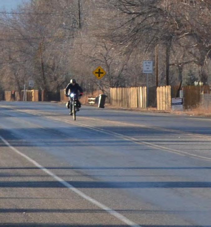
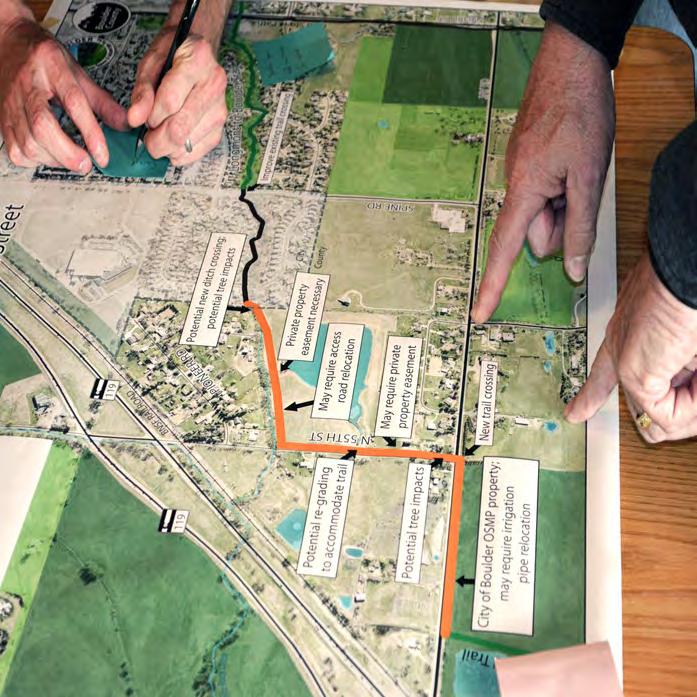
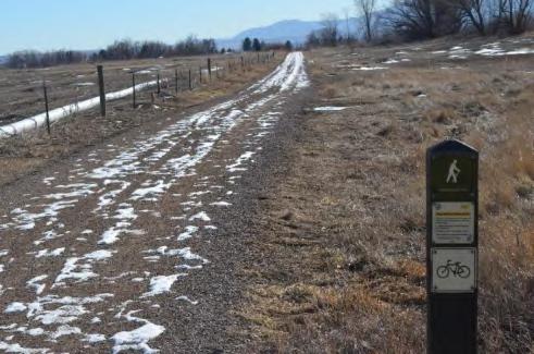
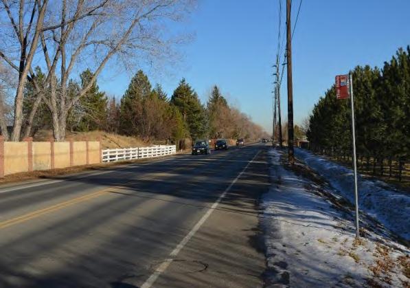
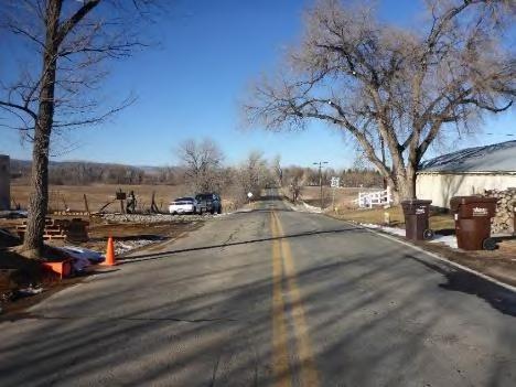
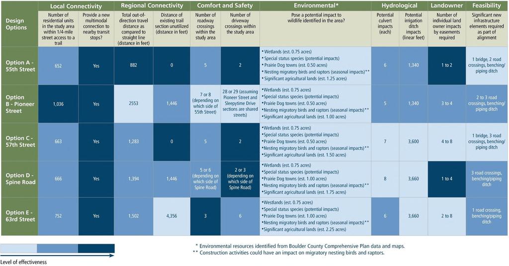
2 Project Summary Boulder County, Colorado, in partnership with the City of Boulder, is evaluating options for multi-use trail connections between the Longmont-to-Boulder (LOBO) Regional Trail at Spine Road and the Cottonwood Trail at Jay Road. This section of trail is a missing link in the LOBO Regional Trail, and it is identified as a conceptual alignment in the Boulder Valley Comprehensive Plan and the Boulder County Transportation Master Plan. Current trail users use the paved shoulder of Jay Road and a narrow sidewalk on Spine Road to make this connection. When complete, this trail would fully connect the City of Longmont, Gunbarrel and the City of Boulder, while also connecting the more local trail systems in these communities. This planning project refines the alignments identified in the 2003 Regional Trails planning process and develops some design and cost estimates for future trail design and construction along with grant application processes such as the Denver Regional Council of Governments (DRCOG) Transportation Improvement Program (TIP) amendment cycles. This project envisions an off-street multi-use trail that supports comfortable regional active travel while also enhancing access for localized recreational activities and nearby transit facilities. The design of the trail will maintain context sensitivity to the surrounding landscape and encourage users to respect the limits of the public access and to protect the privacy of adjacent landowners. The study initially identified five potential alternatives to make this trail connection: Option A 55th Street Option B Pioneer Street Option C 57th Street Option D Spine Road Option E 63rd Street Detailed descriptions of each alternative can be found in Appendix D. All five potential alternatives were presented to the public at an open house held April 10, 2018, at the Celestial Seasonings facility in Boulder. Option A, 55th Street, received the most support from those who attended the public meeting, while Option D, Spine Road, was selected as a close second. A summary of the community feedback received at the first public open house can be found in Appendix C. To screen the five alternatives, the project team created evaluation criteria that reflect the vision and goals of the project. The criteria allowed each option to be compared to the others and helped the project team to rank and determine a best-fit alternative. Results show Option A is the most favorable alternative, with Option D as a close second, which mirrors the feedback received at the first public open house. Results of the alternative screening can be found in Appendix D. The second public open house was held June 13, 2018, again at Celestial Seasonings in Boulder. At this meeting, Option A was presented to the public as the preferred alternative. Option D was presented to the public as the second preferred alternative to be considered should consultation due to private landowner impacts associated with Option A pose a delay to the delivery of the LOBO connection. Strong support was again displayed for Option A, the most direct route. A summary of the community feedback received at the second public open house can be found in Appendix E. Based on the feedback from the public and the outcomes of the alternative evaluation, Boulder County and Atkins North America, Inc. (Atkins) agree that Option A and Option D will be taken forward to preliminary engineering with development of 15% designs. Figure 1 outlines the general alignment of Option A and Option D. Schematic designs of the preferred alternatives will provide more refined alignments, which will be used to develop cost estimates and phasing of improvements toward Atkins Longmont to Boulder Regional Trail, Jay Road Connection December
3 implementation. Preliminary engineering, cost estimation, and phasing will take place during the winter of 2018/2019. In addition to the two public open houses, Boulder County has conducted extensive outreach with property owners who may be impacted by the proposed trail connections. Consultation is ongoing with these property owners and individual impacts will be more accurately determined after land surveys and preliminary engineering is complete. This report compiles technical memos, generated at various stages of the study, in a series of appendices to provide the reader with an overview of the study to date. Appendix A Key Issues, Vision, and Goals: outlines the critical project issues and needs and identifies the six goals of the project. Appendix B Data Collection and Project Scoping: provides an overview of the project scoping and data collection efforts, including desktop research and site visits undertaken as part of the project. Appendix C Public Open House #1: summarizes the community feedback received at the first public open house at which initial conceptual trail alignments were presented. Appendix D Alternative Evaluation Analysis: describes the initial design options and summarizes the results of the alternative evaluation and screening process. Appendix E Public Open House #2: provides a summary of the community feedback received at the second public open house at which the preferred alternative and second preferred alternative were presented. Appendix F Preliminary Engineering of the Preferred Alignment: outlines the key design decisions and cost estimate for the schematic design of the preferred alternatives, Option A and Option D. Atkins Longmont to Boulder Regional Trail, Jay Road Connection December

4 Figure 1: Preferred Route Options Atkins Longmont to Boulder Regional Trail, Jay Road Connection December
5 Appendix A. Key Issues, Vision, and Goals Atkins Longmont to Boulder Regional Trail, Jay Road Connection December 2018


6
7
8
9 Appendix B. Data Collection and Project Scoping Atkins Longmont to Boulder Regional Trail, Jay Road Connection December 2018
10 Data Collection and Project Scoping Report Introduction Study Area

11 Figure 1 - Study Area
12 Project Planning and Engineering Resources
13
14 Data Sources and Collection Methods

15 Project Coordination and Community Involvement Site Visit Existing Conditions

16
17 Table 1 - Roadway Network Summary

18 Figure 2 - Existing Conditions

19 Figure 3 - Existing Land Use and Land Owner Parcels
20 Environmental Summary Table 2 Environmental Summary

21 Figure 4 - Environmental Summary Map
22 Appendix C. Public Open House #1 Atkins Longmont to Boulder Regional Trail, Jay Road Connection December 2018
23 Public Open House #1 Introduction Table 1 Community Input Themes Separation from traffic on Jay Road is important for safety and comfort of trail users. Concern with speeds and numbers of vehicles on Jay Road. Desire for protected crossing treatment on Jay Road that enhances safety for pedestrians, bicyclists (and livestock) underpass and signalized intersection suggested. Desire to minimize the number and extent of private property impacted. Prefer a route that provides the shortest and most direct link between the Cottonwood Trail and LOBO. Concern that less direct routes will not be utilized. Prefer to utilize low-volume streets that enhance comfort and safety for users. Want a route that provides connection to most residential units to ensure trail is more accessible to users. Comfort and safety is one of the project goals. Providing appropriate separation between trail users and vehicles will be prioritized as part of the design Comfort and safety is one of the project goals. Comfortable crossing will be prioritized as part of the design Private property impacts will be quantified in the evaluation process Out of direction travel will be evaluated for each alternative Comfort and safety is one of the project goals. Feasibility of utilizing low volume streets will be assessed in the evaluation process Evaluation process will quantify the additional households within ¼ mile of the trail alternatives
24 Prefer a route that utilizes existing portions of LOBO Trail. Will be quantified in evaluation process 8 Concern for privacy of private landowners. Suggestion to install fences or other treatments that ensure the privacy of landowners. Concern with trail activity impacts, in particular noise and volume impacts, on streets and areas that are currently quiet. All options should include safe crossing points on Jay Road, including Option E - 63 rd Street which only uses the south side of Jay Road. Desire treatments to protect bicyclists along Jay Road from Cottonwood Trail to 63 rd Street, including the Jay/63 rd intersection, and further east to 75 th Street, in addition to any trail that may be constructed. Jay Road noted as heavily trafficked bicycle route and should be accommodated. Concerns with speed on Jay Road, 57 th Street and 63 rd Street. Desire for traffic calming and creating an environment that reflects the multimodal needs of this area. Concern with westbound vehicles along Jay Road using the bike lane to get around left turning vehicles. Concern with impact to wildlife and trees. Desire for improved wayfinding for LOBO trail. Desire for wide trail that comfortably accommodates pedestrian and bicycles in each direction, at crossings, and at any bends in alignment. High level assessment of feasibility separation using treatments Privacy is one of the project goals. Impact to private landowners will be assessed in the evaluation process and minimizing impacts will be prioritized in the design Evaluation process will quantify the number of road/driveway crossings per trail. Comfortable crossing design will be prioritized Will consider further during trail design for any alternative Traffic calming is likely to considered with any crossing treatment. Will consider further during trail design Will consider further during trail design for any alternative Study will follow environmental process for protection and to minimize impacts to wildlife Will consider further during trail design for any alternative Comfort and safety is one of the project goals. Comfortable trail design will be prioritized Interest in surface that can be used all year round, with narrow tires, and provides good skid resistance. Boulder County s Multi-Modal Standards states that: compacted crusher fines shall be the preferred material, although surface materials shall be considered on a case-by-case basis. Will be considered during trail design 11
25 Appendix D. Alternative Evaluation Analysis Atkins Longmont to Boulder Regional Trail, Jay Road Connection December 2018

26 Alternative Evaluation Analysis Introduction Options
27
28
29
30

31
32 Alternative Evaluation Criteria Public Open House Alternative Evaluation
33
34
35 Appendix E. Public Open House #2 Atkins Longmont to Boulder Regional Trail, Jay Road Connection December 2018

36 Public Open House #2 Introduction
37 Table 1 Community Input Themes Strong support for Option A. Desire for this connection to be constructed as soon as possible. Safety concerns for trail users crossing and running alongside Jay Road. Desire to separate trail from Jay Road. Higher speed/commuter cyclists do not like the existing section of trail east of 63 rd Street. It is noted that the alignment of this section requires slow bicycle speeds, the curvature of trail increases conflict points, and the bridges create pinch points. It is also noted that there are high pedestrian volumes along this section. More confident cyclists will continue to use 63 rd Street and Spine Road to avoid this section. Desire for connection between 63 rd Street and Cottonwood Trail that facilitates higher speed cyclists. This option also scored highest in the alternative evaluation process, giving the project team confidence that the best option has been selected for more detailed design. Comfort and safety is one of the project goals. Providing appropriate separation between trail users and vehicles will be prioritized as part of the design. Boulder County are proposing several near-term changes to Jay Road to improve corridor safety which include: Between 30th and 63rd streets striping a one-foot buffer to separate the travel lane from the shoulder. Between 30th and 75th streets applying green paint to the shoulder to highlight the shoulder and bike lane at intersections. These improvements to Jay Road will make conditions more comfortable for cyclists who choose not to use the proposed trail connection Strong desire for underpass to cross Jay Road to reduce conflicts with high speed, high volume traffic on Jay Road. Will be considered further during trail design. 11 Concern that private property easement required along 55 th Street could stall progress of the project. Ensure trail is wide enough to comfortably accommodate high usage from pedestrians and bicyclists Desire for improvements to 63 rd Street multi-use path and connect to City of Boulder s Confluence project. Boulder County have met with this landowner on several occasions regarding the trail alignment and are hopeful an agreement can be made. If this alternative poses significant delay to the project timeline Option D, the second preferred alternative, may be considered instead. Comfort and safety is one of the project goals. Comfortable trail design will be prioritized. The scope of this project is to connect the Cottonwood Trail to the Longmont-to-Boulder Trail. The City of Boulder have plans to connect the existing 63 rd Street multi-use path as part of the Andrus Road to Airport Road Multi-Use Path Project Off-leash dogs are noted as an issue for trail users between 63 rd Street and Spine Road. 2 Concern with impacts to ditches, agricultural lands and other environmental resources It is a goal of the project to design a trail that is context sensitive, mitigating impacts to ecological and natural systems throughout the designated trail corridor. 2
38 Ensure 55 th Street is bike friendly It is intended that the trail would be off-street, running parallel but separate from 55 th Street. 1 Concern with widening 55 th Street It is intended that the trail would be off-street, running parallel but separate from 55 th Street. 1 Desire for existing trail crossing at Spine Road to be improved It is intended to improve this existing crossing as part of the trail construction. 1 Visibility concerns for bicycles and vehicles with hills on 55 th Street It is intended that the trail would be off-street, running parallel but separate from 55 th Street. 1 Preference for the proposed trail to be paved Trails in this area will be constructed to Boulder County s Multi-Modal Standards which state: compacted crusher fines shall be the preferred material, although surface materials shall be considered on a case-by-case basis. 1 Explore opportunity to educate trail users of good trail behavior and etiquette. Boulder County will consider educational opportunities. 1

39 Appendix F. Preliminary Engineering of the Preferred Alignment Atkins Longmont to Boulder Regional Trail, Jay Road Connection December 2018
40 Conceptual designs of two alternatives are under way and will be included here when complete. Atkins Longmont to Boulder Regional Trail, Jay Road Connection December 2018
41 Heather Andrews Atkins North America 7604 Technology Way Suite 400 Denver, CO Tel: Fax: Atkins Ltd except where stated otherwise
AGENDA ITEM 5 D WAKULLA ENVIRONMENTAL INSTITUTE (WEI) TRAIL FEASIBILITY STUDY
 TRAIL FEASIBILITY STUDY") March 19, 2018 AGENDA ITEM 5 D WAKULLA ENVIRONMENTAL INSTITUTE (WEI) TRAIL FEASIBILITY STUDY TYPE OF ITEM: Action STATEMENT OF ISSUE The Wakulla Environmental Institute (WEI) Trail is one of several trails
March 19, 2018 AGENDA ITEM 5 D WAKULLA ENVIRONMENTAL INSTITUTE (WEI) TRAIL FEASIBILITY STUDY TYPE OF ITEM: Action STATEMENT OF ISSUE The Wakulla Environmental Institute (WEI) Trail is one of several trails
Committee. Presentation Outline
 CW-33-15 11/9/2015 Community and Corporate Services Committee November 10, 2015 1 Presentation Outline Background Vision and Objectives Study Process and Timeline Public and Stakeholder Engagement Organization
Auburn Trail / Ontario Pathways Trail Connector Feasibility Study Public Information Meeting Wednesday, August 22, 2012
 Auburn Trail / Ontario Pathways Trail Connector Feasibility Study Public Information Meeting Wednesday, August 22, 2012 Purpose of Feasibility Study Purpose Evaluate the feasibility of constructing a multiuse
Macleod Trail Corridor Study. Welcome. Macleod Trail Corridor Study Open House. Presentation of Proposed Design Concepts
 Macleod Trail Corridor Study Welcome Macleod Trail Corridor Study Open House Presentation of Proposed Design Concepts Study Purpose Develop a corridor plan for Macleod Trail that aligns with The City s:
The Chu property is a 6.57 acre parcel located in the Town of Superior on the west side of McCaslin Boulevard. In 2014, the Town of Superior acquired
 1 The Chu property is a 6.57 acre parcel located in the Town of Superior on the west side of McCaslin Boulevard. In 2014, the Town of Superior acquired the Chu property for open space with a contribution
PURPOSE AND NEED (CONCURRENCE POINT 1) NEW CANADA ROAD PROJECT FROM STATE ROUTE 1 (U.S. HIGHWAY 70) TO U.S. INTERSTATE 40
 NEW CANADA ROAD PROJECT FROM STATE ROUTE 1 (U.S. HIGHWAY 70) TO U.S. INTERSTATE 40") PURPOSE AND NEED (CONCURRENCE POINT 1) NEW CANADA ROAD PROJECT FROM STATE ROUTE 1 (U.S. HIGHWAY 70) TO U.S. INTERSTATE 40 Project Description The primary purpose of this project is to improve the major
PURPOSE AND NEED (CONCURRENCE POINT 1) NEW CANADA ROAD PROJECT FROM STATE ROUTE 1 (U.S. HIGHWAY 70) TO U.S. INTERSTATE 40 Project Description The primary purpose of this project is to improve the major
FEASIBILITY CRITERIA
 This chapter describes the methodology and criteria used to evaluate the feasibility of developing trails throughout the study areas. Land availability, habitat sensitivity, roadway crossings and on-street
ALBANY-HUDSON ELECTRIC TRAIL FEASIBILITY STUDY. Final Report OCTOBER 2011
 ALBANY-HUDSON ELECTRIC TRAIL FEASIBILITY STUDY Final Report OCTOBER 2011 ALBANY-HUDSON ELECTRIC TRAIL FEASIBILITY STUDY Prepared for: Town of East Greenbush 225 Columbia Turnpike Rensselaer, New York 12144
MUNICIPALITY OF ANCHORAGE
 MUNICIPALITY OF ANCHORAGE ANCHORAGE PARKS & RECREATION Memorandum PRC 08-56 DATE: 5 August 2008 TO: FROM: SUBJECT: Parks & Recreation Commission Holly Spoth-Torres, Park Planner PRC 08-56 Far North Bicentennial
Becker County Trail Routing Feasibility Study
 2016 Becker County Trail Routing Feasibility Study CONNECTING DETROIT MOUNTAIN AND MOUNTAIN VIEW RECREATIONAL AREA TO THE HEARTLAND TRAIL BECKER COUNTY ULTEIG ENGINEERS Contents Acknowledgements...2 INTRODUCTION...3
Blueways: Rivers, lakes, or streams with public access for recreation that includes fishing, nature observation, and opportunities for boating.
 Parks, Open Space and Trails PRINCE WILLIAM COUNTY 2008 COMPREHENSIVE PLAN TRAILS PLAN CONTENTS The components of the trails plan are: Intent Definitions Goals, Policies, and Action Strategies Trails Map
US 380 FEASIBILITY STUDY
 US 380 FEASIBILITY STUDY Denton County CSJ(s): 0135-10-061, 0135-10-062 Public Meeting(s): January 15 & 22, 2019 WELCOME US 380 Denton County Feasibility Study DALLAS DISTRICT PUBLIC MEETING January 15
Trail # NW Tuesday, June DESIGN. Provide an Review the Provide an. Project Goals: System system. wayfinding
 I. Welcome / Introductions Bethany Creek Trail #2 Segment 3 Neighborhood Meeting #1 Bethany Presbyterian Church 15505 NW Springville Road, Portland, OR 97229 Tuesday, June 26, 2018 @ 6:00PM Meeting Minutes
Blue River Trail Master Plan JSA to Town Hall June 2004
 Blue River Trail Master Plan JSA to Town Hall June 2004 Prepared for: Silverthorne Town Council Silverthorne SPORT Committee Department of Recreation and Culture Silverthorne Public Works Silverthorne
Citrus Heights Creek Corridor Trail Project Trail Advisory Group Field Trip #2 September 11, :00 11:00 am Trellis Hall, Citrus Heights
 September 11, 2013 9:00 11:00 am Trellis Hall, Citrus Heights Project Overview The City of Citrus Heights is studying the feasibility of establishing a multi use trail system within the City s 26 miles
FINCH HYDRO CORRIDOR TRAIL PROJECT
 FINCH HYDRO CORRIDOR TRAIL PROJECT Pharmacy Avenue to Birchmount Road January 29 th, 2018 L Amoreaux Community Centre (2000 McNicoll Avenue) 1 Purpose of Drop In Event The purpose of today s drop-in event
Memo. Orange City Trail Plan Becky Mendez, AICP Jamie Krzeminski, PE, PTOE Matt Wiesenfeld, PE, AICP. Development of the Existing and Proposed Network
 Memo Date: Friday, December 22, 2017 Project: To: From: Subject: Trail Plan Becky Mendez, AICP Jamie Krzeminski, PE, PTOE Matt Wiesenfeld, PE, AICP Development of the Existing and Proposed Network HDR
3. COLTA / HUGA CONNECTIONS - PRELIMINARY
 9 3. COLTA / HUGA CONNECTIONS - PRELIMINARY 3.1 COLTA The Chain of Lakes Trail Association (COLTA) trail, formerly identified as the Chester Spur Line, was completed and opened for use in June 2011. The
MEETING MINUTES District 1 Trail Planning Meeting 1
 MEETING MINUTES District 1 Trail Planning Meeting 1 June 1, 2017 2:00 PM 3:30 PM City of Two Harbors 2:00 Introductions Attendees: Lisa Austin, MnDOT Bryan Anderson, MnDOT Jasna Hadzic-Stanek, MnDOT Justin
City of Durango 5.8 FUNDING TRAILS DEVELOPMENT
 5.8 FUNDING TRAILS DEVELOPMENT The City has been successful in establishing dedicated local funding sources as well as applying for grants to develop the City s trail system, having received nearly $2.4
Section II. Planning & Public Process Planning for the Baker/Carver Regional Trail began in 2010 as a City of Minnetrista initiative.
 Section II Planning & Public Process Planning for the began in 2010 as a City of initiative. city staff began discussions with the Park District on the possibility of a north/south regional trail connection
Welcome to the Cross County Trail Public Input Session!
 Welcome to the Cross County Trail Public Input Session! Please sign in on the table below! What are we doing here? Camden County has proposed a bicycle and pedestrian trail spanning across the entire county.
Georgetown-Lewes Rail/Trail Study. Rail/Trail Study: Cool Spring to Cape Henlopen State Park New Road Extension (House Resolution No.
 Georgetown-Lewes Rail/Trail Study Rail/Trail Study: Cool Spring to Cape Henlopen State Park New Road Extension (House Resolution No. 47) August 22, 2011 Presentation Outline Background Benefits Statewide
America s Great Outdoors: Feasibility Study for Connecting Urban Refuges to the Rocky Mountain Greenway Trail Network
 Case 1:18-cv-01017-PAB Document 7-17 Filed 05/31/18 USDC Colorado Page 1 of 42 America s Great Outdoors: for Connecting Urban Refuges to the Rocky Mountain Greenway Trail Network Rocky Flats and Two Ponds
Mohawk Hudson Bike Hike Trail Crossroad Connection Study
 Summary Report - April 21, 2003 Mohawk Hudson Bike Hike Trail Crossroad Connection Study Summary Report Introduction The Capital District Transportation Committee (CDTC), in partnership with Albany County,
3.6 PARKLANDS, OPEN SPACE, AND RECREATION AREAS
 3.6 PARKLANDS, OPEN SPACE, AND RECREATION AREAS 3.6.1 Introduction to Analysis 3.6.1.1 Summary of Results Approximately 2.28 acres of parkland, open space, and conservation easements would be acquired
Glasgow Street Traffic Review
 Glasgow Street Traffic Review Recommendation That the Standing Policy Committee on Transportation recommend to City Council: 1. That the Administration proceed with removing the pinch points installed
Public Workshop Preliminary Plans Review. Projects PW 1605, 1701, & 1702
 Queens Mirror Circle Pedestrian Safety Improvements Quail Pond Circle Complete Street/Pedestrian Connectivity Improvements Southcot Drive Bicycle/Pedestrian Improvements Public Workshop Preliminary Plans
Update on Route 1 Efforts
 County of Fairfax, Virginia Update on Route 1 Efforts Transportation Advisory Committee October 20, 2015 Leonard Wolfenstein, FCDOT Jane Rosenbaum, FCDOT Doug Miller, FCDOT Route 1 Corridor 16- mile section
3.6 PARKLANDS, OPEN SPACE, AND RECREATION AREAS
 3.6 PARKLANDS, OPEN SPACE, AND RECREATION AREAS 3.6.1 Introduction to Analysis 3.6.1.1 Summary of Results Approximately 2.79 acres of parkland, open space, and conservation easements would be acquired
Business Item No
 Metropolitan Parks and Open Space Commission Meeting date: February 6, 2018 For the Community Development Committee meeting of February 20, 2018 For the Metropolitan Council meeting of February 28, 2018
SR 934 Project Development And Environment (PD&E) Study
 Study") SR 934 Project Development And Environment (PD&E) Study Project Advisory Group Meeting March 1, 2018 State Road 934/NE/NW 79th Street from west of I-95 (NW 13th CT) to N. Bayshore Drive PD&E STUDY SR 934/NE/NW
SR 934 Project Development And Environment (PD&E) Study Project Advisory Group Meeting March 1, 2018 State Road 934/NE/NW 79th Street from west of I-95 (NW 13th CT) to N. Bayshore Drive PD&E STUDY SR 934/NE/NW
Dungeness Recreation Area County Park Master Plan
 Dungeness Recreation Area County Park Public Outreach Meeting October 10, 2007 Project Overview USFWS Site Dungeness Recreation Area County Park Meeting Objectives: Re-Introduce project; provide status
Northaven Trail Phase 2 Initial Project Overview
 Northaven Trail Phase 2 Initial Project Overview Partnership Project to extend existing Northaven Trail Improve Bike/Ped Connectivity On Dallas Trail Network Plan City and County Funding Oncor Texas Trails
Route 29 Solutions Projects
 Your guide to the Route 29 Solutions Projects For full details & continued engagement please visit www.route29solutions.org The Route 29 Solutions Package is a $230 million investment into the improvement
4.0 Context for the Crossing Project
 4.0 Context for the Crossing Project This section provides background information about key features of the North Douglas Crossing project area, and opportunities and constraints. This information is important
user s guide to Transportation Improvements in Astoria Planning Efforts outside Astoria for more information, contact:
 The Miles Crossing/ Jeffers Garden transportation plan (underway), will identify needed improvements to the Warrenton Astoria Highway and local street improvements to serve expected growth in the Miles
EAST DON TRAIL ENVIRONMENTAL ASSESSMENT. Community Liaison Committee Meeting #3 July 15, :30 to 8:30 pm Flemingdon Park Library
 EAST DON TRAIL ENVIRONMENTAL ASSESSMENT Community Liaison Committee Meeting #3 July 15, 2013 6:30 to 8:30 pm Flemingdon Park Library Agenda 1. Welcome 2. Housekeeping and Updates a) Housekeeping b) CLC
4. Safety Concerns Potential Short and Medium-Term Improvements
 NH Route 104 Access Management Study Page 19 4. Safety Concerns Potential Short and Medium-Term Improvements Potential safety improvement strategies are listed by priority based on field observations by
A CASE FOR COMPLETING THE JORDAN RIVER PARKWAY: A
 A CASE FOR COMPLETING THE JORDAN RIVER PARKWAY: A safe crossing at 9000 South and 850 West Proposed 9000 South Underpass Parkway Timeline Parkway, Trail, and Tourism Facts Blueprint Jordan River 1971 1973
Stage 2 ION: Light Rail Transit (LRT) from Kitchener to Cambridge
 from Kitchener to Cambridge") Stage 2 ION: Light Rail Transit (LRT) from Kitchener to Cambridge Public Consultation Centre (PCC) No. 3 Please Sign-in Cambridge City Hall November 21, 2017 2:00 to 8:00pm Preston Memorial Auditorium
Stage 2 ION: Light Rail Transit (LRT) from Kitchener to Cambridge Public Consultation Centre (PCC) No. 3 Please Sign-in Cambridge City Hall November 21, 2017 2:00 to 8:00pm Preston Memorial Auditorium
Spadina Avenue Built Form Study Preliminary Report
 STAFF REPORT ACTION REQUIRED Spadina Avenue Built Form Study Preliminary Report Date: July 9, 2014 To: From: Wards: Reference Number: Toronto and East York Community Council Director, Community Planning,
A BOAT RAMP TO NOWHERE
 A BOAT RAMP TO NOWHERE A PROPOSAL FOR ACCESS TO HARVIE PASSAGE A Presentation to the City of Calgary December 2017 Presented by: Peter Crowe-Swords Bow River Trout Foundation Background: The Bow River
Airport Planning Area
 PLANNING AREA POLICIES l AIRPORT Airport Planning Area LOCATION AND CONTEXT The Airport Planning Area ( Airport area ) is a key part of Boise s economy and transportation network; it features a multi-purpose
CHAPTER 1: INTRODUCTION
 CHAPTER 1: INTRODUCTION Purpose and Scope The information presented in this report represents the study findings for the 2016 Ronan Airport Master Plan prepared for the City of Ronan and Lake County, the
Public Open House. Chief Peguis Trail Project
 Public Open House Chief Peguis Trail Project CHIEF PEGUIS TRAIL OPEN HOUSE Welcome! Please browse the display boards Project Engineers and City of Winnipeg representatives are available to address your
St. Dennis Drive Conversion of Traffic Lanes to On- Street Parking and Bicycle Lanes
 STAFF REPORT ACTION REQUIRED St. Dennis Drive Conversion of Traffic s to On- Street Parking and Bicycle s Date: April 22, 2014 To: From: Wards: Reference Number: Public Works and Infrastructure Committee
St. John s Park Redevelopment Master Plan Public Engagement Report
 St. John s Park Redevelopment Master Plan Public Engagement Report Prepared by HTFC Planning & Design October 2017 TABLE OF CONTENTS 1.0 Introduction........ 1 2.0 Stakeholder and Public Notification......
Dover Park Master Plan. Community Design Event Tuesday, May 22, 5 7 pm
 Dover Park Master Plan Community Design Event Tuesday, May 22, 5 7 pm Agenda I. Introduction / Overview 20 minutes II. Small Group Design Activity 60 minutes III. Small Group Report Out IV. Conclusion
Construction Staging Adelaide Street West
 REPORT FOR ACTION Construction Staging Adelaide Street West Date: October 6, 2016 To: Toronto and East York Community Council From: Acting Director, Transportation Services, Toronto and East York District
MPRB: Southwest LRT Community Advisory Committee Issues and Outcomes by Location Current to: 12 November 2010
 MPRB: Southwest LRT Community Advisory Committee Issues and Outcomes by Location Current to: 12 November 2010 This is a compilation of issues and outcomes identified by the CAC. It is a work in progress,
#1. Why is the City doing this project?
 Community Workshop #2 January 2016 #1. Why is the City doing this project? Broadway and Lincoln are in constant change Broadway and Lincoln are in constant change Broadway and Lincoln are in constant change
ANCLOTE COASTAL TRAIL ALTERNATIVES ANALYSIS STUDY
 ANCLOTE COASTAL TRAIL ALTERNATIVES ANALYSIS STUDY PASCO COUNTY MPO JULY 2015 PROJECT OVERVIEW... INTRODUCTION EXECUTIVE SUMMARY CONTEXT... TAMPA BAY AREA, PINELLAS, & PASCO COUNTY S MULTI-USE TRAIL PLANS
Calderdale MBC. Wards Affected: Town. Economy and Investment Panel: 20 October Halifax Station Gateway Masterplan
 Calderdale MBC Wards Affected: Town Economy and Investment Panel: 20 October 2016 Halifax Station Gateway Masterplan Report of the Acting Director, Economy and Environment 1. Purpose of the Report 1.1
Auburn Trail/Ontario Pathways Trail Connector Feasibility Study Project Advisory Group Meeting August 25, 2011 Farmington Town Hall Approved Minutes
 Auburn Trail/Ontario Pathways Trail Connector Feasibility Study Project Advisory Group Meeting August 25, 2011 Farmington Town Hall Approved Minutes Committee Members Attending: Ronald L. Brand, Director
ONONDAGA CREEKWALK PHASE II. Public Information Meeting Series 1
 ONONDAGA CREEKWALK PHASE II Public Information Meeting Series 1 Andrew Maxwell Director, Syracuse-Onondaga County Planning Agency Owen Kerney Assistant Director for City Planning Russell Houck, PE City
Auke Bay Area Plan. DRAFT Transportation Chapter
 Auke Bay Area Plan DRAFT Transportation Chapter Existing Conditions This plan comes at a time of change in the transportation infrastructure within Auke Bay. Both marine and upland transportation facilities
Great Wolf Lodge Fact Sheet & Frequently Asked Questions Potential Location in Gilroy, California 8/30/17
 WHAT? Great Wolf Resorts has identified Gilroy, California as a potential location for a new Great Wolf Lodge family resort and has entered into a 60-day period of exclusivity with the City and community
Thornton Water Project. Larimer County Route Study and Project Update September 12, 2017
 Thornton Water Project Larimer County Route Study and Project Update September 12, 2017 Purpose of Meeting Provide information on the Thornton Water Project Present the results of the pipeline routing
Appendix 6 Fulbourn Greenway Review
 Appendix 6 Fulbourn Greenway Review Nigel Brigham & Associates A report for 1 Introduction This report is based on fieldwork carried out in 2016 to review the Greenway network around Cambridge as shown
2016 Regional Transportation Alternatives Program (TAP) Grant Application
 Grant Application") 2016 Regional Transportation Alternatives Program (TAP) Grant Application PROJECT TITLE: Yelm-Tenino Trail Extension Feasibility Study TRPC use only GENERAL PROJECT INFORMATION Agency or Organization City
2016 Regional Transportation Alternatives Program (TAP) Grant Application PROJECT TITLE: Yelm-Tenino Trail Extension Feasibility Study TRPC use only GENERAL PROJECT INFORMATION Agency or Organization City
The Vision for the San Juan Islands Scenic Byway
 The Vision for the San Juan Islands Scenic Byway 2 Judd Cove, Orcas Island, Courtesy of Kurt Thorson (kurtthorson.com) and San Juan County Land Bank Vision for the San Juan Islands Scenic Byway The San
November 11, 2009 BY . Planning and Growth Management Department 110 Laurier Avenue West, 4 th Floor Ottawa, Ontario K1P 1J1. Dear Mr.
 November 11, 2009 Planning and Growth Management Department 110 Laurier Avenue West, 4 th Floor Ottawa, Ontario K1P 1J1 BY E-MAIL Attention: Mr. Don Herweyer Dear Mr. Herweyer: Reference: Abbott-Fernbank
Proposed Bicycle Lanes on Yonge Street from Queens Quay to Front Street
 STAFF REPORT ACTION REQUIRED Proposed Bicycle Lanes on Yonge Street from Queens Quay to Front Street Date: March 12, 2007 To: From: Toronto and East York Community Council Director, Transportation Infrastructure
Multimodal Planning Studies
 Multimodal Planning Studies Commuter Park and Ride Study Steering Committee Meeting June 6, 2013 Agenda 1. Update on Project Schedule 2. Update on Online Interactive Mapping 3. Key Themes from the Open
Lafourche Parish Government REQUEST FOR QUALIFICATIONS. Landscape Architectural Services
 Lafourche Parish Government REQUEST FOR QUALIFICATIONS Landscape Architectural Services Bayou Lafourche Parish Multi-Use Path Feasibility Study Phase 1 And Bayou Lafourche Parish Multi-Use Path Feasibility
Parkland County Municipal Development Plan Amendment Acheson Industrial Area Structure Plan
 Parkland County Municipal Development Plan Amendment Acheson Industrial Area Structure Plan New Plan Acheson Industrial Area Structure Plan Amendment Parkland County Municipal Development Plan Board Reference
Railroad Safety Trail
 2.1 INTRODUCTION AND PROJECT SETTING 2.1 Introduction & Project Setting Introduction This study is the result of a directed effort on the part of the City of San Luis Obispo to carry out previously established
Frequently Asked Questions on the Route 29 Solutions Improvements Projects
 Frequently Asked Questions on the Route 29 Solutions Improvements Projects Background What are the Route 29 Solutions improvement projects? These projects include the Route 29/250 Interchange ( Best Buy
Those with Interest in the City of Cambridge Trail System
 Community Services Department City Hall 50 Dickson Street, P.O. Box 669 Cambridge ON N1R 5W8 Tel: 519-740-4681 July 20, 2010 To: Re: Those with Interest in the City of Cambridge Trail System City of Cambridge
Engagement Summary Report. Trans-Canada Highway 1 RW Bruhn Bridge and Approaches Project Community Engagement February 1 18, 2018.
 Trans-Canada Highway 1 RW Bruhn Bridge and Approaches Project Community Engagement February 1 18, 2018 Engagement Summary Report April 2018 Prepared by Kirk & Co. Consulting Ltd. Trans-Canada Highway 1
Figure 1: Little Dry Creek Trail Crossing
 Figure 1: Little Dry Creek Trail Crossing Figure 2: Little Dry Creek Trail Crossing Northwest Rail Environmental Evaluation Temporary Trail Detour Concurrence Form Adams County, Little Dry Creek Trail
Chapter 6: POLICY AND PROCEDURE RECOMMENDATIONS
 Chapter 6 POLICY AND PROCEDURE RECOMMENDATIONS FOR SRRA Below are seven policy elements that should be considered for adoption by the Southwest Regional Recreation Authority of Virginia: 1. Develop strategies
Portneuf Greenway Trail System
 Portneuf Greenway Trail System The purpose of this Master Plan is to outline the vision for the development of the Portneuf Greenway Trail System Master Plan Approved BTPO January 5, 2009 Table of Contents
APPENDIX OFFICIAL MAP ORDINANCE OF HAMILTONBAN TOWNSHIP OFFICIAL MAP NARRATIVE
 APPENDIX A OFFICIAL MAP ORDINANCE OF HAMILTONBAN TOWNSHIP OFFICIAL MAP NARRATIVE INTRODUCTION: The Official Map of Hamiltonban Township has been prepared to identify those lands and features that Hamiltonban
2. Goals and Policies. The following are the adopted Parks and Trails Goals for Stillwater Township:
 D. PARKS AND TRAILS 1. Introduction Stillwater Township s population is relatively low, with most residents living on rural residences on large lots. The need for active park space has been minimal in
Union Station Queens Quay Transit Link Study
 Welcome Union Station in 1899. Image: City of Toronto Archives Union Station today. Image: Camil Rosiak Activity along Queens Quay. Image: Waterfront Toronto For more information or to comment, visit toronto.ca/waterfronttransit
Minutes Brice Prairie Safety Committee Wednesday, May 2, 2018 Brice Prairie First Responders Building
 Minutes Brice Prairie Safety Committee Wednesday, May 2, 2018 Brice Prairie First Responders Building Members Present: Brian Tippetts, Vicki Burke, Jim Nissen, Jerri Monti, Dave DeBoe, Jolene Huiss, Fritz
Segment 2: La Crescent to Miller s Corner
 goal of the USFWS refuges is to conserve, protect and enhance fish, wildlife and plants and their habitats for the continuing benefit of the American people. Refuge lands are used largely for fishing,
Chapter 2: Entire US287 Corridor
 Chapter 2: Entire US287 Corridor The US287 Study Area spans four incorporated jurisdictions and two counties. Due to the length and density of infrastructure along the US287 Study Area, corridor-wide maps
NORTHEAST CARLTON COUNTY BICYCLE ROUTE PLAN
 NORTHEAST CARLTON COUNTY BICYCLE ROUTE PLAN 5/31/2014 and St. Louis River Trail Plan Update Produced by the Arrowhead Regional Development Commission (ARDC) in Partnership with the State Health Improvement
OPEN HOUSE PRESENTATION
 Thank You For Attending Today Capital District Transportation Committee Behan Planning and Design The Chazen Companies Engineering Sidekick Creative C onsultecon, Inc. R obert B engraff Drone Pilot What
A link to heritage by connecting the community to its history.
 In March 2015 the Board of Sentiers Chelsea Trails asked Chelsea Council to explore the feasibility of converting the winter rail corridor trail into a 4 season, non-motorized, multi-purpose trail. To
Little River Trail Feasibility Study
 Final April, 2014 Prepared for the State Coastal Conservancy By the Natural Resources Services Division of Redwood Community Action Agency Table of Contents Executive Summary... 1 1. Project Purpose and
ROAD AND TRAIL PROJECT APPROVAL
 ROAD AND TRAIL PROJECT APPROVAL www.marincountyparks.org Marin County Parks, 3501 Civic Center Dr, Suite 260, San Rafael, CA 94903 DATE: July 12, 2017 PRESERVE: Gary Giacomini Open Space Preserve PROJECT:
3.0 LEARNING FROM CHATHAM-KENT S CITIZENS
 3.0 LEARNING FROM CHATHAM-KENT S CITIZENS An important aspect in developing the Chatham-Kent Trails Master Plan was to obtain input from stakeholders and the general public. Throughout the course of the
EXECUTIVE SUMMARY FALL Introduction. Findings
 EXECUTIVE SUMMARY FALL 2004 Introduction Trails are one of the most popular and highly desirable recreational resources in communities of all sizes throughout the country. In addition to providing a safe
Project Deliverable 4.1.3d Individual City Report - City of La Verne
 Pomona Valley ITS Project Project Deliverable 4.1.3d Individual City Report - City of La Verne Prepared by: April 19, 2002 099017000.1 Copyright 2002, Kimley-Horn and Associates, Inc TABLE OF CONTENTS
Citrus Heights Creek Corridor Trail Project. Trail Advisory Group Meeting #3 July 8, 2013
 Citrus Heights Creek Corridor Trail Project Trail Advisory Group Meeting #3 July 8, 2013 Agenda Introductions Recap: Community Workshop, Survey Findings, and TAG Field Trip Community Concern Discussion:
DATE: 23 March, 2011 TO: Communities FROM: BlazeSports America. RE: Accessible Trails Checklist 1
 M E M O R A N D U M DATE: 23 March, 2011 TO: Communities FROM: BlazeSports America RE: Accessible Trails Checklist 1 The purpose of the Accessible Trails Checklist (below) is to help the community review
Lake Erie Commerce Center Traffic Analysis
 LOCATION: East of NYS Route 5 at Bayview Road Town of Hamburg Erie County, New York PREPARED BY: Wendel Companies 140 John James Audubon Parkway Suite 200 Amherst, New York 14228 January 2012 i ii Table
McLean Citizens Association Transportation Committee Project Briefing
 McLean Citizens Association Transportation Committee Project Briefing November 10, 2015 Project Map 2 Project Context Only Interstate in the Country limited to HOV only traffic during rush hours Stoplight
RIVER ACCESS STRATEGY
 RIVER ACCESS STRATEGY The River Access Strategy is a 10-year plan the City of Edmonton is developing to inform future programming, operations and infrastructure improvements that support access to the
Pattullo Bridge Replacement Project
 JULY 2018 PROJECT OVERVIEW Pattullo Bridge Replacement Project engage.gov.bc.ca/pattullobridge Artist s rendering of the proposed new Pattullo Bridge Pattullo Bridge Replacement Project 1 Priority Need
LYNDHURST NEW URBAN DEVELOPMENT AREA STRUCTURE PLAN. Lyndhurst New Urban Development Area Structure Plan OUTCOMES AND PERFORMANCE STANDARDS
 APPENDIX 15.1-3 LYNDHURST NEW URBAN DEVELOPMENT AREA STRUCTURE PLAN Purpose of the Structure Plan Lyndhurst New Urban Development Area Structure Plan OUTCOMES AND PERFORMANCE STANDARDS LSP-P1 The District
PEMBERTON VALLEY RECREATIONAL TRAILS MASTER PLAN UPDATE Community Open House. April 2018
 PEMBERTON VALLEY RECREATIONAL TRAILS MASTER PLAN UPDATE Community Open House April 2018 Introductions Introductions Matt Bakker, BHA Project Coordinator Other Team Members: Liz Scroggins, Grey Owl Consulting
I. INTRODUCTION EAST COAST GREENWAY STUDY PURPOSE
 I. INTRODUCTION STUDY PURPOSE The purpose of this study is to determine the engineering feasibility of developing the Eastern Trail. It was initiated at the request of the and funded by the Maine Department
Town of Frisco. Trails Master Plan. Legend. Planning Area 1. i l. 9 Campground. Lake Hill Development. Giberson Property. Frisco Transit Center
 SO-UV I-70 UPPER SALT LICK TOO-PWECH SUNRISE 1 Town of Frisco Planning Area 1 NAH-OON-KARA I-70 Lake Hill Development Legend Existing Trails Existing USFS System Trails 2 A Existing Non-System Trails Bike
Proposal to Redevelop Lower Kananaskis River-Barrier Lake. Bow Valley Provincial Park
 Frequently Asked Questions Proposal to Redevelop Lower Kananaskis River-Barrier Lake Bow Valley Provincial Park Frequently Asked Questions What has been decided? What are the details of the plan? What
Draft Concept Alternatives Analysis for the Inaugural Airport Program September 2005
 Draft Concept Alternatives Analysis for the Inaugural Airport Program September 2005 Section 3 - Refinement of the Ultimate Airfield Concept Using the Base Concept identified in Section 2, IDOT re-examined