Little River Trail Feasibility Study
|
|
|
- Marshall Carr
- 5 years ago
- Views:
Transcription


1 Final April, 2014 Prepared for the State Coastal Conservancy By the Natural Resources Services Division of Redwood Community Action Agency
2 Table of Contents Executive Summary Project Purpose and Goals... 2 Project Background and Purpose... 2 Goals of the Background and History Project Approach Planning Context Review Agency and Public Outreach Trail Alignment Analysis Bridge Crossing Analysis Appraisal Process Appraisal Results Feasibility Analysis of Alignment Alternatives Major Considerations for the Little River Trail Alignments Evaluation of Alignments Alignment North 1 (N1): Alignment North 2 (N2): Alignment North 3 (N3): Alignment South 1 (S1): Alignment South 2 (S2): Little River State Beach Paved Trail Option Bridge Design Recommendations Bridge Option 1 On the Existing Highway 101 Bridge Bridge Option 2 Separated Bridge within Caltrans Right-of-Way Bridge Option 3 Separated Bridge outside Caltrans Right-of-Way Preferred Trail Alignment Preferred Alignment Description Preferred Alignment, North Trail Section: N Preferred Alignment, Bridge Trail Section: B Preferred Alignment, South Trail Section: S Anticipated Environmental and Regulatory Requirements Coastal Act Considerations Mitigation Considerations Zoning Considerations Cultural and Archaeological Resource Study Caltrans Encroachment Permit and New Access Trail Support Facilities Trailhead Locations Additional Trail Support Facility Considerations Interpretative Plan... 61
3 Potential Interpretive Themes Trail Management Strategy Example Cooperative Trail Management Agreements Potential Trail Management Partners Community Involvement in Trail Maintenance Funding Trail Operations and Maintenance Final Recommendations and Next Steps Engineered Designs, CEQA and Environmental Permitting Implementation Fund Seeking Acquisition of the Moonstone Parcel Cultivating Regional Support Closing Appreciation References and Resources Appendices Appendix A California Historical Resources Information System (CHRIS) report Appendix B Little River Trail Task Force Workshop Summary Appendix C Little River Trail Public Comment Summary Appendix D Bridge Feasibility Study Appendix E Green Diamond Resources Company Moonstone Parcel Appraisal Appendix F Trail Alignment Evaluation Matrix Appendix G Caltrans, Coastal Commission Staff s and Blue Lake Rancheria s Comments on the draft LRTFS
4 Executive Summary The (LRTFS), funded by the State Coastal Conservancy, analyzed potential non-motorized trail alignments from the southern end of Scenic Drive across the Little River to Clam Beach Drive. Creating a trail connection along this stretch of Humboldt County coastline would close a key gap in the California Coastal Trail (CCT) currently separating the communities of Westhaven and Trinidad from the Hammond Coastal Trail and Humboldt Bay communities. This trail connection to improve mobility options and recreational opportunities has been a priority for local residents, trail advocates and local and state agencies for almost three decades. The Little River project area is rich in flora, fauna, culture and history. The LRTFS examined trail alignment opportunities and constraints on the ground, researched environmental considerations and cultural histories, and held thorough discussions with cooperating agencies, local Tribal Historic Preservation Officers and the interested public. A preferred alignment and bridge crossing was recommended that offers scenic vistas and a direct trail connection separated from Highway 101 for all non-motorized users while limiting the disturbance of culturally significant and environmentally sensitive areas. A 30% design plan was developed for widening the existing Little River Bridge to include a separated trail crossing. The Little River area has additional opportunities for habitat enhancement and public access surrounding the Little River estuary. The LRT alignment traverses publicly owned properties. However, the LRT is adjacent to a 14-acre private parcel, owned by Green Diamond Resource Company, located just south of Scenic Drive, which would impact the development of the LRT. Green Diamond Resource Company is interested in selling the property to a public or non-profit entity. With the support and participation of Green Diamond Resource Company and as part of this study, the parcel was appraised at market value and its development potential was analyzed. The appraisal estimated the market value of the parcel to be $120,000. The appraisal determined that the highest and best use of the property would be for recreational use, concluding that the development of a single-family residence would be impractical but not impossible. The LRTFS also examines potential cooperative trail management opportunities, regulatory requirements, funding opportunities and other next steps in order to realize the vision of a completed Little River Trail. The study also outlines potential trail support facilities, including parking areas, signage and trail interpretative themes to enhance the experience along the future trail corridor. Finally the LRTFS examines how best to build local support and momentum to advance the completion of this significant segment of the California Coastal Trail and Humboldt County s regional trail network. 1 P age
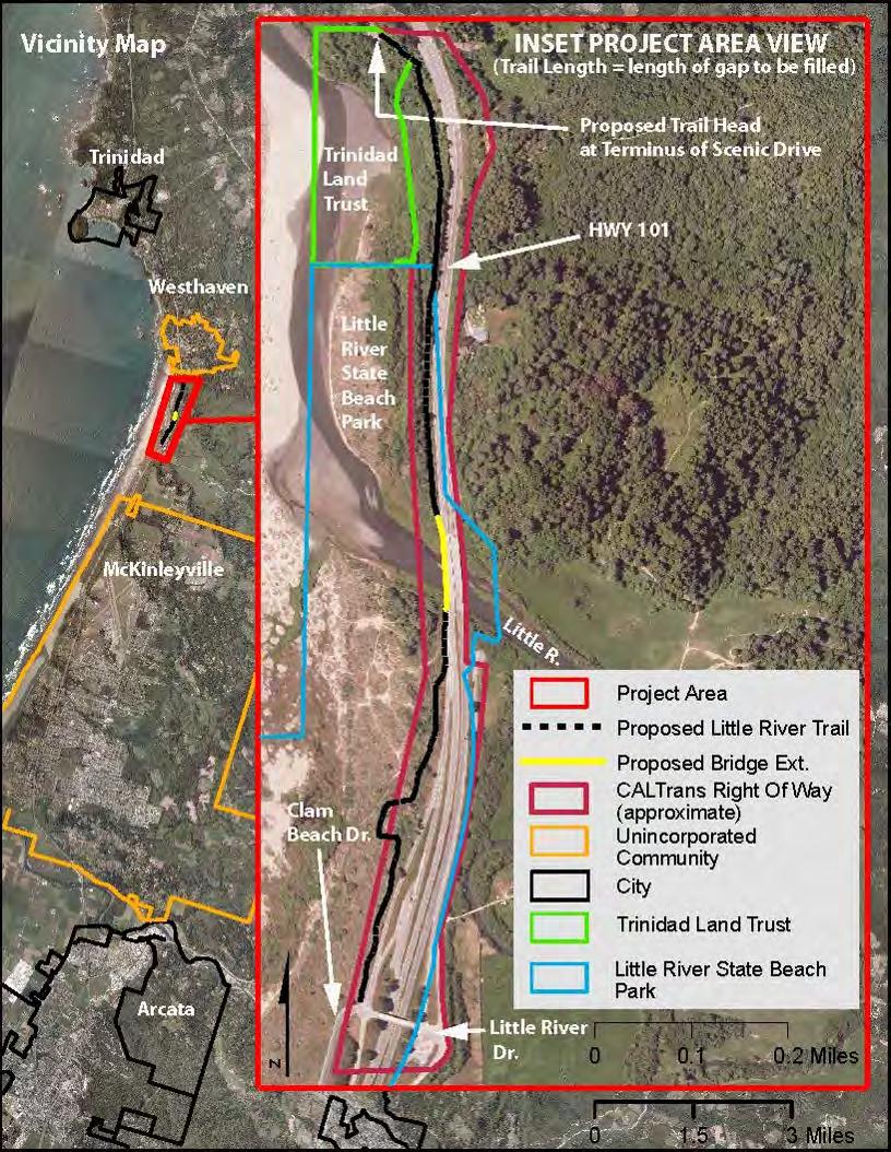
5 1. Project Purpose and Goals The aims to recommend a preferred alignment for a nonmotorized trail connection across the Little River to create a contiguous segment of the California Coastal Trail (CCT) from Arcata to Trinidad. Completing this section of the CCT would enhance a unique section of the Humboldt County coastline, improve transportation and recreation opportunities for local communities and enhance existing public access areas by creating connections that encourage a wider variety of users. Project Background and Purpose Humboldt County has some of the most scenic and rugged coastline in the state, from the towering trees and cliffs overlooking the coast in Redwood National Park to the serene lagoon bars and beaches near numerous river mouths. The Humboldt County coastline presents numerous opportunities for outdoor recreation, environmental conservation and linking communities. However, there are many challenges in connecting communities and public lands along the coast including rugged topography, extensive private property, trail management challenges and limited north-south public routes. The Little River area lies north of Humboldt Bay and south of Trinidad, between the heavily frequented public beaches of Clam Beach and Little River State Beach to the south and Moonstone Beach to the north. Highway 101 serves as the only public road over the Little River and along this stretch of Humboldt County coastline. A non-motorized trail connection over the Little River to connect Humboldt Bay communities to the Hammond Trail has been of great interest to local residents and trail advocates for decades. A trail crossing the Little River would also close a key gap in the California Coastal Trail. The California Coastal Trail (CCT) aims to be a continuous stretch of publicly accessible trail along the state s coastline from Mexico to Oregon. In 2003 the State Coastal Conservancy, directed by California State Legislature SB 908, produced What Still Needs to be Done: Completing the California Coastal Trail. This document noted sections of the proposed Coastal Trail that Needs Substantial Improvement. One of these was the Little River Bridge crossing, and the connection between Scenic Drive and Clam Beach Drive. Currently, bicyclists and pedestrians have limited options traveling south from Scenic Drive in Westhaven and must use the Highway 101 bridge to cross Little River, which is an unappealing and challenging endeavor for most. The on-ramp to Highway 101 from the south end of Scenic Drive is not conducive for bicyclists as they are constrained on one side by a guardrail and on the other side by cars entering the freeway with a short on-ramp merging lane and limited sight distance. Private property to the east of Highway 101, rugged hillslopes and the mouth of the Little River have previously presented logistical constraints to developing a separated nonmotorized trail along this section of coastline. 2 P age
6 Despite these constraints, the opportunities for a multipurpose trail connection at Little River are numerous. State Parks maintains Little River State Beach just south of Little River and includes the parcel just north of Little River. The Hammond Coastal Trail, the premier multipurpose trail on the North Coast that connects south to McKinleyville and Arcata, has its northern terminus at Clam Beach just south of Little River State Beach. Bike lanes and wide shoulders on Clam Beach Drive provide safe connectivity for cyclists to the Crannell Road overpass just south of the Highway 101 bridge over Little River. In addition, State Parks recently completed a key link in the CCT for hikers and equestrians through Little River State Beach from the Hammond Coastal Trail to the south bank of the Little River. State Parks also built two new trailhead parking areas as part of this project, with one designed specifically for equestrian trail users, which may serve as a trail support facility for the Little River Trail. These recent trail improvements leading to the south bank of the Little River present a great opportunity for connections to the proposed Little River Trail. Green Diamond Resource Company (GDRC) owns a parcel north of Little River between State Parks property and the southern terminus of Scenic Drive that has the potential to add increased estuary access and serve as a potential route for the LRT. GDRC has demonstrated significant interest in selling the property that comprises approximately 14 acres lying between Highway 101 and the Little River. Besides serving as a potential route for the Little River Trail and providing unique coastal access along the Little River estuary the GDRC parcel offers habitat restoration and viewing opportunities. This study also looks to determine the parcel s development potential and the cost to acquire it through an appraisal of the property. To the north of the proposed Little River Trail, Scenic Drive is a well-used route for bicyclists and pedestrians heading north to Trinidad and provides a low-auto traffic route for the CCT with stunning views of the coastline and California Coastal National Monument (CCNM) sea stacks. Scenic Drive also provides access to many designated coastal access points and beaches, several of which are operated and managed by the Trinidad Coastal Land Trust (TCLT). The Little River Trail (LRT) will serve as a vital link between isolated communities, enhance access to and appreciation of numerous scenic and natural areas and complete an important connection in the statewide California Coastal Trail (CCT). The LRT will enable a non-highway non-motorized transportation option for residents in Westhaven, Trinidad and the Humboldt Bay communities. The LRT will provide a link between the Hammond Coastal Trail and Scenic Drive and Patrick s Point Drive, creating a continuous non-highway route for touring cyclists from Arcata to Patrick s Point State Park. With the rugged nature of the Humboldt County coastline, non-motorized mobility options between coastal communities are very limited. Currently, confident cyclists can use the shoulder on Highway 101 but this is not safe or inviting for families. Seeking completion of key Coastal Trail segments through Humboldt County will ensure progress towards a statewide vision and provide greater mobility options for local residents. 3 P age
7 In addition to adding mobility options to the Humboldt Bay communities, a completed Little River Trail would further the quality of life for residents and add to the opportunities for visitors to the area. Increasing access to the Little River estuary and connecting Little River State Beach to Moonstone Beach provides a more enticing coastal experience. By increasing connectivity and adding non-motorized trail options that span from Arcata to Trinidad, the Little River Trail can create the incentive necessary for tourists to stay that extra day. The Humboldt County Coastal Trail Implementation Strategy (2011) estimated tourism demand for the California Coastal Trail through Humboldt County at 661,000 local trips and 178,000 visitors annually. The completion of more segments of the CCT, such as the Little River Trail, can only be expected to increase tourism potential. Many studies conducted in small towns and rural communities have concluded that connected trail systems have significant economic benefits to nearby communities, generating increased spending in hospitality, service and retail sectors (Rails-to- Trails Conservancy (2004, 2007). The Little River Trail could benefit both the local economy and increase trail options around two locally loved coastal access areas. In addition to the natural beauty of the coastline and the Little River estuary, there are also many historical, cultural and biological features to be discovered along the trail route. The area from Moonstone Beach to Trinidad is part of the California Coastal National Monument (CCNM) managed by the Bureau of Land Management, and Trinidad has been chosen as the gateway to the CCNM. The Little River Trail crossing and the California Coastal Trail along Scenic Drive and Patrick s Point Drive will be a valuable amenity to offer to visitors interested in exploring the CCNM and the interpretive signs that describe the natural and cultural history of the area. One of the amenities along this trail route is Saunders Park, owned by TCLT and the home of the Trinidad Museum and recently built Trinidad Library, both of which will offer cultural attractions to add to the appeal of the coastal trail. Goals of the The will emphasize improving access for non-motorized users along this stretch of coastline. The study will result in 1) plans, alternative alignments and concept designs for a priority section of the California Coastal Trail including a 30% design of a Little River crossing and a preferred Little River Trail, 2) develop preliminary cost estimates for engineering, construction and environmental permitting, 3) identification of necessary permits and potential funding sources; and 4) analysis of property or right-of-way acquisition opportunities along the trail alignment and adjacent coastline. The Feasibility Study will: Advance the completion of the next significant phase of the California Coastal Trail through Humboldt County Improve mobility options for residents of Westhaven and Trinidad to connect with Humboldt Bay area communities and services and for residents from the south to access the Westhaven-Trinidad area beaches 4 P age
8 5. Preferred Trail Alignment The preferred trail alignment for the Little River Trail includes north section N1, Bridge Option 1 and south section S2. This alignment represents the most feasible option for completing this section of the California Coastal Trail, connecting the communities of the Humboldt Bay and providing residents and visitors with the most rewarding trail experience. This alignment considered future connections that would enhance the experience of the LRT and further the County s goal of providing non-motorized transportation options and accessible recreation. The preferred alignment minimizes environmental impacts while providing an excellent user experience. These alignments create a constructible trail connection that will link Clam Beach and communities to the south, via the Hammond Trail, to Scenic Drive and Trinidad. Scenic Drive has minimal motorized traffic and with fantastic scenic views receives high pedestrian and bicycle use. The preferred Little River Trail alignment helps to fill in an important link in the California Coastal Trail. The alignments chosen are buildable, cost effective, scenic, and logically sited to connect the areas south of Little River to the areas north of Little River. There are no significant environmental impediments and the necessary lands are publically owned. The privately held GDRC parcel, discussed in Chapter 3, would provide additional opportunities for coastal and river estuary access. The Little River Trail will be a banner project connecting coastal communities, serving coastal visitors. By removing a major non-motorized transportation barrier it will become a vital transportation corridor for hikers, bicyclists, and others. 37 P age

9 Figure 7 Map of Preferred Alignment 38 P age
10 Preferred Alignment Description Alignment N1 stretches from the south end of Scenic Drive to the existing Highway 101 bridge over the Little River. From the north, N1 starts at the end of Scenic Drive and veers eastsoutheast, just east of the GDRC parcel, into Caltrans right-of-way below the Highway 101 roadbed but along the highway fill slope. Due to the elevation difference and vegetation between the trail alignment and Highway 101, there is an enhanced scenic experience despite the relative proximity to the highway. The N1 alignment allows for coastal views, through coastal scrub and alder forest, encompassing Little River State Beach to the south, and the sea stacks beyond Moonstone Beach to the north. Poised higher on the fill slop, the N1 alignment avoids the more environmentally and culturally sensitive areas of the estuary allowing for viewing opportunities and the future possibility of unpaved spur trails leading to estuary overlook and bench access. The N1 alignment reaches the Little River and Bridge Option 1 where the possibility exists for an overlook along the trail. Opportunities exist along the N1 alignment to install resting terraces for ADA compliance. Bridge Option 1 entails a modification of the existing bridge by widening the southbound side for a barrier-separated trail. This option would likely have the least environmental impacts of the three viable bridge crossing options. It will not disturb the viewshed of those experiencing the LRSB trails, nor, with approved railings, interfere with the coastal view from the highway. In addition, because Bridge Option 1 is to be attached to the existing structure Caltrans has agreed to maintain it. The cost for operating and maintaining the crossing has been a considerable factor for agencies considering LRT management options. The Little River Trail bridge crossing will be a Caltrans Class I Bike Facility, allowing for comfortable 2-way pedestrian and cyclist traffic. The California Type ST-10 railings are recommended along the traffic side of the widening. A curb mounted metal pedestrian railing, using posts and pickets, is recommended along the outside of the widening. These railings could be painted green like the railings on the Mad River Bridge further south on Highway 101. This widening will allow for a 10 clear width, which meets Caltrans Highway Design Manual Section (2) design standard. The bridge widening will be designed to carry live loads meeting current American Association of State Highway and Transportation Officials (AASHTO) LRFD Bridge Design Specifications and Caltrans Amendments. The design will also meet current Caltrans seismic design criteria. The bridge widening will likely require driven concrete piles at the abutments and piers similar to the existing bridge. During the study, other structure types were considered. Precast concrete girder type superstructure is an option but less economical than reinforced concrete 39 P age
11 T-girder. A steel girder superstructure is also an option, however, steel girders are less economical than concrete T-girder and more costly to maintain. Alignment S2 extends from Bridge Option 1 to the Crannell Road overpass and remains within Caltrans right-of-way for most of its length. The alignment traverses the dune area parallel to the existing Caltrans fence which serves as a boundary between Caltrans and Little River State Beach. It is recommended that this fence be removed, as it contains many access breaches and has extensive salt corrosion, and new chain link fencing would be installed east of the trail. The project team does not recommend constructing the trail with fences on both sides due to perceived safety concerns regarding fenced in corridors and greatly decreasing the scenic value of the trail. It will also be necessary to be mindful of the LRSB trails viewshed, the viewshed from Highway 101 in addition to that of the future Little River Trail users. This alignment provides ample opportunity for wildlife viewing of whales, snowy plover, other coastal birds visiting the estuary and LRSB as well as views of the sea stacks off of Moonstone Beach. Where Alignment S2 intersects with Crannell Road there are options for connecting with the existing LRSB parking area. A cross walk could extend from the southern terminus of the trail across Crannell Road to the parking area, or a trail connection could skirt around the bend in Clam Beach Drive/ Crannell Road to the existing crosswalk across Clam Beach Drive. Because of the curve in the road, and the potential for limited sight lines, routing the path around the bend in the road to connect with the existing cross walk may be the best option. Some geo-cell or similar retaining walls could be built to maintain a bed and keep grade, or the trail can slope downhill to the LRSB trail that then comes up to Clam Beach Drive at the staircase. Maintaining grade and having both options may be preferred. 40 P age
12
2. Goals and Policies. The following are the adopted Parks and Trails Goals for Stillwater Township:
 D. PARKS AND TRAILS 1. Introduction Stillwater Township s population is relatively low, with most residents living on rural residences on large lots. The need for active park space has been minimal in
Longmont to Boulder Regional Trail Jay Road Connection DRAFT FINAL REPORT
 Longmont to Boulder Regional Trail Jay Road Connection DRAFT FINAL REPORT December 2018 Project Summary Boulder County, Colorado, in partnership with the City of Boulder, is evaluating options for multi-use
Georgetown-Lewes Rail/Trail Study. Rail/Trail Study: Cool Spring to Cape Henlopen State Park New Road Extension (House Resolution No.
 Georgetown-Lewes Rail/Trail Study Rail/Trail Study: Cool Spring to Cape Henlopen State Park New Road Extension (House Resolution No. 47) August 22, 2011 Presentation Outline Background Benefits Statewide
FEASIBILITY CRITERIA
 This chapter describes the methodology and criteria used to evaluate the feasibility of developing trails throughout the study areas. Land availability, habitat sensitivity, roadway crossings and on-street
At the time, the portion of the line through Eagle County remains wholly under the ownership of Union Pacific Railroad (UP).
.") Chapter 5 The Railroad Corridor as a Trail Corridor The intent of this chapter is to identify how the rail corridor, if available for lease or purchase in all or part, could be incorporated into the core
Chapter 5 The Railroad Corridor as a Trail Corridor The intent of this chapter is to identify how the rail corridor, if available for lease or purchase in all or part, could be incorporated into the core
CHAPTER 4 -- THE LAND USE PLAN: DESCRIPTIONS AND POLICIES FOR THIRTEEN PLANNING AREAS
 CHAPTER 4 -- THE LAND USE PLAN: DESCRIPTIONS AND POLICIES FOR THIRTEEN PLANNING AREAS NORTH CENTRAL CAC AREA LITTLE VALLEY ROAD TO JUG HANDLE CREEK PLANNING AREA This planning area includes Cleone, Noyo,
A CASE FOR COMPLETING THE JORDAN RIVER PARKWAY: A
 A CASE FOR COMPLETING THE JORDAN RIVER PARKWAY: A safe crossing at 9000 South and 850 West Proposed 9000 South Underpass Parkway Timeline Parkway, Trail, and Tourism Facts Blueprint Jordan River 1971 1973
EXECUTIVE SUMMARY PROGRAM DEVELOPMENT REPORT PURPOSE EXISTING SETTING EXPANDING PARKLAND
 EXECUTIVE SUMMARY PROGRAM DEVELOPMENT REPORT PURPOSE As the culmination of the first phase of the master planning process, this Program Development Report creates the framework to develop the Calero County
Railroad Safety Trail
 2.1 INTRODUCTION AND PROJECT SETTING 2.1 Introduction & Project Setting Introduction This study is the result of a directed effort on the part of the City of San Luis Obispo to carry out previously established
AGENDA ITEM 5 D WAKULLA ENVIRONMENTAL INSTITUTE (WEI) TRAIL FEASIBILITY STUDY
 TRAIL FEASIBILITY STUDY") March 19, 2018 AGENDA ITEM 5 D WAKULLA ENVIRONMENTAL INSTITUTE (WEI) TRAIL FEASIBILITY STUDY TYPE OF ITEM: Action STATEMENT OF ISSUE The Wakulla Environmental Institute (WEI) Trail is one of several trails
March 19, 2018 AGENDA ITEM 5 D WAKULLA ENVIRONMENTAL INSTITUTE (WEI) TRAIL FEASIBILITY STUDY TYPE OF ITEM: Action STATEMENT OF ISSUE The Wakulla Environmental Institute (WEI) Trail is one of several trails
ANCLOTE COASTAL TRAIL ALTERNATIVES ANALYSIS STUDY
 ANCLOTE COASTAL TRAIL ALTERNATIVES ANALYSIS STUDY PASCO COUNTY MPO JULY 2015 PROJECT OVERVIEW... INTRODUCTION EXECUTIVE SUMMARY CONTEXT... TAMPA BAY AREA, PINELLAS, & PASCO COUNTY S MULTI-USE TRAIL PLANS
ROAD AND TRAIL PROJECT APPROVAL
 ROAD AND TRAIL PROJECT APPROVAL www.marincountyparks.org Marin County Parks, 3501 Civic Center Dr, Suite 260, San Rafael, CA 94903 DATE: July 12, 2017 PRESERVE: Gary Giacomini Open Space Preserve PROJECT:
The Chu property is a 6.57 acre parcel located in the Town of Superior on the west side of McCaslin Boulevard. In 2014, the Town of Superior acquired
 1 The Chu property is a 6.57 acre parcel located in the Town of Superior on the west side of McCaslin Boulevard. In 2014, the Town of Superior acquired the Chu property for open space with a contribution
Trail Feasibility Study
 VOLUSIA COUNTY MPO CITY OF NEW SMYRNA BEACH FINAL REPORT JUNE 30, 2009 Trail Feasibility Study What s inside? 1 Introduction 2 Project Purpose & Scope 3 Physical Inventory & Assessment of Right-of- Way
Chapter 6. Trail Design. Trail Design
 Chapter 6 Trail Design Trail Design The trail winds through a region rich in scenic beauty, cultural, and natural history. Volunteer landscape architects working with the Core and Planning Teams, have
4.19 Parks, Recreation, and Conservation Lands
 interchange would have on the Reed Paige Clark Homestead located on the north side of Stonehenge Road. Alternative D would also affect Palmer Homestead, E.F. Adams House, and Knapp Brothers Shoe Manufacturing
Becker County Trail Routing Feasibility Study
 2016 Becker County Trail Routing Feasibility Study CONNECTING DETROIT MOUNTAIN AND MOUNTAIN VIEW RECREATIONAL AREA TO THE HEARTLAND TRAIL BECKER COUNTY ULTEIG ENGINEERS Contents Acknowledgements...2 INTRODUCTION...3
North San Luis Obispo County Coastal Trail Master Plan
 North San Luis Obispo County Coastal Trail Master Plan Draft Opportunities & Constraints Report November 11, 2011 Prepared by: Alta Planning + Design Table of Contents 1. Introduction... 1 SEGMENT 1:
COASTAL CONSERVANCY. Staff Recommendation September 22, 2011 BAY AREA RIDGE TRAIL: HOOD MOUNTAIN TO HIGHWAY 12
 COASTAL CONSERVANCY Staff Recommendation September 22, 2011 BAY AREA RIDGE TRAIL: HOOD MOUNTAIN TO HIGHWAY 12 File No. 11-039-001 Project Manager: Betsy Wilson RECOMMENDED ACTION: Authorization to disburse
COASTAL CONSERVANCY. Staff Recommendation March 25, 2004 SONOMA COUNTY COASTAL TRAIL, PHASE I. File No Project Manager: Richard Retecki
 COASTAL CONSERVANCY Staff Recommendation March 25, 2004 SONOMA COUNTY COASTAL TRAIL, PHASE I File No. 03-142 Project Manager: Richard Retecki RECOMMENDED ACTION: Authorization to disburse up to $455,000
DRAFT - APRIL 13, 2007 ROUTING STUDY FOR TRAIL CONNECTIONS BETWEEN CALAIS AND AYERS JUNCTION
 DRAFT - APRIL 13, 2007 ROUTING STUDY FOR TRAIL CONNECTIONS BETWEEN CALAIS AND AYERS JUNCTION Abstract The vision for the East Coast Greenway is an off-road urban trail system running from Calais, Maine
Blue River Trail Master Plan JSA to Town Hall June 2004
 Blue River Trail Master Plan JSA to Town Hall June 2004 Prepared for: Silverthorne Town Council Silverthorne SPORT Committee Department of Recreation and Culture Silverthorne Public Works Silverthorne
3. COLTA / HUGA CONNECTIONS - PRELIMINARY
 9 3. COLTA / HUGA CONNECTIONS - PRELIMINARY 3.1 COLTA The Chain of Lakes Trail Association (COLTA) trail, formerly identified as the Chester Spur Line, was completed and opened for use in June 2011. The
Non-Motorized Transportation
 Non-Motorized Transportation Non-motorized facilities are important components to the transportation system. They provide an environmentally-friendly, low-cost mode of travel. Some of the facilities can
RUSHMORE CONNECTOR TRAIL PROPOSAL
 PURPOSE AND NEED Background The U.S. Forest Service, Black Hills National Forest (Forest Service) has received a special use permit application from the State of South Dakota Department of Game, Fish and
Section II. Planning & Public Process Planning for the Baker/Carver Regional Trail began in 2010 as a City of Minnetrista initiative.
 Section II Planning & Public Process Planning for the began in 2010 as a City of initiative. city staff began discussions with the Park District on the possibility of a north/south regional trail connection
CHAPTER 5. Chapter 5 Recreation Element
 CHAPTER 5 Recreation Element Chapter 5 Recreation Element The Recreation Element of the Meyers Area Plan is a supplement to the Recreation Element of the TRPA Regional Plan and the El Dorado County General
Blueways: Rivers, lakes, or streams with public access for recreation that includes fishing, nature observation, and opportunities for boating.
 Parks, Open Space and Trails PRINCE WILLIAM COUNTY 2008 COMPREHENSIVE PLAN TRAILS PLAN CONTENTS The components of the trails plan are: Intent Definitions Goals, Policies, and Action Strategies Trails Map
Section 4(f) and Section 6(f) Technical Analysis
 and Section 6(f) Technical Analysis") WESTSIDE SUBWAY EXTENSION PROJECT Contract No. PS-4350-2000 Section 4(f) and Section 6(f) Technical Analysis Prepared for: Prepared by: WSP USA 851 SW Sixth Avenue, Suite 1600 Portland, Oregon 97204 FEBRUARY
WESTSIDE SUBWAY EXTENSION PROJECT Contract No. PS-4350-2000 Section 4(f) and Section 6(f) Technical Analysis Prepared for: Prepared by: WSP USA 851 SW Sixth Avenue, Suite 1600 Portland, Oregon 97204 FEBRUARY
Department of Public Works P.O Box 4186, San Rafael, CA / Fax: 415/
 Department of Public Works P.O Box 4186, San Rafael, CA 94913-4186 415/499-7877 Fax: 415/499-3724 Raul M. Rojas DIRECTOR San Antonio Road Bridge Replacement September 9, 2015 Community Meeting Summary
ALBANY-HUDSON ELECTRIC TRAIL FEASIBILITY STUDY. Final Report OCTOBER 2011
 ALBANY-HUDSON ELECTRIC TRAIL FEASIBILITY STUDY Final Report OCTOBER 2011 ALBANY-HUDSON ELECTRIC TRAIL FEASIBILITY STUDY Prepared for: Town of East Greenbush 225 Columbia Turnpike Rensselaer, New York 12144
Citrus Heights Creek Corridor Trail Project Trail Advisory Group Field Trip #2 September 11, :00 11:00 am Trellis Hall, Citrus Heights
 September 11, 2013 9:00 11:00 am Trellis Hall, Citrus Heights Project Overview The City of Citrus Heights is studying the feasibility of establishing a multi use trail system within the City s 26 miles
Trail # NW Tuesday, June DESIGN. Provide an Review the Provide an. Project Goals: System system. wayfinding
 I. Welcome / Introductions Bethany Creek Trail #2 Segment 3 Neighborhood Meeting #1 Bethany Presbyterian Church 15505 NW Springville Road, Portland, OR 97229 Tuesday, June 26, 2018 @ 6:00PM Meeting Minutes
Continental Divide National Scenic Trail Legislative History and Planning Guidance
 Continental Divide National Scenic Trail Legislative History and Planning Guidance Legislation, Policy, and Direction Regarding National Scenic Trails The National Trails System Act, P.L. 90-543, was passed
Business Item No XXX. Proposed Action That the Metropolitan Council approve the Coon Creek Regional Trail Master Plan.
 Business Item No. 2015-XXX Metropolitan Parks and Open Space Commission Meeting date: July 7, 2015 For the Community Development Committee meeting of July 20, 2015 For the Metropolitan Council meeting
Logo Department Name Agency Organization Organization Address Information 5700 North Sabino Canyon Road
 Logo Department Name Agency Organization Organization Address Information United States Forest Coronado National Forest 5700 North Sabino Canyon Road Department of Service Santa Catalina Ranger District
MORGAN CREEK GREENWAY Final Report APPENDICES
 APPENDICES MORGAN CREEK GREENWAY Appendix A Photos of Existing Conditions in Trail Corridor Photos of existing conditions Main trail corridor - February 2009 Photos of existing conditions south bank Morgan
Wallace Falls State Park Classification and Management Planning Stage 3 Preliminary Recommendations July 18, 2018 Sultan City Hall
 Wallace Falls State Park Classification and Management Planning Stage 3 Preliminary Recommendations July 18, 2018 Sultan City Hall Thanks for coming! This document contains State Parks preliminary recommendations
COMMENT PERIOD INTRODUCTION
 To: Interested Persons From: Tom Buford File: Del Rio Trail Project Date: June 8, 2018 Community Development Department Reference: NOTICE OF PREPARATION OF AN ENVIRONMENTAL IMPACT REPORT FOR THE DEL RIO
Nov. 19 th Public Workshop Summary
 On November 19 th, more than 60 community members attended an Open Space Matters workshop at the Linen Building in downtown Boise for over two hours. Participants learned about reserves, discussed the
COASTAL CONSERVANCY. Staff Recommendation December 2, 2004 COYOTE HELLYER COUNTY PARK BAY AREA RIDGE TRAIL
 COASTAL CONSERVANCY Staff Recommendation December 2, 2004 COYOTE HELLYER COUNTY PARK BAY AREA RIDGE TRAIL File No. 04-057 Project Manager: Amy Hutzel RECOMMENDED ACTION: Authorization to disburse up to
CHAPTER ONE LITERATURE REVIEW
 CHAPTER ONE LITERATURE REVIEW LITERATURE REVIEW This chapter summarizes the most recently published community impact studies and articles that relate to multiuse trails. The review focuses on publications
City of Durango 5.8 FUNDING TRAILS DEVELOPMENT
 5.8 FUNDING TRAILS DEVELOPMENT The City has been successful in establishing dedicated local funding sources as well as applying for grants to develop the City s trail system, having received nearly $2.4
COASTAL CONSERVANCY. Staff Recommendation June 5, 2008 GUALALA BLUFF TRAIL OPERATIONS AND MAINTENANCE
 COASTAL CONSERVANCY Staff Recommendation June 5, 2008 GUALALA BLUFF TRAIL OPERATIONS AND MAINTENANCE File No. 08-047-01 Project Manager: Deborah Hirst RECOMMENDED ACTION: Consideration and possible Conservancy
The Baker/Carver Regional Trail is intended to
 Section V Design Guidance The Baker/Carver Regional Trail is intended to safely accommodate 183,000 annual visits, an array of non-motorized uses, a variety of skill levels, and persons with special needs.
PALO CORONA REGIONAL PARK MPRPD BOARD MEETING AUGUST 8, 2018
 PALO CORONA REGIONAL PARK MPRPD BOARD MEETING AUGUST 8, 2018 ACKNOWLEDGEMENTS AGENCIES AND ORGANIZATIONS The Trust for Public Land Big Sur Land Trust Santa Lucia Conservancy California State Parks Point
MONTEREY REGIONAL AIRPORT MASTER PLAN TOPICAL QUESTIONS FROM THE PLANNING ADVISORY COMMITTEE AND TOPICAL RESPONSES
 MONTEREY REGIONAL AIRPORT MASTER PLAN TOPICAL QUESTIONS FROM THE PLANNING ADVISORY COMMITTEE AND TOPICAL RESPONSES Recurring topics emerged in some of the comments and questions raised by members of the
2016 Regional Transportation Alternatives Program (TAP) Grant Application
 Grant Application") 2016 Regional Transportation Alternatives Program (TAP) Grant Application PROJECT TITLE: Yelm-Tenino Trail Extension Feasibility Study TRPC use only GENERAL PROJECT INFORMATION Agency or Organization City
2016 Regional Transportation Alternatives Program (TAP) Grant Application PROJECT TITLE: Yelm-Tenino Trail Extension Feasibility Study TRPC use only GENERAL PROJECT INFORMATION Agency or Organization City
University Region Non-Motorized Plan 2015
 Non-Motorized Transportation Non-motorized facilities are important components to the transportation system. They provide an environmentally-friendly, low-cost mode of travel. Some of the facilities can
Naugatuck River Greenway Steering Committee
 This letter is being submitted in strong support of the City of Ansonia s application to the Department of Energy and Environmental Protection Recreational Trails Program for the funding to conduct a routing
Committee Report. Community Development Committee For the Metropolitan Council meeting of April 13, Business Item No.
 Committee Report Business Item No. 2016-48 Community Development Committee For the Metropolitan Council meeting of April 13, 2016 Subject: Harriet Island-South St. Paul Regional Trail Master Plan, Saint
EAST DON TRAIL ENVIRONMENTAL ASSESSMENT. Community Liaison Committee Meeting #3 July 15, :30 to 8:30 pm Flemingdon Park Library
 EAST DON TRAIL ENVIRONMENTAL ASSESSMENT Community Liaison Committee Meeting #3 July 15, 2013 6:30 to 8:30 pm Flemingdon Park Library Agenda 1. Welcome 2. Housekeeping and Updates a) Housekeeping b) CLC
Chatsworth Branch Library Devonshire Street, Chatsworth, CA Thursday, November 16, :00-8:00 pm
 Chatsworth Branch Library 21052 Devonshire Street, Chatsworth, CA 91311 Thursday, November 16, 2017 6:00-8:00 pm Project Team County of Los Angeles Department of Parks and Recreation Kathline King Chief
METROPOLITAN COUNCIL 390 North Robert Street, St. Paul, MN Phone (651) TDD (651)
 TDD (651)") DATE: March 27, 2012 METROPOLITAN COUNCIL 390 North Robert Street, St. Paul, MN 55101 Phone (651) 602-1000 TDD (651) 291-0904 TO: Metropolitan Parks and Open Space Commission FROM: Arne Stefferud, Planning
DATE: March 27, 2012 METROPOLITAN COUNCIL 390 North Robert Street, St. Paul, MN 55101 Phone (651) 602-1000 TDD (651) 291-0904 TO: Metropolitan Parks and Open Space Commission FROM: Arne Stefferud, Planning
Segment 2: La Crescent to Miller s Corner
 goal of the USFWS refuges is to conserve, protect and enhance fish, wildlife and plants and their habitats for the continuing benefit of the American people. Refuge lands are used largely for fishing,
Waukee Trailhead Public Art and Amenities Project
 Waukee - Trailhead Public Art and Amenities Project Sponsor Waukee Project Title Waukee Trailhead Public Art and Amenities Project Termini Description ( i.e. Park Avenue to 19th Street) NE Intersection
Stevenson Ranch Library The Old Road, Stevenson Ranch, CA Thursday, November 9, :00-8:00 pm
 Stevenson Ranch Library 25950 The Old Road, Stevenson Ranch, CA 91381 Thursday, November 9, 2017 6:00-8:00 pm Project Team County of Los Angeles Department of Parks and Recreation Kathline King Chief of
MPRB: Southwest LRT Community Advisory Committee Issues and Outcomes by Location Current to: 12 November 2010
 MPRB: Southwest LRT Community Advisory Committee Issues and Outcomes by Location Current to: 12 November 2010 This is a compilation of issues and outcomes identified by the CAC. It is a work in progress,
Coast to Coast Connector Summit
 Project Partners Welcome to the Coast to Coast Connector Summit Winter Garden, Florida City Hall October 1, 2014 1 Why are we here? Objectives 1. Inform key stakeholders on the current state of the C2C
METROPOLITAN COUNCIL 390 North Robert Street, St. Paul, MN Phone (651) TDD (651)
 TDD (651)") METROPOLITAN COUNCIL 390 North Robert Street, St. Paul, MN 55101 Phone (651) 602 1000 TDD (651) 291 0904 DATE: June 19, 2007 TO: Metropolitan Parks and Open Space Commission FROM: Jan Youngquist, Senior
METROPOLITAN COUNCIL 390 North Robert Street, St. Paul, MN 55101 Phone (651) 602 1000 TDD (651) 291 0904 DATE: June 19, 2007 TO: Metropolitan Parks and Open Space Commission FROM: Jan Youngquist, Senior
Chapter 6: POLICY AND PROCEDURE RECOMMENDATIONS
 Chapter 6 POLICY AND PROCEDURE RECOMMENDATIONS FOR SRRA Below are seven policy elements that should be considered for adoption by the Southwest Regional Recreation Authority of Virginia: 1. Develop strategies
Committee Report. Community Development Committee For the Metropolitan Council meeting of August 12, Business Item No.
 Committee Report Business Item No. 2015-168 Community Development Committee For the Metropolitan Council meeting of August 12, 2015 Subject: Coon Creek Regional Trail Master Plan, Anoka County Proposed
Community Development
 Community Development City & Borough of Juneau Community Development 155 S. Seward Street Juneau, AK 99801 (907) 586 0715 Phone (907) 586 4529 Fax DATE: February 11, 2016 TO: FROM: Planning Commission
PSP 75 Lancefield Road. Northern Jacksons Creek Crossing Supplementary Information
 PSP 75 Lancefield Road Northern Jacksons Creek Crossing Supplementary Information September 2017 The northern crossing of Jacksons Creek proposed within the Lancefield Road PSP is a key part of the ultimate
13.1 REGIONAL TOURISM ISSUES AND SUMMARY OF FINDINGS
 13 REGIONAL TOURISM T he County of Mariposa s recreation needs and facilities fall within two categories: regional tourism and local recreation. This Element focuses on regional tourism issues related
Memorandum. Fund Allocation Fund Programming Policy/Legislation Plan/Study Capital Project Oversight/Delivery Budget/Finance Contract/Agreement Other:
 Memorandum Date: March 23, 2018 To: Transportation Authority Board From: Eric Cordoba Deputy Director Capital Projects Subject: 4/10/18 Board Meeting: San Francisco Freeway Corridor Management Study Update
Business Item No
 Metropolitan Parks and Open Space Commission Meeting date: February 6, 2018 For the Community Development Committee meeting of February 20, 2018 For the Metropolitan Council meeting of February 28, 2018
Land Management Summary
 photo credit: ANGAIR Anglesea Heath Land Management Summary The Anglesea Heath (6,501 ha) was incorporated into the Great Otway National Park in January 2018. This provides an opportunity to consider the
FINAL TESTIMONY 1 COMMITTEE ON RESOURCES UNITED STATES HOUSE OF REPRESENTATIVES. July 13, 2005 CONCERNING. Motorized Recreational Use of Federal Lands
 FINAL TESTIMONY 1 STATEMENT OF DALE BOSWORTH CHIEF Of the FOREST SERVICE UNITED STATES DEPARTMENT OF AGRICULTURE Before the SUBCOMMITTEE ON FORESTS AND FOREST HEALTH And the SUBCOMMITTEE ON NATIONAL PARKS,
The Future of the Road to Revolutions. A Battle Road Scenic Byway Public Forum November 9, 2010
 The Future of the Road to Revolutions A Battle Road Scenic Byway Public Forum November 9, 2010 Who is the Battle Road Scenic Byway? Four Towns: Arlington, Lexington, Lincoln, Concord Minute Man National
HIGHWAY 17 WILDLIFE and REGIONAL TRAIL CROSSINGS
 HIGHWAY 17 WILDLIFE and REGIONAL TRAIL CROSSINGS Agenda and Meeting Format 7:00-7:15 Welcome 7:15-8:00 Presentation 8:00-8:30 Open House 8:30 Recap 9:00 Conclusion 2 Meeting Goals: Introduce the project
4.0 Context for the Crossing Project
 4.0 Context for the Crossing Project This section provides background information about key features of the North Douglas Crossing project area, and opportunities and constraints. This information is important
Memo. Orange City Trail Plan Becky Mendez, AICP Jamie Krzeminski, PE, PTOE Matt Wiesenfeld, PE, AICP. Development of the Existing and Proposed Network
 Memo Date: Friday, December 22, 2017 Project: To: From: Subject: Trail Plan Becky Mendez, AICP Jamie Krzeminski, PE, PTOE Matt Wiesenfeld, PE, AICP Development of the Existing and Proposed Network HDR
Proposal to Redevelop Lower Kananaskis River-Barrier Lake. Bow Valley Provincial Park. Frequently Asked Questions
 Proposal to Redevelop Lower Kananaskis River-Barrier Lake Bow Valley Provincial Park Frequently Asked Questions What is being proposed? What are the details of the proposal? Where is the project area located?
CHAPTER III: TRAIL DESIGN STANDARDS, SPECIFICATIONS & PERMITS
 CHAPTER III Trail Design Standards, Specifications & Permits This chapter discusses trail standards, preferred surface types for different activities, permits, and other requirements one must consider
Appendix L Technical Memorandum Aesthetics
 Technical Memorandum Aesthetics 1.0 AESTHETICS This section provides a discussion of the aesthetic resources in the vicinity of ARTIC. Aesthetics pertain to the elements that make a certain view pleasing
NORTHEAST CARLTON COUNTY BICYCLE ROUTE PLAN
 NORTHEAST CARLTON COUNTY BICYCLE ROUTE PLAN 5/31/2014 and St. Louis River Trail Plan Update Produced by the Arrowhead Regional Development Commission (ARDC) in Partnership with the State Health Improvement
STORNETTA BROTHERS COASTAL RANCH
 STORNETTA BROTHERS COASTAL RANCH Location: Surrounding Point Arena Lighthouse and immediately south of Manchester State Park Mendocino Co., CA Acres: 1,860 Resources: Over two miles of Pacific Ocean coastline
Dufferin Jog Elimination Project
 Project Project Status Update November 14 2007 Project History Planning Alternatives Criteria Measured Project Benefits Structural Configurations Considered Structural Design Considerations The Preferred
Preferred Recreation Recommendations Stemilt-Squilchuck Recreation Plan March 2018
 Preferred Recreation Recommendations Stemilt-Squilchuck Recreation Plan March 2018 Below are the recommended recreation ideas and strategies that package together the various recreation concepts compiled
Port Gamble Shoreline Area Conceptual Trail Proposal
 The North Kitsap Trails Association is pleased to be a partner to the Kitsap Forest and Bay Project and assist Kitsap County, Forterra, Olympic Property Group, Great Peninsula Conservancy and the Port
Flow Stand Up Paddle Board Parkway Plan Analysis
 Regional Parks Department Jeffrey R. Leatherman, Director County of Sacramento Divisions Administration Golf Leisure Services Maintenance Rangers Therapeutic Recreation Services Flow Stand Up Paddle Board
Regional Wayfinding Sign Strategy Thurston County Trails 2017
 Regional Wayfinding Sign Strategy Thurston County Trails 2017 Partners: Members and partnering organizations of the Thurston Thrives Community Design Action Team City of Lacey, City of Olympia, City of
Macleod Trail Corridor Study. Welcome. Macleod Trail Corridor Study Open House. Presentation of Proposed Design Concepts
 Macleod Trail Corridor Study Welcome Macleod Trail Corridor Study Open House Presentation of Proposed Design Concepts Study Purpose Develop a corridor plan for Macleod Trail that aligns with The City s:
United States Department of the Interior National Park Service. Boundary Expansion Listed in National Register January 11, 2017
 NPS Form 10900-a (Rev. 8/2002) OMB No. 10240018 United States Department of the Interior National Park Service Boundary Expansion Listed in National Register January 11, 2017 National Register of Historic
Greater Minnesota Regional Parks and Trails Commission Designation Application
 Greater Minnesota Regional Parks and Trails Commission Designation Application General Section Designation Application #: 15-050D Date Submitted: 06/30/2015 Park or Trail Name: Perham to Pelican Rapids
Welcome to the Cross County Trail Public Input Session!
 Welcome to the Cross County Trail Public Input Session! Please sign in on the table below! What are we doing here? Camden County has proposed a bicycle and pedestrian trail spanning across the entire county.
11. Recreational Trails and Pathways Needs
 11. Recreational Trails and Pathways Needs Background Walking, biking, hiking, in-line skating, canoeing, and other trail- and pathway-related activities are important to Boiseans. This importance is demonstrated
Pinellas County Environmental Lands
 Pinellas County Environmental Lands In addition to traditional parks and recreation facilities, Pinellas County owns and manages a system of environmental lands that provides specialized resource-based
Community Development Committee
 C Community Development Committee For the Metropolitan Council meeting of October 31, 2012 Committee Report Item:2012-316 ADVISORY INFORMATION October 16, 2012 Date Prepared: Subject: Intercity Regional
Thank you for the opportunity to comment on the proposed action to add trails and trailheads to the Red Rock District trail system.
 July 14, 2010 Jennifer Burns Red Rock Ranger District PO Box 20429 Sedona, AZ 86341 Flagstaff Biking Organization PO Box 23851 Flagstaff, AZ 86002 Dear Jennifer- Thank you for the opportunity to comment
The Vision for the San Juan Islands Scenic Byway
 The Vision for the San Juan Islands Scenic Byway 2 Judd Cove, Orcas Island, Courtesy of Kurt Thorson (kurtthorson.com) and San Juan County Land Bank Vision for the San Juan Islands Scenic Byway The San
Lake Windermere Westside Legacy Trail. A multi-use non-motorized paved trail promoting health, wealth and outdoor appreciation
 Lake Windermere Westside Legacy Trail A multi-use non-motorized paved trail promoting health, wealth and outdoor appreciation Jan 26, 2015 Executive Summary The Lake Windermere Westside Legacy Trail will
Final Environmental Impact Statement for the Merced Wild and Scenic River. Comprehensive Management Plan, Yosemite National Park, Madera and Mariposa
 This document is scheduled to be published in the Federal Register on 02/26/2014 and available online at http://federalregister.gov/a/2014-04061, and on FDsys.gov DEPARTMENT OF THE INTERIOR 4312-FF NATIONAL
Welcome to the future of Terwillegar Park a Unique Natural Park
 Welcome to the future of Terwillegar Park a Unique Natural Park 1 Introduction The Terwillegar Park Concept Plan study will develop an overall concept plan, management objectives and development guidelines
EXECUTIVE SUMMARY FALL Introduction. Findings
 EXECUTIVE SUMMARY FALL 2004 Introduction Trails are one of the most popular and highly desirable recreational resources in communities of all sizes throughout the country. In addition to providing a safe
LUDLAM TRAIL CORRIDOR DISTRICT
 1 APPLICATION NO. 9 MAY 2015 CDMP CYCLE LUDLAM TRAIL CORRIDOR DISTRICT PLANNING ADVISORY BOARD November 2, 2015 BACKGROUND 2 Staff Application Former Florida East Coast railroad corridor (privately owned)
Auburn Trail / Ontario Pathways Trail Connector Feasibility Study Public Information Meeting Wednesday, August 22, 2012
 Auburn Trail / Ontario Pathways Trail Connector Feasibility Study Public Information Meeting Wednesday, August 22, 2012 Purpose of Feasibility Study Purpose Evaluate the feasibility of constructing a multiuse
MUNICIPALITY OF ANCHORAGE
 MUNICIPALITY OF ANCHORAGE ANCHORAGE PARKS & RECREATION Memorandum PRC 08-56 DATE: 5 August 2008 TO: FROM: SUBJECT: Parks & Recreation Commission Holly Spoth-Torres, Park Planner PRC 08-56 Far North Bicentennial
FEDERAL HIGHWAY ADMINISTRATION NEVADA DEPARTMENT OF TRANSPORTATION ENVIRONMENTAL IMPACT STATEMENT RE-EVALUATION
 FEDERAL HIGHWAY ADMINISTRATION NEVADA DEPARTMENT OF TRANSPORTATION ENVIRONMENTAL IMPACT STATEMENT RE-EVALUATION Project Name: Boulder City/US 93 Corridor Study (Boulder City Bypass) Project Location: The