Becker County Trail Routing Feasibility Study
|
|
|
- Bartholomew Matthews
- 5 years ago
- Views:
Transcription
1 2016 Becker County Trail Routing Feasibility Study CONNECTING DETROIT MOUNTAIN AND MOUNTAIN VIEW RECREATIONAL AREA TO THE HEARTLAND TRAIL BECKER COUNTY ULTEIG ENGINEERS
2 Contents Acknowledgements...2 INTRODUCTION...3 Project Background...3 Project Process...3 Project Goals...4 Trail Definition...4 Preferred Route Selection Criteria...5 Trail Alignment Options...5 Overview of the Alignments...5 Route 1 and 1a (Preferred Alternative)...6 Segment Segment Segment Route 1A...8 Segment Route Route Route Trail Design...12 Recommended Width...13 Easements...13 Intersections and Crossings...14 Design Speed
3 Gradients...14 Vertical and Horizontal Curvature...14 Signing, Marking and Traffic Control Devices...14 Public Outreach...15 Phasing and Cost...15 Phasing Strategy...15 Cost...16 Next Steps...16 Appendix A...18 Appendix B
4 Acknowledgements Becker County PartnerSHIP 4 Health Minnesota Department of Transportation City of Detroit Lakes Detroit Mountain Recreational Area 3
5 INTRODUCTION Project Background The Becker County Trail Routing Feasibility Study examines the potential alignments for creating a bituminous paved trail connecting the Heartland Trail to both the Detroit Mountain Recreational Area and the Mountain View Recreational Area. The purpose of the study is to provide the preliminary foundation needed to plan, design, and construct the trail. This study examines the benefits of the project, the existing conditions along the corridor, describes and evaluates alignment options and provides information regarding the design of the trail. The Minnesota Department of Natural Resources (DNR) completed the Master Plan for the Heartland Trail Extension from Park Rapids, MN to Moorhead, MN in This master plan identified preliminary routes for the multiuse trail through Becker County. In 2013, the initial construction of the Heartland Trail began in Becker County with the completion of the MN Highway 10 underpass. In 2014, the construction continued with extending the portion within the City of Detroit Lakes system to the underpass. Currently in 2016, the DNR is working on designing the Heartland Trail segment from the underpass, east to Frazee, Minnesota. In addition to the Heartland Trail construction and planning, the Detroit Mountain Recreation Area (DMRA), owned by the City of Detroit Lakes, re-opened for the winter of , once again supporting the winter activities of downhill skiing, cross country skiing snowboarding and winter mountain biking. In addition to the winter activities, DMRA has constructed numerus mountain biking trails supporting all levels of ability, thus making the DMRA a year-round recreation destination. Becker County also owns the Mountain View Recreation Area (MVRA) which is located approximately 0.75 miles to the south east of DMRA. The MVRA offers 3 miles of cross country ski trails, and approximately 4 miles of single track mountain bike trails. Due to the close proximity, the city and the county have joined forces to look at options to expand and connect the recreational opportunities of the DMRA and MVRA. One of those options is to connect the recreational areas to the existing bike trail system that currently exists within the City of Detroit Lakes. This feasibility study will help in determining the best option to do so. Project Process The process for this project encompassed technical research, numerous meetings and field review. It included the following steps: Field review of the corridor Research on the corridor ownership Meetings with representatives from Becker County, DMRA, City of Detroit Lakes, Minnesota Department of Transportation (MnDOT) 4
6 Meetings with Burlington, Detroit, Erie and Lakeview township officials General Public Open House Project Goals This study was commissioned to examine the feasibility and routing for constructing a multi-purpose trail connecting the Heartland Trail to the DMRA and the MVRA. To guide the process, the project team evaluated a range of alternate routes to meet the goals of the project. The goals were as follows: 1. Develop a safe, continuous regional trail connecting the Heartland Trail to the DMRA and MVRA. 2. Serve local and regional non-motorized transportation needs and provide access to the trail for the residents of Becker County. 3. Provide a route that is family friendly to ensure that the trail provides an enjoyable recreational experience for all ages and abilities. 4. Highlight the rolling terrain and diverse features in the area, thus minimizing the effects on wetlands and enhancing the experience for the users. 5. Minimize the encroachment on adjacent properties, to ensure both the users and the residents along the project enjoy the project in the future. Trail Definition The proposed trail is a shared-use paved trail that provides recreational opportunities and enhances mobility and travel for the region. This facility will meet the guidelines set forth by the Minnesota Department of Natural Resources for Trail Planning, Design and Development Guidelines. It will also meet the guidelines set forth by the Minnesota Department of Transportation Bikeway Facility Design Manual for size, grade, and other characteristics and will be suitable for non-motorized uses such as bicycling, hiking, jogging, rollerblading and other similar activities. This trail will consist of an entirely new trail alignment. Where possible, the road rights of way will be utilized to lessen the impacts on adjoining properties. In these areas, a variety of alignment schemes will be looked at. Some of these schemes may include off-road two-way paths located adjacent to the roadway, wider paved shoulders, or shared uses with motor vehicles. The choice of scheme layout will depend on the amount of right of way available, the number of driveways and roads crossed, traffic sight distances and other safety factors. 5
7 Preferred Route Selection Criteria At the beginning of the project Ulteig met with the interested stakeholders in the project. Which included: Becker County Officials and Commissioners City of Detroit Lakes Officials MnDOT DMRA PartnerSHIP 4 Health At the completion of the meeting several common core interests were found such as: Where available, the preferred alternative would be a two-way paved multi-use path separated as much as possible from roadway traffic and conflicts such as driveways. The trail must be designed to accommodate all ages and abilities Routes were selected that generally required less known property conflicts and/or have a lower cost to construct, thus utilizing the existing road right of way will be necessary. Trail Alignment Options Overview of the Alignments As a decision-making tool, this feasibility analysis evaluated trail segments which connected the Heartland Trail to the DMRA and MVRA recreational areas. The criteria to determine the trail alignments are: Ability to minimize the amount of rights of way required to be acquired, while working with willing land owners to be able to provide a buffer from Becker County 54 and Tower Road. Minimize trail user exposure to vehicular traffic Minimize impacts to wetlands and avoid steep slopes 6

8 Figure 1 Route 1 and 1a (Preferred Alternative) The overall preferred route has been split up in four segments Segment 1 Heartland Trail Underpass to the intersection of County 54 and Tower Road Segment 2 Tower Road from County 54 to the existing single track mountain bike trail intersection Segment 3 The access connecting the DMRA to MVRA Segment 4 From Tower Road to DMRA via the old ox cart trail shown on the exhibits as Route 1A 7
9 Figure 2 Segment 1 Segment 1 includes connecting to the Heartland Trail Underpass which was constructed in From the connection point, the proposed trail will run along the east side of the right of way of MN Highway 10 approximately 0.3 miles north to the intersection of County Road 54. It is not anticipated that the trail will be located within the Burlington Northern Santa Fe (BNSF) railroad right of way. The design criteria through this area will meet the MnDOT Bike Manual, in addition to the MN DNR Trail Design Guide. County Road 54/Highway 10 Intersection Currently, MnDOT is conducting an intersection study to determine the appropriate improvements to implement a signalized intersection at this location. The proposed multi-use path will be included in the study as an at-grade crossing at the railroad tracks. A more detailed intersection layout will be developed during the preliminary design of this project in cooperation with MnDOT. 8
10 To increase the safety at the railroad crossing, an elevated grade separation will also be investigated. The terrain relief adjacent to the proposed route does favor this alternative. Additional discussions with BNSF will be required to determine if it will be feasible to pursue this option to acquire easements from them and the adjacent landowners Segment 2 The trail will continue along the south side of County 54, within the current right of way. It is not anticipated that permanent easements will be required through this segment, however temporary construction easements are anticipated. The trail will proceed approximately 0.2 miles along the south side to the intersection of Tower Road. Here the trail will cross county 54 via an at-grade crossing. This crossing will be signed appropriately to alert motor vehicles, as well as the trail users, to the crossing. A cross walk will be installed and advanced lighted warning signs may also be installed at this location. Segment 3 Currently, the preferred alternative continues east, from the intersection of County 54 along the south side of Tower Road 0.75 miles. By keeping the trail on the south side of Tower Road, the number of driveway conflicts drops from 7 crossings, to 5 crossings. This alignment also minimizes the amount of wetland impacts that will be encountered through this portion of the trail. It is anticipated that permanent easements will be required on four parcels along this portion of the route. Route 1A At approximately 0.75 miles north of county 54, the trail will cross to the north side of Tower Road, leaving the right of way onto private property. A permanent twenty foot easement will be required on two properties for this option. This option is being investigated because: 1. It utilizes existing trails through the forest. Thus taking advantage of the natural landscape, as well as reducing the impacts to the area 2. It is the shortest distance to the DMRA 3. It reduces the number of easement impacts and increases user safety. 9

11 Segment 4 This 0.5 mile segment of the trail will serve as the link between DMRA and MVRA. This trail will run south from DMRA to Tower Road through a 40 foot corridor which currently is home to a single track mountain bike trail. Once the trail intersects Tower Road, the trail will run east within the right of way on the north side of the road to the parking area of MVRA. At this point the trail will cross Tower Road and enter the recreational area. Both permanent and temporary construction easements are anticipated. Figure 3 10

12 Route 2 This trail route follows County Road 54 approximately 1.1 miles east of Tower Road to Lee Lane. At the intersection of Lee Lane the trail would cross via an at-grade intersection and follow Lee Lane to the north approximately 0.5 miles to the cul-de-sac at the end of the road. The trail would then enter private property for the last 0.4 miles to the MVRA. Figure 4 This route was not deemed feasible due to the amount of easement acquisition that would be required along County Road 54 to ensure compliance with the design standards. In addition to the easement acquisition along County 54, the acquisition of the easements along Lee Lane and through private property is anticipated to be difficult to obtain. 11
13 Route 3 This trail alternative continues along County miles beyond Lee Lane south east to the intersection of Leisure lane at the Hidden Hills Development. At the intersection of Leisure Lane an at-grade crossing would be installed. The trail would then proceed north along Leisure Lane approximately 0.7 miles to the intersection of Leisure Land and Oakland Drive. At this point the trail would leave the Leisure Lane right of way and proceed the final 0.5 miles through permanent easement acquisition to the sound side of the MVRA. Figure 5 This route was identified because of the potential for the local residents of Hidden Hills and County 54 to utilize the trail network to travel not only to the recreational areas but also to the City of Detroit Lakes. However, due to the amount of easement acquisitions that would be required to properly design and construct the trail, this route is deemed unfeasible at this time. 12

14 Route 4 In lieu of utilizing the existing underpass to connect directly to the Heartland Trail, this route begins at the City of Detroit Lakes designated bicycle trail network at the intersection of 8 th Street South East and 11 th Avenue. From this point, the multi-use trail would continue east along 8 th Street 0.7 miles to the intersection of Highland Drive. The trail would then continue south along Highland Drive 0.3 miles to the intersection of Highland Drive and Meadow Drive. The trail would then continue east along Meadow Drive from approximately 0.8 miles to the end of the platted cul-de-sac. The trail would continue through private property requiring permeant easement acquisition along an existing trail to the west property boundary of the DMRA. Figure 6 Trail Design This section provides specific design and implementation guidelines and standards to ensure that the multi-use trail is constructed to a consistent set of standards and specifications currently available. Ultimately, the trail must be designed to meet both the needs of the County and safety of the trail users. The challenge will be to provide an economical design that will not comprise the safety of the users or functionality of the trail. Planning, design and implementation standards are derived from the following sources: Minnesota Department of Transportation (MnDOT) Bikeway Facility Design Manual,

15 Minnesota Department of Natural Resources Trail Planning, Design, and Development Guidelines, 2006 Manual of Uniform Traffic Control Devices (MUTCD), 2009 The sources listed above provide details on many aspects of the trail that are not, in most cases, officially recognized requirements and also do not consider all conditions that will be met on the trail route. The provided design guidelines must be supplemented by the professional judgement of the trail designers and engineers. Recommended Width The recommended width for a paved multi-use trail for two-way bicycle travel with light pedestrian use is a minimum of 10 feet, with a 2-3 foot unpaved shoulder. 10 Min Separation 10 Multi-Use Paved Trail Tower Road and County 54 Typical Easements Acquisition of temporary and permanent easements will be required along the proposed corridor. It is anticipated that the temporary construction easements will be secured in the instance where the trail will be within the existing road right-of-way, but areas outside of the right-of-way will be disturbed during the construction of the trail. Permanent easements will be secured where the trail must leave the existing right of way in order to comply with the proposed design standards which will be discussed later in the document and in the future preliminary engineering report. The estimated amount of easement acquisitions can be found in Appendix A. 14
16 Intersections and Crossings The at-grade crossings should establish the right of way for the motorist and trail user through the use of signing (yield or stop), or traffic signals that can be activated by trail users. Trail approaches at intersections should have Stop or Yield signs to minimize conflicts with vehicles. Bicycle crossing stencils may be placed in advance to alert the oncoming vehicle traffic. Design Speed Actual travel speeds on paved trails vary due to trail width, alignment and trail user expectations. The design speeds for a paved trail vary between 8 20 miles per hour (mph). Due to the width of the trail, sightlines and expected gradients this trail will be designed for 20 mph. Gradients Figure 7 Trail gradient is one of the most important factors in designing a shared-use trail for recreational use. The overall gradient will often determine if trail users will become frequent users or not return due to the difficulty related to the steep gradients. Steep grades should be avoided, with a recommended 5% maximum gradient. Steeper slopes can be tolerated for short distances, for instance a 7% grade for 400 feet. The rolling terrain along the corridor will make fulfilling this requirement one of the determining factors of the final alignment and the amount of easement acquisition. Vertical and Horizontal Curvature Stopping sight distance on horizontal curves and lateral clearance can be calculated using the equations in the American Association of State Highway and Transportation Officials (AASHTO) Guide. A minimum of a 100 foot horizontal curve and a 120 foot vertical curve is recommended at this time. Signing, Marking and Traffic Control Devices Bike path, and bike route signing and markings should generally follow the guidelines as developed in the Manual on Uniform Traffic Control Devices (MUTCD). This includes advisory, warning, directional, and informational signs for bicyclists, pedestrians, and motorists. The final striping, marking, and signing plan for the trail will be resolved in the design phase of the trail, and should be reviewed and approved by a licensed traffic engineer or civil engineer. 15
17 Public Outreach Public Involvement included presenting the preliminary routes to the affected townships of Detroit, Erie, Lakeview and Burlington. Generally speaking all four townships were in favor of moving the project forward. Some of the concerns expressed are as follows: Allowing motorized vehicles on the trail such as all-terrain vehicles (ATVs) and snowmobiles. Erie Township has experienced problems with erosion damage on the in-slopes of the road due to ATVs and was concerned this project would increase those problems. All were concerned with project funding and if the townships would be asked to participate. Lakeview Township was concerned about where parking would occur for the potential trail users. A public meeting was also held on March 22, 2016 to present the routing options to affected property owners along the preferred route as well as the general public. Similar to the township meetings, the general consensus was in favor of moving forward with the project. The complete meeting summary is located in Appendix B of this report. The major takeaways from the public meeting were: Safety along the proposed trail and at the intersections is the highest priority The portion along State Highway 10 from the underpass north to the CR 54 intersection will impact the existing snowmobile trail. Discussions will be had to come to an agreement to not impact the snowmobile trail. The purpose of this trail is to connect the recreational areas to the Heartland Trail, therefore it was their belief that the preferred route should be the shortest, and easiest route available. Out of the four routes that were shown, the preferred route was Route 1/1A. Phasing and Cost The options outlined previously have been analyzed with the following criteria in mind: a) Width available in the right-of-way; b) Impacts on property owners and the ability to secure easements on their property; c) Functionality for users; d) Wetland impacts; e) Integration into existing bikeway routes; f) minimization of road-trail crossings. Phasing Strategy To maximize the ability of Becker County to build the multi-use trail, phasing is proposed. The county can approach the construction of the trail in phases based on financing, ease of construction, easement acquisition, physical constraints, and other issues. One phasing strategy is outlined below: Phase 1: The connection link between DMRA and MVRA. Minimal easement acquisition is required. 16
18 Phase 2: County 54, Tower Road alignment Permanent and temporary easements will be require along a majority of the corridor. Phase 3: Grade separated railroad crossing at County 54 Requires cooperation with BNSF. Cost The overall cost of the trail includes several components: Trail construction cost (not including fencing and trail/roadway intersection improvements) Trail design cost The table below provides a breakdown of the anticipated trail construction costs. The estimated cost includes clearing a 20-foot wide area for trail development. A 14-foot wide area would be excavated to a depth of 6 to 8 inches with the material spread to the sides of the path. The trail would be 10 feet wide with a structure consisting of an 8-inch Class 5 gravel base and a 3-inch asphalt surface course. The shoulders would be 2 feet wide and consist of Class 5 material. No existing material would be removed from the site. Segment Number Length of Trail (Ft) Total Cost Segment 1 1,584 $125,000 Segment 2 1,056 $85,000 Segment 3 3,950 $300,000 Segment 4 2,640 $200,000 Grand Total 9,230 $710,000 To develop an overall project cost, design fees of 8% and construction oversight fees of 7% of the estimated construction costs have been added as well as a construction contingency of 30%. This contingency is used to accommodate unforeseen conditions that arise during detailed design as well as construction. Because of the complexity of the corridor involved, it is recommended that a thorough, itemized design fee be developed once a concept has been chosen to provide a more accurate cost. Costs related to easement acquisitions are not included in this estimate and would be developed at such time as the trail development moves forward. Next Steps 1. Work with property owners to ensure that the required easement acquisitions are possible and will not delay the future creation of the trail. 2. Confirm the status of the Heartland Trail alignment and design 3. Conduct a preliminary survey and engineering design to determine the best alignments to aid in easement acquisition. 17
19 4. Investigate funding opportunities for creating the trail, in a phased approach, or as a whole should an opportunity become available. 18
20 Appendix A 19

21 N W E S TRAIL FEASIBILITY STUDY ROUTE 1 BECKER COUNTY, MINNESOTA DRAWN BY: CJB CHECKED BY: BJK APPROVED BY: BJK 1041 Hawk Street Detroit Lakes, Minnesota Phone: Fax: Web: SCALE: NO SCALE DATE: Mar 23, 2016 UEI PROJ. NO: L:\Projects\2015\ \Drawings\Exhibits\Affected Property Owners.dwg ROUTE 1 3/30/2016 9:44 AM

22 N W E S DRAWN BY: CJB CHECKED BY: BJK APPROVED BY: BJK 1041 Hawk Street Detroit Lakes, Minnesota Phone: Fax: Web: TRAIL FEASIBILITY STUDY ROUTE 1A BECKER COUNTY, MINNESOTA SCALE: NO SCALE DATE: Mar 23, 2016 UEI PROJ. NO: L:\Projects\2015\ \Drawings\Exhibits\Affected Property Owners.dwg ROUTE 1A 3/30/2016 9:44 AM
23 Appendix B 20
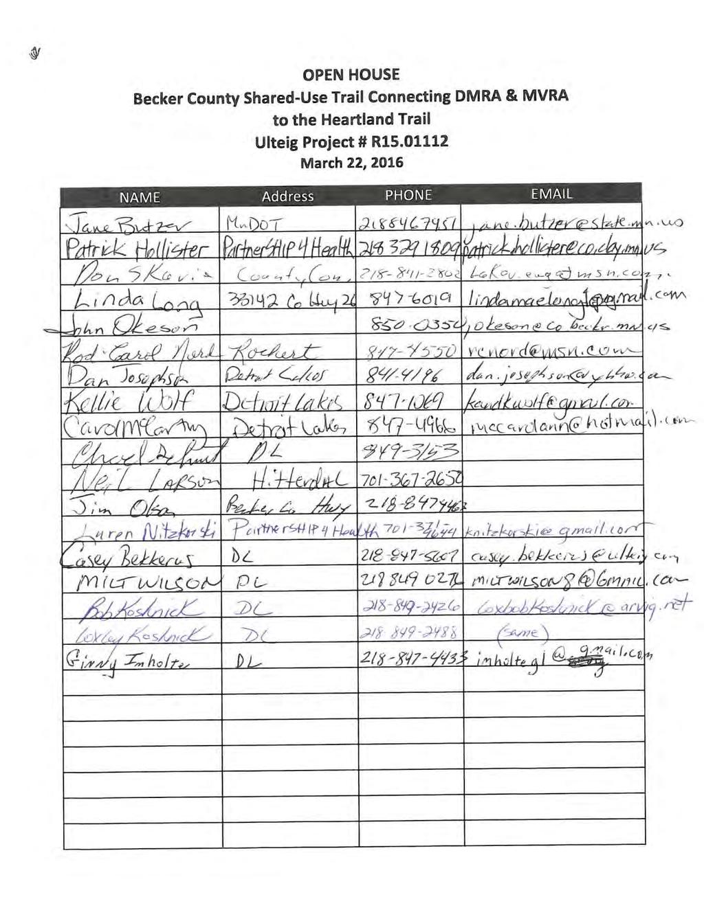
24 Becker County Shared-Use Trail Connecting DMRA & MVRA to the Heartland Trail Meeting Summary UEI Project No March 22, Attendees The Presenters were: Guy Fischer Becker County Tom Lundberg MnDOT Brian King Ulteig Casey Bekkerus Ulteig 17 people attended the open house. The attendee list/sign-in sheet is attached to the end of the document. 2. Comment Sheets Comment Sheets were provided to gather feedback. One comment sheet was completed and returned during the Open House. It was an anonymous submittal that read Safety for families is critical along the entire route AND at the road crossings. 3. Public s Questions & Concerns Concerns were raised about the Big Picture and the intent of the connecting trail. The overall concern was that the MVRA would become private and passes would be required. This study is only intended to connect the two recreational areas to each other and the Heartland Trail in the most efficient way. This study does not intend to change any of the uses inside the actual recreational areas. The questions about if cross country skiing and the motorized electric wheelchair/scooter would fall under the definition of shared-use was asked. The cross country skiing answer is not known at this time due to that agreements that would be required for grooming during the ski season. The trail will be ADA accessible so it is presumed that motorized electric wheelchair/scooters would be allowed. Will horseback riding be allowed on the path? At this time horseback riding will not be allowed on the paved trail. The speed limit on County 54 in the area where the trail would cross County 54 onto Tower road is 45 MPH. Permanent and temporary Easements will be required for this project. Wetlands will be avoided where possible. Will this project eliminate the snowmobile trail access along Hwy 10 from the underpass to the County 54 RR Crossing? At this time the is belief that an agreement will be reached for that portion of the trail that the two trails can coexist and snowmobile access will not be impacted by this project. 4. Public Comments on Route Options Route 3 through Hidden Hills was deemed unfeasible due to the length and the anticipated resistance to acquiring the permanent easements required to connect to MVRA. Route 3 would be the most expensive to build and maintain. The county commissioners agreed that the consideration of maintaining and repairing the trail in the future needs to be made when identifying the preferred route. The comment was made that since the purpose of this trail is to get to the Heartland trail, the shortest route to the destination was recommended, which is Route 1 and/or Route 1A.
25 The comment was made that resale values of the homes with direct access to the trail will go up. That has been seen in other parts of the City of Detroit Lakes; another comment suggested that property values would go down (Hidden Hills - route 3 discussion). It appeared that Route 4 impacted the most wetlands and also US Fish and Wildlife Service Land, so people did not prefer that option. People agreed that the shortest route would be preferred for families wanting to make a quick family outing. Route 1 is approximately 2 Miles Comment made about the proposed trail surface crossing of Co. 54 from Tower Road per Route 1. Staff responded that a variety of options existed to increase the safety of that crossing including flashers. Comments made about current speed along 54 (40mph) and that it was fast. The question was asked about how many miles of existing bike trails exist within the city limits. Approximately 23 miles. The project cost, not include acquisition, is approximately $710,000. Submission for the next Greater MN Regional Parks and Trails Commission (GMRPTC) funding cycle is June/July. The goal is to apply for all, or part, of the trail system. Questions were asked about the status of the Heartland Trail. 5. Public Comment on the increase of Traffic on 305 th Ave One of the residents asked if any road/safety improvements were going to be made on 305 th Ave. He was wondering if traffic counts were completed. A combination of the rolling terrain, the condition of the gravel road and the increase in traffic has made that stretch of road more dangerous. He was urged to bring this to the attention of the township since it is a township road so they can approach the county.
26
27
Longmont to Boulder Regional Trail Jay Road Connection DRAFT FINAL REPORT
 Longmont to Boulder Regional Trail Jay Road Connection DRAFT FINAL REPORT December 2018 Project Summary Boulder County, Colorado, in partnership with the City of Boulder, is evaluating options for multi-use
Auburn Trail / Ontario Pathways Trail Connector Feasibility Study Public Information Meeting Wednesday, August 22, 2012
 Auburn Trail / Ontario Pathways Trail Connector Feasibility Study Public Information Meeting Wednesday, August 22, 2012 Purpose of Feasibility Study Purpose Evaluate the feasibility of constructing a multiuse
FEASIBILITY CRITERIA
 This chapter describes the methodology and criteria used to evaluate the feasibility of developing trails throughout the study areas. Land availability, habitat sensitivity, roadway crossings and on-street
2. Goals and Policies. The following are the adopted Parks and Trails Goals for Stillwater Township:
 D. PARKS AND TRAILS 1. Introduction Stillwater Township s population is relatively low, with most residents living on rural residences on large lots. The need for active park space has been minimal in
Non-Motorized Transportation
 Non-Motorized Transportation Non-motorized facilities are important components to the transportation system. They provide an environmentally-friendly, low-cost mode of travel. Some of the facilities can
Blueways: Rivers, lakes, or streams with public access for recreation that includes fishing, nature observation, and opportunities for boating.
 Parks, Open Space and Trails PRINCE WILLIAM COUNTY 2008 COMPREHENSIVE PLAN TRAILS PLAN CONTENTS The components of the trails plan are: Intent Definitions Goals, Policies, and Action Strategies Trails Map
AGENDA ITEM 5 D WAKULLA ENVIRONMENTAL INSTITUTE (WEI) TRAIL FEASIBILITY STUDY
 TRAIL FEASIBILITY STUDY") March 19, 2018 AGENDA ITEM 5 D WAKULLA ENVIRONMENTAL INSTITUTE (WEI) TRAIL FEASIBILITY STUDY TYPE OF ITEM: Action STATEMENT OF ISSUE The Wakulla Environmental Institute (WEI) Trail is one of several trails
March 19, 2018 AGENDA ITEM 5 D WAKULLA ENVIRONMENTAL INSTITUTE (WEI) TRAIL FEASIBILITY STUDY TYPE OF ITEM: Action STATEMENT OF ISSUE The Wakulla Environmental Institute (WEI) Trail is one of several trails
MEETING MINUTES District 1 Trail Planning Meeting 1
 MEETING MINUTES District 1 Trail Planning Meeting 1 June 1, 2017 2:00 PM 3:30 PM City of Two Harbors 2:00 Introductions Attendees: Lisa Austin, MnDOT Bryan Anderson, MnDOT Jasna Hadzic-Stanek, MnDOT Justin
City of Durango 5.8 FUNDING TRAILS DEVELOPMENT
 5.8 FUNDING TRAILS DEVELOPMENT The City has been successful in establishing dedicated local funding sources as well as applying for grants to develop the City s trail system, having received nearly $2.4
The Baker/Carver Regional Trail is intended to
 Section V Design Guidance The Baker/Carver Regional Trail is intended to safely accommodate 183,000 annual visits, an array of non-motorized uses, a variety of skill levels, and persons with special needs.
Rule Governing the Designation and Establishment of All-Terrain Vehicle Use Trails on State Land
 Rule Governing the Designation and Establishment of All-Terrain Vehicle Use Trails on State Land 1.0 Authority 1.1 This rule is promulgated pursuant to 23 V.S.A. 3506. Section 3506 (b)(4) states that an
Segment 2: La Crescent to Miller s Corner
 goal of the USFWS refuges is to conserve, protect and enhance fish, wildlife and plants and their habitats for the continuing benefit of the American people. Refuge lands are used largely for fishing,
Business Item No
 Metropolitan Parks and Open Space Commission Meeting date: February 6, 2018 For the Community Development Committee meeting of February 20, 2018 For the Metropolitan Council meeting of February 28, 2018
Trail # NW Tuesday, June DESIGN. Provide an Review the Provide an. Project Goals: System system. wayfinding
 I. Welcome / Introductions Bethany Creek Trail #2 Segment 3 Neighborhood Meeting #1 Bethany Presbyterian Church 15505 NW Springville Road, Portland, OR 97229 Tuesday, June 26, 2018 @ 6:00PM Meeting Minutes
University Region Non-Motorized Plan 2015
 Non-Motorized Transportation Non-motorized facilities are important components to the transportation system. They provide an environmentally-friendly, low-cost mode of travel. Some of the facilities can
HIGHWAY RAIL GRADE CROSSING CONSOLIDATION PROGRAM
 HIGHWAY RAIL GRADE CROSSING CONSOLIDATION PROGRAM To decrease unnecessary train traffic exposure to life and property, promote public safety, and improve traffic conditions, the Texas Department of Transportation
Business Item No XXX. Proposed Action That the Metropolitan Council approve the Coon Creek Regional Trail Master Plan.
 Business Item No. 2015-XXX Metropolitan Parks and Open Space Commission Meeting date: July 7, 2015 For the Community Development Committee meeting of July 20, 2015 For the Metropolitan Council meeting
Community Development Committee
 C Community Development Committee For the Metropolitan Council meeting of October 31, 2012 Committee Report Item:2012-316 ADVISORY INFORMATION October 16, 2012 Date Prepared: Subject: Intercity Regional
Citrus Heights Creek Corridor Trail Project Trail Advisory Group Field Trip #2 September 11, :00 11:00 am Trellis Hall, Citrus Heights
 September 11, 2013 9:00 11:00 am Trellis Hall, Citrus Heights Project Overview The City of Citrus Heights is studying the feasibility of establishing a multi use trail system within the City s 26 miles
FINAL. Bicycle/Pedestrian Feasibility Study City of DeBary Dirksen Drive Trail. Prepared For: Volusia County MPO
 City of DeBary Dirksen Drive Trail FINAL Prepared By: Reynolds, Smith and Hills, Inc. Prepared For: Volusia County MPO September 2007 Table of Contents INTRODUCTION...1 PROJECT PURPOSE AND SCOPE...2 PHYSICAL
Understanding user expectations And planning for long term sustainability 1
 Understanding user expectations And planning for long term sustainability 1 What is a natural surface trail? It can be as simple has a mineral soil, mulched or graveled pathway, or as developed as elevated
Attachment No. 20 RRLRT No. 1. Committee. Busway Grade Crossings STATUS/DATE OF ACTION
 Attachment No. 20 RRLRT No. 1 TECHNICAL COMMITTEE: Railroad / Light Rail Transit Technical Committee TOPIC: Busway Grade Crossings STATUS/DATE OF ACTION RRLRT TC Draft: 06/23/2011 RRLRT TC Approval: 06/27/2014
Blue River Trail Master Plan JSA to Town Hall June 2004
 Blue River Trail Master Plan JSA to Town Hall June 2004 Prepared for: Silverthorne Town Council Silverthorne SPORT Committee Department of Recreation and Culture Silverthorne Public Works Silverthorne
METROPOLITAN COUNCIL 390 North Robert Street, St. Paul, MN Phone (651) TDD (651)
 TDD (651)") METROPOLITAN COUNCIL 390 North Robert Street, St. Paul, MN 55101 Phone (651) 602 1000 TDD (651) 291 0904 DATE: June 19, 2007 TO: Metropolitan Parks and Open Space Commission FROM: Jan Youngquist, Senior
METROPOLITAN COUNCIL 390 North Robert Street, St. Paul, MN 55101 Phone (651) 602 1000 TDD (651) 291 0904 DATE: June 19, 2007 TO: Metropolitan Parks and Open Space Commission FROM: Jan Youngquist, Senior
Stage 2 ION: Light Rail Transit (LRT) from Kitchener to Cambridge
 from Kitchener to Cambridge") Stage 2 ION: Light Rail Transit (LRT) from Kitchener to Cambridge Public Consultation Centre (PCC) No. 3 Please Sign-in Cambridge City Hall November 21, 2017 2:00 to 8:00pm Preston Memorial Auditorium
Stage 2 ION: Light Rail Transit (LRT) from Kitchener to Cambridge Public Consultation Centre (PCC) No. 3 Please Sign-in Cambridge City Hall November 21, 2017 2:00 to 8:00pm Preston Memorial Auditorium
ANCLOTE COASTAL TRAIL ALTERNATIVES ANALYSIS STUDY
 ANCLOTE COASTAL TRAIL ALTERNATIVES ANALYSIS STUDY PASCO COUNTY MPO JULY 2015 PROJECT OVERVIEW... INTRODUCTION EXECUTIVE SUMMARY CONTEXT... TAMPA BAY AREA, PINELLAS, & PASCO COUNTY S MULTI-USE TRAIL PLANS
The Chu property is a 6.57 acre parcel located in the Town of Superior on the west side of McCaslin Boulevard. In 2014, the Town of Superior acquired
 1 The Chu property is a 6.57 acre parcel located in the Town of Superior on the west side of McCaslin Boulevard. In 2014, the Town of Superior acquired the Chu property for open space with a contribution
MORGAN CREEK GREENWAY Final Report APPENDICES
 APPENDICES MORGAN CREEK GREENWAY Appendix A Photos of Existing Conditions in Trail Corridor Photos of existing conditions Main trail corridor - February 2009 Photos of existing conditions south bank Morgan
C. APPROACH FOR IDENTIFYING THE BEST ROUTES FOR THE NEEDED TRANSMISSION SYSTEM IMPROVEMENTS
 C. APPROACH FOR IDENTIFYING THE BEST ROUTES FOR THE NEEDED TRANSMISSION SYSTEM IMPROVEMENTS CL&P s approach for identifying the best routes for the needed transmission system improvements included a determination
Mt. Hood National Forest
 United States Department of Agriculture Forest Service Mt. Hood National Forest Zigzag Ranger District 70220 E. Highway 26 Zigzag, OR 97049 503-622-3191 Fax: 503-622-5622 File Code: 1950-1 Date: June 29,
Committee Report. Community Development Committee For the Metropolitan Council meeting of April 13, Business Item No.
 Committee Report Business Item No. 2016-48 Community Development Committee For the Metropolitan Council meeting of April 13, 2016 Subject: Harriet Island-South St. Paul Regional Trail Master Plan, Saint
Railroad Safety Trail
 2.1 INTRODUCTION AND PROJECT SETTING 2.1 Introduction & Project Setting Introduction This study is the result of a directed effort on the part of the City of San Luis Obispo to carry out previously established
3. COLTA / HUGA CONNECTIONS - PRELIMINARY
 9 3. COLTA / HUGA CONNECTIONS - PRELIMINARY 3.1 COLTA The Chain of Lakes Trail Association (COLTA) trail, formerly identified as the Chester Spur Line, was completed and opened for use in June 2011. The
Georgetown-Lewes Rail/Trail Study. Rail/Trail Study: Cool Spring to Cape Henlopen State Park New Road Extension (House Resolution No.
 Georgetown-Lewes Rail/Trail Study Rail/Trail Study: Cool Spring to Cape Henlopen State Park New Road Extension (House Resolution No. 47) August 22, 2011 Presentation Outline Background Benefits Statewide
K SIGNAGE & TRAFFIC CONTROL. Table of Contents
 Table of Contents K1. ACCOMMODATION OF TRAFFIC... 1 K2. MINIMUM CONSTRUCTION SIGNING... 1 K3. SUBDIVISION SIGNS... 2 K4. TRAFFIC CONTROL DEVICES... 2 K4.1 Traffic Signs Regulations... 2 K4.2 Materials...
URBAN DESIGN REPORT. Proposed Residential Development, Old Church Road, Caledon East
 Proposed Residential Development, Old Church Road, Caledon East TABLE CONTENTS: 1.0 DEVELOPMENT 1.1 Introduction-Analysis of Guiding Principles and Documents 1.2 Community Design and Architectural Design
Peter Axelson. Beneficial Designs, Inc. Minden, NV
 Peter Axelson Beneficial Designs, Inc. Minden, NV Arroya Sit Ski Mono Ski Dynamic Seating Spring Assist Cross Country Ski Hand Bike Adaptive Canoe Seating Available from Chosen Valley Canoe Accessories
Environment and Natural Resources Trust Fund (ENRTF) M.L ENRTF Work Plan (Main Document)
 M.L ENRTF Work Plan (Main Document)") Environment and Natural Resources Trust Fund (ENRTF) M.L. 2018 ENRTF Work Plan (Main Document) Today s Date: December 8, 2017 Date of Next Status Update Report: January 31, 2019 Date of Work Plan Approval:
Environment and Natural Resources Trust Fund (ENRTF) M.L. 2018 ENRTF Work Plan (Main Document) Today s Date: December 8, 2017 Date of Next Status Update Report: January 31, 2019 Date of Work Plan Approval:
Macleod Trail Corridor Study. Welcome. Macleod Trail Corridor Study Open House. Presentation of Proposed Design Concepts
 Macleod Trail Corridor Study Welcome Macleod Trail Corridor Study Open House Presentation of Proposed Design Concepts Study Purpose Develop a corridor plan for Macleod Trail that aligns with The City s:
Chapter 6: POLICY AND PROCEDURE RECOMMENDATIONS
 Chapter 6 POLICY AND PROCEDURE RECOMMENDATIONS FOR SRRA Below are seven policy elements that should be considered for adoption by the Southwest Regional Recreation Authority of Virginia: 1. Develop strategies
1803 West Hwy 160 Monte Vista, CO (719) TTY (719)
 TTY (719)") USDA Forest Service Rio Grande National Forest http://www.fs.fed.us/r2/riogrande 1803 West Hwy 160 Monte Vista, CO 81144 (719)852-5941 TTY (719)852-6271 USDI Bureau of Land Management San Luis Valley Center
USDA Forest Service Rio Grande National Forest http://www.fs.fed.us/r2/riogrande 1803 West Hwy 160 Monte Vista, CO 81144 (719)852-5941 TTY (719)852-6271 USDI Bureau of Land Management San Luis Valley Center
Susitna-Watana Hydroelectric Project (FERC No ) Recreation Resources Study Study Plan Section Study Implementation Report
 Recreation Resources Study Study Plan Section Study Implementation Report") (FERC No. 14241) Recreation Resources Study Study Plan Section 12.5 2014 Study Implementation Report Prepared for Prepared by AECOM November 2015 TABLE OF CONTENTS 1. Introduction... 4 2. Study Objectives...
(FERC No. 14241) Recreation Resources Study Study Plan Section 12.5 2014 Study Implementation Report Prepared for Prepared by AECOM November 2015 TABLE OF CONTENTS 1. Introduction... 4 2. Study Objectives...
Committee Report. Community Development Committee For the Metropolitan Council meeting of August 12, Business Item No.
 Committee Report Business Item No. 2015-168 Community Development Committee For the Metropolitan Council meeting of August 12, 2015 Subject: Coon Creek Regional Trail Master Plan, Anoka County Proposed
At the time, the portion of the line through Eagle County remains wholly under the ownership of Union Pacific Railroad (UP).
.") Chapter 5 The Railroad Corridor as a Trail Corridor The intent of this chapter is to identify how the rail corridor, if available for lease or purchase in all or part, could be incorporated into the core
Chapter 5 The Railroad Corridor as a Trail Corridor The intent of this chapter is to identify how the rail corridor, if available for lease or purchase in all or part, could be incorporated into the core
RUSHMORE CONNECTOR TRAIL PROPOSAL
 PURPOSE AND NEED Background The U.S. Forest Service, Black Hills National Forest (Forest Service) has received a special use permit application from the State of South Dakota Department of Game, Fish and
Preferred Recreation Recommendations Stemilt-Squilchuck Recreation Plan March 2018
 Preferred Recreation Recommendations Stemilt-Squilchuck Recreation Plan March 2018 Below are the recommended recreation ideas and strategies that package together the various recreation concepts compiled
CHAPTER III: TRAIL DESIGN STANDARDS, SPECIFICATIONS & PERMITS
 CHAPTER III Trail Design Standards, Specifications & Permits This chapter discusses trail standards, preferred surface types for different activities, permits, and other requirements one must consider
2016 Regional Transportation Alternatives Program (TAP) Grant Application
 Grant Application") 2016 Regional Transportation Alternatives Program (TAP) Grant Application PROJECT TITLE: Yelm-Tenino Trail Extension Feasibility Study TRPC use only GENERAL PROJECT INFORMATION Agency or Organization City
2016 Regional Transportation Alternatives Program (TAP) Grant Application PROJECT TITLE: Yelm-Tenino Trail Extension Feasibility Study TRPC use only GENERAL PROJECT INFORMATION Agency or Organization City
Little River Trail Feasibility Study
 Final April, 2014 Prepared for the State Coastal Conservancy By the Natural Resources Services Division of Redwood Community Action Agency Table of Contents Executive Summary... 1 1. Project Purpose and
White Mountain National Forest Saco Ranger District
 United States Department of Agriculture Forest Service White Mountain National Forest Saco Ranger District 33 Kancamagus Highway Conway, NH 03818 Comm: (603) 447-5448 TTY: (603) 447-3121 File Code: 1950
Welcome to the Cross County Trail Public Input Session!
 Welcome to the Cross County Trail Public Input Session! Please sign in on the table below! What are we doing here? Camden County has proposed a bicycle and pedestrian trail spanning across the entire county.
Thornton Water Project. Larimer County Route Study and Project Update September 12, 2017
 Thornton Water Project Larimer County Route Study and Project Update September 12, 2017 Purpose of Meeting Provide information on the Thornton Water Project Present the results of the pipeline routing
CHAPTER 1: INTRODUCTION
 CHAPTER 1: INTRODUCTION Purpose and Scope The information presented in this report represents the study findings for the 2016 Ronan Airport Master Plan prepared for the City of Ronan and Lake County, the
CHAPTER 6 NOISE EXPOSURE
 CHAPTER 6 NOISE EXPOSURE FAA requires that the NEM submitted for review represent the aircraft noise exposure for the year of submittal (in this case 2008) and for a future year (2013 for OSUA). However,
ALBANY-HUDSON ELECTRIC TRAIL FEASIBILITY STUDY. Final Report OCTOBER 2011
 ALBANY-HUDSON ELECTRIC TRAIL FEASIBILITY STUDY Final Report OCTOBER 2011 ALBANY-HUDSON ELECTRIC TRAIL FEASIBILITY STUDY Prepared for: Town of East Greenbush 225 Columbia Turnpike Rensselaer, New York 12144
4. Safety Concerns Potential Short and Medium-Term Improvements
 NH Route 104 Access Management Study Page 19 4. Safety Concerns Potential Short and Medium-Term Improvements Potential safety improvement strategies are listed by priority based on field observations by
EAST DON TRAIL ENVIRONMENTAL ASSESSMENT. Community Liaison Committee Meeting #3 July 15, :30 to 8:30 pm Flemingdon Park Library
 EAST DON TRAIL ENVIRONMENTAL ASSESSMENT Community Liaison Committee Meeting #3 July 15, 2013 6:30 to 8:30 pm Flemingdon Park Library Agenda 1. Welcome 2. Housekeeping and Updates a) Housekeeping b) CLC
Section II. Planning & Public Process Planning for the Baker/Carver Regional Trail began in 2010 as a City of Minnetrista initiative.
 Section II Planning & Public Process Planning for the began in 2010 as a City of initiative. city staff began discussions with the Park District on the possibility of a north/south regional trail connection
United States Department of the Interior National Park Service. Boundary Expansion Listed in National Register January 11, 2017
 NPS Form 10900-a (Rev. 8/2002) OMB No. 10240018 United States Department of the Interior National Park Service Boundary Expansion Listed in National Register January 11, 2017 National Register of Historic
David Johnson. Tom, Attached please find the final scoping letter and figures for your review. David
 David Johnson From: Sent: To: Cc: Subject: Attachments: David Johnson Tuesday, April 12, 2011 4:33 PM Thomas Malecek Dave Dyer; Jason Marks (jmarks@segroup.com) VWC Scoping Letter
Laxon Terrace - Sarawia. Click to add title. Street Rail Level Crossing. Public Forum. December
 Laxon Terrace - Sarawia Click to add title Street Rail Level Crossing Public Forum December 2012 www.aucklandtransport.govt.nz Overview of Presentation Objectives and Reasons for Separation Project Background
Proposed Action. Payette National Forest Over-Snow Grooming in Valley, Adams and Idaho Counties. United States Department of Agriculture
 United States Department of Agriculture Forest Service January 2012 Proposed Action Payette National Forest Over-Snow Grooming in Valley, Adams and Idaho Counties Payette National Forest Valley, Adams
Grade Crossing Regulations
 Grade Crossing Regulations An Overview of Municipal Roles and Responsibilities at Federally Legislated Grade Crossings March 21, 2017 presentation to Alberta Municipal Supervisor Association, Edmonton,
COMMENT PERIOD INTRODUCTION
 To: Interested Persons From: Tom Buford File: Del Rio Trail Project Date: June 8, 2018 Community Development Department Reference: NOTICE OF PREPARATION OF AN ENVIRONMENTAL IMPACT REPORT FOR THE DEL RIO
NORTHEAST CARLTON COUNTY BICYCLE ROUTE PLAN
 NORTHEAST CARLTON COUNTY BICYCLE ROUTE PLAN 5/31/2014 and St. Louis River Trail Plan Update Produced by the Arrowhead Regional Development Commission (ARDC) in Partnership with the State Health Improvement
EXECUTIVE SUMMARY PROGRAM DEVELOPMENT REPORT PURPOSE EXISTING SETTING EXPANDING PARKLAND
 EXECUTIVE SUMMARY PROGRAM DEVELOPMENT REPORT PURPOSE As the culmination of the first phase of the master planning process, this Program Development Report creates the framework to develop the Calero County
Parkland County Municipal Development Plan Amendment Acheson Industrial Area Structure Plan
 Parkland County Municipal Development Plan Amendment Acheson Industrial Area Structure Plan New Plan Acheson Industrial Area Structure Plan Amendment Parkland County Municipal Development Plan Board Reference
WELCOME to the Iditarod Dog Sledding Historic District (IDSHD) Workshop. January 11, Houston Middle School Houston, Alaska
 Workshop. January 11, Houston Middle School Houston, Alaska") WELCOME to the Iditarod Dog Sledding Historic District (IDSHD) Workshop January 11, 2012 Houston Middle School Houston, Alaska Workshop Purpose: Present/discuss proposed resolutions to comments received
WELCOME to the Iditarod Dog Sledding Historic District (IDSHD) Workshop January 11, 2012 Houston Middle School Houston, Alaska Workshop Purpose: Present/discuss proposed resolutions to comments received
Aspen Skiing Company Policy for Use of Other Power-Driven Mobility Devices And Service Animals
 Aspen Skiing Company Policy for Use of Other Power-Driven Mobility Devices And Service Animals Introduction New rules under the Americans with Disabilities Act (ADA), Titles II and III, went into effect
Lake Apopka Trail Loop Design Guidelines
 November 2002 Prepared for 14908 Tilden Road Winter Garden, FL 34787 Prepared by 140 North Orlando Avenue Suite 295 Winter Park, FL 32789 November, 2002 I. INTRODUCTION...1 II. DESIGN GUIDELINES FOR TRAILS...3
DATE: 23 March, 2011 TO: Communities FROM: BlazeSports America. RE: Accessible Trails Checklist 1
 M E M O R A N D U M DATE: 23 March, 2011 TO: Communities FROM: BlazeSports America RE: Accessible Trails Checklist 1 The purpose of the Accessible Trails Checklist (below) is to help the community review
Auburn Trail/Ontario Pathways Trail Connector Feasibility Study Project Advisory Group Meeting August 25, 2011 Farmington Town Hall Approved Minutes
 Auburn Trail/Ontario Pathways Trail Connector Feasibility Study Project Advisory Group Meeting August 25, 2011 Farmington Town Hall Approved Minutes Committee Members Attending: Ronald L. Brand, Director
PURPOSE AND NEED (CONCURRENCE POINT 1) NEW CANADA ROAD PROJECT FROM STATE ROUTE 1 (U.S. HIGHWAY 70) TO U.S. INTERSTATE 40
 NEW CANADA ROAD PROJECT FROM STATE ROUTE 1 (U.S. HIGHWAY 70) TO U.S. INTERSTATE 40") PURPOSE AND NEED (CONCURRENCE POINT 1) NEW CANADA ROAD PROJECT FROM STATE ROUTE 1 (U.S. HIGHWAY 70) TO U.S. INTERSTATE 40 Project Description The primary purpose of this project is to improve the major
PURPOSE AND NEED (CONCURRENCE POINT 1) NEW CANADA ROAD PROJECT FROM STATE ROUTE 1 (U.S. HIGHWAY 70) TO U.S. INTERSTATE 40 Project Description The primary purpose of this project is to improve the major
Trail Feasibility Study
 VOLUSIA COUNTY MPO CITY OF NEW SMYRNA BEACH FINAL REPORT JUNE 30, 2009 Trail Feasibility Study What s inside? 1 Introduction 2 Project Purpose & Scope 3 Physical Inventory & Assessment of Right-of- Way
Tallahassee-St. Marks Historic Railroad Trail
 Revitalizing a Historic Trail Designated as a National Recreation Trail, the 16-mile Tallahassee-St. Marks Historic Railroad Trail has been enjoyed by countless bicyclists, runners, and outdoor enthusiasts
APPENDIX F List of Commitments
 APPENDIX F List of Commitments s Table F.1 Standard Mitigation Measures Mitigation Measure MnDOT Specification Number Status Update Description Status Update Utilities Provide early notice to utility operators
A Master Plan is one of the most important documents that can be prepared by an Airport.
 The Master Plan A Master Plan is one of the most important documents that can be prepared by an Airport. A Master Plan is a visionary and a strategic document detailing planning initiatives for the Airport
Emily to Blind Lake Trail PROPOSED TRAIL DEVELOPMENT APPLICATION SUMMARY
 Emily to Blind Lake Trail PROPOSED TRAIL DEVELOPMENT APPLICATION SUMMARY Township 137 Range 26 (Fairfield Township) sections 2 & 3 Township 138 Range 26 (City of Emily) sections 27, 34, 35, & 36 Township
Outdoor Developed Areas
 The United States Access Board is an independent federal agency that promotes equality for people with disabilities through leadership in accessible design and the development of accessibility guidelines
What s covered. What s not covered. Options for those not covered. ABA Coverage
 The United States Access Board is an independent federal agency that promotes equality for people with disabilities through leadership in accessible design and the development of accessibility guidelines
Policies, Guidelines, and Standards for Trails in Alberta Highway Rights-of-way
 Policies, Guidelines, and Standards for Trails in Alberta Highway Rights-of-way Author/Presenter, Sean Willis, P.Eng., Transportation Associate, Stantec Consulting Ltd. Co-Author/Presenter, Steve Otto,
JOSLIN FIELD, MAGIC VALLEY REGIONAL AIRPORT DECEMBER 2012
 1. Introduction The Federal Aviation Administration (FAA) recommends that airport master plans be updated every 5 years or as necessary to keep them current. The Master Plan for Joslin Field, Magic Valley
Lake Erie Commerce Center Traffic Analysis
 LOCATION: East of NYS Route 5 at Bayview Road Town of Hamburg Erie County, New York PREPARED BY: Wendel Companies 140 John James Audubon Parkway Suite 200 Amherst, New York 14228 January 2012 i ii Table
FINAL TESTIMONY 1 COMMITTEE ON RESOURCES UNITED STATES HOUSE OF REPRESENTATIVES. July 13, 2005 CONCERNING. Motorized Recreational Use of Federal Lands
 FINAL TESTIMONY 1 STATEMENT OF DALE BOSWORTH CHIEF Of the FOREST SERVICE UNITED STATES DEPARTMENT OF AGRICULTURE Before the SUBCOMMITTEE ON FORESTS AND FOREST HEALTH And the SUBCOMMITTEE ON NATIONAL PARKS,
Those with Interest in the City of Cambridge Trail System
 Community Services Department City Hall 50 Dickson Street, P.O. Box 669 Cambridge ON N1R 5W8 Tel: 519-740-4681 July 20, 2010 To: Re: Those with Interest in the City of Cambridge Trail System City of Cambridge
March 4, Mr. H. Dale Hemmerdinger Chairman Metropolitan Transportation Authority 347 Madison Avenue New York, NY Re: Report 2007-F-31
 THOMAS P. DiNAPOLI STATE COMPTROLLER 110 STATE STREET ALBANY, NEW YORK 12236 STATE OF NEW YORK OFFICE OF THE STATE COMPTROLLER March 4, 2008 Mr. H. Dale Hemmerdinger Chairman Metropolitan Transportation
Committee. Presentation Outline
 CW-33-15 11/9/2015 Community and Corporate Services Committee November 10, 2015 1 Presentation Outline Background Vision and Objectives Study Process and Timeline Public and Stakeholder Engagement Organization
Public Notice ISSUED: December 10, 2018 EXPIRES: January 9, 2019
 APPLICANT: REFER TO: St. Louis and Lake Counties Regional Rail Authority 2018-01942-ARC Public Notice ISSUED: December 10, 2018 EXPIRES: January 9, 2019 SECTION:404 - Clean Water Act 1. APPLICATION FOR
Construction Staging Adelaide Street West
 REPORT FOR ACTION Construction Staging Adelaide Street West Date: October 6, 2016 To: Toronto and East York Community Council From: Acting Director, Transportation Services, Toronto and East York District
Keeping Fun Safe. A public discussion paper on a new Amusement Ride Regulation for Manitoba
 Keeping Fun Safe A public discussion paper on a new Amusement Ride Regulation for Manitoba October 2016 This information is available in alternate formats upon request. 2 Overview: The Government of Manitoba
Agenda: SASP SAC Meeting 3
 Agenda: SASP SAC Meeting 3 Date: 04/12/18 Public Involvement Plan Update Defining the System Recommended Classifications Discussion Break Review current system Outreach what we heard Proposed changes Classification
SR 934 Project Development And Environment (PD&E) Study
 Study") SR 934 Project Development And Environment (PD&E) Study Project Advisory Group Meeting March 1, 2018 State Road 934/NE/NW 79th Street from west of I-95 (NW 13th CT) to N. Bayshore Drive PD&E STUDY SR 934/NE/NW
SR 934 Project Development And Environment (PD&E) Study Project Advisory Group Meeting March 1, 2018 State Road 934/NE/NW 79th Street from west of I-95 (NW 13th CT) to N. Bayshore Drive PD&E STUDY SR 934/NE/NW
DRAFT - APRIL 13, 2007 ROUTING STUDY FOR TRAIL CONNECTIONS BETWEEN CALAIS AND AYERS JUNCTION
 DRAFT - APRIL 13, 2007 ROUTING STUDY FOR TRAIL CONNECTIONS BETWEEN CALAIS AND AYERS JUNCTION Abstract The vision for the East Coast Greenway is an off-road urban trail system running from Calais, Maine
Arvidson, Adam R. Adam,
 Arvidson, Adam R. From: Andrew Hestness Sent: Wednesday, May 18, 2016 5:39 PM To: Arvidson, Adam R. Cc: Renee Spillum; Schroeder, Michael Subject: RE: Park Dedication Attachments: FranklinPlan - Bystrom
BUTTE COUNTY FOREST ADVISORY COMMITTEE
 BUTTE COUNTY FOREST ADVISORY COMMITTEE November 24, 2014-4:00 P.M. ITEM NO. 1.00 2.00 Call to order Golden Valley Bank, 190 Cohasset Rd. Chico, CA 95926 (park in center of lot) Pledge of allegiance to
Environment and Natural Resources Trust Fund 2019 Request for Proposals (RFP)
") Environment and Natural Resources Trust Fund 2019 Request for Proposals (RFP) Project Title: Glacial Edge Trail and Downtown Pedestrian Bridge Category: G. Land Acquisition for Habitat and Recreation ENRTF
Environment and Natural Resources Trust Fund 2019 Request for Proposals (RFP) Project Title: Glacial Edge Trail and Downtown Pedestrian Bridge Category: G. Land Acquisition for Habitat and Recreation ENRTF
Project Deliverable 4.1.3d Individual City Report - City of La Verne
 Pomona Valley ITS Project Project Deliverable 4.1.3d Individual City Report - City of La Verne Prepared by: April 19, 2002 099017000.1 Copyright 2002, Kimley-Horn and Associates, Inc TABLE OF CONTENTS
A CASE FOR COMPLETING THE JORDAN RIVER PARKWAY: A
 A CASE FOR COMPLETING THE JORDAN RIVER PARKWAY: A safe crossing at 9000 South and 850 West Proposed 9000 South Underpass Parkway Timeline Parkway, Trail, and Tourism Facts Blueprint Jordan River 1971 1973
Section 3-04 Cross Sectional Elements TABLE OF CONTENTS. INTRODUCTION...3 General...3 Exhibit 1-Cross-Sectional Elements...3
 Section 3-04 Cross Sectional Elements TABLE OF CONTENTS INTRODUCTION...3 General...3 Exhibit 1-Cross-Sectional Elements...3 CROSS-SECTIONAL ELEMENTS...3 Traveled Way...3 Shoulder...3 Surfacing Taper...3
Tracy Ridge Shared Use Trails and Plan Amendment Project
 Tracy Ridge Shared Use Trails and Plan Amendment Project Scoping Document Forest Service Allegheny National Forest Bradford Ranger District McKean, County, Pennsylvania In accordance with Federal civil