Figure 1: Little Dry Creek Trail Crossing
|
|
|
- Samuel Gardner
- 5 years ago
- Views:
Transcription


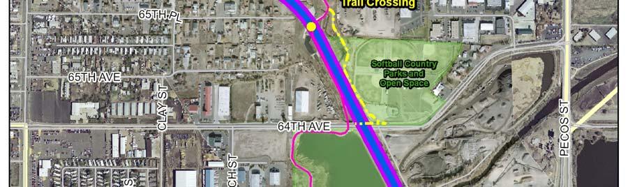
1 Figure 1: Little Dry Creek Trail Crossing
2 Figure 2: Little Dry Creek Trail Crossing
3 Northwest Rail Environmental Evaluation Temporary Trail Detour Concurrence Form Adams County, Little Dry Creek Trail Request for Concurrence Please sign this document at your earliest convenience. It will serve as Adams County s concurrence that it finds that the requirements of a temporary occupancy, as outlined in the letter dated January 22, 2010 (Attached), are met. This signed acknowledgement is a coordination element which is part of the Northwest Rail Environmental Evaluation. Please return the letter by to chris.proud@ch2m.com or fax it to (720) Jeanne Shreve Adams County Date
4
5 April 15, 2010 Jeanne Shreve Adams County Transportation Coordinator Pecos Street Westminster, CO Subject: Northwest Rail Environmental Evaluation, Consultation for Temporary Trail Detour Dear Ms. Shreve, The United States Army Corps of Engineers (USACE), in coordination with the Regional Transportation District (RTD), is preparing an Environmental Evaluation (EE) for the proposed Northwest Rail commuter line (NWR). As part of our ongoing coordination, we are submitting this letter to you as our primary contact for the project to inform you of potential impacts to park resources under the jurisdiction of Adams County. In January 2010 we submitted a letter documenting the potential impacts and mitigation measures for the Little Dry Creek Trail. Additional impacts have been identified for the 64 th Avenue overcrossing, and this letter documents those potential impacts and mitigation measures. An overview of the anticipated impacts and proposed mitigation measures is provided below. As part of the Preferred Alternative, a second railroad track would be constructed to provide both freight and commuter rail service adjacent to the existing Burlington Northern Santa Fe (BNSF) Railway Company line between Denver Union Station and Longmont. The Little Dry Creek Trail currently passes under and adjacent to the BNSF railway where it intersects with the rail line and where it crosses under Federal Boulevard. The construction of the 64 th Avenue overcrossing would require the temporary closure of the 64 th Avenue trail undercrossing and the trails located west of the rail line, north and south of 64 th Avenue. While the track is being placed and the 64 th Avenue overcrossing is constructed, the existing crossings would need to be temporarily closed to all users for approximately 2 months. This temporary closure is necessary for the safety of the trail users and construction workers. The project is currently in the environmental clearance stage and a formal start date for construction has not been set. This letter serves to gain Adams County s concurrence on the proposed temporary trail detours. We appreciate your assistance in coordinating the appropriate approvals for the proposed temporary trail detours. This approval is requested for documentation in the EE document. As construction grows closer, additional coordination will be completed to confirm final details of the temporary closures.
6
7 Figure 1: Little Dry Creek Trail Crossing
8 Northwest Rail Environmental Evaluation Temporary Trail Detour Concurrence Form Adams County, Little Dry Creek Trail Request for Concurrence Please sign this document at your earliest convenience. It will serve as Adams County s concurrence that it finds that the requirements of a temporary occupancy, as outlined in the letter dated April 15, 2010 (Attached), are met. This signed acknowledgement is a coordination element which is part of the Northwest Rail Environmental Evaluation. Please return the letter by to epstein@pinyonenv.com or fax it to (303) Jeanne Shreve Adams County Date
9 City and County of Denver Coordination
10
11
12
13


14
15
16
17 City of Westminster Coordination
18
19
20
21
22
23 City of Longmont Coordination
24

25 DEPARTMENT OF PUBLIC WORKS & NATURAL RESOURCES ENGINEERING SERVICES DIVISION 385 Kimbark Street, Longmont, CO (303) / Fax # (303) paula.fitzgerald@ci.longmont.co.us Web site: TO: Chris Proud, NW Rail Team FROM: Paula Fitzgerald, Project Manager DATE: February 5, 2010 RE: Environmental Evaluation, Temporary Trail Detour Construction The City of Longmont Engineering Services Division has reviewed the proposal for the future NW Rail commuter line and has concerns with the plan as currently proposed. Any temporary trail detour would need to be coordinated well in advance of construction with City Natural Resources, Recreation and Engineering Services Divisions. We hope to work out the details of the detour, and provide communications to the community regarding the closure, at least several months in advance to avoid impacts to maintenance as well as recreational programs that may be scheduled at that time. Duration of trail closure would also need to be limited to the greatest extent possible. The proposed detour route directs recreational traffic onto very busy roads with few or no bike lanes and few or no off-street walks appropriate for this use. The existing Sunset bridge is very narrow with no ability for bike lanes. Ken Pratt Blvd / Hwy 119, is a high use / higher speed roadway with difficult crossing opportunities, numerous drive cuts and other issues for recreational users. An alternative route is necessary. Ideally, the existing pedestrian bridge west of the railroad bridge could be utilized for the detour. Trail users could then travel south on Price Road, east to Sherman and then northeast on Colorado Avenue. The detour could rejoin the St. Vrain trail on Pratt Parkway, on the east side of this road. This route, may need modifications in terms of temporary signage, bike lanes etc. to accommodate this use. Lower travel speeds and traffic volumes make this route preferred to the recreational cyclists. We appreciate the opportunity to review this proposed detour and look forward to a revised detour proposal.
26
27 February 8, 2010 Phil Greenwald Community Development, Transportation Planning Civic Center Complex 385 Kimbark Street Longmont, CO Subject: Northwest Rail Environmental Evaluation, Temporary Trail Detour Consultation Dear Mr. Greenwald, The United States Army Corps of Engineers (USACE), in coordination with the Regional Transportation District (RTD), is preparing an Environmental Evaluation (EE) for the proposed Northwest Rail commuter line (NWR). As part of our ongoing coordination, we are submitting this letter to you as our primary contact for the project to inform you of potential impacts to park resources under the jurisdiction of the City of Longmont. Potential impacts and mitigation measures are proposed for the St. Vrain Greenway Trail. An overview of the anticipated impacts and proposed mitigation measures is provided below. As part of the Preferred Alternative, a second railroad track would be constructed to provide both freight and commuter rail service adjacent to the existing Burlington Northern Santa Fe (BNSF) Railway Company between Denver Union Station and Longmont. The St. Vrain Greenway Trail currently passes under the BNSF railway where the rail line intersects with the St. Vrain River in the City of Longmont. A new railroad bridge would be built over the St. Vrain Greenway Trail at the existing Burlington Northern Santa Fe river crossing. During the construction of bridge, the existing trail would be temporarily rerouted from its current location. The trail would be temporarily closed to all users for approximately 2 to 4 weeks, and during this time a temporary detour will be used. This temporary closure is necessary for the safety of trail users and construction workers. The project is currently in the environmental clearance stage and a formal start date for construction has not been set. This letter serves to gain the City of Longmont s concurrence on the proposed temporary trail detour. We appreciate your assistance in coordinating the appropriate approvals for the proposed temporary trail detours. This approval is requested for documentation in the EE document. As construction grows closer, additional coordination will be completed to confirm final details of the temporary closure. During the construction of the additional track, the above-mentioned trail would be temporarily rerouted from its current location, and a temporary detour would be used. The proposed detour is presented in the attached Figure 1:
28 St. Vrain Trail Crossing: Exit the trail at Price Road Cross the St. Vrain River using the pedestrian bridge Travel south to State Highway 119 At State Highway 119, travel east to Sherman Drive Travel northeast to Colorado Avenue Travel east to Pratt Parkway Cross Pratt Parkway and travel north two-hundred feet, where the trail ties back in. Although this project is sponsored by the USACE and therefore does not require Section 4(f) parkland analysis, it important to RTD to coordinate local jurisdictions with potentially affected park or trail resources. We seek concurrence from the City of Longmont on the proposed temporary trail detour. A concurrence form for your signature is attached. If you have any additional questions please feel free to contact me at or chris.proud@ch2m.com. We appreciate your assistance with this project. Sincerely, Chris Proud Northwest Rail Team CH2M HILL 1515 Wazee Street, Suite 380 Denver, CO CC: Chris Quinn, RTD FasTracks Liz Telford, RTD FasTracks Wendy Wallach, RTD FasTracks
29 Figure 1: St. Vrain Greenway Trail
30 February 8, 2010 Phil Greenwald Community Development, Transportation Planning Civic Center Complex 385 Kimbark Street Longmont, CO Subject: Northwest Rail Environmental Evaluation, Temporary Trail Detour Consultation Dear Mr. Greenwald, The United States Army Corps of Engineers (USACE), in coordination with the Regional Transportation District (RTD), is preparing an Environmental Evaluation (EE) for the proposed Northwest Rail commuter line (NWR). As part of our ongoing coordination, we are submitting this letter to you as our primary contact for the project to inform you of potential impacts to park resources under the jurisdiction of the City of Longmont. Potential impacts and mitigation measures are proposed for the St. Vrain Greenway Trail. An overview of the anticipated impacts and proposed mitigation measures is provided below. As part of the Preferred Alternative, a second railroad track would be constructed to provide both freight and commuter rail service adjacent to the existing Burlington Northern Santa Fe (BNSF) Railway Company between Denver Union Station and Longmont. The St. Vrain Greenway Trail currently passes under the BNSF railway where the rail line intersects with the St. Vrain River in the City of Longmont. A new railroad bridge would be built over the St. Vrain Greenway Trail at the existing Burlington Northern Santa Fe river crossing. During the construction of bridge, the existing trail would be temporarily rerouted from its current location. The trail would be temporarily closed to all users for approximately 2 to 4 weeks, and during this time a temporary detour will be used. This temporary closure is necessary for the safety of trail users and construction workers. The project is currently in the environmental clearance stage and a formal start date for construction has not been set. This letter serves to gain the City of Longmont s concurrence on the proposed temporary trail detour. We appreciate your assistance in coordinating the appropriate approvals for the proposed temporary trail detours. This approval is requested for documentation in the EE document. As construction grows closer, additional coordination will be completed to confirm final details of the temporary closure. During the construction of the additional track, the above-mentioned trail would be temporarily rerouted from its current location, and a temporary detour would be used. The proposed detour is presented in the attached Figure 1:
31 St. Vrain Trail Crossing: Exit the trail at Price Road Cross the St. Vrain River using the pedestrian bridge Travel south to State Highway 119 At State Highway 119, travel east to Sherman Drive Travel northeast to Colorado Avenue Travel east to Pratt Parkway Cross Pratt Parkway and travel north two-hundred feet, where the trail ties back in. Although this project is sponsored by the USACE and therefore does not require Section 4(f) parkland analysis, it important to RTD to coordinate local jurisdictions with potentially affected park or trail resources. We seek concurrence from the City of Longmont on the proposed temporary trail detour. A concurrence form for your signature is attached. If you have any additional questions please feel free to contact me at or chris.proud@ch2m.com. We appreciate your assistance with this project. Sincerely, Chris Proud Northwest Rail Team CH2M HILL 1515 Wazee Street, Suite 380 Denver, CO CC: Chris Quinn, RTD FasTracks Liz Telford, RTD FasTracks Wendy Wallach, RTD FasTracks
32 Figure 1: St. Vrain Greenway Trail
33 February 8, 2010 Phil Greenwald Community Development, Transportation Planning Civic Center Complex 385 Kimbark Street Longmont, CO Subject: Northwest Rail Environmental Evaluation, Temporary Trail Detour Consultation Dear Mr. Greenwald, The United States Army Corps of Engineers (USACE), in coordination with the Regional Transportation District (RTD), is preparing an Environmental Evaluation (EE) for the proposed Northwest Rail commuter line (NWR). As part of our ongoing coordination, we are submitting this letter to you as our primary contact for the project to inform you of potential impacts to park resources under the jurisdiction of the City of Longmont. Potential impacts and mitigation measures are proposed for the St. Vrain Greenway Trail. An overview of the anticipated impacts and proposed mitigation measures is provided below. As part of the Preferred Alternative, a second railroad track would be constructed to provide both freight and commuter rail service adjacent to the existing Burlington Northern Santa Fe (BNSF) Railway Company between Denver Union Station and Longmont. The St. Vrain Greenway Trail currently passes under the BNSF railway where the rail line intersects with the St. Vrain River in the City of Longmont. A new railroad bridge would be built over the St. Vrain Greenway Trail at the existing Burlington Northern Santa Fe river crossing. During the construction of bridge, the existing trail would be temporarily rerouted from its current location. The trail would be temporarily closed to all users for approximately 2 to 4 weeks, and during this time a temporary detour will be used. This temporary closure is necessary for the safety of trail users and construction workers. The project is currently in the environmental clearance stage and a formal start date for construction has not been set. This letter serves to gain the City of Longmont s concurrence on the proposed temporary trail detour. We appreciate your assistance in coordinating the appropriate approvals for the proposed temporary trail detours. This approval is requested for documentation in the EE document. As construction grows closer, additional coordination will be completed to confirm final details of the temporary closure. During the construction of the additional track, the above-mentioned trail would be temporarily rerouted from its current location, and a temporary detour would be used. The proposed detour is presented in the attached Figure 1:
34 St. Vrain Trail Crossing: Exit the trail at Price Road Cross the St. Vrain River using the pedestrian bridge Travel south to State Highway 119 At State Highway 119, travel east to Sherman Drive Travel northeast to Colorado Avenue Travel east to Pratt Parkway Cross Pratt Parkway and travel north two-hundred feet, where the trail ties back in. Although this project is sponsored by the USACE and therefore does not require Section 4(f) parkland analysis, it important to RTD to coordinate local jurisdictions with potentially affected park or trail resources. We seek concurrence from the City of Longmont on the proposed temporary trail detour. A concurrence form for your signature is attached. If you have any additional questions please feel free to contact me at or chris.proud@ch2m.com. We appreciate your assistance with this project. Sincerely, Chris Proud Northwest Rail Team CH2M HILL 1515 Wazee Street, Suite 380 Denver, CO CC: Chris Quinn, RTD FasTracks Liz Telford, RTD FasTracks Wendy Wallach, RTD FasTracks
35 Figure 1: St. Vrain Greenway Trail
36
37 Adams County Coordination
38
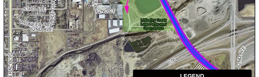
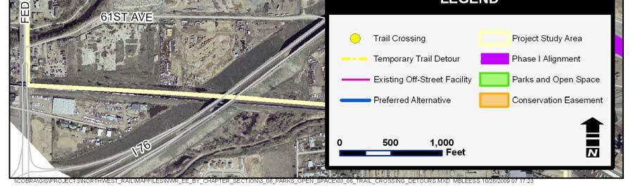
39 May 21, 2010 Marc Pedrucci Natural Resource Manager Adams County Parks & Community Resources Department 9755 Henderson Road Brighton, CO Subject: Northwest Rail Environmental Evaluation, Consultation for Temporary Trail Detour Dear Mr. Pedrucci, The United States Army Corps of Engineers (USACE), in coordination with the Regional Transportation District (RTD), is preparing an Environmental Evaluation (EE) for the proposed Northwest Rail commuter line (NWR). As part of our ongoing coordination, we are submitting this letter to you as our primary contact for the project to inform you of potential impacts to park resources under the jurisdiction of Adams County. In January 2010 we submitted a letter documenting the potential impacts and mitigation measures for the Little Dry Creek Trail. Additional impacts have been identified for the 64 th Avenue overcrossing, and this letter documents those potential impacts and mitigation measures. In addition, mitigation measures recommended in your May 20, 2010 letter are included in this letter. An overview of the anticipated impacts and proposed mitigation measures is provided below. As part of the Preferred Alternative, a second railroad track would be constructed to provide both freight and commuter rail service adjacent to the existing Burlington Northern Santa Fe (BNSF) Railway Company line between Denver Union Station and Longmont. The Little Dry Creek Trail currently passes under and adjacent to the BNSF railway where it intersects with the rail line and where it crosses under Federal Boulevard. The construction of the 64 th Avenue overcrossing would require the temporary closure of the 64 th Avenue trail undercrossing and the trails located west of the rail line, north and south of 64 th Avenue. In this area, Clear Creek trail users also use the Little Dry Creek Trail; therefore a detour is also required for Clear Creek trail users. While the track is being placed and the 64 th Avenue overcrossing is constructed, the existing crossings would need to be temporarily closed to all users. This temporary closure is necessary for the safety of the trail users and construction workers. RTD and the Concessionaire will coordinate with Adams County to minimize the duration that the crossings will need to be closed. The project is currently in the environmental clearance stage and a formal start date for construction has not been set. This letter serves to gain Adams County s concurrence on the proposed temporary trail detours. We appreciate your assistance in coordinating the appropriate approvals for the proposed temporary trail detours. This approval is requested for documentation in the EE document. As construction grows closer, additional coordination will be completed to confirm final details of the temporary closures. During the construction of the additional track and 64 th Avenue overcrossing, the abovementioned trail would be temporarily rerouted from their current locations, and a temporary detour would be used. Since the construction of the 64 th Avenue overcrossing would limit the east-west connectivity for trail users in this area, the construction activities would be phased so that during construction of the 64 th Avenue overcrossing, the Little Dry Creek Trail Crossing and
40 the Little Dry Creek Trail Crossing of Federal Boulevard would remain open. The proposed detour is presented for the Little Dry Creek Trail Crossing #1 (Figure 1): Exit the trail at the Little Dry Creek Lake Parks and Open Space. Travel west on 64 th Avenue to Irving Street. Travel north on Irving Street until the trail ties back in. The proposed detour for the Clear Creek trail users would be (Figure 2): Follow the Little Dry Creek Detour, above. Head south on the Little Dry Creek Trail to the gravel trail that heads north to West 68 th Avenue. Follow West 68 th Avenue east to Jordan Drive Follow Jordan Drive north to Samuel Drive. Follow Samuel Drive/West 70 th Avenue southeast to Osage Street. Follow Osage Street south to West 68 th Avenue. Follow West 68 th Avenue east to Clear Creek Trail connection (just west of Santa Fe Drive). Some additional mitigation measures include: The construction/trail detours will be completed during low trail usage time periods, such as during the winter months, when possible. RTD will minimize the length of time of the trail detours to the greatest extent possible. Signage for trail detours (especially for the Clear Creek Trail detour) will be extensive and regularly maintained. RTD will work with Adams County to provide advance notifications and signing about the construction/trail detours. Although this project is sponsored by the USACE and therefore does not require 4(f) analysis, it is important to RTD to coordinate with jurisdictions with potentially affected park or trail resources. We seek concurrence from Adams County on the proposed temporary trail detours. A concurrence form for your signature is attached. If you have any additional questions please feel free to contact me at or Epstein@pinyon-env.com. We appreciate your assistance with this project. Sincerely, Scott Epstein Northwest Rail Team Pinyon Environmental, Inc West Jewell Avenue, Suite 1 Lakewood, CO CC: Chris Quinn, RTD FasTracks Liz Telford, RTD FasTracks Jeanne Shreve, Adams County
41 Figure 1: Little Dry Creek Trail Crossing

42 Figure 2: Clear Creek
43
44
45 US Fish & Wildlife Coordination
46
47
48
49
50
3.6 PARKLANDS, OPEN SPACE, AND RECREATION AREAS
 3.6 PARKLANDS, OPEN SPACE, AND RECREATION AREAS 3.6.1 Introduction to Analysis 3.6.1.1 Summary of Results Approximately 2.79 acres of parkland, open space, and conservation easements would be acquired
3.6 PARKLANDS, OPEN SPACE, AND RECREATION AREAS
 3.6 PARKLANDS, OPEN SPACE, AND RECREATION AREAS 3.6.1 Introduction to Analysis 3.6.1.1 Summary of Results Approximately 2.28 acres of parkland, open space, and conservation easements would be acquired
Elected Officials Briefing
 Elected Officials Briefing North Metro Rail Line February 12, 2015 1 Welcome and Introductions 2 Rick Clarke RTD Assistant General Manager Capital Programs 3 The RTD FasTracks Plan 122 miles of new light
Section 3.6. Parklands & Recreation Areas
 Section 3.6: Parklands & Recreation Areas Section 3.6 Parklands & Recreation Areas 3.6 PARKLANDS AND RECREATION AREAS 3.6.1 Introduction to Analysis This section provides an overview of parklands and recreational
APPENDIX F List of Commitments
 APPENDIX F List of Commitments s Table F.1 Standard Mitigation Measures Mitigation Measure MnDOT Specification Number Status Update Description Status Update Utilities Provide early notice to utility operators
Longmont to Boulder Regional Trail Jay Road Connection DRAFT FINAL REPORT
 Longmont to Boulder Regional Trail Jay Road Connection DRAFT FINAL REPORT December 2018 Project Summary Boulder County, Colorado, in partnership with the City of Boulder, is evaluating options for multi-use
Route 141 and I-44 Design-Build Project Community Involvement Group. March 21, 2016
 Route 141 and I-44 Design-Build Project Community Involvement Group March 21, 2016 Purpose of CIG 1. Share information with major stakeholders 2. Keep stakeholders informed of the process 3. Reduce uncertainty
Lake Erie Commerce Center Traffic Analysis
 LOCATION: East of NYS Route 5 at Bayview Road Town of Hamburg Erie County, New York PREPARED BY: Wendel Companies 140 John James Audubon Parkway Suite 200 Amherst, New York 14228 January 2012 i ii Table
This section evaluates the projected traffic operations and circulation impacts associated with the proposed upgrade and expansion of the LWRP.
 4.5 TRAFFIC AND CIRCULATION This section evaluates the projected traffic operations and circulation impacts associated with the proposed upgrade and expansion of the LWRP. 4.5.1 Environmental Setting Existing
2016 Regional Transportation Alternatives Program (TAP) Grant Application
 Grant Application") 2016 Regional Transportation Alternatives Program (TAP) Grant Application PROJECT TITLE: Yelm-Tenino Trail Extension Feasibility Study TRPC use only GENERAL PROJECT INFORMATION Agency or Organization City
2016 Regional Transportation Alternatives Program (TAP) Grant Application PROJECT TITLE: Yelm-Tenino Trail Extension Feasibility Study TRPC use only GENERAL PROJECT INFORMATION Agency or Organization City
12, 14 and 16 York Street - Amendments to Section 16 Agreement and Road Closure Authorization
 REPORT FOR ACTION 12, 14 and 16 York Street - Amendments to Section 16 Agreement and Road Closure Authorization Date: April 27, 2018 To: Toronto and East York Community Council From: Senior Strategic Director,
Section 4(f) and Section 6(f) Technical Analysis
 and Section 6(f) Technical Analysis") WESTSIDE SUBWAY EXTENSION PROJECT Contract No. PS-4350-2000 Section 4(f) and Section 6(f) Technical Analysis Prepared for: Prepared by: WSP USA 851 SW Sixth Avenue, Suite 1600 Portland, Oregon 97204 FEBRUARY
WESTSIDE SUBWAY EXTENSION PROJECT Contract No. PS-4350-2000 Section 4(f) and Section 6(f) Technical Analysis Prepared for: Prepared by: WSP USA 851 SW Sixth Avenue, Suite 1600 Portland, Oregon 97204 FEBRUARY
October 18, Terry Hartwick Director, North Little Rock Parks and Recreation 2700 Willow Street North Little Rock, AR 72114
 October 18, 017 Terry Hartwick Director, North Little Rock Parks and Recreation 700 Willow Street North Little Rock, AR 7114 Dear Mr. Hartwick: Re: ARDOT Job Number CA060 30 Crossing Pulaski County The
Introduction. Project Overview
 Washington Blvd./Andora Widening Project Community Open House & Public Scoping Meeting Summary Wednesday, September 21, 2016 6:00 7:30 p.m. Vencil Brown Elementary School, Roseville Introduction On Wednesday,
Trail # NW Tuesday, June DESIGN. Provide an Review the Provide an. Project Goals: System system. wayfinding
 I. Welcome / Introductions Bethany Creek Trail #2 Segment 3 Neighborhood Meeting #1 Bethany Presbyterian Church 15505 NW Springville Road, Portland, OR 97229 Tuesday, June 26, 2018 @ 6:00PM Meeting Minutes
Cell: (408) Release MA June 25, 2012
 Release MA June 25, 2012") VTA NEWS CONTACT: Bernice Alaniz FOR IMMEDIATE RELEASE Cell: (408) 888-9983 Release MA 12 06 08 Bernice.Alaniz@vta.org June 25, 2012 Construction Activities Underway For BART Silicon Valley The Santa Clara
VTA NEWS CONTACT: Bernice Alaniz FOR IMMEDIATE RELEASE Cell: (408) 888-9983 Release MA 12 06 08 Bernice.Alaniz@vta.org June 25, 2012 Construction Activities Underway For BART Silicon Valley The Santa Clara
Public Open House. Chief Peguis Trail Project
 Public Open House Chief Peguis Trail Project CHIEF PEGUIS TRAIL OPEN HOUSE Welcome! Please browse the display boards Project Engineers and City of Winnipeg representatives are available to address your
Metrolinx Projects: Temporary Delegation for Long- Term Road Closures
 PW29.1 REPORT FOR ACTION Metrolinx Projects: Temporary Delegation for Long- Term Road Closures Date: April 24th, 2018 To: Public Works and Infrastructure Committee From: General Manager, Transportation
Construction Staging Adelaide Street West
 REPORT FOR ACTION Construction Staging Adelaide Street West Date: October 6, 2016 To: Toronto and East York Community Council From: Acting Director, Transportation Services, Toronto and East York District
Chapter 2: Entire US287 Corridor
 Chapter 2: Entire US287 Corridor The US287 Study Area spans four incorporated jurisdictions and two counties. Due to the length and density of infrastructure along the US287 Study Area, corridor-wide maps
FEDERAL HIGHWAY ADMINISTRATION NEVADA DEPARTMENT OF TRANSPORTATION ENVIRONMENTAL IMPACT STATEMENT RE-EVALUATION
 FEDERAL HIGHWAY ADMINISTRATION NEVADA DEPARTMENT OF TRANSPORTATION ENVIRONMENTAL IMPACT STATEMENT RE-EVALUATION Project Name: Boulder City/US 93 Corridor Study (Boulder City Bypass) Project Location: The
Georgetown-Lewes Rail/Trail Study. Rail/Trail Study: Cool Spring to Cape Henlopen State Park New Road Extension (House Resolution No.
 Georgetown-Lewes Rail/Trail Study Rail/Trail Study: Cool Spring to Cape Henlopen State Park New Road Extension (House Resolution No. 47) August 22, 2011 Presentation Outline Background Benefits Statewide
WELCOME PUBLIC MEETING NORTHWEST RAIL ENVIRONMENTAL EVALUATION
 WELCOME PUBLIC MEETING NORTHWEST RAIL ENVIRONMENTAL EVALUATION 7/7 FASTRACKS SYSTEM MAP: ALL CORRIDORS SOURCE: RTD FASTRACKS SYSTEM MAP: NORTHWEST RAIL CORRIDOR 4-13-9 Twin Peaks Downtown Longmont Gunbarrel
1.2 Corridor History and Current Characteristics
 SECTION 1 Description and Background of Study Area 1.1 Introduction This preliminary engineering report was prepared for the Alaska Department of Transportation and Public Facilities (ADOT&PF). It is part
Gardner: overview. Santa Fe, Oregon, and California National Historic Trails UNINCORPORATED JOHNSON COUNTY OLATHE UNINCORPORATED JOHNSON COUNTY
 Santa Fe, Oregon, and California ational Historic Trails : overview 99: p.134 100: p.135 GARDER JUCTIO 102: p.137 56: p.126 EDGERTO Burlington orthern Intermodal and Logistics 98: p.133 101: p.136 S Waverly
AGENDA ITEM 5 D WAKULLA ENVIRONMENTAL INSTITUTE (WEI) TRAIL FEASIBILITY STUDY
 TRAIL FEASIBILITY STUDY") March 19, 2018 AGENDA ITEM 5 D WAKULLA ENVIRONMENTAL INSTITUTE (WEI) TRAIL FEASIBILITY STUDY TYPE OF ITEM: Action STATEMENT OF ISSUE The Wakulla Environmental Institute (WEI) Trail is one of several trails
March 19, 2018 AGENDA ITEM 5 D WAKULLA ENVIRONMENTAL INSTITUTE (WEI) TRAIL FEASIBILITY STUDY TYPE OF ITEM: Action STATEMENT OF ISSUE The Wakulla Environmental Institute (WEI) Trail is one of several trails
Mason Street Bike/Pedestrian Trail Project
 Construction of the much-anticipated Mason Trail is underway! Mountain Constructors was awarded the contract in September but had to go through a 2- month process to obtain construction clearance permits
SUNPORT SOUTH BUSINESS PARK
 SUNPORT SOUTH BUSINESS PARK IS A NEW 330 ACRE DEVELOPMENT WITH RAIL, INTERSTATE AND AIRPORT ACCESS IN ALBUQUERQUE, NEW MEXICO. WHATEVER YOUR INDUSTRIAL NEED IS, SUNPORT SOUTH DELIVERS. COLLIERS INTERNATIONAL
PRESENTED TO Town of Middlebury, VT. PRESENTED BY VTrans, VHB, Fitzgerald & Halliday, Inc., and Kubricky Construction
 PRESENTED TO Town of Middlebury, VT PRESENTED BY VTrans, VHB, Fitzgerald & Halliday, Inc., and Kubricky Construction Meeting with you today Brian Carpenter, Middlebury Selectboard Chair Jim Gish, Middlebury
FDOT Treasure Coast Traffic Report through
 FDOT Treasure Coast Traffic Report 02 26 16 through 03 04 16 Kathleen Dempsey Fri 2/26/2016 2:56 PM To:Kathleen Dempsey ; 1 attachment 355 KB CR 714_Median Access Modifications.pdf;
CITY COUNCIL AGENDA MEMORANDUM
 To: Mayor and City Council From: Charles Ozaki, City and County Manager Prepared By: Kevin Standbridge, Deputy City and County Manager Katie Allen, City and County Engineer David Shinneman, Community Development
Union Station Queens Quay Transit Link Study
 Welcome Union Station in 1899. Image: City of Toronto Archives Union Station today. Image: Camil Rosiak Activity along Queens Quay. Image: Waterfront Toronto For more information or to comment, visit toronto.ca/waterfronttransit
Daisy Dean Trail 628/619 ATV Trail Construction
 Background and Purpose and Need The Daisy Dean ATV Trail Construction Project is located in the Little Belt Mountains, Musselshell Ranger District, Lewis and Clark National Forest approximately 32 miles
Site Location and Setting
 Memorandum Date: To: From: Subject: Kristy Le, Gary Black Steve Orem Santa Teresa County Park Historic Area Traffic and Parking Study Hexagon Transportation Consultants, Inc. has completed a traffic and
meeting, focusing instead on making sure everyone participating in the meeting has an opportunity to be heard.
 February 2, 2012 Page 2 meeting, focusing instead on making sure everyone participating in the meeting has an opportunity to be heard. SUMMARY OF PROPOSED SERVICE CHANGES Service Reductions Route 54 Montbello
LESLIE BARNS & CONNECTION TRACK. Project Update Construction and Traffic Management Consultation
 LESLIE BARNS & CONNECTION TRACK Project Update Construction and Traffic Management Consultation PRESENTATION SUMMARY Part 1 Brief Project Update (New Streetcars & Streetscape Improvements) Part 2 Construction
FDOT Treasure Coast Traffic Impact Report June 19 through June 26, 2015
 June 19, 2015 Chuck McGinness, 954-777-4302 chuck.mcginness@dot.state.fl.us FDOT Treasure Coast Traffic Impact Report June 19 through June 26, 2015 TREASURE COAST Construction and maintenance-related lane
Springettsbury Township. Road Improvement Projects
 Springettsbury Township Road Improvement Projects 2009 2016 2016 Township Road Improvement Projects Springettsbury Township is divided into the following 4 Sectors: Northwest Sector Sherman Street Route
Rails with Trails Finding the mobility, safety, and liability sweet spot 5/10/2017
 Rails with Trails Finding the mobility, safety, and liability sweet spot 5/10/2017 The National Transportation Systems Center Advancing transportation innovation for the public good U.S. Department of
CITY MANAGER S OFFICE CITY OF MERCER ISLAND, WASHINGTON 9611 SE 36 th Street Mercer Island, WA (206)
") CITY MANAGER S OFFICE CITY OF MERCER ISLAND, WASHINGTON 9611 SE 36 th Street Mercer Island, WA 98040-3732 (206) 275-7600 www.mercergov.org August 18, 2016 Mr. Daniel M. Mathis Division Administrator Federal
CITY MANAGER S OFFICE CITY OF MERCER ISLAND, WASHINGTON 9611 SE 36 th Street Mercer Island, WA 98040-3732 (206) 275-7600 www.mercergov.org August 18, 2016 Mr. Daniel M. Mathis Division Administrator Federal
At the time, the portion of the line through Eagle County remains wholly under the ownership of Union Pacific Railroad (UP).
.") Chapter 5 The Railroad Corridor as a Trail Corridor The intent of this chapter is to identify how the rail corridor, if available for lease or purchase in all or part, could be incorporated into the core
Chapter 5 The Railroad Corridor as a Trail Corridor The intent of this chapter is to identify how the rail corridor, if available for lease or purchase in all or part, could be incorporated into the core
Major Projects Overview
 Major Projects Overview Miami-Dade Expressway Authority February 2018 About MDX MDX operates 5 roads in Miami Dade County SR 924, SR 112, SR 836, SR 874 and SR 878 MDX Primary Source of Revenue: User Fees-Tolls
Weekly East Tennessee Construction Report for May 31-June 6, 2018
 Weekly East Tennessee Construction Report for May 31-June 6, 2018 Thursday, May 31, 2018 01:30pm ANDERSON COUNTY, SR 62 between Union Valley Road and SR 162: Motorists should be alert for possible lane
Northeast Corridor Transportation Update
 Northeast Corridor Transportation Update Presented by: Stuart Basham Division 10 Planning Engineer North Carolina Department of Transportation October 2, 2014 Today s presentation includes: I-485 Outer
Damen Elston Fullerton Reconstruction, Intersection Improvements CDOT Project B-1-501
 Damen Elston Fullerton Reconstruction, Intersection Improvements CDOT Project B-1-501 Bird s Eye View of Existing INTRODUCTION This project is part of the City s Building a New Chicago initiative in conjunction
user s guide to Transportation Improvements in Astoria Planning Efforts outside Astoria for more information, contact:
 The Miles Crossing/ Jeffers Garden transportation plan (underway), will identify needed improvements to the Warrenton Astoria Highway and local street improvements to serve expected growth in the Miles
The Olathe Quiet Zone
 The Olathe Quiet Zone LEARNING TO LIVE WITH THE RAILROAD AS YOUR NEIGHBOR APWA August 18, 2008 1 2 BNSF At-Grade Crossings BNSF System Track Map Emporia - 88 TPD Ft Scott - 40 TPD Southgate 8 TPD 3 BNSF
Wright City Business Park
 Wright City Business Park 51.69 Acres SITE Wright City Business Park is a 51.69 acre site ideal for large distribution or manufacturing uses. Located approximately ¼ mile west of I-70 exit 199, Wright
Committee Report. Community Development Committee For the Metropolitan Council meeting of April 13, Business Item No.
 Committee Report Business Item No. 2016-48 Community Development Committee For the Metropolitan Council meeting of April 13, 2016 Subject: Harriet Island-South St. Paul Regional Trail Master Plan, Saint
- Countywide - Roadway Cone Zone / Lane Closure / Sidewalk Repair Schedule
 Report for Monday, September 10, 2018 through Monday, September 17, 2018 S. Perry Park Rd. (DC105) and Red Rocks Dr. Intersection Improvements Safety improvements on the S. Perry Park Road (DC 105) and
As the Toronto Transit Commission (TTC) operates a transit service on Bay Street, City Council approval of this report is required.
 operates a transit service on Bay Street, City Council approval of this report is required.") REPORT FOR ACTION Construction Staging Area - 81 Bay Street Date: December 11, 2017 To: Toronto and East York, Community Council From: Acting Director, Transportation Services Toronto and East York District
REPORT FOR ACTION Construction Staging Area - 81 Bay Street Date: December 11, 2017 To: Toronto and East York, Community Council From: Acting Director, Transportation Services Toronto and East York District
Section 106 Update Memo #1 Attachment D. Traffic Diversion & APE Expansion Methodology & Maps
 Section 106 Update Memo #1 Attachment D Traffic Diversion & APE Expansion Methodology & Maps I-65/I-70 North Split Interchange Reconstruction Project (Des. Nos. 1592385 & 1600808) Traffic Diversion and
Quality of Life Study
 FasTracks: Quality of Life Study Transportation Systems Performance Measurement Conference May 19, 2011 Overview Quality of Life Study Background/Purpose Study Scope Reporting Example Measures 2 RTD Regional
SECTION 106 ACTIVITIES ANNUAL REPORT
 SECTION 106 ACTIVITIES ANNUAL REPORT FOR THE YEAR ENDING DECEMBER 31, 2011 Metropolitan Washington Airports Authority 1593 Spring Hill Road, Suite 300 Vienna, Virginia 22182 JANUARY 2012 Introduction The
Full I-35E Mainlane Closure at Beckley Avenue - July 27-30
 July 20, 2018 Media Contact: Keith Bilbrey Public Involvement Manager The Southern Gateway Project kbilbrey@kstrategies.com 972-989-9995 Full I-35E Mainlane Closure at Beckley Avenue - July 27-30 DALLAS
SOUTHEAST BOULEVARD Planning Study Washington, DC. Progress Drawings October 6, 2014
 Existing Conditions Site Plan CONGRESSIONAL CEMETERY SOUTHEAST BOULEVARD Planning Study Concept A (formerly A-1) Site Plan Concept A (formerly A-1) Concept A proposes an expansion of the Capitol Hill neighborhood
BEVERLY HILLS STAFF REPORT
 BEVERLY HILLS STAFF REPORT Meeting Date: December 19, 2017 To: Honorable Mayor & City Council From: Sandra Spagnoli, Chief of Police Subject: Golden Globe Awards Ceremony-2018 Attachments: 1. Map 2. Outreach
1 PROJECT STATUS UPDATE 2 ND CONCESSION FROM BRISTOL ROAD TO DOANE ROAD TOWNS OF EAST GWILLIMBURY AND NEWMARKET
 Report No. 3 of the Regional Council Meeting of March 28, 2013 1 PROJECT STATUS UPDATE 2 ND CONCESSION FROM BRISTOL ROAD TO DOANE ROAD TOWNS OF EAST GWILLIMBURY AND NEWMARKET The recommends: 1. Receipt
N. Central St. & W. Jackson Ave. Streetscape Projects
 N. Central St. & W. Jackson Ave. Streetscape Projects October 13, 2016 Meeting Overview North Central Street City of Knoxville KUB History & Vision Plan Timing Project Area Overview Schedule Communications
East Link Project Update. Maintenance of Traffic During Construction. April 21, 2015
 East Link Project Update Maintenance of Traffic During Construction April 21, 2015 1 Agenda TFP project 242 Bellevue Way HOV Bellevue Way - Maintenance of Traffic During Construction Early Work Utilities
WOKING INTEGRATED TRANSPORT PROJECT
 Civic Offices Gloucester Square Woking Surrey GU21 6YL Telephone (01483) 755855 Facsimile (01483) 768746 DX 2931 WOKING Email wokbc@woking.gov.uk Website www.woking.gov.uk 20 January 2017 Dear Resident/Business
B10. Agate Beach State Recreation Site
 B10. Agate Beach State Recreation Site Location Within the City of Newport, just south of the Yaquina Head Outstanding Natural Area. The park is located along the west side of Highway 101 at the mouth
Day and night time road closures and traffic changes on Campbell Street and surrounding streets, St Peters from Monday 9 April to Friday 13 April
 New M5 Work notification 4 April 2018 Day and night time road closures and traffic changes on Campbell Street and surrounding streets, St Peters from Monday 9 April to Friday 13 April A significant amount
Welcome to the Illinois High-Speed Rail Chicago to St. Louis Construction Update Meeting. Today s meeting will provide an overview of the Program,
 Welcome to the Illinois High-Speed Rail Chicago to St. Louis Construction Update Meeting. Today s meeting will provide an overview of the Program, updates on construction to be held in this area, and how
With the first portion of this process complete, we anticipate the general timeline for the remainder of the process to be:
 THE CITY OF FIRE RESCUE E D M O N T O N FIRE RESCUE SERVICES 10351 96 Street Edmonton, Alberta T5H 2H5 April 19, 2013 Dear Rossdale residents: As many of you know, Fire Rescue Services is currently in
The Missouri Department of Transportation is proposing to amend the state's five-year Statewide Transportation Improvement Program (STIP).
.") The Missouri Department of Transportation is proposing to amend the state's five-year Statewide Transportation Improvement Program (STIP). A 7-day public comment period regarding the amendment begins January
The Missouri Department of Transportation is proposing to amend the state's five-year Statewide Transportation Improvement Program (STIP). A 7-day public comment period regarding the amendment begins January
Community Advisory Panel Meeting #
 Community Advisory Panel Meeting # 6 02.13.19.. Agenda Welcome and Introductions Community Conversations City Council Meeting Debrief Review Citywide Tunnel Video (North Portal Only) Churchill Pedestrian
ITS. Intermountain Transportation Solutions Traffic Studies Transportation Analysis Signal Design Site Planning. January 9, 2013
 ITS Intermountain Transportation Solutions Traffic Studies Transportation Analysis Signal Design Site Planning Raymond Wright, P.E. City of Spokane Transportation Department 11707 East Sprague Avenue,
Construction Staging Area 19 Western Battery Road
 REPORT FOR ACTION Construction Staging Area 19 Western Battery Road Date: December 6, 2017 To: Toronto and East York Community Council From: Acting Director, Transportation Services, Toronto and East York
Public Informational Meeting
 Public Informational Meeting April 17, 2007 Bow-Concord I-93 I Transportation Planning Study Bow-Concord Interstate 93 Transportation Planning Study Context Sensitive Solutions Planning Steps Screen Alternatives
NOTAM. Aircraft Owners and Pilots Association (AOPA) Fly-In Colorado Springs Airport (COS) Colorado Springs, CO SPECIAL FLIGHT PROCEDURES
 Fly-In Colorado Springs Airport (COS) Colorado Springs, CO SPECIAL FLIGHT PROCEDURES") NOTAM Aircraft Owners and Pilots Association (AOPA) Fly-In Colorado Springs Airport (COS) Colorado Springs, CO SPECIAL FLIGHT PROCEDURES EFFECTIVE 12:00 Noon Local Friday, September 25, 2015 Until 6:00
NOTAM Aircraft Owners and Pilots Association (AOPA) Fly-In Colorado Springs Airport (COS) Colorado Springs, CO SPECIAL FLIGHT PROCEDURES EFFECTIVE 12:00 Noon Local Friday, September 25, 2015 Until 6:00
South Bay Metro Light Rail Extension. Summer/Fall 2017 Project Briefings
 South Bay Metro Light Rail Extension Summer/Fall 2017 Project Briefings Meeting Agenda 2 Project History Project Development Schedule Feedback 3 Project History Alternatives Analysis Measure R $272M 2008
FDOT Treasure Coast Traffic Impact Report March 25 through April 1, 2016
 March 25, 2016 Chuck McGinness, 954-777-4302 chuck.mcginness@dot.state.fl.us FDOT Treasure Coast Traffic Impact Report March 25 through April 1, 2016 TREASURE COAST Construction and maintenance-related
TRAFALGAR PARK. 78: p.140 W 99th St FLAT ROCK CREEK PARK. W 103rd St OVERLAND PARK. Quivira Rd. College Blvd. Shared use path. Mountain bike trail
 Lenexa: overview TRAFALGAR PARK 78: p.140 As the Westport Route crosses over Lenexa's boundaries with Olathe and Overland Park several times, approximately 2.75 or 3 miles of the historic route of the
Hillsborough County Florida Hillsborough County s Trailways Addressing Program
 Hillsborough County Florida Hillsborough County s 9-1-1 Trailways Addressing Program 2010 ProBike/ProWalk Florida -Conference May 12-13, 2010 1 REQUEST Staff from the Hillsborough County Sheriff s Office
National Transportation Safety Board Recommendation and FAA Air Traffic Orders
 Page 1 of 8 MEMORANDUM TO: Planning, Development and Environment Committee FROM: Chad E. Leqve, Director Environment (725.6326) SUBJECT: NOISE OVERSIGHT COMMITTEE (NOC) CONVERGING RUNWAY OPERATION (CRO)
City of Durango 5.8 FUNDING TRAILS DEVELOPMENT
 5.8 FUNDING TRAILS DEVELOPMENT The City has been successful in establishing dedicated local funding sources as well as applying for grants to develop the City s trail system, having received nearly $2.4
Welcome to the Cross County Trail Public Input Session!
 Welcome to the Cross County Trail Public Input Session! Please sign in on the table below! What are we doing here? Camden County has proposed a bicycle and pedestrian trail spanning across the entire county.
America s Great Outdoors: Feasibility Study for Connecting Urban Refuges to the Rocky Mountain Greenway Trail Network
 Case 1:18-cv-01017-PAB Document 7-17 Filed 05/31/18 USDC Colorado Page 1 of 42 America s Great Outdoors: for Connecting Urban Refuges to the Rocky Mountain Greenway Trail Network Rocky Flats and Two Ponds
MPRB: Southwest LRT Community Advisory Committee Issues and Outcomes by Location Current to: 12 November 2010
 MPRB: Southwest LRT Community Advisory Committee Issues and Outcomes by Location Current to: 12 November 2010 This is a compilation of issues and outcomes identified by the CAC. It is a work in progress,
Mt. Hood National Forest
 United States Department of Agriculture Forest Service Mt. Hood National Forest Zigzag Ranger District 70220 E. Highway 26 Zigzag, OR 97049 503-622-3191 Fax: 503-622-5622 File Code: 1950-1 Date: June 29,
Pattullo Bridge Replacement Project
 Pattullo Bridge Overview This document will: Explain the challenges facing the Pattullo Bridge today Share how we propose moving forward translink.ca PAGE 1 History By Order of the Lieutenant Governor
TORONTO TRANSIT COMMISSION REPORT NO.
 Revised: March/13 TORONTO TRANSIT COMMISSION REPORT NO. MEETING DATE: November 18, 2013 SUBJECT: YONGE-EGLINTON AND EGLINTON WEST INTERCHANGE STATIONS METROLINX EGLINTON CROSSTOWN LIGHT RAIL TRANSIT PROJECT
Appendix L Technical Memorandum Aesthetics
 Technical Memorandum Aesthetics 1.0 AESTHETICS This section provides a discussion of the aesthetic resources in the vicinity of ARTIC. Aesthetics pertain to the elements that make a certain view pleasing
Night work update: Hills M2 Motorway and westbound on ramp at Pennant Hills Road
 T 1800 997 057 (free call) E enquiries@northconnex.com.au PO Box 343 Pennant Hills NSW 1715 northconnex.com.au 28 April 2017 Ref: N0075M Night work update: and westbound on ramp at Dear resident, NorthConnex
SAN RAFAEL CITY COUNCIL AGENDA REPORT
 Agenda Item No: 5.e Meeting Date: October 3, 2016 Department: Public Works SAN RAFAEL CITY COUNCIL AGENDA REPORT Prepared by: Bill Guerin, Director of Public Works TOPIC: QUIET ZONE DESIGNATION City Manager
DEN is the #1 Economic Engine of the State of Colorado and the Rocky Mountain region Generating over $26 Billion annually in economic benefit DEN
 1 DEN is the #1 Economic Engine of the State of Colorado and the Rocky Mountain region Generating over $26 Billion annually in economic benefit DEN directly employs 35,000 workers Another 155,000 indirect
South Bay Light Rail Extension Summer/Fall 2017 Project Briefing
 South Bay Light Rail Extension Summer/Fall 2017 Project Briefing Meeting Agenda 2 Project History Project Development Schedule Feedback Study Area Project History 4 Alternatives Analysis 2008 Measure R
Appendix 4.8 A. Agency Correspondence and Final APE Statement
 Appendix 4.8 A Agency Correspondence and Final APE Statement Area of Potential Effect for Cultural Resources Introduction The South Coast Rail project requires review by the Army Corps of Engineers (Corps),
DRAFT - APRIL 13, 2007 ROUTING STUDY FOR TRAIL CONNECTIONS BETWEEN CALAIS AND AYERS JUNCTION
 DRAFT - APRIL 13, 2007 ROUTING STUDY FOR TRAIL CONNECTIONS BETWEEN CALAIS AND AYERS JUNCTION Abstract The vision for the East Coast Greenway is an off-road urban trail system running from Calais, Maine
Airport Planning Area
 PLANNING AREA POLICIES l AIRPORT Airport Planning Area LOCATION AND CONTEXT The Airport Planning Area ( Airport area ) is a key part of Boise s economy and transportation network; it features a multi-purpose
AGENDA ITEM I-6 Public Works
 AGENDA ITEM I-6 Public Works STAFF REPORT City Council Meeting Date: 8/6/2018 Staff Report Number: 18-150-CC Informational Item: Update on the Willow Road and highway 101 interchange construction, upcoming
CITY OF BEVERLY HILLS TRAFFIC & PARKING COMMISSION TO: FROM: SUBJECT: ATTACHMENTS: June 1,2017. Aaron Kunz, Deputy Director
 CITY OF BEVERLY HILLS TRAFFIC & PARKING COMMISSION June 1,2017 TO: FROM: SUBJECT: ATTACHMENTS: Traffic & Parking Commission Aaron Kunz, Deputy Director North Santa Monica Boulevard Reconstruction Project
LANCASTER CORRIDOR REDEVELOPMENT ROSEDALE STREET REDESIGN PEACH STREET RAILROAD CROSSINGS
 LANCASTER CORRIDOR REDEVELOPMENT ROSEDALE STREET REDESIGN PEACH STREET RAILROAD CROSSINGS Presented at the SEE Development Excellence Workshop By Councilmember Wendy Davis, City of Fort Worth March 24,
Frequently Asked Questions on the Route 29 Solutions Improvements Projects
 Frequently Asked Questions on the Route 29 Solutions Improvements Projects Background What are the Route 29 Solutions improvement projects? These projects include the Route 29/250 Interchange ( Best Buy
RECONSTRUCT/REHABILITATE TRANSIENT APRON AND TAXIWAY 'A' PHASING PLAN - PHASE 1
 PHASING PLAN - PHASE 1 2 Weeks PHASE 1 SCOPE OF WORK Phase 1 consists of the reconstruction of a portion of Taxiway 'A' and the crack seal and seal coat of the North Apron. The portion of Taxiway 'A' to
Palm Beach County Traffic Report July 13 through July 20, 2012
 For Immediate Release July 13, 2012 Meredith Cruz, (561) 641-6440 mcruz@corradino.com Palm Beach County Traffic Report July 13 through July 20, 2012 Palm Beach County Palm Beach County traffic will be
NAIOP. Marcia McAllister Metropolitan Washington Airports Authority
 NAIOP Marcia McAllister Metropolitan Washington Airports Authority 1 The Vision Realized Northern Virginia Today Tysons Corner is the largest employment center in the Commonwealth Larger than central business
FEASIBILITY CRITERIA
 This chapter describes the methodology and criteria used to evaluate the feasibility of developing trails throughout the study areas. Land availability, habitat sensitivity, roadway crossings and on-street
G Street Undercrossing. City Council Meeting Date: November 3, 2008
 G Street Undercrossing City Council Meeting Date: November 3, 2008 Introduction G Street undercrossing Long-term goal of the City In General Plan since 1997 In City s Public Facilities Financing Plan