Getting Here. Contents
|
|
|
- Marsha Dorsey
- 5 years ago
- Views:
Transcription

1 Getting Here
2 Getting Here This guide provides the address, a grid reference to help locate the place on the maps at the back of this booklet and Sat Nav details where necessary. Please note that the long grid reference at the start of each entry refers to Ordnance Survey Landranger Series maps (OSNI for Northern Ireland), also that the postcode in the Sat Nav section will take you near to the place, but not necessarily to it, so please look out for signs, especially brown ones. Up-to-date details of how to get to places without a car are given on our website, nationaltrust.org.uk and other helpful public transport resources are listed below. Sustrans: for NCN routes and cycling maps visit sustrans.org.uk National Rail Enquiries: for train times visit nationalrail.co.uk or telephone Traveline: for bus routes and times for England, Wales and Scotland visit traveline.info or telephone Taxis from railway stations: traintaxi.co.uk Public transport in Northern Ireland (train and bus): translink.co.uk or telephone Transport for London: for all travel information visit tfl.gov.uk or telephone Contents Cornwall 3 Devon and Dorset 12 Somerset and Wiltshire 23 The Cotswolds, Buckinghamshire and Oxfordshire 30 Berkshire, Hampshire and the Isle of Wight 38 Kent, Surrey and Sussex 42 London 52 East of England 55 East Midlands 64 West Midlands 69 North West 76 The Lakes 80 Yorkshire 85 North East 90 Wales 93 Northern Ireland 103 Maps 108 Index 121 2
3 Cornwall Antony Torpoint, Cornwall PL11 2QA Map 1 E8 H G A :SX miles north-west of Torpoint. Cycle: NCN27, 2 miles. Ferry: 6 miles west of Plymouth via Torpoint car ferry. Bus: from Plymouth, alight Trevithick Avenue, ¾ mile. Train: Plymouth, 6 miles. Road: north of A374, 16 miles south-east of Liskeard. Parking: 250 yards. Find out more: or antony@nationaltrust.org.uk Boscastle near Tintagel, Cornwall Map 1 D7 A S b :SX miles north of Camelford, 3 miles north-east of Tintagel. Bus: services from Bude and Wadebridge (connections at Wadebridge for Bodmin Parkway train station). Train: Bodmin Parkway. Road: on B3263. Sat Nav: use PL35 0HD. Parking: 100 yards, pay and display, not National Trust (charge including members). Find out more: or boscastle@nationaltrust.org.uk Bosveal near Mawnan Smith, Falmouth, Cornwall Map 1 C9 R A S b 1980 Find out more: or bosveal@nationaltrust.org.uk Botallack on the Tin Coast, near St Just, Cornwall Map 1 A9 O c R A S b C :SW Near St Just. Bus: local services. Train: nearest station Penzance. Road: take the B3306 from St Ives or St Just to Botallack, take either turn into the village and where the two roads meet, take the track out to the coast. Sat Nav: use TR19 7QQ. Beware, some Sat Navs misdirect. Keep to the B3306 until you reach Botallack village. Parking: just beyond Botallack Count House. Find out more: or botallack@nationaltrust.org.uk Cape Cornwall on the Tin Coast, near St Just, Cornwall Map 1 A9 R A S b :SW miles from Penzance. Foot: on South West Coast Path. Bus: circular bus route around West Penwith (May to October); service from Penzance to St Just. Train: Penzance, 5 miles. Road: take B3306 from St Ives to Land s End or A3071 from Penzance to St Just. Sat Nav: use TR19 7NN for Cape Cornwall car park. Parking: at Cape Cornwall, Porth Nanven (Cot Valley) and Ballowall. Find out more: or capecornwall@nationaltrust.org.uk 204:SW ½ mile south-west of Mawnan Smith, 4 miles south-west of Falmouth. Foot: South West Coast Path within ¼ mile. Ferry: link between Helford Passage (1½-mile walk from Durgan) and Helford village on south side of river. Bus: services from Helston to Falmouth pass entrance. Train: Penmere 4 miles. Road: signposted off road between Mawnan Smith and Helford Passage. Sat Nav: use TR11 5JR. nationaltrust.org.uk 3
4 Carne and Pendower near Veryan, Cornwall Map 1 C9 R A S b 1961 Carne Beach: 204:SW905383; Pendower Beach: 204:SW Just south of Veryan village. Foot: on South West Coast Path. Cycle: NCN3 connects Portloe and Pendower with King Harry Ferry. Bus: service from Truro to Roseland, via Tregony, alight at Veryan and walk down to the beaches. Road: take A3078 from Truro towards St Mawes. Turn left at the garage (signposted Veryan). Go through Veryan village and follow road for 1 mile (ignore sign for Carne village), then turn left to Carne Beach or right Pendower Beach. Sat Nav: for Carne use TR2 5PF; Pendower TR2 5PF (turn right at sign for Pendower Beach). Parking: car parks at both Carne and Pendower. Find out more: or carne@nationaltrust.org.uk Carnewas at Bedruthan near Padstow, Cornwall Map 1 C8 S b :SW miles south-west of Padstow. Foot: ¾ mile of South West Coast Path runs through site. Bus: Newquay to Padstow. Train: Newquay, 7 miles. Road: just off B3276 from Newquay to Padstow. Sat Nav: use PL27 7UW. Parking: on site. Find out more: or carnewas@nationaltrust.org.uk Chapel Porth near St Agnes, Cornwall Truro. Road: from A30 Chiverton Cross roundabout take B3277 to St Agnes. At roundabout at entrance to village, turn left and follow brown signs. Sat Nav: use TR5 0NS. Parking: car park (very busy in summer). Additional parking at nearby Wheal Coates and St Agnes Head. Find out more: or chapelporth@nationaltrust.org.uk Cotehele St Dominick, near Saltash, Cornwall PL12 6TA Map 1 E8 H T p G A b C :SX mile west of Calstock, on west bank of Tamar. Foot: 1½-mile riverside walk from Calstock. Train: Calstock, 1½ miles. Road: 8 miles from Tavistock, 14 miles from Plymouth. Sat Nav: ignore from Tavistock, follow brown signs. Parking: at house and on quay. Find out more: (Barn Restaurant) (shop) or cotehele@nationaltrust.org.uk Cotehele Mill St Dominick, near Saltash, Cornwall PL12 6TA Map 1 E8 p A b :SX On west bank of the Tamar. Train: Calstock, 2 miles. 1½-mile riverside walk to Cotehele. Road: 8 miles from Tavistock, 14 miles from Plymouth. Parking: on Cotehele Quay (at the mill by arrangement only). Shuttlebus from Cotehele House. Find out more: (mill) (Cotehele) or cotehele@nationaltrust.org.uk Map 1 C9 A S :SW On the North Cornwall coast between Portreath and Perranporth. Foot: on South West Coast Path; also network of paths from St Agnes village. Cycle: NCN3 passes through nearby Redruth and Truro. Bus: service from Redruth, Perranporth and 4 Getting Here
5 Crantock Beach near Newquay, Cornwall Map 1 C8 S :SW miles south-west of Newquay. Foot: on the South West Coast Path. Bus: Newquay to Truro. Train: Newquay, 3½ miles from Crantock. Road: off the A3075 from Newquay to Goonhavern. Sat Nav: use TR8 5RN for Crantock Beach and TR8 5QS for Treago Mill. Parking: on site (height restriction barrier when unmanned) and at Treago Mill for Polly Joke Beach (also known as Porth Joke). Find out more: or crantockbeach@nationaltrust.org.uk The Dodman Penare, near Gorran Haven, Cornwall Map 1 D9 R A S b :SW Penare, near Gorran Haven. Foot: South West Coast Path winds through the Dodman. Cycle: NCN3 runs through Gorran Haven. Bus: service from St Austell to Gorran Haven. Road: from A390, take B3273. Turn right at brow of hill before Mevagissey (signposted Gorran Haven), go through Gorran Churchtown and on to Penare. Sat Nav: use PL26 6NY and carry on down hill. Parking: at Penare. Find out more: or thedodman@nationaltrust.org.uk Duckpool near Bude, Cornwall Map 1 D6 A S 1960 Find out more: or duckpool@nationaltrust.org.uk East Pool Mine Pool, near Redruth, Cornwall TR15 3NP Map 1 C9 O R :SW At Pool, on either side of A3047 midway between Redruth and Camborne. Cycle: NCN3, ½ mile. Bus: frequent services from Penzance, St Ives and Truro (passing Camborne and Redruth train station). Train: Redruth 2 miles; Camborne 2 miles. Road: leave A30 at Camborne East or Redruth junctions. Site signposted on A3047. Sat Nav: for main site, use TR15 3NH; for Trevithick Cottage use TR14 0QG. Parking: for main site, use Morrisons car park (far end). Additional parking at Michell s Engine House nearby. Find out more: or eastpool@nationaltrust.org.uk. Trevithick Road, Pool, Cornwall TR15 3NP Glendurgan Garden Mawnan Smith, near Falmouth, Cornwall TR11 5JZ Map 1 C9 O G A S b :SW ½ mile south-west of Mawnan Smith, 4 miles south-west of Falmouth. Foot: South West Coast Path within ¾ mile. Ferry: link between Helford Passage (1½-mile walk from Durgan) and Helford village on south side of river. Bus: services from Helston to Falmouth pass entrance. Train: Penmere, 4 miles. Road: on road to Helford Passage. Parking: on site. Find out more: or glendurgan@nationaltrust.org.uk OS126:SS miles north of Bude. Foot: on the South West Coast Path. Bus: Bude to Morwenstow. Train: Bodmin Parkway, 32 miles from Bude. Road: 3 miles off the A39 on unclassified roads. Sat Nav: use EX23 9JN. Parking: on site. nationaltrust.org.uk 5
6 Godolphin Godolphin Cross, Helston, Cornwall TR13 9RE Map 1 B9 H R F G A b :SW miles from Camborne, 5 miles from Helston. Bus: Camborne to Helston. Road: from Helston, A394 to Sithney Common, turn right B3302 to Leedstown, turn left, then follow signs. From Hayle, B3302 to Leedstown, turn right, follow signs. From west, B3280 through Goldsithney, turn right at Townshend. Parking: 300 yards. Find out more: or godolphin@nationaltrust.org.uk Holywell near Newquay, Cornwall Map 1 C8 A S :SW miles west of Newquay. Foot: on South West Coast Path. Bus: services from Newquay to Truro. Train: Newquay, 6 miles from Holywell. Road: leave A30 at junction signed Newquay/Indian Queens and take A39, then A392. Then follow A3075. Holywell is accessed by unnamed roads. Sat Nav: use TR8 5PF. Parking: on site. Find out more: or holywell@nationaltrust.org.uk Godrevy near Hayle, Cornwall Map 1 B9 R A S :SW miles north-east of Hayle. Foot: on South West Coast Path. Cycle: NCN3 runs through nearby Hayle and Camborne. Bus: services from St Ives to Newquay, pass Godrevy and North Cliffs. Train: Hayle, 5 miles. Road: just off B3301, north of Gwithian village. Sat Nav: use TR27 5ED. Parking: on site. Find out more: or godrevy@nationaltrust.org.uk Gunwalloe near Helston, Cornwall Map 1 B10 T R F A S N :SW Gunwalloe village, near Helston. Foot: South West Coast Path passes through both beaches at Gunwalloe. Road: Gunwalloe is signposted from the A3083. Sat Nav: use TR12 7QE for Gunwalloe car park. Parking: at Gunwalloe. Find out more: or gunwalloe@nationaltrust.org.uk Kynance Cove on the Lizard peninsula, Cornwall Map 1 C10 A S N :SW On the Lizard, near Helston. Foot: South West Coast Path about 2 ½ miles from Lizard Point, 4 miles from Mullion. Bus: service from Helston to Lizard Green, 1½ miles. Road: take A3083 from Helston towards Lizard. Kynance is signposted before Lizard village. Sat Nav: use TR12 7PJ. Parking: car park on cliffs above Kynance Cove (very busy in summer, arrive early to avoid disappointment). Find out more: (Property Office) (Rangers) or kynancecove@nationaltrust.org.uk Lanhydrock Bodmin, Cornwall PL30 5AD Map 1 D8 H T G A b C :SX ½ miles south-east of Bodmin. Foot: 1¾ miles from Bodmin Parkway via original carriage-drive to house, signposted in station car park. Cycle: NCN3 runs past entrance. Train: Bodmin Parkway, 1¾ miles by cycle or foot; 3 miles by road. Road: signed from A30, A38 Bodmin to Liskeard, and B3268 off A390 at Lostwithiel. 6 Getting Here
7 Sat Nav: use PL30 4AB (1 Double Lodges). Parking: 600 yards. Find out more: or Lansallos between Polperro and Polruan, Cornwall Map 1 D9 R A S b l :SX Foot: many footpaths pass through. Cycle: Fowey is 4 miles from the Par Beach Trail. Ferry: daily pedestrian service from Fowey to Polruan (all year); daily car service from Fowey to Bodinnick (all year). Mevagissey to Fowey pedestrian service runs daily (April to October). Public moorings in Fowey Harbour. Bus: service from Looe to Polruan via Polperro/Lansallos and Bodmin to Polruan via Lostwithiel/Lanreath. Train: Par, 6 miles (by ferry); Looe, 7 miles; St Austell, 11 miles (by ferry); Lostwithiel, 11 miles; Bodmin Parkway, 16 miles. Road: A38 from Plymouth, bypass Liskeard and after 2 miles turn left at roundabout onto A390, go through village of East Taphouse and turn left onto B3359. Travel for approximately 4 miles then turn right, signposted Lansallos and follow signs to Lansallos (6 miles). From St Austell, take A3082 towards Fowey then take ferry to Bodinnick. Leave Bodinnick heading towards Lanreath (1 mile). At Whitecross, take right turn, following signposts towards Polruan (3½ miles). Sat Nav: use PL13 2PX for Lansallos. Parking: at Lansallos. Find out more: or lansallos@nationaltrust.org.uk Lantic Bay near Polruan, Cornwall via Lostwithiel/Lanreath. Train: Looe, 7 miles. Road: A38 from Plymouth, bypass Liskeard and after 2 miles turn left at roundabout onto A390, go through village of East Taphouse and turn left onto B3359. Travel for approximately 4 miles then turn right, signposted Fowey and Bodinnick, follow signs to Polruan (6 miles). From St Austell, take A3082 towards Fowey then ferry to Bodinnick. Head towards Lanreath (1 mile). At Whitecross, take right turn, following signposts towards Polruan (3½ miles). Sat Nav: use PL23 1NP. Parking: at Lantic Bay. Find out more: or lanticbay@nationaltrust.org.uk Lantivet Bay between Polruan and Lansallos, Cornwall Map 1 E8 A S b l :SX Between Lansallos and Polruan. Foot: on the South West Coast Path. Cycle: links to NCN3. Fowey is 4 miles from Par Beach Trail. Ferry: passenger ferry from Fowey to Polruan; car ferry from Fowey to Bodinnick. Train: Looe, 7 miles. Road: A38 from Plymouth, bypass Liskeard and after 2 miles turn left at roundabout onto A390, go through East Taphouse then turn left onto B3359. After 4 miles turn right (signposted Polruan, Bodinnick), continue for 4 miles, turn left at White Cross, follow signs for Polruan. From St Austell, take A3082 towards Fowey, then ferry to Bodinnick. Leave Bodinnick towards Lanreath (1 mile). At Whitecross, turn right, following signposts towards Polruan (3½ miles). Sat Nav: use PL23 1NP. Parking: Lantivet Bay car park, opposite Frogmore Farm. Find out more: or lantivetbay@nationaltrust.org.uk Map 1 D9 A S b :SX Near Pencarrow Head, between Polruan and Polperro. Foot: on the South West Coast Path. Cycle: Fowey is 4 miles from Par Beach Trail which links to NCN3. Ferry: passenger ferry at nearby Polruan to Fowey. Car ferry at nearby Bodinnick to Fowey. Bus: service from Looe to Polruan, via Polperro/Lansallos, and Bodmin to Polruan, nationaltrust.org.uk 7
8 Lawrence House 9 Castle Street, Launceston, Cornwall PL15 8BA Map 1 E7 H G :SX In the oldest part of Launceston. Road: approximately 1 mile north of A30. Parking: several car parks nearby (none National Trust). Find out more: or lawrencehouse@nationaltrust.org.uk Levant Mine and Beam Engine on the Tin Coast, near Pendeen, St Just, Cornwall TR19 7SX Map 1 A9 O R A S b :SW mile west of Pendeen. Foot: South West Coast Path passes entrance. Bus: hourly service from Penzance to Trewellard (1 mile from site). Train: Penzance, 7 miles. Road: on B3306 St Just to St Ives road. Parking: 328 yards. Narrow lanes, unsuitable for coaches, caravans and motor homes. Please park at Geevor. Find out more: or levant@nationaltrust.org.uk Morwenstow near Bude, Cornwall Map 1 D6 S 1956 OS126:SS miles north of Bude. Foot: just off the South West Coast Path. Bus: Bude to Morwenstow service. Train: Bodmin Parkway, 32 miles from Bude. Road: from the A39 at Kilkhampton follow the local signs. Sat Nav: use EX23 9SR. Parking: on site. Find out more: or morwenstow@nationaltrust.org.uk Mullion Cove on the Lizard peninsula, near Helston, Cornwall Map 1 C10 O A S l :SW Near Helston, Cornwall. Foot: South West Coast Path passes through. Bus: regular service from Helston, 1 mile. Road: A3083 from Helston towards Lizard, B3296 to Mullion, the cove is signposted. Sat Nav: use TR12 7ES. Parking: not National Trust (charge including members). Find out more: (Teneriffe Farm Campsite) or mullioncove@nationaltrust.org.uk Lizard Point on the Lizard peninsula, near Helston, Cornwall Map 1 C10 O A S N b :SW miles south of Helston. Foot: on the South West Coast Path. Bus: Helston to Lizard Green (Lizard Point ½ mile). Road: A3083 from Helston to Lizard. Sat Nav: use TR12 7NT. Parking: at Lizard Point. Find out more: (Property Office) (Rangers/Wireless Station) or lizard@nationaltrust.org.uk Northcott Mouth near Bude, Cornwall Map 1 D6 S 1981 OS190:SS mile north of Bude. Foot: on the South West Coast Path. Train: Bodmin Parkway, 32 miles from Bude. Road: from the A39 at Bude follow local signs to Poughill. Sat Nav: use EX23 9ED. Parking: on site. Find out more: or northcottmouth@nationaltrust.org.uk 8 Getting Here
9 Penrose near Helston, Cornwall Map 1 B10 R A S N b :SW Just outside Porthleven, 2 miles south-west of Helston. Foot: South West Coast Path, about 1½ miles from Porthleven. Bus: service to Helston, stops near entrance. Road: follow B3304 from Helston to Helston Drive and Penrose Hill car parks. Sat Nav: use TR13 0RA for Fairground car park. Parking: several small car parks around Loe Pool, plus the Fairground car park (not National Trust) in Helston. Find out more: or penroseestate@nationaltrust.org.uk Poldhu Cove on the Lizard peninsula, near Helston, Cornwall Map 1 C10 O A S N l :SW Between Helston and the Lizard. Foot: South West Coast Path crosses the beach. Bus: Mullion bus from Helston (Poldhu may require a request stop). Road: take A3083 from Helston towards The Lizard, then follow signs. Sat Nav: use TR12 7BU. Parking: on site, not National Trust. Find out more: (Teneriffe Farm Campsite) or poldhucove@nationaltrust.org.uk Port Quin near Wadebridge, Cornwall Map 1 D7 S b :SW Between Polzeath and Port Isaac. Foot: on the South West Coast Path. Bus: service to Polzeath and Port Isaac. Train: Bodmin Parkway, 18 miles from Polzeath. Road: leave A30 at Bodmin and join A389 to Wadebridge, then take B3314 (signed Polzeath) and follow local signs. Sat Nav: use PL29 3SU for Port Quin; PL27 6QY Pentireglaze and Pentire Farm; PL27 6QZ Lundy Bay. nationaltrust.org.uk Parking: at Port Quin, Lead Mines (Pentireglaze) and Lundy Bay. Also at Polzeath (not National Trust). Find out more: or portquin@nationaltrust.org.uk Porth on the Roseland peninsula, near Portscatho, Cornwall Map 1 C8 A S b :SW Near Portscatho on the Roseland peninsula. Foot: on the South West Coast Path. Cycle: NCN3 connects nearby Portloe and Pendower with the King Harry Ferry. Ferry: services linking Falmouth, Truro, St Mawes and Place (near St Anthony Head). Bus: between Truro and Portscatho. Road: from A390 turn onto A3078 towards St Mawes. Turn left at Trewithian (signed to Gerrans and Portscatho). Go through Gerrans and continue for 1 mile. Sat Nav: use TR2 5EX. Parking: two car parks at Porth. Find out more: or porth@nationaltrust.org.uk Porthcurno near Penzance, Cornwall Map 1 B10 c R A S :SW miles east of Land s End and 9 miles west of Penzance. Foot: South West Coast Path passes through. Bus: hourly service from Penzance to Porthcurno all year. Train: Penzance. Road: from A30 take Porthcurno turning (between Penzance and Land s End), then left onto B3283. Sat Nav: use TR19 6JU. Parking: large car park, not National Trust (charge including members). Find out more: or porthcurno@nationaltrust.org.uk 9
10 St Agnes Head near St Agnes, Cornwall Map 1 E6 R A S :SW On the North Cornwall coast between Perranporth and Portreath, just beyond St Agnes. Foot: on South West Coast Path. Cycle: NCN3 passes nearby. Bus: services from Newquay to Truro, via Perranporth and St Agnes; also from St Agnes to Redruth. Train: Redruth, 7 miles; Truro, 9 miles. Road: from A30, at Chiverton Cross roundabout, take B3277 for St Agnes. At roundabout at entrance to St Agnes, turn left and follow brown signs around beacon for parking. Sat Nav: use TR5 0NU. Parking: at St Agnes Head. Find out more: or stagneshead@nationaltrust.org.uk St Anthony Head on the Roseland peninsula, near Portscatho, Cornwall Map 1 C9 R A S b :SW Most southerly point of the Roseland peninsula, just beyond Portscatho. Foot: South West Coast Path winds through the Roseland. Cycle: NCN3 connects nearby Portloe and Pendower with the King Harry Ferry. Ferry: services linking Falmouth, Truro, St Mawes and Place (near St Anthony Head). Bus: between Truro and Portscatho. Road: from A390 turn onto A3078 towards St Mawes. Turn left at Trewithian (signed to Gerrans and Portscatho). Follow the road through Gerrans, after 2 miles take left turn to St Anthony Head. Sat Nav: use TR2 5HA. Parking: on site. Find out more: or stanthonyhead@nationaltrust.org.uk St Michael s Mount Marazion, Cornwall TR17 0HS Map 1 B9 C T G S :SW Off coast at Marazion. Foot: South West Coast Path within ¾ mile. Ferry: small boats cross at high tide (may not run in bad weather). Bus: Penzance to Helston or St Ives. All pass Penzance train station. Train: Penzance, 3 miles. Road: ½ mile south of A394 at Marazion. Parking: numerous spaces in Marazion, opposite St Michael s Mount, not National Trust (charge including members). Find out more: (information, tides and boats) or stmichaelsmount@nationaltrust.org.uk. stmichaelsmount.co.uk. Estate Office, King s Road, Marazion TR17 0EL Sandymouth near Bude, Cornwall Map 1 D6 S 1978 OS111/126: SS miles north of Bude. Foot: on the South West Coast Path. Bus: service from Bude to Morwenstow. Train: Bodmin Parkway, 32 miles from Bude. Road: from Bude take the A39 to Kilkhampton and follow signs to Stibb. Sandymouth on unclassified roads. Sat Nav: use EX23 9HW. Parking: on site. Find out more: or sandymouth@nationaltrust.org.uk Tintagel Old Post Office Fore Street, Tintagel, Cornwall PL34 0DB Map 1 D7 H G :SX On Fore Street. Foot: South West Coast Path within ¾ mile. Bus: services from Wadebridge to Boscastle. Road: follow signs off A39 for Tintagel. Parking: pay and display village car parks, not National Trust (charges including members). Nearest Trust parking at Glebe Cliff in Tintagel, ½ mile. 10 Getting Here
11 Find out more: or Find out more: or Trelissick Feock, near Truro, Cornwall TR3 6QL Map 1 C9 H R G A S b C :SW miles south of Truro. Cycle: NCN3. Ferry: from Falmouth, Truro and St Mawes (falriver.co.uk). Bus: Truro to Trelissick and Feock. Train: Truro, 5 miles; Perranwell, 4 miles. Road: on B3289 above King Harry Ferry. Parking: 80 yards. Find out more: or trelissick@nationaltrust.org.uk Trengwainton Garden Madron, near Penzance, Cornwall TR20 8RZ Map 1 B9 G b :SW miles north-west of Penzance. Foot: from Penzance via Heamoor. Cycle: NCN3, 2½ miles. Bus: frequent service (from Penzance station), stops at garden entrance. Train: Penzance 2 miles. Road: follow signs from A30 or A3071 St Just to Penzance road. Sat Nav: TR20 8RZ. Parking: 150 yards. Find out more: or trengwainton@nationaltrust.org.uk Trerice Kestle Mill, near Newquay, Cornwall TR8 4PG Trevose Head near Padstow, Cornwall Map 1 C7 S 2016 SW miles west of Padstow. Foot: on the South West Coast Path. Bus: nearest service to Harlyn Bay. Train: Newquay (branch line), 13 miles. Bodmin Parkway, 26 miles. Find out more: (North Cornwall office) or trevosehead@nationaltrust.org.uk Wheal Coates near St Agnes, Cornwall Map 1 C8 R A S :SW Near St Agnes, between Perranporth and Portreath. Foot: on South West Coast Path. Cycle: NCN3 passes nearby. Bus: services from Perranporth and Truro to St Agnes; also from Redruth. Train: Redruth, 7 miles; Truro, 9 miles. Road: from A30, at Chiverton Cross roundabout, take B3277 for St Agnes. At roundabout, at entrance to St Agnes, turn left and follow brown signs past the beacon and continue around Beacon Drive. Sat Nav: use TR5 0NT. Find out more: or whealcoates@nationaltrust.org.uk Map 1 C8 H G b u C :SW miles south-east of Newquay. Cycle: NCN32. Bus: service from Newquay to St Austell, alight Kestle Mill, ¾ mile. Train: Quintrell Downs, 1½ miles. Road: south-east of Newquay via A392 and A3058, signed from Quintrell Downs (turn right at Kestle Mill), or signed from A30 at Summercourt via A3058. Sat Nav: enter Kestle Mill A3058. Parking: 300 yards. Electric vehicle charging point available. nationaltrust.org.uk 11
12 Devon and Dorset A la Ronde Summer Lane, Exmouth, Devon EX8 5BD Map 1 G7 H A :SY miles north of Exmouth. Foot: East Devon Way alongside. South West Coast Path, 2 miles. Exe Estuary multi-user path 700 yards. Bus: Exeter to Exmouth and Budleigh Salterton, stops within ½ mile. Train: Lympstone village, 1¼ miles; Exmouth, 2 miles. Road: off A376. Sat Nav: postcode unreliable, enter Summer Lane. Parking: on site. Find out more: or alaronde@nationaltrust.org.uk Baggy Point near Croyde, Devon Map 1 E5 F A S b :SS Outside Croyde village. Foot: on Moor Lane. Walk through Croyde village, and follow brown signs to Baggy Point car park. Bus: regular service from Barnstaple to Croyde, then follow brown signs. Train: Barnstaple. Road: A361 to Braunton, take Saunton Road B3231 to Croyde, then follow brown signs. Sat Nav: use EX33 1PA. Parking: car park in Moor Lane, Croyde. Find out more: or baggypoint@nationaltrust.org.uk Arlington Court and the National Trust Carriage Museum Arlington, near Barnstaple, Devon EX31 4LP Map 1 F5 H T F G A b :SS miles north of Barnstaple. Bus: infrequent service Barnstaple to Lynton. Train: Barnstaple, 8 miles. Road: A39 from Barnstaple; from east A399 from South Molton. Sat Nav: from South Molton, don t turn left into unmarked lane (deliveries only). Parking: 150 yards. Find out more: or arlingtoncourt@nationaltrust.org.uk Bolberry Down between Salcombe and Hope Cove, near Malborough, Devon Map 1 F9 A S :SX South Devon coast between Salcombe and Hope Cove. Foot: on South West Coast Path. Ferry: seasonal passenger services from Salcombe to South Sands (then on to Bolberry Down). Bus: services from Totnes train station and Plymouth city centre to Kingsbridge. From Kingsbridge services to Salcombe and Hope Cove. Train: Totnes, 16 miles and Plymouth, 24 miles. Road: A379 from Plymouth and A381 from Totnes meet at Kingsbridge. A381 continues south to Salcombe. Before you get to Salcombe turn off at Malborough and follow the signs for Bolberry. Sat Nav: use TQ7 3DY. Parking: at Bolberry Down and Hope Cove (not National Trust). Find out more: (East Soar Outdoor Experience) or bolberrydown@nationaltrust.org.uk 12 Getting Here
13 Bradley Totnes Road, Newton Abbot, Devon TQ12 6BN Map 1 G8 H T G :SX ½ mile from Newton Abbot town centre. Road: on A381 towards Totnes. From Totnes gate lodge is on left, past Ogwell roundabout (look for brown oak leaf sign). Sat Nav: TQ12 1LX directs to gate lodge (follow driveway for parking). Parking: in meadow (for designated parking call ). Find out more: or bradley@nationaltrust.org.uk Branscombe on the Jurassic Coast, near Seaton, Devon Map 1 H7 p A S b :SY miles from Honiton. Foot: South West Coast Path within ¾ mile. Cycle: cycle access by road. Bus: services from Sidmouth and Seaton. Train: Honiton, 8 miles. Road: off A3052, signposted Branscombe. Sat Nav: use EX12 3DB. Parking: next to Old Forge, limited spaces. Also village hall and beach car parks (neither National Trust). Find out more: or branscombe@nationaltrust.org.uk Brownsea Island Poole Harbour, Poole, Dorset Map 1 K7 T R A S N b l 1962 use BH13 7QJ; for Poole Quay BH15 1HP. Parking: near Sandbanks and Poole Quay, not National Trust (charge including members). Find out more: or brownseaisland@nationaltrust.org.uk Brownstone Brownstone Road, Kingswear, Devon TQ6 0EH Map 1 G8 S :SX miles from Kingswear. Foot: South West Coast Path within ¾ mile. Bus: services from Paignton or Brixham to Kingswear: alight ¾ mile south-west of Hillhead, 2 miles. Train: Paignton 8 miles; Kingswear (Dartmouth Steam Railway & Riverboat Company), 2¾ miles. Parking: on site. Find out more: (Rangers) or brownstone@nationaltrust.org.uk Buckland Abbey Yelverton, Devon PL20 6EY Map 1 E8 H T G A b C :SX miles south of Tavistock, 11 miles north of Plymouth. Cycle: Drake s Trail, NCN27, 2 miles. Bus: from Yelverton (with connections from Plymouth train station), Monday to Saturday. Train: Plymouth, 11 miles. Road: turn off A386, ¼ mile south of Yelverton. Sat Nav: do not use. Parking: 150 yards. Find out more: or bucklandabbey@nationaltrust.org.uk 195:SZ In Poole Harbour via ferry. Foot: close to South West Coast Path at Shell Bay. Ferry: half-hourly boat service from 10 (not National Trust). Poole Quay ( / ), Sandbanks ( ). National Trust wheelchair boat service (booking essential). Bus: for Sandbanks: services from Bournemouth, Swanage and Poole. For Poole Quay: alight Poole Bridge. Train: Poole, ½ mile to Poole Quay; Branksome or Parkstone, 3½ miles to Sandbanks. Sat Nav: for Sandbanks Jetty nationaltrust.org.uk 13
14 Burton Bradstock on the Jurassic Coast, near Bridport, Dorset Map 1 I7 A S :SY miles east of Bridport. Foot: South West Coast Path links Burton Bradstock to West Bay and Bridport. Cycle: NCN2 passes close by. Bus: services along the Jurassic Coast link Burton Bradstock with Bridport, Weymouth and Axminster. Train: Weymouth and Axminster, both 15 miles. Road: off the B3157 Bridport to Weymouth road. Sat Nav: use DT6 4RF. Parking: on site. Find out more: or burtonbradstock@nationaltrust.org.uk Cadover Bridge on Dartmoor, near Shaugh Prior, Devon Map 1 F8 R A :SX miles east of Shaugh Prior, 3½ miles south of Yelverton. Cycle: on NCN27. Train: Plymouth, 11 miles. Road: unnamed roads, 4 miles from the A386 Tavistock to Plymouth road. Sat Nav: use PL7 5EH. Parking: on site. Find out more: or cadoverbridge@nationaltrust.org.uk Castle Drogo Drewsteignton, near Exeter, Devon EX6 6PB Map 1 F7 H C T G A C :SX On Dartmoor. Foot: Two Moors Way. Bus: Exeter to Moretonhampstead (passing Exeter Central station) Monday to Saturday. Train: Yeoford, 8 miles. Road: 5 miles south of A30. Take A382 Whiddon Down to Moretonhampstead road; turn off at Sandy Park. Approach lanes narrow with tight corners. Parking: 400 yards from visitor centre. Find out more: or castledrogo@nationaltrust.org.uk Clouds Hill Bovington, Dorset BH20 7NQ Map 1 J7 H :SY miles east of Dorchester. Train: Wool, 3½ miles; Moreton, 3½ miles. Road: 1 mile north of Bovington Tank Museum, 9 miles east of Dorchester, 1½ miles east of Waddock crossroads (B3390), 4 miles south of A35 Poole to Dorchester. Parking: on site. Find out more: or cloudshill@nationaltrust.org.uk Coleton Camp between Dart Estuary and Brixham, Devon Map 1 G9 F A S :SX miles from Kingswear. Foot: South West Coast Path within ¾ mile. Bus: services from Paignton or Brixham to Kingswear: alight ¾ mile south-west of Hillhead, 2 miles. Train: Paignton, 8 miles; Kingswear (Dartmouth Steam Railway and Riverboat Company), 2¾ miles. Road: 3 miles from Kingswear: take Lower Ferry road, turn right at toll house. 6 miles from Brixham, take A3022 to Kingswear, turn left at toll house and follow road. Sat Nav: use TQ6 0EQ. Find out more: or coletoncamp@nationaltrust.org.uk Coleton Fishacre Brownstone Road, Kingswear, Devon TQ6 0EQ Map 1 G9 H G A S b C :SX miles from Kingswear. Foot: South West Coast Path within ¾ mile. Cycle: bike racks available (please ask at Visitor Reception). Bus: services from Paignton or Brixham to Kingswear: alight ¾ mile south-west of Hillhead, 1½-mile to garden. Train: Paignton, 8 miles; Kingswear (Dartmouth Steam Railway and Riverboat Company), 2¼ miles by footpath, 2¾ miles by road. Road: 3 miles from Kingswear: take 14 Getting Here
15 Lower Ferry road, turn right at toll house. 6 miles from Brixham, take A3022 to Kingswear, turn left at toll house. Parking: 20 yards from reception; overflow parking 150 yards. Find out more: or coletonfishacre@nationaltrust.org.uk Compton Castle Marldon, Paignton, Devon TQ3 1TA Map 1 G8 C T G A b :SX At Compton, 5 miles west of Torquay. Bus: Paignton to Marldon train station; Dartmouth to Torquay (passing Totnes train station), on both alight Marldon, 1½ miles. Train: Torquay, 3 miles; Newton Abbot, 6 miles. Road: 1½ miles north of Marldon. Signposted off A380 to Marldon or turn south from A381 Totnes road at Ipplepen 2 miles to Compton. Parking: in Castle Barton s car park for cars and campervans, opposite entrance, 100 yards. Overflow parking on grass verges at castle entrance. Find out more: or comptoncastle@nationaltrust.org.uk Corfe Castle Corfe, Wareham, Dorset BH20 5EZ Map 1 K7 C A b :SY In Corfe. Bus: Poole to Swanage (passing Wareham train station). Train: Wareham, 4½ miles. Corfe Castle (Swanage Steam Railway) nearby (park and ride from Norden train station). Road: on A351 Wareham to Swanage road. Sat Nav: use BH20 5EZ. Parking: 800 yards uphill walk. Norden park and ride (½ mile) and West Street in village, neither National Trust (charge including members). East Soar between Salcombe and Hope Cove, near Malborough, Devon Map 1 F9 A S 1950 SX South Devon coast between Salcombe and Hope Cove. Foot: on South West Coast Path. Ferry: seasonal passenger services from Salcombe to South Sands (then on to East Soar). Bus: services from Totnes and Plymouth city centre to Kingsbridge. From Kingsbridge services to Salcombe and Hope Cove. Train: Totnes, 20 miles; Plymouth, 25 miles. Road: A379 from Plymouth and A381 from Totnes meet at Kingsbridge. A381 continues south to Salcombe. Before you get to Salcombe, turn off at Malborough and follow the signs for Soar. Sat Nav: use TQ7 3DR. Parking: at East Soar car park. Find out more: (Walkers Hut) or eastsoar@nationaltrust.org.uk Finch Foundry Sticklepath, Okehampton, Devon EX20 2NW Map 1 F7 O G A :SX In the centre of Sticklepath village. Foot: on 180-mile Tarka Trail. Cycle: on West Devon Cycle Route. Bus: regular services from Okehampton and Exeter. Road: 4 miles east of Okehampton off A30. Parking: on site (height/width restrictions). Find out more: or finchfoundry@nationaltrust.org.uk Find out more: (ticket office) (shop) (tearoom) or corfecastle@nationaltrust.org.uk nationaltrust.org.uk 15
16 Fingle Bridge Teign Gorge, near Drewsteignton, Exeter, Devon Map 1 F7 c A :SX On Dartmoor. Foot: Two Moors Way. Bus: Exeter to Moretonhampstead (passing Exeter Central) Monday to Saturday. Train: Yeoford, 8 miles. Road: 5 miles south of A30. Take A382 Whiddon Down to Moretonhampstead road; turn off at Sandy Park (approach lanes narrow with tight corners). Sat Nav: for Fingle Bridge car park use EX6 6PW; Castle Drogo car park EX6 6PB; Steps Bridge car park EX6 7EQ. Parking: Fingle Bridge (access over narrow packhorse bridge) for Fingle Woods. Additional parking Castle Drogo main car park or Steps Bridge in Teign Valley. Find out more: or finglebridge@nationaltrust.org.uk Golden Cap on the Jurassic Coast, near Bridport, Dorset Map 1 I7 A S b l :SY Between Bridport and Charmouth. Foot: on South West Coast Path. Bus: regular service from Golden Cap Estate to Exeter bus station, Beer, Lyme Regis, Charmouth, Bridport, Weymouth train station, Wareham and Bournemouth. Also from Axminster train station, Lyme Regis, Charmouth, Bridport, Dorchester South train station and Weymouth train station. Train: Axminster, 5 miles; Dorchester South and West train stations, 20 miles (regular bus links). Road: off A35 between Bridport and Charmouth. Sat Nav: for Stonebarrow use DT6 6RA; Langdon Hill DT6 6EP. Parking: at Stonebarrow Hill and Langdon Hill. Find out more: (Golden Cap) or goldencap@nationaltrust.org.uk Greenway Greenway Road, Galmpton, near Brixham, Devon TQ5 0ES Map 1 G8 H G A b u C :SX Galmpton, near Brixham. Foot: Dart Valley Trail, Kingswear, 3 miles, Dartmouth, 6 miles. Greenway walk from Broadsands or Churston station, 3½ miles. Ferry: from Dartmouth (use seasonal park and ride, six hours minimum parking required), details from Greenway Ferry Company, or website. Tickets from Dartmouth ticket office. From Dittisham regular ferry service available; ring the bell for service. Boat (mooring): available at Greenway Quay, details from Greenway Ferry Company, Bus: full-size coaches cannot access Greenway. Bus shuttle service from Churston and Greenway Halt by Dartmouth Steam Railway and River Boat Company, Train: Paignton, 4½ miles; Churston, 2 miles; Greenway Halt, ½ mile (woodland walk or shuttle service, Dartmouth Steam Railway and River Boat Company ). Parking: spaces must be booked same-day booking possible by telephone. No parking on Greenway Road or Galmpton. Find out more: (Greenway car-park booking and infoline) (Greenway Ferry Company) (Dartmouth Steam Railway and River Boat Company) or greenway@nationaltrust.org.uk Hardy Monument Black Down, near Portesham, Dorset Map 1 J7 O A :SY From the B3157 Weymouth to Bridport road, turn off at Portesham; the road climbs steeply, signs for Monument along this road. Parking: on site. Find out more: or hardymonument@nationaltrust.org.uk 16 Getting Here
17 Hardy s Cottage Higher Bockhampton, near Dorchester, Dorset DT2 8QJ Map 1 J7 H G :SY miles north-east of Dorchester. Train: Dorchester South, 4 miles; Dorchester West, 4 miles. Road: from A35 Dorchester bypass, follow signs to Higher Bockhampton and Kingston Maurward College from roundabout. Follow signs to Hardy s Cottage once past college. Parking: 700 yards (not National Trust). Free to members displaying valid Trust car parking sticker. Telephone for accessible parking arrangements. Find out more: or hardyscottage@nationaltrust.org.uk Heddon Valley on Exmoor, near Combe Martin, Devon Map 1 F5 c R F A S b :SS Halfway between Combe Martin and Lynton. Foot: South West Coast Path within ¾ mile. Bus: regular service from Barnstaple to Lynton (passing close Barnstaple station), alight just north of Parracombe, then 2 miles. Road: off A39, follow signs to Hunter s Inn. Sat Nav: use EX31 4PY. Parking: opposite Trust shop. Find out more: or heddonvalley@nationaltrust.org.uk Killerton Broadclyst, Exeter, Devon EX5 3LE Map 1 G6 H T R G A b C :SS miles north-east of Exeter. Cycle: NCN52. Bus: services from Exeter to Tiverton, alight Killerton Turn ¾ mile. Train: Pinhoe (not Sunday), 4½ miles; Whimple, 6 miles; Exeter Central and St David s, both 7 miles. Road: off Exeter to Cullompton road (B3181); from M5 northbound, exit 30 via Pinhoe and nationaltrust.org.uk Broadclyst; from M5 southbound, exit 28. Sat Nav: postcode leads to house, so follow brown signs to main car park. Parking: main car park 280 yards. Additional smaller car parks, including Ashclyst Forest Gate, Ellerhayes Bridge, Danes Wood. Find out more: or killerton@nationaltrust.org.uk Killerton Estate: Ashclyst Forest near Broadclyst, Exeter, Devon Map 1 G7 A :SY miles north of Broadclyst, 6 miles south of Cullompton. Cycle: NCN52. Bus: services from Exeter to Tiverton, alight Killerton Turn, ¾ mile. Train: Pinhoe, 4½ miles; Whimple, 6 miles; Exeter Central and St David s, both 7 miles. Road: off Exeter to Cullompton road (B3181); from M5 northbound, exit 30 via Pinhoe and Broadclyst; from M5 southbound, exit 28. Sat Nav: use EX5 3DT. Parking: for Forest Gate car park, follow signs to Ashclyst. Find out more: or ashclystforest@nationaltrust.org.uk Killerton Estate: Budlake Old Post Office Broadclyst, Killerton, Exeter, Devon EX5 3LW Map 1 G7 O G :SS Cycle: NCN52. Cycle path between Clyston Mill and Killerton via Budlake Old Post Office. Bus: services from Exeter to Tiverton Parkway station (passing close Exeter Central station), alight Killerton Turn ¾ mile. Train: Pinhoe, not Sunday, 4½ miles; Whimple, 6 miles; Exeter Central and St David s, both 7 miles. Road: off Exeter to Cullompton road (B3181); from M5 northbound, exit 30 via Pinhoe and Broadclyst; from M5 southbound, exit 28. Parking: limited. Ample parking at Killerton, 800 yards. 17
18 Find out more: or Killerton Estate: Clyston Mill Broadclyst, Exeter, Devon EX5 3EW Map 1 G7 p A :SX In Broadclyst village. Foot: from village car park, walk towards church and follow signs through churchyard. Cycle: NCN52. Bus: Exeter to Tiverton, alight Broadclyst village. Train: Pinhoe, not Sunday, 4½ miles; Whimple, 6 miles; Exeter Central and St David s, both 7 miles. Road: off Exeter to Cullompton Road (B3181). Parking: free (not National Trust), 450 yards. Find out more: or clystonmill@nationaltrust.org.uk Killerton Estate: Marker s Townend, Broadclyst, Exeter, Devon EX5 3HS Map 1 G7 O :SX In Broadclyst village. Cycle: NCN52. Cycle track from Broadclyst to Killerton. Bus: Exeter to Tiverton, alight Broadclyst village. Train: Pinhoe, not Sunday, 2½ miles; Whimple, 4½ miles; Exeter Central and St David s, both 6 miles. Road: from village car park turn left, then right and right again onto Townend. Marker s Cottage is second cottage on left. Parking: free (not National Trust), 250 yards. Find out more: or markers@nationaltrust.org.uk Kingston Lacy Wimborne Minster, Dorset BH21 4EA Map 1 K7 H R G A b l C 1982 Wimborne road. Sat Nav: unreliable, follow B3082 to main entrance. Use BH21 4EL for Eye Bridge; BH21 4EE for Pamphill Green; DT11 9JL for Badbury Rings. Parking: on site or at Eye Bridge, Pamphill Green and Badbury Rings, where there is a charge on point-to-point race days (including members). Find out more: or kingstonlacy@nationaltrust.org.uk Knightshayes Bolham, Tiverton, Devon EX16 7RQ Map 1 G6 H F G A b C :SS ½ miles north of Tiverton. Foot: footpath into estate from Bolham, or via road from Tiverton. Cycle: NCN3. Bus: Tiverton to Minehead, alight Bolham, ¾ mile. Exeter to Tiverton (passing close Exeter Central train station) alight Tiverton, 1¾ miles. Train: Tiverton Parkway, 8 miles. Road: 7 miles from M5 exit 27 (A361, North Devon link road); turn off Tiverton to Bampton road (A396) at Bolham. Sat Nav: do not use, follow brown signs on nearing Tiverton/Bolham. Parking: on site. Find out more: or knightshayes@nationaltrust.org.uk Little Dartmouth near Dartmouth, Devon Map 1 G9 R A S 1970 OL20:SX Foot: on South West Coast Path. Bus: from Dartmouth to Stoke Fleming. Train: Totnes, 9 miles. Road: from Dartmouth, take B3205 to Stoke Fleming and follow signs at crossroads to Little Dartmouth Farm. Sat Nav: use TQ6 0JP. Parking: at Little Dartmouth. Find out more: or littledartmouth@nationaltrust.org.uk 195:ST ½ miles west of Wimborne Minster. Bus: services from Bournemouth and Poole, get off the bus at Wimborne Square (taxi advisable for rest of journey). Train: Poole, 8½ miles. Road: on B3082 Blandford to 18 Getting Here
19 Loughwood Meeting House Dalwood, Axminster, Devon EX13 7DU Map 1 H7 T /193:SY miles west of Axminster, 1 mile south of Dalwood, 1 mile north-west of Kilmington. Train: Axminster, 3 miles; Honiton, 9 miles. Road: from Exeter take A30 then turn onto A35 at Honiton and follow signs for Axminster. Turn left onto Studhayes Road and take next left onto Loughwood Lane and left again. Find out more: or loughwood@nationaltrust.org.uk Lundy Bristol Channel, Devon Map 1 D5 C T c R F A S N :SS In Bristol Channel; 11 miles from Hartland Point, 25 miles from Ilfracombe. Ferry: Bideford or Ilfracombe (tide dependent) up to four days a week, from end March to end October. Bus: regular services to departure ports from Barnstaple, Ilfracombe, Bideford. Train: nearest train station to departure ports Barnstaple. Sat Nav: use EX34 9EQ for Ilfracombe; EX39 2EY for Bideford. Parking: at Bideford and Ilfracombe, not National Trust (charge including members). Find out more: or lundy@nationaltrust.org.uk. The Lundy Shore Office, The Quay, Bideford, Devon EX39 2LY Lydford Gorge Lydford, near Tavistock, Devon EX20 4BH Map 1 F7 A /201:SX At the end of Lydford village. Foot: as road directions or via Blackdown Moor from Mary Tavy. Cycle: NCN27. Bus: regular service from Tavistock and Okehampton. Road: 7 miles south of A miles south of Okehampton and 8 miles north of Tavistock, 1 mile west of nationaltrust.org.uk A386 opposite Dartmoor Inn: Devil s Cauldron entrance at west end of Lydford village; waterfall entrance near Whitelady House. Sat Nav: EX20 4BH (Devil s Cauldron entrance); EX20 4BL (waterfall entrance). Parking: on site. Find out more: or lydfordgorge@nationaltrust.org.uk Max Gate Alington Avenue, Dorchester, Dorset DT1 2FN Map 1 J7 H G :SY ½ miles east of Dorchester. Bus: regular services from Dorchester (not Sundays). Train: Dorchester, 1½ miles. Road: from A35 Dorchester Bypass, turn off onto A352 Wareham Road to Max Gate roundabout. Signposted from roundabout if approaching from other directions. Sat Nav: use DT1 2AJ. Parking: on roadside in front of the house (50 yards, limited spaces, not National Trust). Find out more: or maxgate@nationaltrust.org.uk Mill Bay East Portlemouth, near Salcombe, Devon Map 1 F9 A S :SX East Portlemouth, near Salcombe. Foot: on South West Coast Path. Ferry: passenger ferry from Salcombe to East Portlemouth. Bus: service from Totnes to Kingsbridge, then from Kingsbridge to Salcombe (then take ferry). Train: Totnes, 22 miles. Road: take A3121/A379 from Ivybridge or A381 from Totnes to Kingsbridge. A379 towards Torcross and turn at Frogmore to South Pool and then follow signs to East Portlemouth. Follow coast road to car park. Sat Nav: use TQ8 8PU. Parking: on busy days car park fills from 11 (arrive early or later in day to get space). Or park in Salcombe and take the passenger ferry. Find out more: or millbay@nationaltrust.org.uk 19
20 Mortehoe near Ilfracombe, Devon Map 1 E5 A S b :SS North of Woolacombe, North Devon. Foot: South West Coast Path. Cycle: NCN27 passes close. Bus: services from Barnstaple and Ilfracombe. Train: Barnstaple, 13 miles. Road: from A361 (Barnstaple to Ilfracombe) turn onto B3343 at Mullacott Cross for Woolacombe and Mortehoe. Sat Nav: use EX34 7DR. Parking: in Mortehoe village (not National Trust). Find out more: or mortehoe@nationaltrust.org.uk Overbeck s Sharpitor, Salcombe, Devon TQ8 8LW Map 1 F9 H G A S :SX Salcombe. Foot: on South West Coast Path. Ferry: Salcombe to South Sands, then ¼-mile uphill walk. Bus: Plymouth, Totnes and Kingsbridge, alight Salcombe or Malborough. Road: steep track, single in places. Sat Nav: follow brown signs through Malborough. Parking: small car park at top of drive and on approach lane. Additional parking at East Soar (1½ miles along coast path). Find out more: or overbecks@nationaltrust.org.uk Parke near Bovey Tracey, Devon TQ13 9JQ Map 1 G7 A b :SX Near Bovey Tracey. Foot: 1 mile from Bovey town centre. Cycle: Newton Abbot to Bovey Tracey cycleway. Wray trail passes through. Bus: Exeter bus station to Newton Abbot, alight at Bovey Tracey, 1 mile. Train: Newton Abbot, 6 miles. Road: 2 miles north of A38, Exeter to Plymouth. Take the A382 towards Bovey Tracey. Sat Nav: use TQ13 9JQ. Parking: on site (limited). Find out more: or parke@nationaltrust.org.uk Plymbridge Woods near Plymouth, Devon Map 1 F8 R A :SX Near Plympton. Foot: off-road route from Saltram House. Cycle: NCN27. Train: Seasonal Heritage Railway line. Road: follow signs from Marsh Mills roundabout, just off the A38 for Plymbridge. Sat Nav: use PL7 4SR for Plymbridge. Parking: at Plymbridge. Find out more: or plymbridgewoods@nationaltrust.org.uk Ringstead Bay on the Jurassic Coast, near Weymouth, Dorset Map 1 J7 A S :SY miles east of Weymouth. Foot: on the South West Coast Path. Train: Weymouth, 5 miles. Road: from A353 turn through Upton village. Sat Nav: use DT2 8NQ for Southdown. Parking: on the clifftop farmland at Southdown Farm and at beach car park (not National Trust). Find out more: or ringsteadbay@nationaltrust.org.uk Saltram Plympton, Plymouth, Devon PL7 1UH Map 1 F8 H G A S C :SX ½ miles east of Plymouth city centre. Foot: South West Coast Path within 4 miles. Cycle: NCN27. Bus: service from city centre drops off within 1 mile. Train: Plymouth, 3½ miles. Road: 3½ miles east of Plymouth city centre. Travelling south (from Exeter): exit from A38 is signed Plymouth City Centre/Plympton/ Kingsbridge. At roundabout take centre lane, then third exit for Plympton. Take right-hand lane and follow brown signs. Travelling north 20 Getting Here
21 (from Liskeard): leave A38 at Plympton exit. From roundabout as before. Sat Nav: enter Merafield Road, not postcode. Parking: 50 yards. Find out more: or Shaugh Bridge on Dartmoor, near Shaugh Prior, Devon Map 1 F8 R A N :SX Near Shaugh Prior. Cycle: NCN27. Bus: from Plympton, alight Shaugh Prior opposite White Thorn Inn, 1 mile. Train: Plymouth, 11 miles. Road: A386 Yelverton to Plymouth, 3 miles east of A386. Sat Nav: use PL7 5HD. Parking: on site. Find out more: (Dartmoor countryside office) or shaughbridge@nationaltrust.org.uk Shute Barton Shute, near Axminster, Devon EX13 7PT Map 1 H7 H G b /193:SY miles south-west of Axminster; 2 miles north of Colyton. Bus: service from Axminster train station to Taunton Cross. Road: on Honiton to Colyton road (B3161). Find out more: or shute@nationaltrust.org.uk South Milton Sands Thurlestone, near Kingsbridge, Devon Spyway on the Purbeck coast, Langton Matravers, near Swanage, Dorset Map 1 K7 O R F A S :SY Near Langton Matravers. Bus: service from Wareham to Swanage, alight Langton Matravers. Train: Branksome or Parkstone, both 6½ miles via ferry; Wareham, 12 miles. Road: from A351, follow B3069 to Langton Matravers then turn off for Durnford Drove. Sat Nav: use BH19 3HG. Parking: at Durnford Drove, Langton, Spyway and Studland. Find out more: or spyway@nationaltrust.org.uk Studland Bay Studland, near Swanage, Dorset Map 1 K7 A S N b :SZ miles south of Poole and north of Swanage. Foot: 4 miles of South West Coast Path. Ferry: car/passenger/ cycle ferry from Sandbanks, Poole, to Shell Bay. Bus: Bournemouth to Swanage. Train: Branksome or Parkstone, both 3½ miles to Shell Bay (via vehicle ferry) or Wareham, 12 miles. Sat Nav: use BH19 3AQ for Knoll Beach. Parking: at Shell Bay (7 to 9); South Beach (9 to 11); Knoll Beach and Middle Beach (9 to 8, or dusk if earlier). Find out more: or studlandbay@nationaltrust.org.uk Map 1 F9 A S :SX miles outside Kingsbridge. Foot: on South West Coast Path. Road: take A381 from Kingsbridge towards Salcombe. Turn right to South Milton, then left in village centre (signposted) to beach. Sat Nav: use TQ7 3JY. Parking: behind beach. Find out more: or southmiltonsands@nationaltrust.org.uk nationaltrust.org.uk 21
22 Watersmeet on Exmoor, near Lynmouth, Devon Map 1 F5 O R A S b C :SS ½ miles east of Lynmouth. Foot: South West Coast Path within ¾ mile. 1½ miles from Lynmouth. Bus: regular services from Barnstaple (passing close Barnstaple station), and Minehead, alight Lynmouth. Road: on east side of Lynmouth to Barnstaple road (A39). Sat Nav: use EX35 6NT. Parking: pay and display (not National Trust) on Watersmeet Road; steep walk down to house. Trust car parks nearby at Combe Park and Countisbury. Please call to book accessible parking. Find out more: or watersmeet@nationaltrust.org.uk Wembury near Wembury village, Plymouth, Devon Map 1 F9 p A S b :SX On edge of Wembury village. Foot: on South West Coast Path. Bus: Plymouth to Wembury daily (limited on Sunday). For Wembury Point: Plymouth to Heybrook Bay. Train: Plymouth, 10 miles. Road: follow A379 from Plymouth, turn right at Elburton, then follow signs to Wembury. At Wembury carry on until primary school, then turn left at brown sign for café. Sat Nav: use PL9 0HP. Parking: just above beach. White Mill Sturminster Marshall, near Wimborne Minster, Dorset BH21 4BX Map 1 K6 p :ST On the River Stour near Sturminster Marshall. Road: take B3082 towards Blandford, then first left after Kingston Lacy. Parking: on site. Find out more: or whitemill@nationaltrust.org.uk Woolacombe near Ilfracombe, Devon Map 1 E5 A S b :SS On the North Devon coast. Foot: on the South West Coast Path. Cycle: NCN27 runs from Ilfracombe to Barnstaple above Woolacombe Bay. Bus: regular services from Barnstaple and Ilfracombe. Train: Barnstaple, 13 miles. Road: from the A361 between Barnstaple and Ilfracombe, turn onto the B3343 at Mullacott Cross for Woolacombe. Sat Nav: use EX34 7BG. Parking: not National Trust (charge including members). Find out more: or woolacombe@nationaltrust.org.uk Find out more: (Marine Centre) or wembury@nationaltrust.org.uk 22 Getting Here
23 Somerset and Wiltshire Avebury near Marlborough, Wiltshire Map 1 K4 H T c R G A b :SU miles west of Marlborough. Foot: Ridgeway National Trail. Cycle: NCN4 and 45. Bus: frequent services pass nearby. Train: Pewsey; Swindon. Road: on A4361. Sat Nav: use SN8 1RD. Parking: 300 yards. Please do not park on village streets. Find out more: or avebury@nationaltrust.org.uk. National Trust Estate Office, High Street, Avebury, Wiltshire SN8 1RF Barrington Court Barrington, near Ilminster, Somerset TA19 0NQ Map 1 I6 H G A b u C :ST In Barrington village, 5 miles north-east of Ilminster. Foot: numerous public footpaths. Cycle: NCN30. Bus: service to Ilminster. Train: Crewkerne, 7 miles. Road: on B3168. Signposted from A358 (Ilminster to Taunton) or off A303 (London to Exeter). Sat Nav: misdirects visitors to rear entrance follow brown signs from Barrington village. Parking: 200 yards. Find out more: or barringtoncourt@nationaltrust.org.uk Bath Assembly Rooms Bennett Street, Bath, Somerset BA1 2QH Find out more: or bathassemblyrooms@nationaltrust.org.uk Bath Skyline Bath, Somerset Map 1 J4 A :ST On south-eastern edge of Bath. Foot: ⅔ miles from Bath Abbey to the start of the 6-mile circular walk (downloadable map and directions available). Cycle: NCN4 runs along the Kennet and Avon Canal from Bath city centre connecting with the Two Tunnels circular route around Bath. Bus: city centre to start of walk. City Sightseeing Skyline bus to other parts of the Bath Skyline. Train: Bath Spa, ¾ miles to start of walk. Parking: none on site, nearest city centre. Find out more: or bathskyline@nationaltrust.org.uk Blaise Hamlet Henbury, Bristol BS10 7QY Map 1 I3 O :ST miles north of central Bristol. Cycle: NCN4 goes to Henbury. Bus: services from Bristol city centre to Henbury. Train: Bristol Temple Meads, 4 miles. Road: from B4057 turn onto B4059 Hallen Road (one way). Parking: on Hallen Road. Find out more: or blaisehamlet@nationaltrust.org.uk Map 1 J4 H u C :ST In centre of Bath. Cycle: NCN4, ¼ mile. Bus: from Bath bus station and surrounding areas. Train: Bath Spa, ¾ mile. Road: north of Milsom Street, east of the Circus. Parking: pay and display car parks (not National Trust), nearest Charlotte Street. Virtually no onstreet parking, park and ride recommended. nationaltrust.org.uk 23
24 Bossington on Exmoor, near Minehead, Somerset Map 1 G4 O A S b :SS miles west of Minehead, 1½ miles east of Porlock. Foot: on the South West Coast Path. Road: follow signs for Bossington from A39. Sat Nav: use TA24 8HF. Parking: on site. Find out more: or bossington@nationaltrust.org.uk Brean Down near Weston-super-Mare, North Somerset Map 1 H4 C R A S N b :ST Between Weston-super-Mare and Burnham-on-Sea. Bus: Highbridge to Weston-super-Mare, alight Brean, 1¾ miles. Train: Highbridge, 8½ miles. Road: 8 miles from M5 exit 22. Sat Nav: use TA8 2RS. Parking: at Cove Café and shop. Find out more: or breandown@nationaltrust.org.uk Cheddar Gorge in the Mendips, near Wells, Somerset Map 1 I4 A N :ST miles north-west of Wells, signposted off the M5, A371 Axbridge to Wells road and A38 Burnham to Bristol road. Sat Nav: use BS27 3QE. Parking: car parks on both sides of gorge, not National Trust (charge including members). Find out more: or cheddargorge@nationaltrust.org.uk Clevedon Court Tickenham Road, Clevedon, North Somerset BS21 6QU Map 1 I4 H G :ST ½ miles east of Clevedon. Bus: services from Clevedon to Bristol, and Yatton to Clevedon. Train: Yatton, 3 miles. Road: on Bristol road (B3130), signposted from M5 exit 20. Parking: 50 yards (unsuitable for trailer or motor caravans). Alternative parking 100 yards east of entrance in cul-de-sac. Find out more: or clevedoncourt@nationaltrust.org.uk Coleridge Cottage 35 Lime Street, Nether Stowey, Bridgwater, Somerset TA5 1NQ Map 1 H5 H G :ST miles west of Bridgwater. Bus: Bridgwater to Williton (passing close Bridgwater train station). Train: Bridgwater, 8 miles. Road: Lime Street, opposite Ancient Mariner pub. Parking: in pub car park (not National Trust). Find out more: (Infoline) or coleridgecottage@nationaltrust.org.uk The Courts Garden Holt, near Bradford on Avon, Wiltshire BA14 6RR Map 1 J4 G :ST In centre Holt. Cycle: NCN254, 1¼ miles. Bus: Trowbridge to Melksham (passing close Trowbridge station). Train: Bradford on Avon, 2½ miles; Trowbridge, 3 miles. Road: 3 miles south-west of Melksham, 2½ miles east of Bradford on Avon, on south side of B3107. Follow signs to Holt. Parking: 80 yards in village hall car park (not National Trust). Follow signs for overflow parking. Please avoid parking on village streets. 24 Getting Here
25 Find out more: or Dinton Park and Philipps House Dinton, Salisbury, Wiltshire SP3 5HH Map 1 K5 H F A :SU miles west of Salisbury. Bus: services from Salisbury and Tisbury. Train: Salisbury and Tisbury. Road: for Dinton Park, turn onto St Marys Road, heading north from the B3089. The car park is on your left, just before the parish church. Parking: for Dinton Park, next to St Mary s Church. Find out more: or sw.customerenquiries@nationaltrust.org.uk Dunster Castle Dunster, near Minehead, Somerset TA24 6SL Map 1 G5 C G A u C :SS miles south-east of Minehead. Cycle: cycle lane from Minehead along A39. Bus: services from Tiverton and Taunton to Minehead; alight Dunster Steep, ½ mile. Road: 3 miles south-east of Minehead, off A39. Parking: 300 yards (enter from A39). Find out more: (Infoline) or dunstercastle@nationaltrust.org.uk Dunster Working Watermill Mill Lane, Dunster, near Minehead, Somerset TA24 6SL Map 1 G5 p :SS On River Avill, beneath Castle Tor. Parking: at Dunster Castle car park, 800 yards (enter from A39). Find out more: (mill) (Dunster Castle) or dunstercastle@nationaltrust.org.uk nationaltrust.org.uk Fyne Court near Bridgwater, Somerset Map 1 H5 O G A N :ST miles north of Taunton; 6 miles south-west of Bridgwater in Broomfield. Train: Taunton, 5 miles; Bridgwater, 6 miles. Road: follow signs to Broomfield. Sat Nav: use TA5 2EQ. Parking: on site. Find out more: or fynecourt@nationaltrust.org.uk Glastonbury Tor near Glastonbury, Somerset Map 1 I5 T A /183:ST On eastern edge of Glastonbury. Road: off A361 (signposted from Glastonbury town centre). Sat Nav: use BA6 8YA for nearest car park. Parking: not National Trust (charge including members). Find out more: or glastonburytor@nationaltrust.org.uk Great Chalfield Manor and Garden near Melksham, Wiltshire SN12 8NH Map 1 J4 H T G A :ST miles south-west of Melksham. Foot: public footpath from The Courts Garden, Holt, 1 mile. Cycle: NCN254. On the Wiltshire Cycleway. Bus: Bradford on Avon to Holt. Train: Bradford on Avon, 3 miles. Road: off B3107 via Broughton Gifford Common, follow sign for Broughton Gifford (warning, narrow lane). Coaches must approach from Broughton Gifford (lanes from south too narrow). Parking: 100 yards, on grass verge outside manor gates. Find out more: or greatchalfieldmanor@nationaltrust.org.uk 25
26 Heelis Kemble Drive, Swindon, Wiltshire SN2 2NA Map 1 K3 O :SU On historic railway site, next door to Designer Outlet Centre. Bus: alight Rodbourne Road (200 yards). Train: Swindon, ¾ mile. Road: from M4 junction 16, follow signs for Outlet Centre, then Heelis. Park in Outlet Centre North car park. Parking: 100 yards, not National Trust (charge including members). Find out more: or heelis@nationaltrust.org.uk Horner Wood on Exmoor, near Minehead, Somerset Map 1 G5 R A N :SS miles south-west of Minehead. Foot: on the Coleridge Way. Road: from A39 follow signs for Horner. Sat Nav: use TA24 8HY. Parking: on site. Find out more: or hornerwood@nationaltrust.org.uk King John s Hunting Lodge The Square, Axbridge, Somerset BS26 2AP Map 1 I4 O :ST In the Square, Axbridge, on corner of High Street. Bus: Weston-super-Mare to Wells (passing close Weston-super-Mare station). Train: Worle, 8 miles. Parking: 100 yards (not National Trust). Find out more: or kingjohns@nationaltrust.org.uk Lacock Abbey, Fox Talbot Museum and Village Lacock, near Chippenham, Wiltshire SN15 2LG Map 1 K4 H T c G A b :ST miles south of Chippenham. Foot: beside Wilts/Berks Canal from Chippenham to Lacock. Cycle: NCN403, 1 mile. Bus: Chippenham to Frome (passing Melksham, close to Chippenham and Trowbridge train station). Train: Melksham, 3 miles; Chippenham, 3½ miles. Road: M4 exit 17, signposted Chippenham, Poole, Warminster, then Lacock (A350). In Lacock follow signs to car park (no through route via village High Street). Sat Nav: may direct down closed road. Set to Hither Way, Lacock, for car park. Parking: 220 yards. No visitor parking on village streets. Find out more: or lacockabbey@nationaltrust.org.uk Leigh Woods Bristol Map 1 I4 R F A N :ST miles south-west of Bristol. Foot: The River Avon Trail (Pill to Bristol) links with our footpath up Nightingale Valley into the woods. Cycle: blue trail through woods connects with NCN41. Bus: service from Bristol to Portishead, alight at the North Road, Leigh Woods stop and walk to the entrance on North Road. Train: Clifton Down, 2½ miles; Bristol Temple Meads, 3 miles. Road: off A369 Bristol to Portishead road: from Bristol via Clifton Suspension Bridge; from M5 junction 19 take A369. Sat Nav: use BS8 3QB for Leigh Woods car park (not National Trust). Parking: limited, on site (not National Trust). Find out more: or leighwoods@nationaltrust.org.uk 26 Getting Here
27 Lytes Cary Manor near Somerton, Somerset TA11 7HU Map 1 I5 H T F G A b :ST miles south-east of Somerton. Bus: services from Wells to Yeovil and Taunton to Yeovil (passing close Taunton train station), both pass within ¾ mile Yeovil Pen Mill train station. Alight Kingsdon, 1 mile. Train: Yeovil Pen Mill, 8 miles; Castle Cary, 9 miles; Yeovil Junction, 10 miles. Road: Ilchester Road, off A372, 1 mile. Signposted from A303 Podimore roundabout (London to Exeter). Parking: 40 yards. Find out more: or lytescarymanor@nationaltrust.org.uk Mompesson House The Close, Salisbury, Wiltshire SP1 2EL Map 1 K5 H G :SU On north side of Choristers Green in the Cathedral Close, near High Street Gate. Foot: from city centre follow signs to the Cathedral. Bus: buses from surrounding area. Train: Salisbury, ½ mile. Road: park and ride on all main routes into city. Parking: 260 yards in city centre, not National Trust (charge including members). Find out more: or mompessonhouse@nationaltrust.org.uk Montacute House Montacute, Somerset TA15 6XP Priest s House, Muchelney Muchelney, Langport, Somerset TA10 0DQ Map 1 I6 H :ST mile south of Langport in centre of Muchelney, opposite church. Road: 2 miles north of Langport, ½ mile east of High Ham. Find out more: or priestshouse@nationaltrust.org.uk Prior Park Landscape Garden Ralph Allen Drive, Bath, Somerset BA2 5AH Map 1 J4 G :ST In Bath. Foot: 1-mile uphill (very steep) walk from rear of railway station: cross river, pass Widcombe shopping parade, turn right onto Prior Park Road at White Hart pub, proceed uphill, garden on left. Kennet & Avon Canal path, ¾ mile. Cycle: NCN4, ¾ mile and NCN224 (Two Tunnels), ¾ mile. Bus: frequent services from bus station beside Bath Spa railway station (Combe Down direction). Also City Sightseeing bus (Skyline route) from city centre. Train: Bath Spa, 1 mile. Road: no brown signs. Parking: on site for disabled visitors only. Car parks in city centre, 1 mile (steep, uphill walk). Frequent bus services from bus station or City Sightseeing bus (Skyline route) from city centre. Find out more: or priorpark@nationaltrust.org.uk Map 1 I6 H G A b /193:ST In Montacute village, 4 miles west of Yeovil. Bus: Yeovil bus station to South Petherton. Train: Yeovil Pen Mill, 5 miles; Yeovil Junction, 7 miles. Road: 3 miles south of, and signed from, A303. Take A3088 towards Yeovil. Parking: on site. Find out more: or montacute@nationaltrust.org.uk nationaltrust.org.uk 27
28 Sand Point near Kewstoke, Weston-super-Mare, North Somerset Map 1 I4 R A S :ST Near Kewstoke, north of Weston-super-Mare. Bus: regular service from Weston-super-Mare town centre (Regent Street) to Kewstoke and Sand Bay. Train: Weston-super-Mare, 3 miles. Road: 4½ miles from M5, exit 21. Sat Nav: use BS22 9UD. Parking: at Sand Point car park. Find out more: or sandpoint@nationaltrust.org.uk Selworthy on Exmoor, near Minehead, Somerset Map 1 G4 T R A b :SS ½ miles west of Minehead, Somerset. Road: follow signs for Selworthy from A39. Sat Nav: use TA24 8TP. Parking: on site. Find out more: or selworthy@nationaltrust.org.uk Stoke-sub-Hamdon Priory North Street, Stoke-sub-Hamdon, Somerset TA14 6QP Map 1 I6 O :ST In centre of village, between Yeovil and Ilminster. Road: 2 miles west of Montacute. Parking: none on site. Find out more: or stokehamdonpriory@nationaltrust.org.uk Stonehenge Landscape near Amesbury, Wiltshire Map 1 K5 R A :SU miles west of Amesbury. Bus: Stonehenge Tour bus Salisbury station to Stonehenge. Train: Salisbury, 9½ miles. Road: on A344, off A303. Sat Nav: use SP3 4DX. Parking: at visitor centre (English Heritage), free to Trust members displaying Trust sticker. Booking is recommended to guarantee a space. Limited parking at Woodhenge. Find out more: (English Heritage) (National Trust) or stonehenge@nationaltrust.org.uk Stourhead near Mere, Wiltshire BA12 6QF Map 1 J5 H T c R G A b l u C :ST Stourton, 3 miles north-west of Mere, 8 miles south of Frome. Cycle: Wiltshire Cycle Way. Bus: service from Warminster and Shaftesbury, alight Zeals, 1¼ miles. Train: Gillingham, 6½ miles; Bruton, 7 miles. Road: brown signs off A303. B3092 from Frome. Parking: 400 yards. King Alfred s Tower, 100 yards. Find out more: or stourhead@nationaltrust.org.uk Tintinhull Garden Farm Street, Tintinhull, Yeovil, Somerset BA22 8PZ Map 1 I6 G b u :ST In Tintinhull village, 4 miles west of Yeovil. Bus: Yeovil bus station to South Petherton. Train: Yeovil Pen Mill, 5 miles; Yeovil Junction, 7 miles. Road: 1 mile south of A303 (London to Exeter). Follow signs to Tintinhull village. Parking: 150 yards. 28 Getting Here
29 Find out more: or Treasurer s House, Martock Martock, Somerset TA12 6JL Map 1 I6 H :ST In the centre of Martock opposite large church. Road: 1 mile north-west of A303, between Ilminster and Ilchester. Find out more: or treasurersmartock@nationaltrust.org.uk Tyntesfield Wraxall, Bristol, North Somerset BS48 1NX Map 1 I4 H T G A b C :ST miles south-west of Bristol. Bus: services from Bristol bus station. Stops either end of estate on the Bristol (B3128) and Clevedon (B3130) roads. Train: Nailsea and Backwell, 4 miles. Road: on B3128. M5 southbound exit 19 via A369 (towards Bristol), B3129, B3128. M5 northbound exit 20, B3130 (towards Bristol), B3128. Please follow brown signs. Parking: 550 yards. Find out more: (Infoline) or tyntesfield@nationaltrust.org.uk Webber s Post on Exmoor, near Minehead, Somerset Wellington Monument near Wellington, Somerset Map 1 H6 A :ST mile from Wellington on the edge of the Blackdown Hills in Somerset. Train: Taunton, 8 miles. Road: exit M5 at junction 26 and follow the signs for Wellington. At the roundabout take the first exit onto A38. After about 1 mile turn left onto Monument Road. Follow this road and at the top of a steep hill you ll come to a crossroads, turn right. Entrance to car park is 218 yards on right. Parking: small car park (no designated spaces). Find out more: or wellingtonmonument@nationaltrust.org.uk Westwood Manor Westwood, near Bradford on Avon, Wiltshire BA15 2AF Map 1 J4 H T G :ST ½ miles south-west of Bradford on Avon, in Westwood village, beside church. Cycle: NCN254, ¾ mile. Bus: Bath Spa train station and bus station to Trowbridge (passing close Trowbridge train station). Train: Avoncliff 1 mile; Bradford on Avon, 1½ miles. Road: Westwood village signed off B3109 Bradford on Avon to Rode. Turn left opposite the New Inn towards the church. Parking: 90 yards. Find out more: or westwoodmanor@nationaltrust.org.uk Map 1 G5 R A N b :SS ½ miles south-west of Minehead. Foot: on the Coleridge Way, which links up with the Macmillian Way at the foot of Dunkery Hill. Road: from A39 follow signs for Luccombe and Webber s Post. Sat Nav: use TA24 8TB and follow signs to Webber s Post. Parking: on site. Find out more: or webberspost@nationaltrust.org.uk nationaltrust.org.uk 29
30 The Cotswolds, Buckinghamshire and Oxfordshire Ascott Wing, near Leighton Buzzard, Buckinghamshire LU7 0PR Map 2 E3 H G A :SP East of Wing, south-west of Leighton Buzzard. Bus: from Aylesbury to Milton Keynes (passing close Aylesbury train station and Leighton Buzzard train station). Train: Leighton Buzzard, 2 miles. Road: on south side of A418. Sat Nav: nearest LU7 0PP. Parking: on site (218 yards). Find out more: or ascott@nationaltrust.org.uk Ashdown House Lambourn, Newbury, Oxfordshire RG17 8RE Map 2 C5 H R G A :SU ½ miles south of Ashbury, 3½ miles north of Lambourn, on west side of B4000. Bus: from Swindon to Lambourn, bus stop at entrance. Sat Nav: follow local brown signs from B4000. Parking: in main estate car park, 437 yards. Find out more: (Infoline) or ashdownhouse@nationaltrust.org.uk Ashleworth Tithe Barn Ashleworth, Gloucestershire GL19 4JA Map 1 J2 O :SO miles north of Gloucester; south-east of Ashleworth, adjacent to church and court. Road: off A417 towards Ashleworth quay. Parking: along lane. Badbury Hill Coleshill, near Swindon Map 2 C4 A :SU Between Coleshill and Faringdon. Bus: Swindon to Highworth, 2 miles. Road: B4019 between Coleshill and Faringdon. Sat Nav: use SN7 7NJ. Parking: at countryside car park. Find out more: or badburyhill@nationaltrust.org.uk Boarstall Duck Decoy Boarstall, near Bicester, Buckinghamshire HP18 9UX Map 2 D3 A N /165:SP Midway between Bicester and Thame, 2 miles west of Brill. Road: signposted from B4011 (entrance through Manor Farm, Boarstall). Parking: on site. Find out more: or boarstalldecoy@nationaltrust.org.uk Boarstall Tower Boarstall, near Bicester, Buckinghamshire HP18 9UX Map 2 D3 H C G /165:SP Midway between Bicester and Thame, 2 miles west of Brill. Road: signposted from B4011. Parking: 218 yards in field beside church. Find out more: or boarstalltower@nationaltrust.org.uk Find out more: or ashleworth@nationaltrust.org.uk 30 Getting Here
31 Buckingham Chantry Chapel Market Hill, Buckingham, Buckinghamshire MK18 1JX Map 2 D2 T C /165:SP In Buckingham on Market Hill, opposite the post office. Bus: service from Milton Keynes Central to Buckingham town centre. Train: Bicester North, 9 miles; Milton Keynes Central, 14 miles. Parking: nearest in town centre, not National Trust (charge including members). Find out more: or buckinghamchantry@nationaltrust.org.uk The Buscot and Coleshill Estates Coleshill, near Swindon Map 2 C4 T p c G A b :SU Coleshill village is between Faringdon and Highworth; Buscot village is between Faringdon and Lechlade. Bus: Swindon to Carterton (passing close Swindon train station), alight Highworth, 2 miles. Road: Coleshill village on B4019. Buscot village on A417. Sat Nav: use SN6 7PT. Parking: at Buscot village and by Coleshill Estate office. Find out more: or buscotandcoleshill@nationaltrust.org.uk Buscot Park Faringdon, Oxfordshire SN7 8BU Map 2 C4 H G A :SU Between Faringdon and Lechlade. Foot: 4 miles by footpath from Faringdon, 3 miles from Lechlade. Bus: services from Oxford and Swindon to Faringdon and Swindon to Lechlade (passing close Swindon train station). Train: Oxford, 21 miles; Swindon, 14 miles. Road: on south side of A417. Parking: on site. Find out more: (Infoline) or buscotpark@nationaltrust.org.uk. buscotpark.com Chastleton House Chastleton, near Moreton-in-Marsh, Oxfordshire GL56 0SU Map 2 C3 H G :SP miles south-east of Moretonin-Marsh. Train: Moreton-in-Marsh, 4 miles. Road: approach from A436 between A44 and Stow-on-the-Wold, then follow brown signs. Sat Nav: misleading, follow brown signs. Parking: footpath to house, steep in places, 273 yards. Find out more: (Infoline) or chastleton@nationaltrust.org.uk Buscot Old Parsonage Buscot, Faringdon, Oxfordshire SN7 8DQ Map 2 C4 H G :SU miles from Lechlade, 4 miles from Faringdon. Road: on A417 outside Lechlade. Parking: for four cars in lay-by outside property. Find out more: or buscot@nationaltrust.org.uk nationaltrust.org.uk 31
32 Chedworth Roman Villa Yanworth, near Cheltenham, Gloucestershire GL54 3LJ Map 1 K2 R :SP miles north-west of Fossebridge. Foot: on Monarch s Way. Train: Cheltenham Spa, 14 miles. Road: approach from A429, follow brown signs from Northleach (if coming from A40/north); follow brown signs from Fossebridge (if coming from M4/south). Once on the country lanes, follow the small white signs for a few miles to the Roman Villa. Parking: on lane at entrance, plus woodland overflow (March to October). Find out more: or chedworth@nationaltrust.org.uk Claydon Middle Claydon, near Buckingham, Buckinghamshire MK18 2EY Map 2 D3 H T G A u C :SP In Middle Claydon, 13 miles north-west of Aylesbury, 4 miles south-west of Winslow. Foot: Bernwood Jubilee Way. Cycle: NCN51. Train: Aylesbury Parkway, 13 miles; Bicester North, 13½ miles; Milton Keynes Central, 17 miles. Road: signposted A413 (Buckingham), A41 (Waddesdon crossroads). M40 junction 9 (Bicester) follow A41, turn off to Grendon Underwood and Calvert, signposted from Calvert Crossroads. Parking: on site. Find out more: or claydon@nationaltrust.org.uk Cliveden Cliveden Road, Taplow, Maidenhead, Buckinghamshire SL1 8NS Map 2 E5 H G A b :SU miles north of Taplow. Foot: footpaths from Bourne End. Cycle: NCN50 and 61 within 2 miles. Train: Taplow (not Sunday), 2½ miles; Burnham, 3 miles ( 1 shop or café voucher for green transport use). Road: from M4, exit 7 onto A4 to Maidenhead then follow brown signs. From M40, exit 4 onto A404 to Marlow, then take the A4155 exit and follow brown signs. Garden entrance is opposite Feathers Inn (width and height restrictions). Sat Nav: for gardens use Cliveden Road and SL1 8NS. For woodlands use SL6 0HJ. Parking: on site. Find out more: or cliveden@nationaltrust.org.uk Coombe Hill Butler s Cross, near Wendover, Buckinghamshire Map 2 E4 R F A N :SP miles west of Wendover and 5 miles east of Princes Risborough. Foot: Ridgeway long-distance footpath from Wendover. Cycle: Chiltern Cycle Way. Bus: service Aylesbury to High Wycombe. Train: Chiltern Railways at Wendover. Road: off Lodge Hill. Sat Nav: use HP17 0UR. Parking: limited. Find out more: (Hughenden Estate Office) or coombehill@nationaltrust.org.uk 32 Getting Here
33 Crickley Hill Birdlip, Gloucestershire Map 1 K2 A :SO Approximately 3½ miles from Gloucester and 2½ miles from Cheltenham. Foot: on the Cotswold Way. Bus: from Cheltenham or Gloucester but no direct route. Road: just off the A417 adjacent to the Air Balloon roundabout. Sat Nav: use GL4 8JY. Parking: not National Trust (charge including members). Find out more: or crickleyhill@nationaltrust.org.uk Dorneywood Garden Dorneywood, Dorney Wood Road, Burnham, Buckinghamshire SL1 8PY Map 2 E5 G :SU South-west of Burnham Beeches, 1½ miles north of Burnham village, 2 miles east of Cliveden. Train: nearest station Burnham. Sat Nav: use SL1 8PY. Parking: on site. Find out more: dorneywood@nationaltrust.org.uk Great Coxwell Barn Great Coxwell, Faringdon, Oxfordshire SN7 7LZ Map 2 C4 O :SU miles south-west of Faringdon. Bus: service from Swindon to Oxford, alight Great Coxwell. Train: Swindon, 10 miles. Road: between A420 and B4019. Find out more: or greatcoxwellbarn@nationaltrust.org.uk Greys Court Rotherfield Greys, Henley-on-Thames, Oxfordshire RG9 4PG Map 2 D5 H G A :SU ½ miles west of Henley-on- Thames. Cycle: on Oxfordshire cycleway. Train: Henley-on-Thames, 3 miles. Road: from Nettlebed mini-roundabout on A4130 take B481. Property signed to the left after about 3 miles. From Henley-on-Thames town centre, follow signs (approximately 3 miles from Henley). Parking: 220 yards. Find out more: or greyscourt@nationaltrust.org.uk Dyrham Park Dyrham, near Bath, South Gloucestershire SN14 8HY Map 1 J4 H T G A :ST miles north of Bath, 12 miles east of Bristol. Foot: Cotswold Way passes by. Cycle: Avon and Wiltshire cycleways. Train: Bath Spa, 8 miles. Road: on Bath to Stroud road (A46), 2 miles south of Tormarton interchange with M4, exit 18. Sat Nav: use SN14 8HY and enter via A46. Parking: 20 yards from visitor centre. Find out more: or dyrhampark@nationaltrust.org.uk Haresfield Beacon near Stroud, Gloucestershire Map 1 J2 R A :SO miles north-west of Stroud. Foot: Cotswold Way National Trail crosses estate. Road: between A419 and A46. From Stroud follow Whiteshill/Edge. 1 mile after Whiteshill village turn left (signposted Haresfield). Car park is on left after ½ mile. Sat Nav: use GL6 6PP for Shortwood car park. Parking: at Shortwood. Find out more: or haresfieldbeacon@nationaltrust.org.uk nationaltrust.org.uk 33
34 Hartwell House Hotel, Restaurant and Spa Oxford Road, near Aylesbury, Buckinghamshire HP17 8NR Map 2 E3 H G A b u C / Between Aylesbury and Stone. Train: nearest Aylesbury. Road: Oxford Road, A418. Parking: on site. Find out more: (fax) or info@hartwell-house.com. hartwell-house.com Hidcote Hidcote Bartrim, near Chipping Campden, Gloucestershire GL55 6LR Map 1 L1 G u C miles north-east of Chipping Campden. Foot: 1½ miles by steep uphill footpath from Mickleton. Cycle: NCN5, 1¼ miles. Train: Honeybourne, 4½ miles. Road: follow signs to Mickleton village, 1 mile east of B4632 (originally A46), off B4081. Sat Nav: follow signs to Mickleton. Parking: 100 yards. Find out more: or hidcote@nationaltrust.org.uk Horton Court Horton, near Chipping Sodbury, South Gloucestershire BS37 6QR Hughenden High Wycombe, Buckinghamshire HP14 4LA Map 2 E4 H T G A :SU ½ miles north of High Wycombe. Foot: 1½ miles from High Wycombe. Bus: the 300 from High Wycombe bus station (steep walk to property). Train: High Wycombe, 2 miles. Road: on A4128. Exit 4 M40, take A404 towards High Wycombe, then A4128 towards Great Missenden. Parking: on site. Find out more: (Infoline) or hughenden@nationaltrust.org.uk King s Head King s Head Passage, Market Square, Aylesbury, Buckinghamshire HP20 2RW Map 2 E3 O c :SP At top of Market Square in the centre of Aylesbury. Foot: access through cobbled lane near the war memorial. Train: Aylesbury, 400 yards. Parking: none on site. Car parks in town centre (not National Trust). Find out more: (Farmers Bar) (National Trust) or kingshead@nationaltrust.org.uk Map 1 J3 H R G :ST miles north-east of Chipping Sodbury. Train: Yate, 7 miles. Road: signposted from A46. Parking: 50 yards from reception. Find out more: (Newark Park) or hortoncourt@nationaltrust.org.uk 34 Getting Here
35 Lodge Park and Sherborne Estate Aldsworth, near Cheltenham, Gloucestershire GL54 3PP Map 1 K/L2 H A b u C :SP miles east of Northleach. Road: Lodge Park is south of A40 (signposted Lodge Park). Sherborne Estate is north of A40 (direction Sherborne). Sat Nav: for Lodge Park use GL54 3PP; for Sherborne Estate use GL54 3DT (Ewe Pen Barn) or GL54 3DL (Water Meadows). Parking: on site for Lodge Park. For Sherborne Estate use either Ewe Pen Barn or Water Meadows car parks. Find out more: or lodgepark@nationaltrust.org.uk Long Crendon Courthouse Long Crendon, Aylesbury, Buckinghamshire HP18 9AN Map 2 D4 O :SP In Long Crendon, next to parish church at end of the High Street. Parking: limited. Find out more: or longcrendon@nationaltrust.org.uk Minchinhampton and Rodborough Commons near Stroud, Gloucestershire Map 1 J2/3 R A :SO (fort); 162:SO Minchinhampton Common is 4 miles south-east of Stroud. Rodborough Common is 2 miles south of Stroud. Bus: regular services from Stroud. Road: Minchinhampton Common is signposted from the A419 or A46. For Rodborough Common follow the A46 then Rodborough Hill. Sat Nav: use GL5 5BJ for Minchinhampton; GL5 5BP Rodborough. Parking: at Reservoir car park on Minchinhampton Common; Rodborough Fort car park on Rodborough Common. Find out more: or minchinhampton@nationaltrust.org.uk Newark Park Ozleworth, Wotton-under-Edge, Gloucestershire GL12 7PZ Map 1 J3 H R G A b :ST ½ miles north-east of Wotton-under-Edge. Foot: The Cotswold Way passes car park. Bus: services from Thornbury, Yate or Stroud, alight Wotton-under-Edge, 1½ miles. Train: Stroud, 10 miles; Cam and Dursley, 8 miles. Road: 2 miles south of junction of A4135 (Dursley to Tetbury) and B4058 (Wotton to Stroud); follow signs for Ozleworth and Newark Park. Sat Nav: only works when approaching from north; if approaching from south follow brown signs from Wotton-under-Edge and A46. Parking: 100 yards from house. Find out more: or newarkpark@nationaltrust.org.uk nationaltrust.org.uk 35
36 Nuffield Place Huntercombe, near Henley-on-Thames, Oxfordshire RG9 5RY Map 2 D4 H G :SU At Huntercombe, between Wallingford and Henley-on-Thames. Foot: Ridgeway National Trail adjacent to property. Bus: Wallingford to Henley-on- Thames. Train: Henley-on-Thames, 7 miles; Reading, 12 miles. Road: on A4130 between Wallingford and Henley-on-Thames. Parking: on site. Find out more: or nuffieldplace@nationaltrust.org.uk Pitstone Windmill Ivinghoe, Buckinghamshire LU7 9EJ Map 2 E3 M A :SP ½ mile south of Ivinghoe, off the B488, 3 miles north-east of Tring. Road: just west off the B488, ½ mile south of Ivinghoe. Parking: limited. Find out more: or pitstonemill@nationaltrust.org.uk Priory Cottages 1 Mill Street, Steventon, Abingdon, Oxfordshire OX13 6SP Map 2 C5 H 1939 Snowshill Manor and Garden Snowshill, near Broadway, Gloucestershire WR12 7JU Map 1 K1 H G b :SP ½ miles south-west of Broadway. Foot: Cotswold Way within ¾ mile. Bus: Evesham to Broadway, then 2½ miles (uphill). Train: Moreton-in-Marsh, 7 miles; Evesham, 8 miles. Road: from A44 follow signs to Broadway. From Broadway village green, take Church Street and follow road for 2½ miles. Sat Nav: follow signs from centre of village. Parking: 500 yards. Find out more: or snowshillmanor@nationaltrust.org.uk Stowe Buckingham, Buckinghamshire MK18 5EQ Map 2 D2 O G A u C :SP ½ miles north-west of Buckingham. Foot: footpath up Stowe Avenue from Buckingham. Bus: service from Aylesbury to Milton Keynes and Cambridge to Oxford, stops Buckingham, 1½ miles. Train: Bicester North, 9 miles; Milton Keynes Central, 14 miles. Road: off the A422 Buckingham to Banbury road. From M40 take exits 9 to 11, from M1 exits 13 or 15a. Parking: 545 yards. Find out more: or stowe@nationaltrust.org.uk 164:SU miles south of Abingdon. Parking: on-street parking by church. Find out more: or priorycottages@nationaltrust.org.uk 36 Getting Here
37 Waddesdon Manor Waddesdon, near Aylesbury, Buckinghamshire HP18 0JH Map 2 D3 H c G A u C :SP miles north-west Aylesbury. Bus: from Aylesbury. Train: Aylesbury Vale Parkway, 4 miles; Aylesbury, 6 miles. Free shuttle bus services from Aylesbury Vale Parkway station, March to October (arrives 11 and departs 4.15 approximately). Road: access via Waddesdon village, on A41; M40 (westbound) exit 6 or 7 via Thame and Long Crendon or M40 (eastbound) exit 9 via Bicester. Parking: ¾ mile (frequent free shuttle service). Electric vehicle charging points in main car park. Find out more: or waddesdonmanor@nationaltrust.org.uk West Wycombe Park, Village and Hill West Wycombe, Buckinghamshire HP14 3AJ Map 2 E4 H T c A :SU miles west of High Wycombe. Foot: circular walk links West Wycombe, Bradenham, Hughenden Manor. Bus: from High Wycombe. Train: High Wycombe, 2½ miles. Road: south of Oxford road (A40). Parking: 250 yards. Find out more: (Infoline) or westwycombe@nationaltrust.org.uk Westbury Court Garden Westbury-on-Severn, Gloucestershire GL14 1PD Map 1 J2 G :SO miles south-west of Gloucester. Foot: River Severn footpath runs from garden to river. Bus: Gloucester train station to Chepstow or Coleford. Train: Gloucester, 9 miles. Road: on A48. Parking: car park 300 yards from main road. Find out more: or westburycourt@nationaltrust.org.uk White Horse Hill Uffington, Oxfordshire Map 2 C4 R A N :SU In south-west Oxfordshire, on the Ridgeway between Swindon and Wantage. Foot: on Ridgeway National Trail. Bus: from Swindon to Lambourn, alight at the Ridgeway. Train: Swindon, 12 miles; Didcot, 15 miles. Road: signposted off A420 Swindon to Oxford road, next to the B4507 between Ashbury and Wantage. 9 miles from exit 15 and 15 miles from exit 14 on the M4. Sat Nav: use SN7 7QJ. Parking: on site. Find out more: or whitehorsehill@nationaltrust.org.uk Woodchester Park Nympsfield, near Stroud, Gloucestershire Map 1 J3 A :SO miles south-west of Stroud. Foot: Cotswold Way at the main entrance to the site. Bus: Stroud to Nympsfield (passing close Stroud train station). Train: Stroud, 5 miles. Road: off B4066 Stroud to Dursley road. Sat Nav: nearest GL10 3TS, then follow signs. Parking: accessible from Nympsfield road, 300 yards from junction with B4066. Find out more: or woodchesterpark@nationaltrust.org.uk nationaltrust.org.uk 37
38 Berkshire, Hampshire and the Isle of Wight Basildon Park Lower Basildon, Reading, Berkshire RG8 9NR Map 2 D5 H G A :SU miles north-west of Reading. Train: Pangbourne, 2½ miles; Goring, 3 miles. Road: on west side of A329. Leave M4 at exit 12 and follow signs for Beale Park and Pangbourne, then for Basildon Park. Sat Nav: not reliable, please follow brown tourist signs. Parking: 400 yards. Find out more: or basildonpark@nationaltrust.org.uk Bembridge Fort Bembridge Down, near Bembridge, Isle of Wight PO36 8QY Map 2 D9 C A S :SZ South of Bembridge. Foot: Culver Trail leads to fort. Cycle: NCN67, ½ mile. Bus: from Ryde Esplanade train station to within ½ mile; Newport and Sandown to within ½ mile. Road: off B3395 (Sandown to Bembridge road). Parking: on site. Find out more: or bembridgefort@nationaltrust.org.uk. c/o Longstone Farmhouse, Strawberry Lane, Mottistone, Isle of Wight P030 4EA Bembridge Windmill High Street/Mill Lane, Bembridge, Isle of Wight PO35 5SQ Map 2 D9 M A :SZ On outskirts of village where High Street becomes Mill Road. Cycle: NCN67, ½ mile. Ferry: Ryde (Wightlink) 6 miles ( ); East Cowes (Red Funnel) 13 miles ( ). Bus: from Ryde Esplanade train station to within ½ mile; Newport and Sandown to within ¼ mile. Train: Brading, 2 miles. Road: ½ mile south of Bembridge on B3395. Sat Nav: do not use, look for brown signs. Parking: free (not National Trust), 100 yards in lay-by. Find out more: or bembridgemill@nationaltrust.org.uk Compton Bay and Downs Compton, Isle of Wight Map 2 C9 A S 1961 OL29:SZ On south-west coast of Isle of Wight. Foot: Isle of Wight Coast Path and public footpaths. Bus: service from Newport to Compton Bay (summer). Road: take A3055 (Military Road) along coast between Freshwater Bay and Niton. Sat Nav: use PO30 4HB. Parking: on site. Find out more: or comptonbay@nationaltrust.org.uk 38 Getting Here
39 Hinton Ampner Hinton Ampner, near Alresford, Hampshire SO24 0LA Map 2 D7 H T G A C :SU mile west of Bramdean village, 8 miles east of Winchester. Bus: Winchester to Petersfield, via Alresford (passing close to Winchester train station and Alresford train station and passing Petersfield train station). Train: Winchester, 9 miles; Petersfield, 10 miles; Alresford (Mid-Hants Railway steam railway, linked via mainline services at Alton), 4 miles. Road: on A272, leave M3 at exit 9 and follow signs to Petersfield. Sat Nav: use SO24 0NH takes you to Hinton Arms pub, 21 yards west of main entrance. Parking: on site. Find out more: or hintonampner@nationaltrust.org.uk Maidenhead and Cookham Commons near Maidenhead, Berkshire Map 2 E5 R A :SU Between Maidenhead and Marlow. Foot: Thames Path passes through Cockmarsh. Train: Furze Platt, Maidenhead and Cookham. Road: easily accessible from A404M and Maidenhead. Sat Nav: use SL6 6QD for Pinkneys Green. Parking: numerous on site. Find out more: or maidenheadandcookham@nationaltrust.org.uk Mottisfont near Romsey, Hampshire SO51 0LP Map 2 C7 H G A :SU ½ miles north of Romsey. Foot: on the Test Way long-distance walking route. Cycle: on the Test Way. Train: Mottisfont & Dunbridge station, 1½ miles (through fields and on country roads). Road: signposted off A3057 Romsey to Stockbridge. Also signposted off B3087 Romsey to Broughton and B3084. Sat Nav: use SO51 0LN. Parking: on site. Find out more: or mottisfont@nationaltrust.org.uk Mottistone Gardens and Estate Mottistone, near Brighstone, Isle of Wight PO30 4ED Map 2 C9 G A S b :SZ At Mottistone. Foot: 1 mile north of coastal path; 1 mile south of Tennyson Trail. Cycle: NCN67. On the Round the Island cycle route. Ferry: Yarmouth (Wightlink), 5 miles ( ); East Cowes (Red Funnel), 16 miles ( ). Bus: Newport to Totland. Road: between Brighstone and Brook on B3399. Parking: 50 yards. Find out more: or mottistonegardens@nationaltrust.org.uk nationaltrust.org.uk 39
40 The Needles Batteries and Headland West High Down, Alum Bay, Isle of Wight PO39 0JH Map 2 C9 C A S b :SZ Alum Bay. Foot: Alum Bay, ¾ mile. Cycle: NCN67, ½ mile. Round the Island route. Ferry: Yarmouth, 5 miles ( ); East Cowes, 16 miles ( ). Bus: Newport to Alum Bay, then ¾ mile. Needles Breezer from Yarmouth and Alum Bay (March to October), member discount available. Road: no vehicular access. West of Freshwater Bay (B3322). Parking: no parking on site (limited disabled parking by arrangement). Nearest at Alum Bay, ¾ mile, not National Trust (minimum charge 5.50). Freshwater Bay, 3½ miles (not National Trust), or Highdown (196:SZ325856) 2 miles. Find out more: or needles@nationaltrust.org.uk New Forest Commons and Foxbury near East Wellow, Hampshire Map 2 C7 A :SU Foxbury is near East Wellow, Romsey. Sat Nav: for Foxbury use SO51 6AQ and look out for the Omega signs; Bramshaw Commons SO51 6AQ; Hale Purlieu SP6 2QZ; Hightown Common BH24 3HH; Rockford and Ibsley Commons BH24 3NA. Parking: for Foxbury at Half Moon car park on Blackhill Road. Newtown National Nature Reserve and Old Town Hall Newtown, near Shalfleet, Isle of Wight PO30 4PA Map 2 C9 H A S N :SZ Between Newport and Yarmouth. Cycle: NCN67, ½ mile. Ferry: Yarmouth, 5 miles (Wightlink ); East Cowes, 11 miles (Red Funnel ). Bus: Newport to Yarmouth, alight Barton s Corner, Shalfleet 1 mile. Road: 1 mile north of A3054. Parking: 15 yards. Find out more: (Old Town Hall) (visitor point) or newtown@nationaltrust.org.uk St Helens Duver near St Helens, Isle of Wight Map 2 D9 S b :SZ ½ mile from St Helens. Foot: on the Isle of Wight Coast Path. Cycle: Round the Island cycle path less than ½ mile away. Boat (mooring): at Bembridge Harbour. Bus: services from Newport or Ryde bus stations (alight St Helens village green on B3330), then ½-mile walk. Road: ½ mile off B3330 from St Helens; 5 miles south-west of Ryde on A3055 and B3330; 4 ½ miles north-west of Sandown on A3055 and B3330. Sat Nav: use PO33 1XY. Parking: on site. Find out more: or sthelensduver@nationaltrust.org.uk Find out more: or newforest@nationaltrust.org.uk 40 Getting Here
41 Sandham Memorial Chapel Harts Lane, Burghclere, near Newbury, Hampshire RG20 9JT Map 2 C6 T G :SU miles south of Newbury. Bus: from Newbury or Basingstoke. Train: Newbury 4 miles. Road: ½ mile east of A34. Exit A34 at Tothill services. Parking: opposite entrance to chapel. Find out more: or sandham@nationaltrust.org.uk The Vyne Vyne Road, Sherborne St John, Basingstoke, Hampshire RG24 9HL Map 2 D6 H T F G A N C /186:SU miles north of Basingstoke, between Bramley and Sherborne St John. Cycle: NCN23, 1 mile. Train: Basingstoke, 4 miles. Road: from exit 6 of the M3, initially follow signs for North Hampshire Hospital, then brown signs for The Vyne. Sat Nav: not reliable, follow brown tourist signs. Parking: on site, limited in winter (October to April) due to ground conditions. Find out more: or thevyne@nationaltrust.org.uk West Green House Garden West Green, Hartley Wintney, Hampshire RG27 8JB Map 2 D6 G :SU mile west of Hartley Wintney, 10 miles north-east of Basingstoke. Bus: service from Basingstoke to Camberley, alight Phoenix Green, 1 mile. Train: Winchfield, Hook and Basingstoke. Road: 1 mile north of A30. Parking: on site. Find out more: or westgreenhouse@nationaltrust.org.uk Winchester City Mill Bridge Street, Winchester, Hampshire SO23 9BH Map 2 D7 p G C :SU Lower High Street, beside City Bridge. Foot: South Downs Way, King s Way, Itchen Way. Bus: from surrounding areas. Train: Winchester, 1 mile. Road: exit 9 north M3; exit 10 south M3. Sat Nav: do not use. Parking: at Chesil car park or park and ride, neither National Trust (charge including members). Find out more: or winchestercitymill@nationaltrust.org.uk nationaltrust.org.uk 41
42 Kent, Surrey and Sussex Alfriston Clergy House The Tye, Alfriston, Polegate, East Sussex BN26 5TL Map 2 H8 H G :TQ In Alfriston, 4 miles north-east of Seaford. Foot: South Downs Way within ¾ mile. Cycle: NCN2. Bus: services from Lewes, Eastbourne and Seaford (pass close Lewes train station and Seaford train station). Train: Berwick, 2½ miles. Road: 4 miles north-east of Seaford, east of B2108, in Alfriston, adjoining The Tye and St Andrew s Church. Parking: 500 yards in village car parks (not National Trust). Find out more: or alfriston@nationaltrust.org.uk Bateman s Bateman s Lane, Burwash, East Sussex TN19 7DS Map 2 H7 H p G A C :TQ ½ mile south of Burwash. Bus: infrequent bus service from Etchingham railway station (weekdays only). Train: Etchingham, 3 miles. Road: ½ mile south of Burwash. A265 west from Burwash, first turning on left. Parking: 30 yards. Find out more: or batemans@nationaltrust.org.uk Birling Gap and the Seven Sisters near Eastbourne, East Sussex Map 2 H9 R F A S :TV miles west of Eastbourne; 6 miles east of Seaford. Foot: on the South Downs Way. Bus: service from Eastbourne or Brighton (Sundays all year and daily in high summer). Train: Eastbourne, 6 miles; Seaford, 7 miles. Road: between Eastbourne and Seaford, south of A259 and East Dean village. Sat Nav: use BN20 0AB. Parking: at Birling Gap. Find out more: or birlinggap@nationaltrust.org.uk Bodiam Castle Bodiam, near Robertsbridge, East Sussex TN32 5UA Map 2 I7 C R A C :TQ miles south of Hawkhurst. Foot: on Sussex Border path. Ferry: Bodiam Boating Station (seasonal) from Newenden Bridge (A28). Bus: service from Hastings train station to Hawkhurst. Train: steam railway (seasonal) from Tenterden, ¼ mile; Robertsbridge, 5 miles; Battle, 10 miles. Road: 3 miles east of A21 Hurst Green, between Tunbridge Wells and Hastings. Parking: 400 yards. Find out more: or bodiamcastle@nationaltrust.org.uk Box Hill Tadworth, Surrey Map 2 F6 A :TQ North of Dorking. Bus: service from Leatherhead train station via Dorking to Box Hill East car park (not Sundays or Bank Holidays); Kingston to Dorking to foot of Box Hill, 1½ miles to summit. Train: Box Hill and Westhumble, 1½ miles. Road: off A24. Sat Nav: use KT20 7LB. Parking: off the Box Hill Zig Zag road (short walk to café and viewpoint). Find out more: (learning and events) or boxhill@nationaltrust.org.uk 42 Getting Here
43 Chartwell Mapleton Road, Westerham, Kent TN16 1PS Map 2 G6 H G A u C :TQ miles south of Westerham. Foot: Greensand Way. Bus: services from Bromley North (Sundays and Bank Holidays only). Train: Edenbridge, 4½ miles; Oxted, 5 miles; Sevenoaks, 7 miles. Road: left off B2026 after 1½ miles. Parking: on site. Find out more: or chartwell@nationaltrust.org.uk Clandon Park West Clandon, Guildford, Surrey GU4 7RQ Map 2 F6 H G :TQ miles east of Guildford. Foot: two footpaths run across estate. Bus: services from Woking and Epsom to Guildford, alight West Clandon. Train: Clandon, 1 mile. Road: West Clandon on A247; from A3 follow signposts to Ripley, join A247 via B2215. Sat Nav: misleading, ensure you enter from A247. Parking: 250 yards. Find out more: or clandonpark@nationaltrust.org.uk Claremont Landscape Garden Portsmouth Road, Esher, Surrey KT10 9JG Map 2 F6 G :TQ mile south of Esher. Bus: Kingston to Guildford (passing close Esher train station). Train: Esher, 2 miles. Road: on east side of A307. Sat Nav: unreliable; instead follow brown signs from Cobham and Esher. Parking: main car park at entrance. Space limited at busy times please use car park in West End Lane opposite. Find out more: or claremont@nationaltrust.org.uk nationaltrust.org.uk Cobham Wood and Mausoleum near Cobham, Kent Map 2 H5 O A :TQ At east end of Cobham village. Foot: footpath from Shorne Wood Country Park. Train: Sole Street, approximately 1 mile. Road: ½ mile from M2 and A2. Exit A2 at Shorne/Cobham, follow signs to Cobham. Sat Nav: use DA12 3BS. Parking: limited private parking at South Lodge Barn and Cobham on open days, and pay and display at Shorne Wood Country Park (not National Trust). Find out more: or cobham@nationaltrust.org.uk Denbies Hillside near Dorking, Surrey Map 2 F6 A :TQ North-west of Dorking. Train: Dorking West, 1½ miles. Road: from M25 take exit 9 (Leatherhead) onto A24 south towards Dorking, then onto A2003 (Ashcombe Road). At the mini roundabout continue ahead and then turn right up onto Ranmore Common Road. Sat Nav: use RH5 6SR. Parking: at Ranmore West car park and Denbies Hillside. Find out more: or denbieshillside@nationaltrust.org.uk Devil s Dyke near Brighton, West Sussex Map 2 G8 c R A :TQ miles from Brighton. Foot: on the South Downs Way. Cycle: on the South Downs Way and NCN20. Bus: service from Brighton to Devil s Dyke (daily in summer; weekends and Bank Holidays in spring and autumn; Saturdays, Sundays and Bank Holidays in winter). Train: Brighton, 6 miles. 43
44 Road: 2 miles north of A27 Brighton ring road, just off A281. Sat Nav: use BN1 8YJ. Parking: on site. Find out more: or devilsdyke@nationaltrust.org.uk Ditchling Beacon near Ditchling, Westmeston, East Sussex Map 2 G8 R A :TQ miles from Falmer. Foot: South Downs Way. Numerous footpaths and bridleways. Cycle: South Downs Way bridleway. Bus: service from Brighton Old Steine or Brighton railway station to Ditchling Beacon (Sundays and Bank Holidays all year; Saturdays in summer). Train: Falmer and Hassocks, both 5 miles. Road: from Brighton follow Ditchling Road from St Peter s Church (off London Road), cross A27 and car park is 5 miles. From A27 turn off at Hollingbury, straight at roundabout, then sharp left onto Ditchling Road (signposted Ditchling). Continue north along Ditchling Road to car park. RingGo payment system. Sat Nav: use BN6 8XG. Parking: off Ditchling Road. Find out more: or ditchlingbeacon@nationaltrust.org.uk East Head near Chichester, West Sussex Map 2 E9 S N :SZ miles from Chichester. Cycle: Salterns Way. Bus: services from Chichester to West Wittering, 1½ miles. Train: Chichester, 7 miles. Road: take A286 south from Chichester. At Birdham roundabout go right, then follow signs to West Wittering beach. Sat Nav: use PO20 8AJ. Parking: at West Wittering Estate car park (not National Trust), charge including members. Find out more: or easthead@nationaltrust.org.uk Emmetts Garden Ide Hill, Sevenoaks, Kent TN14 6BA Map 2 H6 G A :TQ miles from Sevenoaks. Foot: from Ide Hill, ½ mile. Weardale walk from Chartwell, 3 miles leaflet available. Bus: from Sevenoaks (Monday to Friday only), alight Ide Hill, 1½ miles. Train: Sevenoaks, 5 miles; Penshurst, 8 miles. Road: 1½ miles south of A25 on Sundridge to Ide Hill road, 1½ miles north of Ide Hill off B2042, leave M25 exit 5, then 4 miles. Parking: 100 yards. Find out more: or emmetts@nationaltrust.org.uk Frensham Little Pond Priory Lane, Frensham, Surrey GU10 3BT Map 2 E7 A :SU North of Haslemere. Bus: service from Aldershot to Haslemere (alight Frensham school). Train: Haslemere. Road: off A287 north of Haslemere. Drive past Frensham Great Pond and Oaklands Farm, then east along Priory Lane. Parking: at Priory Lane corner, Frensham and Grange Road. Find out more: (Rangers) or frenshamlittlepond@nationaltrust.org.uk Harting Down Harting Down, near South Harting, West Sussex GU31 5PN Map 2 E8 A :SU Near South Harting. Foot: on South Downs national trail; many other footpaths. Cycle: on South Downs national trail. Bus: service from Petersfield and Chichester (alight South Harting). Train: Petersfield, 5 miles; Chichester, 11 miles. Road: from Chichester take A286 through Lavant, turn left onto B2141. From Petersfield take B2146 to South Harting village, follow signs to Uppark, then fork left towards 44 Getting Here
45 Chichester on B2141. Sat Nav: unreliable. Parking: off B2141 between Chilgrove and South Harting. Find out more: or Hatchlands Park East Clandon, Guildford, Surrey GU4 7RT Map 2 F6 H G A :TQ ½ miles from Clandon. Bus: Guildford to Leatherhead (passing Leatherhead train station and close to Guildford train station). Train: Clandon, 2½ miles; Horsley, 4 miles. Road: entry off A246 between Guildford and Leatherhead. Sat Nav: misleading, instead follow brown signs to main entrance on A246 (grid reference TQ ). Parking: 300 yards. Find out more: or hatchlands@nationaltrust.org.uk Headley Heath Headley Common Road, Headley Heath, Surrey KT18 6NN Map 2 F6 A :TQ mile south of Headley village and 2 miles east of Mickleham. Foot: paths from North Downs Way at Box Hill (circular walk from Box Hill). Cycle: local cycle routes. Bus: service from Dorking to Epsom, via Leatherhead (alight Headley). Train: Box Hill and Westhumble (3 miles). Road: exit M25 at junction 9 (Leatherhead) and take A24 south (Leatherhead bypass road) towards Dorking. Then take B2033 (Headley Common Road) to Headley village. Parking: car parks at Headley Heath and Brimmer. Find out more: (Rangers) or headleyheath@nationaltrust.org.uk Hindhead Commons and the Devil s Punch Bowl near Hindhead, Surrey Map 2 E7 A :SU At the end of the A333. Bus: from Farnham and Haslemere, alight Hindhead crossroads. Train: Haslemere 3 miles. Road: access via A333. Sat Nav: use GU26 6AB. Parking: off the London Road. Find out more: (Rangers) (café) or hindhead@nationaltrust.org.uk The Homewood Portsmouth Road, Esher, Surrey KT10 9JL Map 2 F6 H G :TQ Access is via minibus from Claremont Landscape Garden only. Find out more: or thehomewood@nationaltrust.org.uk. c/o Claremont Landscape Garden, Portsmouth Road, Esher, Surrey KT10 9JG Ightham Mote Mote Road, Ivy Hatch, Sevenoaks, Kent TN15 0NT Map 2 H6 H G A b C :TQ Between Sevenoaks and Borough Green, 1¾ miles south of A25. Bus: from Sevenoaks weekdays, other days alight Ivy Hatch, ¾ mile. Sevenoaks to Gravesend, alight Ightham Common, 1½ miles. Train: Borough Green and Wrotham, 3½ miles; Hildenborough, 4 miles; Sevenoaks, 6 miles. Road: 6 miles north of Tonbridge on A227; 6 miles south of Sevenoaks on A25; 16 miles west of Maidstone on A20/A25. Parking: 200 yards. Find out more: or ighthammote@nationaltrust.org.uk nationaltrust.org.uk 45
46 Knole Sevenoaks, Kent TN15 0RP Map 2 H6 H G A :TQ One mile from central Sevenoaks. Cycle: numerous cycle routes. Bus: regular services to Sevenoaks, ¼ mile. Train: Sevenoaks, 1½ miles. Road: from north and west leave M25 at exit 5 (A21) and follow signs to Sevenoaks, via A25 and A224, then brown signs. From south leave A21 exit signposted Sevenoaks and follow A225. From east follow A25 through Seal, then left at traffic lights, continue ahead and through High Street to entrance opposite St Nicholas Church. Sat Nav: use TN13 1HU and follow brown signs to Sevenoaks High Street (concealed entrance opposite St Nicholas Church). Parking: 60 yards. Additional parking in town centre. Find out more: or knole@nationaltrust.org.uk Lamb House West Street, Rye, East Sussex TN31 7ES Map 2 I8 H G :TQ In Rye on West Street, facing west end of church. Parking: none on site. Find out more: or lambhouse@nationaltrust.org.uk Leith Hill Place Leith Hill Lane, near Coldharbour, Dorking, Surrey RH5 6LY Map 2 F7 H A :TQ Close to Coldharbour village, near Dorking. Foot: marked trails from Leith Hill Tower or Rhododendron Wood car park. Cycle: on Leith Hill Lane, part of Surrey cycle route. Train: nearest stations Ockley and Dorking, then taxi. Road: exit A25 between Dorking and Guildford, following sign to Leith Hill (Hollow Lane). From Ockley take B2126 direction Forest Green, then right towards Leith Hill. From Coldharbour take Abinger Road to crossroads, then right and immediately left into Tanhurst Lane. Sat Nav: use RH5 6LU. Parking: Rhododendron Wood car park, 437 yards, in Tanhurst Lane. Find out more: or leithhillplace@nationaltrust.org.uk Leith Hill Tower and Countryside near Coldharbour village, Dorking, Surrey Map 2 F7 O A :TQ mile south-west of Coldharbour. Foot: network of rights of way, including Greensand Way National Trail. Bus: Holmbury St Mary, 2½ miles. Train: Holmwood, 2½ miles; Dorking, 5½ miles; Ockley, 4 miles. Road: off A29/B2126. Sat Nav: for Rhododendron Wood and Starveall Corner use RH5 6LU; for Windy Gap RH5 6LX; for Landslip RH5 6HG. Parking: for tower use car parks at foot of hill. Find out more: or leithhill@nationaltrust.org.uk Monk s House Rodmell, Lewes, East Sussex BN7 3HF Map 2 G8 H G b :TQ In Rodmell village, 4 miles south of Lewes. Foot: near South Downs Way. Cycle: near South Downs Way. Bus: services from Brighton and Lewes. Train: Southease, 1½ miles; Lewes, 3 miles. Road: on small C7 road, which connects Lewes to Newhaven. Sat Nav: do not use wrongly indicates access across railway crossing. Parking: 100 yards (height restriction barrier). Find out more: or monkshouse@nationaltrust.org.uk 46 Getting Here
47 Nymans Handcross, near Haywards Heath, West Sussex RH17 6EB Map 2 G7 H G A b u C :TQ Handcross, 5 miles south of Crawley. Cycle: NCN20. Bus: services from Brighton to Crawley stop outside. Train: Crawley, 5 miles. Road: off London to Brighton M23/A23. Parking: on site. Find out more: or nymans@nationaltrust.org.uk Oakhurst Cottage Hambledon, near Godalming, Surrey GU8 4HF Map 2 E7 H G :SU Between Wormley and Chiddingfold. Road: off A283 follow signs. Parking: at the village shop. Find out more: (Winkworth Arboretum) or oakhurstcottage@nationaltrust.org.uk Old Soar Manor Plaxtol, Borough Green, Kent TN15 0QX Map 2 H6 H :TQ miles north of Tonbridge. Road: approached via A227 and Plaxtol. Parking: on the lay-by/road outside. Find out more: or oldsoarmanor@nationaltrust.org.uk Owletts The Street, Cobham, Gravesend, Kent DA12 3AP Map 2 H5 H G :TQ At west end of Cobham village, at junction of Dartford and Sole Street. Train: Sole street. Road: 1 mile south of A2/M2. Parking: some on site. Find out more: or owletts@nationaltrust.org.uk Petworth Petworth, West Sussex GU28 0AE Map 2 E7 H A C :SU In centre of Petworth. Foot: access from Petworth and A272. Bus: services from Worthing to Midhurst and Horsham to Petworth. Train: Pulborough, 5¼ miles. Road: on A272/A283. Sat Nav: use GU28 9LR. Parking: on A283, 700 yards. Separate car park for Petworth Park. Find out more: or petworth@nationaltrust.org.uk Polesden Lacey Great Bookham, near Dorking, Surrey RH5 6BD Map 2 F6 H G A b C :TQ miles north-west of Dorking. Foot: North Downs Way within ¾ mile. Bus: service from Guildford train station to Epsom, alight Great Bookham, 1½ miles. Train: Boxhill and Westhumble, 2 miles. Road: 2 miles south of Great Bookham, off A246 Leatherhead to Guildford road (4 miles, exit 9 M25). Sat Nav: use KT23 4PZ. Parking: 200 yards. Find out more: or polesdenlacey@nationaltrust.org.uk nationaltrust.org.uk 47
48 Quebec House Quebec Square, Westerham, Kent TN16 1TD Map 2 G6 H G :TQ At east end of Westerham. Bus: services from Bromley North station (passing Bromley South station) and Sevenoaks station; also from Tunbridge Wells station (Sundays only). Train: Sevenoaks, 5 miles; Oxted, 4 miles. Road: on north side of A25, facing junction with B2026 Edenbridge road. M25 exit 5 or 6. Parking: 80 yards in main town car park on A25 (not National Trust). Find out more: or quebechouse@nationaltrust.org.uk Reigate Hill and Gatton Park near Reigate, Surrey Map 2 G6 O A :TQ mile from Reigate. Foot: on North Downs Way. Bus: services from Redhill to Epsom and Sutton (Monday to Saturday), alight Reigate Hill. Train: Reigate, 1 mile. Road: from M25 take exit 8 and A217 south. Within ¼ mile the road forks, take the left fork, turn right and immediately left into Wray Lane car park. Sat Nav: use RH2 0HX. Parking: at Wray Lane or Margery Wood car parks. Find out more: or reigate@nationaltrust.org.uk River Wey and Godalming Navigations and Dapdune Wharf Navigations Office and Dapdune Wharf, Wharf Road, Guildford, Surrey GU1 4RR centre to Dapdune Wharf. Bus: frequent services, alight at Cricket Ground on Woodbridge Road. Train: Addlestone, Byfleet and New Haw, Guildford, Farncombe and Godalming, all close to the Navigations. Road: Dapdune Wharf on Wharf Road to rear of Surrey Cricket Ground, off Woodbridge Road, A322 Guildford. Parking: at Dapdune Wharf. Find out more: or riverwey@nationaltrust.org.uk Runnymede and Ankerwycke Egham, near Old Windsor, Surrey Map 2 F5 O F A N :SU Between Egham and Old Windsor. Foot: 1¼ miles of Thames Path National Trail. Cycle: 1¼ miles of Thames Path. Ferry: French Brothers Ferry service from Windsor to Runnymede. Bus: services stop outside Beaumont on Priest Hill. Train: Egham, 1½ miles. Road: from M25 take exit 13, 2 miles along A308 towards Old Windsor. Sat Nav: use TW20 0AE and follow brown Runnymede Memorials signs. Parking: either side of A308 (seasonal opening). Find out more: or runnymede@nationaltrust.org.uk St John s Jerusalem Sutton-at-Hone, Dartford, Kent DA4 9HQ Map 2 H5 T G :TQ miles south of Dartford at Sutton-at-Hone. Find out more: or stjohnsjerusalem@nationaltrust.org.uk Map 2 F6 O A C :SU In Wharf Road, ½ mile from Guildford town centre. River: visiting craft can enter from the Thames at Shepperton. Slipways at Guildford/Pyrford. Foot: towpath from town 48 Getting Here
49 Scotney Castle Lamberhurst, Tunbridge Wells, Kent TN3 8JN Map 2 H7 H C F G A :TQ Outskirts of Lamberhurst village. Foot: links to local footpath network. Cycle: NCN18, 3 miles. Bus: service from Tunbridge Wells to Lamberhurst. Train: Wadhurst, 5½ miles. Road: signposted from A21 at Lamberhurst. Parking: 130 yards (limited), overflow parking 440 yards. Find out more: (Infoline) or scotneycastle@nationaltrust.org.uk Shalford Mill Shalford, near Guildford, Surrey GU4 8BS Map 2 F6 p :TQ In Shalford village, 1½ miles south of Guildford. Road: on A281 opposite Seahorse Inn. Parking: none on site, off-street parking available near church. Find out more: or shalfordmill@nationaltrust.org.uk Sheffield Park and Garden Sheffield Park, Uckfield, East Sussex TN22 3QX Map 2 G7 G A C :TQ Midway between East Grinstead and Lewes. Foot: access by bridge to the Ouse Valley Way public footpath. Cycle: south of NCN21; east of NCN20. Bus: services from Lewes bus station (Saturday all year; Sundays and Bank Holidays, March to September); Brighton (first and last bus only); Haywards Heath (Sundays and Bank Holidays between end March and end October). Train: Bluebell Railway link from East Grinstead (connection with London network) to Sheffield Park, ½ mile; Uckfield, 6 miles; Haywards Heath, 7 miles. Road: 5 miles north-west of Uckfield, on east side of A275 (between A272 and A22). Sat Nav: please look out for brown signs when nationaltrust.org.uk approaching property. Parking: on site (overflow car park 600 yards in use when dry). Car park can become full during May and October. Find out more: or sheffieldpark@nationaltrust.org.uk Sissinghurst Castle Garden Biddenden Road, near Cranbrook, Kent TN17 2AB Map 2 I7 H F G A b C :TQ mile east of Sissinghurst village. Foot: footpath from village, signposted Sissinghurst Castle. Cycle: NCN18. Bus: from Maidstone to Hawkhurst (passing Staplehurst train station) alight Sissinghurst. Train: Staplehurst, 5 miles. Road: on Biddenden Road, off A262. Parking: 315 yards. Find out more: or sissinghurst@nationaltrust.org.uk Slindon Estate near Arundel, West Sussex Map 2 E8 O R F A b l :SU Near Arundel. Foot: on South Downs Way and Monarch s Way. Cycle: numerous bridleways crossing, including South Downs Way. Bus: services Pulborough to Chichester, alight Slindon village, and Worthing to Chichester, alight Fontwell village. Train: Arundel, Barnham and Amberley, all approximately 5 miles. Road: just off A27, east to west, and A29, north to south. Sat Nav: use BN18 0QY for Park Lane; BN18 0SP Duke s Road; BN18 1PH Bignor Hill. Parking: at Park Lane, Duke s Road and Bignor Hill. Find out more: or slindonestate@nationaltrust.org.uk 49
50 Smallhythe Place Smallhythe, Tenterden, Kent TN30 7NG Map 2 I7 H G u C :TQ miles south of Tenterden. Bus: service from from Rye to Tenterden. Train: Rye, 8 miles; Appledore, 8 miles; Headcorn, 10 miles. Road: on the east side of the B2082. Parking: 50 yards (not National Trust). Find out more: or smallhytheplace@nationaltrust.org.uk South Foreland Lighthouse The Front, St Margaret s Bay, Dover, Kent CT15 6HP Map 2 K6 O A S b C :TR On coast, 1 mile from St Margaret s. Foot: from Dover White Cliffs Visitor Centre, 2½ miles, or St Margaret s, 1 mile. Cycle: NCN1, ½ mile. Bus: to St Margaret s, alight Bay Hill, 1 mile via Lighthouse Road. Train: Dover, 3 miles. Road: use of private access roads to the lighthouse is not permitted. Parking: no onsite parking, nearest at White Cliffs (2 miles), or St Margaret s village car park (1 mile). Find out more: or southforeland@nationaltrust.org.uk Standen House and Garden West Hoathly Road, East Grinstead, West Sussex RH19 4NE Map 2 G7 H G A b C :TQ miles south of East Grinstead. Foot: Sussex Border Path nearby (no pavement on immediate roads). Cycle: NCN21, 1¼ miles. Bus: from East Grinstead train station to Crawley, passing Three Bridges train station (no Sunday service). Train: East Grinstead, 2 miles; Bluebell Railway stops at Kingscote and East Grinstead. Road: 2 miles south of East Grinstead follow brown signs from town centre and B2110 (Turners Hill Road). Parking: 200 yards (steep hill). Find out more: or standen@nationaltrust.org.uk Stoneacre Otham, Maidstone, Kent ME15 8RS Map 2 I6 H G :TQ At north end of Otham village, 3 miles south-east of Maidstone. Road: 1 mile south of A20, 3 miles south-east of Maidstone. Parking: none on site. Find out more: or stoneacre@nationaltrust.org.uk Uppark House and Garden South Harting, Petersfield, West Sussex GU31 5QR Map 2 E8 H G :SU miles south-east of Petersfield. Foot: South Downs Way within ¾ mile. Bus: Petersfield train station to Chichester train station. Train: Petersfield, 5½ miles. Road: on B2146, 1½ miles south of South Harting. Parking: 300 yards. Find out more: or uppark@nationaltrust.org.uk 50 Getting Here
51 Wakehurst Ardingly, Haywards Heath, West Sussex RH17 6TN Map 2 G7 H G A N u C :TQ miles south of Turners Hill. Foot: footpath from Balcombe, 4 miles. Bus: from Haywards Heath to Crawley, passing Haywards Heath train station and Three Bridges train station. Train: Haywards Heath, 6 miles; East Grinstead, 6 miles. Road: M23 junction 10, on B2028 near Ardingly. Parking: 50 yards. Find out more: or wakehurst@kew.org. kew.org The White Cliffs of Dover Langdon Cliffs, Dover, Kent Map 2 K7 O A S C :TR Foot: signed pathways from port, station and town centre. On the Saxon Shore Way path. Cycle: NCN1. Bus: alight Castle Hill, 1 mile along Upper Road (no footpath). Train: Dover Priory, 2½ miles. Road: A2, take A258 towards Dover town. After 1 mile turn left into Upper Road. A20, follow signs for castle and turn right into Upper Road past castle entrance. Sat Nav: use CT15 5NA. Parking: on site, limited (please check before visiting Sundays and Bank Holidays, April to October). Find out more: or whitecliffs@nationaltrust.org.uk Winkworth Arboretum Hascombe Road, Godalming, Surrey GU8 4AD Find out more: or winkwortharboretum@nationaltrust.org.uk Witley and Milford Commons Haslemere Road, Witley, Surrey GU8 5QA Map 2 E7 A :SU miles south of Guildford. Bus: service from Guildford to Midhurst and Guildford to Haslemere, alight Petworth Road, Witley. Train: service from Guildford to Portsmouth, alight Witley or Milford. Road: off A3 and A286, 7 miles south of Guildford between London and Portsmouth. Sat Nav: use GU8 5QA. Parking: for Milford use GU8 5BN; Witley Main GU8 5QA; Lea Coach Road GU8 6ND. Find out more: or witleymilfordcommons@nationaltrust.org.uk Woolbeding Gardens Midhurst, West Sussex GU29 9RR Map 2 E7 G :SU ½ miles from Midhurst; 8 miles from Petworth; 8¾ miles from Petersfield and Haslemere. Foot: numerous footpaths. Bus: services from Worthing, Petersfield, Guildford, Chichester and Bognor Regis to Midhurst. Train: Haslemere, 8¾ miles; Petersfield, 10 miles; Pulborough, 11½ miles; Chichester, 12¾ miles. Parking: none available. Access by complimentary park-and-ride minibus from Midhurst only. Find out more: or woolbedinggardens@nationaltrust.org.uk Map 2 F7 G A /170/186:SU miles south-east of Godalming. Bus: Guildford to Cranleigh (passing close to Godalming train station). Train: Godalming, 2 miles. Road: near Hascombe, on east side of B2130. Parking: 100 yards. nationaltrust.org.uk 51
52 London Carlyle s House 24 Cheyne Row, Chelsea, London SW3 5HL Map 2 G5 H G :TQ Cheyne Row off Cheyne Walk, behind Carlyle s statue between Albert Bridge and Battersea Bridge. Bus: frequent services along King s Road to Carlyle Square, walk down Bramerton Street or Glebe Place to Cheyne Row. Underground: Sloane Square or South Kensington, 1 mile. Parking: limited on street, metered (charge including members). Find out more: or carlyleshouse@nationaltrust.org.uk Eastbury Manor House Eastbury Square, Barking IG11 9SN Map 2 G5 H G u C :TQ In Eastbury Square. Cycle: LCN15, ¾ mile, local link. Bus: frequent services. Train: Barking c2c, 1½ miles. Underground: Upney, 750 yards. Road: A13, then signposted from A123 Ripple Road. Parking: on adjacent streets (free but limited). Find out more: or eastburymanor@nationaltrust.org.uk Fenton House and Garden Hampstead Grove, Hampstead, London NW3 6SP George Inn The George Inn Yard, 77 Borough High Street, Southwark, London SE1 1NH Map 2 G5 O c :TQ On east side of Borough High Street, near London Bridge. Train: London Bridge. Underground: London Bridge (Northern and Jubilee lines). Parking: none on site. Find out more: or georgeinn@nationaltrust.org.uk Ham House and Garden Ham Street, Ham, Richmond TW10 7RS Map 2 F5 H G C :TQ On south bank of Thames, between Richmond, 1½ miles, and Kingston, 3 miles. Foot: Thames Path passes entrance. Cycle: NCN4. Ferry: seasonal foot/bike ferry from Twickenham towpath (by Marble Hill House). Bus: services from Richmond train station and Kingston train station. Train: Richmond, 1½ miles. Underground: Richmond, 1½ miles. Overground: Richmond, 1½ miles. Road: west of A307. From Richmond Park take Ham Gate exit. Accessible from M3, M4 and M25. Sat Nav: takes you to stables on Ham Street nearby. Parking: none on site, nearest 380 yards (not National Trust) and on street. Find out more: or hamhouse@nationaltrust.org.uk Map 2 G5 H G C :TQ Close to the centre of Hampstead village and Heath Street. Bus: frequent services pass nearby. Underground: Hampstead (Northern Line), 300 yards. Overground: Hampstead Heath, 1 mile. Parking: none on site. Find out more: or fentonhouse@nationaltrust.org.uk 52 Getting Here
53 Morden Hall Park Morden Hall Road, Morden, London SM4 5JD Map 2 G5 H p F G A N C :TQ Near Morden town centre. Foot: Wandle Trail from Croydon or Carshalton to Wandsworth. Cycle: many cycle routes through or past park. Bus: frequent services from surrounding areas. Train: Wimbledon, 3 miles; South Morden, 1 mile; Sutton, 5 miles. Tramlink to/from Wimbledon and to/from Croydon stops on the park at Phipps Bridge. Underground: Morden (Northern Line), 500 yards; Wimbledon (District Line), 3 miles. Road: off A24, and A297 south of Wimbledon, north of Sutton. Sat Nav: use SM4 5JD and follow signs to Morden Hall Park Garden Centre. Parking: 25 yards, next to garden centre. Find out more: or mordenhallpark@nationaltrust.org.uk Osterley Park and House Jersey Road, Isleworth, London TW7 4RB Map 2 F5 H G A C :TQ Between Hammersmith and Hounslow. Cycle: links to London Cycle Network. Bus: services to within 1 mile. Train: Isleworth, 1½ miles. Underground: Osterley (Piccadilly Line), 1 mile. Road: A4 between Hammersmith and Hounslow. Brown signs between Gillette Corner and Osterley Underground; from west M4, exit 3 then A312/A4 towards London. Main gates on Jersey Road. Sat Nav: enter Jersey Road and TW7 4RD. Parking: 400 yards. Rainham Hall The Broadway, Rainham, London RM13 9YN Map 2 H5 H G :TQ In the centre of urban Rainham village. Bus: frequent local services. Train: Rainham (Essex), 176 yards. Parking: 300 yards (not National Trust). Find out more: or rainhamhall@nationaltrust.org.uk Red House Red House Lane, Bexleyheath DA6 8JF Map 2 H5 H G :TQ In Bexleyheath. Bus: services from central London (all stop at Upton Road). Train: Bexleyheath, ¾ mile. Road: M25 junction 2 to A2 for Bexleyheath. Exit Danson interchange and follow A221 Bexleyheath. Sat Nav: use DA6 8HL Danson Park car park. Parking: at Danson Park, just over ½ mile. Charge at weekends and Bank Holidays (including members). Find out more: or redhouse@nationaltrust.org.uk Find out more: or osterley@nationaltrust.org.uk nationaltrust.org.uk 53
54 Sutton House and Breaker s Yard 2 and 4 Homerton High Street, Hackney, London E9 6JQ Map 2 G5 H G u C :TQ At the corner of Isabella Road and Homerton High Street, close to Hackney Central. Cycle: NCN1, 1¼ miles. Bus: frequent local services. Underground: Bethnal Green. Overground: Hackney Central, ¼ mile; Hackney Downs, ½ mile. Road: A102, near A12 or A10. Sat Nav: use E9 6JQ. Parking: none on site and very limited nearby (not National Trust, charge including members). Find out more: or suttonhouse@nationaltrust.org.uk 2 Willow Road Hampstead, London NW3 1TH Map 2 G5 H C :TQ Foot: signposted from Hampstead Heath Overground, ¼ mile, and from Hampstead Underground, ½ mile. Bus: frequent services pass nearby. Underground: Hampstead (Northern Line), ½ mile. Overground: Hampstead Heath, ¼ mile. Parking: very limited, metered on-street parking nearby (not National Trust). Find out more: or 2willowroad@nationaltrust.org.uk 575 Wandsworth Road 575 Wandsworth Road, Lambeth, London SW8 3JD Map 2 G5 H :TQ Between Clapham and Vauxhall. Bus: frequent local services stop outside. Train: Wandsworth Road, 220 yards; Clapham Junction, 1¼ miles. Underground: Clapham Common, ½ mile. Parking: none on site. Find out more: (bookings) (enquiries) or 575wandsworthroad@nationaltrust.org.uk 54 Getting Here
55 East of England Anglesey Abbey, Gardens and Lode Mill Quy Road, Lode, Cambridge, Cambridgeshire CB25 9EJ Map 3 G7 H p G :TL miles north-east of Cambridge. Foot: Harcamlow Way from Cambridge. Cycle: NCN51, 1¼ miles. Bus: from Cambridge (services link both Cambridge train and bus stations). Alight at Lode Crossroads. Train: Cambridge 6 miles. Road: on B1102. Signposted from A14, junction 35. Parking: 50 yards. Find out more: or angleseyabbey@nationaltrust.org.uk Ashridge Estate near Berkhamsted, Hertfordshire Map 2 E3 M R A :SP Between Berkhamsted and Dagnall. Foot: short detour from Ridgeway footpath at Ivinghoe Beacon. Bus: to Monument Drive, Aldbury, ½ mile (uphill walk) and Tring, 1¾ miles. Train: Tring, 1¾ miles. Ivinghoe Beacon: Cheddington, 3½ miles. Road: follow the Ashridge Estate brown signs off B4506 between Berkhamsted and Dagnall. Sat Nav: use HP4 1LT for the visitor centre and Bridgewater Monument (points to the end of the drive). Parking: at the visitor centre, Ivinghoe Beacon and many other parts of the estate. Blakeney National Nature Reserve near Morston, Norfolk Map 3 I3 O R A S N b :TG miles west of Sheringham. Foot: Norfolk Coast Path passes. Cycle: Norfolk Coast Cycleway Regional Route 30 runs along minor road above coast. Ferry: to Blakeney Point. Bus: Cromer train station to Hunstanton. Train: Sheringham 10 miles. Road: Morston Quay, Blakeney and Cley all off A149 Cromer to Hunstanton road. Sat Nav: use NR25 7BH for Morston Quay. Parking: at Green Way Stiffkey Saltmarshes, Morston Quay and Blakeney Quay. Find out more: or blakeneypoint@nationaltrust.org.uk Blickling Estate Blickling, Aylsham, Norfolk NR11 6NF Map 3 J4 H T c G A b :TG ½ miles north-west of Aylsham. Foot: Weavers Way (Aylsham, 1½ miles), Queen Anne s Walk from Market Place. Cycle: Regional Route 33 from Aylsham. Train: North Walsham (9 miles), Wroxham (13 miles). Bure Valley Railway (seasonal). Road: signposted off A140 Norwich to Cromer road. Parking: 400 yards. Find out more: or blickling@nationaltrust.org.uk Find out more: or ashridge@nationaltrust.org.uk nationaltrust.org.uk 55
56 Bourne Mill Bourne Road, Colchester, Essex CO2 8RT Map 3 I8 p :TM mile south of centre of Colchester, on Bourne Road. Foot: via Bourne Valley Trail. Cycle: cycles welcome. Bus: services from town centre (alight Old Heath Road or Mersea Road). Train: Colchester station. Road: off Mersea Road (B1025). Parking: on site (very limited), or on street. Find out more: or bournemill@nationaltrust.org.uk Brancaster Estate near Brancaster, Norfolk Map 3 H3 R A S N b :TF Halfway between Wells and Hunstanton. Foot: Norfolk Coast Path passes property. Cycle: Regional Route 30 runs along ridge above coast. Bus: from Sheringham station to Hunstanton. Road: on A149. Sat Nav: use PE31 8AX (Beach Road); PE31 8BW (Brancaster Staithe). Parking: Beach Road, Brancaster (not National Trust), charge including members. Limited parking at Harbour Way, Brancaster Staithe. Both subject to tidal flooding. Find out more: or brancaster@nationaltrust.org.uk Copt Hall Marshes near Little Wigborough, Essex Map 3 I9 T F A S N :TL In Little Wigborough, between Great Wigborough and Peldon. Road: take B1025 towards Mersea. Sat Nav: use CO5 7RD. Parking: car park on Copt Hall Lane, off Peldon Road. For additional parking, turn left off Copt Hall lane. Find out more: or copthall@nationaltrust.org.uk Danbury Commons and Blakes Wood near Danbury, Essex Map 3 H9 R A N :TL Near Danbury, Essex. Road: from A12 take exit 18, drive 2 miles from A12 along A414 towards Maldon. Danbury Common car park is 1 mile south of Danbury village centre along B1418. Blakes Wood car park is 2 miles north of Danbury village centre towards Little Baddow, then left into Riffhams Chase. Sat Nav: for Danbury Commons use CM3 4JH and for Blakes Wood use CM3 4AU. Parking: on site (Danbury Commons main car park closes dusk). Find out more: or danbury@nationaltrust.org.uk Darrow Wood Darrow Green Road, Denton, Harleston, Norfolk IP20 0AY Map 3 J6 C R A :TM ¼ miles north of Alburgh, Norfolk. Bus: service from Norwich to Harleston. Train: Beccles. Road: from A143 west of Bungay turn towards Alburgh and via Darrow Green Road. Parking: very limited. Find out more: (Dunwich Heath) or darrowwood@nationaltrust.org.uk Dunstable Downs and the Whipsnade Estate near Dunstable, Bedfordshire Map 3 E8 R A N C /166:TL miles from Luton. Cycle: bridleway from West Street, Dunstable, and Whipsnade. Bus: service from Dunstable town centre, Monday to Saturday. Train: nearest Tring, Leighton Buzzard and Luton. Road: on B4541 west of Dunstable. 56 Getting Here
57 Sat Nav: use LU6 2GY (or LU6 2TA for older equipment). Parking: at Dunstable Downs, off B4541, and Bison Hill off the B4540. Find out more: or Dunwich Heath and Beach Dunwich, Saxmundham, Suffolk Map 3 K6 A S N b :TM mile south of Dunwich village. Foot: Suffolk Coast and Heaths Path and Sandlings Walk. Cycle: on Suffolk coastal cycle route. Bus: demand-responsive bus from Darsham train station and Saxmundham (booking essential, ). Train: Darsham, 6 miles. Road: signposted from A12. From Westleton/Dunwich road, turn at the brown tourist (National Trust) sign, follow road to the end. Sat Nav: use IP17 3DJ. Parking: on site. Find out more: or dunwichheath@nationaltrust.org.uk Elizabethan House Museum 4 South Quay, Great Yarmouth, Norfolk NR30 2QH Map 3 K5 H u C :TG On Great Yarmouth s South Quay. Train: Great Yarmouth, ½ mile. Road: from A47 follow town centre signs, then brown South Quay signs. From A12 follow brown signs. Parking: at South Quay. Also in town centre, not National Trust (charge including members). Find out more: or elizabethanhouse@nationaltrust.org.uk Felbrigg Hall, Gardens and Estate Felbrigg, Norwich, Norfolk NR11 8PR Map 3 J4 H T G A b :TG Felbrigg, 2 miles from Cromer. Foot: Weavers Way runs through property. Cycle: Regional Route 30. Train: Cromer or Roughton Road, both 2½ miles. Road: 2 miles from Cromer; off B1436, signposted from A148 and A140. Sat Nav: use NR11 8PP. Parking: 100 yards. Electric vehicle charging point in main car park. Find out more: or felbrigg@nationaltrust.org.uk Flatford East Bergholt, Suffolk CO7 6UL Map 3 I8 O A :TM ½ mile south of East Bergholt. Foot: accessible by footpath from East Bergholt, Dedham and Manningtree. Bus: services from Colchester and Ipswich to East Bergholt. Train: Manningtree, 1¾ miles by footpath, 3½ miles by road. Road: south of East Bergholt off B1070. If coming from Ipswich or Colchester follow signs for East Bergholt. Parking: 100 yards. Find out more: or flatford@nationaltrust.org.uk Grange Barn Grange Hill, Coggeshall, Colchester, Essex CO6 1RE Map 3 I8 O u C :TL ¼ mile south of Coggeshall. Road: on B1024, off A120 Coggeshall bypass. Parking: on site. Find out more: or grangebarncoggeshall@nationaltrust.org.uk nationaltrust.org.uk 57
58 Hatfield Forest near Bishop s Stortford, Essex Map 3 G8 O R F A N C :TL miles east of Bishop s Stortford. Foot: Flitch Way from Braintree. Three Forests Way and Forest Way pass through. Cycle: Flitch Way. Bus: Saffron Walden to Stansted Airport, alight Takeley Street, 1 mile. Train: Stansted Airport, 3 miles; Bishop s Stortford, 4 miles. Road: from M11 exit 8, take B1256 towards Takeley and follow signs. Sat Nav: use CM22 6NE. Parking: on site (limited in winter). Find out more: (Infoline) or hatfieldforest@nationaltrust.org.uk Horsey Windpump Horsey, Great Yarmouth, Norfolk NR29 4EE Map 3 K4 M A S N b :TG miles north of Great Yarmouth; 4 miles north-east of Martham. Road: off B1159 south of Horsey village. Parking: on site. Alternatively, at Horsey Gap car park, 1 mile, not National Trust (charge including members). Find out more: or horseywindpump@nationaltrust.org.uk Houghton Mill and Waterclose Meadows Houghton, near Huntingdon, Cambridgeshire PE28 2AZ Map 3 F6 p A l u :TL Between Huntingdon and St Ives. Foot: on the Ouse Valley Way, Thicket path from St Ives and on Pathfinder Way long-distance footpath. Cycle: NCN51. Bus: service from Cambridge to Huntingdon. Train: Huntingdon, approximately 3½ miles. Road: signposted off A1123. Sat Nav: use PE28 2AZ. Parking: on site. Find out more: (property main line) (campsite) or houghtonmill@nationaltrust.org.uk Ickworth The Rotunda, Horringer, Bury St Edmunds, Suffolk IP29 5QE Map 3 H7 H T F G A b :TL miles south-west of Bury St Edmunds. Foot: 4½ miles via footpaths from Bury St Edmunds. Bus: from Bury St Edmunds to Haverhill. Train: Bury St Edmunds, 3 miles. Road: from A14 take junction 42 towards Westley and follow brown signs through to Horringer village. Sat Nav: may not direct you to main entrance. Access to Ickworth is through Horringer village. Parking: on site. Find out more: or ickworth@nationaltrust.org.uk 58 Getting Here
59 Kyson Hill Broomheath, Woodbridge, Suffolk Map 3 J7 A S /212:TM ½ miles south from centre Woodbridge. Foot: circular riverside and other paths from Woodbridge (about 2½ miles). Cycle: NCN51 nearby. Bus: local services to and from Woodbridge. Train: Woodbridge, 1¼ miles. Road: from A12, enter Woodbridge via Ipswich Road, turn into Sandy Lane then Broomheath. Parking: 546 yards, not National Trust (charge including members). Find out more: (Sutton Hoo) or kysonhill@nationaltrust.org.uk Lavenham Guildhall Market Place, Lavenham, Sudbury, Suffolk CO10 9QZ Map 3 I7 O G :TL In Market Place, off the main High Street. Foot: 4-mile Railway Walk links Lavenham with Long Melford. Cycle: South Suffolk Cycle Route A1. Bus: service from Bury St Edmunds to Colchester, alight Lavenham. Train: Sudbury, 7 miles. Road: A1141 and B1071. Parking: in village (free) no National Trust parking. Nearest car parks at Prentice Street (200 yards, 24 spaces), use CO10 9RD, and main car park Church Street (800 yards, 86 spaces), use C010 9SA. Melford Hall Long Melford, Sudbury, Suffolk CO10 9AA Map 3 I7 H G A :TL miles from Bury St Edmunds, 4 miles from Sudbury. Bus: service from Sudbury and Bury St Edmunds (Mondays to Saturdays), alight The Bull Hotel. Train: Sudbury, 4 miles. Road: entrance to car park and grounds opposite village green. Parking: on site. Find out more: (Infoline) or melford@nationaltrust.org.uk Morven Park Great North Road, Potters Bar, Hertfordshire Map 3 F9 A 1928 TL In Potters Bar. Foot: on the Hertfordshire Way. Bus: numerous local services. Train: Potters Bar (Drakes Lane), 1 mile. Road: take exit 24 of M25 onto A111 towards Potters Bar, at traffic lights right onto High Street/A1000, when the road forks keep left and Morven Park is on the right. Sat Nav: use EN6 1HS. Parking: none on site. Find out more: or morvenpark@nationaltrust.org.uk Find out more: or lavenhamguildhall@nationaltrust.org.uk nationaltrust.org.uk 59
60 Northey Island near Maldon, Essex Map 3 I9 O A S N :TL mile south-east of Maldon. Foot: waymarked walk along sea wall from Promenade Park in Maldon. Bus: service from Chelmsford station via Danbury, Maldon to Maylandsea, alight opposite South House Chase. Train: Chelmsford, 10 miles. Road: south of Chelmsford on the A414, 1 mile south-east of Maldon on the B1018. Sat Nav: use CM9 6PP (CM9 5JQ for parking). Parking: nearest at Promenade Park, not National Trust (charge including members). Find out more: or northeyisland@nationaltrust.org.uk Orford Ness National Nature Reserve Orford Quay, Orford, Woodbridge, Suffolk IP12 2NU Map 3 K7 O A S N :TM On Suffolk coast, east of Ipswich. Foot: Suffolk Coast Path and Sandlings Walk nearby on mainland. Ferry: only access to Ness via National Trust ferry Octavia. Bus: local service from Woodbridge (passing Melton station). Bookable demand-responsive service ( ). Train: East Suffolk Line. Closest station Wickham Market (Campsea Ashe), 8 miles. Road: 10 miles east of A12 (B1094/1095), 12 miles east of Woodbridge (B1152/1084). Sat Nav: IP12 2NU. Parking: at Riverside car park, Quay Street, not National Trust (charge including members), 150 yards to Trust Orford Quay office to buy ferry ticket. Find out more: (Infoline) (office) or orfordness@nationaltrust.org.uk Oxburgh Hall Oxborough, near Swaffham, Norfolk PE33 9PS Map 3 H5 H T G A b C :TF In Oxborough village. Train: Downham Market, 10 miles. Road: 7 miles south-west of Swaffham and 3 miles from A134 at Stoke Ferry; 17 miles south of King s Lynn. Parking: on site. Find out more: or oxburghhall@nationaltrust.org.uk Paycocke s House and Garden 25 West Street, Coggeshall, Colchester, Essex CO6 1NS Map 3 I8 H G :TL yards from Coggeshall centre. Bus: service from Colchester to Braintree (passing Marks Tey train station). Train: Kelvedon, 2½ miles. Road: 5½ miles east of Braintree, off the A120. On south side of West Street. Parking: at Coggeshall Grange Barn, ½ mile. Find out more: or paycockes@nationaltrust.org.uk Peckover House and Garden North Brink, Wisbech, Cambridgeshire PE13 1JR Map 3 G5 H G b u C :TF West of Wisbech town centre, on north bank of River Nene. Cycle: NCN1, ¼ mile. Bus: from Peterborough train station to Norwich; and King s Lynn (passing close King s Lynn train station). Train: March, 9½ miles. Road: on B1441. Sat Nav: use PE13 1RG or PE13 2RA for nearest car parks. Parking: nearest at Chapel Road or Somers Road, 500 yards (not National Trust). Car parks occasionally used for town events and may not be in use please check before journey. 60 Getting Here
61 Find out more: or Pin Mill near Chelmondiston, Suffolk Map 3 J8 A :TM In Pin Mill village. Road: from the A14 take exit 56 onto A137 to Ipswich. At roundabout take the B1456 to Chelmondiston/ Shotley. At Chelmondiston follow signs. Sat Nav: use IP9 1JW. Parking: in Pin Mill village, not National Trust (charge including members), or Chelmondiston. Find out more: or pinmill@nationaltrust.org.uk Ramsey Abbey Gatehouse Hollow Lane, Ramsey, Huntingdon, Cambridgeshire PE26 1DH Map 3 F6 H T :TL At south-east edge of Ramsey. Road: at junction of B1096 and Hollow Lane in Ramsey. Across green from St Thomas à Becket Church. Parking: limited in front of church. Find out more: or ramseyabbey@nationaltrust.org.uk Rayleigh Mount Rayleigh, Essex Map 3 I10 R :TQ yards from High Street, next to Mill Hall car park. Bus: services stop on Rayleigh High Street. Train: Rayleigh. Sat Nav: use SS6 7ED. Parking: at Bellingham Lane adjacent to main entrance (not National Trust). Sharpenhoe Sharpenhoe Road, Streatley, Bedfordshire Map 3 F8 R A N :TL On Sharpenhoe Road, Streatley. Cycle: Chilterns Cycleway passes. Sat Nav: use LU3 3PR. Parking: on Sharpenhoe Road, Streatley. Find out more: or sharpenhoe@nationaltrust.org.uk Shaw s Corner Ayot St Lawrence, near Welwyn, Hertfordshire AL6 9BX Map 3 F9 H G :TL Ayot St Lawrence, 2 miles from Wheathampstead. 5 miles from Harpenden and Welwyn. Cycle: NCN12, 1 mile. Bus: nearest stops Blackmore End (infrequent) and Wheathampstead, both 2 miles (narrow country lanes without pavements). Train: Welwyn Garden City, 6 miles; Harpenden, 5 miles. Road: leave A1(M) exit 4 or M1 exit 10. From A1(M)/Welwyn Garden City, follow signs to Wheathampstead along B653 until roundabout. Take second exit (signposted The Ayots), then next right (signposted Shaw s Corner), then follow signs to Shaw s Corner, 2 miles. From M1/Harpenden/Luton/St Albans, head for Wheathampstead and follow signs towards Codicote, then to Shaw s Corner. Sat Nav: use AL6 9BX (some routes might take you through a ford and a route not signposted to Shaw s Corner). Parking: very limited (not suitable for large vehicles). Find out more: (Infoline) or shawscorner@nationaltrust.org.uk Find out more: or rayleighmount@nationaltrust.org.uk nationaltrust.org.uk 61
62 Sheringham Park Upper Sheringham, Norfolk NR26 8TL Map 3 J4 F G A S b :TG miles south-west of Sheringham. Foot: Norfolk Coast Path. Cycle: Regional Route 30, 1½ miles south. Bus: request stop at main entrance by Sanders Coaches. Train: Sheringham, 2 miles. Road: Cromer 5 miles, Holt 6 miles. Main entrance at junction A148/B1157. Parking: 60 yards. Two electric vehicle charging points in car park. Find out more: or sheringhampark@nationaltrust.org.uk Sundon Hills Country Park Harlington Road, Upper Sundon, Bedfordshire Map 3 F8 A N :TL Between Harlington and Upper Sundon. Cycle: Chilterns Cycleway runs past Sundon Hills Country Park. Road: from the M1 take exit 12, pass through the village of Harlington and follow the road towards Upper Sundon. Sat Nav: use LU3 3PE. Parking: small car park on site. Find out more: or sundonhills@nationaltrust.org.uk Theatre Royal Bury St Edmunds Westgate Street, Bury St Edmunds, Suffolk IP33 1QR Map 3 I7 O u C :TL Westgate Street, Bury St Edmunds. Foot: easily accessible from town centre. Train: Bury St Edmunds, ¾ mile. Road: just off the A14, east of Cambridge, west of Ipswich and north of the A134 from Sudbury. Parking: on Westgate Street; alternatively pay and display at Ram Meadow car park, not National Trust (charge including members). Find out more: or theatreroyal@nationaltrust.org.uk Totternhoe Knolls Castle Hill Road, Totternhoe, Bedfordshire Map 3 E8 R A N :SP Off Castle Hill Road, Totternhoe (2 miles west of Dunstable). Cycle: on green lanes between Dunstable and Totternhoe. Bus: services from Luton to Aylesbury, alight Cross Keys pub then follow footpath. Sat Nav: use LU6 1RG. Parking: 820 yards. Find out more: or totternhoeknolls@nationaltrust.org.uk Sutton Hoo Tranmer House, Sutton Hoo, Woodbridge, Suffolk IP12 3DJ Map 3 J7 O R A b C :TM ¼ miles from Melton. Bus: from Ipswich to Framlingham (passing Melton train station). Train: Melton, 1¼ miles; Woodbridge, 3 miles. Road: on B1083 Melton to Bawdsey, follow signs from A12. Parking: on site. Find out more: or suttonhoo@nationaltrust.org.uk 62 Getting Here
63 West Runton and Beeston Regis Heath near West Runton, Norfolk Map 3 J4 R A :TG ½ miles south-east of Sheringham and 2½ miles north-west of Cromer. Foot: 1¾ miles from West Runton along Sandy Lane. Cycle: Regional Route 30, 1½ miles. Bus: services pass Sandy Lane, West Runton, 1¾ miles. Train: West Runton, 1¾ miles; Sheringham, 2½ miles; Cromer, 2½ miles. Road: approaching A148 from Cromer, turn right opposite Roman Camp Inn, then follow signs. Parking: on site. Find out more: or westrunton@nationaltrust.org.uk Whipsnade Tree Cathedral Whipsnade, Dunstable, Bedfordshire Map 3 E8 G A /166:TL miles south of Dunstable, in the centre of Whipsnade village. Bus: services from Luton and Dunstable to Whipsnade village. Train: Cheddington, 6 miles; Luton, 8 miles; Hemel Hempstead, 10 miles. Road: off B4540, south of Dunstable. Sat Nav: use LU6 2LQ. Parking: limited. Find out more: or whipsnadetc@nationaltrust.org.uk Wicken Fen National Nature Reserve Lode Lane, Wicken, Ely, Cambridgeshire Map 3 G6 M A N :TL miles west of Soham. Cycle: NCN11 from Ely; Lodes Way from Anglesey Abbey and local villages. Train: Ely, 9 miles. Road: south of Wicken (A1123), 3 miles west of Soham (A142), 9 miles south of Ely, 17 miles north-east of Cambridge via A10. Sat Nav: use CB7 5XP. Parking: 120 yards. Find out more: or wickenfen@nationaltrust.org.uk Willington Dovecote and Stables Willington, Church End, near Bedford, Bedfordshire MK44 3PX Map 3 F7 T A :TL In Willington village. Cycle: NCN51 Bedford to Sandy. Road: follow brown signs from the A603 Bedford to Sandy Road at west end of Willington village. Find out more: or willingtondovecote@nationaltrust.org.uk Wimpole Estate Arrington, Royston, Cambridgeshire SG8 0BW Map 3 G7 H T R F G A u C :TL miles south-west of Cambridge, 6 miles north of Royston. Foot: Wimpole Way from Cambridge. Bus: Arrington, 1 mile; Orwell, 2 miles. Train: Shepreth, 5 miles; Royston, 8 miles (taxis available). Road: 8 miles south-west of Cambridge (A603), 6 miles north of Royston (A1198). Entrance via A603. Sat Nav: entrance via A603, not A1198. Parking: 275 yards. Find out more: or wimpole@nationaltrust.org.uk nationaltrust.org.uk 63
64 East Midlands Belton House Grantham, Lincolnshire NG32 2LS Map 3 E4 H T G A u C :SK In Belton village, 3 miles north-east of Grantham. Bus: services from Grantham to Lincoln (passing close to Grantham station), nearest stop Belton village. Train: Grantham, 3 miles. Road: on A607 Grantham to Lincoln road, signposted from A1. Sat Nav: use NG32 2LW. Parking: on site. Find out more: or belton@nationaltrust.org.uk Calke Abbey Ticknall, Derby, Derbyshire DE73 7JF Map 3 C4 H T F G A N b C :SK miles south of Derby. Bus: Swadlincote, alight Ticknall, 1½-mile walk through park to the entrance and then another 1½-miles to the stableyard hub. Train: Derby, 9½ miles; Burton-on-Trent, 10 miles. Road: A514 Ticknall between Swadlincote and Melbourne. M42/A42 junction 13, A50 Derby South. Sat Nav: use DE73 7JF. Parking: on site. Find out more: or calkeabbey@nationaltrust.org.uk Canons Ashby near Daventry, Northamptonshire NN11 3SD Map 3 D7 H T R F G A :SP In Canons Ashby village, 11 miles south of Daventry. Foot: Macmillan long-distance footpath. Cycle: NCN70. Train: Banbury, 10 miles. Road: M40 exit 11, then A422 Brackley following brown signs. M1 junction 16, then A45 towards Daventry, at Weedon turn left onto A5, then follow brown signs. Parking: 218 yards. Clumber Park Worksop, Nottinghamshire S80 3BE Map 3 D2 T G A C :SK ½ miles south-east of Worksop. Cycle: NCN6. Bus: Worksop to Ollerton, alight Carburton, ¾ mile. Train: Worksop, 4½ miles; Retford, 6½ miles. Road: 1 mile A1/A57, 11 miles M1 junction 30. Parking: 250 yards. Find out more: or clumberpark@nationaltrust.org.uk Duffield Castle Duffield, Derbyshire Map 3 C4 C R :SK On the northern edge of Duffield village. Road: A6 passes directly in front. Sat Nav: use DE56 4DW. Find out more: or duffieldcastle@nationaltrust.org.uk Grantham House Castlegate, Grantham, Lincolnshire NG31 6SS Map 3 E4 H G :SK In the centre of Grantham, immediately east of St Wulfram s Church. Bus: services stop on Castlegate. Parking: limited on street or in car park at Westgate, not National Trust (charge including members). Find out more: or granthamhouse@nationaltrust.org.uk Find out more: or canonsashby@nationaltrust.org.uk 64 Getting Here
65 Gunby Estate, Hall and Gardens Gunby, Spilsby, Lincolnshire PE23 5SS Map 3 G3 H T R G A b u :TF miles east of Horncastle. Bus: service from Lincoln to Skegness via Horncastle. Train: Skegness, 7 miles. Road: on A158 off Gunby roundabout between Spilsby and Skegness. Signposted from A158. Sat Nav: may misdirect entrance is off roundabout (not beyond or before). Parking: on site. Find out more: or gunbyhall@nationaltrust.org.uk Gunby Hall Estate: Monksthorpe Chapel Monksthorpe, near Spilsby, Lincolnshire PE23 5PP Map 3 G3 T :TF miles south of Candlesby. Foot: walk from Gunby Hall and Gardens to Monksthorpe Chapel (directions from Gunby tea-room). Bus: service from Lincoln to Skegness (alight Candlesby, 2 miles). Road: from Candlesby take A158, turn off opposite Royal Oak pub (signed Monksthorpe). After 1½ miles turn left, then after 50 yards left again at dead-end sign. Parking: on left at entrance to avenue. Find out more: or monksthorpe@nationaltrust.org.uk Hardwick Doe Lea, Chesterfield, Derbyshire S44 5QJ Map 3 D3 H G A b u C :SK ½ miles west of Mansfield. Foot: Rowthorne Trail and Teversal Trail nearby. Bus: from Chesterfield, alight at Glapwell Young Vanish, then walk towards Rowthorne nationaltrust.org.uk village to access the pedestrian gate at Hardwick park. 1½ miles. Train: Chesterfield, 7 miles. Road: 8 miles south-east of Chesterfield; via A6175. Leave M1 exit 29, follow brown signs. Sat Nav: use S44 5RW. Parking: 600-space car park. Find out more: or hardwick@nationaltrust.org.uk Hardwick Estate: Stainsby Mill Doe Lea, Chesterfield, Derbyshire S44 5RW Map 3 D3 p :SK ½ miles west of Mansfield. Foot: Rowthorne Trail and Teversal Trail nearby. Bus: from Chesterfield, alight at Heath Village, walk down the main road towards Hardwick Hall and Stainsby Mill, then down Mill Lane, 1½ miles. Train: Chesterfield, 7 miles. Road: M1 exit 29, A6175 signposted Clay Cross, first left, left again to Stainsby Mill. Parking: limited on-road parking (not National Trust). Find out more: or stainsbymill@nationaltrust.org.uk Ilam Park, Dovedale and the White Peak Ilam, Ashbourne, Derbyshire Map 3 B3 H T R F G A N b 1906 Ilam Park 119:132507; Dovedale 119:SK152514; White Peak 119:SK Ilam Park and Dovedale are 4½ miles north-west of Ashbourne. Cycle: NCN68, 2 miles. Bus: for Ilam and Dovedale: services from Buxton station to Ashbourne, daily, alight Thorpe, 2 miles. Road: off the A515 from Ashbourne to Buxton, the A52 from Stoke and Derby. Sat Nav: use DE6 2AZ. Parking: at Ilam Park 119: and Dovedale, not National Trust (charge including members). Find out more: or peakdistrict@nationaltrust.org.uk 65
66 Kedleston Hall near Quarndon, Derby, Derbyshire DE22 5JH Map 3 C4 H T G A b u C :SK miles north-west of Derby, 12 miles south-east of Ashbourne. Cycle: parkland roads only. Bus: service from Derby to Ashbourne (summer Saturdays only), otherwise alight at the Smithy, 1 mile. Train: Duffield, 3½ miles; Derby, 5½ miles. Road: at intersection of A52/A38, follow A38 (north). Take first exit off Kedleston Road towards Quarndon. Sat Nav: for main entrance use DE22 5JD. Parking: 200 yards. Find out more: or kedlestonhall@nationaltrust.org.uk Kinder, Edale and the Dark Peak near Hope Valley, Derbyshire Map 3 B2 R F A N :SK In the Peak District National Park. Foot: numerous footpaths, including Pennine Way. Cycle: Pennine Bridleway and other routes. Bus: from Sheffield, Bakewell and Manchester to Castleton, Edale and Hope Valley. Train: Edale for Kinder Scout and Mam Tor; Chinley for Kinder Scout west; Hope for Losehill; Bamford for Upper Derwent Valley. Road: A57 Sheffield to Manchester, A6187 Hope Valley. Sat Nav: use S33 8WA. Parking: at Mam Nick National Trust car park 110:SK Also non-national Trust parking at Edale, Castleton, Bowden Bridge, Hayfield, Sett Valley, Hayfield and Upper Derwent Valley (charge including members). Find out more: or peakdistrict@nationaltrust.org.uk Longshaw, Burbage and the Eastern Moors Longshaw, near Sheffield, Derbyshire Map 3 C2 H R F G A /119:SK ½ miles from Sheffield. Foot: Grindleford, 2 miles; Hathersage, 3 miles. Cycle: from Sheffield via Moss Road and Houndkirk bridleways. Bus: services from Sheffield to Castleton train station, Matlock and Buxton train station. Train: Grindleford, 2 miles. Road: A625 Sheffield to Hathersage road; Woodcroft car park off B6055, near junction with A625. Sat Nav: use S11 7TZ (follow brown signs). Parking: at Woodcroft car park (110: ), Wooden Pole and Haywood for Longshaw and at Curbar Gap, Birchen Edge and Shillito Wood for the Eastern Moors. Additional car parks at Surprise View and Burbage, not National Trust (charge including members). Find out more: (Longshaw) (Eastern Moors) or peakdistrict@nationaltrust.org.uk Lyveden Harley Way, near Oundle, Northamptonshire PE8 5AT Map 3 E6 H G A C :SP miles east of Brigstock and 4 miles south-west of Oundle. Foot: Lyveden Way passes though Lyveden and connects with Wadenhoe and Fermyn Woods. Bus: from Northampton train station to Peterborough train station. Train: Kettering, 10 miles. Road: off A6116. From Oundle take A427. Parking: 100 yards. Find out more: or lyveden@nationaltrust.org.uk 66 Getting Here
67 Mr Straw s House 5 7 Blyth Grove, Worksop, Nottinghamshire S81 0JG Map 3 D2 H G :SK On small private suburban road north of Worksop town centre (just north of North Notts College site). Foot: approximately 1 mile from town centre. Cycle: NCN6, ¾ mile. Bus: services from Worksop to Doncaster and Retford stop at the end of street. Train: Worksop (regular services from Lincoln, Sheffield and Nottingham). Road: follow signs for Bassetlaw Hospital and Blyth Road (B6045). Blyth Grove is off the B6045, just south of Bassetlaw Hospital entrance. Signposted with black and white sign at the entrance to Blyth Grove. Parking: on site, in orchard opposite property. Find out more: or mrstrawshouse@nationaltrust.org.uk The Old Manor Norbury, Ashbourne, Derbyshire DE6 2ED Map 3 B4 H G b :SK In Norbury, 4 miles from Ashbourne. Bus: service from Uttoxeter to Ashbourne (alight Ellastone, ¾ mile). Train: Uttoxeter, 7½ miles. Road: from A515 turn off to Norbury (signposted). Parking: limited (cars only). Find out more: or oldmanor@nationaltrust.org.uk Priest s House, Easton on the Hill 38 West Street, Easton on the Hill, near Stamford, Northamptonshire PE9 3LS 1½ miles. Road: 2 miles from Stamford on A43. Parking: on street. Find out more: or priestshouse2@nationaltrust.org.uk Staunton Harold Church Staunton Harold Estate, Ashby-de-la-Zouch, Leicestershire LE65 1RW Map 3 C4 T :SK miles north-east of Ashby-de-la-Zouch, west of B587. Access from M42/A42 exit 13, follow Ferrers Centre brown signs anvil symbol. Parking: not National Trust; Staunton Harold Estate, charges apply (including members). Find out more: or stauntonharold@nationaltrust.org.uk Stoneywell Whitcroft s Lane, Ulverscroft, Leicestershire LE67 9QE Map 3 D5 H G :SK In Ulverscroft. Road: leave M1 at exit 22 and take A50 towards Markfield and Groby. Take first exit towards Shepshed and then turn right onto Whitwick Road. After 180 yards turn right onto Priory Lane. Whitcroft Lane and Stoneywell car park, ½ mile further on left. For all other routes head towards Copt Oak to join Whitwick Road, before turning left onto Priory Lane. Parking: for booked visitors only. Find out more: (Infoline) (bookings) or stoneywell@nationaltrust.org.uk Map 3 E5 O :TF Approximately 2 miles south-west of Stamford. Foot: Jurassic Way passes through village. Train: Stamford, nationaltrust.org.uk 67
68 Sudbury Hall and the National Trust Museum of Childhood Sudbury, Ashbourne, Derbyshire DE6 5HT Map 3 B4 H G u C :SK miles east of Uttoxeter. Cycle: NCN54. Bus: from Derby or Burton to Uttoxeter. Train: Tutbury and Hatton, 5 miles. Road: 6 miles east of Uttoxeter at junction of A50 Derby to Stoke and A515 Ashbourne. Parking: 500 yards. Find out more: or sudburyhall@nationaltrust.org.uk Tattershall Castle Sleaford Road, Tattershall, Lincolnshire LN4 4LR Map 3 F3 C R u :TF Adjacent to Tattershall Market Place. Cycle: NCN1, 1 mile. Bus: Lincoln to Boston service (passing close to Lincoln train station). Train: Metheringham, 11 miles. Road: A153 between Sleaford and Horncastle. Sat Nav: LN4 4LR. Parking: 150 yards from entrance. Find out more: or tattershallcastle@nationaltrust.org.uk Ulverscroft Nature Reserve near Copt Oak, Loughborough, Leicestershire Map 3 D5 N :SK miles south-west of Loughborough. Road: from M1 take exit 22 onto A50 towards Markfield and Groby. Take the first exit towards Shepshed and then turn right onto Whitwick Road. After 180 yards turn right onto Priory Lane. Whitcroft Lane is ½ mile further on left. Sat Nav: use LE67 9QE. Parking: limited roadside parking along Whitcroft s Lane (adjacent to reserve). Find out more: or ulverscroftnaturereserve@nationaltrust.org.uk Winster Market House Main Street, Winster, Derbyshire DE4 2DJ Map 3 C3 H :SK In Winster village, 4 miles west of Matlock. Bus: from Bakewell to Matlock. Parking: on street or at small village car parks, not National Trust (charge including members). Find out more: or winstermarkethouse@nationaltrust.org.uk Woolsthorpe Manor Water Lane, Woolsthorpe by Colsterworth, near Grantham, Lincolnshire NG33 5PD Map 3 E4 H G :SK miles south of Grantham. Foot: footpath from Colsterworth. Bus: from Grantham. Train: Grantham. Road: from Melton take B676 towards Colsterworth, then follow brown signs (note Woolsthorpe by Colsterworth, not Woolsthorpe near Belvoir). From A1 follow brown signs. Parking: 50 yards. Find out more: or woolsthorpemanor@nationaltrust.org.uk The Workhouse, Southwell Upton Road, Southwell, Nottinghamshire NG25 0PT Map 3 D3 O G :SK miles from Nottingham. Foot: Robin Hood Trail. Cycle: National Byway. Bus: services from Newark, Nottingham and Mansfield. Train: Newark Castle, 7 miles; Newark North Gate, 7½ miles; Nottingham, 13 miles. Road: 13 miles from Nottingham on A612 and 8 miles from Newark via A617 and A612. Sat Nav: use NG25 0QB. Parking: 200 yards. Find out more: or theworkhouse@nationaltrust.org.uk 68 Getting Here
69 West Midlands Attingham Park Atcham, Shrewsbury, Shropshire SY4 4TP Map 4 H4 H G A C :SJ In Atcham village. Foot: 1 mile along park road from main road. Cycle: cycle park near visitor reception. Bus: Shrewsbury to Telford, 1 mile. Train: Shrewsbury, 5 miles. Road: on B4380, 4 miles south-east of Shrewsbury. Parking: 25 to 200 yards. Find out more: (Infoline) or attingham@nationaltrust.org.uk Attingham Park Estate: Cronkhill near Atcham, Shrewsbury, Shropshire SY5 6JP Map 4 H5 H G :SJ On the Atcham to Cross Houses road. Foot: 2 miles approximately from Attingham Park. Bus: service from Shrewsbury to Telford, 1½ miles. Train: Shrewsbury, 5 miles. Road: from Attingham Park take road to Cross Houses; Cronkhill is on the right. Parking: in grass paddock at front of house. Find out more: or cronkhill@nationaltrust.org.uk Attingham Park Estate: Town Walls Tower Shrewsbury, Shropshire SY1 1TN Map 4 H4 O :SJ Close to town centre between English and Welsh Bridges, on south of town wall. Bus: services to Shrewsbury close by. Train: Shrewsbury train station, ¾ mile. Road: from the west take the A5191 and bear onto Beeches Lane, which then turns into the Town Walls (one way system). Parking: on street. Two car parks (not National Trust) within ½ mile. Find out more: or townwallstower@nationaltrust.org.uk Baddesley Clinton Rising Lane, Baddesley Clinton, Warwickshire B93 0DQ Map 4 K6 H T G A C :SP ½ miles north-west of Warwick. Foot: Heart of England Way crosses property. Train: Lapworth, 1½ miles; Birmingham International, 8 miles. Road: 6 miles south of M42 exit 5; 15 miles south-east of central Birmingham. Parking: 100 yards. Find out more: or baddesleyclinton@nationaltrust.org.uk nationaltrust.org.uk 69
70 Benthall Hall Broseley, Shropshire TF12 5RX Map 4 I5 H T G A :SJ mile south-west of Ironbridge. Bus: services from Telford and Wellington to Much Wenlock. Train: Telford Central, 7½ miles. Road: 1 mile north-west of Broseley (B4375), 4 miles north-east of Much Wenlock, 1 mile south-west of Ironbridge. Parking: 100 yards. Find out more: or benthall@nationaltrust.org.uk Berrington Hall near Leominster, Herefordshire HR6 0DW Map 4 H6 H G A N b C :SO miles north of Leominster. Bus: Ludlow to Hereford (passing close Ludlow train station and Leominster), alight Luston, 2 miles. Train: Leominster, 4 miles. Road: 7 miles south of Ludlow, west side of A49. Parking: 30 yards. Find out more: or berrington@nationaltrust.org.uk Biddulph Grange Garden Grange Road, Biddulph, Staffordshire ST8 7SD Map 4 J2 G :SJ mile north of Biddulph. Cycle: NCN55, ½mile. Bus: from Congleton, passing Congleton railway station (no Sunday service). Train: Congleton, 2½ miles. Road: 3½ miles south-east of Congleton, 7 miles north of Stoke-on-Trent. Access from A527 (Tunstall to Congleton road). Entrance on Grange Road. Parking: 50 yards. Find out more: or biddulphgrange@nationaltrust.org.uk Birmingham Back to Backs Hurst Street/50-54 Inge Street, Birmingham, West Midlands B5 4TE Map 4 J5 H b :SP In the centre of Birmingham next to Hippodrome Theatre. Foot: easy walking distance from bus and railway stations (follow signs for Hippodrome Theatre). Cycle: NCN5. Bus: services from Birmingham city centre. Train: Birmingham New Street, ¼ mile. Parking: nearest at Arcadian Centre, Bromsgrove Street, Hurst Street (none National Trust). Find out more: (booking line) (office) or backtobacks@nationaltrust.org.uk Brockhampton Estate Bringsty, near Bromyard, Herefordshire WR6 5TB Map 4 I7 H T F G A b :SO Worcester road (A44); 10 miles west of Worcester, 2 miles east of Bromyard. Bus: Worcester to Hereford (passing Worcester Foregate Street bus station and close Hereford train station). Road: on Worcester road (A44). Parking: 100 yards and 1 mile. Find out more: (Infoline) or brockhampton@nationaltrust.org.uk Carding Mill Valley and the Long Mynd near Church Stretton, Shropshire Map 4 H5 R F A N C :SO miles south of Shrewsbury. Bus: Shrewsbury to Ludlow, alight Church Stretton, 1½ miles. Train: Church Stretton, 1 mile. Road: west of Church Stretton Valley and A49. Sat Nav: use SY6 6JG. Parking: 50 yards. 70 Getting Here
71 Find out more: or Charlecote Park Wellesbourne, Warwick, Warwickshire CV35 9ER Map 4 K7 H F G A b :SP mile west of Wellesbourne, 5 miles east of Stratford-upon-Avon. Bus: Leamington Spa to Stratford-upon-Avon. Stops adjacent to the car park. Train: Stratford-upon-Avon, 5 miles; Warwick, 6 miles; Leamington Spa, 8 miles. Road: 6 miles south of Warwick on north side of B4086. Parking: 300 yards. Find out more: or charlecotepark@nationaltrust.org.uk Clent Hills near Romsley, Worcestershire Map 4 J6 R A :SO (Nimmings Wood car park). Hagley Wood Lane, Clent, Worcestershire, B62 0NL. South-west of Birmingham, close to M5 (junction 4). Sat Nav: use B62 0NL for Nimmings Wood entrance. Parking: at Nimmings Wood; additional parking at Adam s Hill and Walton Hill. Find out more: or clenthills@nationaltrust.org.uk Coughton Court Alcester, Warwickshire B49 5JA Map 4 K6 H T G u C :SP miles north of Alcester. Foot: Arden Way passes close by. Cycle: NCN5, ½ mile. Bus: services from Redditch, Evesham and Stratford-upon-Avon. Train: Redditch, 6 miles. Road: on A435. Parking: 150 yards. Find out more: or coughtoncourt@nationaltrust.org.uk nationaltrust.org.uk Croft Castle and Parkland Yarpole, near Leominster, Herefordshire HR6 9PW Map 4 H6 H C T R G A N b C :SO miles north-west of Leominster, 9 miles south-west of Ludlow. Bus: Ludlow to Hereford, alight Gorbett Bank, 2¼ miles. Train: Leominster, 7 miles. Road: B4362, signposted from Ludlow to Leominster road (A49) and from A4110. Sat Nav: use HR6 0BL. Parking: 100 yards. Find out more: or croftcastle@nationaltrust.org.uk Croome near High Green, Worcester, Worcestershire WR8 9DW Map 4 J7 H T G A u :SO miles south of Worcester. Bus: from Worcester to Pershore, alight Ladywood Road/Rebecca Road crossroads, 2 miles. From Worcester to Malvern, alight Kinnersley, 2 miles. Train: Worcester/Pershore. Road: M5 junction 7. Follow brown signs off B4084 from Pershore or off A38 from Worcester/Upton. Sat Nav: follow signs from main road, not Sat Nav. Parking: on site. Find out more: or croome@nationaltrust.org.uk. Croome National Trust Visitor Centre, near High Green, Severn Stoke WR8 9DW Cwmmau Farmhouse Brilley, Whitney-on-Wye, Herefordshire HR3 6JP Map 4 G7 H G A b :SO miles south-west of Kington. Road: between A4111 and A438. From Kington follow brown signs. Parking: on site. Find out more: or cwmmaufarmhouse@nationaltrust.org.uk 71
72 Downs Banks Washdale Lane, Oulton Heath, near Stone, Staffordshire Map 4 J3 A :SJ Near Stone. Train: Stone, 2 miles; Stafford, 11 miles. Road: about 5 miles from M6 exits 14 and 15. Follow brown signs from A34 north of Stone. Parking: on site. Find out more: or downsbanks@nationaltrust.org.uk Dudmaston Quatt, near Bridgnorth, Shropshire WV15 6QN Map 4 I5 H G A b :SO miles south-east of Bridgnorth. Foot: Hampton Loade car park to property. Bus: Bridgnorth to Kidderminster. Road: A442. Parking: on site or at The Old Sawmill and Hampton Loade. Find out more: or dudmaston@nationaltrust.org.uk Farnborough Hall Farnborough, near Banbury, Warwickshire OX17 1DU Map 4 L7 H G A :SP miles north of Banbury. Bus: service from Temple Herdewyke to Banbury. Road: ½ mile west of A423. Parking: 30 yards. Find out more: or farnboroughhall@nationaltrust.org.uk The Firs Birthplace of Edward Elgar Crown East Lane, Lower Broadheath, Worcester, Worcestershire WR2 6RH Map 4 I7 H G C :SO miles west of Worcester. Bus: service from Worcester. Train: Worcester, 4 miles. Road: from M5, take junction 7. Parking: on site. Find out more: or thefirs@nationaltrust.org.uk The Fleece Inn Bretforton, near Evesham, Worcestershire WR11 7JE Map 4 K7 O c G u C :SP In the village square in the centre of Bretforton. Bus: from Evesham to Chipping Campden. Train: Evesham, 2½ miles; Honeybourne, 2½ miles. Road: 4 miles east of Evesham, off B4035. Parking: in village square (not National Trust). Find out more: or fleeceinn@nationaltrust.org.uk Greyfriars House and Garden Friar Street, Worcester, Worcestershire WR1 2LZ Map 4 J7 H G u :SO In centre of Worcester on Friar Street. Bus: from surrounding areas. Train: Worcester Foregate Street, ½ mile. Parking: none on site. Nearest at Corn Market, King Street and Cathedral Plaza, not National Trust (charge including members). Find out more: or greyfriars@nationaltrust.org.uk 72 Getting Here
73 Hanbury Hall School Road, Hanbury, Droitwich Spa, Worcestershire WR9 7EA Map 4 J6 H G A b C :SO miles east of Droitwich Spa. Foot: public footpaths cross park. Bus: Worcester to Birmingham (passing close to Droitwich Spa train station), alight Wychbold (2 miles via footpaths, 4 miles via lanes). Train: Droitwich Spa, 4 miles. Road: from M5 junction 5, follow A38 to Droitwich; from Droitwich, 4 miles on B4090. Parking: 150 yards. Find out more: or hanburyhall@nationaltrust.org.uk Hawford Dovecote Hawford, Worcestershire WR3 7SG Map 4 J6 O :SO miles north of Worcester. Bus: service from Worcester to Kidderminster (passing Worcester Foregate Street train station and Kidderminster), alight Hawford Lodge, ¼ mile. Train: Worcester Foregate Street, 3 miles; Worcester Shrub Hill, 3½ miles. Road: ½ mile east of A449. Parking: please park carefully to one side of lane. Find out more: or hawforddovecote@nationaltrust.org.uk Kinver Edge and the Rock Houses Holy Austin Rock Houses, Compton Road, Kinver, near Stourbridge, Staffordshire DY7 6DL Map 4 I5 O R G A :SO Near Kinver village, 4 miles west of Stourbridge. Bus: Merry Hill bus station to Kinver. Train: Stourbridge, 5 miles. Road: Rock Houses signposted from Kinver High Street. Parking: by Warden s Lodge, nationaltrust.org.uk Comber Road, for the Edge, and Compton Road or Kingsford Lane overflow car park for the Rock Houses. Find out more: or kinveredge@nationaltrust.org.uk Kinwarton Dovecote Kinwarton, near Alcester, Warwickshire B49 6HB Map 4 K7 O :SP ½ miles north-east of Alcester. Road: just south of B4089. Parking: limited (not National Trust). Find out more: or kinwartondovecote@nationaltrust.org.uk Knowles Mill Dowles Brook, Bewdley, Worcestershire DY12 2LX Map 4 I6 O :SO In the centre of the Wyre Forest, Bewdley, next to Dowles Brook. Road: off the B4194 to Bewdley. Parking: nearest Dry Mill Lane, Bewdley (not National Trust). Find out more: or knowlesmill@nationaltrust.org.uk Letocetum Roman Baths and Museum Watling Street, Wall, near Lichfield, Staffordshire WS14 0AW Map 4 K5 O R :SK In Wall village. Road: north of A5 at Wall, 3 miles south of Lichfield. Parking: 50 yards (not National Trust). Find out more: (English Heritage) or letocetum@nationaltrust.org.uk 73
74 Middle Littleton Tithe Barn Middle Littleton, Evesham, Worcestershire WR11 8LN Map 4 K7 O :SP miles north-east of Evesham. Bus: service from Evesham to Redditch (passing close Evesham station), alight Middle Littleton School Lane, ½ mile. Train: Honeybourne, 3½ miles; Evesham, 4½ miles. Road: east of B4085 (follow signs). Parking: on site. Find out more: or middlelittleton@nationaltrust.org.uk Morville Hall Morville, near Bridgnorth, Shropshire WV16 5NB Map 4 I5 H G A :SO miles west of Bridgnorth. Bus: hourly bus service between Bridgnorth and Shrewsbury. Passengers dropped outside Acton Arms pub opposite property entrance. Road: off A458. Parking: in church car park, within Morville Hall grounds. Find out more: (Dudmaston Hall) or morvillehall@nationaltrust.org.uk Moseley Old Hall Moseley Old Hall Lane, Fordhouses, Wolverhampton, Staffordshire WV10 7HY Map 4 J5 H F G A :SJ miles north of Wolverhampton. Bus: regular service from Wolverhampton or Cannock; both ½ mile. Road: south of M54; from north on M6 leave at exit 11, then A460; from south on M6 and M54 take exit one. Parking: on site. Find out more: or moseleyoldhall@nationaltrust.org.uk Packwood House Packwood Lane, Lapworth, Warwickshire B94 6AT Map 4 K6 H G A C :SP ½ miles from Lapworth. Foot: Millennium Way crosses park. Bus: from Birmingham to Stratford-upon-Avon, alight Hockley Heath. Train: Lapworth, 1½ miles; Birmingham Internationa,l 8 miles. Road: 6 miles south of M42 exit 5, 11 miles south-east of central Birmingham. Parking: 150 yards. Find out more: or packwood@nationaltrust.org.uk Rosedene Victoria Road, Dodford, near Bromsgrove, Worcestershire B61 9BU Map 4 J6 O G b :SO In Dodford, near Bromsgrove. Road: from A448 follow signs for Dodford, then left into Priory Road, left into Church Road and left into Victoria Road. Parking: on site. Find out more: or rosedene@nationaltrust.org.uk Shugborough Estate Milford, near Stafford, Staffordshire ST17 0XB Map 4 J4 H p F G A N :SJ miles east of Stafford. Foot: access from the canal/great Haywood side of the estate. Estate walks link to towpaths along Trent & Mersey Canal and Staffordshire & Worcestershire Canal and to Cannock Chase trails. On Staffordshire Way. Bus: Stafford train station to Lichfield train station. Train: Rugeley Trent Valley, 3 miles; Stafford, 6 miles. Road: on A513, entrance at Milford. Signposted from M6 junction 13. Parking: 25 yards from reception. Find out more: or shugborough@nationaltrust.org.uk 74 Getting Here
75 Sunnycroft 200 Holyhead Road, Wellington, Telford, Shropshire TF1 2DR Map 4 I4 H G :SJ In Wellington on the Holyhead Road. Cycle: NCN81, 1 mile. Bus: from Telford (passing Wellington railway station). Train: Wellington, ½ mile. Road: from M54 take exit 7, then follow B5061 towards Wellington. Sat Nav: use TF1 2DP (exit 7 from M54). Parking: 150 yards from front of house. Find out more: or sunnycroft@nationaltrust.org.uk Upton House and Gardens near Banbury, Warwickshire OX15 6HT Map 4 L7 H G b u C :SP On the edge of the Cotswolds, between Banbury and Stratford-upon-Avon. Foot: footpath SM177 runs adjacent to property; Centenary Way, ½ mile; Macmillan Way, 1 mile. Cycle: NCN5, 5 miles; Oxfordshire Cycle Way, 1½ miles. Bus: service from Banbury to Stratford. Train: Banbury, 7 miles. Road: on A422, 7 miles north of Banbury, 12 miles south-east of Stratford-upon-Avon. Signed from junction 12 M40. Sat Nav: follow brown signs to car park once you arrive at postcode location. Parking: 300 yards. Find out more: or uptonhouse@nationaltrust.org.uk The Weir Garden Swainshill, Hereford, Herefordshire HR4 7QF Map 4 H7 R G A :SO miles west of Hereford. Bus: closest stop Hereford. Train: Hereford, 5 miles. Road: on A438. Parking: on site. Find out more: or theweir@nationaltrust.org.uk Wichenford Dovecote Wichenford, Worcestershire WR6 6XY Map 4 I7 O :SO miles north-west of Worcester. Road: north of B4204. Parking: on road. Find out more: or wichenforddovecote@nationaltrust.org.uk Wightwick Manor and Gardens Bridgnorth Road, Wolverhampton, West Midlands WV6 8BN Map 4 J5 H G :SO miles west of Wolverhampton. Foot: along Staffordshire & Worcestershire Canal. Cycle: as foot. Bus: regular services from Wolverhampton and Bridgnorth, alight Wightwick Bank stop on Bridgnorth Road beside Mermaid pub. Train: Wolverhampton, 3 miles. Road: take A454 from junction with A4150 (ring road). From A41 follow brown signs on the B4161. Parking: entrance off A454. Find out more: (Infoline) or wightwickmanor@nationaltrust.org.uk. Wightwick Bank, Wolverhampton, West Midlands WV6 8EE Wilderhope Manor Longville, Much Wenlock, Shropshire TF13 6EG Map 4 H5 H F A u :SO miles south-west of Much Wenlock and 7 miles east of Church Stretton. Road: ½ mile south of B4371. Parking: on site. Find out more: (Hostel Warden YHA) or wilderhope@nationaltrust.org.uk nationaltrust.org.uk 75
76 North West Alderley Edge and Cheshire Countryside Nether Alderley, Macclesfield, Cheshire Map 5 D8 R A 1946 Alderley Edge 118:SJ The Cloud 118:SJ905637; Mow Cop 118:SJ857573; Bickerton Hill 117:SJ498529; Bulkeley Hill 117:SJ527553; Helsby Hill 117:SJ492754; Lewis Carroll s Birthplace 118:SJ593805; Mobberley Fields SJ789801; Maggoty Wood 118:SJ889702; Burton Hill Wood SJ317743; Caldy Hill SJ223855; Heswall Fields SJ245824; Thurstaston Common SJ Sat Nav: for Alderley Edge use SK10 4UB; for Mow Cop ST7 3PA; for Bickerton SY14 8LN. Parking: at Alderley Edge, Mow Cop ST7 3PA and Bickerton SY14 8LN (plus roadside elsewhere). Find out more: or alderleyedge@nationaltrust.org.uk Arnside and Silverdale near Arnside, Cumbria Map 5 C4 R A S N :SD Arnside Knott; 97:SD Eaves Wood. Arnside Knott: 500 yards south-west of Arnside. Eaves Wood: 800 yards east of Silverdale village. Foot: Lancashire Coastal Way. Cycle: Lancashire Cycleway on Regional Route 90. Bus: services from Kendal to Silverdale and Kendal to Arnside. Train: Silverdale, 800 yards; Arnside, 1,000 yards. Road: Arnside: B5282 from the A6 at Milnthorpe; Silverdale: from A6, between Carnforth and Milnthorpe, follow signs to Silverdale. Sat Nav: use LA5 0BP for Arnside Knott; LA5 0UG for Eaves Wood (Silverdale), both nearby. Parking: at Arnside Knott (signposted from Arnside Promenade) and Eaves Wood, Silverdale. Also in Silverdale village (not National Trust). The Beatles Childhood Homes Woolton and Allerton, Liverpool Map 5 C8 H :SJ No direct access by car or on foot to either house. Access is via minibus tour (advance booking essential) from Liverpool city centre and Speke Hall (depending on tour time). Parking: numerous car parks near collection point (not National Trust) for tours from city centre, or at Speke Hall for tours departing from there. Find out more: (booking line) or thebeatleshomes@nationaltrust.org.uk Dunham Massey Altrincham, Greater Manchester WA14 4SJ Map 5 D8 H T p G A C :SJ miles south-west of Altrincham. Foot: Trans-Pennine Trail and Bridgewater Canal. Cycle: NCN62, 1 mile. Bus: Altrincham and Warrington, stops at main gates (limited service). Train: Altrincham, 3 miles; Hale, 3 miles. Road: off A56: M6 exit 19; M56 exit 7. Parking: 200 yards. Find out more: (Infoline) or dunhammassey@nationaltrust.org.uk Find out more: or arnsidesilverdale@nationaltrust.org.uk 76 Getting Here
77 Formby near Formby, Liverpool Map 5 B7 R A S N :SD miles west of Formby, 6 miles south of Southport. Foot: Sefton Coastal Footpath. Cycle: NCN62, 3 miles. Train: Freshfield, 1 mile. Road: 2 miles off A565. Follow brown signs from roundabout at north end of Formby bypass. Sat Nav: use L37 1LJ for Victoria Road car park; L37 2EB for Lifeboat Road. Parking: on site. Find out more: or formby@nationaltrust.org.uk Gawthorpe Hall Burnley Road, Padiham, near Burnley, Lancashire BB12 8UA Map 5 D6 H A :SD On the outskirts of Padiham. Foot: driveway from Burnley Road (no footpath). Bus: frequent services from Burnley bus station to Kiddrow Lane bus stop on Padiham Road, ½ mile. Train: Rose Grove, Burnley Barracks and Burnley Manchester Road stations nearby. Road: on A671. From M65 take exit 8 towards Clitheroe then Padiham. Sat Nav: use BB12 8SD then follow brown signs. Parking: 150 yards, narrow access road (passing places). The Hardmans House 59 Rodney Street, Liverpool, Merseyside L1 9ER Map 5 B8 H :SJ Rodney Street is off Hardman Street and Upper Duke Street, Liverpool. Foot: follow fingerposts 59 Rodney Street. Visitor entrance on Pilgrim Street. Bus: frequent services from surrounding area. Train: Liverpool Lime Street. Parking: none on site. Car parks at Anglican Cathedral and Slater Street, not National Trust (charge including members). Find out more: or thehardmanshouse@nationaltrust.org.uk Hare Hill Over Alderley, Macclesfield, Cheshire SK10 4PY Map 5 D8 G A :SJ ½ miles from Alderley Edge and Prestbury. Train: Alderley Edge and Prestbury, both 2½ miles. Road: between Alderley Edge and Macclesfield (B5087). Sat Nav: use SK10 4PY to take you 109 yards west of car park. Parking: car park on site. Find out more: or harehill@nationaltrust.org.uk Find out more: or gawthorpehall@nationaltrust.org.uk nationaltrust.org.uk 77
78 Heysham Coast Heysham, near Morecambe, Lancashire Map 6 D10 T R A S :SD mile north of Heysham Harbour, 2 miles south of Morecambe. Foot: clifftop path from Half Moon Bay. Ferry: from Isle of Man to Heysham Port. Bus: service from Lancaster or Morecambe to Heysham village. Train: from Lancaster to Heysham Harbour. Road: from M6 take exit 34 and follow signs for Morecambe, then Heysham via A683. Turn west off A589, following brown National Trust sign to Lower Heysham. Sat Nav: use LA3 2RW for village car park (not National Trust). Parking: ½ mile north-east of Heysham Harbour (not National Trust). Find out more: or heysham@nationaltrust.org.uk Little Moreton Hall Congleton, Cheshire CW12 4SD Map 5 D9 H T R G :SJ miles south-west of Congleton. Bus: limited service from Rode Heath to Congleton, via Kidsgrove and Alsager (not on Sundays or Bank Holidays), stop near entrance. Train: Kidsgrove, 3 miles; Congleton, 4 miles. Road: on east side of A34. Take exit 17 from M6, follow signs for Congleton and join A34 southbound (signed Newcastle). Parking: 100 yards. Find out more: or littlemoretonhall@nationaltrust.org.uk Lyme Disley, Stockport, Cheshire SK12 2NR Map 5 E8 H T G A b :SJ mile from Disley. Foot: at northern end of Gritstone Trail. Bus: frequent service to entrance from Stockport and Buxton. Train: Disley, ½ mile. Road: off A6 only. Sat Nav: use SK12 2NR. Parking: 200 yards. Find out more: or lyme@nationaltrust.org.uk Nether Alderley Mill Congleton Road, Nether Alderley, Macclesfield, Cheshire SK10 4TW Map 5 D8 p :SJ ½ miles south of Alderley Edge. Bus: service from Manchester and Macclesfield. Road: on east side of A34. Parking: limited. Find out more: or netheralderleymill@nationaltrust.org.uk Quarry Bank Styal, Wilmslow, Cheshire SK9 4LA Map 5 D8 H p G A u C :SJ ½ miles north of Wilmslow. Cycle: NCN6, 1½ miles. RCR85, ½ mile. Bus: service from Manchester Airport to Wilmslow (check before travelling for details). Train: Manchester Airport, 2 miles; Wilmslow, 2 miles; Styal (limited service), ½ mile. Road: off B5166, 2 miles from M56, exit 5 (signposted from A34 and M56). Parking: car park improvements until spring (expect minor disruptions). Find out more: or quarrybank@nationaltrust.org.uk 78 Getting Here
79 Rufford Old Hall 200 Liverpool Road, Rufford, near Ormskirk, Lancashire L40 1SG Map 5 C6 H G u :SD In Rufford village. Foot: on Leeds/Liverpool Canal towpath. Bus: services from Southport to Chorley and Preston to Ormskirk, stop less than ¼ mile. Train: Rufford, ½ mile; Burscough Bridge, 2½ miles. Road: on A59. From M6 junction 27, follow signs for Parbold then Rufford. Parking: on site. Find out more: or ruffordoldhall@nationaltrust.org.uk Tatton Park Knutsford, Cheshire WA16 6QN Map 5 D8 H F G A u C /118:SJ miles north of Knutsford; 4 miles south of Altrincham. Cycle: Cheshire Cycleway. Bus: services to Knutsford, 2 miles. Train: Knutsford, 2 miles. Road: 5 miles from M6, junction 19; 3 miles from M56, junction 7, signposted on A556. Sat Nav: use WA16 6SG. Parking: park vehicle entry charge 7 (including members). Find out more: or tatton@cheshireeast.gov.uk. tattonpark.org.uk Speke Hall Speke, Liverpool L24 1XD Map 5 C8 H G A N u C :SJ miles south of Liverpool city centre. Cycle: NCN62. Bus: Liverpool Airport bus, within 1 mile of entrance. Train: Liverpool South Parkway, 2 miles. Road: adjacent to Liverpool Airport. 1 mile off A561. From M62 junction 6, A5300; M56 junction 12. Signs from Liverpool city centre. Parking: on site. Find out more: or spekehall@nationaltrust.org.uk nationaltrust.org.uk 79
80 The Lakes Acorn Bank Temple Sowerby, near Penrith, Cumbria CA10 1SP Map 6 E7 H p G A b :NY miles east of Penrith. Foot: public footpath from Temple Sowerby. Cycle: NCN7, 6 miles. Bus: Penrith to Kirkby Stephen, to within 1 mile. Train: Langwathby, 5 miles; Penrith, 6 miles. Road: 1 mile from A66. Parking: large car park. Find out more: or acornbank@nationaltrust.org.uk Aira Force and Ullswater near Watermillock, Penrith, Cumbria Map 6 D7 A :NY miles south-west of Penrith. Bus: service from Penrith train station to Patterdale. Train: Penrith, 10 miles. Sat Nav: use CA11 0JS for Aira Force; CA11 0NQ for Glencoyne Bay. Parking: at Aira Force, Aira Force High Cascades, Aira Force Park Brow and Glencoyne Bay. Find out more: or ullswater@nationaltrust.org.uk Allan Bank and Grasmere near Ambleside, Cumbria LA22 9QB Map 6 D8 H R G A :NY Allan Bank: in centre of Grasmere. Grasmere: 4 miles north of Ambleside. Foot: 437 yards from the Miller Howe Café in centre of village (slight gradient before house). Bus: services from Keswick and Windermere to Bowness. Road: A591 to Ambleside, continuing to Grasmere. Sat Nav: use LA22 9TA for nearest car park. Parking: nearest in village, not National Trust (charge including members). Find out more: or allanbank@nationaltrust.org.uk Beatrix Potter Gallery and Hawkshead Main Street, Hawkshead, Cumbria LA22 0NS Map 6 D8 H :SD Main Street, Hawkshead village (next to Red Lion pub). Foot: numerous footpaths to and from Hawkshead. Cycle: many off-road cycle paths. Bus: services from Windermere, Ambleside and Coniston to Hawkshead. Train: Windermere, 6½ miles. Road: B5286 from Ambleside, 5 miles; B5285 from Coniston, 4 miles. Parking: 300 yards, not National Trust (charge including members). Find out more: (gallery) (shop) or beatrixpottergallery@nationaltrust.org.uk Borrowdale and Derwent Water near Keswick, Cumbria Map 6 D7 H c R A b :NY Borrowdale stretches 7 miles south of Keswick. Foot: Coast to Coast path crosses from Ennerdale to Grasmere via Langstrath. Cycle: NCN71. Ferry: Keswick Launch around Derwent Water ( ). Bus: services from Keswick to Seatoller and Keswick to Cat Bells (April to October). Train: Penrith, 18 miles. Road: B5289 from Keswick. Sat Nav: use CA12 5DJ for Keswick lakeside shop and CA12 5XN for Seatoller (at foot of Honister Pass). Parking: at Great Wood, Ashness Bridge, Surprise View, Watendlath, Kettlewell, Bowder Stone, Rosthwaite, Seatoller and Honister Pass. Find out more: or borrowdale@nationaltrust.org.uk 80 Getting Here
81 Buttermere Valley near Cockermouth, Cumbria Map 6 C7 R A b l :NY miles south of Cockermouth. Foot: rights of way link to the Coast to Coast path. Cycle: NCN71 skirts Loweswater. Bus: services from Keswick to Buttermere (April to October). Train: Workington, 20 miles; Penrith, 28 miles. Road: take B5289 from Keswick or B5292 from Cockermouth. Sat Nav: use CA13 9UZ for Buttermere; CA13 0RT for Crummock Water; CA13 0RU for Loweswater. Parking: at Honister Pass, Buttermere village, Rannerdale, Cinderdale, Lanthwaite Green, Lanthwaite Wood near Crummock Water and Maggie s Bridge at Loweswater. Find out more: or buttermere@nationaltrust.org.uk Claife Viewing Station and Windermere West Shore near Far Sawrey, Cumbria LA22 0LW Map 6 D8 O A N b /97:SD On the western shore of Windermere, opposite Bowness. Foot: footpaths on west side of the lake. Well-surfaced paths from Claife Viewing Station to Wray Castle and Hill Top. Cycle: cycle paths along Windermere west shore. Ferry: from Ferry House to Ferry Nab. Bus: seasonal service from ferry landing point to Hawkshead. Train: Windermere, 3 miles. Road: from Bowness B5285 via ferry to Ferry House. From Hawkshead, B5285, 4 miles to lakeshore. Sat Nav: use LA22 0LP for Ash Landing; LA22 0LR Harrowslack; LA22 0JH Red Nab (all nearby). Parking: at Ash Landing and Harrowslack, near Windermere lakeshore, for Claife Viewing Station and at Red Nab. Dalton Castle Market Place, Dalton-in-Furness, Cumbria LA15 8AX Map 6 D9 C :SD In Market Place at top of main street in Dalton. Bus: services from Barrow to Windermere, Millom to Barrow and Barrow to Kendal. Train: from Lancaster, Ulverston and Barrow. Road: A590, 4 miles north of Barrow and about 5 miles south of Ulverston. Parking: three car parks in Dalton town centre (none National Trust). Find out more: or daltoncastle@nationaltrust.org.uk Ennerdale Cleator, Cumbria Map 6 C7 R A :NY miles east of Cleator Moor. Foot: Coast to Coast path. Cycle: NCN71 (C2C), 3 miles. Bus: services from Whitehaven or Cockermouth calls at Rowrah, 4 miles. Train: Whitehaven, 11 miles. Road: from Cockermouth, A5086 to Crossgates then minor roads via Croasdale. From Egremont, A5086 to Cleator Moor, then minor roads via Ennerdale Bridge. Sat Nav: use CA23 3BA for Ennerdale Bridge; CA23 3AU for Bowness Knott; CA23 3AS for Bleach Green. Parking: at Bowness Knott and Bleach Green (not National Trust). Find out more: or ennerdale@nationaltrust.org.uk Find out more: or claife@nationaltrust.org.uk nationaltrust.org.uk 81
82 Eskdale and Duddon Valley Eskdale, near Ravenglass; Duddon Valley, near Broughton in Furness, Cumbria Map 6 D8 R A N b :SD Train: Ravenglass for Eskdale; Foxfield for Duddon. Road: Eskdale, 6 miles east of A595, turning at Holmrook. Duddon, 3 miles north of A595, turning at Duddon Bridge, near Broughton-in-Furness. Parking: in lay-bys, along roadsides and at some small village car parks (not National Trust). Find out more: or eskdaleandduddon@nationaltrust.org.uk Fell Foot Newby Bridge, Windermere, Cumbria Map 6 D9 O A C /97:SD On southern tip of Lake Windermere. Ferry: from Lakeside (seasonal). Bus: from Ambleside to Barrow, stops outside park. From Kendal to Barrow, alight Newby Bridge. Train: Grange or Windermere. Road: 1 mile north of Newby Bridge on A592. Sat Nav: use LA12 8NN. Parking: two large car parks on site. Find out more: or fellfoot@nationaltrust.org.uk Parking: limited and for visitors to Hill Top only. Find out more: (shop) or hilltop@nationaltrust.org.uk Keld Chapel Keld Lane, Shap, Cumbria CA10 3NW Map 6 E7 T 1918 OL5:NY In Keld village, approximately 1 mile south-west of Shap. Road: follow signs for Keld off A6. Sat Nav: use CA10 3NW. Find out more: or keldchapel@nationaltrust.org.uk Sandscale Haws National Nature Reserve near Barrow-in-Furness, Cumbria Map 6 D9 S N :SD ½ miles north of Barrow-in- Furness. Train: Barrow-in-Furness, 5 miles. Road: A590 to Barrow-in-Furness. Sat Nav: use LA14 4QJ. Parking: on site (height restriction 2.1 metres). Find out more: or sandscalehaws@nationaltrust.org.uk Hill Top Near Sawrey, Hawkshead, Ambleside, Cumbria LA22 0LF Map 6 D8 H G b /97:SD miles south of Hawkshead, in Near Sawrey hamlet; 3 miles from Bowness via car ferry. Foot: off-road path from ferry, 2 miles. Ferry: seasonal service from Bowness Pier 3 ( ). Bus: seasonal services from Hawkshead or Ferry House, stops 150 yards away. Train: Windermere, 4½ miles via ferry. Road: take B5286 and B5285 from Ambleside (6 miles) or B5285 from Coniston (7 miles). Sizergh Sizergh, near Kendal, Cumbria LA8 8DZ Map 6 E8 H c R G A b :SD ½ miles south of Kendal. Cycle: NCN6 and RCR20. Bus: near to stops, Keswick to Lancaster, Kendal to Arnside. Train: Oxenholme, 3 miles. Road: M6 junction 36 then A590. From Lake District, take A591 south and then A590. Sat Nav: use LA8 8DZ. Parking: 250 yards. Parking for cars and bikes only. Find out more: or sizergh@nationaltrust.org.uk 82 Getting Here
83 Stagshaw Garden and Ambleside near Windermere, Cumbria Map 6 D8 H R G A :NY miles north of Windermere. Bus: services from Windermere train station. During the season open-top buses run regularly from Bowness to Ambleside. Train: Windermere, direct trains from/to Manchester Airport and Oxenholme. Road: A591, 5 miles north of Windermere. Sat Nav: use LA22 0HE for Stagshaw Garden and Skelghyll Woods; LA22 9AN for Bridge House. Parking: small car park at Stagshaw Garden. Several car parks in Ambleside, not National Trust (charge including members). Find out more: or stagshawgarden@nationaltrust.org.uk Steam Yacht Gondola Coniston Pier, Lake Road, Coniston, Cumbria LA21 8AN Map 6 D8 A u C :SD Sails from Coniston Pier, ½ mile from Coniston village. Bus: service from Kendal via Windermere railway station, Ambleside, Hawkshead: Waterhead Hotel stop less than ½ mile. Train: Foxfield, 10 miles (not on Sunday); Windermere, 10 miles via vehicle ferry. Road: A593 from Ambleside. Pier is at end of Lake Road, turn immediately left after petrol station if travelling south from centre of Coniston village. Parking: at Coniston Pier, 50 yards, not National Trust (charge including members). Find out more: or sygondola@nationaltrust.org.uk. Booking Office, The Hollens, Grasmere, Cumbria LA22 9QZ Sticklebarn and The Langdales near Ambleside, Cumbria Map 6 D8 c R A b l u C /90:NY Great Langdale valley starts 4 miles west of Ambleside. Foot: local footpaths and Coast to Coast route. Cycle: NCN37, then links from Skelwith Bridge to Elterwater. Bus: services from Ambleside to Langdale. Road: A591 to Ambleside, A593 to Skelwith Bridge, B5343 to Great Langdale. Sat Nav: use LA22 9JU for Sticklebarn; LA22 9PG for Blea Tarn; LA22 9HP for Elterwater; LA22 9HJ for High Close Estate. Parking: at Stickle Ghyll, Old Dungeon Ghyll, Blea Tarn, Elterwater village and High Close Estate. Find out more: (Sticklebarn) or sticklebarn@nationaltrust.org.uk Tarn Hows and Coniston near Coniston, Cumbria Map 6 D8 F A b /96:SD miles north-east of Coniston and north-west of Hawkshead. Foot: many footpaths around Coniston village. Well-surfaced paths from Coniston to Tarn Hows. Cycle: various cycle routes (sorry no cycling around Tarn Hows). Bus: service from Hawkshead to Coniston, 1 mile from Tarn Hows. Road: signposted from B5285. Coniston can be accessed from A593 from Ambleside or from Hawkshead on B5285. Sat Nav: use LA22 0PP for Tarn Hows or LA21 8DP for Glen Mary (both nearby). Parking: on site at Tarn Hows, also at Glen Mary nearby. Parking available in Coniston (not National Trust). Find out more: or tarnhows@nationaltrust.org.uk nationaltrust.org.uk 83
84 Townend Troutbeck, Windermere, Cumbria LA23 1LB Map 6 D8 H G :NY miles south-east of Ambleside, at south end of Troutbeck village. Bus: services from Windermere station, alight Troutbeck Bridge, 1½ miles. Train: Windermere, 2½ miles. Road: off A591 or A592. Parking: 300 yards. Find out more: or townend@nationaltrust.org.uk Wasdale near Gosforth, Cumbria Map 6 D8 T c R F A N b l :NY miles east of Gosforth. Train: Seascale. Road: 8 miles east of A595, turning at Gosforth. Sat Nav: use CA20 1EX. Parking: at Lake Head CA20 1EX; Overbeck CA20 1EX (limited space); Nether Wasdale CA20 1ET (limited space). Find out more: or wasdale@nationaltrust.org.uk Whitehaven Coast Whitehaven, Cumbria Map 6 C7 A S :NX Whitehaven Coast stretches south from the harbour. Foot: clifftop footpaths from Whitehaven to St Bees. Cycle: NCN71 starts here; NCN72 passes through. Bus: frequent services from Carlisle and Cockermouth to Whitehaven. Train: Whitehaven, 1½ miles; St Bees, 4½ miles. Road: A595 to Whitehaven, then A5094 to town centre, then B5345 to harbour. Sat Nav: use CA28 9BG for clifftop car park and CA28 7LY for Whitehaven harbour. Parking: at clifftop car park. Find out more: or whitehavencoast@nationaltrust.org.uk Wordsworth House and Garden Main Street, Cockermouth, Cumbria CA13 9RX Map 6 C7 H G u C :NY In centre of Cockermouth. Foot: entrance on Main Street, not side gate on Low Sand Lane. Cycle: NCN71 (C2C) and NCN10 (Reivers) pass door. Bus: from Penrith train station or Keswick to Cockermouth, and Workington to Cockermouth, with stops on Main Street. Train: Workington, 8 miles; Maryport, 6½ miles. Road: off A66, on Cockermouth Main Street. Parking: in town centre car parks, none National Trust (charge including members). Please note long-stay car park signposted as coach park, 300 yards, Wakefield Road. Find out more: (Infoline) or wordsworthhouse@nationaltrust.org.uk Wray Castle Low Wray, Ambleside, Cumbria LA22 0JA Map 6 D8 H A b l /97:NY ½ miles south-west of Ambleside, 3 miles north-east of Hawkshead. Foot: lots of footpaths and bridleways, including to Hawkshead and Claife Viewing Station. Cycle: off-road paths from Ambleside, Hawkshead and along the western shore of Windermere from Ferry Nab. Seasonal bike-carrying boats run from Brockhole. Ferry: from Ambleside, Bowness and Brockhole. Train: Windermere. Road: from south and Bowness (via ferry) take B5285 through Hawkshead, becomes B5286, then right to Wray Castle. From north and Ambleside, take A593 to Clappersgate, then B5286 (signed to Hawkshead), then left to Wray Castle. Parking: restricted car parking. Please come by boat, bike or boot to avoid disappointment. Find out more: or wraycastle@nationaltrust.org.uk 84 Getting Here
85 Yorkshire Beningbrough Hall, Gallery and Gardens Beningbrough, York, North Yorkshire YO30 1DD Map 5 G4 H G A b C :SE miles north-west of York. Foot: paths beside River Ouse. Cycle: NCN65. Bus: infrequent service to Newton-on-Ouse, approximately 1 mile. Train: York, 8 miles. Road: signposted off A59 (over toll) and A19. Parking: on site. Find out more: or beningbrough@nationaltrust.org.uk Brimham Rocks Summerbridge, Harrogate, North Yorkshire HG3 4DW Map 5 F4 A :SE miles south-west of Ripon. Foot: Nidderdale Way passes through. Cycle: Way of the Roses route passes entrance. Bus: from Harrogate: to Brimham Rocks, May to October; to Pateley Bridge, alight Summerbridge, 2 miles. Road: 11 miles from Harrogate off B6165, 4 miles from Pateley Bridge off B6265. Parking: on site. Find out more: or brimhamrocks@nationaltrust.org.uk Braithwaite Hall East Witton, Leyburn, North Yorkshire DL8 4SY Map 5 E3 H A b :SE ½ miles south-west of Middleham, 2 miles west of East Witton. Road: on A6108 (narrow approach road). Find out more: or braithwaitehall@nationaltrust.org.uk Bridestones, Crosscliff and Blakey Topping near Pickering, North Yorkshire Map 5 I3 A N :SE In North York Moors National Park. Cycle: Dalby Forest is on the Moor to Sea cycle network. Sat Nav: use YO18 7LR. Parking: on site. East Riddlesden Hall Bradford Road, Riddlesden, Keighley, West Yorkshire BD20 5EL Map 5 E5 H G A u C :SE ½ miles north-east of Keighley, between Bradford and Skipton. Cycle: beside the Leeds-Liverpool Canal National Cycle Route. The Airedale Greenway (Route 696) connects Keighley to Saltaire. Bus: service from Keighley or Bradford, alight Granby Lane (176 yards). Train: from Leeds, Bradford and Skipton to Keighley station, 1½ miles. Road: on south side of Bradford Road (B6265) in Riddlesden. A629 relief road from Skipton, A650 from Bradford. Follow the signs to Riddlesden and then signs to East Riddlesden Hall. Parking: 250 yards. Find out more: or eastriddlesden@nationaltrust.org.uk Find out more: or bridestones@nationaltrust.org.uk nationaltrust.org.uk 85
86 Fountains Abbey and Studley Royal Water Garden near Ripon, North Yorkshire HG4 3DY Map 5 F4 H T p F G A b u C :SE miles west of Ripon. Foot: public footpaths and bridleways, including walking trail from Ripon. Cycle: signed on-road cycle loop. On Way of the Roses route. Bus: limited services from Ripon, York, Dewsbury, Bradford, Otley, Pateley Bridge. Connections from Leeds, Harrogate (complimentary regular tea/coffee voucher provided on admission, on production of valid bus ticket). Train: Harrogate, 12 miles. Road: off B6265 to Pateley Bridge, signed from A1(M) junction 48/50, A61 north of Harrogate. Parking: on site at visitor centre. Electric vehicle charging point available. Accessible parking at West Gate car park and Studley Lakeside. Find out more: or fountainsabbey@nationaltrust.org.uk Goddards House and Garden 27 Tadcaster Road, Dringhouses, York, North Yorkshire YO24 1GG Map 5 H5 H G C :SE ½ miles from York. Cycle: close to city cycle routes. Bus: frequent services from York train station, alight Marriott Hotel. Train: York, 1½ miles. Road: on A1036 via A1237/A64 (no brown sign on road). Sat Nav: enter 27 Tadcaster Road, Dringhouses, York, not postcode. Parking: accessible parking only on site (car park used by regional office staff ). Please use city centre car parks (1 to 2 miles) or park on nearby Knavesmire Road (off A1036) by York racecourse. Find out more: or goddards@nationaltrust.org.uk Hardcastle Crags near Hebden Bridge, West Yorkshire Map 5 E6 p A b u C :SD ½ miles north-east of Hebden Bridge. Foot: via Walkers are Welcome trail from Hebden Bridge. Pennine Way passes nearby. Cycle: NCN68 passes nearby. Cycling restricted. Bus: local services including one to site entrance: see wymetro.com or call Train: Hebden Bridge, 2 miles. Road: at end of Midgehole Road, off A6033. Sat Nav: for Midgehole car park use HX7 7AA; Clough Hole car park HX7 7AZ. Parking: at Midgehole car park, 1 mile to Gibson Mill, or Clough Hole car park, ¾ mile (steep walk). Find out more: (weekdays) (weekends) or hardcastlecrags@nationaltrust.org.uk Maister House 160 High Street, Hull, East Yorkshire HU1 1NL Map 5 J6 H :TA In Hull s Old Town. Bus: services from main railway station. Train: Doncaster and Hull. Find out more: (Beningbrough Hall) or maisterhouse@nationaltrust.org.uk Malham Tarn Estate Waterhouses, Settle, North Yorkshire Map 5 D4 F A N b :SD Extends from Malham village, north past Malham Tarn. Foot: Pennine Way and Pennine Bridleway cross estate. Bus: see dalesbus.org for current Malham bus services. Train: Settle, 7 miles. Sat Nav: use BD24 9PT. Parking: off-road at Waterhouses and at Watersinks car park, south side of Malham Tarn. Find out more: or malhamtarn@nationaltrust.org.uk 86 Getting Here
87 Marsden Moor Estate Marsden, Huddersfield, West Yorkshire Map 5 E7 R A N :SE Surrounding Marsden village. Foot: Kirklees Way, Pennine Way, Huddersfield Narrow Canal towpath and Colne Valley Circular Walk run onto estate. Pennine Bridleway crosses estate. Cycle: NCN68 and Pennine Bridleway. Bus: services from Huddersfield to Marsden and from Oldham/ Manchester to Marsden. Train: at Marsden. Road: between A640 and A635 (Marsden village is on A62). Sat Nav: use HD7 6DH for Marsden village. Parking: at Marsden village (not National Trust), Buckstones and Wessenden Head. Find out more: or marsdenmoor@nationaltrust.org.uk Middlethorpe Hall Hotel, Restaurant and Spa Bishopthorpe Road, York, North Yorkshire YO23 2GB Map 5 H5 H G A b u C / Bishopthorpe Road. Train: York, 2 miles. Road: leave A64 at York West A1036, follow signs to Bishopthorpe and racecourse. Middlethorpe is on right just before racecourse. Parking: on site. Find out more: (fax) or info@middlethorpe.com. middlethorpe.com Moulton Hall Moulton, Richmond, North Yorkshire DL10 6QH Map 5 F2 H G :NZ miles east of Richmond. Road: turn off A1, ½ mile south of Scotch Corner. Find out more: or moultonhall@nationaltrust.org.uk Mount Grace Priory, House and Gardens Staddle Bridge, Northallerton, North Yorkshire DL6 3JG Map 5 G3 H T R G :SE miles north-east of Northallerton. Road: ½ mile off A19, ½ mile south of junction with A172. Parking: on site. Find out more: or mountgracepriory@nationaltrust.org.uk Nostell Doncaster Road, Nostell, near Wakefield, West Yorkshire WF4 1QE Map 5 G6 H T G A u C :SE miles south-east of Wakefield. Foot: via pedestrian entrance on the A638. Cycle: NCN67, 3 miles. Bus: services from Wakefield to Doncaster, via Fitzwilliam, stopping near pedestrian entrance. Train: Fitzwilliam, 1½ miles. Road: on A638 towards Doncaster. Parking: 650 yards. Find out more: or nostell@nationaltrust.org.uk nationaltrust.org.uk 87
88 Nunnington Hall Nunnington, near York, North Yorkshire YO62 5UY Map 5 H4 H G :SE ½ miles south-east of Helmsley. Road: A170 Helmsley to Pickering road; 1½ miles north of Malton to Helmsley road (B1257); 21 miles north of York, via B1363. Parking: on site. Find out more: or nunningtonhall@nationaltrust.org.uk Ormesby Hall Ladgate Lane, Ormesby, near Middlesbrough, Redcar & Cleveland TS3 0SR Map 5 G2 H G A u C :NZ miles south-east of Middlesbrough. Cycle: NCN65, 2¼ miles. Bus: services from Middlesbrough pass the bottom of the main drive. Train: Marton, 1½ miles; Middlesbrough, 3 miles. Road: west of A171. From A19 take A174 to A172. Follow signs for Ormesby Hall. Entrance on Ladgate Lane (B1380). Parking: 200 yards. Find out more: or ormesbyhall@nationaltrust.org.uk. Church Lane, Ormesby, Middlesbrough TS7 9AS Roseberry Topping near Newton-under-Roseberry, North Yorkshire Map 5 G2 R A :NZ mile from Great Ayton, beside Newton-under-Roseberry village. Cycle: NCN165 passes via Great Ayton. Bus: services from Stokesley, Guisborough, Redcar. Train: Great Ayton (regular trains from Middlesbrough and Whitby). Road: on A173. Sat Nav: use TS9 6QR. Parking: at Newtonunder-Roseberry, not National Trust (charge including members). Find out more: or roseberrytopping@nationaltrust.org.uk Treasurer s House, York Minster Yard, York, North Yorkshire YO1 7JL Map 5 H5 H G b C :SE In city centre adjacent to York Minster (north side). Cycle: NCN65, ⅓ mile. Close to city cycle routes. Bus: regular local services to York city centre. Train: York, ½ mile. Parking: nearest at Lord Mayor s Walk (not National Trust). Park and ride from city outskirts recommended. Find out more: or treasurershouse@nationaltrust.org.uk Rievaulx Terrace Rievaulx, Helmsley, North Yorkshire YO62 5LJ Map 5 H3 O G A :SE ½ miles north-west of Helmsley. Foot: Cleveland Way within ¾ mile. Bus: from Helmsley (stop just outside entrance). Road: on B1257. Parking: 100 yards. Find out more: (summer) (winter) or rievaulxterrace@nationaltrust.org.uk 88 Getting Here
89 Upper Wharfedale near Buckden, North Yorkshire Map 5 E4 F A b :SD Extends from Kettlewell village north to Beckermonds and Cray. Foot: Dales Way runs along River Wharfe. Cycle: Kettlewell on Yorkshire Dales Cycleway (NCN10). Bus: Skipton train station to Buckden. Train: Skipton, 12 miles. Road: B6160 runs along Upper Wharfedale through Cray, Buckden and Kettlewell. Sat Nav: use BD23 5JA. Parking: in Kettlewell and Buckden, pay and display, not National Trust (charge including members). Find out more: or upperwharfedale@nationaltrust.org.uk Yorkshire Coast near Ravenscar, North Yorkshire Map 5 I2 R A S N b :NZ On the North Yorkshire coast. Foot: Cleveland Way passes through. Cycle: NCN1. Bus: regular local services. Train: Saltburn, Whitby, Scarborough, Filey for access to coast. Road: Saltburn to Whitby A174; Robin Hood s Bay and Ravenscar off Whitby to Scarborough A171. Sat Nav: for Ravenscar use YO13 0NE. Parking: on roadside at Ravenscar. Pay and display at Saltburn, Runswick Bay and Robin Hood s Bay, not National Trust (charge including members). Find out more: or yorkshirecoast@nationaltrust.org.uk Wentworth Woodhouse Cortworth Lane, Wentworth, Rotherham, South Yorkshire S62 7TQ Map 5 F7 H G A u C 2017 SE: In Wentworth village, near Rotherham, South Yorkshire. Bus: services from Rotherham to Hoyland, alight Cortworth Lane. Train: Elsecar, 3 miles. Road: off B6090 Harley to Wentworth; exit 35 from M1 (north and southbound). Entry from Cortworth Lane, directly opposite Clayfield Lane. Sat Nav: use S62 7TQ. Parking: on site. Find out more: or info@wentworthwoodhouse.org.uk nationaltrust.org.uk 89
90 North East Allen Banks and Staward Gorge near Ridley Hall, Bardon Mill, Hexham, Northumberland NE47 7BP Map 6 F5 O R A :NY ½ miles from Bardon Mill; 3 miles west of Haydon Bridge; 5½ miles east of Haltwhistle. Foot: public and permitted rights of way. Cycle: NCN72, 2½ miles. Bus: services from Carlisle and Newcastle upon Tyne, bus stop approximately ½ mile. Train: Bardon Mill, 1½ miles. Road: ½ mile south of A69. Sat Nav: postcode directs to Ridley Hall turn left at Ridley Hall gates for Allen Banks car park. Parking: at Allen Banks. Find out more: or allenbanks@nationaltrust.org.uk Cherryburn Station Bank, Mickley, Stocksfield, Northumberland NE43 7DD Map 6 G5 H F G C :NZ miles west of Newcastle and east of Hexham. Bus: Newcastle to Hexham (passes Newcastle train station), alight Mickley Square, ¼ mile. Train: Stocksfield, 1½ miles; Prudhoe, 1½ miles. Road: follow brown sign off A695 at Mickley Village onto Station Bank and look for brown sign at the only village crossroad. Sat Nav: some misdirect. Parking: 100 yards. Find out more: or cherryburn@nationaltrust.org.uk Cragside Rothbury, Morpeth, Northumberland NE65 7PX Map 6 G3 H G A b :NU miles south-west of Alnwick. Bus: to nearby Rothbury, with connections from Newcastle, Morpeth and Alnwick (Monday to Saturday). Road: on B6341, 15 miles north-west of Morpeth on Coldstream road (A697). Turn left onto B6341 at Moorhouse Crossroads, entrance 3 miles on left. Parking: nine car parks on estate. Find out more: or cragside@nationaltrust.org.uk Dunstanburgh Castle Craster, Alnwick, Northumberland NE66 3TT Map 6 H3 C S :NU miles north-east of Alnwick. Foot: approach from Craster to the south or Embleton to the north (on foot only). Bus: regular service to Craster, which links it to Alnwick, Berwick and north and south along the coast. Train: Chathill (limited service), 8 miles; Alnmouth (regular services), 9 miles. Sat Nav: use NE66 3TT. Parking: at Craster, behind Tourist Information Centre (charge including members). Find out more: or dunstanburghcastle@nationaltrust.org.uk Farne Islands Northumberland Map 6 H2 T S N b :NU to 5 miles off the Northumberland coast. Cycle: NCN1, ¾ mile from Seahouses harbour. Ferry: daily from Seahouses harbour, weather permitting. Bus: services from Newcastle (check destination only buses through to Berwick go direct to Seahouses; otherwise change at Alnwick), and Berwick to Seahouses: alight Seahouses, 1½ miles. 20% off landing fees for visitors presenting valid bus ticket (not valid in conjunction with any other offers). Train: Chathill, 4 miles (not Sundays); Alnmouth, 17 miles; Berwick-upon-Tweed, 23 miles. Sat Nav: use NE68 7RQ. Parking: in Seahouses, not National Trust (charge including members). 90 Getting Here
91 Find out more: (Lindisfarne Castle) or Gibside near Rowlands Gill, Gateshead, Tyne & Wear NE16 6BG Map 6 H5 T c G A l u C :NZ miles south-west of Gateshead and Newcastle. Foot: ½ mile from Rowlands Gill. Cycle: NCN14, ¼ mile (cyclists get free tea or coffee when buying snack in café). Bus: services between Newcastle and Consett (passing railway station and Metrocentre), alight Rowlands Gill Station Road/The Grove (less than ½ mile to Gibside gates), some services stop at gates, ½ mile to Market Square. Train: Metrocentre, 5 miles; Newcastle, 8 miles. Road: entrance on B6314 between Rowlands Gill and Burnopfield; follow brown signs from A1, taking exit onto A694 at north end of Metrocentre. Parking: 382 yards from café and shop (uphill walkway). Find out more: or gibside@nationaltrust.org.uk Hadrian s Wall and Housesteads Fort near Bardon Mill, Hexham, Northumberland NE47 6NN Map 6 F5 R A b :NY miles north-east of Haltwhistle. Foot: Hadrian s Wall Path and Pennine Way. Cycle: NCN72. Bus: Hadrian s Wall service, May to August, Newcastle train station to Hexham train station to Carlisle (passing Haltwhistle train station). Train: Hexham or Haltwhistle (seasonal bus connection). Road: best access from car parks at Housesteads, Cawfields and Steel Rigg. Parking: at Housesteads, Steel Rigg and Cawfields, not National Trust (charge including members). Lindisfarne Castle Holy Island, Berwick-upon-Tweed, Northumberland TD15 2SH Map 6 G1 C G S N b :NU Holy Island, off Northumberland coast, via tidal causeway at low tide. Foot: from Holy Island village. Cycle: NCN1. Coast and Castles cycle route. Bus: services from Newcastle to Berwick-upon-Tweed, with request stop at Beal (5 miles); from Berwick to Holy Island (via Beal) check times, as seasonal and tide-dependent. 20% off standard admission with valid bus ticket (not valid in conjunction with any other offers). Train: Berwick-upon-Tweed, 10 miles from causeway. Road: 5 miles east of A1 via tidal causeway (check crossing times in advance). Parking: at main island car park, 1 mile, not National Trust (charge including members). Shuttle bus to Castle. Find out more: or lindisfarne@nationaltrust.org.uk Northumberland Coast Northumberland Map 6 H2 c A S N b 1935 St Aidan s Dunes 340:NU2373; Embleton 332:NU231225; Low Newton 340:NU236251; Druridge Bay 325:NZ Road: St Aidan s Dunes follow signs for Seahouses. Embleton, Low Newton and Druridge Bay all follow signs for the Northumberland coastal route. Sat Nav: for Low Newton use NE66 3EH; Druridge Bay NE61 5EG; St Aidan s Dunes NE68 7SH. Parking: limited at Druridge Bay. Also at Holy Island, Seahouses, Beadnell, Newton-by-the-Sea and Craster, none National Trust (charge including members). Find out more: or northumberlandcoast@nationaltrust.org.uk Find out more: or housesteads@nationaltrust.org.uk nationaltrust.org.uk 91
92 Penshaw Monument near Penshaw, Tyne & Wear DH4 7NJ Map 6 H5 O R A :NZ Outside Penshaw village. Bus: several services stop at or near bottom of Penshaw Hill. Train: Chester-le-Street, 5 miles. Road: on A183, 1 mile from A19. Sat Nav: use DH4 7NJ. Parking: limited at the bottom of Penshaw Hill. Further parking at Herrington Country Park. Find out more: or penshaw.monument@nationaltrust.org.uk Seaton Delaval Hall The Avenue, Seaton Sluice, Northumberland NE26 4QR Map 6 H4 H G A :NZ miles inland from Whitley Bay. Foot: footpaths at Seaton Sluice, ¾ mile; Seaton Delaval, 1 mile; Blyth and Whitley Bay. Cycle: NCN1. Cycle paths, old mining waggonways, coastal paths. Ferry: North Shields terminal, 8 miles. Bus: frequent services from Newcastle to Blyth, alight Seaton Delaval Hall (services connect to Whitley Bay and North Tyneside). Train: Monkseaton Metro, 3 miles. Road: A190, linking to A193 coast road and A19; 5 miles from A1. Parking: 500 yards. Find out more: or seatondelavalhall@nationaltrust.org.uk Souter Lighthouse and The Leas Coast Road, Whitburn, Sunderland, Tyne & Wear SR6 7NH Map 6 I5 O G S N b C :NZ North-east coast, 2½ miles south of South Shields and 5 miles north of Sunderland. Foot: South Tyneside Heritage Trail. Cycle: NCN1 adjacent. Ferry: Shields Ferry crosses River Tyne from North Shields to South Shields twice hourly. Bus: services from Sunderland to South Shields (passes Sunderland train station and South Shields). One bus passes Souter Lighthouse, others pass close by. Train: East Boldon and South Shields (Tyne & Wear Metro), both 3 miles. Road: on A183 coast road. Parking: on site. Find out more: or souter@nationaltrust.org.uk Wallington Cambo, near Morpeth, Northumberland NE61 4AR Map 6 G4 H F G A b :NZ miles north-west of Belsay. Road: A1 north to Newcastle, then 20 miles north-west on A696 (airport/ponteland road) and turn off on B6342 to Cambo. A1 south to Morpeth, through Morpeth on A192 then 12 miles west on B6343. Parking: on site. Find out more: or wallington@nationaltrust.org.uk Washington Old Hall The Avenue, Washington Village, Washington, Tyne & Wear NE38 7LE Map 6 H5 H G u C :NZ Washington village, 7 miles south of Newcastle. Cycle: NCN7, 1 mile. Bus: services to Washington Galleries and Washington village, 150 yards approximately. Train: Heworth (Metro), 4 miles; Newcastle, 7 miles. Road: from A1 take J64 (A195), continue over Princess Anne Interchange roundabout. Left at Biddick Lane roundabout, follow brown signs. From A19/other routes follow Washington, join A1231, follow brown signs. Parking: on site (additional unrestricted parking on The Avenue). Find out more: or washingtonoldhall@nationaltrust.org.uk 92 Getting Here
93 Wales Aberconwy House Castle Street, Conwy LL32 8AY Map 4 E2 H :SH At junction of Castle Street and High Street. Cycle: NCN5. Bus: from surrounding areas. Train: Conwy, 300 yards. Parking: none on site. Find out more: or aberconwyhouse@nationaltrust.org.uk Aberdulais Tin Works and Waterfall Aberdulais, Neath, Neath Port Talbot SA10 8EU Map 4 E9 p R A C :SS miles north-east of Neath. Foot: via Neath to Aberdulais Canal footpath. Cycle: NCN47 passes. Access near B&Q Neath to Neath Canal towpath and Aberdulais Canal Basin. Bus: services from Swansea to Brecon, via Neath train station, and Swansea to Banwen, via Neath bus station. The bus stop is outside the entrance gate. Train: Neath, 3 miles. Road: A4109, 3 miles north-east of Neath. Exit 43 off M4 (Llandarcy), take A465 signposted Vale of Neath. Sat Nav: follow brown signs. Parking: 50 yards. Find out more: or aberdulais@nationaltrust.org.uk Bodnant Garden Tal-y-Cafn, near Colwyn Bay, Conwy LL28 5RE Find out more: or bodnantgarden@nationaltrust.org.uk Bodysgallen Hall Hotel, Restaurant and Spa The Royal Welsh Way, Llandudno, Conwy LL30 1RS Map 4 F2 H G A b u C :SH miles from Llandudno. Train: Llandudno Junction, 2 miles. Road: exit A55 at junction 19, then follow the A470 towards Llandudno. The hotel is approximately 2 miles on the right on The Royal Welsh Way. Parking: Parking at hotel. Find out more: (fax) or info@bodysgallen.com. bodysgallen.com Brecon Beacons Powys Map 4 F8 O R A :SN miles south of Brecon. Foot: numerous public footpaths. Bus: service from Cardiff to Brecon (alight at Storey Arms, next to Pont ar Daf request stop). Train: Merthyr Tydfil, 8 miles (connecting bus). Road: off A470. Sat Nav: use LD3 8NL. Parking: main car park at Pont ar Daf, off A470; alternatives not all National Trust. Find out more: or brecon@nationaltrust.org.uk Map 4 F2 O G u /116:SH miles south of Llandudno and Colwyn Bay. Bus: service from Llandudno. Train: Llandudno Junction. Road: off A470. Signposted from A55, junction 19. Parking: 150 yards. Electric vehicle charging point opposite café. nationaltrust.org.uk 93
94 Carneddau and Glyderau Nant Ffrancon, Bethesda, Gwynedd Map 4 E2 A N 1951 SH miles south of Bethesda. Foot: old road from Bethesda. Cycle: NCN82. Bus: limited service, varies with season (check before setting out). Train: Bangor, 10 miles approximately; Betws-y-Coed, 13 miles. Road: from Bangor take A55, then A5 towards Bethesda into the Nant Ffrancon Valley. From Betws-y-Coed, take A5 to Capel Curig. Continue on the A5 to Ogwen Lake and Tryfan. Sat Nav: use LL57 3LZ. Parking: at Ogwen Lake (not National Trust). Find out more: or carneddau@nationaltrust.org.uk Cemlyn and the North Anglesey Coast Cemaes Bay, Anglesey Map 4 D1 T p R F A S N b 1971 SH North coast of Anglesey. Foot: coastal path. Cycle: blue cycle road signs from Tregele. Bus: services from Valley and Cemaes, stopping Tregele. Road: from Valley travel along the A5025 for 10 miles, turn left in Tregele after petrol station, follow narrow country lane to Cemlyn Bay for 2 miles. From Cemaes travel along the A5025 for 2 miles, turn right in Tregele, follow narrow country lane to Cemlyn Bay for 2 miles. Sat Nav: use LL67 0DY. Parking: at Bryn Aber car park, Cemlyn. Find out more: or cemlyn@nationaltrust.org.uk Chirk Castle Chirk, Wrexham LL14 5AF Map 4 G3 C F G A N b u C :SJ miles west of Chirk village, 7 miles from Wrexham and Llangollen. Foot: 2-mile walk from Chirk village. Offa s Dyke footpath crosses estate. Boat (mooring): accessible from Llangollen Canal, moor near Chirk Tunnel (2-mile walk to castle). Bus: Wrexham to Oswestry service drops off near Chirk railway station. Train: Chirk station, 1½ miles. Road: signposted off A5 and A483. Parking: at Home Farm by ticket office, 200 yards (steep hill) to castle. Two electric vehicle charging points at Home Farm. Find out more: or chirkcastle@nationaltrust.org.uk Cilgerran Castle near Cardigan, Pembrokeshire SA43 2SF Map 4 C7 C :SN miles south-east of Cardigan. Bus: service from Cardigan to Narberth, alight Cilgerran village, 100 yards. Road: 1½ miles east of A478. Parking: on-street in Cilgerran village. Find out more: or cilgerrancastle@nationaltrust.org.uk Colby Woodland Garden near Amroth, Pembrokeshire SA67 8PP Map 4 C8 G A S b :SN ¾ mile inland from Amroth beside Carmarthen Bay. Foot: from beach via public footpath in Amroth (beside Amroth Arms). Bus: from Tenby (passing Kilgetty train station). Train: Kilgetty, 2½ miles. Road: follow brown signs from A477 or off coast road at Amroth Castle caravan park. Parking: 50 yards. Find out more: or colby@nationaltrust.org.uk 94 Getting Here
95 Conwy Suspension Bridge Conwy LL32 8LD Map 4 E2 H S :SH yards from town centre, adjacent to Conwy Castle. Cycle: NCN5. Bus: services from surrounding areas. Train: Conwy, ¼ mile; Llandudno Junction, ½ mile. Parking: none on site. Find out more: or conwybridge@nationaltrust.org.uk Craflwyn and Beddgelert near Beddgelert, Gwynedd Map 4 E3 R A 1994 SH Craflwyn is 1 mile north-east of Beddgelert. Foot: network of upland footpaths. Cycle: NCN8 nearby. Bus: services from Caernarfon to Pen y Pass. Train: Rhyd Ddu, 4 miles. Road: from A5 turn left at Capel Curig onto A4086, then continue onto A498 towards Beddgelert. From Caernarfon take A4085 towards Beddgelert. Sat Nav: use LL55 4NG. Parking: in Craflwyn. Find out more: or craflwyn@nationaltrust.org.uk Cwmdu Llandeilo, Carmarthenshire Map 4 E8 T c A 1991 SN miles north of Llandeilo; 2 miles south-west of Talley. Bus: service from Llandeilo (twice weekly). Train: Llandeilo, 6 miles. Road: take B4302 from Llandeilo. Turn left at Halfway and follow lane into village. Sat Nav: use SA19 7DY. Parking: at Cwmdu Inn (not National Trust). Find out more: or cwmdu@nationaltrust.org.uk Dinefwr Llandeilo, Carmarthenshire SA19 6RT Map 4 E8 H C T R F G A N b u C :SN mile west of Llandeilo. Bus: alight top of main drive, ¾ mile. Train: Llandeilo, 1 mile. Road: from Carmarthen or Llandovery follow A40 (T); from Swansea M4 to Pont Abraham, then A48 (T) to Cross Hands and A476 to Llandeilo. Sat Nav: enter Dinefwr. Parking: 50 yards. Electric vehicle charging point at Home Farm on The Granary. Find out more: or dinefwr@nationaltrust.org.uk Dolaucothi Estate Woodland near Pumsaint, Llanwrda, Carmarthenshire Map 4 E7 O c R A l :SN Near Pumsaint, Llanwrda. Bus: closest from Lampeter. Train: Llanwrda, 8 miles. Road: from Carmarthen to Llandovery take A40, then A483 from Llanwrda. Sat Nav: use SA19 8US. Parking: overflow car park opposite main entrance. Find out more: or dolaucothi@nationaltrust.org.uk Dolaucothi Gold Mines Pumsaint, Llanwrda, Carmarthenshire SA19 8US Map 4 E7 O c R A l :SN Between Lampeter and Llanwrda. Bus: service from Lampeter. Train: Llanwrda, 8 miles. Road: on A482. Parking: on site; overflow car park opposite main entrance. Find out more: or dolaucothi@nationaltrust.org.uk nationaltrust.org.uk 95
96 Dolmelynllyn Estate near Dolgellau, Gwynedd Map 4 E4 A N b 1936 SH miles north of Dolgellau. Foot: network of paths in area (leaflet available at car park). Cycle: NCN82 nearby. Bus: service between Bangor and Aberystwyth. Train: Barmouth, 12 miles. Road: from Llandudno take A470 south. From Dolgellau take A470 north. Sat Nav: use LL40 2TF. Parking: on site. Find out more: or dolmelynllyn@nationaltrust.org.uk Dyffryn Gardens St Nicholas, Vale of Glamorgan CF5 6SU Map 4 G10 H G :ST miles from Cardiff city centre. Train: Cardiff Central, 7 miles. Road: from M4 take junction 33 onto A4232 (to Barry). Exit second slip road, at roundabout take the fourth exit A48 (to Cowbridge). In St Nicholas village follow signs for Dyffryn. Parking: on site. Electric vehicle charging point in main car park beside play area. Find out more: or dyffryn@nationaltrust.org.uk Erddig Wrexham LL13 0YT Map 4 H3 H T R G A :SJ miles from Wrexham. Bus: from Wrexham, alight Felin Puleston (1-mile walk through country park). Train: Wrexham Central, 2½ miles; Wrexham General, 3½ miles via Erddig Road and footpath. Road: signposted A525 Whitchurch road and also from the A483 exit 3. Sat Nav: do not use, follow brown signs. Parking: on site, 200 yards from ticket office. Electric vehicle charging point available in the car park. Find out more: or erddig@nationaltrust.org.uk Freshwater West and Gupton Farm Freshwater West and Gupton Farm, Castlemartin, Pembrokeshire SA71 5HW Map 4 B9 O F A S l :SR Near Castlemartin, Pembrokeshire. Foot: via Pembrokeshire Coast Path. Bus: service from Pembroke railway station to Angle. Train: Pembroke, 6 miles. Road: follow the B4319 from Pembroke or Angle. The farm turning to is on the right (coming from Castlemartin) approximately 1 mile from the village and before you descend to Freshwater West beach. Sat Nav: for Gupton Farm use SA71 5HW. Parking: on site. Find out more: or freshwater@nationaltrust.org.uk Hafod y Llan near Beddgelert, Gwynedd Map 4 E3 F A b l 1998 SH miles from Beddgelert. Bus: service between Caernarfon and Pen y Pass/Llanberis. Road: from A5 turn onto A4086 at Capel Curig then continue onto A498 towards Beddgelert. Sat Nav: use LL55 4NQ. Parking: on farm for campsite only. Car park near farm entrance for the Watkin Path (not National Trust). Electric vehicle charging point available when staying at the campsite. Find out more: or hafodyllan@nationaltrust.org.uk 96 Getting Here
97 Henrhyd Falls Coelbren, Powys Map 4 F8 A :SN At Coelbren, Powys. Foot: path from Coelbren. Train: nearest at Neath. Road: from north, take A4067 to Pen-y-Cae then follow signs. From east, take A4109 and A4221 then follow signs to Coelbren. From south, take A4067 to Abercraf or A465 to Glynneath then follow signs. From west, take A4067 to Abercraf then follow signs. Sat Nav: use SA10 9PH. Parking: nearby, limited spaces. Find out more: or henrhydfalls@nationaltrust.org.uk The Kymin Monmouth, Monmouthshire NP25 3SF Map 4 H8 O A u C :SO miles east of Monmouth. Foot: Offa s Dyke and Wysis Way long-distance trails pass through. Cycle: NCN30 nearby. Bus: services from Newport, Hereford, Abergavenny and Chepstow to Monmouth then 1½-mile walk along Offa s Dyke footpath. Train: Lydney, 10 miles; Abergavenny, 13 miles; Chepstow, 12 miles. Road: signposted off A4136 (narrow, winding lane). Parking: limited (narrow lane, single-lane traffic with passing places). Find out more: or kymin@nationaltrust.org.uk Llanbedrog Beach Llanbedrog, Gwynedd Map 4 D4 S 2000 SH On the Llŷn Peninsula. Bus: services from Pwllheli to Aberdaron and Abersoch. Road: from Pwllheli, follow A499 to Llanbedrog and turn left by service station. Car park entrance is opposite Plas Glyn y Weddw. Sat Nav: use LL53 7TT. Parking: on site. Electric vehicle charging point beside visitor welcome hut. Find out more: or llanbedrog@nationaltrust.org.uk Llanerchaeron Ciliau Aeron, near Aberaeron, Ceredigion SA48 8DG Map 4 D6 H F G A b u C :SN ½ miles east of Aberaeron. Foot: 2½ miles foot/cycle track from Aberaeron, along old railway line. Bus: service from Aberystwyth train station to Carmarthen train station, alight New Inn Forge, about ½ mile. Road: off A482. Parking: 50 yards. Electric vehicle charging point in front of visitor reception/café. Find out more: or llanerchaeron@nationaltrust.org.uk Marloes Sands and Mere Marloes, Pembrokeshire Map 4 B8/9 R S N 1941 SM mile west of Marloes village. Bus: service from St David s to Milford Haven. Train: Milford Haven, 9 miles; Haverfordwest, 12 miles. Road: take B4327 from Haverfordwest to Dale. After Mullock Bridge turn right (signposted Marloes). Turn left at Marloes village (signposted Marloes Sands). Sat Nav: use SA62 3BH. Parking: on site. Find out more: or marloessands@nationaltrust.org.uk nationaltrust.org.uk 97
98 Martin s Haven near Marloes, Pembrokeshire Map 4 B8 R S N b :SM miles west of Marloes village. Bus: service from St David s to Milford Haven. Train: Milford Haven, 9 miles; Haverfordwest, 12 miles. Road: take B4327 from Haverfordwest to Dale. After Mullock Bridge turn right (signposted Marloes and Skomer Embarkation) and continue to Martin s Haven car park. Sat Nav: use SA62 3BJ. Parking: on site. Find out more: or martinshaven@nationaltrust.org.uk Mwnt near Cardigan, Ceredigion Map 4 C7 T A S :SN miles from Cardigan. Road: from Cardigan take the B4548 for Gwbert and follow signs for Mwnt. Sat Nav: use SA43 1QH. Parking: above beach (access via steep steps). Find out more: or mwnt@nationaltrust.org.uk Ogwen Cottage Nant Ffrancon, Bethesda, Gwynedd LL57 3LZ Map 4 E2 A :SH miles south of Bethesda. Foot: old road from Bethesda. Cycle: NCN82. Bus: limited service, varies with season (check before setting out). Train: Bangor, 10 miles approximately; Betws-y-Coed, 13 miles. Road: from Bangor take A55, then A5 towards Bethesda into the Nant Ffrancon Valley. From Betws-y-Coed, take A5 to Capel Curig. Continue on the A5 to Ogwen Cottage and Tryfan. Sat Nav: use LL57 3LZ. Parking: at Ogwen Lake (not National Trust). Paxton s Tower Llanarthne, near Dryslwyn, Carmarthenshire Map 4 D8 O A 1965 SN Outside Llanarthne. Cycle: NCN47. Bus: service from Carmarthen to Llandeilo, alight Llanarthne, 1½ miles. Train: Carmarthen, 12 miles. Road: take B4300 to Llanarthne, then follow brown signs. Sat Nav: use SA32 8HX. Parking: on site. Find out more: or paxtonstower@nationaltrust.org.uk Penbryn near Sarnau, Cardigan, Ceredigion Map 4 D7 A S 1967 SN Near Sarnau. Road: access is signposted on several roads off the A487, from either Cardigan or Aberystwyth. Sat Nav: use SA44 6QL. Parking: on site. Electric vehicle charging point. Find out more: or penbryn@nationaltrust.org.uk Pennard, Pwll Du and Bishopston Valley near Southgate, Swansea Map 4 E9 R A S :SS West of Swansea. Foot: numerous footpaths and bridleways. Bus: several local services. Road: take B4436 from Swansea and then minor road to Pennard and Southgate. Sat Nav: use SA3 2DH. Parking: at Southgate car park. Find out more: or pennard@nationaltrust.org.uk Find out more: or ogwen@nationaltrust.org.uk 98 Getting Here
99 Penrhyn Castle and Garden Bangor, Gwynedd LL57 4HT Map 4 E2 H C T G A C :SH mile east of Bangor. Cycle: NCN5, 1¼ miles. Bus: services from Bangor to Caernarfon and Llandudno, alight castle driveway (1 mile). Train: Bangor, 3 miles. Road: on A5122 (Llandygai). Signposted from junction 11 of A55 and A5. Parking: 500 yards. Electric vehicle charging point in main car park, just below visitor reception. Find out more: or penrhyncastle@nationaltrust.org.uk Plas Newydd House and Gardens Llanfairpwll, Anglesey LL61 6DQ Map 4 D2 H R G A S /115:SH miles south-west of Llanfairpwll. Cycle: NCN8, ¼ mile. Bus: Bangor to Llangefni (passing Bangor train station and close Llanfairpwll train station). Train: Llanfairpwll, 1¾ miles. Road: from A55 take junctions 7 and 8a, then A4080 to Brynsiencyn; from A5 at west end of Britannia Bridge. Parking: 400 yards from main entrance. Electric vehicle charging point in upper staff car park, beside the north wing. Find out more: or plasnewydd@nationaltrust.org.uk Plas yn Rhiw Rhiw, Pwllheli, Gwynedd LL53 8AB Map 4 C4 H G A b :SH miles south-west of Pwllheli. Foot: easily accessed from Llŷn coastal path. Bus: Pwllheli to Aberdaron (passing Pwllheli train station), alight at gate. Occasional Llŷn coastal bus service stops nearby. Train: Pwllheli, 11 miles. Road: from Pwllheli head along A499 to Llanbedrog, turning right nationaltrust.org.uk onto B4413. Follow signposted minor road from Mynytho. If travelling from Aberdaron follow signposted route. Parking: 100 yards (narrow lanes). Electric vehicle charging point in top car park beside tea-room. Find out more: or plasynrhiw@nationaltrust.org.uk Porth Meudwy near Aberdaron, Gwynedd Map 4 C4 S b :SH miles south-west of Aberdaron. Road: from Aberdaron follow signs to Uwchmynydd. At junction turn left towards Uwchmynydd. At next junction turn left for the campsite. After approximately ½ mile turn left down a track. Sat Nav: use LL53 8DA. Parking: ½ mile. Find out more: or porthmeudwy@nationaltrust.org.uk Porth y Swnt Henfaes, Aberdaron, Pwllheli, Gwynedd LL53 8BE Map 4 C4 A S b :SH In Aberdaron village. Bus: service from Pwllheli to Aberdaron (Monday to Saturday). Occasional Llŷn coastal bus service stops nearby. Train: Pwllheli, 15 miles. Road: from north: follow A487 from Caernarfon, then join A499. After 10 miles join B Continue until Pengroeslon then join B4413 to Aberdaron. From south: follow A497 from Porthmadog to Pwllheli, then join A499. At Llanbedrog turn right onto B4413 and continue until you reach Aberdaron. Parking: on site. Electric vehicle charging point behind visitor centre. Find out more: or porthyswnt@nationaltrust.org.uk 99
100 Porthdinllaen Morfa Nefyn, Gwynedd Map 4 D3 S b :SH On the Llŷn Peninsula. Foot: footpaths, including Wales Coast Path. Bus: services from Pwllheli to Tudweiliog for Morfa Nefyn. Occasional Llŷn coastal bus service stops nearby. Train: Pwllheli. Road: from Caernarfon follow the A487 to Llanaelhaearn. Turn right onto B4417 turning right in Nefyn towards Morfa Nefyn. If travelling from Pwllheli follow B4412 signposted Nefyn. Sat Nav: use LL53 6DA. Parking: on site for beach; 1 mile from village (no vehicular access to village). Electric vehicle charging point in Trust car park, beside visitor welcome hut. Find out more: or porthdinllaen@nationaltrust.org.uk Porthor Aberdaron, Gwynedd Map 4 C3 S b :SH On the Llŷn Peninsula. Bus: services from Pwllheli to Aberdaron and Uwchmynydd. Occasional Llŷn coastal bus service stops nearby. Road: from Caernarfon follow the A487 then B4417 through Nefyn and Tudweiliog. At T-junction at Pen y Groeslon turn right and in half a mile follow signposted minor road on the right. If travelling from Pwllheli follow A499 to Llanbedrog then B4413 to Pen y Groeslon before following signposted minor road to right. Sat Nav: use LL53 8LG. Parking: on site. Electric vehicle charging point. Find out more: or porthor@nationaltrust.org.uk Powis Castle and Garden Welshpool, Powys SY21 8RF Map 4 G5 C G b C :SJ mile south of Welshpool. Foot: 1-mile walk from Park Lane, off Broad Street in Welshpool. Access from High Street (A490). Bus: services from Oswestry and Shrewsbury. Alight High Street, 1 mile. Train: Welshpool, 1¼ miles on footpath. Road: signed from main road to Newtown (A483); enter by first drive gate on right. Sat Nav: postcode misdirects, enter Powis Castle. Parking: on site. Electric vehicle charging point in car park. Find out more: or powiscastle@nationaltrust.org.uk Rhossili and South Gower Coast Coastguard Cottages, Rhossili, Gower, Swansea SA3 1PR Map 4 D9 c R A S N b :SS South-west tip of Gower Peninsula. Bus: services from Swansea to Rhossili. Road: from Swansea take A4118, then B4247. Parking: large pay and display car park at end of village. Suitable for motorhomes (no overnight stays). Find out more: or rhossili@nationaltrust.org.uk St David s Visitor Centre and Shop Captain s House, High Street, St David s, Pembrokeshire SA62 6SD Map 4 A8 A S :SM On the High Street in the centre of St David s. Foot: Pembrokeshire Coast Path within 1 mile. Cycle: Sustrans Route 4 to 100 Getting Here
101 St David s. Bus: from Haverfordwest train station. Additional services during main holiday season. Train: nearest stations either Fishguard or Haverfordwest. Road: A487 is the main access road to St David s from Haverfordwest and Fishguard. Minor roads head out from the city to the coast. Parking: none on site. Find out more: or stdavidsshop@nationaltrust.org.uk Segontium Caernarfon, Gwynedd Map 4 D2 R :SH On south-east outskirts of Caernarfon, 500 yards from town centre. Cycle: NCN8, ½ mile. Train: Bangor, 9 miles. Road: on Beddgelert road (A4085). Sat Nav: use LL55 2LN. Find out more: or segontium@nationaltrust.org.uk Skenfrith Castle Skenfrith, near Abergavenny, Monmouthshire NP7 8UH Map 4 H8 C R A :SO miles south-west of Monmouth, 12 miles north-east of Abergavenny. Cycle: on NCN426 and Four Castles 32-mile circular route. Train: Abergavenny, 11 miles. Road: from Abergavenny s Hardwick roundabout (where A4042, A465 and A40 from Monmouth meet), take the A465 (Hereford road). After 2 miles turn right onto the B4521 (Old Ross Road) and carry on for approximately 11 miles to Skenfrith village, then turn left. Parking: on site and in village. Find out more: or skenfrithcastle@nationaltrust.org.uk Southwood Estate Newgale, Roch, Pembrokeshire Map 4 B8 F A S b :SM miles from Haverfordwest. Foot: Pembrokeshire Coast Path beside Maidenhall car park. Cycle: NCN4, the Celtic Trail, passes Maidenhall car park. Bus: service from Haverfordwest railway station to St David s, via Roch (alight Newgale beach), and from St David s to Milford Haven (alight Maidenhall car park). Train: Haverfordwest, 9 miles. Road: follow A487 St David s, within 1 mile of Maidenhall car park. Roch to Newgale road passes Southwood Farm entrance (please follow signs). Sat Nav: for Maidenhall car park use SA62 6BD; Southwood Farm car park use SA62 6AR. Parking: on site. Find out more: or southwoodestate@nationaltrust.org.uk Stackpole near Pembroke, Pembrokeshire Map 4 B9 O R G A S N b C :SR miles south of Pembroke. Foot: Pembrokeshire Coast Path. Bus: service from Pembroke (summer only). Train: Pembroke, 6 miles. Road: B4319 from Pembroke to Stackpole and Bosherston. Sat Nav: for Stackpole Quay use SA71 5LS; Broad Haven South SA71 5DR; Bosherston Lakes SA71 5DR; Stackpole Court SA71 5DE. Parking: car parks at Stackpole Quay, Broad Haven South, Bosherston Lakes and Stackpole Court. Electric vehicle charging point at Stackpole Outdoor Learning Centre (SA71 5DQ). Find out more: or stackpole@nationaltrust.org.uk nationaltrust.org.uk 101
102 Stackpole Outdoor Learning Centre Old Home Farm Yard, Stackpole, near Pembroke, Pembrokeshire SA71 5DQ Map 4 B9 O R A S N b u C :SR miles south of Pembroke. Foot: via Pembrokeshire Coast Path. Bus: service from Pembroke (summer only). Train: Pembroke, 6 miles. Road: B4319 from Pembroke (follow brown signs for Stackpole Centre). Parking: free for guests. Electric vehicle charging point. Find out more: or stackpoleoutdoorlearning@nationaltrust.org.uk Tredegar House Newport NP10 8YW Map 4 G9 H G A u :ST miles west of Newport. Cycle: NCN4 passes entrance. Bus: services from Newport and Cardiff stop nearby. Train: Newport, 3½ miles (not suitable for walking). Road: from M4 take exit 28 (following oak leaf symbols), then exit roundabout A48 (following historic house and caravan site symbols). Turn left at traffic lights, then first exit left from roundabout. Parking: on site. Find out more: or tredegar@nationaltrust.org.uk Tudor Merchant s House Quay Hill, Tenby, Pembrokeshire SA70 7BX Several pay-and-display car parks, not National Trust (charge including members). Find out more: or tudormerchantshouse@nationaltrust.org.uk Tŷ Isaf Beddgelert, Gwynedd LL55 4YA Map 4 E3 H A :SH in the centre of Beddgelert. Foot: Gelert s Grave, and Cwm Bychan and Aberglaslyn pass walks. Cycle: NCN8 nearby. Bus: services from Caernarfon and Porthmadog. Train: Ffestiniog and Welsh highland Railway steam railway, alight Beddgelert. Road: from A5 turn left at Capel Curig onto A4086 and continue onto A498 towards Beddgelert. From Caernarfon take A4085 towards Beddgelert. Parking: car parks in village, not National Trust (charge including members). Find out more: tyisaf@nationaltrust.org.uk Tŷ Mawr Wybrnant Penmachno, Betws-y-Coed, Conwy LL25 0HJ Map 4 E3 H A :SH ½ miles north-west of Penmachno, at head of the Wybrnant Valley. Bus: Llanrwst to Cwm Penmachno (passing Betws-y-Coed station), alight Penmachno, 2 miles. Train: Pont-y-Pant, 2½ miles. Road: from A5 6 miles south of Betws-y-Coed, take B4406 to Penmachno, then take forest road. Sat Nav: do not use. No access from A470. Parking: 500 yards. Find out more: or tymawrwybrnant@nationaltrust.org.uk Map 4 C9 H :SN In the centre of Tenby, between Tudor Square and Tenby harbour. Foot: finger posts direct from Tudor Square by Lifeboat Tavern, from Bridge Street and Crackwell Street. Bus: services from surrounding areas, drop off at town walls, ¼ mile. Train: Tenby, ½ mile. Parking: very limited on-street parking. 102 Getting Here
103 Northern Ireland Ardress House 64 Ardress Road, Annaghmore, Portadown, County Armagh BT62 1SQ Map 7 D7 H F G A :H miles from Portadown. Bus: Portadown to Tullyroan Bridge (passing close to Portadown train station), to within ¼ mile. Train: Portadown, 7 miles. Parking: 10 yards. Find out more: or ardress@nationaltrust.org.uk Carrick-a-Rede Ballintoy, County Antrim BT54 6LS Map 7 D3 A S :D miles from Ballycastle, ½ mile from Ballintoy village. Foot: North Antrim Coastal Path and road. Cycle: NCN93. Bus: services from Coleraine, Ballycastle and Belfast. Road: on B15, 7 miles from Bushmills and Giant s Causeway. Parking: on site. Find out more: or carrickarede@nationaltrust.org.uk The Argory 144 Derrycaw Road, Moy, Dungannon, County Armagh BT71 6NA Map 7 C7 H G A u C :H miles from Charlemont. Cycle: NCN95, 7 miles. Bus: Portadown to Dungannon (passing close Portadown train station), alight Charlemont, 2½ miles. Road: 3 miles from M1, exit 13 or 14. Parking: 100 yards. Find out more: or argory@nationaltrust.org.uk Belmont Tower 82 Belmont Church Road, Belfast, County Down BT4 3FG Map 7 E6 O C :J In Belfast. Bus: frequent services pass nearby. Train: Sydenham station, 1½ miles. Road: on B170, Belmont Road. Parking: on site and on street at Belmont Road and Belmont Church Road. Find out more: or belmonttower@nationaltrust.org.uk Castle Coole Enniskillen, County Fermanagh BT74 6HN Map 7 A7 H A u C :H ½ miles south-east of Enniskillen. Cycle: NCN91. Bus: Enniskillen to Clones (connections from Belfast). Road: on Belfast to Enniskillen road (A4). Parking: 150 yards. Find out more: or castlecoole@nationaltrust.org.uk Castle Ward Strangford, Downpatrick, County Down BT30 7LS Map 7 F7 H p R F G A S N b l u C :H miles north-east of Downpatrick; 1 mile from Strangford. Foot: on Lecale Way. Ferry: from Portaferry to Strangford. Bus: Downpatrick to Strangford, bus stop at gates. Summer bus service weekends only. Road: 1 mile from Strangford on A25. Parking: on site. Find out more: or castleward@nationaltrust.org.uk nationaltrust.org.uk 103
104 Crom Upper Lough Erne, Newtownbutler, County Fermanagh BT92 8AJ Map 7 A8 O A N b l u C :H miles west of Newtownbutler. Cycle: NCN91. Boat (mooring): Public Waterways Ireland jetty. Bus: Enniskillen to Clones (connections from Belfast), alight Newtownbutler, 3 miles. Road: on Newtownbutler to Crom road, or follow signs from Lisnaskea, 7 miles. Parking: 100 yards. Find out more: or crom@nationaltrust.org.uk The Crown Bar 46 Great Victoria Street, Belfast, County Antrim BT2 7BA Map 7 E6 O c :J In the centre of Belfast, on Great Victoria Street. Cycle: NCN9, ½ mile. Bus: opposite the bus station. Train: opposite Great Victoria Street. Find out more: or info@crownbar.com Derrymore House Bessbrook, Newry, County Armagh BT35 7EF Map 7 D8 H A :J miles from Newry. Cycle: NCN9. Train: Newry, 3 miles. Road: on A25, off the Newry to Camlough road at Bessbrook. Parking: on site. Find out more: or derrymore@nationaltrust.org.uk Divis and the Black Mountain Hannahstown, near Belfast, County Antrim Map 7 E6 R F A :J mile west of Belfast. Bus: from Belfast to Crumlin, via Hannahstown (alight Upper Springfield Road). Road: access from Divis Road, off Upper Springfield Road. Signposted from Monagh Road. Sat Nav: use BT17 0NG. Parking: beside The Barn or on Divis Road, opposite entrance gates. Find out more: or divis@nationaltrust.org.uk Cushendun County Antrim Map 7 E4 A S :D miles north of Cushendall. Bus: service from Belfast to Cushendun. Road: B29 from Cushendall, 52 miles north of Belfast. Sat Nav: use BT44 0PH. Parking: car park adjacent to Corner House tea-room and at Glenmona House. Find out more: (North Coast Office) or cushendun@nationaltrust.org.uk Downhill Demesne and Hezlett House Mussenden Road, Castlerock, County Londonderry BT51 4RP Map 7 C3 H R F G A S u C :C mile west of Castlerock. Cycle: NCN93. Ferry: Magilligan to Greencastle ferry, 8 miles. Bus: Coleraine to Londonderry. Train: Castlerock, ½ mile. Road: 1 mile from Castlerock and 5 miles from Coleraine (A2). Parking: at Lion s Gate. Find out more: or downhilldemesne@nationaltrust.org.uk. Hezlett House, 107 Sea Road, Castlerock, County Londonderry BT51 4TW 104 Getting Here
105 Florence Court Enniskillen, County Fermanagh BT92 1DB Map 7 A7 H p G A b u C :H miles south-west of Enniskillen. Cycle: NCN91. Entrance on Kingfisher Trail. Bus: Enniskillen to Swanlinbar, alight Creamery Cross, 2 miles. Road: by A4 Sligo road and A32 Swanlinbar road, 4 miles from Marble Arch Caves. Parking: 100 yards to Visitor Centre. Find out more: or florencecourt@nationaltrust.org.uk Giant s Causeway 44 Causeway Road, Bushmills, County Antrim BT57 8SU Map 7 D3 A S N b :C miles from Bushmills. Foot: Causeway Coast Way. Cycle: NCN93. Bus: services from Coleraine and Belfast. Train: from Belfast and Londonderry to Coleraine or Portrush (onward via bus). Road: on B146. Parking: on site and park and ride in Bushmills village. Electric vehicle charging point in car park two. Find out more: or giantscauseway@nationaltrust.org.uk Gray s Printing Press 49 Main Street, Strabane, County Tyrone BT82 8AU Map 7 B5 O :H On Main Street, Strabane. Bus: service between Londonderry, Omagh and Belfast (alight at Strabane bus centre). Parking: 100 yards, not National Trust (charge including members). Find out more: or grays@nationaltrust.org.uk Islandmagee near Larne, County Antrim Map 7 E5 C R F A S N :D miles east of Larne. Bus: service to Larne. Train: service from Belfast to Larne, alight Ballycarry. Road: take A2 from Belfast. Follow signs for Islandmagee. On Islandmagee follow signs for Portmuck, or signs for Brown s Bay for Skernaghan. Sat Nav: use BT40 3TP. Parking: at Portmuck and Brown s Bay for Skernaghan Point (not National Trust). Find out more: or islandmagee@nationaltrust.org.uk Lisnabreeny near Belfast, County Down Map 7 E6 O R F G A :J ½ miles south-east of Belfast city centre. Bus: service from city centre to Cregagh Road or Four Winds. Road: access on Lisnabreeny Road, Manse Road and A55. Sat Nav: use BT8 6SA. Parking: on Lisnabreeny Road (no parking on Manse Road). Find out more: or lisnabreeny@nationaltrust.org.uk Minnowburn near Belfast, County Down Map 7 E6 R F G A u :J miles from city centre, south Belfast. Foot: Lagan Towpath from Stranmillis. Cycle: NCN9. Bus: services from Europa bus centre, Belfast. Road: A55 ring road. At Shaw s Bridge, follow brown signs to Minnowburn car park. Sat Nav: use BT8 8LD. Parking: on site. Find out more: or minnowburn@nationaltrust.org.uk nationaltrust.org.uk 105
106 Mount Stewart Portaferry Road, Newtownards, County Down BT22 2AD Map 7 F6 H G A u C :J miles south-east of Newtownards. Bus: Belfast to Portaferry, alight at gates. Train: Bangor, 10 miles. Road: on Newtownards to Portaferry Road, A20, 15 miles south-east of Belfast. Parking: 200 yards. Two electric vehicle charging points in rear car park. Find out more: or mountstewart@nationaltrust.org.uk The Mournes near Newcastle, County Down Map 7 E8 R A S :J miles south of Newcastle. Bus: service from Belfast to Newcastle. Road: follow signs on A24 to Newcastle. Sat Nav: use BT33 0EU for Slieve Donard and BT33 0LA for Bloody Bridge. Parking: for Slieve Donard, park in Newcastle; for Bloody Bridge, park on A2. Find out more: or mournes@nationaltrust.org.uk Murlough National Nature Reserve near Dundrum, County Down Map 7 E8 R A S N /21:J mile south of Dundrum, 10 miles east of Downpatrick. Foot: from Dundrum, 1 mile, or Newcastle, 2-mile beach walk. Cycle: NCN99 passes entrance. Bus: Belfast to Newcastle, alight Lazy BJ Caravan Park (main entrance to reserve). Road: signposted off A2, between Dundrum and Newcastle. Sat Nav: use BT33 0NQ. Parking: on site. Patterson s Spade Mill 751 Antrim Road, Templepatrick, County Antrim BT39 0AP Map 7 E6 p R A u C :J miles east of Templepatrick. Bus: services from Belfast to Cookstown (via Templepatrick), bus stop at gates. Train: Antrim, 8 miles. Road: on Antrim to Belfast road, A6; M2 exit 4. Parking: 50 yards. Find out more: or pattersons@nationaltrust.org.uk Portstewart Strand Portstewart, County Londonderry Map 7 C3 R A S N C :C Just outside the centre of Portstewart. Cycle: NCN93 nearby. Bus: service from Coleraine (connections from Belfast). Train: Coleraine. Sat Nav: use BT55 7PG. Parking: on beach. Find out more: or portstewart@nationaltrust.org.uk Rowallane Garden Saintfield, County Down BT24 7LH Map 7 E7 G u C :J mile south of Saintfield; 11 miles south-east of Belfast. Bus: Belfast to Downpatrick (passing Belfast Great Victoria Street train station). Road: on Downpatrick road (A7). Parking: on site. Find out more: or rowallane@nationaltrust.org.uk Find out more: or murlough@nationaltrust.org.uk 106 Getting Here
107 Springhill 20 Springhill Road, Moneymore, Magherafelt, County Londonderry BT45 7NQ Map 7 C6 H G A l u C :H mile from Moneymore village. Foot: from Moneymore village, 1 mile. Cycle: NCN94/95, 5 miles. Bus: services from Belfast to Cookstown, alight Moneymore village, 1 mile. Road: on Moneymore to Coagh road, B18. Parking: 50 yards. Find out more: or springhill@nationaltrust.org.uk Strangford Lough County Down Map 7 F7 R A S N :J Strangford Lough covers an area from Newtownards to the tip of the Ards Peninsula. Foot: network of footpaths around Ballyquintin. Cycle: NCN99 passes through Ballyquintin. Ferry: between Strangford and Portaferry (call for timetable and charges). Bus: service from Newtownards to Portaferry. Road: for Ballyquintin Farm, drive south-east from Portaferry for 3 miles (signposted). Sat Nav: use BT22 1RG. Parking: small car park at Ballyquintin or parking around Lough (not all National Trust). Wellbrook Beetling Mill 20 Wellbrook Road, Corkhill, Cookstown, County Tyrone BT80 9RY Map 7 C6 p A :H miles west of Cookstown. Cycle: NCN95. Bus: from Cookstown, with connections from Belfast, ½ mile. Road: ½ mile off Cookstown to Omagh road (A505): from Cookstown turn right at Kildress Church or follow Orritor Road (A53) to avoid the town. Parking: 10 yards. Find out more: or wellbrook@nationaltrust.org.uk White Park Bay near Ballintoy, County Antrim Map 7 D3 R S N :D miles from Bushmills, 7 miles from Ballycastle. Foot: part of the Causeway Coast Way and the Ulster Way. Cycle: NCN93. Bus: services from Coleraine to Bushmills or Ballycastle. Train: from Belfast or Londonderry to Coleraine. Road: on B15, Bushmills to Ballycastle. Sat Nav: use BT54 6NH. Parking: on site. Find out more: or whiteparkbay@nationaltrust.org.uk Find out more: or strangford@nationaltrust.org.uk nationaltrust.org.uk 107

108

109
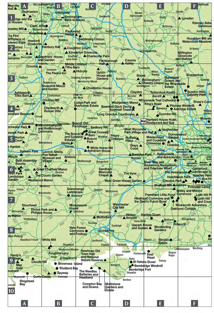
110


111 Clacton-on-Sea Birling Gap and the Seven Sisters The Cotswolds, Buckinghamshire and Oxfordshire page 30 Berkshire, Hampshire and the Isle of Wight page 38 Kent, Surrey and Sussex page 42 London page 52.& Buildings and gardens Coast and countryside o-- """"10 11 """"' - =i20 miles kilometres

112


113 East of England page 55 East Midlands page 64..t. Buildings and gardens Coast and countryside miles kilometres Hunstanton A149 use Orford Ness Natio al Nature Reserve
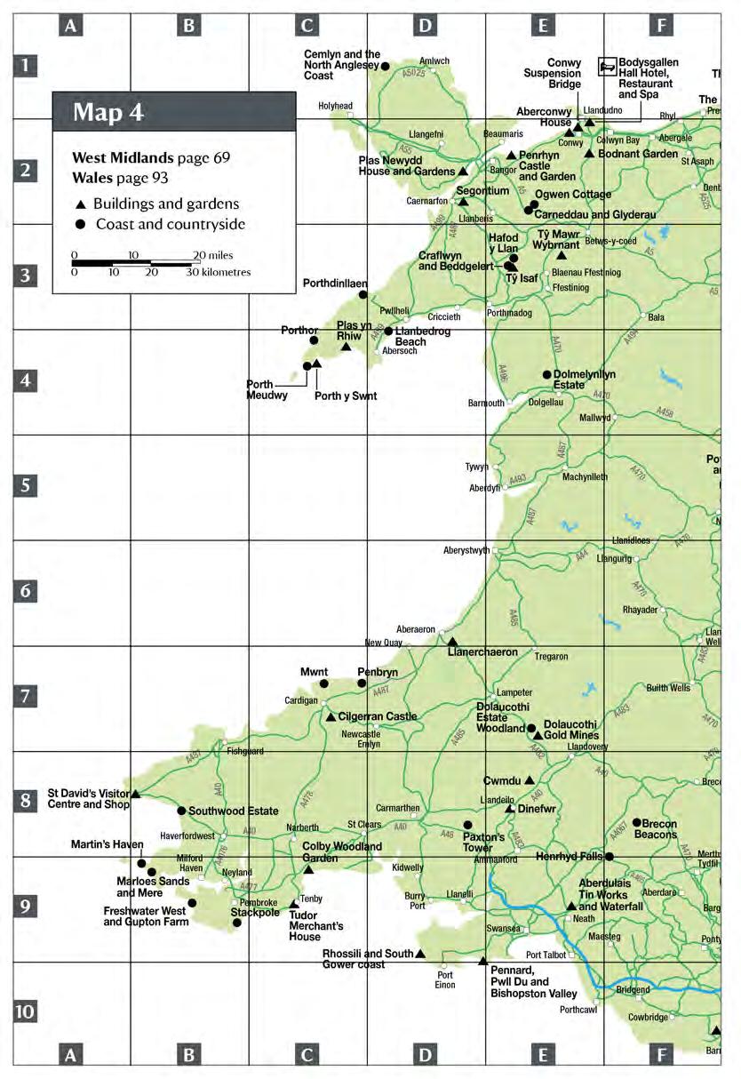
114

115

116


117 Id Hall ND ument North West page 76 The Lakes page 80 Yorkshire page 85 & Buildings and gardens Coast and countryside O miles o ii ll!10 2 o!"'" iiiiii ii!3i;:'o kilometres
![I [!] the National Trust for Scotland a place for everyone Members of the National Trust are also admitted free of charge to properties of the National Trust for Scotland (NTS), a separate charity](/docs-images/95/124145979/images/118-1.jpg "with similar responsibilities. NTS properties include a famous lnverewe Garden, Bannockburn, Culloden and Robert Adam's masterpiece, Culzean Castle.")
118 I [!] the National Trust for Scotland a place for everyone Members of the National Trust are also admitted free of charge to properties of the National Trust for Scotland (NTS), a separate charity with similar responsibilities. NTS properties include a famous lnverewe Garden, Bannockburn, Culloden and Robert Adam's masterpiece, Culzean Castle. Full details are contained in The National Trust for Scotland Guide to Properties, which can be obtained by contacting NTS Customer Service Centre, telephone Information is also available on the Internet at


119 North West page 76 The Lakes page 80 North East page 90.t. Buildings and gardens Coast and countryside miles kilometres er arfedale

120 I Northern Ireland page 103 Buildings and gardens Coast and countryside miles kilometres Carrick-a-Rede White Park Bay I Giant's Causeway I Portrush A Rathfin Island rnes I
TRUST LOCATIONS CORNWALL PARTNERSHIP NHS FOUNDATION TRUST
 TRUST LOCATIONS CORNWALL PARTNERSHIP NHS FOUNDATION TRUST Bodmin, Camborne, Falmouth, Helston, Launceston, Liskeard, Newquay, Penzance, Redruth, Royal Cornwall Hospital (Truro), St Austell, Truro DEVON
CONTENTS. Essential Information 90 Orientation 90 Exploring Bournemouth 90 Gastronomic Highlights 93 Transport 93
 Lonely Planet Publications Pty Ltd LONELYPLANET.COM CONTENTS 25 CONTENTS INTRODUCING DEVON, CORNWALL & SOUTHWEST ENGLAND GETTING STARTED 8 FESTIVALS & EVENTS 1 CULTURE 12 FOOD & DRINK 16 OUTDOORS 2 FAMILY
Tickets for your day out by bus. from April 2013
 Tickets for your day out by bus from April 2013 Just the ticket for your day out by bus Are you looking for a great day out with the kids, a hassle free shopping trip or to enjoy the scenery from the top
Cornwall booking form... 10% The Official Tourism Guide for Cornwall PRICES HELD. Book by Friday 16 May and save
 Cornwall The Official Tourism Guide for Cornwall 2015 booking form... 2015 PRICES HELD Book by Friday 16 May and save 10% Cornwall Guide Advertising Rates ALL advertisers MUST tick the box to indicate
Travelling to Exeter. Bus, Train or Park & Ride. Travel Information
 Travelling to Exeter Bus, Train or Park & Ride Travel Information Getting around bybus The map below shows the main bus routes into Exeter.Less frequent services from other areas also operate -for full
cornwall rural community council : community-led planning database
 cornwall rural community council : community-led planning database DeliveryArea: Central Community Network Area: China Clay Roche Roche Parish Jul 2003 Dec 2006 St Dennis St Dennis Parish 2009 March 2008
Poldark Trail in Cornwall
 http://www.intocornwall.com/features/poldark-trail.asp Poldark Trail in Cornwall A drive around all the Poldark filming locations in Cornwall Welcome to the Poldark Trail. A self guided tour to visit all
CTT - Open Events 2018 Paperwork record
 CTT - Open Events 2018 Paperwork record 28 January Sunday (transferred from 2017 canceled for safety reasons) 10 S3/10S 9.00 09:00 IE City Cycle Couriers RT PNF DUE 17/12 Arr 20/12 St Res Robert Scott,
Core NHS Health Check Providers
 Bournemouth Central Boots Pharmacy 18-20 Commercial Bournemouth Dorset BH2 5NL 01202 551713 Boots UK Ltd Boots Pharmacy Units E&F Castle Lane West Bournemouth Dorset BH8 9UB 01202 548139 Boots UK Ltd Bournemouth
Website:
 English Tourism Council Appointed TOURING & CAMPING PARK Website: www.carlyonbay.net E-mail: holidays@carlyonbay.net Welcome to Carlyon Bay Welcome to the award-winning Carlyon Bay Caravan & Camping Park,
LWC DRINKS CORNWALL CRICKET LEAGUE DIVISIONS 2018 ELEVENTH & FINAL DRAFT JANUARY
 Season Dates (Premier Division 5) Saturdays 21 April to 8 Sept inclusive plus County Finals Divisions 2-6 on Sat 15 September Season Dates (Division 6) Saturdays 5 May to 25 Aug inclusive plus Div 6 County
OPEN CONSENTED RETAIL PARK INVESTMENT NEWQUAY ROAD RETAIL PARK TRURO ENTER >
 OPEN CONSENTED PARK NEWQUAY ROAD PARK TRURO ENTER > OPEN CONSENTED PARK NEWQUAY ROAD PARK, TRURO TR1 1XD Truro, the dominant commercial administrative centre for Cornwall, is situated in a highly accessible
Walks from the Railway
 Devon and Cornwall Walks from the Railway Supported by Introduction The railways of Devon and Cornwall offer some of the most scenic train journeys in Britain. From stunning coastal views to rolling green
Historic churches in Cornwall Devon Dorset. uncover the. stories of the past. visitchurches.org.uk/daysout
 Historic churches in Cornwall uncover the stories of the past visitchurches.org.uk/daysout 4 bringing the past alive Explore the historic churches of, and Cornwall and discover a window to the past one
25 February Saturday 13 S3/13S :00 IE Plymouth Corinthian CC Lynn Marris, 24 Lowertown Close, Landrake, Saltash. PL12 5DG Tel:
 CTT - Open Events 19 February Sunday 10 S4/10 9.00 09:00 IE City Cycle Couriers RT 25 February Saturday 13 S3/13S 9.00 14:00 IE Plymouth Corinthian CC Lynn Marris, 24 Lowertown Close, Landrake, Saltash.
Index. 000 Map pages 000 Photograph pages. Lonely Planet 306
 Lonely Planet 306 Index A abbeys Bath 93 Buckland 206 Cerne Benedictine abbey 150 Forde Abbey 163 Glastonbury 107 Hartland Abbey 217 Muchelney 111 St Michael s Mount 248, 5 Shaftesbury 152-3 Sherbourne
Supporting Carers. Memory Café Information DEVON. Produced by David Light
 Supporting Carers Memory Café Information DEVON Produced by David Light 1 09 May 2017 No. MEMORY CAFÉ 1 ASHBURTON, BUCKFASTLEIGH & DART VALLEY 2 AXMINSTER 3 BARNSTAPLE 4 BARNSTAPLE (Pilton house) 5 BISHOPSTEIGNTON
Cornwall and West Devon Mining
 Cornish mining World Heritage Site Cornwall and West Devon Mining Landscape World Heritage Site, popularly known as Cornish Mining, has gained international recognition from UNESCO for specific mine sites,
! Supporting Carers. Memory Café Information DEVON
 ! Supporting Carers Memory Café Information DEVON 1! 25 August 2016 !! Produced by David Light No. MEMORY CAFÉ 1 ASHBURTON, BUCKFASTLEIGH & DART VALLEY 2 AXMINSTER 3 BARNSTAPLE 4 BARNSTAPLE (Pilton house)
Pengegon LANTEGLOS-BY-FOWEY SOUTH CORNWALL
 Pengegon LANTEGLOS-BY-FOWEY SOUTH CORNWALL Pengegon LANTEGLOS-BY-FOWEY SOUTH CORNWALL Occupying a fabulous waterside setting on the banks of Pont Pill, Pengegon represents an extraordinarily rare opportunity
St. Austell travel to work profile
 St. Austell travel to work profile Cornwall Settlement Travel to Work Profiles 2015 1 CONTENTS Contents Introduction 1 Key findings 2 Key flows from St Austell Map 1 Main flows out - locations Chart 1
Discover Devon. A great family site with beautiful views across the countryside and coast and so much to do in the local area. Hillhead Club Site
 Discover Devon A great family site with beautiful views across the countryside and coast and so much to do in the local area. Hillhead Club Site Make the most of your time... 04 Buckfastleigh Shipley Bridge
 About us Upton Coaches is a family business owned by the Thomas Family. We have been providing coaches for hire for many years and this year we are celebrating 30 years. Based on the Devon and Somerset
Rally Stewards: Jason & Stacy Avery Tel: ; MOB: ; PROGRAMME
 Rally No: 3878 Date: 9th June 12th June 2016 LADIES CHARITYRALLY (100 VANS) POLSON RUGBY CLUB, POLSON, LAUNCESTON. PL15 9QT By kind permission of: The Committee of Launceston Rugby Club Site Available:
SIDMOUTH & OTTERY HOCKEY CLUB
 SIDMOUTH & OTTERY HOCKEY CLUB REPAYMENT FOR DRIVING POLICY Aim This policy sets out the arrangements for making payment to reimburse drivers that transport payers to away matches. Introduction The Club
Discovery Trail. outstanding natural beauty.
 Discovery Trail Discover the Tamar Valley Area of Outstanding Natural Beauty along this 30-mile walking route. Waymarkers guide you through scenic woodland, historic river quays and rural villages. outstanding
RIVIERA LINE E X E T E R PAIGNTON
 RIVIERA LINE EXETER PAIGNTON Supported by Introduction The Riviera Line offers great scenic train journeys along the South Devon coast between Exeter and Paignton. The train is an ideal way to enjoy a
Ferla Meadow. The neighbouring parishes of Lanteglos and Advent are also home to picturesque churches which date back to the 12th Century.
 Trebarwith Strand Beach, just 5 miles from Ferla meadow Ferla Meadow Ferla Meadow will provide a total of nineteen stylish two and three bedroom bungalows and houses for sale within the old market town
Holywell Road Cubert. A high quality development of 2, 3 and 4 bedroomed homes situated in the picturesque Cornish village of Cubert.
 Parc an Rose Holywell Road Cubert A high quality development of 2, 3 and 4 bedroomed homes situated in the picturesque Cornish village of Cubert Holywell Bay Around Cubert Situated on the edge of the delightful
7 DAY ITINERARY IDEAS FOR A WEEK SPENT IN SOUTH CORNWALL
 7 DAY ITINERARY IDEAS FOR A WEEK SPENT IN SOUTH CORNWALL 1 HARBOURS AND HORTICULTURE DAY 1 Begin your day leisurely with breakfast in the pretty little village of Mevagissey. Enjoy a stroll around the
Scotland & The North East to The South West & South Coast
 Scotland & The North East to The South West & South Coast Train Times: 11 December 2011 13 May 2012 Get your journey information on the go with our new mobile app. Aberdeen Stonehaven Inverkeithing Glasgow
River Dart Country Park
 River Dart Country Park Camping and Touring excellence on Dartmoor 2008 The great outdoors at its best Hello & Welcome The River Dart Country Park and Holne Park House lie within the Dartmoor National
HEART SUPPORT GROUPS South West
 Cheltenham Gloucester HEART SUPPORT GROUPS South West Minehead Bristol Swindon Taunton Yeovil Poole Exeter Launceston Newquay Plymouth Penzance Channel Islands HEART SUPPORT GROUPS What are they? We are
2018 Dawlish Warren, South Devon
 HOLIDAY PARK Relaxing & Tranquil Holidays 2018 Dawlish Warren, South Devon Welcome & Unwind Welcome to Oakcliff Holiday Park, the perfect place for a holiday packed with peace and quiet, rest and relaxation.
Index of Multiple Deprivation 2007 Briefing Paper
 Introduction Index of Multiple Deprivation Briefing Paper Cornwall Children and Young People s Partnership, 20th December The Department of Communities and Local Government commissioned the Social Disadvantage
WELCOME TO NEWTON ABBOT RACECOURSE. Accessibility Statement February 2018
 WELCOME TO NEWTON ABBOT RACECOURSE Accessibility Statement February 2018 This access statement does not contain personal opinions as to our suitability for those with disabilities but aims to accurately
Transport Infrastructure Plan: Delivering Growth to 2030 November Transport Infrastructure Plan Delivering Growth to November 2014 DRAFT
 Transport Infrastructure Plan Delivering Growth to 2030 November 2014 DRAFT 1 Contents Introduction 3 Background 3 Policy Context 4 Devon Heart of the South West LEP Strategic Connectivity 5 A30/A303 Exeter
Population change in Cornwall
 Population change in Cornwall 1901-1951 1901-1911 In the Edwardian period population continued to rise, and at the fastest rate seen since the heyday of the mining industry in the 1850s. Growth was fuelled
THE BOATHOUSE. Beacon Road Kingswear Devon TQ6 0BS
 THE BOATHOUSE Beacon Road Kingswear Devon TQ6 0BS THE BOATHOUSE Beacon Road Kingswear Devon One of the most iconic waterfront houses in Kingswear Dartmouth across the River Dart and serviced by three
Promoting Car-Free Days out through a Rail Partnership
 Promoting Car-Free Days out through a Rail Partnership Category: Workshop In case of a workshop: Tourist/Leisure/Shopping sector Name: Organisation: Country: E-mail address: Richard Burningham Devon &
Introduction. Walking. St Keyne Wishing Well Halt Station to Causeland Pages 16 & 17. Gunnislake Station to Calstock Pages 18 & 19
 Introduction The branch lines of Cornwall offer some of the most scenic train journeys in Britain. From stunning coastal views along the St Ives Bay Line to the beauty of the Looe Valley and the spectacular
2017 Dawlish Warren, South Devon
 HOLIDAY PARK Relaxing & Tranquil Holidays 2017 Dawlish Warren, South Devon Welcome & Unwind Welcome to Oakcliff Holiday Park, the perfect place for a holiday packed with peace and quiet, rest and relaxation.
SW Coast Path North Cornwall Adventure Atlas1:25K A-Z (A-Z Adventure Atlas) By Geographers' A-Z Map Company
 By Geographers' A-Z Map Company") SW Coast Path North Cornwall Adventure Atlas1:25K A-Z (A-Z Adventure Atlas) By Geographers' A-Z Map Company If you are looking for a book by Geographers' A-Z Map Company SW Coast Path North Cornwall Adventure
SW Coast Path North Cornwall Adventure Atlas1:25K A-Z (A-Z Adventure Atlas) By Geographers' A-Z Map Company If you are looking for a book by Geographers' A-Z Map Company SW Coast Path North Cornwall Adventure
National League 3 South West
 National League 3 South West Bournemouth Bracknell Brixham Bromsgrove (subject to appeal) Camborne Cleve Dings Crusaders Hornets Ivybridge Launceston Lydney Newton Abbot Old Redcliffians Salisbury South
Final recommendations on the future electoral arrangements for Cornwall County Council. Report to The Electoral Commission
 Final recommendations on the future electoral arrangements for Cornwall County Council Report to The Electoral Commission September 2004 Translations and other formats For information on obtaining this
Armillary House 22 ESPLANADE FOWEY CORNWALL
 Armillary House 22 ESPLANADE FOWEY CORNWALL Armillary House 22 ESPLANADE FOWEY CORNWALL A charming family home, perfect either as a second home or as a main family residence that occupies a prime position
Key Information. Self-Guided Walk Corfe Castle to Swanage
 Self-Guided Walk Corfe Castle to Swanage A classic walk from the pretty village of Corfe Castle. Enjoy extensive views whilst walking along the wide ridge to the popular seaside town of Swanage, returning
April. Sun 30 White Rose Trial Atherley BC SO15 5DB am. May. Thur 4 Women v Surrey (A) Milford BC GU8 5HD pm
 Milford BC GU8 5HD pm") April Sun 30 White Rose Trial 1 Bank Holiday May Thur 4 Women v Surrey (A) Milford BC GU8 5HD - 1.30pm Sat 6 Women s Johns Trophy Trial Men v Royal County of Berkshire (A) Bracknell BC RG12 1EH - 2.00pm
April Sun 30 White Rose Trial 1 Bank Holiday May Thur 4 Women v Surrey (A) Milford BC GU8 5HD - 1.30pm Sat 6 Women s Johns Trophy Trial Men v Royal County of Berkshire (A) Bracknell BC RG12 1EH - 2.00pm
DEVON AND CORNWALL. Promoting Britain's Railway for Passengers and Freight. Newsletter December 2016 THIS ISSUE
 DEVON AND CORNWALL Newsletter December 2016 THIS ISSUE Exeter Bus Station Proposal Network Rail s Plan for Dawlish to Teignmouth Station Access Stakeholder Meetings A Look at the Sidmouth Line 2017 Meetings
MORTONS HOUSE HOTEL 45 East street, CorfE CastlE, BH20 5EE
 MORTONS HOUSE HOTEL 45 East Street, Corfe Castle, BH20 5EE MORTONS HOUSE HOTEL 45 East Street, Corfe, BH20 5EE Swanage 5.1 miles, Wareham 5.7 miles, Poole 14.5 miles, Dorchester 20.9 miles (all distances
Fixtures and Results. South West Premier 03/03/2018. Wadworth 6X South West 1 East 03/03/2018. Tribute South West 1 West 03/03/2018
 South West Premier Bournemouth P - P Ivybridge Bracknell P - P Lydney Brixham P - P Maidenhead Camborne P - P Dings Crusaders Newbury Blues P - P Cleve Newton Abbot P - P Hornets Weston-super-Mare P -
Self-Guided Walk Botallack to Land s End
 Self-Guided Walk Botallack to Land s End A beautiful coastal walk rich in industrial heritage, wildlife and swimming opportunities too. Ending at Land's End. Michael Carpenter, route researcher Key Information
West Lynch House ALLERFORD, PORLOCK, SOMERSET
 West Lynch House ALLERFORD, PORLOCK, SOMERSET West Lynch House ALLERFORD, PORLOCK, SOMERSET Porlock 1 mile Taunton 28 miles (London Paddington 1 hour 45 minutes) Minehead 5 miles Exeter 43.5 miles (All
Cornwall. Local Plan. Strategic Policies Community Network Area Sections. Planning for Cornwall s future
 Cornwall Planning for Cornwall s future Local Plan Strategic Policies 2010-2030 Community Network Area Sections www.cornwall.gov.uk Dalghow Contents 3 Community Networks 6 12 18 22 28 32 36 38 41 51 54
THE GREAT PRESENTS CORNISH RAIL ALE TRAIL. 20 great St Austell Brewery pubs you can reach by rail, handpicked by our Head Brewer, Roger Ryman
 PRESENTS FREE T-SHIRT TO BE CLAIMED See inside for details THE GREAT CORNISH RAIL ALE TRAIL GET ON THE RAIL ALE TRAIL! 20 great Brewery pubs you can reach by rail, handpicked by our Head Brewer, Roger
DEVON AND CORNWALL. Promoting Britain's Railway for Passengers and Freight. Newsletter November 2017 THIS ISSUE
 DEVON AND CORNWALL Newsletter November 2017 THIS ISSUE Railfuture s Salisbury to Exeter Report Discussion Okehampton Parkway: background & discussion A Look at the Bude Branch Next Meetings Planned Footpath
The Magic of Cornwall
 The Magic of Cornwall This tailor-made programme offers an in-depth tour of England s south-westerly county Dream Escape provides the creativity and insider access to show you the secret villages and hidden
Size: x 12 Twelve leaves plus covers. Individually wrapped. Mailing wallet supplied. Wire-o-bound
 WEST COUNTRY POSTER ART Published in association with the National Railway Museum, this calendar contains twelve colourful vintage poster art prints. These striking posters were produced to promote rail
Camping and Touring excellence on Dartmoor
 Camping and Touring excellence on Dartmoor 2014 Welcome The River Dart Country Park and Holne Park House lie within the Dartmoor National Park, an area of outstanding natural beauty. The River Dart Country
Devon & Cornwall Police
 Devon & Cornwall Police Record 1 Freedom of Information Act Request No: 7382/12 1) Number of road traffic fatalities in Devon and Cornwall from 2007 to 2012 inclusive. 2) The location of each of these
Mr Andrew Haines Managing Director First Group Rail Division 3rd Floor, E Block Paddington Station London W2 1FG
 Mr Andrew Haines (Andrew.Haines@Firstgroup.com) Managing Director First Group Rail Division 3rd Floor, E Block Paddington Station London W2 1FG Whittles House, 14 Pentonville Road London N1 9HF w www.passengerfocus.org.uk
Rosamund Osbourn at Arlington Court
 Enabling easy access to the South West s outdoor attractions and beauty spots Project Update 13: Autum 2013 Summer is now a distant memory but what a great year it's been! With the south west experiencing
WR Reporting Numbers Summer Compiled by Ed Chaplin
 WR Reporting Numbers Summer 1957 Compiled by Ed Chaplin This list is my best shot to date. I do not claim it is 100% correct or complete, but much time has been spent on getting to this stage. I want to
River Dart Country Park
 River Dart Country Park Camping and Touring excellence on Dartmoor 2009 The great outdoors at its best Hello & Welcome River Dart Country Park and Holne Park House lie within Dartmoor National Park, an
Study. in the South West. STUDY IN THE SOUTH WEST FAM TRIP March Jurassic Coast, Dorset. at
 in the South West Jurassic Coast, Dorset STUDY IN THE SOUTH WEST FAM TRIP 13-19 March 2016 at www.swengland.com in the South West GLOUCESTERSHIRE Port of Bristol BRISTOL WILTSHIRE Lundy Bristol Airport
NFU South West Calendar 2016 Region/ Group
 Sherborne Mid Show Brexit Woolsery and District Agricultural Show Women in Dairy and Women in Dairy and Women in Dairy and Women in Dairy and For more information : http://www.middevonshow.co.uk/ The Sherborne
Our new Great Western Franchise. Tarka Rail Association AGM June 2015
 Our new Great Western Franchise Tarka Rail Association AGM June 2015 To cover New Franchise - recap Implications for the line Taking forward the strategy 3 Second Great Western Direct Award Overview Brand
Finding your way. Site and parking information
 Finding your way. Site and parking information Getting to Southampton By car Southampton is just 75 miles (120km) from London. The M3, M27 and A34 provide fast, direct access while the A36 is the main
Canonteign Barton CANONTEIGN TEIGN VALLEY Devon
 Canonteign Barton CANONTEIGN TEIGN VALLEY Devon Canonteign Barton CANONTEIGN TEIGN VALLEY Devon Exeter 10 miles (London Paddington 2 hours) Bovey Tracey 4 miles A38 dual carriageway 4 miles (Distances
... OAKDOWN TOURING PARK, GATEDOWN LANE, SIDMOUTH. EX10 0PT (SAT NAV USE P/CODE: EX10 0PD)
") Rally No: 3865 Date: 8th April - 10th April 2016 FAMILY FUN WEEKEND RALLY (30 VANS) BROADLEIGH FARM, STOKE GABRIEL, PAIGNTON, DEVON By kind permission of: Roger & Christine Hunt Directions: From either
Rally No: 3865 Date: 8th April - 10th April 2016 FAMILY FUN WEEKEND RALLY (30 VANS) BROADLEIGH FARM, STOKE GABRIEL, PAIGNTON, DEVON By kind permission of: Roger & Christine Hunt Directions: From either
White Hart Cottage, Menheniot, Nr Liskeard, Cornwall, PL14 3QZ
 White Hart Cottage Menheniot Near Liskeard Cornwall PL14 3QZ Dear Guest, I have put together this information pack in order to help you find places to visit. All the places named are local with the odd
Trials for Entries on field. Refreshments Tea and cakes available. Refreshments
 Trials for 2016 Sunday May 8th Cheselbourne Sheepdog Trial By kind permission of Mr T Besent (In Aid of Somerset & Dorset Air Ambulance) At Manor Farm, Cheselbourne, Dorset DT2 7NR Classes: Novice/Open
Treworgie Barton Cottages ST GENNYS BUDE EX23 0NL
 Treworgie Barton Cottages ST GENNYS BUDE EX23 0NL VIEW FROM TOP FIELD Treworgie Barton Cottages ST GENNYS, BUDE, EX23 0NL Bude 9.0 miles, Barnstaple 41.9 miles, Exeter 59.0 miles (all distances are approximate)
LEARN MORE TODAY BECOME A DORSET AMBASSADOR
 LEARN MORE TODAY BECOME A DORSET AMBASSADOR Promoting Dorset Dorset has a stunning coastline, attractive rural landscapes, lively seaside resorts, fascinating towns and villages all reasons for tourists
The Croft LOWER ASHTON, EXETER, DEVON
 The Croft LOWER ASHTON, EXETER, DEVON The Croft LOWER ASHTON, EXETER, DEVON Chudleigh 5 miles Exeter 8 miles (London Paddington 2 hours) Moretonhampstead 8 miles Bovey Tracey 7 miles (All distances and
Scotland, The North East & Manchester to The South West & South Coast
 Scotland, The North East & Manchester to The South West & South Coast Sunday 20 May Saturday 8 December 2018 Live train times online and on our Train Tickets app. Aberdeen Stonehaven Inverkeithing Glasgow
Plymouth C-Card, Chlamydia Screening and Emergency Hormonal Contraception Scheme Sites
 Plymouth C-Card, Chlamydia Screening and Emergency Hormonal Contraception Scheme Sites This is a list of all current C-Card sites. This list is for service providers only as it is always changing and we
Devon Environmental Business Initiative
 2011 Devon Environmental Business Initiative Book online: www.riverdart.co.uk Bookings: 01364 652511 Welcome The River Dart Country Park and Holne Park House lie within the Dartmoor National Park, an area
Scotland, The North East & Manchester to The South West & South Coast
 Scotland, The North East & Manchester to The South West & South Coast Sunday 9 December 2018 Saturday 18 May 2019 Live train times online and on our Train Tickets app. Aberdeen Stonehaven Inverkeithing
A30 Chiverton to Carland Cross Statement of Community Consultation
 A30 Chiverton to Carland Cross Statement of Community Consultation Table of contents 1 Introduction... 3 2 The application... 4 3 The scheme... 5 4 Early stages of consultation... 7 5 Statutory consultation...
WEST COUNTRY. Our website. All the B&Bs can be found on our website:
 west country 2017 17/5/70 2:16 am Page 17 WEST COUNTRY. TRELEW FARM is a traditional 17th century farmhouse on a working dairy farm. There is a nature trail on the farm land which leads to an ancient stone
WEST COUNTRY. Pricing
 west country 2018 18/12/10 3:54 am Page 15 WEST COUNTRY. TRELEW FARM is a traditional 17th century farmhouse on a working dairy farm. There is a nature trail on the farm land which leads to an ancient
Steep House, Lower Steep House & Old Portmellon Cottage. Portmellon Nr Mevagissey South Cornwall
 Steep House, Lower Steep House & Old Portmellon Cottage Portmellon Nr Mevagissey South Cornwall Steep House, Lower Steep House & Old Portmellon Cottage Portmellon Nr Mevagissey South Cornwall An outstanding
Contents. Introduction. Chapter 1 Plymouth to Saltash 1. Chapter 2 Royal Albert Bridge (RAB) to Liskeard 9. Chapter 3 Liskeard to Bodmin Road 22
 to Liskeard 9. Chapter 3 Liskeard to Bodmin Road 22") Contents Introduction vii Chapter 1 Plymouth to Saltash 1 Chapter 2 Royal Albert Bridge (RAB) to Liskeard 9 Chapter 3 Liskeard to Bodmin Road 22 Chapter 4 Bodmin Road to Par 33 Chapter 5 Par to Truro 43
Contents Introduction vii Chapter 1 Plymouth to Saltash 1 Chapter 2 Royal Albert Bridge (RAB) to Liskeard 9 Chapter 3 Liskeard to Bodmin Road 22 Chapter 4 Bodmin Road to Par 33 Chapter 5 Par to Truro 43
Polsue Farm The Roseland
 Polsue Farm The Roseland Polsue Farm TREGONY THE ROSELAND CORNWALL TR2 5SW Modern country house set in 8.5 acres of private grounds with detached outbuildings and glorious views just two miles from the
Business Park CORNWALL AIRPORT NEWQUAY
 Business Park CORNWALL AIRPORT NEWQUAY Business Park Welcome to the Aerohub Business Park, one of the UK s largest designated Enterprise Zones, providing planning-free development plots, rates relief and
Spring Blossoms in the Duchy of Cornwall and the Isles of Scilly
 Spring Blossoms in the Duchy of Cornwall and the Isles of Scilly A highpoint of this tour is our visit to the gardens of Highgrove House, home of HRH the Prince of Wales Monday 9 th April Leave United
Hengar Manor Country Park ST TUDY, BODMIN, CORNWALL, PL30 3PL
 Hengar Manor Country Park ; Currently developed with 161 holiday units; 96 of which are privately owned and 65 are company owned. ; Central Cornwall location providing an excellent base for exploring this
HIGHLANDS, BUTTLEGATE, DOWNDERRY, TORPOINT, CORNWALL PL11 3NQ GUIDE PRICE 550,000
 HIGHLANDS, BUTTLEGATE, DOWNDERRY, TORPOINT, CORNWALL PL11 3NQ GUIDE PRICE 550,000 BEACH 250 YARDS, LOOE 5 MILES, PLYMOUTH 18 MILES, FOWEY 19 MILES, NEW QUAY AIRPORT 37 MILES Only 250 yards from the beach,
Appendix E CIL Affordability Calculation
 Appendix E CIL Affordability Calculation Cornwall CIL Contribution Viability Calculation Community Network including subdivision to main towns Pre-submission draft target published CC approved and published
Mondays to Fridays 595 Sch
 Wadebridge - Polzeath - Port Isaac - Camelford Timetable valid from /0/0 until /0/0. Direction of stops: where shown (eg: W-bound) this is the compass direction towards which the bus is pointing when it
List of Ordnance Survey authorised wholesalers
 List of Ordnance Survey authorised wholesalers July Ordnance Survey authorised wholesalers stock large quantities of Ordnance Survey maps of their local area. Additionally some wholesalers carry the complete
WALK 2 POOLE HARBOUR. Greenlands To Norden Park-and-ride. Trails
 POOLE Trails WALK 2 Greenlands To Norden Park-and-ride Local History Geology This route is dominated by the chalk ridge which runs from Old Harry at Studland to beyond West Lulworth. The ridge once continued
Meridyth Plaidy, Looe, Cornwall
 Meridyth Plaidy, Looe, Cornwall An inspiring and totally individual contemporary coastal home with a superb specification and sea view. Guide Price 1,200,000 Features Multi-Level Accommodation Striking
The Gallery & Royal Clarence Hotel, Exeter, Fire On the fire ground All Photographs by Eric Chapman
 CHESHIRE - TVAC Hilton?? ORDER FOR TWO PAGE 37 OF Fire Cover 197 cancelled See http://www.cheshirefire.gov.uk/assets/fire%20authority/ item13carpupdate15-04-09.pdf and http://www.cheshirefire.gov.uk/assets/fire%20authority/06combinedaerialrescuep
 www.beeches-park.co.uk Discover the best... Beeches Holiday Park The Beeches is the perfect location to realise your dream a peaceful holiday retreat of your very own on the beautiful Somerset coast, with
ACTIVITY & ACHIEVEMENT FOR DORSET
 ACTIVITY & ACHIEVEMENT FOR DORSET Dorset Local Enterprise Partnership (LEP) is a business-led private and public sector partnership that aims to promote local economic growth and prosperity. Acting as
Barn Lane Farm. Stoke Rivers, Barnstaple, North Devon, EX32 7LD
 Barn Lane Farm Stoke Rivers, Barnstaple, North Devon, EX32 7LD Barn lane Farm Stoke Rivers, Barnstaple, North Devon, EX32 7LD Modern 5 bedroom farmhouse Useful range of farm buildings and stables 55 acres
Moorland View Princetown, Devon. 4.6 acres stand of high quality, mature conifer with good access for 28,000 (freehold)
") WOODS 4 SALE Phone: 01248 364 362 www.woods4sale.co.uk UK Woodland & Woods For Sale: Specialising in the Sales of Small Woodlands in England, Scotland and Wales for Recreation, Wildlife Conservation and
WOODS 4 SALE Phone: 01248 364 362 www.woods4sale.co.uk UK Woodland & Woods For Sale: Specialising in the Sales of Small Woodlands in England, Scotland and Wales for Recreation, Wildlife Conservation and
WALK 3 POOLE HARBOUR. Norden Park-and-Ride To Wareham. Trails
 POOLE Trails WALK 3 Norden Park-and-Ride To Wareham Local History Geology The heathland here is agriculturally poor but the riches of ball clay and oil lie beneath. There are oil-rich seams in a continuous