ATTACHMENT 1. Site Location Maps
|
|
|
- Miles Morris
- 5 years ago
- Views:
Transcription


1 ATTACHMENT 1 Site Location Maps


2 G:\GIS\Projects\CSX_National\ArcMap\PA_Team_2\PLE_10_25_Topo.mxd - 10:44:21 AM OVERHEAD WALKWAY PLE OVERHEAD WALKWAY CORAOPOLIS, REPLACE EXISTING BRIDGE QUADRANGLE NAME - AMBRIDGE PLE 10.25


3 G:\GIS\Projects\CSX_National\ArcMap\PA_Team_2\PLE_3_79_Topo.mxd - 10:43:19 AM OHIO CENTRAL RAILROAD PLE 3.79 OHIO CENTRAL RAILROAD MCKEES ROCKS, LOWER TRACKS QUADRANGLE NAME - PITTSBURGH WEST PLE 3.79


4 G:\GIS\Projects\CSX_National\ArcMap\PA_Team_2\PLE_3_36_Topomxd.mxd - 10:42:14 AM CHARTIERS CREEK PLE 3.36 CHARTIERS CREEK PITTSBURGH, EXISTING BRIDGE MODIFICATION QUADRANGLE NAME - PITTSBURGH WEST PLE 3.36


5 G:\GIS\Projects\CSX_National\ArcMap\PA_Team_2\PLY_0_09_Topo.mxd - 10:45:35 AM SMITHFIELD STREET PLY 0.09 SMITHFIELD STREET PITTSBURGH, LOWER TRACKS QUADRANGLE NAME - PITTSBURGH WEST PLY 0.09


6 G:\GIS\Projects\CSX_National\ArcMap\PA_Team_1\PLY_JL_Tunnel_Topo.mxd - 10:32:19 AM WEST END OF J&L TUNNEL PLY 1.96 J&L TUNNEL PLY 2.00 EAST END OF J&L TUNNEL PLY 2.37 PLY REMOVE EXISTING BRIDGE SUPERSTRUCTURE PLY RAISE/REPLACE TUNNEL ROOF SLAB PLY REMOVE PORTIONS OF EXISTING BRIDGE QUADRANGLE NAME - PITTSBURGH EAST J&L TUNNEL PITTSBURGH, PLY & 2.37

7 G:\GIS\Projects\CSX_National\ArcMap\PA_Team_2\_309_70_Topo.mxd - 10:41:08 AM WALNUT STREET WALNUT STREET, MCKEESPORT, LOWER TRACKS - UNDERCUT LOCATION QUADRANGLE NAME - MCKEESPORT


8 G:\GIS\Projects\CSX_National\ArcMap\PA_Team_1\J_5_00_Topo.mxd - 10:18:46 AM BENFORD TUNNEL J 5.00 QUADRANGLE NAME - CONFLUENCE BENFORD TUNNEL CONFLUENCE, OPEN-CUTTING OF TUNNEL J 5.00

9 CITY: DIV/GROUP:SER/AIT DB:L.GREENE LD: PIC: PM: TM: TR: Project (Project #)GA Friday, August 14, /14/2009 3:03:32 PM C:\Documents and Settings\LGreene\Desktop\temp\CSXT\National_Gateway\mapdoc\PA\MATERIAL_STORE_CONFLUENCE_PA_TOPO.mxd EXCESS MATERIAL PLACEMENT AREA EXCESS MATERIAL PLACEMENT AREA DATA SOURCES: TOPOGRAPHIC IMAGE - USGS QUADRANGLE NAME: CONFLUENCE EXCESS MATERIAL PLACEMENT AREA CONFLUENCE, J


10 G:\GIS\Projects\CSX_National\ArcMap\PA_Team_1\_239_70_Topo.mxd - 10:17:25 AM BROOK TUNNEL BROOK TUNNEL CONFLUENCE, TOTAL ARCH LINEAR REPLACEMENT QUADRANGLE NAME - CONFLUENCE


11 G:\GIS\Projects\CSX_National\ArcMap\PA_Team_1\_236_80_Topo.mxd - 10:15:53 AM SHOOFLY TUNNEL SHOOFLY TUNNEL CONFLUENCE, OPEN-CUTTING OF TUNNEL QUADRANGLE NAME - CONFLUENCE


12 G:\GIS\Projects\CSX_National\ArcMap\PA_Team_1\_235_40_Topo_rev1.mxd - 9:39:44 AM PINKERTON TUNNEL PINKERTON TUNNEL PINKERTON, TOTAL ARCH LINEAR REPLACEMENT QUADRANGLE NAME - MARKLETON

13 CITY: DIV/GROUP:SER/AIT DB:L.GREENE LD: PIC: PM: TM: TR: Project (Project #)GA Friday, August 14, /14/2009 3:00:35 PM C:\Documents and Settings\LGreene\Desktop\temp\CSXT\National_Gateway\mapdoc\PA\MATERIAL_STORE_BLACK_PA_topo.mxd EXCESS MATERIAL PLACEMENT AREA EXCESS MATERIAL PLACEMENT AREA DATA SOURCES: TOPOGRAPHIC IMAGE - USGS QUADRANGLE NAME: ROCKWOOD EXCESS MATERIAL PLACEMENT AREA BLACK,


14 G:\GIS\Projects\CSX_National\ArcMap\PA_Team_2\_220_00_Topo.mxd - 10:38:51 AM CHURCH STREET CHURCH STREET, GARRETT, REPLACE EXISTING BRIDGE QUADRANGLE NAME - MEYERSDALE


15 G:\GIS\Projects\CSX_National\ArcMap\PA_Team_2\_212_83_Topo.mxd - 10:37:15 AM BLUE LICK TRUSS BLUE LICK TRUSS, SAND PATCH, RAISE BRIDGE SUPERSTRUCTURE QUADRANGLE NAME - WITTENBERG


16 G:\GIS\Projects\CSX_National\ArcMap\PA_Team_1\_210_60_Topo.mxd - 10:10:20 AM SAND PATCH TUNNEL SAND PATCH TUNNEL SAND PATCH, LINEAR NOTCHING / PORTAL CAPS QUADRANGLE NAME - WITTENBERG
GA063877.0000.")


17 CITY: DIV/GROUP:SER/AIT DB:L.GREENE LD: PIC: PM: TM: TR: Project (Project #)GA Friday, August 14, /14/2009 3:06:06 PM C:\Documents and Settings\LGreene\Desktop\temp\CSXT\National_Gateway\mapdoc\PA\MATERIAL_STORE_SANDPATCH_PA_TOPO.mxd MATERIAL STORAGE AREA MATERIAL STORAGE AREA SAND PATCH, DATA SOURCES: TOPOGRAPHIC IMAGE - USGS QUADRANGLE NAME: WITTENBERG X


18 G:\GIS\Projects\CSX_National\ArcMap\PA_Team_1\_198_40_Topo.mxd - 10:08:07 AM FALLS CUT TUNNEL QUADRANGLE NAME - FAIRHOPE FALLS CUT TUNNEL FAIRHOPE, TOTAL ARCH LINEAR REPLACEMENT


19 G:\GIS\Projects\CSX_National\ArcMap\PA_Team_2\_191_92_Topo.mxd - 10:36:01 AM RAILROAD BRIDGE RAILROAD BRIDGE, HYNDMAN, EXISTING BRIDGE MODIFICATION QUADRANGLE NAME - HYNDMAN
GREAT ALLEGHENY PASSAGE TRIP PACKAGES by Bike the GAP exclusively for Golden Triangle Bike Rental 2014 SEASON. 7 DAY. PITTSBURGH TO DC Package
 GREAT ALLEGHENY PASSAGE TRIP PACKAGES by Bike the GAP exclusively for Golden Triangle Bike Rental 2014 SEASON 7 DAY. PITTSBURGH TO DC Package Cost. $1,299 per person, based on double occupancy. Includes
Trail Town Program Creating Opportunities along the Nation s Trails. David Kahley President & CEO The Progress Fund
 Trail Town Program Creating Opportunities along the Nation s Trails David Kahley President & CEO The Progress Fund The Progress Fund Non-Profit Established 1997 CDFI with Rural Focus Provides Capital &
State Level Historic Documentation Report. John Blue Bridge Hampshire County
 State Level Historic Documentation Report State Project No. S314-28-22.27 Federal Project No. BR-0028(058)D John Blue Bridge Hampshire County Prepared by: Randy Epperly, Historian Department of Transportation
The site is located on federal land managed by the USFS, and is subject to the San Bernardino National Forest Management Plan (SBNFMP).
.") County of Riverside Public Safety Enterprise Communication Project Appendix A: Candidate Site Descriptions Overview The site is located near an existing County communication tower and USFS lookout tower
County of Riverside Public Safety Enterprise Communication Project Appendix A: Candidate Site Descriptions Overview The site is located near an existing County communication tower and USFS lookout tower
PennDOT Announces 2016 Allegheny County Highway and Bridge Improvement Projects
 PennDOT Announces 2016 Allegheny County Highway and Bridge Improvement Projects Pittsburgh - PennDOT is pleased to announce the 2016 Allegheny County transportation improvement project list for state-owned
Dufferin Jog Elimination Project
 Project Project Status Update November 14 2007 Project History Planning Alternatives Criteria Measured Project Benefits Structural Configurations Considered Structural Design Considerations The Preferred
SPENCER, WEST VIRGINIA
 AVAILABLE SPACE ROANE HARDWOOD FACILITY LOCATION Building Address - 554 Spring Creek Road Spencer, WV 25276 Located in City Limits - No Zoning - County - Roane Located in Business/Industrial Park - No
BOOTH RULES AND REGULATIONS
 BOOTH RULES AND REGULATIONS Booth Approval: ALL booths, regardless of booth type, are required to submit their Booth Approval Form along with diagrams or pictures for approval by September 25, 2018. Access
APPENDIX G WATER QUALITY IMPACTS
 APPENDIX G WATER QUALITY IMPACTS Potential surface water quality impacts were compared between the alignment alternatives using a method developed by AHTD. A system was devised to calculate a stream crossing
LESAGE, WEST VIRGINIA
 AVAILABLE SPACE BRICK AND CLAY MACHINERY COMPANY BUILDING COMPANY BUILDING LOCATION Building Address - 47 Williams Street Lesage, WV 25537 Located in City Limits - No County - Cabell Located in Business/Industrial
Pennsylvania Public Utility Commission
 DECISIONS OF Pennsylvania Public Utility Commission VOLUME 33 HARRISBURG, PENNSYLVANIA 1958 TABLE OF CASES A Page Altoona-Pittsburgh Freight Line, Joseph R. Prostko t/d/b/a, Application of 66 _Ambridge
Valuation Section Operating Company / Division No. of Maps Map Label Main or Branch Line
 Valuation Section Operating Company / Division No. of Maps Map Label Main or Branch Line 001-NY-V001-001 NY Terminal 2 New York Terminals New York City 002-NY-V002-001 SIRT Railway 21 Staten Island Rapid
Table 1: Santiago Peak Communication Site. Latitude 1 Longitude 1 Elev 2 Address T/R/S 3 APN 4 USGS Quadrangle
 County of Riverside Public Safety Enterprise Communication Project Appendix A: Candidate Site Descriptions Overview The site is located in the Cleveland National Forest (CNF) at an existing communication
2014 Project Update. PennDOT District 2-0 Karen Michael
 2014 Project Update PennDOT District 2-0 Karen Michael District 2-0 entre County Over the last 5 Years completed: 17 Bridge Replacements 23 Bridge Preservations 8 Highway Projects 5 Enhancement Project
Use steel clip angle as a drill template and drill through mullion. Install bolts with bolt heads on the masonry side of the jamb mullion.
 Additional 200xpt and 250xpt installation instructions are shown on page 11. STICK METHOD ERECTION (refer to figures 1 and 2) Step 1 Establish all control lines and grades. Step 2 Attach steel intermediate
WEST PITTSBURGH POPULATION TREND ::: ,000 9,000 8,000 TOTAL POPULATION 7,000 6,000 5,000 4,000 3,000 2,000
 ELLIOTT A HOLISTIC STUDY of the physical and aesthetic DETAILS, CHARACTERISTICS, AND INTERVENTIONS Department of Landscape Architecture College of Arts and Architecture The Pennsylvania State University
Arch bridges were built by the Romans and have been in use ever since. They are often chosen for their strength and
 Arch Bridges Arch bridges were built by the Romans and have been in use ever since. They are often chosen for their strength and appearance. It is the shape of the arch that gives the bridge its strength,
MOOREFIELD, WEST VIRGINIA
 AVAILABLE SPACE AMERICAN WOODMARK MOOREFIELD PLANT LOCATION Building Address - 117 South Fork Road Moorefield, WV 26836 Located in City Limits - Yes County - Hardy Located in Business/Industrial Park -
ELIZABETH, WEST VIRGINIA
 AVAILABLE SPACE WIRT INDUSTRIAL CENTER LOCATION Building Address - Route 14 at Tucker Creek Road Elizabeth, WV 26143 Located in City Limits - No Zoning - County - Wirt Located in Business/Industrial Park
PIAA BOYS BASKETBALL CHAMPIONSHIP TEAM RECORDS ( )
") ALL GAMES (ALL CLASSES) 115: Juniata Valley, vs. Salisbury-Elk Lick (71) 1996 1A first round 113: Neumann-Goretti, vs. Scranton Prep (71) 2016 3A second round 110: George Jr. Republic, vs. Richland [6]
ALL GAMES (ALL CLASSES) 115: Juniata Valley, vs. Salisbury-Elk Lick (71) 1996 1A first round 113: Neumann-Goretti, vs. Scranton Prep (71) 2016 3A second round 110: George Jr. Republic, vs. Richland [6]
Section XIII. Cost Estimates
 Section XIII Cost Estimates 13-01. INTRODUCTION SECTION XIII COST ESTIMATES a. General. Preliminary cost estimates for development of proposed new and renovation or replacement actions at Lake Shelbyville
CLARKSBURG, WEST VIRGINIA
 AVAILABLE SPACE CLARKSBURG BUILDING UNITS 3 & 4 LOCATION Building Address - 761 Armory Road Clarksburg, WV 26301 Located in City Limits - No County - Harrison Located in Business/Industrial Park - No Can
Table 1: Iron Mountain Communication Site. Latitude 1 Longitude 1 Elev 2 Address T/R/S 3 APN 4 USGS Quadrangle
 County of Riverside Public Safety Enterprise Communication Project Appendix A: Candidate Site Descriptions Overview The site is located in San Bernardino County near several communication towers in the
Pennsylvania Turnpike Commission 03/30/ YEAR CAPITAL PLANNING PROCESS
 Pennsylvania Turnpike Commission 3/3/29 1 YEAR CAPITAL PLANNING PROCESS PRIORITIZED LISTING OF FINAL COPY FOR FISCAL YEAR 26-27 FOR ALL EXCEPT INDEPENDENTLY FUNDED PROGRAM, ALL TYPES, ALL PHASES (in $)
MEMORANDUM. Honorable Mayor and City Councilmembers William S. Joynes, Sr., City Administrator
 AGENDA ITEM 1A MEMORANDUM DATE: January 17, 2017 TO: FROM: SUBJECT: Honorable Mayor and City Councilmembers William S. Joynes, Sr., City Administrator Sue Polka, Interim Asst. Public Works Director/City
OWNER S MANUAL. ezup.com. 13 x 13 (4.0m x 4.0m) 10 x 10 (3.0m x 3.0m) 16 x 16 (5.0m x 5.0m)
 10 x 10 (3.0m x 3.0m) 16 x 16 (5.0m x 5.0m)") Shown: Aero Dome with optional awning, sidewall and custom graphics OWNER S MANUAL 10 x 10 (3.0m x 3.0m) 13 x 13 (4.0m x 4.0m) 16 x 16 (5.0m x 5.0m) ezup.com THANK YOU THANK YOU FOR PURCHASING YOUR AERO
Shown: Aero Dome with optional awning, sidewall and custom graphics OWNER S MANUAL 10 x 10 (3.0m x 3.0m) 13 x 13 (4.0m x 4.0m) 16 x 16 (5.0m x 5.0m) ezup.com THANK YOU THANK YOU FOR PURCHASING YOUR AERO
MP : Headwaters of the Fraser River
 MP 236 237: Headwaters of the Fraser River The mile between these two mileage posts is often just referred to as the bottom switchback or the curve at the bottom of Berthoud Pass. For many locals this
Whittier Bridge Project
 Amesbury / Newburyport / Salisbury Whittier Bridge / I-95 Improvement Project Original Whittier Bridge Proposed Whittier Bridges 10/21/2016 Whittier Bridge Project 1 Project Description The project limits
Homes in Yauhanna Landing Overview
 FLOOR PLAN BED/BATH Homes in Yauhanna Landing Overview Land and Homes Packages starting from $109,900 HEATED SQFT* PRICE** Includes Standard Home site THE AUGUSTUS 3 Bed 2 Bath 1223 $119,999 No Garage
DO NOT USE WITH CROSSBAR SPREAD LESS THAN 24.
 TM Please read all instructions carefully before assembly, installation and/or use of this product. DO NOT USE WITH CROSSBAR SPREAD LESS THAN 24. WARNING: Do not exceed the weight limit of your vehicle
WHEREAS, that the Township of Blairstown is agreeable to assuming the
 TOWNSHIP OF BLAIRSTOWN COUNTY OF WARREN STATE OF NEW JERSEY ORDINANCE NO. 2018-014 AN ORDINANCE APPROVING THE EXCHANGE OF OWNERSHIP OF ROADWAYS AND CULVERTS LOCATED IN BLAIRSTOWN TOWNSHIP WITH THE COUNTY
AVAILABLE SPACE COLD STORAGE BUILDING NO. 2
 AVAILABLE SPACE COLD STORAGE BUILDING NO. 2 LOCATION Building Address - Cold Storage Road Located in City Limits - Yes County - Jefferson Located in Business/Industrial Park - No Can the Building be Multi-Tenant
Road Scholar Gopher Science Olympiad Invitational January 6, Team #: Team Name: Names: Score:
 Road Scholar Gopher Science Olympiad Invitational January 6, 2018 Team #: Team Name: Names: Score: Welcome to Road Scholar! Your Science Olympiad team is planning a trip to an invitational tournament in
2 an uncommon Passage
 An Uncommon Passage An Introduction edward k. muller T o bike along the Great Allegheny Passage trail from Cumberland, Maryland, to Pittsburgh, Pennsylvania, is to journey through both time and space.
MOOREFIELD, WEST VIRGINIA
 AVAILABLE SPACE 117 SOUTH FORK ROAD FACILITY LOCATION Building Address - 117 South Fork Road Moorefield, WV 26836 Located in City Limits - Yes Zoning - Industrial County - Hardy Located in Business/Industrial
Table 1: Margarita (SDSU) Communication Site. Latitude 1 Longitude 1 Elev 2 Address T/R/S 3 APN 4 USGS Quadrangle
 Communication Site. Latitude 1 Longitude 1 Elev 2 Address T/R/S 3 APN 4 USGS Quadrangle") County of Riverside Public Safety Enterprise Communication Project Appendix A: Candidate Site Descriptions Margarita (SDSU) Communication Site Margarita (SDSU) Communication Site Overview The site is located
County of Riverside Public Safety Enterprise Communication Project Appendix A: Candidate Site Descriptions Margarita (SDSU) Communication Site Margarita (SDSU) Communication Site Overview The site is located
MILLWOOD, WEST VIRGINIA
 AVAILABLE SPACE WV POLYMER CORP BUILDING LOCATION Building Address - 128 Industrial Park Road Millwood, WV 25262 Located in City Limits - No County - Jackson Located in Business/Industrial Park - Yes Can
SOUTHWESTERN PENNSYLVANIA COMMISSION
 About These Data This file contains the 100% count of total population for the municipalities in Allegheny County for the decennial years 1930 to 2010. The 100% count of population comes from the questions
ALLEGHENY COUNTY - 2nd Class. Formed on September 24, 1788 from parts of Westmoreland and Washington Counties. Second Class Citv. Third Class Cities
 Allegheny County Created on September 24, 1788, from parts of moreland and Washington Counties and named for the Allegheny River. General John Forbes named Pittsburgh, the county seat, in November 1758
FRANKLIN, WEST VIRGINIA
 AVAILABLE SPACE PENDLETON BUSINESS CENTER (FORMERLY HANOVER SHOE BUILDING) LOCATION Building Address - 100 Thorn Creek Road Franklin, WV 26807 Located in City Limits - No Zoning - None County - Pendleton
Table 1: Margarita (MWD) Communication Site. Latitude 1 Longitude 1 Elev 2 Address T/R/S 3 APN 4 USGS Quadrangle
 Communication Site. Latitude 1 Longitude 1 Elev 2 Address T/R/S 3 APN 4 USGS Quadrangle") County of Riverside Public Safety Enterprise Communication Project Appendix A: Candidate Site Descriptions Margarita (MWD) Communication Site Margarita (MWD) Communication Site Overview The site is located
County of Riverside Public Safety Enterprise Communication Project Appendix A: Candidate Site Descriptions Margarita (MWD) Communication Site Margarita (MWD) Communication Site Overview The site is located
USER MANUAL FLEXI Tent&Trailer Comfort
 USER MANUAL FLEXI Tent&Trailer Comfort CONGRETULATIONS! By choosing a Combi-Camp tenttrailer, you have made a choice for quality and sustainablilty. We hope you will have lots of careless holidays with
United States Department of the Interior National Park Service. Boundary Expansion Listed in National Register January 11, 2017
 NPS Form 10900-a (Rev. 8/2002) OMB No. 10240018 United States Department of the Interior National Park Service Boundary Expansion Listed in National Register January 11, 2017 National Register of Historic
TORONTO TRANSIT COMMISSION REPORT NO.
 Revised: March/13 TORONTO TRANSIT COMMISSION REPORT NO. MEETING DATE: November 18, 2013 SUBJECT: YONGE-EGLINTON AND EGLINTON WEST INTERCHANGE STATIONS METROLINX EGLINTON CROSSTOWN LIGHT RAIL TRANSIT PROJECT
DUNBAR, WEST VIRGINIA
 AVAILABLE SPACE DUNBAR STORAGE BUILDING DUNBAR, WEST VIRGINIA LOCATION Building Address - 2900 Charles Avenue Dunbar, WV 25064 Located in City Limits - No Zoning - County - Kanawha Located in Business/Industrial
SOPHIA, WEST VIRGINIA
 AVAILABLE SPACE SLOAN PROPERTIES BUILDING LOCATION Building Address - 550 Robert C. Byrd Drive Sophia, WV 25827 Located in City Limits - No County - Raleigh Located in Business/Industrial Park - No Can
Council Districts by Municipality
 Council Districts by Municipality Municipality District Municipality District Aleppo 1 Etna 3 Aspinwall 3 Fawn 7 Avalon 4 Findlay 1 Baldwin Borough 6 Forest Hills 10 Baldwin Township 6 Forward 9 Bell Acres
FAIRMONT, WEST VIRGINIA
 AVAILABLE SPACE PHILLIPS SERVICES WAREHOUSE FAIRMONT, WEST VIRGINIA LOCATION Building Address - 24 Philips Lane Fairmont, WV 26554 Located in City Limits - Yes Zoning - County - Marion Located in Business/Industrial
Attachment D: PHOTO LOG CITY OF ARCATA RAIL-WITH-TRAIL CONNECTIVITY PROJECT
 01051-09004 Attachment D: PHOTO LOG CITY OF ARCATA RAIL-WITH-TRAIL CONNECTIVITY PROJECT DRAFT: June 30, 2010 Applicant: City of Arcata 736 F Street Arcata, CA 95521 Phone (707) 825-2154 Prepared by: Winzler
PRINCETON, WEST VIRGINIA
 AVAILABLE SPACE USDA WOOD EDUCATION AND RESOURCE CENTER LOCATION Building Address - 301 Hardwood Lane Princeton, WV 24740 Located in City Limits - No Zoning - None County - Mercer Located in Business/Industrial
WESTON, WEST VIRGINIA
 AVAILABLE SPACE BALLARD FACILITY LOCATION Building Address - 476 US Route 19 North Weston, WV 26452 Located in City Limits - No County - Lewis Located in Business/Industrial Park - No Can the Building
AVAILABLE SPACE EDRAY BUSINESS PARK BUILDING NO. 1
 AVAILABLE SPACE EDRAY BUSINESS PARK BUILDING NO. 1 LOCATION Building Address - Edray Business Park Located in City Limits - Yes County - Pocahontas Located in Business/Industrial Park - Yes Can the Building
USER MANUAL FLEXI Tent&Trailer Comfort
 USER MANUAL FLEXI Tent&Trailer Comfort CONGRETULATIONS! By choosing a Combi-Camp tenttrailer, you have made a choice for quality and sustainablilty. We hope you will have lots of careless holidays with
AVAILABLE SPACE KANAWHA MANUFACTURING BUFFALO PLANT
 AVAILABLE SPACE KANAWHA MANUFACTURING BUFFALO PLANT LOCATION Building Address - Route 62 Located in City Limits - No County - Putnam Located in Business/Industrial Park - No Can the Building be Multi-Tenant
MOAB peopleforbikes.org/e-bikes
 emtb ADVENTURE MAPS MOAB peopleforbikes.org/e-bikes OVERVIEW Moab, Utah is a world-class mountain bike destination known for its vast, red sandstone landscapes nestled below the rising peaks of the La
Preliminary Site Evaluation
 Preliminary Site Evaluation 100 Acre Site, US 72 Piperton, Tennessee Power Distributor: Chickasaw Electric Cooperative August 2010 SITE DATA SHEET PIPERTON US 72 SITE (100 ACRES): LOCATION & GENERAL DESCRIPTION
David Magney Environmental Consulting
 David Magney Environmental Consulting DELINEATION OF JURISDICTIONAL WATERS AND RIPARIAN HABITATS FOR LYONS CANYON RANCH, NEWHALL, CALIFORNIA Prepared for: UNITED STATES ARMY CORPS OF ENGINEERS and CALIFORNIA
BUCKHANNON, WEST VIRGINIA
 AVAILABLE SPACE 50 ARMORY ROAD BUILDING BUCKHANNON, WEST VIRGINIA LOCATION Building Address - 50 Armory Road Buckhannon, WV 26201 Located in City Limits - Yes Zoning - Commercial County - Upshur Located
Sample Evaluation Matrix
 Evaluation Strategy Sample Evaluation Matrix Alternative Travel Time Reductions Changes to Existing Choices Connectivity to other Transp. Services Connectivity to Key Destinations Capital Costs (2006 $)
State Route 8 Corridor. Northern Summit County s Path to Success
 State Route 8 Corridor Northern Summit County s Path to Success Construction Guide: 2008-2009 State Route 8 corridor work description State Route 8 Corridor 10 projects $262 million With its close proximity
AVAILABLE SPACE CENTRAL VAN & STORAGE BUILDING POCA, WEST VIRGINIA
 AVAILABLE SPACE CENTRAL VAN & STORAGE BUILDING LOCATION Building Address - 301 Jacobson Drive Poca, WV 25159 Located in City Limits - No County - Putnam Located in Business/Industrial Park - Yes Can the
STREAMWALKS REVISITED
 STREAMWALKS REVISITED Maggie A. Kendrick, Department of Earth Sciences, University of South Alabama, Mobile, AL, 36688. Email: mak0209@aol.com. The goal of my research is to have a system of streamwalks
INSTALLATION INSTRUCTIONS FOR BALCO, INC. FLOOR MATS FM2R-(A, C, D) W/O FRAME 4V
 W/O FRAME 4V") 2626 South Sheridan PO Box 17249 Wichita, Kansas 67217 Phone: (316) 945-9328 Fax: (316) 945-0789 INSTALLATION INSTRUCTIONS FOR BALCO, INC. FLOOR MATS FM2R-(A, C, D) W/O FRAME 4V 2012, Balco, Inc. INSTALLATION
2626 South Sheridan PO Box 17249 Wichita, Kansas 67217 Phone: (316) 945-9328 Fax: (316) 945-0789 INSTALLATION INSTRUCTIONS FOR BALCO, INC. FLOOR MATS FM2R-(A, C, D) W/O FRAME 4V 2012, Balco, Inc. INSTALLATION
The Covered Bridges of Preble County. Past, Present and Future By: R. Kyle Cross, P.E., P.S.
 The Covered Bridges of Preble County Past, Present and Future By: R. Kyle Cross, P.E., P.S. The History of the 8 Covered Bridges There are 8 covered bridges in Preble County. Only 2 of them are moved for
Lidar Imagery Reveals Maine's Land Surface in Unprecedented Detail
 Maine Geologic Facts and Localities December, 2011 Lidar Imagery Reveals Maine's Land Surface in Unprecedented Detail Text by Woodrow Thompson, Department of Agriculture, Conservation & Forestry 1 Introduction
Te Iringa CCPF Completion Report
 Te Iringa CCPF Completion Report After a successful application by the Hawkes Bay MTB Club (HBMTBC) and Bike Taupo (BT) to TrailFund for CCPF funding to complete works on the Te Iringa Trail in the Kaimanawa
MAXWELTON, WEST VIRGINIA
 AVAILABLE SPACE AMERICAN FOAM TECHNOLOGIES, INC. BUILDING LOCATION Building Address - 473 McLaughlin Lane Maxwelton, WV 24901 Located in City Limits - No Zoning - Business/Industrial County - Greenbrier
Arrowhead Ranch. Located in the Big Range Country of Central Wyoming.
 Arrowhead Ranch Located in the Big Range Country of Central Wyoming. 58 E. Benteen Street Buffalo, WY 82834 Ph 307-684-9556 Toll Free 888-684-9557 Fax 307-684-8565 Location The ranch is approximately:
National No. 2 (Bob Ciminel 2012)
") National No. 2 (Bob Ciminel 2012) Coming timetable east out of Muse Junction, we begin ascending the 1% grade to National Tunnel at MP 27. After passing through the tunnel s 823-foot bore we begin our
National No. 2 (Bob Ciminel 2012) Coming timetable east out of Muse Junction, we begin ascending the 1% grade to National Tunnel at MP 27. After passing through the tunnel s 823-foot bore we begin our
OLD IS THE NEW GREEN. Top Ten Best Preservation Opportunities in the Pittsburgh Area. May 2010
 May 2010 OLD IS THE NEW GREEN The Coraopolis Tran Station is this year s number one Top Ten opportunity. Photo courtesy of YPA Top Ten Best Preservation Opportunities in the Pittsburgh Area Since 2003,
PORTER S BAY HEATED SQFT*
 PORTER S BAY FLOOR PLAN BED/BATH HEATED SQFT* PRICE** Includes Standard Home site THE DRAWBRIDGE 3 Bed 2 Bath 1235 $127,499 2 Car Garage THE PALACE 3 Bed 2 Bath 1305 $132,499 2 Car Garage THE OAK 3 Bed
PROGRESS REPORT. OCTOBER and NOVEMBER 2013
 PROGRESS REPORT OCTOBER and NOVEMBER 2013 Published December 20, 2013 The Banks Project Results to Date Bid Package #12 Progress Part 1 Elements (TC-30) Reconstruction of Freedom Way, Rosa Parks Street
PHOTOGRAPHS WRITTEN HISTORICAL AND DESCRIPTIVE DATA
 Spanning Coon Creek Hulah Vicinity Osage County Oklahoma PHOTOGRAPHS WRITTEN HISTORICAL AND DESCRIPTIVE DATA HISTORIC AMERICAN ENGINEERING RECORD Submitted to: Oklahoma State Historic Preservation Office
General Purpose Shelter
 General Purpose Shelter 0' x 0' x ' ( x x. m) ASSEMBLY MANUAL Model NO.: - Tools required for assembly (not included) TM TABLE OF CONTENTS Important safety instructions... Intended use... Parts list......
Long Range Transportation Plan (LRTP) Public Stakeholder Meetings Summary of Public Input
 Public Stakeholder Meetings Summary of Public Input") Long Range Transportation Plan (LRTP) Public Stakeholder Meetings Summary of Public Input A series of four public stakeholder workshops were held in the four rural counties of Bedford, Fulton, Huntingdon,
Long Range Transportation Plan (LRTP) Public Stakeholder Meetings Summary of Public Input A series of four public stakeholder workshops were held in the four rural counties of Bedford, Fulton, Huntingdon,
Fleet Improvement Committee 7/12/2012
 FleetImprovementCommittee 7/12/2012 In 2009 the UNOLS Fleet Improvement Committee prepared eight debriefing questions to help determine how the unique features of the R/V Sharp have affected cruise operations
Bridges and Byways. Latest Ohio Historic Bridge News. Ohio Historic Bridge Association Volume XXX Number 2 Summer Contents: Meeting Notes: OHBA
 Latest Ohio Historic Bridge News Bridges and Byways Journal of the Ohio Historic Bridge Association Volume XXX Number 2 Summer 2016 Meeting Notes: OHBA September 18, 2016, 10:30 Fall Bridge Tour Mull Covered
Hydraulic Report. Trail 5 Snowmobile Trail Over Mulligan Creek. Prepared By: COLEMAN ENGINEERING COMPANY Karisa V. Falls, P.E.
 Prepared for: Prepared by: Marquette County Road Commission Coleman Engineering Company Marquette, Michigan Iron Mountain, MI December 2011 Hydraulic Report Trail 5 Snowmobile Trail Over Mulligan Creek
DOWNLOAD OR READ : USA EAST MAP PDF EBOOK EPUB MOBI
 DOWNLOAD OR READ : USA EAST MAP PDF EBOOK EPUB MOBI Page 1 Page 2 usa east map usa east map pdf usa east map East Coast USA Maps.... Buy from a wide collection of maps of East Coast United States comprising
Table 1: Black Eagle Communication Site. Latitude 1 Longitude 1 Elev 2 Address T/R/S 3 APN 4 USGS Quadrangle
 County of Riverside Public Safety Enterprise Communication Project Appendix A: Candidate Site Descriptions Overview The site is located on a previously graded and benched plateau within the Black Eagle
MARASCO PLAZA NORTH VERSAILLES
 MARASCO PLAZA NORTH VERSAILLES 600 EAST PITTSBURGH MCKEESPORT BLVD NORTH VERSAILLES, PA 15137 Andreas Kamouyerou Associate Advisor 412.535.8062 Andreas.Kamouyerou@svn.com Bryan J. McCann Advisor 412.535.8061
Monthly Permit List. Owner: Henning, Andy 1825 Floral AVe Twin Falls ID
 Permit #: 17-2882 Residential Building Permit Application Date: 10/23/2017 Issued Date: 02/05/2018 Valuation: $ 180,000.00 Fees Paid: $ 4,535.88 Owner: Henning, Andy 1825 Floral AVe Twin Falls ID 83301
Part Four Greenways and Open Space Vision
 Somerset County Project Corridors Somerset County features the following regional project corridors: C. Laurel Hill Greenway; D. Quemahoning Greenway; E. Allegheny Front Wildlife Corridor; K. The Allegheny
Table 1: Avocado Flats Communication Site. Latitude 1 Longitude 1 Elev 2 Address T/R/S 3 APN 4 USGS Quadrangle
 County of Riverside Public Safety Enterprise Communication Project Appendix A: Candidate Site Descriptions Overview The candidate area is located in Northern San Diego County, 0.65 mile south of the border
The Events Structure Product Guide
 Product Description The Axion range offers a extremely strong semi permanent event structure, these units can be used in all weathers and can be installed in any location. Providing a contemporary space
Friendly, WV. Paden City, Sistersville, Pursely. Middlebourne, Key Flood Insurance Rate Map (FIRM) for Tyler County.
 for Tyler County.") Friendly, WV Sistersville, Paden City, Pursely Middlebourne, Key Flood Insurance Rate Map (FIRM) for Tyler County. The major population areas are noted on this map as well as Pursely. Pursely is located
Friendly, WV Sistersville, Paden City, Pursely Middlebourne, Key Flood Insurance Rate Map (FIRM) for Tyler County. The major population areas are noted on this map as well as Pursely. Pursely is located
BELINGTON, WEST VIRGINIA
 AVAILABLE SPACE BELINGTON MULTI-TENANT BUILDING LOCATION Building Address - Belington Industrial Park Located in City Limits - No County - Barbour Located in Business/Industrial Park - Yes Can the Building
CONTACT: Nichole Lawrence CELL: FOR IMMEDIATE RELEASE Wednesday March 28, 2018
 FOR IMMEDIATE RELEASE Wednesday March 28, 2018 CONTACT: Nichole Lawrence CELL: 731-225-6041 West Tennessee Construction March 28-April 4, 2018 Per TDOT Specifications, there will be no temporary lane closures
AVAILABLE SPACE PENMARVA BUILDING
 AVAILABLE SPACE PENMARVA BUILDING LOCATION Building Address - 131 North Sigler Street Located in City Limits - Yes County - Preston Located in Business/Industrial Park - No Can the Building be Multi-Tenant
Figure San Dimas Bonita at San Dimas Avenue (view looking west)
") The adjoining neighborhood has an eclectic assortment of building types and uses, including: the historically significant but not architecturally or visually noteworthy San Dimas Lemon Association Packing
The adjoining neighborhood has an eclectic assortment of building types and uses, including: the historically significant but not architecturally or visually noteworthy San Dimas Lemon Association Packing
WEIRTON, WEST VIRGINIA
 AVAILABLE SPACE CENTRAL MACHINE SHOP BUILDING LOCATION Building Address - Main Street Weirton, WV 26062 Located in City Limits - Yes County - Hancock Located in Business/Industrial Park - Yes Can the Building
BUILD. In this issue: NEW AERIALS OF CONSTRUCTION NEW PROJECT IN CONSTRUCTION PAC K AG E 4. August 2018
 BUILD C O N ST R U C T I O N Update August 2018 In this issue: NEW AERIALS OF CONSTRUCTION NEW PROJECT IN CONSTRUCTION PAC K AG E 4 AVENUE 12 CEDAR VIADUCT A VIEW FROM ROAD 27 ABOVE HSR CONSTRUCTION FRESNO
PAW PAW, WEST VIRGINIA
 AVAILABLE SPACE OFFICE EQUIPMENT SERVICES BUILDING LOCATION Building Address - 350 Bevans Industrial Lane Paw Paw, WV 25434 Located in City Limits - Yes County - Morgan Located in Business/Industrial Park
HUNTINGTON, WEST VIRGINIA
 AVAILABLE SPACE DOLIN SUPPLY BUILDING LOCATION Building Address - 215 Hal Greer Boulevard Huntington, WV 25701 Located in City Limits - Yes County - Cabell Located in Business/Industrial Park - No Can
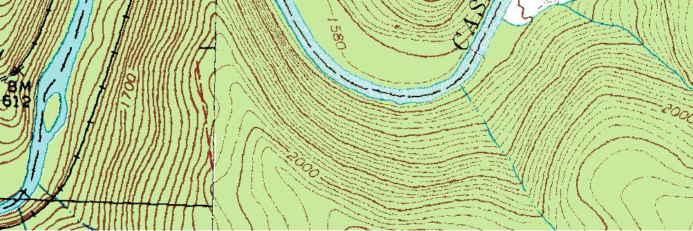
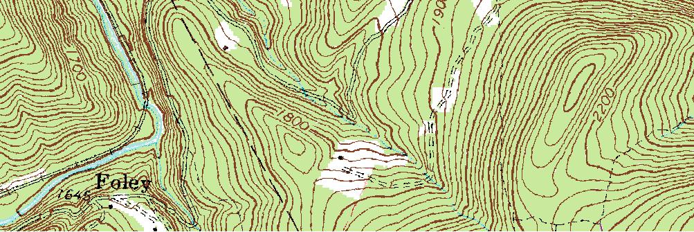
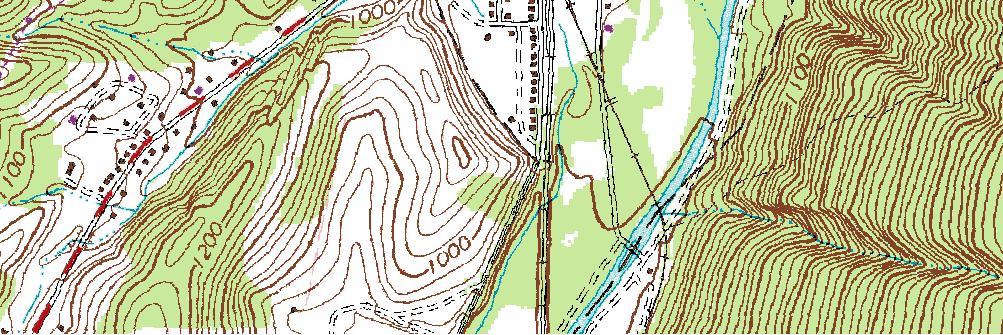
Introduction to Topographic Maps
 Introduction to Topographic Maps DIRECTIONS: Read all of the following content. READ EVERYTHING!! At the end of the packet, you will find two topographic maps. Your task is to indentify each of the elevations
UPPER TRACT, WEST VIRGINIA
 AVAILABLE SPACE UPPER TRACT INDUSTRIAL PARK SHELL BUILDING 2 LOCATION Building Address - 29 Industrial Park Road Upper Tract, WV 26866 Located in City Limits - No Zoning - None County - Pendleton Located
// ZONING - OHIO RIVER
 BEAVER KROLL MCKEES ROCKS // ZONING - OHIO RIVER TRACY WESTHALL CALIFORNIA SHADELAND Mixed-Use General Industrial Industrial Mixed-Use MARSHALL PERRYSVILL E EAST SWINDELL DOERR SUPERIOR STANHOPE BAGDAD
SWINGING OVER SCHUYLKILL THE HISTORY OF THE PW&B AND BRIDGE NO. 31
 THE SWINGING OVER SCHUYLKILL THE HISTORY OF THE PW&B AND BRIDGE NO. 31 The Philadelphia, Wilmington & Baltimore Railroad Company (PW&B) was formed in 1836. In 1838, the railroad was enlarged by the joining
Elevate your Environment Westlake.
 Elevate your Environment. 1101 Westlake. 1101 Westlake Lobby 1101 Westlake Lobby 1101 Westlake Views Fact Sheet BUILDING INFORMATION 1101 Westlake Avenue North Seattle, WA 98109 New Building: Completed
Welcome to the Pacific Spas family!
 Welcome to the Pacific Spas family! Your Pacific Spa has been engineered and built to the highest standards. Enjoy it regularly and experience the serenity and satisfaction that you ve wanted. The information