4 Rock River Cruise. The Ride
|
|
|
- Ferdinand McGee
- 5 years ago
- Views:
Transcription
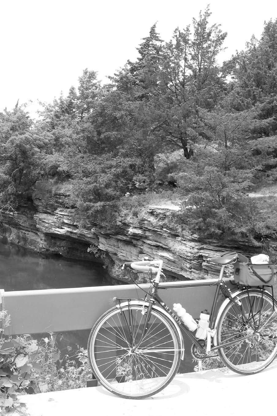
1 4 Rock River Cruise Among the many attractions on this ride are the charming town of Oregon, the John Deere Historic Site, and a handful of picturesque parks where you ll be enveloped in the local scenery. For those with an urge to explore a genuine Illinois prairie, this ride takes you past one of the largest pieces of preserved prairie in the state. Start: Mill Springs Day Use Area at Franklin Creek Natural Area, located west of Dixon. Length: 34.7 miles. Terrain: Consistently rolling with a few small climbs. Traffic and hazards: The first and last mile of the route is dirt road. Use caution on the brief segments of the route along SR 2 and SR 64. Both of these roads are fairly busy. Getting there: From Chicago and points east, take I-88 (East-West Tollway) west to Rochelle. Exit north on SR 251 and turn left (west) on SR 38. Follow the highway to Franklin Grove and turn right on State Street (CR 25). Quickly turn left on Old Mill Road, which takes you into the Franklin Creek Natural Area. Look for the Mill Springs Day Use Area on the left. Coordinates for starting point: 16T E N The Ride The ride starts at Franklin Creek Natural Area, a lovely park little known outside of the immediate area. Either at the end or the beginning of the ride, be sure to explore the path in back of the parking area. This paved trail follows picturesque Franklin Creek to springs where water emerges from under a rock outcropping on the side of a hill. As you re heading out of the park, you ll pass a newly rebuilt gristmill modeled after the original cornmeal- and flour-producing mill built at the site in Unlike many gristmills that have been rebuilt, this one uses the same technology as the original mill: Water turns the four-ton wheel located outside the mill, and the turning of the wheel powers the gears, belts, and a vertical shaft that turn the grinder on the first floor. As you re leaving the mill, look to the left for some rocky outcroppings above Franklin Creek. The next several miles of riding takes you across a series of creeks and through rolling terrain that is part of the Nachusa Grasslands, one of the largest prairie remnants in Illinois (toward the ride s end you ll have the opportunity to explore more of this prairie). After crossing the Rock River, consider dropping in at the John Deere museum, which includes the former residence and blacksmith workshop of this agricultural icon. There s also a series of exhibits focusing on Deere s main innovation in 1837: changing plow blades from iron to steel. Steel worked better because the rich Midwest soil didn t cling to the steel blade as it did to the iron blade. While it seems Ride 4 Rock River Cruise 27
2
3 like a modest contribution to farming technology, by all accounts Deere s plow did work better, and thereby hastened the settlement of the Midwest and the prairie in particular. Continuing over the gently rolling landscape north toward Oregon, occasional views open up as you pass small farms, pastures, old barns, and patches of thick woodland. More long views appear on Oregon Trail Road. In particular, you ll see a couple landmarks in the town of Oregon: the Ogle County Courthouse and the bluffs above the Rock River. Before crossing the Rock River again in Oregon, you may want to take a closer look at the handsome courthouse, built in The courthouse lawn contains a monument by the Illinois artist Laredo Taft. Oregon claims several works by Taft, the best one located just 1.5 miles north of town in Lowden State Park. The 50-foot concrete statue of a Native American often identified as Black Hawk is perched dramatically on a bluff overlooking the Rock River (see Miles and Directions for this worthwhile side trip). Turning onto Lowden Road, the traffic quiets down considerably as you ride under a canopy of oak and hickory toward Lowden-Miller State Forest. This forest once belonged to Frank Lowden, a former U.S. congressman and Illinois governor. Lowden lived for a time on the property with his family (Lowden s wife, Florence, was the daughter of George Pullman, the owner of the Chicago train car manufacturer). The Nachusa Grasslands a 2,500-acre natural area that is owned and operated by the Nature Conservancy appears on the right during the last several miles of the ride. An information kiosk is located at the visitor entrance on Lowden Road, just past the entrance to the preserve s office. Occasional sandstone outcrops as well as rocky soil and streams made this grassland difficult to farm and saved large pieces of it from the plow. From the parking area, take a short walk on the mowed path up to the high point to take in the subtle drama of the landscape s rolling green waves. You ll see birds chirping madly and dashing among the compass plants, spiderworts, and coneflowers. From the grassland, it s a short trip back to Franklin Creek. Miles and Directions 0.0 Turn left on Old Mill Road from the Mill Springs Day Use Area at Franklin Creek Natural Area. 0.2 Turn right on Twist Road. 1.3 Turn left on Naylor Road. 4.3 Turn right on Maples Road, then make a quick right on Lost Nation Road. 4.5 Turn left on Grand Detour Road. 6.2 Turn right on SR 2. Rocky outcroppings adorn the banks of Franklin Creek. Ride 4 Rock River Cruise 29
4 Rock River Cruise km. N mi. LOWDEN STATE PARK 64 N River Rd 15.6 Oregon Trail Road Oregon 20.5 Pines Road Daysville Rd 64 Daysville CASTLE ROCK STATE PARK LOWDEN-MILLER STATE FOREST Lowden Road 22.8 Nashusa Road Ridge Road Scott Road 26.8 Lighthouse Road 27.8 Rock River Lost Lake Lowden Road Flagg Road Grand Detour John Deere Historic Site 2 Grand Detour 7.2 Franklin Creek Nachusa Grasslands Rd / Lost Nation Rd Naylor Road Naylor Road 4.3 Maples Road 0.2/ 34.5 Twist Road 4 FRANKLIN CREEK NATURAL AREA Old Mill Rd Franklin Grove
5 7.2 Turn left on Broad Street. 7.4 Turn right on Ridge Road. Several miles ahead, pass a parking area for hiking trails that are part of Castle Rock State Park Turn right on Oregon Trail Road. In Oregon, Oregon Trail Road becomes Monroe Street Turn right on 3rd Street Turn left on SR 64. Crossing the Rock River, take the pedestrian/bike path on the left Side trip: Go 1.5 miles north on River Road to Lowden State Park to see the towering statue of a Native American. Ride carefully on River Road it can be busy Turn right on Daysville Road Turn right on Lowden Road Turn right on Nachusa Road Turn left on Scout Road. Side trip: For a fairly quick trip to the Rock River, keep straight ahead on Nachusa Road past Scout Road. You ll have to walk your bike for a half mile to the river; the park does not allow bicycling on the trails Turn left on Lighthouse Road Turn right on Lowden Road Nachusa Grasslands kiosk and trailhead. 33 Turn right on Naylor Road Turn left on Twist Road Turn left on Old Mill Road 34.7 Return to Mill Springs Day Use Area. Local Information Blackhawk Waterways Convention and Visitors Bureau: 201 North Franklin Ave., Polo; (800) or (815) ; Lee County Tourism: 113 South Peoria Ave., Dixon; (815) ; county.com. Local Events/Attractions Franklin Creek Natural Area Grist Mill: Milling demonstrations; open on weekends; 1872 Twist Rd., Franklin Grove; (815) ; http ://dnr.state.il.us/lands/landmgt/parks/r1 /franklin.htm. John Deere Historic Site: The gift shop has that pair of John Deere oven mitts you ve always wanted; South Main, Grand Detour; (815) ; site. Nachusa Grasslands Preserve: Volunteers and staff conduct periodic tours, bird walks, and other special events; 8772 South Lowden Rd., Franklin Grove; (815) Restaurants La Vigna: Italian food; located on the route 2190 South Daysville Rd., Oregon; (815) White Pines Lodge Restaurant: Home-style fare; occasional dinner theater; 6712 West Pines Rd., Mount Morris; (815) ; Accommodations Chateau Lodge: 1326 SR 2, Oregon; (815) ; The Patchwork Inn: 122 North Third Street, Oregon; (815) ; White Pines Inn/White Pines Forest State Park: One of the oldest Illinois state parks offers camping, cabins, and a restaurant (see above); 6712 West Pines Rd., Mount Morris; (815) Ride 4 Rock River Cruise 31
6 Bike Shops Green River Adventure Sports: 148 South Peoria Ave., Dixon; (815) ; riveradventuresports.com. Restrooms Start/finish: The Mill Springs Day Use Area has restrooms and a water fountain. Mile 6.7: John Deere Historic Site has restrooms and water. Mile 18.6: Oregon Park West has restrooms and water. Mile 25.5: Equestrian area at Lowden-Miller State Forest has a portable toilet. Maps USGS: Franklin Grove quad, Daysville quad, Dixon East quad, Grand Detour quad, Oregon quad. DeLorme: Illinois Atlas & Gazetteer: Pages 25 and Rockford Ramble Get a full taste of the Rockford area while touring newer suburbs, older residential neighborhoods, and many acres of parkland. The highlight of this ride is a 7-milelong path that winds along the grassy banks of the Rock River. While passing through downtown Rockford, you ll have an opportunity to check out a few quality museums clustered together across the river. Start: Rock Cut State Park, located at the northeast edge of Rockford. Length: 30.1 miles. Terrain: Mostly flat and gently rolling; a few small hills appear along the way as well. Traffic and hazards: About 19 miles of this route follow paved paths; the rest of the route is on quiet side streets. While following the path on Charles Street, keep an eye peeled for cars pulling into the path at driveways and cross streets. Getting there: From I-39/90 northwest of Rockford, exit west on SR 173. Enter the park on the left and turn right where the park road splits. Follow signs to the Lakeview Picnic Area. Park in the lot on the left, near the shore of Pierce Lake. Catch the beginning of the trail across the park road from the parking area. Coordinates for starting point: 16T E N The Ride As the third-largest city in Illinois, Rockford claims a rich history as a Midwestern manufacturing center. While much of the manufacturing is gone, Rockford remains vibrant, with a handful of historic neighborhoods built during a time when the city s economic engine was purring. The city also has a collection of burgeoning suburbs and an active downtown area. The main focus of the city is the big, wide Rock River, which winds through the center of the city and a variety of neighborhoods. The ride begins on the shore of Pierce Lake within Rock Cut State Park. The park is packed with trails, fishing spots, and picnic areas as well as hills, creeks, and large swaths of rehabilitated prairie. The initial stretch of trail takes you through lush 32 Road Biking Illinois
Matthiessen State Park Dells Area Hike
 90 Easy Hikes Close to Home At the south end of the hike, you ll climb on top of a mound left over from a former coal-mining operation in the park. Not far from Goose Lake Prairie, the town of Morris hosts
23 Jubilee College Challenge
 Accommodations Jubilee College State Park: Many campsites; 13015 West Fussner Rd., Brimfield; (309) 446-375; http://dnr.state.il.us/lands/landmgt /parks/r1/jubilee.htm. Old Church House Inn: Bed-and-breakfast
Lava Mountain Trail Distance: Elevation Range: Trail Type: Difficulty: Season: Driving Distance: Driving Time: USGS Maps: Pros Cons
 Lava Mountain Trail Distance: 13.4 miles (including the side trip to North Star Lake) Elevation Range: 5900'-8330' Trail Type: singletrack Difficulty: moderate Season: late June-October Driving Distance:
AOTA ArtTrek Locations
 AOTA ArtTrek Locations ArtTrek is a summer-long Grand County, CO art adventure. Highlighted by snow-covered mountain vistas and rolling meadows threaded with sparkling streams and rivers, numerous sites
Difficult Run Stream Valley Park
 Difficult Run Stream Valley Park The more intense mountain bikers have known about for Difficult Run for some time. Equestrians have known it longer. Eight miles of unpaved trail, the Rails to River Trail
Cincinnati Nature Center s
 120 60 hikes within 60 miles: cincinnati 24 Cincinnati Nature Center s Rowe Woods i KEY AT-A-GLANCE INFORMATION Length: 8.9 miles Configuration: Loop Difficulty: Difficult Scenery: Forest, ponds, prairie,
Black Hill Regional Park, Little Seneca Lake
 Black Hill Regional Park, ittle Seneca ake ittle Seneca ake, in Black Hill Regional Park, is a reservoir created after a previous drought struck the Washington area. The park is under Maryland-National
Asheville & WNC Hikes
 Asheville & WNC Hikes Amazingly, we have 3,000+ miles of free public hiking trails near Asheville, including 1,600 miles in the Pisgah and Nantahala National Forests, 850 miles in Great Smokey Mountains
Route #2) Mt. Massive - Southwest Slopes
 Mt. Massive - Southwest Slopes") Route #2) Mt. Massive - Southwest Slopes Difficulty: Class 2 Ski: Advanced, D6 / R2 / III Exposure: Summit Elevation: Trailhead Elevation: Elevation Gain: Round-trip Length: Trailhead: County Sheriff:
Route #2) Mt. Massive - Southwest Slopes Difficulty: Class 2 Ski: Advanced, D6 / R2 / III Exposure: Summit Elevation: Trailhead Elevation: Elevation Gain: Round-trip Length: Trailhead: County Sheriff:
Baltimore County Nature Quest NEW TRAILS 2014
 Baltimore County Nature Quest NEW TRAILS 2014 Nature Quest Park Locations Robert E. Lee Park Cromwell Valley Park Agricultural Ctr. & Farm Park Honeygo Regional Park Marshy Point Park and Nature Center
To Wellness. To Wellness PASSPORT PASSPORT. Partners. Partners. Ashland County Health & Human Services 630 Sanborn Avenue, Ashland, WI
 Partners Ashland County Health & Human Services 630 Sanborn Avenue, Ashland, WI Ashland Bretting Center 320 4th Avenue W., Ashland, WI PASSPORT Bayfield County Health Department 117 E. 6th Street, Washburn,
Stephens State Park Trails
 TRAILS OF ALLAMUCHY MOUNTAIN & STEPHENS STATE PARKS Allamuchy Mountain and Stephens State Parks contain 28 marked trails providing access to diverse landscapes for walking, hiking, biking, bird-watching,
This Passport: Revised October 20, 2017, EAM # Discovering the Trails of Penfield, NY
 This Passport: Revised October 20, 2017, EAM #161922 Discovering the Trails of Penfield, NY The Town of Penfield is fortunate to have a wide variety of natural resources which make for many unique and
F.O.K.O.S. Friends of Kingston Open Space A GUIDE TO KINGSTON OPEN SPACE
 F.O.K.O.S. Friends of Kingston Open Space A GUIDE TO KINGSTON OPEN SPACE Friends of Kingston Open Space (FOKOS) was formed when a handful of concerned citizens joined together to learn what could be done
Tiger Mountain State Forest:
 98 60 hikes within 60 miles: SEATTLE 20 Tiger Mountain State Forest: West Tiger Mountain Three Loop i KEY AT-A-GLANCE INFORMATION Length: 5.1 miles round-trip Configuration: Loop Difficulty: Moderate difficult
SECTION 1: MARYLAND TO PA nd CROSSING MASON DIXON LINE TO RAINSBURG GAP BUCHANAN STATE FOREST, PRIVATE LAND, SGL 97
 SECTION 1: MARYLAND TO PA 326 2 nd CROSSING MASON DIXON LINE TO RAINSBURG GAP BUCHANAN STATE FOREST, PRIVATE LAND, SGL 97 Web Update, August 2010 http://www.hike mst.org Section 1 follows Tussey Mountain
Film Location Prospectus
 Film Location Prospectus NYS Park s Taconic Region in New York s Hudson Westchester, Putnam, Dutchess & Columbia Counties www.parks.ny.gov Janeen M. Martin Marketing/PR Coordinator, Taconic Region 9 Old
43 STONE MOUNTAIN LOOP
 204 60 hikes within 60 miles: atlanta 43 STONE MOUNTAIN LOO i KEY AT-A-GLANCE INFORMATION LENGTH: 5.5 miles CONFIGURATION: Loop DIFFICULTY: Easy SCENERY: Views of Stone Mountain and Confederate Memorial;
H U D S O N P A L I S A D E S
 14 H U D S O N P A L I S A D E S Hudson Palisades The southernmost sections of the Long Path follow the Hudson River and the Hudson Palisades north, staying close to the river and to civilization. Although
IOWA ORNITHOLOGISTS' UNION - Birding Sites in Linn County
 IOWA ORNITHOLOGISTS' UNION - Birding Sites in Linn County Printed on 6/15/2018 Bever Park (ebird Hotspot) GPS Coordinates: 41.9851219,-91.6269125 Restrooms Parking Trails ADA Accessible Trails Boyson Trail
Municipal Park Descriptions: 1. Bear Hollow Park 4100 Bear Hollow Park Court, Murrysville, PA acres
 MUNICIPAL PARK DESCRIPTIONS Murrysville has a wide variety of parks and recreational facilities including sports fields, neighborhood parks, community parks, a Community Center, and extensive natural areas
Bratt ") 4. % F l o r i d a D e s i g n a t e d P a d d l i n g T r a i l s ") 164 «97 ") 99. Barrineau Park. M a p 1. M a p 2.
 4. % F l o r i d a D e s i g n a t e d P a d d l i n g T r a i l s ) 164 «97 ) 99. Barrineau Park. M a p 1. M a p 2.") F l o r i d a D e s i g n a t e d P a d d l i n g T r a i l s Bratt ") 4 Bluff Springs «4 Jay ") P e r d i d o R i v e r P e r d i d o CR R99A i v Walnut e r Hill ") 164 ") 97A «89 «97 ") 197 Barrineau
F l o r i d a D e s i g n a t e d P a d d l i n g T r a i l s Bratt ") 4 Bluff Springs «4 Jay ") P e r d i d o R i v e r P e r d i d o CR R99A i v Walnut e r Hill ") 164 ") 97A «89 «97 ") 197 Barrineau
Camping (Primitive) Camping (RV) Electrical Potable Water Grill Established Fire Pit Picnic Table
 Camping (RV) Electrical Potable Water Grill Established Fire Pit Picnic Table") Alden - 9th Road River Mile 777 Map: 38.20833, -98.32031 Managing Agency: Kansas Department of Wildlife, Parks & Tourism Nearest Community: Alden, Rice County Kansas Developed Amenities Provided Parking
Alden - 9th Road River Mile 777 Map: 38.20833, -98.32031 Managing Agency: Kansas Department of Wildlife, Parks & Tourism Nearest Community: Alden, Rice County Kansas Developed Amenities Provided Parking
Delaware Wildlife Area
 Delaware Wildlife Area 8 miles away from Delaware 4,670 acre Wildlife Area 1) Take Rt. 36/East Williams Street eastward 2) Take left onto Rt. 42/Lake Street 3) Slight left onto Horseshoe Rd./CR. 220 4)
MOAB peopleforbikes.org/e-bikes
 emtb ADVENTURE MAPS MOAB peopleforbikes.org/e-bikes OVERVIEW Moab, Utah is a world-class mountain bike destination known for its vast, red sandstone landscapes nestled below the rising peaks of the La
Segment 2: La Crescent to Miller s Corner
 goal of the USFWS refuges is to conserve, protect and enhance fish, wildlife and plants and their habitats for the continuing benefit of the American people. Refuge lands are used largely for fishing,
Chapter 2: Summary of Existing Open Space System
 Chapter 2: Summary of Existing Open Space System In 1976, the Wake County Board of Commissioners established the Wake County Parks and Recreation Department in order to provide park facilities and programs
Route #1) Mt. of the Holy Cross - North Ridge
 Mt. of the Holy Cross - North Ridge") Climbing 14ers can be very dangerous, please read the Mountaineering Safety Page and make sure you have a map+compass and can use them effectively, without the help of electronic devices. Route #1) Mt.
Climbing 14ers can be very dangerous, please read the Mountaineering Safety Page and make sure you have a map+compass and can use them effectively, without the help of electronic devices. Route #1) Mt.
TAYLOR CANYON RANCH COLORADO - ROUTT COUNTY - STEAMBOAT SPRINGS
 TAYLOR CANYON RANCH COLORADO - ROUTT COUNTY - STEAMBOAT SPRINGS Tucked up against the steep valley shaped by Mt. Pau and rising to the Routt National Forest, Taylor Canyon Ranch is an easily accessible,
This Passport: Revised October 20, 2017, EAM # Discovering the Trails of Webster, NY
 This Passport: Revised October 20, 2017, EAM #161923 Discovering the Trails of Webster, NY The Town of Webster invites you to explore and experience our diverse outdoor adventures! Here s your opportunity
S H A W A N G U N K R I D G E T R A I L
 214 Shawangunk Ridge Trail The Shawangunk Ridge Trail was originally conceived as a relocation of the Long Path from Harriman State Park to Minnewaska State Park. Now part of the Long Path system, the
UMASS CROSS-COUNTRY Trails
 UMASS CROSS-COUNTRY Trails 1) EGG (43 min) (A) From Cage proceed to North Pleasant street (by campus pond). Make left and head toward LGRT and pass School of Education. Pass Puffton Apt complex (on left)
San Luis Obispo. Bishop Peak Felsman Loop Eagle Rock Maino Open Space Poly Canyon Poly P Other Areas
 San Luis Obispo Bishop Peak Felsman Loop Eagle Rock Maino Open Space Poly Canyon Poly P Other Areas 1 JCT. ELEV. 72 400 00 0 FELSMAN LOOP GATE LOOP RIDGE 600 FENCE JCT. ELEV. 860 1000 1200 BISHOP PEAK
Little Grand Canyon near Pomona, Illinois
 Little Grand Canyon near Pomona, Illinois Below: View of the trail and the terrain created using the Map My Hike app Below: Summary of the hike created using the Map My Hike app Presented by: Jennifer
1 of 6 9/20/2013 9:32 AM
 1 of 6 9/20/2013 9:32 AM 1 Illinois RV Parks and Campgrounds Hillcrest Golf & Camping Resort Brief Description: Our campgrounds offer a wide selection of spacious, level sites with picnic tables, water
IOWA ORNITHOLOGISTS' UNION - Birding Sites in Dallas County
 IOWA ORNITHOLOGISTS' UNION - Birding Sites in Dallas County Printed on 7/19/2018 Beaver Bottoms Wetland (restricted) (Important Bird Area) GPS Coordinates:, Ownership: Private (see directions for access)
Drive and Stop Routes
 Drive and Stop Routes Limantour Road 1 - easy and likely productive. From Bear Valley Visitor Center drive back out and turn left onto Bear Valley Rd. Turn left at Limantour Road (the first road). Drive
A Day Trip to Silver Falls State Park and Silverton
 A Day Trip to Silver Falls State Park and Silverton One of my favorite Portland day trips is Salem area s Silver Falls State Park. Quite simply, this is a park I make a point to visit at least once a year.
Route Combo) Mt. Bierstadt - Bierstadt, Sawtooth, Evans
 Mt. Bierstadt - Bierstadt, Sawtooth, Evans") Climbing 14ers can be very dangerous, please read the Mountaineering Safety Page and make sure you have a map+compass and can use them effectively, without the help of electronic devices. Route Combo)
Climbing 14ers can be very dangerous, please read the Mountaineering Safety Page and make sure you have a map+compass and can use them effectively, without the help of electronic devices. Route Combo)
Ortiz River Ranch Pagosa Springs, Colorado
 Ortiz River Ranch Pagosa Springs, Colorado This ranch provides an exceptional opportunity to own a property with frontage on the San Juan and Navajo Rivers, lush irrigated pastures, and beautiful rolling
Androscoggin River Trail Access Sites. North Woods. 168 miles from its source at Lake Umbagog to Merrymeeting Bay
 Androscoggin River Trail Access Sites North Woods 168 miles from its source at Lake Umbagog to Merrymeeting Bay Trail Under Construction More than 40 Public Access Sites Available Androscoggin River Watershed
Bureau of Land Management Public Lands Guide Northwest District
 Bureau of Land Management Public Lands Guide Northwest District NORTHWEST Fee Site Restrooms Picnic Sites Developed Campgrounds Farmington Field Office (505) 564-7600 Alien Run Mountain Bike Trail Angel
Exploring the Natural Wonders of Arizona
 5 Days / 4 Nights DEVELOPED FOR Couples and Families HIGHLIGHTS Full Day Private Tour of Grand Canyon National Park Shared Helicopter Flightseeing Tour over the Canyon 2-Hour Private 4x4 Jeep Tour on the
weekend ADVENTURE Saturday: ARRIVAL (Friday):
:") weekend ADVENTURE Saturday: ARRIVAL (Friday): Welcome to beautiful, mountainous, and unique Harlan, Kentucky! Your adventure begins by checking into one of the beautiful cabins at Putney Trailhead (606)
weekend ADVENTURE Saturday: ARRIVAL (Friday): Welcome to beautiful, mountainous, and unique Harlan, Kentucky! Your adventure begins by checking into one of the beautiful cabins at Putney Trailhead (606)
Topsham Trail Guide.
 Topsham Trail Guide A guide to the walking, hiking, biking, water and ATV trails of Topsham, Maine and surrounding towns $4.95 Developed by the www.greatertopshamtrailalliance.org The Greater Topsham Trail
A Publication of Friends of Sleeping Bear Dunes
 A Publication of Friends of Sleeping Bear Dunes 2014, Friends of Sleeping Bear Dunes, P.O. Box 545, Empire, MI 49630 www.friendsofsleepingbear.org info@friendsofsleepingbear.org Learn more about the Friends
2. Buck s Overnight Lodge - A nice place to stay on 300 acres.
 FENTRESS COUNTY Major Draws to the area: A. The horse back riding trails through the Big South Fork B. Sgt Alvin York C. The Hwy 127 Longest Yard Sale through 5 states. Fentress County started it and hosts
Beautiful Walks from the Blue Ball Inn
 Walk No. 5 RIVER VALLEYS AND MOOR Countisbury, Watersmeet, Hillsford Bridge, Cheriton, Shilstone Hill, Rockford and Chiselcombe. 8.5 MILES APPROX. Walking time four and a half hours approx. OS 1;25,000
Rogue Gorge (Mt. Stella) Roadless Area-- T30S R3E (primarily in portions of Sections 23, 26, 33, 34 & 35)
 Roadless Area-- T30S R3E (primarily in portions of Sections 23, 26, 33, 34 & 35)") Rogue Gorge (Mt. Stella) Roadless Area-- T30S R3E (primarily in portions of Sections 23, 26, 33, 34 & 35) Rogue River-Siskiyou National Forest--High Cascades Ranger District Upper, higher elevation trail
Rogue Gorge (Mt. Stella) Roadless Area-- T30S R3E (primarily in portions of Sections 23, 26, 33, 34 & 35) Rogue River-Siskiyou National Forest--High Cascades Ranger District Upper, higher elevation trail
HIGH POINT STATE PARK
 State of New Jersey, Department of Environmental Protection Division of Parks and Forestry State Park Service njparksandforests.org HIGH POINT STATE PARK TRAILS OF HIGH POINT STATE PARK There are thirteen
Eakin Community Park. Getting There
 Eakin Community Park Quiet woods along the Accotink Creek are the hallmark of Eakin Community Park. Actually a string of smaller parks, Eakin is made-up of Mantua Park, Kern Drive Park, Eakin Park, Woodburn
West Trails Trek Guide. Chief Pontiac Trail Credential Hikes
 West Trails Trek Guide Kensington Start Edition Chief Pontiac Trail Credential Hikes RDS.WTW.110609 WP# Dist. Accum. Dist. Accum. Feet Miles Meters Meters 1 0 0.0 0 0 2 410 0.1 125 125 3 164 0.1 150 275
Beaver Country Trails ATV Jamboree
 Beaver Country Trails ATV Jamboree #1 Lincoln Mine Intermediate (Open to all ATVs/UTVs) 34 Miles Highlights: This ride will highlight the historic Lincoln Mining District, the first lead mine in Utah,
Field Guide. Nature Nearby. Traverse City
 Field Guide Nature Nearby Traverse City FEATURED PROPERTIES 1 DEEPWATER POINT NATURAL AREA 2 HICKORY MEADOWS NATURAL AREA KALKASKA 3 MAPLE BAY NATURAL AREA E as t A rm G r a n d Tr a v er s e B ay 4 PELIZZARI
WATER PETALUMA TRAIL WATER WAYS PROJECT PORTFOLIO. petalumawaterways.org OVERVIEW
 WATER TRAIL PROJECT PORTFOLIO OVERVIEW Thirteen miles upstream of San Pablo Bay, Petaluma is the northern point on the San Francisco Bay Water Trail, a network of access points throughout the region. Most
Crystal Lake Area Trails
 Lake Area Trails Welcome to the Lake area of the Big Snowy Mountains! This island mountain range in central Montana features peaks reaching to 8,600 feet and long, high ridges from which vistas of the
Jackson Miles Abbott Wetlands Refuge/Fort Belvoir
 Jackson Miles Abbott Wetlands efuge/fort Belvoir Over the course of millions of years the Potomac iver has gradually shifted its course and sediments have filled-in its old river bed. The main river once
INTERMEDIATE. mayorsmtbchallenge.org
 mayorsmtbchallenge.org Redding s second local Mountain Bike Challenge uniting current and new bicyclists in a friendly self-competition highlighting our diverse trail system. INTERMEDIATE Mule Ridge Cosmos
Beaver Creek State Park
 GENERAL INFORMATION Name of Park/Forest/Facility: Beaver Creek State Park County: Columbiana (St. Clair Township) Address: 12816 Sprucevale Road (ie County Rd 428) (street #, city) East Liverpool, Ohio
Driving Time: 3 hours (allow extra time for stops)
") Scenic Byways loop This journey takes visitors through the eastern edge of Mt. Rainier National Park and along two of Washington s most beloved scenic byways, the Chinook Byway and the White Pass Scenic
Scenic Byways loop This journey takes visitors through the eastern edge of Mt. Rainier National Park and along two of Washington s most beloved scenic byways, the Chinook Byway and the White Pass Scenic
Windsor Kingsville Essex Tour:
 An Ontario's Southwest Cycling Itinerary Windsor Kingsville Essex Tour: Pedal into the Heart of Southern Ontario s Wine Country CYCLE LOTS TO SEE AND LOTS TO DO IN ONTARIO S SOUTHWEST Total Distance: 130
Weston County, Wyoming
 The Sweet 200-Acre Property Weston County, Wyoming A unique opportunity to own a little piece of the old West, where one can experience unparalleled scenery, adventure and history walk in the footsteps
name suggests, it s home to some really
 Coloring Book Great Rivers Country covers 33 counties on the western part of Illinois and like the name suggests, it s home to some really great rivers, including the Mississippi, Illinois, Ohio, Rock,
2. Goals and Policies. The following are the adopted Parks and Trails Goals for Stillwater Township:
 D. PARKS AND TRAILS 1. Introduction Stillwater Township s population is relatively low, with most residents living on rural residences on large lots. The need for active park space has been minimal in
Lewis and Clark Recreation Area
 Lewis and Clark Recreation Area Bicycle/Pedestrian Trail Also part of the Pierson Ranch Recreation Area trail Type of trail: Walking, biking and rollerblading Trail surface: Asphalt Rated: Mostly flat.
Lake Wissota Access Locations within the LaFayette Township. By Chad Martin
 Lake Wissota Access Locations within the LaFayette Township By Chad Martin Anson/ Wissota Access Point # 1 Road: 195 th St. Associated Fire Numbers: 13294 Defining Characteristics: Forested from road
Brinker Creek Ranch. Colorado - Routt County - Yampa
 Located at the base of the Flattops Range in the Steamboat/Vail corridor, Brinker Creek Ranch consists of 1,451 acres ideally suited for high country grazing and native grass hay production. Traditionally
Calvert Regional Park - Tari Moore Recreational Trail. Calvert Regional Park - Woodland Trail. miles from Rising Sun
 Calvert Regional Park - Tari Moore Recreational Trail 304 Brick Meeting House Road, North East, MD 21901 5.2 about 1.1 mile Paved parking lot, plentiful Easy, paved path with slight incline. Easy, paved
The gorges of Mohican Park in Ohio create a hiker's paradise Sunday, May 22, 2011 By Bob Downing, Akron Beacon Journal
 Pittsburgh Post-Gazette The gorges of Mohican Park in Ohio create a hiker's paradise Sunday, May 22, 2011 By Bob Downing, Akron Beacon Journal Bob Downing Big Lyons Falls drops 80 feet into a shady U-shaped
VENICE TO ROME CYCLE ABOUT THE CHALLENGE ITALY CYCLE TOUGH
 ITALY CYCLE TOUGH ABOUT THE CHALLENGE Our exciting challenge takes us south on flat roads from the canals of Venice to the rolling hills of Tuscany and Umbria, passing terracotta-roofed towns and small
Rock Creek Park, MD - Lake Needwood
 ock Creek Park, MD - Lake Needwood Lake Needwood, is a reservoir located at the end of the north end of the ock Creek hiker-biker trail. At the other end, ock Creek empties into the Potomac iver near Thompson
The Narrows Waterfront Park A Crown Jewel for Southern Brooklyn
 The Narrows Waterfront Park A Crown Jewel for Southern Brooklyn In New York, the unquestioned popularity of urban spaces such as Riverside Park, the High Line, Brooklyn Bridge Park and others has demonstrated
Best Hikes on Orcas Island
 Published on San Juan Islands Washington Visitors Bureau Orcas Island Lopez Island Friday Harbor San Juan Island (https://www.visitsanjuans.com) Best Hikes on Orcas Island The Emerald Isle offers big trees,
Kitimat. Pacific Inland Coast. Hiking Guide Kitimat, British Columbia, Canada
 Kitimat Pacific Inland Coast Hiking Guide Kitimat, British Columbia, Canada 2010-2011 Sites and Trails Emergency Call 911 Police - Fire - Medical 2 Welcome to Kitimat This information was produced to assist
Bikes talk to each other like dogs, they wag their wheels and tinkle their bells, the riders let their mounts mingle.
 Bikes talk to each other like dogs, they wag their wheels and tinkle their bells, the riders let their mounts mingle. Daniel Behrman, The Man Who Loved Bicycles W hitmore Lake Loop route: Dexter, the corner
Nature is for everyone to enjoy, so let your followers experience the beauty.
 POCKET GUIDE WHILE YOU RE HIKING For your safety, please watch for loose rocks, tree roots, and other obstacles along the trails. Please park in designated parking areas only. Stay on the marked trail;
Welcome to Schmeeckle Reserve!
 Welcome to Schmeeckle Reserve! This 280-acre natural area is staffed by University of Wisconsin-Stevens Point students. The Reserve protects habitat for native plant and animal communities, serves as a
Anderson Mt. Proposed Wilderness Additions to the Rogue-Umpqua Divide Wilderness-- T30S R3E (mostly) Sections 4 & 9, and T29S R3E Section 33
 Sections 4 & 9, and T29S R3E Section 33") Anderson Mt. Proposed Wilderness Additions to the Rogue-Umpqua Divide Wilderness-- T30S R3E (mostly) Sections 4 & 9, and T29S R3E Section 33 When the 35,701 acre Rogue-Umpqua Divide Wilderness was designated
Anderson Mt. Proposed Wilderness Additions to the Rogue-Umpqua Divide Wilderness-- T30S R3E (mostly) Sections 4 & 9, and T29S R3E Section 33 When the 35,701 acre Rogue-Umpqua Divide Wilderness was designated
Bryce Canyon Country ATV Multi-Day Itinerary
 Bryce Canyon Country ATV Multi-Day Itinerary Look for more trail information and maps on these web-sites listed below. www. Casto Canyon Kick off your ATV adventure with this 36 mile round-trip ride through
Paskapoo Slopes and Natural Area
 Paskapoo Slopes and Natural Area Along the western boundary of Calgary, rising above Sarcee Trail and the Trans-Canada Highway is an escarpment known as the Paskapoo Slopes. The area is a significant natural,
YAMAHA WINCH MOUNT KIT. Installation Instructions KIT NUMBER:
 YAMAHA WINCH MOUNT KIT Installation Instructions KIT NUMBER: 25-5160 CUSTOMER MUST RECEIVE A COPY OF THIS INSTRUCTION MANUAL AT TIME OF SALE 2005 CYCLE COUNTRY ACCESSORIES CORP. Rev. 2 9/22/06 Please Note:
Field Trips
 2017 2018 Field Trips www.yourmetroparks.net 513.867.5835 The mission of the MetroParks of Butler County is to provide a superior park system that maximizes the community s quality of life through conservation,
Æÿ U Æ% Sauk Point @ Segment Merrimac. Æÿ DL. Devil's Lake. State Park. Gibraltar.
 MARQUETTE Æ% 23 French Creek Wildlife Area Dells Æ% 127 Æÿ H Æÿ F (/ 51 Lake Delton Æÿ Æ% 16 90 Mirror Lake State ark Western Bifurcation Æ% 23 ortage ortage Canal 94 ine Island Wildlife Area Eastern Bifurcation
MASTER PLAN EXECUTIVE SUMMARY
 Biscuit Run State Park Scottsville Road (State Route 20) Charlottesville, VA 22902 Biscuit Run State Park MASTER PLAN EXECUTIVE SUMMARY Department of Conservation and Recreation Division of Planning and
FINAL TESTIMONY 1 COMMITTEE ON RESOURCES UNITED STATES HOUSE OF REPRESENTATIVES. July 13, 2005 CONCERNING. Motorized Recreational Use of Federal Lands
 FINAL TESTIMONY 1 STATEMENT OF DALE BOSWORTH CHIEF Of the FOREST SERVICE UNITED STATES DEPARTMENT OF AGRICULTURE Before the SUBCOMMITTEE ON FORESTS AND FOREST HEALTH And the SUBCOMMITTEE ON NATIONAL PARKS,
Trailside Park, Ashburn
 Trailside Park, Ashburn For an outsider, Ashburn might seem like a follow-up act to eston. It s a large planned community built at the time, outside the known limits of civilization... Vast farm fields
Blue Ridge Hiking Club - First Quarter 2018 Hikes
 Blue Ridge Hiking Club - First Quarter 2018 Hikes Monday, Jan 1: Trout Lake to Manor House & Figure 8 Trail: Meet at Trout Lake parking lot, at 9:30. (1st exit left off Parkway just south of Cone Manor
Cinque Terre (Short Break) The best walks between coloured villages and terraced vineyards TRIP NOTES 2019 Genius Loci Travel. All rights reserved.
 The best walks between coloured villages and terraced vineyards TRIP NOTES 2019 Genius Loci Travel. All rights reserved.") Cinque Terre (Short Break) The best walks between coloured villages and terraced vineyards TRIP NOTES 2019 Genius Loci Travel. All rights reserved. INTRODUCTION The Cinque Terre gets its name from the
Cinque Terre (Short Break) The best walks between coloured villages and terraced vineyards TRIP NOTES 2019 Genius Loci Travel. All rights reserved. INTRODUCTION The Cinque Terre gets its name from the
Section 7: Pick Up Where You Left Off! S-Tree Road over the Todd Road
 2018 TRACE NOTES Helpful information for your adventure on Section 7 of the Hiker Challenge. Start Point S-Tree Rd. End Point Intersection Todd Rd. / Hale Ridge Rd. WEATHER DECISION Weather Alert!!!! Potential
Milwaukee River (Washington County) Segment. Kewaskum. Æÿ B. Æÿ D Southern. Kewaskum. Segment.
 Segment. Kewaskum. Æÿ B. Æÿ D Southern. Kewaskum. Segment.") Ice Age Trail Washington County Washington County FOND DU LAC WASHINGTON Æ% 28 Æÿ H Milwaukee River (Washington County) Æÿ B Æÿ S State Forest Northern Kettle Moraine Æÿ H Æ% 28 Ice Age Trail Alliance
Ice Age Trail Washington County Washington County FOND DU LAC WASHINGTON Æ% 28 Æÿ H Milwaukee River (Washington County) Æÿ B Æÿ S State Forest Northern Kettle Moraine Æÿ H Æ% 28 Ice Age Trail Alliance
YOSEMITE TO SAN FRANCISCO CYCLE
 USA CYCLE DEMANDING ABOUT THE CHALLENGE Journey from the spectacular Yosemite National Park to the Pacific Coast, finishing with an unforgettable finish at the iconic Golden Gate Bridge into San Francisco.
BEACH & DOWNTOWN VisiTOr MAp & GuiDE Revised July 2017
 BEACH & DOWNTOWN Visitor Map & Guide Revised July 2017 How to get here DRIVING DIRECTIONS From North Take Interstate 95 South to Exit 20 Turn left onto Hollywood Boulevard (east) Proceed east 2 miles to
ANGEL PEAK SCENIC AREA
 Activities: Facilities: ANGEL PEAK SCENIC AREA Hiking, photography, watchable wildlife, camping, picnicking. Note: While formal hiking trails in the area are limited, dispersed hiking opportunities abound
Cumberland County Hiking Marathon Trail Descriptions
 Cumberland County Hiking Marathon Trail Descriptions 8/28/2017 Welcome to the 2017 Cumberland County Hiking Marathon. As you hike these trails you will enjoy a wide variety of terrain and geographical
THE REGION LAKE SUPERIOR THE GITCHI-GAMI TRAIL & THE NORTH SHORE
 LAKE SUPERIOR THE GITCHI-GAMI TRAIL & THE NORTH SHORE 7 LAKE SUPERIOR: Water covers 70% of the earth s surface area, but only 3% of it is freshwater. Saltwater makes up 97% of the earth s water supply.
The Bridestone Rocks from Lydgate
 Print this page Back to results The Bridestone Rocks from Lydgate Ancient tracks and gritstone outcrops, with terrific views of the steepsided Cliviger Valley. Distance 5 miles (8km) Minimum time 2hrs
PASSPORT. Discovering the Trails of Webster, NY
 PASSPORT to family wellness Discovering the Trails of Webster, NY Join the Friends of Webster Trails, Webster Health and Education Network, The Town of Webster and Wegmans to get moving more and enjoy
Montrose Segment (Atlas Map 67f)
") short switchbacks, then curls southward to reach the Trail access at a gate in the northwestern corner of the park s parking area near CTH-B. The moraine and the Ice ge Trail are fenced off from a heavily
short switchbacks, then curls southward to reach the Trail access at a gate in the northwestern corner of the park s parking area near CTH-B. The moraine and the Ice ge Trail are fenced off from a heavily
BRR Leg 1 (3.9 miles, Easy)
") BRR Leg 1 (3.9 miles, Easy) Min 3901 Max 4919 Ascent +21 Descent -1031 0.0 Start (Grayson Highlands State Park Visitor Center) 3.9 Grayson Highlands State Park Office & Gate, on R (EZ 1) Leg Notes: Minimal
BRR Leg 1 (3.9 miles, Easy) Min 3901 Max 4919 Ascent +21 Descent -1031 0.0 Start (Grayson Highlands State Park Visitor Center) 3.9 Grayson Highlands State Park Office & Gate, on R (EZ 1) Leg Notes: Minimal
Welcome to Schmeeckle Reserve!
 Welcome to Schmeeckle Reserve! This 280-acre natural area is staffed by University of Wisconsin-Stevens Point students. The Reserve protects habitat for native plant and animal communities, serves as a