National Register of Historic Places Registration Form
|
|
|
- George Ross
- 5 years ago
- Views:
Transcription
1 NPS Form OMB No (Rev ) Registration Form This form is for use in nominating or requesting determinations for individual properties and districts. See instructions in How to Complete the National Register of Historic Places Registration Form (National Register Bulletin 16A). Complete each item by marking "x" in the appropriate box or by entering the information requested. If any item does not apply to the property being documented, enter "N/A" for "not applicable." For functions, architectural classification, materials, and areas of significance, enter only categories and subcategories from the instructions. Place additional entries and narrative items on continuation sheets (NPS Form a). Use a typewriter, word processor, or computer, to complete all items. 1. Name of Property historic name Spring Hill Historic District other names/site number 2. Location street & number roughly bounded by MA Rte 6A, Spring Hill Rd., and Discovery Hill Rd. city or town Sandwich not for publication vicinity state Massachusetts code MA county Barnstable code 001 zip code State/Federal Agency Certification As the designated authority under the National Historic Preservation Act of 1986, as amended, I hereby certify that this nomination request for determination of eligibility meets the documentation standards for registering properties in the National Register of Historic Places and meets the procedural and professional requirements set forth in 36 CFR Part 60. In my opinion, the property meets does not meet the National Register Criteria. I recommend that this property be considered significant nationally statewide locally. ( See continuation sheet for additional comments.) Signature of certifying official/title Brona Simon Date Massachusetts Historical Commission, State Historic Preservation Officer State or Federal agency and bureau In my opinion, the property meets does not meet the National Register criteria. ( See continuation sheet for additional Comments.) Signature of certifying official/title Date State or Federal agency and bureau 4. Certification I, hereby certify that this property is: Signature of the Keeper Date of Action entered in the National Register See continuation sheet. determined eligible for the National Register See continuation sheet. determined not eligible for the National Register removed from the National Register other (explain):
2 Spring Hill Historic District 5. Classification Ownership of Property (Check as many boxes as apply) (Check only one box) Barnstable County, MA Number of Resources within Property (Do not include previously listed resources in the count.) private public-local public-state public-federal building(s) district site structure object Name of related multiple property listing (Enter "N/A" if property is not part of a multiple property listing.) N/A Contributing Noncontributing building 10 1 sites 2 0 structures 2 1 objects Total Number of contributing resources previously listed in the National Register 1 - Wing Fort House (NRIND 1976) 6. Function or Use Historic Functions (Enter categories from instructions) DOMESTIC: residence AGRICULTURE: field, outbuilding, storage EDUCATION: school RELIGION: religious facility FUNERARY: cemetery Current Functions (Enter categories from instructions) DOMESTIC: residence AGRICULTURE: field (bogs), outbuilding, storage RELIGION: religious facility FUNERARY: cemetery 7. Description Architectural Classification (Enter categories from instructions) COLONIAL: New England Colonial, Georgian EARLY REPUBLIC: Federal MID 19 TH CENTURY: Greek Revival LATE 19 TH & 20 TH CENTURY REVIVALS: Colonial Rev. LATE 19 TH & EARY 20 TH CENTURY AMERICAN MOVEMENTS: Bungalow/Craftsman Materials (Enter categories from instructions) foundation BRICK, STONE, CONCRETE walls WOOD: clapboards, shingles; SYNTHETICS, Vinyl roof ASPHALT; WOOD, shingle other Narrative Description (Describe the historic and current condition of the property on one or more continuation sheets.)
3 Spring Hill Historic District 8. Statement of Significance Applicable National Register Criteria (Mark "x" in one or more boxes for the criteria qualifying the property for National Register listing.) A Property is associated with events that have made a significant contribution to the broad patterns of our history. Barnstable County, MA Areas of Significance (Enter categories from instructions) COMMUNITY PLANNING AND DEVELOPMENT ARCHITECTURE B Property is associated with the lives of persons significant in our past. C Property embodies the distinctive characteristics of a type, period, or method of construction or represents the work of a master, or possesses high artistic values, or represents a significant and distinguishable entity whose components lack individual distinction. D Property has yielded, or is likely to yield, information important in prehistory or history. Criteria Considerations (Mark "x" in all the boxes that apply.) Property is: A owned by religious institution or used for religious purposes. B removed from its original location. C a birthplace or grave. D a cemetery. E a reconstructed building, object, or structure. Period of Significance Mid 17 th C Significant Dates n/a Significant Person (Complete if Criterion B is marked above) n/a Cultural Affiliation n/a Architect/Builder n/a F a commemorative property. G less than 50 years of age or achieved significance within the past 50 years. Narrative Statement of Significance (Explain the significance of the property on one or more continuation sheets.) 9. Major Bibliographical References (Cite the books, articles, and other sources used in preparing this form on one or more continuation sheets.) Previous documentation on file (NPS): preliminary determination of individual listing (36 CFR 67) has been requested previously listed in the National Register previously determined eligible by the National Register designated a National Historic Landmark recorded by Historic American Buildings Survey Primary location of additional data: State Historic Preservation Office Other State agency Federal agency Local government University Other Name of repository: Sandwich Public Library
4 Spring Hill Historic District Barnstable County, MA 10. Geographical Data Acreage of Property approximately 117 acres UTM References See continuation sheet. (Medfield Quad Map) (Place additional UTM references on a continuation sheet) Zone Easting Northing Zone Easting Northing Zone Easting Northing Zone Easting Northing See continuation sheet Verbal Boundary Description Boundary Justification 11. Form Prepared By name/title Gretchen G. Schuler and Eric D. Dray, preservation consultants, with Betsy Friedberg, MHC NR Director organization Massachusetts Historical Commission date August 2010 street & number 220 Morrissey Boulevard telephone (617) city or town Boston state MA zip code Additional Documentation Submit the following items with the completed form: s Maps A USGS map (7.5 or 15 minute series) indicating the property's location. A sketch map for historic districts and properties having large acreage or numerous resources. Photographs Representative black and white photographs of the property. Additional items (Check with the SHPO or FPO for any additional items) Property Owner (Complete this item at the request of the SHPO or FPO.) name multiple street & number telephone city or town Sandwich state MA zip code 02537
5 Section number 7 Page 1 7. Description Portions redacted The Spring Hill Historic District is located in the northern part of East Sandwich, MA, in an agricultural area known for its salt marshes and cranberry bogs. This rich heritage landscape retains its historical and architectural significance as well as scenic qualities in the natural and manmade land formation. The Spring Hill Historic District is bound on the north by the properties on the north side of Spring Hill Road; on the south by properties on the south side of Route 6A; on the east by cranberry bogs that front on Spring Hill Road; and on the west by the western edge of properties at 215 and 228 Route 6A, as well as marshland that fronts on Spring Hill Road before it bends to the east. This district, located in Barnstable County, comprises 93 contributing historic resources dating from the mid 17 th century (the Wing Fort House NR) through the period of significance, which ends in years from the time of listing. (N.B. The construction date for Wing Fort House was ca at the time of its listing in Given the advances in dating technology and our evolving knowledge of First Period houses, additional physical research is necessary to confirm the date of construction.) The boundaries for the district follow the lot lines of parcels including the cranberry bogs some of which are smaller than they were in the early and mid 20 th century. There are a total of 135 resources of which 93 are contributing and 42 are noncontributing. Most of the contributing resources maintain a residential use. There are no major intrusions in the district due to the consistency in size, scale, and materials of the noncontributing resources of which 25 are dwellings. Other noncontributing resources include 14 garages, barns, and other outbuildings that are consistent with contributing outbuildings, particularly due to their location towards the back of lots rather than at the street edge. There are also two institutional noncontributing buildings, one structure (a bog pumphouse), and one object. Setting The Spring Hill Historic District is an upland area situated between Sandwich Center to the west and East Sandwich to the east. It is that part of the coastal Cape Cod town that is framed by Shawme Marsh on the west and Scorton Marsh on the east, and is surrounded by salt marshes, cranberry bogs, and open fields. One river, one creek, and several ponds enrich the landscape. A network of transportation routes is laid over these natural resources. Route 6A is a two-lane main route leading in an east-west direction, while Spring Hill Road, a narrow, winding scenic road, forms an arc on the north side of Route 6A. Stone walls and mature trees line much of Spring Hill Road, and the views across marshland and bogs are important features of this historic and scenic landscape. Along the western and northern sections of Spring Hill Road the view encompasses the salt marshes all the way to the sand dunes of Spring Hill Beach where 20 th century houses overlook Cape Cod Bay. The Cape Cod Branch Railroad parallels the northern side of Route 6A, slicing through marshland and bogs, with at-grade crossings on both ends of Spring Hill Road. Other roads included in this district are also narrow, winding, and picturesque. Quaker Road now branches off of the eastern end of Spring Hill Road, opposite the Spring Hill Cranberry Bogs (MHC #939), and ends at the railroad. Quaker Road formerly crossed the tracks and led through to Route 6A the pattern is still discernable (continued)
6 Section number 7 Page 2 in the landscape and a branch of the road also led north to another connection with Spring Hill Road. A short section of the winding scenic Discovery Hill Road leading south from Route 6A is included in the district. Nye Street frames the mill pond (MHC #963) along with Spring Hill Road and Route 6A. One modern subdivision road, Juniper Hill Road, which branches off of the northern section of Spring Hill Road, is included in the boundaries of the district. It winds up to the top of Spring Hill, providing scenic prospects. Some of the road intersections have triangular grassy plots that are demonstrated on historic maps. These road patterns were formed by left- and right-turning oxcarts and wagons that made sweeping turns rather than the right angle turns of today s automobile. The triangles remain at the eastern end of Spring Hill Road, where it meets Route 6A, and at Foster Road, where it meets Spring Hill Road. The waterways in the district include Spring Hill Creek, Old Harbor Creek, and the Cow House River. Spring Hill Creek parallels Route 6A on the north side, crosses under Spring Hill Road (after passing through the mill pond), and flows northwesterly to join with Old Harbor Creek at the point where the two creeks flow out to Cape Cod Bay. Spring Hill Creek and the Cow House River, in the eastern part of the district, drain into cranberry bogs on Spring Hill Road and Route 6A. Landscape Features While there are significant landscape features throughout the district, of particular note are several distinct areas of cranberry bogs, two burial grounds, marshland along Spring Hill Creek, a mill pond, and two ponds made for flooding the bogs. The mill pond (MHC #963, 6 Spring Hill Road), nearly an acre in size, is irregular in shape and is framed by the triangle formed by Spring Hill Road on the west, Nye Street on the north, and Route 6A on the south. The mill pond was formed in the early 19 th century by damming Spring Hill Creek to provide power for the businesses that occupied the site of J.B Vodon & Son Cutting and Engraving Shop (MHC #74, 6 Spring Hill Road, photo #9). Spring Hill Creek flows through the pond from the east and curves to the north after flowing under Spring Hill Road. It forms the rear lot lines of properties along the west and north side of Spring Hill Road. The marshland (MHC #964) along the west side of Spring Hill Road extends to the river and beyond to the salt marshes north and west of the district. These memorable vistas along this scenic route contribute to the rural and coastal character of the Spring Hill Historic District. There are four distinct cranberry bogs in the Spring Hill Historic District each with a system of earthen dikes, which serve as footpaths, and drainage or irrigation ditches that channel the water flow. The 11-acre Quaker Road Cranberry Bog (MHC #952) spans two parcels at the base of Spring Hill on the western edge of Quaker Road just north of the New York, New Haven & Boston Railroad (formerly Cape Cod Railroad) tracks. Two bogs on Route 6A (separated only by the road) are now in separate ownership; however, they were first cultivated by the same owner. The Route 6A North Cranberry Bog (MHC #953), nearly three acres in size, is small compared to other bogs. It is framed by irrigation ditches bordered by the earthen dikes, and one ditch bisects the bog from south to north. The unpaved road that runs along its eastern edge to the railroad tracks was the continuation of Quaker Road, which extended to Route 6A before the railroad was laid through Spring Hill (continued)
7 Section number 7 Page 3 in Now it is a driveway accessing a modern house on the bog parcel. The Route 6A South Cranberry Bog (MHC #954), on the south side of Route 6A and slightly west of the North Bog, consists of about ten acres with a dirt road from Discovery Hill Road leading to the earthen dikes, which serve as footpaths and provide access to a small brick pumphouse and various parts of the bog. The Spring Hill Bog, (MHC #939, photo #2), now about 65 acres in size, about half of which is included in this nomination, is located on both sides of Spring Hill Road. The largest part of the bog spreads northerly from the east side of the eastern end of Spring Hill Road, and the Cow House River runs through it. Here the pattern of earthen dikes frame the bog and run parallel to the road, with the irrigation ditches running perpendicular and parallel to the dikes. A central ditch flows through the small cranberry intake house/shed (Spring Hill Road), which is a small shingled building with intake gate below its northwest corner. The building has two entrance doors: one on the west side framed by horizontal eight-light windows, and one in the south gable end. Land across Spring Hill Road is also cultivated as part of this same bog and is contiguous to additional parcels on both sides of Route 6A. Three parcels all listed as part of the Spring Hill Bog on the data sheet are in common ownership. Only about half of the large 60-acre parcel is included, which is the bog land. Much of the rest of the parcel is upland, stretching towards the coastline, and includes land that is not accessible from a public road, not visible, and not in cranberry production, hence not included in this nomination. Twin Ponds, which are located on either side of Route 6A east of the Route 6A bogs, cover about eight acres. These ponds are on parcels that are in common ownership with the Spring Hill Bog and are part of the irrigation system associated with that bog. The ponds regularly change in size depending upon the need for flooding of the cranberry bogs near the ponds. There are two Quaker burial grounds: the Friends Old Burying Ground (22 Quaker Road, MHC #889, 1695) on the Clark Hoxie House parcel; and the Society of Friends Burying Ground (6 Quaker Road, MHC #810, 1745), sometimes referred to as the new burying ground. The 1695 burying ground has no stones and is only set off by an iron and granite-post fence next to the Hoxie House. The 1745 burying ground is bordered by a low iron rod and granite-post fence. The hillside location is approximately 1½ acres in a triangular shape. Markers are modest in scale and ornamentation, with no decorative motifs. They are fairly uniform in size and type and have simple consistent epitaphs, implying a relatively egalitarian community. Some have flat tops and others show a slightly curved top. All markers date to after 1830; earlier burials were unmarked. The Spring Hill Cemetery (MHC #806, established in 1813, photo #3) is at the western end of the district on the south side of Route 6A. The cemetery is a little more than half an acre of undulating land bordered by a low post-and-rail fence. Thickly planted cedar and deciduous trees line the south and west sides. Route 6A borders the east side of the cemetery, and a driveway to an adjacent property borders the north side. A few slate and marble markers are mixed among the granite stones, all arranged in clusters, with some slightly raised family plots bordered by granite curbing. They range in size and elaboration: some with flat tops, others with a rounded crested top. Trees and shrubs are scattered throughout the rectangular-shaped burial ground, which has a slight rise in the middle. (continued)
8 Section number 7 Page 4 Buildings The buildings are discussed in chronological order and by style or form to convey the sense of development of the overall landscape and to understand the interplay of the various resources. Most buildings are domestic (dwellings and associated outbuildings), except the Society of Friends Meetinghouse and its associated Community Hall; however, three other buildings were built for nonresidential uses and are described in that section below. Residential. Historic dwellings in the Spring Hill Historic District represent the continuum of local and regional vernacular architecture from the side-gabled form of the 18 th and early 19 th centuries to the gable-front form that became popular in the second quarter of the 19 th century. Only a few examples of late 19 th- and early 20 th - century architecture were built in the Spring Hill area. A number of infill houses from the 1940s to the 1970s are consistent in size, scale, and architectural elaboration. Modest changes in architectural features of the predominately side-gabled dwellings demonstrate the continuum of local and regional architecture. Foundations range from low fieldstone to brick to cut granite to concrete. The ubiquitous wood-shingle sheathing is found on most dwellings; many have wood clapboard on the facade and shingles on other elevations a feature found on many Cape Cod buildings. Window patterns change from the 12/12 or 6/9 or 9/6 sash configuration of the 18 th century, to 6/6 in the early 19 th century, to 2/2 in the late 19 th century, and back to multiple lights (6/6, 12/12) in the 20 th century. Placement of windows also shows a progression from windows that abut the cornice, connoting low ceilings, to increased space between windows and the cornice corresponding to higher ceilings and usually indicating a later date of construction. The most common form is the side-gabled house with a rectangular footprint for the main block, and wings and ells as additions, often in later periods. Dwellings range from 1 ½ to 2 ½ stories, and have three-bay (halfhouse), four-bay (three-quarter house), to five-bay (full house) facades all common configurations on Cape Cod. 17 th and 18 th Century Residential Architecture One of the oldest dwellings in the Spring Hill Historic District is the Wing Fort House (61 Spring Hill Road, MHC #61, NR 1976). It was believed to date to 1641 when it was listed in the National Register. However, new technologies and scholarship have led researchers to understand that additional physical research would be necessary to confirm such an early date. For purposes of this nomination the date has been changed to the mid 17 th century. Situated on a large lot, which extends to Spring Hill Creek at the rear of the property with salt marsh beyond, this is a four-bay house with an attached wagon shed. It is 2½ stories resting on a low stone foundation, and has shingled walls. The roof is covered with asphalt shingles through which the chimney rises at the ridge. Although the house is reported to have been built in two stages, it is clear that the extension in length and the second story were added in the 18 th century. The shallow pitch of the roof, no eave overhang in the gable ends, and the location of the second-story windows abutting the cornice line at the roof edge are all 18 th - century features. Windows have 12/12 sash, and, in the long, single-story, attached shed the windows have 16/16 sash. (continued)
9 Section number 7 Page 5 The most densely developed area of the Spring Hill Historic District is at the intersections of Route 6A with Spring Hill Road and Nye Street on the north side, and Discovery Hill Road on the south side of Route 6A. Several dwellings date to the 18 th century and form a small historic nucleus of this district. The oldest of these is the Ebenezer Nye House (MHC #49, 267 Route 6A, ca. 1720), which is also known locally as the Skiff House for a 17 th century addition that is reported to have been moved here and attached to the Nye House in the mid 18 th century. Set back from the road on a spacious lot, the house consists of a large five-bay, 2½-story Colonial dwelling with massive central chimney. The main façade is sheathed in wood clapboards, and the sides are shingled. Windows have 12/12 sash set in slightly projecting casings. The house has a large two-story rear ell, and a small three-bay single-story side wing that projects slightly in front of the main house on its east side. This wing resembles a half-house with an interior end chimney, and may be the Skiff House that was reportedly moved here by Silas Nye. Nearby is the Joseph Nye House (MHC #56, 10 Spring Hill Road, ca. 1761), which was moved here in 1837 from the approximate location of 1 Nye Street, just east of this lot. The second house on that site had been built ca by Joseph Nye, a descendant of Benjamin Nye ( ), who had been the first Nye to settle in Sandwich. The house was split in two, and half was moved here to 10 Spring Hill Road. It is one of the town s best-preserved three-quarter Cape Cod cottages in the Greek Revival style. The move accounts for the high granite foundation and the 19 th -century Greek Revival architectural trim; however, the earlier 18 th century date is evidenced in the proportions the wide span of the bow roof and the relationship of windows to cornice. The house has a wood clapboard façade with shingled sides. Windows have 6/6 and 9/6 sash, and the two windows in the gable peaks have flanking, small, six-light attic windows a regional feature found on Cape Cod and southeastern Massachusetts. A long, modern, single-story rear ell is connected by a shorter rear ell that is perpendicular to the main house. The Haines House (MHC #53, 253 Route 6A, ca. 1727/1820) rests on a knoll just above, yet very close to the main route. A low stone retaining wall lines the front of the triangular-shaped lot. The mill pond (MHC #963) associated with the site of the J. B. Vodon & Son Cutting and Engraving Shop (6 Spring Hill Road, MHC #74) borders the northern edge of the Haines House property. The house is comprised of a main five-bay, 2½story, center-chimney main block, a single-story side wing, and a two-story rear ell with an enclosed shed-roof porch projecting on the east side. The house rests on a stone foundation, is sheathed in wood clapboards on the front and shingles on other sides, and has a wood-shingled roof. Windows have 6/6 sash set in molded casings with flanking louvered wood shutters. Just west of the Haines House is the Freeman House (MHC #54, 251 Route 6A, ca. 1760). The four-bay house rises 2½-stories from a low stone foundation. The single chimney rises from the asphalt-covered roof just above the entrance or second bay. More elaborate than most in the area, the entrance has a Georgian pediment with modillion blocks over a half-round fanlight and flanking fluted pilasters. The shingled house has two-story and single-story rear ells. Windows have 12/12 sash. (continued)
10 Section number 7 Page 6 On the south side of Route 6A opposite this cluster of 18 th century dwellings are the Barnabas Nye House (MHC #75, 260 Route 6A, ca. 1763, photo #5) and the Thomas and Sylvia Nye Hamblin House (MHC #70, 246 Route 6A, ca. 1790). The Hamblin House is on a large, deep lot that has a mature landscape; however, the two-story house has been altered substantially. The Barnabas Nye House is a four-bay, 2½-story dwelling and has an off-centered chimney that is situated close to the road. The house is sheathed in wood shingles. A 1½ - story side wing and a two-story rear ell complete the house. Another 18 th century Nye house is the Peleg Nye II House (MHC #71, 238 Route 6A, ca. 1770), a 2½-story, three-bay half-house. Until 2009 it also had a two-story side wing and two single-story rear ells all demolished. This house is situated close to the road and is in disrepair. The chimney rises above the entrance in the end bay of the main block. Windows date from the late 19 th century, with their 2/2 sash. East of these Nye dwellings are two houses just off Route 6A on Discovery Hill Road that were built near the end of the 18 th century. The Caleb Nye-Fish-Chipman House (MHC #72, 1 Discovery Hill Road, ca. 1790) is a three-quarter, 2½-story dwelling that faces south at an angle to Discovery Hill Road, with its back turned to Route 6A. It is opposite several Nye houses on Route 6A and was built by Caleb Nye, but soon occupied by Jonathan Fish and then the Chipman families, who were later associated with the cranberry business in Sandwich. An interior chimney rises over the entrance bay second from the left. Windows have 6/9 or 6/6 sash set in slightly projecting casings, some with heavy molded lintels. A two-story hip roof wing was added in Diagonally across the street and set far back from the road is the Colonel John Nye House (MHC #73, 12 Discovery Hill Road, ca. 1790), also known as Putnam s Jelly Kitchen for its early 20 th -century jellymaking in the two-story kitchen ell, which was expanded for this purpose. It is now known as the Green Briar Nature Center and Jam Kitchen (owned by the Thornton W. Burgess Society). The original house, which was smaller and located near the road, was moved to its present location ca and expanded to accommodate two families. The five-bay, 2½-story Federal dwelling is only one room deep, has twin chimneys rising behind the ridge, and is clapboarded on the main façade and shingled on other elevations. The entrance on the main façade is slightly off center, which may indicate an expansion from a half-house (three bays) to a full house when it was moved. This entrance is framed by sidelights, and flanking pilasters carry the entablature with bold cornice. The foundation consists of stone and brick sections. Windows have 6/6 sash. On the northern side of Spring Hill Road, close to the road edge, is the Gifford House (MHC #60, 39 Spring Hill Road, ca. 1770). Salt marsh fans out to the north behind the house. The five-bay, Cape Cod cottage has a bow roof with center chimney rising over the central pilastered entrance bay. A gambrel-roof rear ell extends behind the house. Windows have 6/6 sash except for the two bays on the left (west) side of the main façade, which have 4/4 sash an unusual configuration. Two more 18 th -century dwellings are located on the eastern side of the district. The earliest is the Clark Hoxie House (MHC #82, 22 Quaker Road, ca. 1752, photo #4). The shingled house faces south and stands on a slight (continued)
11 Section number 7 Page 7 rise above the narrow dead-end road. It is a three-quarter Cape Cod cottage on a low stone foundation. It has a bow roof and offset chimney. Although the windows have late 19 th -century 2/2 sash, the position just under the cornice is consistent with the mid 18 th -century date. A kitchen wing with chimney has 8/8 sash, which may be the result of an incorporated and enclosed porch. On Spring Hill Road, nearly opposite Quaker Road, is the five-bay, 2½-story Federal dwelling the Silas Swift- Abner Hoxie House at 105 Spring Hill Road (MHC#64, ca. 1790, photo #6). The lot is large and deep, and partially bisected by an old dirt road known as Roos Road. The property has displays a mature landscape with large linden trees and several shingled outbuildings of note. The dwelling, which rests on a brick foundation, may have been expanded from a three-bay (half) house to a full house, as evidenced by the off-center interior chimney and main entrance in the (off-center) middle bay. The entry is framed by pilasters, and a five-light transom that is topped by a heavy molded lintel. In each gable end, there are two windows at each story, including the attic. The house has a two-story rear ell. 19 th Century Residential Architecture The transition from the 18 th to the 19 th century is somewhat arbitrary; changes in domestic architecture were subtle and happened over time. It is likely that many of the houses described in the previous section achieved their form in the 19 th century certainly this is the case with the half and three-quarter houses that were expanded to full houses as well as many that received a second story. The Charles Hoxie House at 103 Spring Hill Road (MHC #69, early 19 th c.) is a three-quarter, wood-shingled, Cape Cod cottage. The entry bay is framed with plain pilasters and a narrow lintel. Windows have 9/6 sash set in plain casings. They are set well below the cornice indicating the tall vertical frame (posts and studs) members that were typical of the early 19 th century. This physical evidence argues against the late 18 th century date given to this property when it was surveyed. On the western side of the Spring Hill Historic District is the Heman Nye Sr. House (MHC #76, 211 Route 6A, 1827), which is set back from the road in a farm-like setting. The modest dwelling started as a half-house with the entry in the end (first) bay and the chimney rising off center (between the second and third bays). The house was expanded with the addition of a fourth bay on the east side of the main block in ca In ca. 1880, Heman Nye, Jr. s shoe shop was attached at the rear west corner where it remains today, distinctly separate from the rest of the house. The house is sheathed in wood shingles and rests on a brick foundation. Notable is the front door, which has two small lights of etched Sandwich glass. On the south side of Route 6A nearly opposite the mill pond, there are three dwellings that date to the second quarter of the 19 th century. The earliest is a wing from the Barnabas Nye House. Built as a schoolroom and known as the Muse-At-Rest School (MHC #52, 252 Route 6A) in about 1827, it was moved to this property ca at which time it was converted to a residence. It now is a 2½-story, side-gabled, five-bay dwelling with end chimneys and a rear ell. The Newel Hoxie House (MHC #50, 272 Route 6A, ca. 1840) is a Greek Revival side-gabled dwelling with 6/6 window sash set in plain casings with splayed lintels, an open hipped-roof (continued)
12 Section number 7 Page 8 entrance porch, and twin interior chimneys set behind the ridge. Next door is the Franklin Nye House (MHC #51, 264 Route 6A, 1847, photo #7), which is a gable-front, two-story Greek Revival house with bold corner pilasters and a wide two-part entablature. The house has a two-story integrated side wing, a full-width open porch spanning both the main block and the side wing, and a second two-story side wing, also on the east side. Windows have 6/6 sash. The entry has flanking sidelights and paneled pilasters carrying a narrow entablature. One of the best articulated Greek Revival dwellings in the district is the Lemuel Nye Jr. House (MHC #55, 1 Nye Street, 1837). It is adjacent to 18 th century Nye houses and separated from the narrow roadway by a picket fence that frames the lush setting with mature trees. The dwelling is a three-bay, gable-front house that rises two stories from a granite-block foundation and is sheathed in wood clapboards. The main façade consists of a full templar gable front with a triangular window in the pediment. The side-hall entry consists of a paneled door flanked by full sidelights and paneled pilasters carrying the wide two-part entablature. Windows have 6/6 sashes in projecting casings, and flanking shutters. The main block has a single chimney straddling the ridge. The first two-story rear ell has a chimney and a full-width porch on the east side. A second rear ell has been raised to two stories in the last 10 years. One of the rear ells may have been part of the ca Joseph Nye House the rest of which was moved to 10 Spring Hill Road in 1837 when this house was built. The Seth Bowerman Wing House (MHC #62, 69 Spring Hill Road, 1845), is referred to as the Cottage by the Wing family, who also own the Wing Fort house. The four-bay, two-story dwelling rests on a brick foundation, is sheathed in wood shingles, and has a wood-shingled roof. The chimney is nearly centered on the side-gabled roof, but the entrance is not quite centered on the main façade. The blind second-story window in the first bay is reported to have been built that way. Opposite the marshland on Spring Hill Road are two distinguished Greek Revival houses built by the same family and having similar characteristics. Both rest on granite foundations, are sheathed with wood clapboards, have two chimneys straddling the ridge, and display a gable-front orientation to the road. The R. Fish House (MHC #57, 22 Spring Hill Road, ca. 1850) comprises a 1¾-storied main block with steeply pitched roof, a twostory side wing/rear ell, and Greek Revival porticos carried by Doric columns. The main façade has full-length, first-story windows, and a side-hall entry with full sidelights, pilasters, and an articulated entablature. A low wood-picket fence resting on a stone base lines the roadway in front of the house. Next door, the George Fish House (MHC #58, 28 Spring Hill Road, ca. 1855) has some additional details, such as the small horizontal three-light windows that are set into the entablature along the side elevations, an Italianate-style porch with attenuated paired columns carrying the hipped roof, and a modestly decorated vergeboard. This house has a wood-shingled roof and a single-story, two-bay side wing with Greek Revival entrance and 6/6 windows. Another Greek Revival house with a gable-front main block and side wing is the Freeman House (MHC #67, 334 Route 6A, ca. 1850) on the southwest corner of Route 6A and Quaker Meetinghouse Road. The gable-front block rests on a brick foundation and is sheathed in wood clapboards. A large enclosed porch fills the angle (continued)
13 Section number 7 Page 9 formed by the main block and the 1½-story side wing. Chimneys rise from the ridge of the main house and the wing. Windows have 6/6 sash. Only a couple of dwellings were added to the landscape in the second half of the 19 th century. The earliest of this group appears to be the D. Bowman House (MHC #1042, 16 Quaker Road, mid 19 th C./mid 20 th C.). Its small, central gabled-roof core is probably the 19 th -century part of the dwelling, which has small mid 20 th century wings and ells. The 19 th -century part of the house has a steeply pitched roof, is one room deep, has clapboard siding on the façade, and shingles on other elevations. Most windows have 6/6 sash, including wall dormers on the front. Built just before the turn of the 20 th century is the prominent foursquare house, known in the early 1900s as the Samuel P. King House, at 298 Route 6A (MHC #727, ca. 1896). Located on the south side of Route 6A, the house and its large barn behind (which probably dates to the late 19 th century) overlook cranberry bogs to the north and west. The house is set off from the roadway by a low fieldstone retaining wall with stone piers marking the driveway entrance as well as a path from the road to the main entrance of the house. The two-story house rests on a high fieldstone foundation, has been covered with aluminum siding, and has a steeply pitched hipped roof with a large hipped-roof dormer on the front slope. The main façade has a full-width porch carried by turned posts and sawn brackets. The porch shields a centered double-leaf entry. Windows have 2/2 sash. Recent changes include a single-story wrap addition and a polygonal corner bay added to the porch. The only late 19 th -century Queen Anne-Shingle Style house in the district, Masthead (MHC #59, 36 Spring Hill Road, 1898) is also one of only a few late 19 th -century summer resort houses in Sandwich. Situated high on Spring Hill with views across the salt marshes to Cape Cod Bay and the entrance to Cape Cod Canal, this massive wood-shingled and stone house is not visible from the road. The driveway entrance has elaborate sunburst pattern gates that are strapped to conical stone piers. The house has a variety of roof shapes, windows, and massing, including a conical tower. Nearly all windows have multilight sash and some are set in arched openings. Massive chimneys rise above the roofs of the main block and large rear ell. An unusual 1917 addition is a wing in the shape of a Spanish galleon, with the nautical theme carried out by the interior décor as well. The stern of the galleon sticks out north of the conical tower and has a partially flat roof (the ship s deck). 20 th Century Residential Architecture Spring Hill Road has a couple of early 20 th -century dwellings that overlook the salt marsh to the north. The J. H. Foster Caretaker s House (53 Spring Hill Road, MHC #753, 1901) consists of a 2½-story, gable-front main block with a single-story wing on each side. Two 6/6 sash define the first and second stories in the gable- front facade. Entrances are in the side wings. A chimney is centered on the gabled roof. Next door at 55 Spring Hill Road (MHC #752) is a ca. 1920s house that consists of two Cape Cod cottages a three-bay one (continued)
14 Section number 7 Page 10 facing south and a five-bay facing southwest. The two cottages are connected by a gable-front garage. On the other side (west) of the Foster House is a residence at 51 Spring Hill Road (MHC #754), which is a ca. 1930s converted garage. It is close to the property line, as it was originally part of the Gifford House (39 Spring Hill Road) property. On the main route near the bogs is the wide Colonial Revival-style Howland-Cobb House at 312 Route 6A (MHC # 725, 1888). The house sits on a slight plateau. A low rubble retaining wall lines one side of the driveway, and a row of deciduous trees line the other side. The 1½-story dwelling has three-window bays across the main façade, a broad roof span with a hipped dormer centered on the north/main elevation, corner porches cut into the south gable end (front and back), and shingled siding with wide white trimboards. Only a small section of parged foundation is visible under the east end between the porches. At the end of Quaker Road next to the railroad and opposite the Quaker Road Cranberry Bog (MHC #952) is a bungalow at 21 Quaker Road (MHC #734, ca. 1920s). It appears to be on the location of a house that had belonged to Seth Jones in the mid to late 19 th century. The present house appears to be much later, given its rubblestone and mortar foundation, hipped roof, and bungalow details, including the small shed with exposed rafter ends. Modest Cape Cod cottages also were constructed as infill housing. On the corner of Foster and Spring Hill Road is 6 Foster Road (MHC #736, 1941), built high above the road on a wooded lot. The house has a broad roof, five bays across the main façade, and late 20 th -century wings and ells that have turned it into a commodious house that is in keeping with the surrounding architecture. Another similar Cape that is consistent in scale with earlier dwellings of this form is the three-bay Cape with wings at 18 Quaker Road (MHC #733, ca. 1940). It is shingled and rests on a concrete foundation. While few buildings in the district have been moved around, one house at 230 Route 6A (MHC #768), dating to ca. 1930, was moved to its present location after It is a simple Cape Cod cottage with additions. A modest Arts and Crafts cottage and a companion studio sit high above the old Cranberry Highway at 244 Route 6A (MHC #763). The cottage and small studio, both with exposed rafter ends, were built on the Thomas Hamblin House property ca. 1930, and were eventually subdivided onto their own lot. The larger property had been lavishly landscaped, remnants of which are still part of the settings of both the 1790s Hamblin House (246 Route 6A, MHC #70) and this cottage and studio. Nonresidential. Four primary buildings were constructed for nonresidential use. Although three of the four have been converted to dwellings, they are discussed here to emphasize the original use. The Society of Friends Meetinghouse (6 Quaker Road, MHC #65) was constructed in 1810, and remains a meetinghouse; the 1895 J. B. Vodon & Son Cutting and Engraving Shop (6 Spring Hill Road, MHC #74) was converted to a residence in the 1930s; the former Spring Hill Boarding School (83 Spring Hill Road, MHC #63), built in (continued)
15 Section number 7 Page , was converted to a residence for students and masters by the turn of the 20 th century; and the Sandwich District Schoolhouse (MHC #68, 339 Route 6A, 1830) was moved from the east side of Spring Hill Road to its present location by 1880 and converted to a residence in the 20 th century. The schoolhouse was moved from the area in which the Spring Hill Cranberry Bog was established ca Thus it was in the district from 1830, when it was built, and moved just a short way across the road. The Society of Friends Meetinghouse (photo #1, 6 Quaker Road) complex consists of the third meetinghouse on this site, two three-bay open carriage sheds one on each side of the meetinghouse two gable-front outhouses located behind the meetinghouse, the burial ground (described above), also located behind the meetinghouse, and the 1994 Friends Community House. The large 2½-story, plain wood-frame meetinghouse is on a promontory overlooking the bogs. The building rests on a stone foundation, is sheathed in wood shingles (painted yellow), and has an asphalt-shingled roof with two chimneys straddling the ridge just inside the two end walls. On the main façade there is a large, two-story, enclosed gable-front entrance vestibule with paired entrance doors, centered under one slightly projecting lintel. The entrance pavilion has a window with 6/6 sash on each side of the paired entrance doors and two in the second story as well. Single windows are found on each side of the enclosed vestibule at the first and second stories. In each gable end there are two windows with 6/6 sash set in flat plain surround at each level first story, second story, and attic. Narrow corner boards trim the main building as well as the enclosed vestibule. The J. B. Vodon & Son Cutting and Engraving Shop (photo #9, 6 Spring Hill Road), built in 1895 on the site of an old stave factory, is a tall, three-bay, gable-front building that sits close to the road and abuts the mill pond, which is on the same parcel. The factory was converted to a residence in the 1930s. The building is 1¾ stories, rising from a low stone and brick foundation, and is sheathed in wood shingles. Shed-roof wings extend from both side elevations. The centered entrance is marked by a projecting lattice arch and has a wide plank door set in a simple surround. Over the entrance is a decorative sign belonging to the last business here J. B. Vodon & Son Glassware, Rightly Cut and Engraved. Windows have 6/6 sash and are set in plain surrounds. The Spring Hill Boarding School (photo #8, 83 Spring Hill Road) is set back from Spring Hill Road on a spacious picturesque parcel of land that is bordered on two sides by modern roads Boulder Brook on the west and Foster Road on the east. A curving driveway leads from Spring Hill Road to the house passing several large specimen trees on the sweeping manicured lawn. The former school, now a residence, is a 2½-story Greek Revival/Italianate building resting on a stone foundation and sheathed in wood clapboards. The side-gabled building has a wood-shingled roof with twin interior chimneys. The three-bay façade has 6/6 sash set in casings with splayed lintels. Greek Revival features include the wide cornerboards, wide fascia, and the centered entrance door with flanking full sidelights. An open entrance porch, centered on the façade, is carried by heavy Doric columns. (continued)
16 Section number 7 Page 12 The Sandwich District School (MHC #68, 339 Route 6A, ca. 1830) was moved to this site from a location east of Spring Hill Road (outside the district) and converted to a residence in the 20 th century, several decades after its relocation. It is one of the few buildings in the district that have been covered with vinyl siding. The gablefront building rests on a brick foundation, has a side-hall entry, and 6/1 window sash. Four small buildings at Blueberry Hollow (MHC #732) are probably cranberry-related structures that were converted to mini-residential camps for rental at this former cranberry bog. The property was converted to blueberry cultivation in the third quarter of the 20 th century, but now remains fallow. One building, although still very small, is larger than two others and was converted to a residential use in 1962 according to assessors records. The fourth is a garage. A fifth structure resembles a small fruit stand. They likely date to the 1950s, when these small camp style buildings were occupied by seasonal workers or served as intake houses at the bogs. The arrangement of these buildings in a row along a narrow dirt driveway suggests that they were moved to this area of the parcel and converted to rental cottages. Outbuildings. Barns, sheds, workshops, as well as a few garages convey the agricultural history of the district. In addition to buildings, nonresidential resources include a cranberry intake house at the Spring Hill Cranberry Bog (MHC #939), and a wooden water holding tank (MHC #961) elevated on a metal frame tower, on the Franklin Nye House (MHC #51) property at 264 Route 6A. The barns are significant for their form and durability, having survived from 100 to 150 years. Side-gabled barns have centered sliding doors or double-leaf doors on the long side that open out into the barn yard similar to the earlier English-barn form. New England barns have sliding doors in the gable ends. All barns retain wood clapboard or shingled siding. Some examples of the side-gabled orientation are found at 22 Quaker Road on the Clark Hoxie House property (MHC #82), at 246 Route 6A on the Thomas Hamblin and Sylvia Nye House property (MHC #70), at 28 Spring Hill Road on the George Fish House property (MHC #58), and at 105 Spring Hill Road on the Silas Swift-Abner Hoxie House property (MHC #64). New England barns with sliding doors in the gable end also are found throughout the district and at least one has been converted to a residence the Foster Barn (3 Nye Street, MHC #1041). It was built on the Ebenezer Nye property by the 19 th century owner D. Foster, father of John H. Foster of Masthead (36 Spring Hill Road, MHC #59). It is a banked barn with windows and doors inserted when it was renovated for residential use. Since being converted to a residence the barn is on its own parcel. Other New England barns are located at the Barnabas Nye House (MHC #75) at 260 Route 6A, the Newel Hoxie House (MHC #50) at 272 Route 6A, and at 9 Spring Hill Road (MHC #1044). The latter stands on a separate parcel on the west side of Spring Hill Road next to Nye s crossing of the railroad tracks. Sheds, shops, and studios are found on a few properties in the Spring Hill Historic District. In all cases these modest outbuildings have wood clapboard or shingled siding, are single storied and have gabled roofs. The Silas Swift-Abner Hoxie House (MHC #64) at 105 Spring Hill Road has an assemblage of buildings, including (continued)
17 Section number 7 Page 13 the side-gabled barn noted above, a woodshed, a workshop, and a wellhouse. The Joseph Nye House at 10 Spring Hill Road has a tiny shingled shop on the property, as does the house at 273 Route 6A. A much larger early 20 th -century shop is located at the Peleg Nye II House, 238 Route 6A. The gabled-roof structure, with an extended front-roof slope, has a set of barn doors, a centered entrance door, and a large multilight stationary window. A shed-roof open wing extends from the south gable end. A commercial warehouse or storage barn (MHC #728) is located at 299 Route 6A on the Route 6A North Cranberry Bog (MHC #953) parcel. It is a gable-roof shingled building with sliding doors that have been covered with plywood (the building is abandoned), and has attached, now dilapidated greenhouses. Another warehouse, located at Masthead and known as the Schumacher Seed Building (MHC #756), was built in the 1950s when the owner of the property ran a nursery and shipped tree seeds and seedlings from here. Monument. A Wing Family Monument (MHC #965) was installed in 1910 in front of the Wing Fort House at 61 Spring Hill Road. It is a large rectangular granite boulder about four feet high. An attached bronze plaque tells the history of Stephen Wing s settlement in Spring Hill. Noncontributing Resources Several infill capes and a couple of ranches are found throughout the district; all are in keeping in scale, materials and architectural features. The 1967 Cape at 271 Route 6A (MHC #759) is a typical center-chimney Cape Cod cottage with attached breezeway and garage. A similar example is the house at 68 Spring Hill Road (MHC #741). A Cape with a gambrel roof is located at 234 Route 6A (MHC #767). The house at 259 Route 6A is a Cape built in 1987 on the site of an outbuilding that had served as a plumbing shop in the mid 20 th century. Two split-level ranch type dwellings are located at 40 Spring Hill Road (MHC #755) and 98 Spring Hill Road (MHC #730), built in 1962 and 1971, respectively. The Juniper Hill Road subdivision (MHC #s 743, 744, , ) has a number of Capes and two modern houses built between 1965 and 1972 on ten lots created by a subdivision plan of 1962 that was modified in Most are of a scale that is consistent with the historic dwellings in Spring Hill. The more recent houses have shingled siding, varied fenestration patterns, and are surrounded by mature plantings that create privacy while maintaining the excellent views from the hill. Two large 1970s buildings are located at 20 Spring Hill Road (MHC #1045). Set well back from the road so that they are not visible, they include a neo-colonial dwelling with second-story overhang and drop finials and a large side-gabled barn. The Friends Community House built in 1994 next to the Meetinghouse at 6 Quaker Road is consistent with the meetinghouse in scale, materials and architectural simplicity. A large barnlike structure was built on the Nye-Putnam Jelly Kitchen House (12 Discovery Hill Road, MHC #73) property. This new building is the Nancy & George Putnam Education Building (MHC #1037, 2007) at the Green Briar Nature Center and Jam Kitchen, as the property is now known. The education building is woodframed, shingled, and in the form of a barn with a cupola; thus it is in keeping with secondary buildings in the district. (continued)
18 Section number 7 Page 14 Two resources that are noncontributing only because of their construction dates are the late 20 th -century bog pumphouse at the Route 6A South Cranberry Bog (MHC #954), and a second family monument, the Frank Everett Wing Memorial, at the Wing Fort House (MHC #61) on Spring Hill Road. The bog pumphouse is a small brick structure situated on one of the dikes along the western edge of the bog. The Wing memorial was erected in the rear side yard of the Wing Fort House property in It tells of Frank Everett Wing s ( ) contributions to strengthening the Wing Family Association and preserving the Wing Fort House. The monument is on a concrete pad that includes a decorative early 20 th -century cast-stone bench. Archaeological Description While no ancient Native American sites are known in the district, sites may be present. Environmental characteristics of the district represent locational criteria (slope, soil drainage, proximity to wetlands) that are favorable for the presence of ancient Native sites. Several well-drained, level to moderately sloping terraces, knolls, and other landforms are present throughout the district in close proximity to wetlands. Soils in the district are generally sandy and loamy, formed in sandy glacial outwash and stony and bouldery glacial till. Major wetlands in or located within 1,000 feet of the district include Spring Hill Creek, Old Harbor Creek, Cow House River, the mill pond at Spring Hill Creek, and two ponds created to flood the cranberry bogs. Most of the northern portion of the district borders extensive tidal marshes between Dock Creek and Scorton s Creek. The location of upland and marine-related ecosystems within the district would have offered a wide variety of flora and fauna for ancient Native American subsistence and settlement activities Given the information presented above, the size of the district (approximately 117 acres), and the availability of open space, a high potential exists for locating ancient Native American resources in the Spring Hill Historic District. A high potential also exists for locating historic archaeological resources in the district. Spring Hill is part of the first area in Sandwich that was settled by Europeans between the Shawme and Scorton marshes. Few extant examples of farmsteads and residences and even fewer archaeological sites from this 17 th -century period of settlement survive. Structural evidence of residences, barns, outbuildings, and evidence of occupational-related features (trash pits, privies, wells) associated with 17 th-, 18 th-, and 19 th -century farmsteads may survive in the district. Archaeological sites of farmsteads and residences in the district include the original site of the Joseph Nye House (mid-18 th century) moved to its present site at 10 Spring Hill Road in 1837 from a location just east of its present location and the original site of the Colonel John Nye House (ca. 1790), moved back to its present site at 12 Discovery Hill Road in Archaeological evidence of barns, outbuildings, and occupational- (continued)
19 Section number 8 Page 1 8. Statement of Significance The Spring Hill Historic District is significant for its association with the development of Sandwich s agricultural history and as the location of the Sandwich Meeting, the first Quaker meeting to be established in North America. Spring Hill is part of the first area of Sandwich that was settled. It is situated between two marshes the Shawme and Scorton Marshes. The Spring Hill Historic District retains integrity of location, design, setting, materials, craftsmanship, feeling, and association. The district is significant at the local level for a period extending from the earliest construction date of the mid 17 th century to 1960, through which time Spring Hill was a center of agricultural activity in Sandwich. Given the remarkably few changes to the buildings and landscape, the district continues to reflect the town s agricultural and architectural heritage. The district is within the Old King s Highway Regional Historic District (1973) as a local historic district; therefore, it is also listed in the State Register of Historic Places. The Wing Fort House was individually listed in the National Register (1976). Sandwich was first settled in 1637 at Shawme (Sandwich Center), and incorporated as a town in Today, Sandwich comprises an area of about 44 square miles and has a population of about 22,000 persons. Located in Barnstable County, Massachusetts, Sandwich is on the northwestern part of Cape Cod. It is bordered on the north by salt marshes and Cape Cod Bay, on the south by Mashpee, on the east by Barnstable, and on the west by Bourne. Part of the Massachusetts Military Reservation (formerly Camp Edwards and later Otis Air Force Base) is located on the southwestern edge of the town. Overview of the Development of the Town of Sandwich The political boundaries of Sandwich were formed by a number of shifts in town lines between Sandwich and Bourne, Barnstable, Falmouth, and Plymouth, as well as the setting off of Mashpee from Sandwich. Prior to English settlement, the territory was inhabited by Native Americans known as the Wampanoags. English settlement history began in 1627, when some families from Lynn, Duxbury and Plymouth arrived in that part of Sandwich that now is Bourne, and continued in 1637 when families arrived in the area of the village of Sandwich. The first meetinghouse was built in the village of Sandwich at the intersection of River and Old North Streets in 1638, and was replaced in 1656 and again in At about the same time of early settlement, a group of dwellings at Spring Hill east of the village sprang up, and the same occurred west of the village at Scusset. This east-west development followed the main east-west Native American trail that became the Cape Cod Bay road (Route 6A), upgraded in 1684 as the King s Highway and two centuries later known as the Old Cranberry Highway. The roots of Quakers and the Society of Friends in this country are in Sandwich, and specifically in Spring Hill, where the first Society of Friends was established. The Meeting that was organized here is reported to be the nation s longest continuous in this country. Early references are to the friends, which later became the Society of Friends. Eventually the name changed to Sandwich Meeting of Friends. Some documents used the word Quakers but the most common nomenclature was Friends. The beginning of the Friends movement (continued)
20 Section number 8 Page 2 was not easy; early members, including families living in Spring Hill, suffered from persecution. Of the first 18 families who formed the original Society of Friends, at least seven families lived in Spring Hill, including the Wings and Hoxies, who were prominent in the development of the community. Sandwich s location on Cape Cod Bay with tidal rivers and creeks flowing from the bay, provided excellent fishing and shell fishing, as well as vast acres of salt marsh, which helped to sustain the highly productive agricultural economy of the 17 th, 18 th, and 19 th centuries. Local farmers were engaged in growing corn and grains as well as harvesting salt hay. Large numbers of cattle were raised, and fed on the salt hay, some of which was also distributed to nearby towns. Sheep were also found in significant numbers in Sandwich. There were three gristmills by the mid 18 th century one at Spring Hill. Sawmills were established when the interior woodlands gave rise to lumbering. Aside from grist and sawmills, industrial activity began with a small cotton mill, which was on Shawme Lake from 1811 to the early 1830s. However, the industry to which Sandwich owes its fame was the Boston and Sandwich Glass Company (west of the Spring Hill Historic District), founded by Deming Jarves ( ) in In the early years wharves, protected by the barrier beach at Sandwich, extended out into Dock Creek the deepest parts of the salt marsh. This was important because the glass business depended upon coastal shipping until the railroad arrived in Sandwich. In 1848, the Cape Cod Branch Railroad (eventually became the New York, New Haven & Boston Railroad) passed into Sandwich from Middleborough, and was extended through the Spring Hill area to Barnstable and Yarmouth in Railroad stations were located in Jarvesville (NR pending) and in East Sandwich, very close to the eastern edge of the Spring Hill Historic District. Other industrial activity included production of iron and copper tacks, and some businesses ancillary to the glassworks, such as stave mills to make barrels. Lumbering in the vast acreage of forest land for firewood was also a lucrative business in the early to mid 19 th century. Agriculture continued to flourish, with 151 farms recorded in the 1860 Agricultural Census. By the end of the 19 th century, cultivation of cranberries became the lucrative regional crop, reflected by Sandwich boasting nine cranberry growers in the early 20 th century. Growth of Sandwich was halted by the turn of the 20 th century. The Sandwich Glass Company closed in 1888, and other businesses that were expected to thrive due to the dredging of the Cape Cod Canal in the early 20 th century never materialized. Bourne was set off from Sandwich in All of these factors contributed to a substantial reduction in Sandwich s population from a high of 4,496 in 1855 to 3,694 in 1870 and only 1,433 in Unlike other communities on Cape Cod, Sandwich s 19 th- and early 20 th -century economy was not bolstered by tourism, except in small numbers, so there were not large seasonal population changes. Resort development occurred later along the barrier beaches after the mid 1920s improvements of Route 6 and the 1930s bypass of the village (now Route 6A). (continued)
21 Section number 8 Page 3 Early Families of Spring Hill Early families settling in Spring Hill formed clusters of development, with the Wings on the north side of Spring Hill Road, the Nyes at the western end of Spring Hill Road and Route 6A, and the Allens and Hoxies near the Friends property. As this discrete area between Sandwich Center and East Sandwich evolved, family lands were subdivided to build dwellings for subsequent generations, with the same family names remaining in Spring Hill for well over 300 years. The early road was the Kings Highway (now Route 6A) from which Spring Hill Road made a loop north towards the salt marshes and beaches. The eastern end of Route 6A in Spring Hill curved northerly to pass the Society of Friends Meetinghouse (6 Quaker Road, 1 st and 2 nd meetinghouses on the site of the 3 rd Meetinghouse). It joined with Spring Hill and meandered south again to continue on its eastwest route. Stephen Wing ( ) built his house here in the mid 17 th century. (The 1976 National Register Nomination lists 1641 as the date of construction; however, additional physical research would be required to confirm such an early date.) Known as the Wing Fort House (61 Spring Hill Road, MHC #61, NR-1976) it became the ancestral home for generations of Wings and today is one of the most well-preserved properties in Sandwich. There are stunning views overlooking the marshland from the house s position on the north side of Spring Hill Road. Like other early Quakers in New England, Wing suffered persecution. Nevertheless he continued to promote religious freedom. He was one of the original eighteen families who joined the first regular Friends meeting in North America in Now known as the Sandwich Meeting of Friends, its roots are in Spring Hill where the first Quakers (Christopher Holder and John Copeland) arrived in Many of the first eighteen families lived here including William Allen, Daniel Butler, William Gifford, Ludowick Hoxie, Thomas Jefferson, John Newland and Stephen Wing. The first Friends meetinghouse was constructed in In 1695, a half-acre parcel of land was sold to the Friends by the town for the Friends Burying Ground (MHC #889). The deed was conveyed to William Newland and Robert Harper in behalf of friends and for friends use forever. It is situated on the property now known as the Clark Hoxie House (22 Gilman Road, MHC #82). A second Friends meetinghouse was built in 1704, and the main Friends Burying Ground (6 Quaker Road, MHC #810) approximately 1¼ acres next to the meetinghouse was purchased by the Meeting in It was not until 1811 that the present Friends Meetinghouse (6 Quaker Road, MHC #65) was built to replace the second one. The simplicity of design and well preserved integrity of this fine meetinghouse, flanking Friends carriage sheds, and Burial Ground lined with stone posts and iron-rail fencing, form an important part of Spring Hill s developmental history and account for a number of Quaker families living here from the mid 17 th century on. It is important to note that grave markers were not used here until the 1830s. Among the early families of Spring Hill were the Nyes who arrived ca when Benjamin Nye[1] (1620-ca. 1704) married Katherine Tupper. Over a period of 200 years, many Nye houses were built clustered around the small triangle formed by Route 6A, Spring Hill Road, and Nye Street. Benjamin Nye built his first house in (continued)
22 Section number 8 Page 4 about the location of 1 Nye Street. He also established one of the early Sandwich mills on Spring Hill Creek which passed in front of his house. In about 1685, he built a second mill and house on Old County Road (not in this district) and moved there leaving his ca house to his son, John Nye [2] ( ). John Nye s son, Ebenezer Nye [3] ( ), built his house at 267 Route 6A (MHC #49) ca on land that was just east of his father s house. Ebenezer s son, Silas Nye[4] ( ), who inherited his father s ca dwelling in 1748, is reported to have moved a small ca house that had belonged to James Skiff, Esq. Silas attached the 1638 Skiff house to the Ebenezer Nye House. Skiff had been one of the founders of Sandwich and a constable. The two Nye houses Benjamin Nye s house, which had been at 1 Nye Street but was replaced in ca with the Joseph Nye House now at 10 Spring Hill Road), and the Ebenezer Nye House (with the Skiff addition at 267 Route 6A) became the nucleus of Spring Hill in the mid 1700s. During the second half of the 18 th century, other Nye houses were built at Spring Hill on family land. Barnabas Nye ( ), son of a third generation John, constructed the two-story, three-quarter Colonial house at 260 Route 6A ca When Barnabas moved to Acushnet, Massachusetts ca. 1776, he sold his house to his cousin, Heman Nye, who was a ship owner and captain. In 1826 Heman s business suffered substantial losses and he was forced to sell the Barnabas Nye House and build himself a smaller dwelling at 211 Route 6A (MHC #76) in Heman Nye Jr. ( ), who was a cobbler, succeeded his father, and ca he moved his cobbler shop, reportedly attaching it to the west side of the modest dwelling. In the late 18 th century more Nye houses cropped up in Spring Hill when Peleg Nye II built his three-quarter Colonial at 238 Route 6A (MHC #71) ca Here he raised his family, and when it was time for his daughter Sylvia to marry, Nye built the Federal-style house at 246 Route 6A (MHC #70) for Sylvia and her husband, Thomas Hamblin. Part of the house at 12 Discovery Hill Road (MHC #73) was built ca by Colonel John Nye ( ), who married Anna Wing in 1777 and served in both the Revolutionary War and the War of In 1820 the house was moved back from the road, and altered to accommodate two families. Benjamin Nye s ca house (site of 1 Nye Street) continued to be lived in by his grandsons sons of John Nye until ca when two died (Peleg and John), leaving the family homestead to Joseph Nye ( ). Benjamin Nye s old 17 th century homestead was replaced with a more modern ca house on the same site (1 Nye Street) by the new proprietor, Joseph Nye. Then, in 1837, the ca family house was divided into two parts for Joseph Nye s two sons, Joseph Jr. and Lemuel: the three-quarter Colonial Cape was moved to 10 Spring Hill Road (MHC #56) by Joseph Nye, Jr. ( ), and Lemuel Nye built the fine Greek Revival dwelling at 1 Nye Street (MHC #55), probably attaching it to the rear ell, which is likely to have been the piece of the family house that he inherited. Members of the Nye family remained in the area and once the railroad was extended in 1854, passing close to Joseph Nye s house at 10 Spring Hill Road, the intersection of Spring Hill Road and the railroad tracks became known as Nye s Crossing. (continued)
23 Section number 8 Page 5 Another prominent name in Spring Hill was Hoxie. They were Quakers, and first settled on land near the second Friends Meetinghouse purchased from the Allens, also Quakers. Clark Hoxie ( ) built his three-quarter Cape at 22 Quaker Road in ca. 1752, on the same property that held the Quakers first burial place, referred to as the Old Quaker Burial Ground (MHC #889), where Hoxies and other early Quaker families were buried. Nearby on Spring Hill Road, Hoxies occupied both 103 and 105 Spring Hill Road, also near the meetinghouse. Abner Hoxie purchased the ca Federal house (MHC #64, 105 Spring Hill Road) from Silas Swift in 1836, and prior to that, his son Charles Hoxie owned the early 19 th -century house next door (MHC #69, 103 Spring Hill Road). This same house (103) was owned by Joshua Hall ( ) from about 1847, when he married Abby J. Hollway, until the Civil War. Subsequently the house came back into the Hoxie family when Nathaniel Hoxie ( ) purchased it. The Hoxies and Halls were farmers, and it is likely that Abner Hoxie was responsible for the assemblage of outbuildings at 105 Spring Hill Road. Newell Hoxie ( ) built his Greek Revival house at 272 Route 6A ca His parents, Joseph Hoxie ( ) and Deborah Wing Hoxie, were descended from the original Quaker families in Spring Hill. Newell Hoxie was a Quaker teacher, probably in Paul Wing s schools. Agricultural and Industrial Development of Spring Hill Early farms in Spring Hill made good use of the upland areas, the salt marshes, and Spring Hill Creek running through the village. Records of farming are scant until the 19 th century, when extant buildings and agricultural census illuminate the story of the economic development of this area. Transportation routes continued to be improved, a necessary part of an agricultural economy. In 1854, the railroad was extended through Spring Hill running just north of Route 6A, with the East Sandwich Railroad Station (MHC #705) located east of this district. The original road (now Route 6A) that led past the meetinghouse was straightened by a causeway between the Route 6A Cranberry Bogs (MHC #s 953, 954) and Twin Ponds, connecting on the east end with Spring Hill Road. The part of the old route that led to the Meetinghouse became known as Friends Meeting Street, later named Quaker Road. Although there now was a direct route through Spring Hill, there still were three railroad crossings located at each end of Spring Hill Road and at Friends Meeting Street. In the third quarter of the 19 th century farmers in Sandwich grew from 151 in 1860 to 182 in The Agricultural Census of 1860 listed the farmers by post office with 28 farmers located in Spring Hill. Most owned a horse or two, several milch cows, and a swine. They grew peas, rye, Indian corn, Irish potatoes, and hay, and made large quantities of butter. The same family names of Nye, Hoxie, and Wing were recorded as farmers in Spring Hill. Other local farming families in the 19 th century included Chipman, Fish, Freeman, Hollway and Hall. Two Fish brothers George Fish and Russell Fish settled at 22 and 28 Spring Hill Road (MHC #s 57 & 58) in the mid 19 th century. George Fish purchased land in 1853 from his brother. At 28 Spring Hill Road he built his house and a fine English barn that remains. A descendant, George H. Fish, who lived on Spring Hill Road, probably in one of the two Fish houses, raised dairy cows and sold milk at the turn of the last century. (continued)
24 Section number 8 Page 6 By the 1880s, many of the farmers had taken up cranberry growing, which soon became a firmly established part of the local economy. An even earlier date can be attributed to cranberry cultivation as evidenced in a deed for the Route 6A Cranberry Bogs (MHC #953, 954) dating to 1860, noting that some of the land was used for cranberry growing. The largest landowner in Spring Hill was Paul Wing ( ), who had nearly 600 acres by An educator and farmer, Wing farmed the land, yielding market garden crops, butter, and field crops such as rye and hay, while also running the Spring Hill Boarding School (83 Spring Hill Road, MHC # 63). Much of his land was the salt marsh north of the ancestral house (61 Spring Hill Road) and his property at 83 Spring Hill Road. The bogs were established near creeks where there were flat areas that could be flooded in the winter to protect the vines. On Route 6A, the Twin Ponds (MHC #962) and the creeks that flowed between them and the Cow House River were the water sources. The cranberry business in Sandwich was minor compared to some Cape Cod towns and to the Plymouth-Carver- Wareham area just west of Cape Cod, yet in the early 1900s Sandwich boasted nine large growers, with four maintaining bogs in Spring Hill. Individual cranberry growers in the Spring Hill area were William Chipman, Samuel P. King, Charles E. Cobb, and Joseph Wing ( ). When Joseph Wing s father, Paul, gave up teaching and closed the boarding school on his property, Joseph took over 83 Spring Hill Road and began to cultivate cranberries, experimenting scientifically. Cobb and King lived on the south side of Route 6A, near the Twin Ponds, at 312 Route 6A and 298 Route 6A, respectively, and had bogs surrounding their dwellings. Another Cobb lived farther east at 334 Route 6A. King, a cranberry grower, had built his commodious foursquare house and large barn ca Industrial activity in Spring Hill began in the 1640s when Benjamin Nye set up a mill on Spring Hill Creek near his dwelling (location of 1 Nye Street). This was probably a gristmill. A century later, in 1741, Samuel Wing was granted land on the Spring Hill Creek and permission to build a gristmill in town. This is likely to have been close to the location of Benjamin Nye s 17 th century mill. Wing s grist mill was in business by 1743 on the creek at its crossing of Spring Hill Road the approximate location of the 1895 J. B. Vodon & Son Cutting and Engraving Shop (6 Spring Hill Road). In the early 19 th century, the gristmill site and water privilege with small dam were purchased by Deming Jarves (founder of the Boston and Sandwich Glass Company), Clark Hoxie (who lived in Spring Hill at 22 Quaker Road), and William Stutson. Here in 1826, Jarves set up a stave factory by substantially increasing the height of the old gristmill dam and doubling the amount of water held back to form the Mill Pond (MHC #963), bound by Nye Street and Route 6A. The barrels made here were used to ship glass made at the Boston and Sandwich Glass Company, located west of Spring Hill in Jarvesville (NR Pending). A lull in the production as a result of the financial panic of 1837 was followed by recovery with production at full capacity by Staves were made from local wood, which was in short supply by Production declined, staves were eventually shipped from Maine and the mill fell into disrepair. For a short time, wood sash and blinds were produced here too. The site went through several ownership transfers, but was not returned to working order until the end of the 19 th century. (The 1857 map shows a grist mill at this location, although there are no other accounts of such an operation at that time.) (continued)
25 Section number 8 Page 7 In 1894, John B. Vodon, a glass engraver from Belgium, purchased the mill site and dam, and built a mill to set up his own glass business. After immigrating to America in 1873, he had been employed as an engraver at the Boston and Sandwich Glass Company. When the Glass Company closed in 1888 Vodon remained in Sandwich. He built his new mill building partly of stone, to accommodate a large waterwheel and belting system used to harness the power necessary for the business. The J. B. Vodon & Son Cutting and Engraving Shop (6 Spring Hill Road, MHC #74) was completed in 1895, the dam was restored and business began again on the site of the 18 th -century gristmill and 19 th -century stave factory. Vodon and one son ran the glass-cutting business here, and had a store on Main Street in Sandwich Center where they sold their cut glass, which they also produced for the Boston market. The business closed in 1916, and about the time of Vodon s death it was sold to Maurice Fuller of Cataumet, who ran a commercial laundry here until The factory was converted to a residence in the 1930s, but retains the Vodon signboard over the front door. 19 th Century Educational and Social Development In 1834, Paul Wing ( ), of the prominent Quaker family in Spring Hill, built a day school at 83 Spring Hill Road for Quaker boys and girls. When the school burned in 1862, Wing replaced it with the Spring Hill Boarding School (83 Spring Hill Road, MHC #63) for boys only. By this time members of the Wing family lived at the boarding school as well as in the Wing Fort House (61 Spring Hill Road, MHC #61), and in the Cottage (MHC #62), built in ca. 1845, at 69 Spring Hill Road by Seth Bowerman Wing ( ). Visiting teachers, guests of the family, and school visitors stayed in the boarding school. In later years when it became evident that Paul Wing s sons had not taken an interest in teaching, the school was closed. Wing s son, Joseph Wing ( ), lived in his father s house (eventually inheriting it). He established cranberry bogs and experimented in the cultivation process on the nearly 600 acres of Wing land. At about the same time that Wing opened his first private Quaker school, a town-owned school was constructed on the eastern end of Spring Hill Road. In 1838, Abner Hoxie sold a small piece of land with the schoolhouse, the Sandwich District School, on it. (The building had become part of his farm at 105 Spring Hill Road.) The Sandwich District School (339 Rte 6A, MHC #68) was moved from the Hoxie property across the road to its present location on the corner of Spring Hill Road and Route 6A, where it stayed in operation until well into the 1900s when it was converted into a residence. The move nearly coincided with the formation of the Spring Hill Cranberry Company, which needed to move the school in order to establish the bog. Another school had been established in a large wing of the Barnabas Nye House (MHC #75). It was known as the Muse-At-Rest School. This wing, which was added to the Nye House ca. 1827, was moved to its own foundation and turned into a separate residence ca It was moved yet again to its present location, ca Little is known about the type of school operated at Muse-At-Rest. (continued)
26 Section number 8 Page 8 Large summer estates in Sandwich were the exception, not the rule, as they were in other Cape Cod towns. One of these exceptions was Masthead (36 Spring Hill Road, MHC #59), constructed for John H. Foster ( ) in Foster had been born in Spring Hill in the Ebenezer Nye House (267 Route 6A, MHC # 49), but had left to build his career as a master of dancing. Eventually known internationally, he opened dance studios in Newport and Boston as well as Paris and London. Foster purchased surrounding cottages for his servants. In 1917, he added a whimsical wing to his house in the shape of a Spanish galleon. Foster also had his caretaker s house constructed at 53 Spring Hill Road (MHC #753) in Herman A. Luksanen ( ) and Thomas F. Kelleher built the house, and Luksanen, who was the caretaker for Foster s Masthead, lived here. Luksanen had emigrated from Finland in The road pattern in Spring Hill was unchanged after the straightening of Route 6A in 1854 (noted above), except for minor changes in alignment of Route 6A when the Old King s Highway was upgraded and straightened through Sandwich in The only name change occurred in the late 19 th century when Friends Meeting Street became known as Gilman Street, for Mrs. Gilman who lived at 16 Quaker Road (MHC #1042) and was custodian of the Society of Friends Meetinghouse. In the mid to late 20 th century Gilman Street was renamed Quaker Road, and the road was discontinued from Route 6A due to the absence of crossing signals at the railroad. 20 th Century Development As noted above, much of the local farmland had been converted to the cultivation of cranberries in the late 19 th century. In 1909 the Ahonen family purchased the Clark Hoxie House (MHC #82) and the adjacent Quaker Road Bogs (MHC #952). The Ahonens were Finnish as were other families in the area who came in the late 19 th century and had been farmers in Finland. Barbara Gill, Sandwich Archivist and granddaughter of Finnish immigrant Herman Luksanen, speculates that Finnish farmers may have come to work in the bogs, as the trench and dike system of cranberry cultivation was not unlike farming in some parts of Finland. The Route 6A Cranberry Bogs (MHC #s 953 and 954) were owned by William Chipman in the late 19 th century. He joined with David Armstrong to form Chipman & Armstrong. According to deeds, cranberry cultivation began on the land of the Route 6A bogs as early as The Spring Hill Bogs, too, were active throughout the 20 th century, and a small bog at 92 Spring Hill Road was converted to blueberry cultivation in the 1960s or 1970s. The Chipman & Armstrong bogs were purchased by Wilho Lampi in The Spring Hill Cranberry Bog (MHC #939) was first cultivated by the Sandwich Cranberry Company, which was founded in Two trustees represented the company, beginning with James Wesson (d. 1927) of Boston and Benjamin Abbe (d. 1928) of Bourne, followed by James Freeman of Sandwich and Caroline Freeman of Boston in By the 1960s, the bog had been taken over by Spring Hill Cranberry, Inc., formed in The first trustees were Jonathan Leonard and Malcolm Reiss, followed soon thereafter by Jonathan Shaw. In 1996, these bogs were sold to Richard Canning, who currently owns three parcels amounting to about (continued)
27 Section number 8 Page 9 65 acres. Spring Hill Cranberry had also purchased the Quaker Road Bog (MHC #952) from the Ahonen family; however, the Ahonens have regained ownership of the bog next what has been their family home (22 Quaker Road, MHC #82) for just over 100 years. John H. Foster, proprietor of Masthead, made his mark on Spring Hill, not only through his unique estate, but also by influencing others to come here. Dodge MacKnight ( ), a noted American watercolorist whose works were purchased by the Gardner Museum and the Museum of Fine Arts in 1901 and 1907, respectively, purchased the Barnabas Nye House (MHC #75) and lived here with his family upon returning to America from Europe in He was known locally for his winter landscape paintings. In 1903 Foster s niece, Ida Putnam, opened the Green Briar Jam Kitchen in one of the old Nye houses at 12 Discovery Hill Road. The present owner, the Thornton W. Burgess Society, continues to produce jams and jellies in Putnam s kitchen, and calls it the oldest commercial cooking operation in the country. Thornton Waldo Burgess ( ), wildlife enthusiast and children s author grew up in Sandwich and as a youth he worked for local farmers, including William Chipman (1 Discovery Hill Road, MHC #72). Burgess explored the local woods and wetlands, and he attributed some of his stories settings to the local bogs and springs. Although he moved away from Sandwich, Burgess kept in touch and made frequent visits. In 1939 he told Ida Putnam that [ t]is a wonderful thing to sweeten the world which is in a jam and needs preserving. In 1979 the Jam Kitchen property was purchased by the Thornton W. Burgess Society and the Green Briar Nature Center and Jam Kitchen was dedicated in Another Spring Hill resident who reportedly contributed to Thornton Burgess interest in wildlife was Alice R. Cooke (d. 1955), who lived in the Peleg Nye II House (MHC #71, 238 Route 6A). She fed and tamed many animals in the old woodshed connected to the rear of the house. Burgess came to see her collection of fourlegged diners and wrote his book Aunt Sally s Friends in Fur based on what he saw here. In addition to her love of wildlife, Miss Cooke was certified by the Commonwealth to run a small mental hospital, which was known as Locust Grove Asylum, and which she established in the Peleg Nye II House in the early 1900s. In 1940, John Foster s unusual summer estate, known as Masthead (MHC #59, 36 Spring Hill Road) was purchased by German immigrant Friedrick W. Schumacher (1896-late 1900s), who came to the United States soon after World War I to study horticulture at the Arnold Arboretum. In 1926, he established his company, F. W. Schumacher Tree and Shrub Seeds in Norwood, MA. In 1940, Schumacher made his way to Cape Cod, as he had heard about a horticulturist who was able to grow many different varieties of plant material on the Cape that would not survive in the climate of the Boston area. Schumacher moved his seed business to his Spring Hill estate, and spent another thirty years there creating new seeds that were shipped all over the world. New buildings were constructed on the property to house Schumacher s business, including the Schumacher Seed Building (MHC #756) ca When Schumacher retired in 1971, he sold his estate and business to David Allen, who still owns the property and business, continuing this horticultural/agricultural tradition in Spring Hill. (continued)
28 Section number 8 Page 10 By the early 20 th century, all three Wing houses on the north side of Spring Hill Road were owned by Alvin Phinney Wing ( ). Throughout the 20 th century the Wing Family of America held reunions at the family homestead (61 Spring Hill Road), using the nearby Cottage (69 Spring Hill Road). A.P. Wing s daughter, Cora M. Wing ( ), inherited her father s houses, and in 1942 sold the Wing Fort House to the family association. For 300 years members of the Wing family had lived in the family homestead. Preservation of the Wing Fort House occurred in the 1960s under the leadership of Frank Everett Wing, who was president of the family association at that time. When Cora Wing died in 1964 the Wing Family of America, Inc. purchased the Seth B. Wing House (the Cottage) and preserved it as well. Not only have the two houses been well preserved, but so has the natural and scenic landscape. Spring Hill Area Today The Spring Hill Historic District has a rich landscape conveying its agricultural past, much of which is part of the present particularly the cranberry bogs. In addition to the local historic district designation as part of the Old King s Highway Regional Historic District, three local roads Spring Hill, Discovery Hill, and Quaker Roads all are designated Scenic Roads under Massachusetts General Laws Chapter 40-15C. Part of the salt marsh that is northwest of Spring Hill Road and the land surrounding the Green Briar Nature Center and Jam Kitchen are town-owned conservation land. At the northern edge of the district some of the land was subdivided, creating late 20 th century subdivisions. The Juniper Hill Road subdivision, which was laid out in 1962 and 1970 on the south side of Spring Hill Road, is included in the district because the landscape, topography, and views from Juniper Hill Road make it integral to the historic district. Hill Wood Way, a 1990 subdivision that is also south of Spring Hill Road, is not in the district, nor is the Countryside Subdivision on Boulder Brook Road, which is a late 1970s and early 1980s subdivision on the north side of Spring Hill Road opposite Hill Wood Way. Hill Wood Way is well screened from the road, and Boulder Brook Road is not visually connected with the Spring Hill Historic District. Archaeological Significance Since patterns of ancient Native American settlement in Sandwich are poorly understood, any surviving sites could be significant. Ancient sites in this area can help document Native American subsistence and settlement patterns in the Inner Cape area, one of the least-known regions on the Cape archaeologically. The location of the Spring Hill Historic District, adjacent to a marine related ecosystem in close proximity to estuarine and marsh areas, indicates shell midden sites may be present in this area. Archaeological excavation and analysis of these midden sites may contribute important information related to seasonal studies of site/resource use as a result of the unique preservation qualities of middens. Artifacts and floral and faunal materials, usually absent from most sites because of poor preservation, are often found in middens. Ancient sites in this area may also enable a study of the effects of sea-level rise on changing settlement and resource use/availability in the Sandwich Harbor/Springhill Creek locale. Ancient settlement in the Harbor and Spring Hill Creek area may be (continued)
29 Section number 8 Page 11 associated with coastal formation processes, the formation of the barrier beach, and resources that adapted or were eliminated by that change Historic archaeological resources described above may contribute important information related to the settlement of Sandwich, especially its early period, the agricultural and industrial history of the town, and the Quaker community in Sandwich. Additional historical research, combined with archaeological survey and testing, may locate the sites of 17 th- and early 18 th -century farmsteads in the district for which few extant examples or archaeological sites survive. Structural and artifact evidence may contribute important information related to the architectural characteristics of First Period houses and the configuration of the town s early settlement. Structural evidence of barns, stables, outbuildings, and the location of occupational-related features (trash pits, privies, wells) associated with both extant buildings and archaeological sites may contribute important evidence related to the internal configuration of farm buildings and domestic/agricultural activities conducted on early farmsteads. Much of the above information may also be obtained from extant buildings and archaeological sites associated with 18 th- and 19 th -century farmsteads and residences located in the district. Detailed analysis of the contents of occupational-related features may contribute important information related to the social, cultural, and economic characteristics of the Spring Hill Historic District s early inhabitants. Occupational-related features associated with both archaeological sites and extant buildings may contribute important evidence related to the daily lives of families and individuals who lived on farmsteads at specific points in time and the changes in their lives over time. Important information may survive related to changes in family and community structure. Detailed analysis of the contents of occupational-related features, especially privies, may also contain macrofossil evidence that may contribute important information related to the overall health, diet, and pathologies that affected the inhabitants of the 17 th- through 19 th -century Spring Hill and Sandwich settlement. Structural evidence of barns, stables, and outbuildings, and their location combined with the detailed analysis of the contents of occupational-related features, may contribute important information related to the agricultural history of Sandwich. Few records exist for farming in the Spring Hill area prior to the 19 th century. The identification, location, careful mapping, and detailed analysis of ancillary structures, objects, and features associated with farmsteads at different points in time and under different economic conditions may contribute information related to the function and configuration of farm buildings as the town s population and village economy changed. Seventeenth century farm buildings and their distribution may have similarities with the early colonists country and/or region of origin. The architectural, functional, and spatial characteristics of later 18 th- and 19 th -century farmsteads evolved as colonists adapted to new environmental, cultural, economic, and social conditions. Detailed analysis of the contents of occupational-related features may also contribute important information related to the agricultural history of Sandwich. Material culture artifacts and macrofossil evidence may (continued)
30 Section number 8 Page 12 contribute information related to changing agricultural technologies and the types of crops and animals on farms. The presence of stratified deposits may also indicate the potential to analyze the above characteristics as they change over time. Structural evidence of farmstead outbuildings, combined with detailed analysis of the contents of occupationalrelated features, may contribute important information related to the social history of individual farmsteads, the Spring Hill area, and the town of Sandwich. Information related to the social, cultural, and economic characteristics of inhabitants in the areas described above may survive. Information related to the social structure of farms, families, and the town may also exist. For example, cranberry production beginning in the 19 th century may have introduced seasonal migrant laborers to local farmsteads and the town. Information may also exist that documents the introduction of new ethnic groups to the town to work on farms, in factories, or in maritime-related occupations. Structural evidence and archaeological features may contribute important evidence related to the growth of industry in the Spring Hill Historic District. Archaeological testing of two gristmill sites constructed in the 17 th and 18 th centuries on Spring Hill Creek may contribute evidence of the architectural characteristics of the mill buildings, the mill s waterpower systems, gristmill technologies, and the mill s relationship to agricultural production in the area. At least one shoe shop has also been identified in the Spring Hill District. In the late 19 th century, the Benjamin Nye Jr. shoe shop was attached as a side wing to the Benjamin Nye Sr. house at 211 Route 6A. Archaeological testing may contribute evidence of the shop structure and the manufacturing process conducted therein. Similar testing at other farmsteads and residences in the district may contribute evidence that indicates the extent that shoe manufacture was present in the area and its relationship to agricultural production. During the 19 th century, glass-related industries were also present in the Spring Hill locale. These industries were related to the large glass factories located in the Jarvesville area. By 1826, Deming Jarves established a stave factory at the earlier Wing Mill on Spring Hill Creek. Staves were used to manufacture barrels to ship glass products. Archaeological testing may produce evidence of changes to the factory building as its function changed from a gristmill to stave production. In 1894, John B. Vodon purchased the Wing/Jarves mill site and began a glass manufacturing business (1895) at that location. Archaeological testing may identify further changes to the factory building to accommodate the manufacture of glass, especially changes related to the power system. Archaeological research conducted in the vicinity of the extant Third Quaker Meetinghouse (1811) may contribute important information regarding Quaker lifeways, construction techniques, and general use of the meetinghouse. Structural evidence, construction features, and artifacts may contribute information related to architectural and design characteristics that might allow an accurate reconstruction of the First (1672) and Second (1704) Quaker Meetinghouses also located on the property. Structural evidence of barns, stables, (continued)
31 Section number 8 Page 13 carriage houses, and evidence of occupational-related features may help reconstruct the facilities available with each meetinghouse and how these facilities changed over time. Two carriage houses and two outhouses have been identified with the Third Meetinghouse. One carriage house was located on each side of the meetinghouse. Both outhouses were located behind the meetinghouse. Detailed analysis of the contents of occupational-related features may contribute important information related to the social, cultural, and economic characteristics of members of the Sandwich Quaker community and how these characteristics may have changed from the 17 th to the 20 th centuries. Unmarked graves located at the three burial grounds and cemeteries in the district may contribute important information related to the individuals interred there as well as information about the Spring Hill locale and the town of Sandwich. At the Old Quaker burial ground (1694) located at 22 Quaker Road, all burials are unmarked. Archaeological testing may accurately identify the total number of individuals interred, the boundaries of the burial ground, and the socioeconomic diversity of the individuals buried. The burial ground may contain Quakers, Native Americans, African Americans, and paupers, indigents, or other unknown persons. Detailed analysis of the contents of graves may contribute social, cultural, and economic information for deceased individuals. Osteological study of skeletal remains might also contribute information related to the overall health and pathologies of individuals, families, and the Quaker and Sandwich community. (end)
32 Section number 9 Page 1 MAJOR BIBLIOGRAPHICAL REFERENCES Atlases/Maps 1857: Walling, H.F. Map of the Town of Sandwich, Barnstable County, Massachusetts 1880: Walker, George H. Atlas of Barnstable County, Village of Springhill. 1910: Walker. Atlas of Barnstable County. Walker Lithographic Publishing Company, Boston, MA. 1943: Geological Survey. Chatham Quadrangle. Books Barlow, Raymond E. and Joan E. Kaiser. The Glass Industry in Sandwich, Volume 4. Barlow-Kaiser Publishing Co., Inc. New Hampshire: Windham Other Sources Agricultural Census: 1850, 1860, 1870, Barnstable Registry of Deeds. Clarke, Elinor. F. W. Schumacher The Quarterly Bulletin of the American Rhododendron Society. July 1972, Vol 26, No Massachusetts Historical Commission. Adams, Virginia H. & Jenkins, Candace, Sandwich Historic Preservation and Community Character Inventory Report, The Public Archaeology Laboratory, Inc., May Massachusetts Historical Commission, Historic & Archaeological Resources of Cape Cod & the Islands A Framework for Preservation Decisions, Street Directories: Bourne, Falmouth & Sandwich. 1900, 1908, Information about Dodge MacKnight. Information about Thornton W. Burgess. (end)
33 Section number 10 Page 1 GEOGRAPHIC DATA UTMs Zone Northing Easting E F G H I J K L M M Verbal Boundary Description The boundaries follow lot lines on Assessors Map #s 39, 40, 58, 59, 60, 67, 68, and 69. The lots are included in their entirety with the exception of Lot (the Spring Hill Cranberry Bog) of which only about 1/2 of the 60-acre parcel is included in the district. Property lines along the northwest side and along the south side follow natural features Spring Hill Creek, which forms the rear property line of dwellings along the north side of Spring Hill Road, the Twin Pond that is on the south side of Route 6A within a single lot, and cranberry bogs, which form part of the southern boundary and the eastern boundary. [Note that assessor s maps 39 and 40 are scaled 1 = 400 and the remaining maps are scaled 1 =200. Boundary Justification The boundaries include the properties that make up the small village of Spring Hill that evolved around this section of the Kings Highway (now Route 6A) and Spring Hill Road an area that has had a distinct identity in Sandwich in the 18 th and 19 th centuries, and with 20 th -century development as infill. A small section along the northern edge of Spring Hill Road is omitted for its late 20 th -century development and lack of identity with the 18 th and 19 th century village and earlier 20 th -century infill along the two main roads of the district (Route 6A and Spring Hill Road). Of the three subdivisions built in the last half of the 20 th century, only the Juniper Hill Road area (1970s) is included in this district for its landscape, topography, and its visual relatedness to other properties near the top and spilling down Spring Hill. Two other subdivisions are omitted because they are not visually integrated into the district, are well screened from Spring Hill Road, and have a number of post-1960s houses that do not contribute to the district. These two subdivisions are Hill Wood Way on the south side of
34 Section number 10 Page 2 Spring Hill Road and Countryside Subdivision on Boulder Brook Road, which is located on the north side of Spring Hill Road between two Wing properties (69 and 83 Spring Hill Road). All the houses are set back out of view from Spring Hill Road. At the western end of the district on Route 6A at Great Island Road, a newly formed and not yet built subdivision, to be called Brewster Lane, has also been excluded from the district. The Heman Nye House (211 Route 6A, ) lies to the immediate west of the subdivision and forms the district s westernmost boundary. About half of parcel # is in active cranberry cultivation, which is highly visible from the road and from aerial views. The rest of the parcel, not included in this district, stretches southeast. It is upland area or not used to grow cranberries, and not accessible to the rest of the district visually and physically. The original 100-acre parcel has been subdivided with some subdivisions on upland land east of the district. The Town maps and aerials are used to define the section of parcel # still in use as a bog. For the purposes of this nomination, the parcel is divided at the third dike northeast of the bog s frontage on Spring Hill Road, and the bog s back acreage is excluded from the nomination. (end) Photographs All photographs included with this Nomination were taken in October 2007 by Gretchen G. Schuler, preservation consultant writing the nomination. Photo # View 1. Quaker Meetinghouse and shed Looking north, northeast 6 Quaker Road 2. Spring Hill Cranberry Bog Looking east, northeast Spring Hill Road 3. Spring Hill Cemetery Looking east Route 6A 4. Clark Hoxie House Looking southwest 22 Quaker Road 5. Barnabas Nye House Looking west on Route 6A 260 Route 6A
35 Section number 10 Page 3 6. Silas Swift Abner Hoxie House Looking east, northeast 105 Spring Hill Road 7. Franklin Nye House Looking south 264 Route 6A 8. Spring Hill Boarding School Looking east, northeast 83 Spring Hill Road 9. Vodon Cutting & Engraving Shop Looking east, northeast 6 Spring Hill Road 10. Masthead Looking southeast 36 Spring Hill Road

36 Section number 10 Page 4 Sandwich, MA Spring Hill Locus Map N
37 Spring Hill Historic District Data Sheet INV # STREET # STREET NAME ASESSORS # HISTORIC NAME YEAR STYLE/FORM C/NC TYPE 72 1 Discovery Hill Rd Nye, Caleb-Chipman House ca Federal C B Discovery Hill Rd , Nye - Putnam Jelly Kitchen ca Federal C B 12 Discovery Hill Rd Nancy & George Putnam Education 2007 neo-colonial Revival NC B Building 13 Discovery Hill Rd Sandwich Water District parcel vacant land Foster Rd house (was listed as 93 Spring Hill 1941 Cape C B Road) 6 Gully Rd frontage on Rte 6A only Juniper Hill Rd house 1970 Cape NC B Juniper Hill Rd house ca Cape NC B Juniper Hill Rd house ca Gambrel Cape NC B Juniper Hill Rd house ca Cape-ranch NC B Juniper Hill Rd house ca Modern NC B Juniper Hill Rd house 1970 Cape NC B Juniper Hill Rd house ca Cape NC B Juniper Hill Rd house ca Modern/Cape NC B Juniper Hill Rd house ca neo-colonial Revival NC B Juniper Hill Rd house ca Cape NC B Juniper Hill Rd vacant lot - part of 17 Juniper 55 1 Nye St , Nye, Lemuel Jr. House 1837 Greek Revival C B Nye St Foster Barn - now residence mid 19th C. New England barn C B Nye St vacant lot - part of 10 Spring Hill 65 6 Quaker Rd Society of Friends Meetinghouse 1810 No style C B 6 Quaker Rd Sandwich Friends Community 1994 neo-colonial Revival NC B House 6 Quaker Rd Friends Meeting Carriage Shed 19th C. Utilitarian C B 6 Quaker Rd Friends Meeting Carriage Shed 19th C. Utilitarian C B Quaker Rd Society of Friends Burying Ground 1745 Landscape C Si Quaker Rd Bowman, D. House ca. 1850s No style C B Quaker Rd house ca Cape C B 18 Quaker Rd car garage late 20th C. No style NC B Quaker Rd house ca. 1920s Bungalow C B 21 Quaker Rd converted garage ca. 1920s Arts and Crafts C B 1
38 Spring Hill Historic District Data Sheet INV # STREET # STREET NAME ASESSORS # HISTORIC NAME YEAR STYLE/FORM C/NC TYPE 21 Quaker Rd barn late 20th C. NC B Quaker Rd Hoxie, Clark House ca Colonial/Cape C B 22 Quaker Rd Barn 19th C. English Barn C B 22 Quaker Rd car garage mid 20th C. C B Quaker Rd Friends Old Burying Ground 1695 C Si 952 Quaker Rd , 016 Quaker Road Cranberry Bog 1920 C Si Quaker Rd vacant parcel Rte 6A Nye, Heman House 1827 Greek Revival;3/4 Cape C B 211 Rte 6A Barn mid 19th C. English Barn C B Rte 6A Spring Hill Cemetery 1812 C Si 228 Rte 6A frontage on Rte 6A only Rte 6A house (moved here after 1943) ca Cape C B Rte 6A house 1969 Gambrel Cape NC B Rte 6A house 1947 Ranch C B 236 Rte 6A barn mid to late 20th NC B Rte 6A Nye II, Peleg House ca Colonial C B 238 Rte 6A barn/shop early 20th C. C B Rte 6A house ca Cape C B Rte 6A house 1950 Ranch C B Rte 6A house ca Arts and Crafts C B 244 Rte 6A studio-cottage ca Arts and Crafts C B Rte 6A Hamblin, Thomas and Sylvia Nye 1790 Federal C B House 246 Rte 6A Barn mid 19th C. English barn C B Rte 6A house post 1972 Cape NC B Rte 6A Muse-at-Rest School 1827 Federal C B Rte 6A Haines House 1727 Georgian C B 253 Rte 6A converted garage 20th C. NC B Rte 6A house 1987 Cape NC B Rte 6A Nye, Barnabas House ca Colonial C B 260 Rte 6A barn New England barn C B Rte 6A Nye, Franklin House 1847 Greek Revival C B 264 Rte 6A barn mid 19th C. side-gabled barn C B 264 Rte 6A car garage late 20th C. NC B Rte 6A water tank on metal frame tower early 20th C. C Ob A Rte 6A Nye Cottage ca No style C B 2
39 Spring Hill Historic District Data Sheet INV # STREET # STREET NAME ASESSORS # HISTORIC NAME YEAR STYLE/FORM C/NC TYPE Rte 6A Nye, Ebenezer House 1720 Colonial C B Rte 6A house 1967 Cape NC B Rte 6A Hoxie, Newel House 1840 Greek Revival C B 272 Rte 6A barn 3rd qrtr 19th C. New England barn C B 272 Rte 6A shop 3rd qrtr 19th C. C B Rte 6A house ca. 1920s No style C B 273 Rte 6A car garage late 20th C. NC B 273 Rte 6A small shop early/mid 20th C. C B 287 Rte 6A vacant parcel n/a 290 Rte 6A house 1973 neo-colonial Revival NC B 954 Rte 6A , Route 6A South Cranberry Bog 1880 C Si Route 6A bog pumphouse late 20th C. brick-no style NC St Rte 6A house 1971 Cape NC B Rte 6A King, Samuel P. House ca Four Square C B 298 Rte 6A barn early 20th C. C B Rte 6A commercial shed w/ greenhouses ca No style C B attached Rte 6A house 1963 No style NC B Rte 6A Howland-Cobb House 1888 Colonial Revival C B 312 Rte 6A barn early 20th C. Arts and Crafts C B 313 Rte 6A outbuilding (to #315) unknown NC B Rte 6A house early 20th C. No style C B , 320 Rte 6A , Twin Ponds ca C Si 322 Rte 6A vacant parcel - wetlands n/a 327 Rte 6A vacant parcel - wetlands n/a Rte 6A Freeman House 1850 Greek Revival C B 334 Rte 6A garage late 20th C. NC B Rte 6A Sandwich District Schoolhouse 1830/ca.1880 No style C B 953 Rte 6A Route 6A North Cranberry Bog 1880 C Si Rte 6A , , vacant parcels Spring Hill Rd Freeman House 1760 Colonial C B 3
40 Spring Hill Historic District Data Sheet INV # STREET # STREET NAME ASESSORS # HISTORIC NAME YEAR STYLE/FORM C/NC TYPE 1 Spring Hill Rd barn early 20th C. side-gabled barn C B 1 Spring Hill Rd long shed late 20th C. NC B 74 6 Spring Hill Rd J.B. Vodon & Son Cutting and 1895 No style C B Engraving Shop Spring Hill Rd Mill Pond 1826 C Si Spring Hill Rd Barn to Nye House (#10) 3rd qrtr 19th C. New England barn C B Spring Hill Rd Joseph Nye House ca Colonial / Greek Revival C B 10 Spring Hill Rd shed-shop late 19th C. No style C B 964 Spring Hill Rd , Marshland - #13 and 21 n/a C Si Spring Hill Rd house 1974 neo-colonial NC B 20 Spring Hill Rd Barn ca. 1970s NC B Spring Hill Rd Fish, Russell House ca Greek Revival C B 22 Spring Hill Rd converted garage/shed ca. 1940s No style C B Spring Hill Rd Fish, George House ca Greek Revival C B 28 Spring Hill Rd Fish Barn mid 19th C. English Barn C B 28 Spring Hill Rd barn 2009 NC B 31 Spring Hill Rd vacant parcel Spring Hill Rd house 1940 No style C B Spring Hill Rd Foster, John H. House, "Masthead" 1898 Shingle Style C B Spring Hill Rd Schumacher Seed Building 1950 No style C B 36 Spring Hill Rd warehouse late 20th C. industrial - concrete NC B 36 Spring Hill Rd three shingled sheds early to mid 20th c. C B Spring Hill Rd Gifford House; "Bitter Sweet Farm" 1770 Colonial C B Spring Hill Rd house 1962 Split/Ranch NC B Spring Hill Rd garage-converted (also known as 1930 No style C B 43) Spring Hill Rd Foster, John H. Caretaker's House ca Colonial Revival C B Spring Hill Rd house ca. 1920s No style C B Spring Hill Rd house 1958 Cape C B 59 Spring Hill Rd vacant parcel - part of 57 Spring Hill Rd 4
41 Spring Hill Historic District Data Sheet INV # STREET # STREET NAME ASESSORS # HISTORIC NAME YEAR STYLE/FORM C/NC TYPE Spring Hill Rd Wing Fort House mid 17th C. Colonial; 3/4 house NR B Spring Hill Rd Wing Family Monument 1910 C Ob 61 Spring Hill Rd Frank Everett Wing Memorial 1971 NC Ob Spring Hill Rd house 1968 No style NC B Spring Hill Rd house 1970 Cape (reproduction) NC B Spring Hill Rd house 1963 Cape (reproduction) NC B Spring Hill Rd Wing, Seth Bowerman House 1845 Greek Revival C B 73 Spring Hill Rd vacant parcel - part of 69 Spring Hill Rd Spring Hill Rd house 1962 Cape (reproduction) NC B Spring Hill Rd Spring Hill Boarding School 1862 Greek Revival C B 83 Spring Hill Rd garage No style NC B Spring Hill Rd Schuneman, Imogene House ca. 1920s No style C B Spring Hill Rd house 1941 No style C B Spring Hill Rd Blueberry Hollow (4 small bldgs 1950s No style C Bx4, 1St and one structure - a fruitstand) 95 Spring Hill Rd vacant parcel n/a Spring Hill Rd house 1971 Split Level Ranch NC B Spring Hill Rd house 1978 unknown NC B Spring Hill Rd Hoxie, Charles House early 19th C. Federal C B Spring Hill Rd Swift, Silas - Abner Hoxie House 1790 Federal C B 105 Spring Hill Rd barn mid 19th C. English Barn C B 105 Spring Hill Rd wood shed mid to late 19th utilitarian C B 105 Spring Hill Rd workshop mid 19th C. utilitarian C B 106 Spring Hill Rd vacant parcel - part of 6 Quaker Rd 939 Spring Hill Rd , , Spring Hill Cranberry Bog 1880 C Si Spring Hill Rd Cranberry Intake House late 19th C. utilitarian C St Spring Hill Rd vacant parcel n/a Spring Hill Rd , , vacant parcels n/a ,
42 Spring Hill Historic District Data Sheet INV # STREET # STREET NAME ASESSORS # HISTORIC NAME YEAR STYLE/FORM C/NC TYPE Total Contributing=95 Total NonContributing = 42 Buildings=80 Buildings = 40 Sites =10 Sites = 0 Structures = 2 Structures = 1 Objects =2 Objects = 1 Previously NR listed = 1 6

43 SALT MARSH ROAD Spring Hill National Register Historic District, Sandwich, Massachusetts Spring Hill Historic District Building Footprints Assessors' Parcels 2008 STONEFIELD DRIVE ARROWHEAD DRIVE Road Centerline BRANT HILL ROAD GREAT ISLAND ROAD BOULDER BROOK ROAD FOSTER ROAD ROOS ROAD Railroad NYE ROAD GULLY LANE DISCOVERY HILL ROAD ROUTE 6A SPRING HILL ROAD Data Sources: Identification of Historic District Parcels by Eric Dray and Gretchen Schuler, Preservation Consultants. MARY LEAL LANE PUMPHOUSE ROAD YELLOW BIRCH LANE QUAKER ROAD NORSE PINES DRIVE Town of Sandwich GIS data, Sandwich Assessing Department, and the Cape Cod Commission's Geographic Information System Department. This map was produced by the Cape Cod Commission's Geographic Information System Department, a division of Barnstable County, May Comments and corrections are welcome at the Cape Cod Commission office. This map is illustrative and all depicted boundaries are approximate. The information depicted on this map is for planning purposes only. It is not adequate for legal boundary definition, regulatory interpretation, or parcel level analysis. It should not substitute for actual on-site survey, or supersede deed research. SEA MEADOW DRIVE OLD FARM LANE QUAKER MEETINGHOUSE ROAD HORSESHOE CIRCLE BRIDLE PATH ROYAL CIRCLE SURREY LANE DISCOVERY HILL ROAD PINE HILL ROAD FIELDSTONE DRIVE EARL ROAD MANOR DRIVE ,000 Feet springhill_hd.mxd May 18, 2010
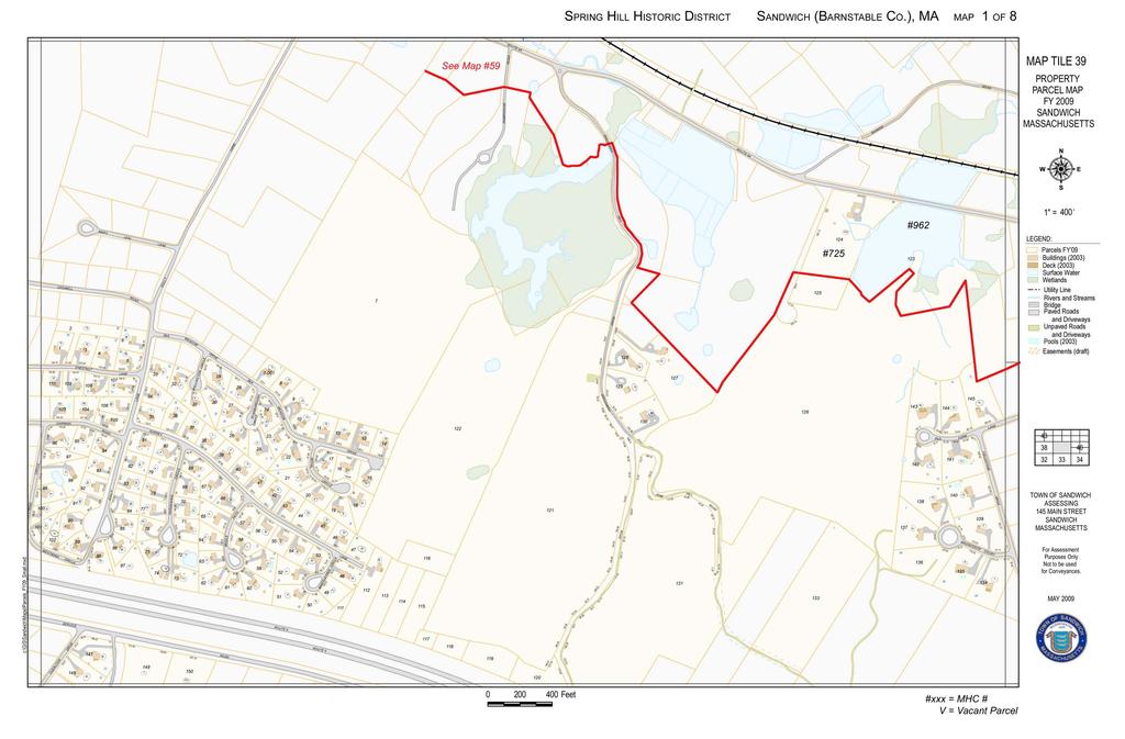
44
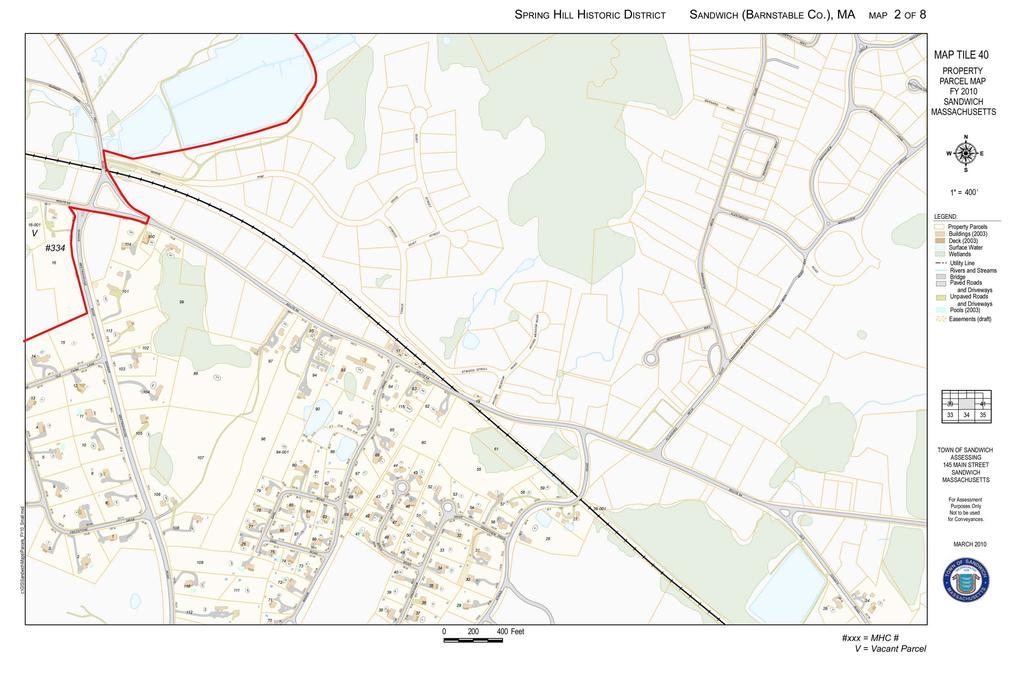
45
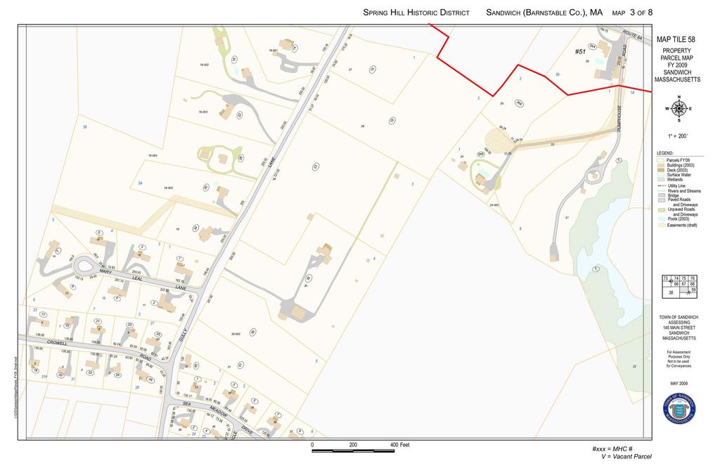
46

47
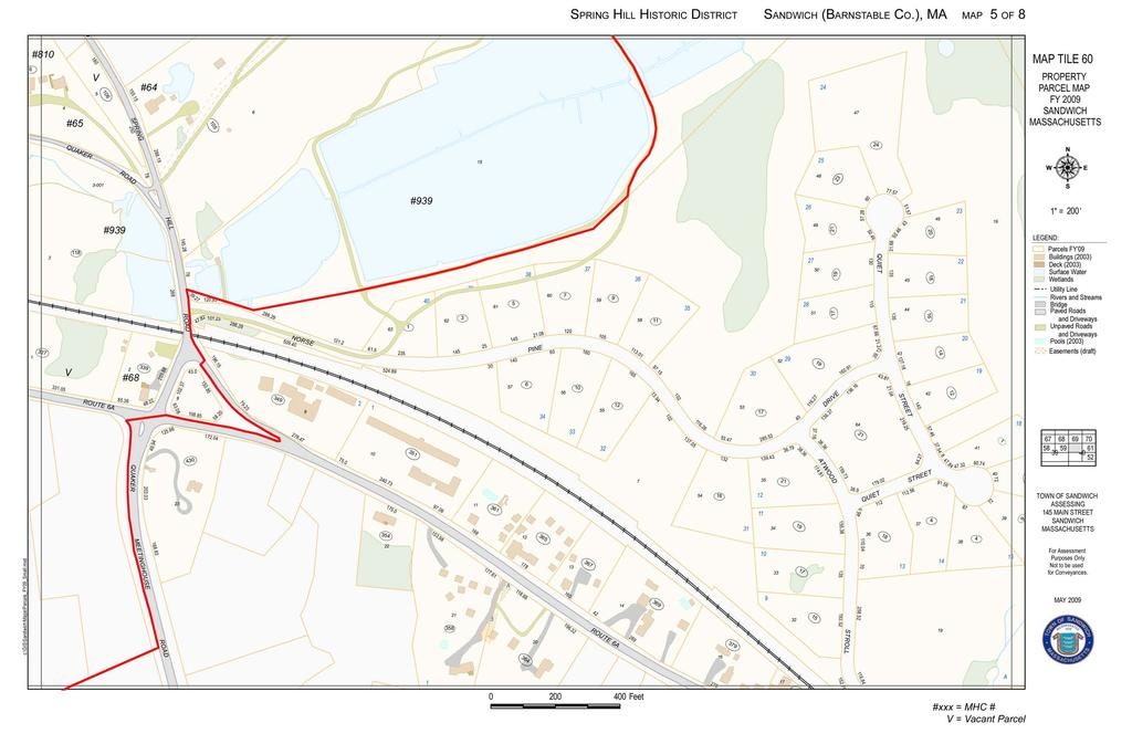
48
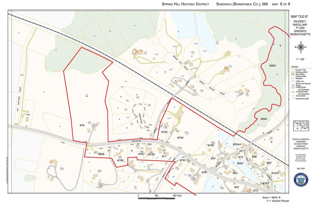
49
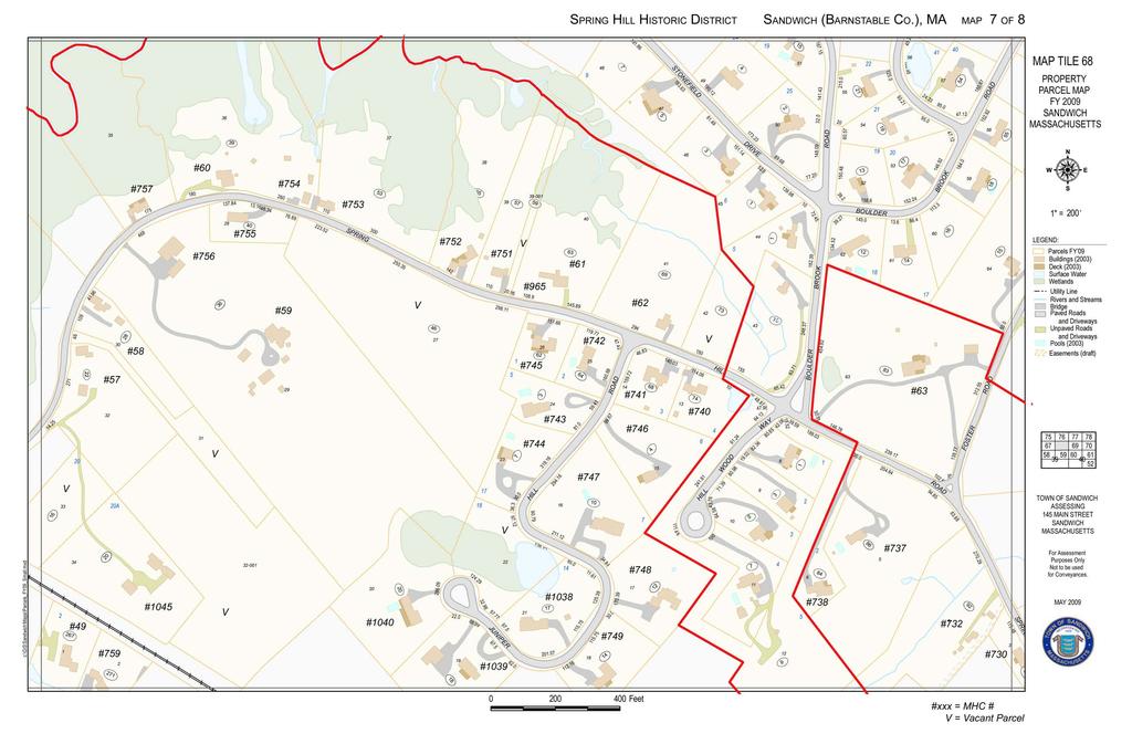
50
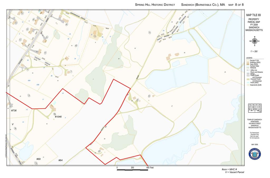
51
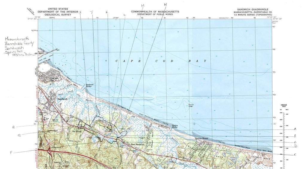
52
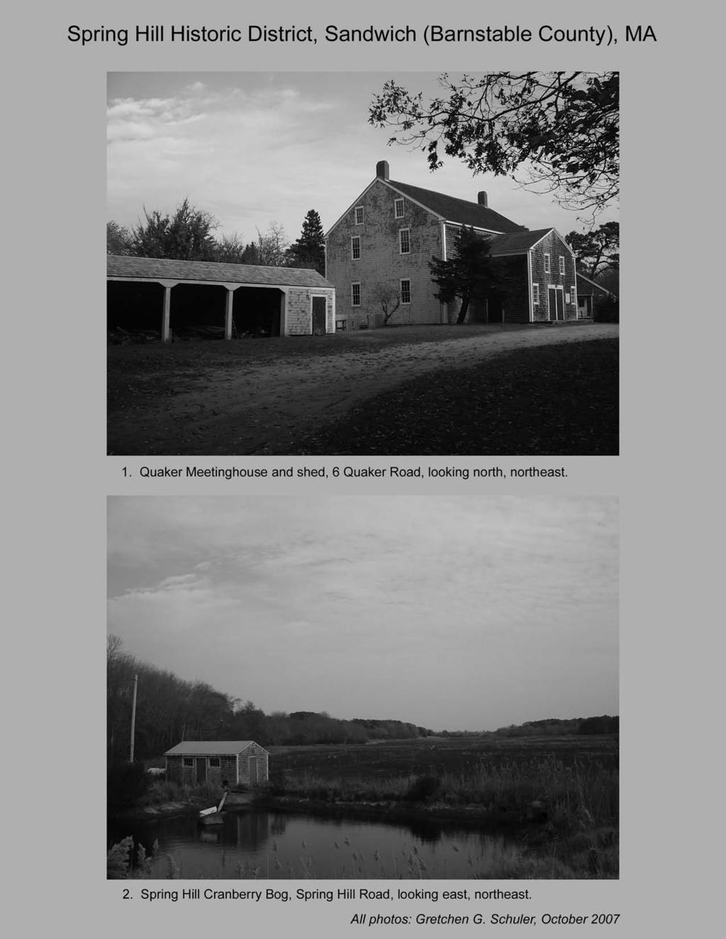
53
54
55
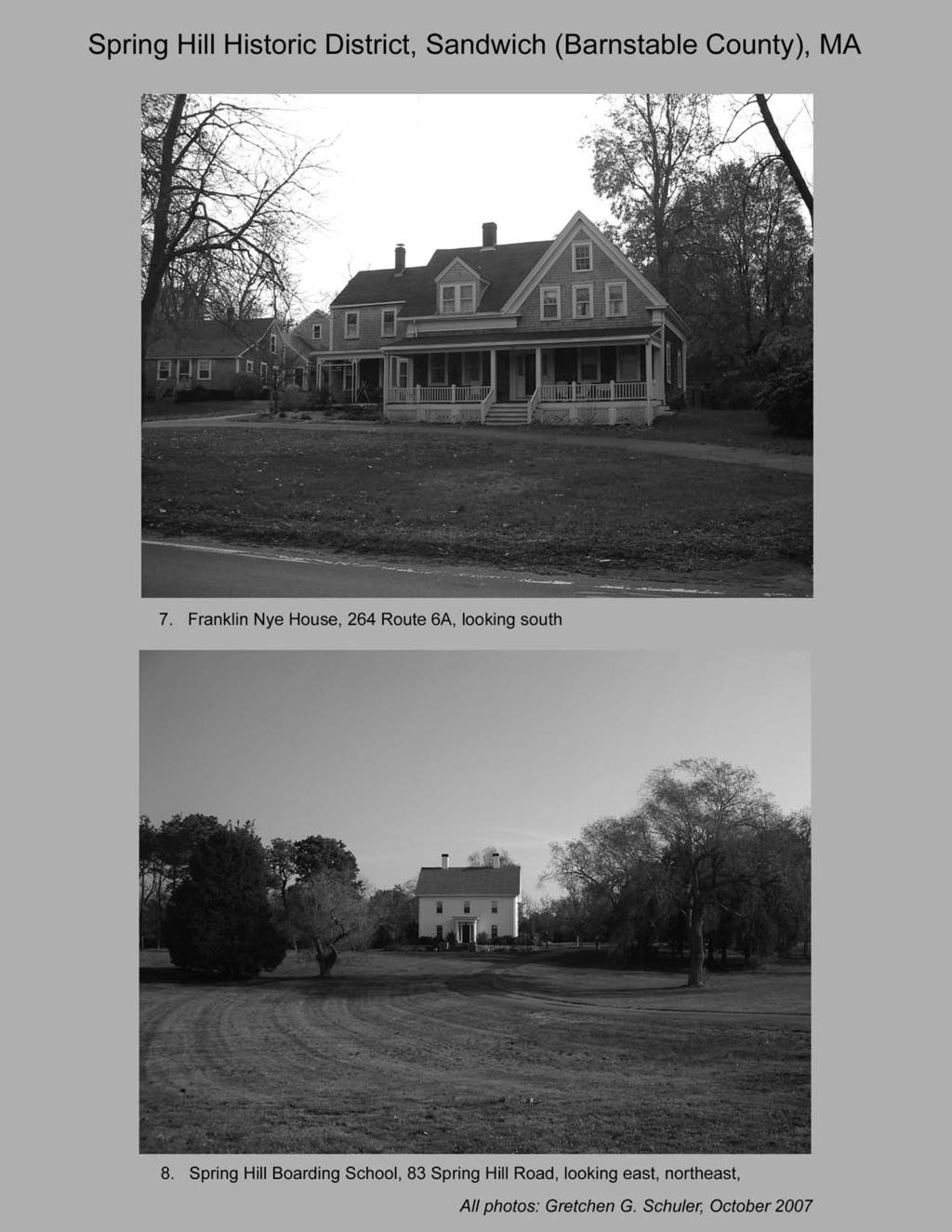
56
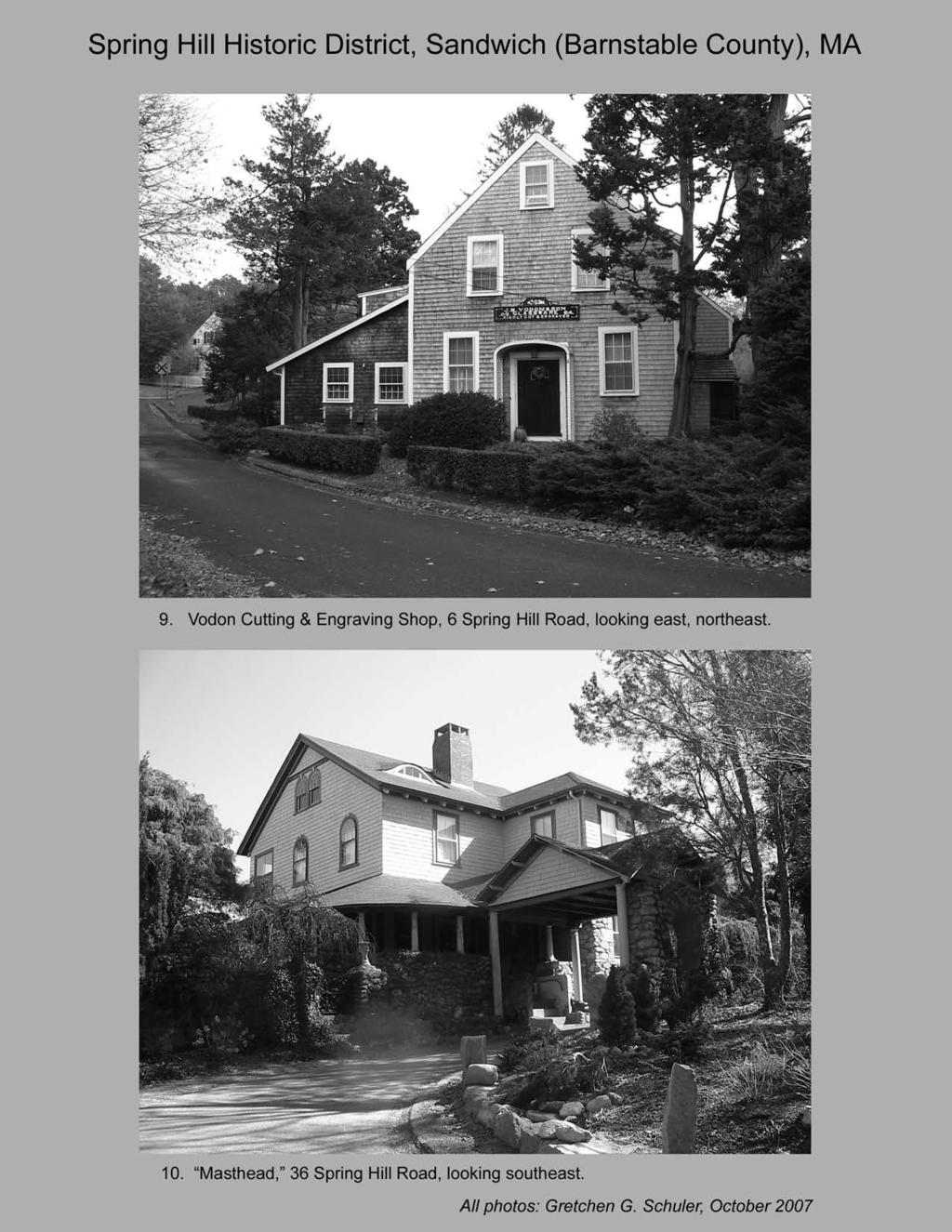
57
301 7½ Street SW
 301 7½ Street SW 104-0213-0072 Primary Resource Information: Single Dwelling, Stories 2.00, Style: Other, ca 1890 July 2006: This late-19th-century, 3-bay, 2-story, hip-roofed frame I-house features projecting
808 Cherry Avenue
 808 Cherry Avenue 104-0213-0059 Primary Resource Information: Single Dwelling, Stories 2.00, Style: Other, ca 1900 July 2006: This 2-story, 3-bay frame I-house features a central-front gable, a brick pier
Commonwealth of Massachusetts Massachusetts Historical Commission 220 Morrissey Boulevard, Boston, Massachusetts
 Inventory No: Historic Name: Common Name: Address: HRV.165 Blood, Joseph House Farnsworth, Jonathan - Beaman, Jonathan House 74 Poor Farm Rd City/Town: Village/Neighborhood: Local No: 9-17 Year Constructed:
1 Gildersleeve Wood (DHR # )
") GILDERSLEEVE WOOD 1 Gildersleeve Wood (DHR # 104-5092-0012) STREET ADDRESS: 1 Gildersleeve Wood MAP & PARCEL: 11-20 PRESENT ZONING: R-1U ORIGINAL OWNER: Lindsay Family ORIGINAL USE: PRESENT USE: PRESENT
GILDERSLEEVE WOOD 1 Gildersleeve Wood (DHR # 104-5092-0012) STREET ADDRESS: 1 Gildersleeve Wood MAP & PARCEL: 11-20 PRESENT ZONING: R-1U ORIGINAL OWNER: Lindsay Family ORIGINAL USE: PRESENT USE: PRESENT
Intensive Level Historic Resources Survey 5.0 ANNOTATED LIST OF PROPERTIES
 Intensive Level Historic Resources Survey 5.0 ANNOTATED LIST OF PROPERTIES CBCA PN 05-012A May 2009 Photo Location Description 10760 Bodine Road Date: 1811 Historic addition of side block to the rear;
 Page 1 Original Update HISTORICAL STRUCTURE FORM FLORIDA MASTER SITE FILE Consult Guide To Historical Structure Forms for detailed instructions Site # 8OR9844 Recorder # 26 Recorder Date 2/20/08 Site Name
Address 347 Whitney Street. East elevation, camera facing southwest.
 FORM B BUILDING Assessor s Number USGS Quad Area(s) Form Number MASSACHUSETTS HISTORICAL COMMISSION MASSACHUSETTS ARCHIVES BUILDING 220 MORRISSEY BOULEVARD BOSTON, MASSACHUSETTS 02125 Town Northborough
street & number: COUNTY ROUTE 3, HC-88, BOX 17 not for publication: N/A city/town: WHEELER vicinity: X state: WV county: WEBSTER code: 101 zip code:
 NPS Forn 10-900 OMB No. 10024-0018 (Oct. 1990) United States Department of the Interior National Park Service NATIONAL REGISTIR OF HISTORIC PLACES REGISTRATICN FCRX =========================================================---------=======
Town: Sharon Place (neighborhood or village): Sharon. ame of Area: Present Use: Date (month / year): July 2008
: Sharon. ame of Area: Present Use: Date (month / year): July 2008") FORM A - AREA MASSACHUSETTS HISTORICAL COMMISSION MASSACHUSETTS ARCHIVES BUILDING 220 MORRISSEY BOULEVARD BOSTON, MASSACHUSETTS 02125 Photograph Assessor s Sheets USGS Quad Area Letter Form Numbers in
FORM A - AREA MASSACHUSETTS HISTORICAL COMMISSION MASSACHUSETTS ARCHIVES BUILDING 220 MORRISSEY BOULEVARD BOSTON, MASSACHUSETTS 02125 Photograph Assessor s Sheets USGS Quad Area Letter Form Numbers in
Architectural Inventory Form
 OAHP1403 Rev. 9/98 COLORADO CULTURAL RESOURCE SURVEY Architectural Inventory Form Official eligibility determination (OAHP use only) Date Initials Determined Eligible- NR Determined Not Eligible- NR Determined
; * --.-.,., rj ; United States Department of the Interior \ ' '"] I National Park Service
![; * --.-.,., rj ; United States Department of the Interior \ ' '] I National Park Service](/thumbs/88/117765392.jpg "; * --.-.,., rj ; United States Department of the Interior \ ' '] I National Park Service") NPS Form 10-900 OMB No. 1024-0018 (Rev. 10-90) : / i' -_ :. - : ; ; * --.-.,., rj ; United States Department of the Interior \ ' '"] I National Park Service NATIONAL REGISTER OF HISTORIC PLACES REGISTRATION
NPS Form 10-900 OMB No. 1024-0018 (Rev. 10-90) : / i' -_ :. - : ; ; * --.-.,., rj ; United States Department of the Interior \ ' '"] I National Park Service NATIONAL REGISTER OF HISTORIC PLACES REGISTRATION
ADDENDUM. Chain of Title. Block C, Lot 8-9. Adrian I. Velthuis and Floyd T. Grant to Lottie Thompson
 Chain of Title Block C, Lot 8-9 NLP 5175:842 October 18, 1979 NLP 4979:58 October 5, 1977 NLP 4763:448 May 11, 1977 Adrian I. Velthuis and Floyd T. Grant to Lottie Thompson Gentlemens II Properties, Inc.,
SEE ATTACHED SHEET. Massachusetts Historical Commission 80 Boylston Street Boston, Massachusetts 02116
 FORMA - AREA Assessor's Sheets USGS Quad Area Letter Form Numbers in Area 153, 64-67, 1 I I I 124,57, 67, 91, I 76-79, 88-9d 650, 651, 9] 6-918, 1230-1241 West residential. commercial. industrial..."onstructiondates
National Register of Historic Places Registration Form
 NPS Form 10-900 OMB No. 10024-0018 (Oct. 1990) United States Department of the Interior National Register of Historic Places Registration Form 1. historic name South Charles Town Historic District other
500 Preston Place. Garages PRESENT USE: Garages PRESENT OWNER: Preston Court Limited Partnership ADDRESS:
 PRESTON PLACE 500 Preston Place STREET 500 Preston Place MAP & PARCEL: 5-116 Garages Garages PRESENT OWNER: Preston Court Limited Partnership 413 7 th Street NE Charlottesville, Va. 22902 DATE/ PERIOD:
NATIONAL REGISTER OF HISTORIC PLACES REGISTRATION FORM
 (Rev. 10-90) NPS Form 10-900 OMB No. 1024-0018 NATIONAL REGISTER OF HISTORIC PLACES REGISTRATION FORM This form is for use in nominating or requesting determinations for individual properties and districts.
ate: AR County: Pulaski Code: AR Zip Code: Noncontributing buildings sites structures objects Total
 Mims-Ereedlove-Priest-Weatherton House Name of Property Little Rock, AR County and State ~- -,s Form 10-900 'V. 8-86) OMB No. 1024-0018 United States Department of the Interior National Park Service NATIONAL
Maryland Historical Trust Inventory No. PG: 86A-026 Maryland Inventory of Historic Properties Form
 Inventory No. PG: 86A-026 Maryland Inventory of 1. Name of Property (indicate preferred name) historic other 2. Location street and number 12811 Croom Road not for publication city, town Naylor vicinity
United States Department of the Interior National Park Service NATIONAL REGISTER OF HISTORIC PLACES REGISTRATION FORM. Wilmoth, Bernard E.
 NPS Form 10-900 OMB No. 10024-0018 (Oct. 1990) United States Department of the Interior National Park Service NATIONAL REGISTER OF HISTORIC PLACES REGISTRATION FORM 1. Name of Property historic name: other
National Register of Historic Places Inventory Nomination Form
 NPS Form 10-900-a Exp. 10-31-84 Continuation sheet 4 5 item number 7 Page 45 NAME: Knight Estate LOCATION: 486 East Avenue,,--v..u^-^ OWNER: State of Rhode Island Department of Education Board of Regents
National Register of Historic Places Registration Form
 NPS Form 10-900 OMB No. 10024-0018 (Oct. 1990) Registration Form This form is for use in nominating or requesting determinations for individual properties and districts. See instructions in How to Complete
APPENDIX K: BUILT HERITAGE AND CULTURAL HERITAGE LANDSCAPES
 APPENDIX K: BUILT HERITAGE AND CULTURAL HERITAGE LANDSCAPES TABLE 1: Built Resources (BHR) and Cultural Heritage Landscapes (CHL) Within and Adjacent to the West Whitby Secondary Plan Area Site # 1. CHL
United States Department of the Interior National Park Service. Boundary Expansion Listed in National Register January 11, 2017
 NPS Form 10900-a (Rev. 8/2002) OMB No. 10240018 United States Department of the Interior National Park Service Boundary Expansion Listed in National Register January 11, 2017 National Register of Historic
National Register of Historic Places Registration Form
 NPS Form 10-900 OMB No. 10024-0018 (Oct. 1990) United States Department of the Interior National Park Service National Register of Historic Places Registration Form 1. Name of Property historic name Hickory
National Register of Historic Places Registration Form
 NPS Form 10-900 OMB No. 10024-0018 (Oct. 1990) Registration Form This form is for use in nominating or requesting determinations for individual properties and districts. See instructions in How to Complete
AH pp. I Ti. Nov 7 I) I I y
 I I y") ..------------------------------------------ ------------ - - -- - NPS Form 10-900 (Rev. 8-86) United States Department of the Interior ~a tional Park Service NATIONAL REGISTER OF HISTORIC PLACES REGISTRATION
..------------------------------------------ ------------ - - -- - NPS Form 10-900 (Rev. 8-86) United States Department of the Interior ~a tional Park Service NATIONAL REGISTER OF HISTORIC PLACES REGISTRATION
June 23, The Clayton Historic District is bounded by Mulberry Street, West Barnes Street, Mill Street, South Lombard Street and Blanche Street.
 June 23, 2010 This is the Clayton Historic District nomination to the National Register of Historic Places prepared by National Register Consultant Nancy Van Dolsen of Wilson, NC. The presentation was
NATIONAL REGISTER OF HISTORIC PLACES REGISTRATION FORM
 (Rev. 10-90) NPS Form 10-900 OMB No. 1024-0018 NATIONAL REGISTER OF HISTORIC PLACES REGISTRATION FORM This form is for use in nominating or requesting determinations for individual properties and districts.
National Register of Historic Places Registration Form
 NPS Form 10-900 (Rev. 01/2009) OMB No. 1024-0018 United States Department of the Interior National Park Service National Register of Historic Places Registration Form This form is for use in nominating
NATIONAL REGISTER OF HISTORIC PLACES REGISTRATION FORM
 NPS Form 10-900 OMB No. 1024-0018 (Rev. 10-90) United States Department of the Interior National Park Service NATIONAL REGISTER OF HISTORIC PLACES REGISTRATION FORM 1. Name of Property historic name Compton-Johnson
Proposed East Sanford Historic District DRAFT
 Proposed East Sanford Historic District DRAFT Inventory List The following inventory list provides basic information for all properties in the East Sanford Historic District. Included are each property
National Register of Historic Places Registration Form
 NPS Form 10-900 OMB No. 1024-0018 (Rev. 10-90) United States Department of the Interior National Park Service National Register of Historic Places Registration Form 1. Name of Property historic name Newcomer
Commonwealth of Massachusetts Massachusetts Historical Commission 220 Morrissey Boulevard, Boston, Massachusetts
 Inventory No: Historic Name: Common Name: Address: HRV.173 Rand, Jonathan House and Farm Taylor, William Jr. - Barnard, Ephraim House 44 Littleton County Rd City/Town: Village/Neighborhood: Local No: 23-20,21
Seaforth Walking Tour
 Seaforth Walking Tour 1: Victoria Park The land for Victoria Park was donated to the Town by Dr. William Gouinlock in 1875, (one year after Seaforth was officially incorporated). The bandshell was constructed
AHPP. ======================================================================== 3. Classi fication
 NPS Form 10-900 (Rev. 8-86) OMB No. 1024-0018 inited States Department of the Interior ational Park Service NATIONAL REGISTER OF HISTORIC PLACES REGISTRATION FORM I r' '- AHPP 1. Historic Name: Thornton
East and north elevations, camera facing west. Condition Good
 FORM B BUILDING MASSACHUSETTS HISTORICAL COMMISSION MASSACHUSETTS ARCHIVES BUILDING 220 MORRISSEY BOULEVARD BOSTON, MASSACHUSETTS 02125 Assessor s Number USGS Quad Area(s) Form Number Town Northborough
United States Department of the Interior National Park Service NATIONAL REGISTER OF HISTORIC PLACES REGISTRATION FORM
 NPS Form 10-900 (Rev. 8-86) OMB No. 1024-0018 United States Department of the Interior National Park Service NATIONAL REGISTER OF HISTORIC PLACES REGISTRATION FORM other name/site number: "Maple Shadows:"
Houses on the east side of River Street, camera facing northeast. Date (month/year) March 2009
 March 2009") FORM A - AREA MASSACHUSETTS HISTORICAL COMMISSION MASSACHUSETTS ARCHIVES BUILDING 220 MORRISSEY BOULEVARD BOSTON, MASSACHUSETTS 02125 Assessor s Sheets USGS Quad Area Letter Form Numbers in Area Shrewsbury
FORM A - AREA MASSACHUSETTS HISTORICAL COMMISSION MASSACHUSETTS ARCHIVES BUILDING 220 MORRISSEY BOULEVARD BOSTON, MASSACHUSETTS 02125 Assessor s Sheets USGS Quad Area Letter Form Numbers in Area Shrewsbury
NPS Form OMB No (Oct. 1990)
") NPS Form 10-900 OMB No. 10024-0018 (Oct. 1990) United States Department of the Interior National Park Service NATIONAL REGISTER OF HISTORIC PLACES REGISTRATION FORM 1. Name of Property historic name:_lost
NPS Form 10-900 OMB No. 10024-0018 (Oct. 1990) United States Department of the Interior National Park Service NATIONAL REGISTER OF HISTORIC PLACES REGISTRATION FORM 1. Name of Property historic name:_lost
Maryland Historical Trust Inventory No. PG: 75A-007 Maryland Inventory of Historic Properties Form
 Inventory No. PG: 75A-007 Maryland Inventory of 1. Name of Property (indicate preferred name) historic other 2. Location street and number 3101 Ritchie Road not for publication city, town Forestville vicinity
National Register of Historic Places Registration Form
 NPS Form 10-900 OMB No. 10024-0018 (Oct. 1990) United States Department of the Interior National Park Service National Register of Historic Places Registration Form 1. Name of Property historic name other
DESIGNATION REPORT KENNEDY-BAKER-WALKER-SHERRILL HOUSE (1849) 9320 KINGSTON PIKE (CLT ) KNOXVILLE, TENNESSEE July 12, 2007
 9320 KINGSTON PIKE (CLT ) KNOXVILLE, TENNESSEE July 12, 2007") DESIGNATION REPORT KENNEDY-BAKER-WALKER-SHERRILL HOUSE (1849) 9320 KINGSTON PIKE (CLT 132-027) KNOXVILLE, TENNESSEE July 12, 2007 Description The Kennedy-Baker-Walker-Sherrill House is located on the south
DESIGNATION REPORT KENNEDY-BAKER-WALKER-SHERRILL HOUSE (1849) 9320 KINGSTON PIKE (CLT 132-027) KNOXVILLE, TENNESSEE July 12, 2007 Description The Kennedy-Baker-Walker-Sherrill House is located on the south
National Register of Historic Places Registration Form
 NPS Form 10-900 OMB No. 10024-0018 (Oct. 1990) Registration Form This form is for use in nominating or requesting determinations for individual properties and districts. See instructions in How to Complete
SURVEY OF PUBLIC HOUSES WESTON TURVILLE
 BUCKINGHAMSHIRE ARCHAEOLOGICAL SOCIETY HISTORIC BUILDINGS GROUP SURVEY OF PUBLIC HOUSES IN THE PARISH OF WESTON TURVILLE BUCKINGHAMSHIRE A record of extant buildings that are currently or were formerly
 ~. ',. ( NPS Form 10-900 (Rev. 8-86) NR I ;s+eca Cf/ S /q~ OMB No. 1024-0018 United States Department of the Interior National Park Service NATIONAL REGISTER OF HISTORIC PLACES REGISTRATION FORM ------------------------------------------------------------------------
AHPP. LISTED ========================================================================
 NPS Form 10-900 (Rev. 8-86) Jnited States Department of the Interior ational Park Service OMB No. 1024-0018 LISTED NATIONAL REGISTER OF HISTORIC PLACES REGISTRATION FORM AHPP. 1. Historic Name: Bush-Dubisson
Agriculture; Architecture; Community Planning
 Inventory No: Historic Name: SBR.Q Bemis - LaurEdo Farm Common Name: Address: City/Town: Village/Neighborhood: Local No: Year Constructed: Architect(s): Architectural Style(s): Use(s): Significance: Agricultural;
STATE OF IOWA. Historical and Architectural Survey for 2008 Flood Projects in Vinton, Benton County
 STATE OF IOWA CHESTER J. CULVER GOVERNOR PATTY JUDGE LT. GOVERNOR DEPARTMENT OF PUBLIC DEFENSE IOWA HOMELAND SECURITY AND EMERGENCY MANAGEMENT DIVISION DAVID L. MILLER, ADMINISTRATOR Historical and Architectural
National Register of Historic Places Registration Form
 NPS Form 10-900 OMB No. 10024-0018 (Oct. 1990) Registration Form This form is for use in nominating or requesting determinations for individual properties and districts. See instructions in How to Complete
Appendix E Historic Property Inventory Forms
 Appendix E Historic Property Inventory Forms TECHNICAL MEMORANDUM Sound Transit Federal Way Link Extension WISAARD Survey Entries PREPARED FOR: COPY TO: PREPARED BY: Sound Transit Alisa Swank/ CH2M MaryNell
Abandoned or Vacant; Agricultural; Camp; Other Residential Agriculture; Archaeology, Historic; Architecture; Politics Government; Social History
 Inventory No: Historic Name: HRV.G Civilian Conservation Camp Common Name: Address: City/Town: Village/Neighborhood: Local No: 13-7.01 Year Constructed: Architect(s): Architectural Style(s): Use(s): Significance:
APPENDIX A HISTORIC RESOURCES INVENTORY FEATURE LOCATION OWNERSHIP DESCRIPTION
 APPENDIX A HISTORIC RESOURCES INVENTORY FEATURE LOCATION OWNERSHIP DESCRIPTION Map 1 - Sea Ranch North Del Mar West of Highway 1 This gable roof board and batten in The Sea Ranch cottage is one of the
National Register of Historic Places Registration Form
 NPS Form 10-900 OMB No. 1024-0018 (Expires 5/31/2012) United States Department of the Interior National Register Listed National Park Service May 1, 2012 National Register of Historic Places Registration
NPS Form OMB No Exp Status occupied X unoccupied work in progress Accessible yes: restricted yes: unrestricted _5Lno
 NPS Form 10-900 OMB No. 1024-0018 Exp. 10-31-84 United States Department of the Interior National Park Service National Register of Historic Places Inventory Nomination Form See instructions in How to
NE¼ of NE¼ of NE¼ of NE¼ of section Roof configuration (enter one): Gabled Roof / Front Gabled Roof
: Gabled Roof / Front Gabled Roof") OAHP1403 Rev. 9/98 COLORADO CULTURAL RESOURCE SURVEY Official Eligibility Determination (OAHP use only) Date Initials Determined Eligible - National Register Architectural Inventory Form Determined Not
OAHP1403 Rev. 9/98 COLORADO CULTURAL RESOURCE SURVEY Official Eligibility Determination (OAHP use only) Date Initials Determined Eligible - National Register Architectural Inventory Form Determined Not
National Register of Historic Places Registration Form
 NPS Form 10-900 OMB No. 10024-0018 (Oct. 1990) Registration Form This form is for use in nominating or requesting determinations for individual properties and districts. See instructions in How to Complete
National Register of Historic Places Registration Form
 NPS Form 10-900 OMB No. 1024-0018 (Rev. 10-90) United States Department of the Interior National Park Service National Register of Historic Places Registration Form 1. Name of Property historic name Strode-Morrison-Tabler
county Lonoke code 085 zip code
 ~~~~~~~~~~~ AR NPS Form I 0-900 (Oct. 1990) United States Department of the Interior National Park Service National Register of Historic Places egistration Form w-l.3-1 / OMB No. 10024-0018 This form is
National Register of Historic Places Registration Form
 NPS Form 10-900 OMB No. 1024-0018 (Rev. 10-90) United States Department of the Interior National Park Service National Register of Historic Places Registration Form 1. Name of Property historic name Evans,
United States Department of the Interior National Park Service NATIONAL REGISTER OF HISTORIC PLACES REGISTRATION FORM
 NPS Form 10-900 (Oct. 1990) OMB NO. 10024-0018 United States Department of the Interior National Park Service NATIONAL REGISTER OF HISTORIC PLACES REGISTRATION FORM As the designated authority under the
D not for publication D vicinity
 NPS Fonn I 0-900 (Oct. 1990) OMB No. 10024-0018 United States Department of the Interior National Park Service National Register of Historic Places Registration Form This fom1 is for use in nominating
Appendix D Reevaluation of Structures on Bock House Property
 Appendix D Reevaluation of Structures on Bock House Property Page 1 Original Update HISTORICAL STRUCTURE FORM FLORIDA MASTER SITE FILE Consult Guide To Historical Structure Forms for detailed instructions
Hwy Retaining Wall/ Sea Wall. Not Eligible, see Statement of Significance Also member of listed NR district: Mantorville Historic District
 Historic Name CS # 2007 Other Name SHPO Inv # Location E and W sides of TH 57 between 6th St and 7th St Hwy District Reference City/Township County Mantorville, City of Dodge Acres Twp Rng Sec 107N 16W
Maryland Historical Trust Inventory No. PG: 86A-003 Maryland Inventory of Historic Properties Form
 Inventory No. PG: 86A-003 Maryland Inventory of 1. Name of Property (indicate preferred name) historic other 2. Location street and number 12005 Duley Station Road not for publication city, town Upper
April 28, Reuben McKnight Historic Preservation Officer 747 Market Street, Suite 1036 Tacoma, WA Dear Mr. McKnight:
 April 28, 2016 Reuben McKnight Historic Preservation Officer 747 Market Street, Suite 1036 Tacoma, WA 98402 Dear Mr. McKnight: I am delighted to inform you that the Buckley s Addition Historic District
Maryland Historical Trust Inventory No. PG: 81B-008 Maryland Inventory of Historic Properties Form
 Maryland Historical Trust Inventory No. PG: 81B-008 Maryland Inventory of 1. Name of Property (indicate preferred name) historic other 2. Location Dyson Farmhouse (preferred) street and number 13010 Piscataway
I I I Marlborough I
 FORM E - BURIAL GROUND Assessor's number USGS Quad I 60-35 I I I Arca(s) Fonl1 Number I - Town. ",-" Place (neighborhood or village) _ Wilson Street Name Ownership: [] private [X] public Approximate number
APPENDIX D Existing Inventory of Cary's Historic Resources
 APPENDIX D Existing Inventory of Cary's Historic Resources The word inventory has a variety of meanings and connotations. In classic historic preservation methodology, it is the first of a three-step process:
Signature of certifying official/title. New York State Office of Parks, Recreation & Historic Preservation State or Federal agency and bureau
 NPS Form 10-900 OMB No. 10024-0018 (Oct. 1990) Registration Form This form is for use in nominating or requesting determinations for individual properties and districts. See instructions in How to Complete
National Register of Historic Places Registration Form
 National Park Service National Register of Historic Places Registration Form This form is for use in nominating or requesting determinations for individual properties and districts. See instructions in
Heritage Survey: Stellenbosch Rural Areas
 Heritage Survey: Stellenbosch Rural Areas by and Stewart Harris - June 2004 Sub Area Name Catalogue Number Jonkershoek 02.06 Property Name Glenconner, Jonkershoek, Stellenbosch District Farm Number 345/7
HB/10/06/003 Camus House, 46 Lisky Rd, Strabane. Foyle Valley
 Asset Ref No. Heritage Type House, Gates, Outbuildings, Walling Including Around Flax Drying Green. Built Post-Medieval house Location OS 6-inch map sheet Townland Parish LCA Foyle Valley ITM Coordinates
ATTACHMENT C ARLINGTON COUNTY REGISTER OF HISTORIC PLACES HISTORIC DISTRICT DESIGNATION FORM
 1. NAME OF PROPERTY ARLINGTON COUNTY REGISTER OF HISTORIC PLACES HISTORIC DISTRICT DESIGNATION FORM Historic Name: Other names: Reevesland Torreyson Farm 2. LOCATION OF PROPERTY Street and Number: 400
MEDIA ADVISORY. FOR IMMEDIATE RELEASE November 12, 2012
 MEDIA ADVISORY FOR IMMEDIATE RELEASE November 12, 2012 Niagara-on-the-Lake On Monday, November 19, 2012, the Lord Mayor and members of the Town s Municipal Heritage Committee and War of 1812 Bicentennial
NPS Form OMB No (Rev ) U. S. Department of the Interior Name of Property: Hungry Mother State Park Historic District
 U. S. Department of the Interior Name of Property: Hungry Mother State Park Historic District") NPS Form 10-900 OMB No. 1024-4018 (Rev. 10-90) U. S. Department of the Interior Name of Property: Location: 5. Classification Ownership of Property (Check as many boxes as apply) Category of Property (Check
NPS Form 10-900 OMB No. 1024-4018 (Rev. 10-90) U. S. Department of the Interior Name of Property: Location: 5. Classification Ownership of Property (Check as many boxes as apply) Category of Property (Check
Commonwealth of Massachusetts Massachusetts Historical Commission 220 Morrissey Boulevard, Boston, Massachusetts
 Inventory No: Historic Name: Common Name: Address: NWB.3010 Colonial Beacon Oil Company Shed Blue Frontier Yacht Services Office 115 Water St City/Town: Newburyport Village/Neighborhood: Local No: 20-10
FOUNDATIONS OF ARCHAEOLOGY A WALK IN VERNDITCH CHASE
 FOUNDATIONS OF ARCHAEOLOGY A WALK IN VERNDITCH CHASE 1. A Tale of two Long Barrows Long barrows were constructed as earthen or drystone mounds with flanking ditches and acted as funerary monuments during
United States Department of the Interior National Park Service NATIONAL REGISTER OF HISTORIC PLACES REGISTRATION FORM
 NPS Form 10-900 (Oct. 1990) OMB No. 10024-0018 United States Department of the Interior National Park Service NATIONAL REGISTER OF HISTORIC PLACES REGISTRATION FORM 1. DR JOHN C. IRONS RESIDENCE hlstoric
CELEBRATE WEST GREENWICH GEOCACHING THROUGHOUT WEST GREENWICH
 CELEBRATE WEST GREENWICH GEOCACHING THROUGHOUT WEST GREENWICH The West Greenwich Land Trust (WGLT) is sponsoring Celebrate West Greenwich, an event designed to celebrate the beauty and history of scenic
National Register of Historic Places Registration Form
 National Park Service National Register of Historic Places Registration Form This form is for use in nominating or requesting determinations for individual properties and districts. See instructions in
National Register of Historic Places Registration Form
 NPS Form 10-900 OMB No. 1024-0018 (Expires 5/31/2012) National Register of Historic Places Registration Form This form is for use in nominating or requesting determinations for individual properties and
Cross Street Walking Tour
 Cross Street Walking Tour 1. 33 King Street West: Collins Hotel: 1840 s This impressive building was constructed in 1841 by Bernard Collins. The gallery and Greek style portico were built in the 1850 s
CHRONOLOGY & DEVELOPMENT BOUDINOT-SOUTHARD PROPERTY BASKING RIDGE, NJ OF THE
 CHRONOLOGY & DEVELOPMENT OF THE BOUDINOT-SOUTHARD PROPERTY BASKING RIDGE, NJ Elias Boudinot 1740 Elias Boudinot born May 2 in Philadelphia, where his family was a neighbor of Benjamin Franklin. 1760 Boudinot
THE CORPORATION OF THE TOWN OF NIAGARA-ON-THE-LAKE. BY-LAW NO (214 Four Mile Creek Road)
") THE CORPORATION OF THE TOWN OF NIAGARA-ON-THE-LAKE BY-LAW NO. 4807-15 (214 Four Mile Creek Road) A BY-LAW TO DESIGNATE THE PROPERTY KNOWN MUNICIPALLY AS WOODBOURNE, 214 FOUR MILE CREEK ROAD, IN THE TOWN
THE CORPORATION OF THE TOWN OF NIAGARA-ON-THE-LAKE BY-LAW NO. 4807-15 (214 Four Mile Creek Road) A BY-LAW TO DESIGNATE THE PROPERTY KNOWN MUNICIPALLY AS WOODBOURNE, 214 FOUR MILE CREEK ROAD, IN THE TOWN
State Level Historic Documentation Report. John Blue Bridge Hampshire County
 State Level Historic Documentation Report State Project No. S314-28-22.27 Federal Project No. BR-0028(058)D John Blue Bridge Hampshire County Prepared by: Randy Epperly, Historian Department of Transportation
National Register of Historic Places Registration Form
 PS Form 10-900 OMB No. 10024-0018 (Oct. 1990) United States Department of the Interior National Park Service Registration Form This form is for use in nominating or requesting determinations for individual
HENNIGAN PLACE. This photograph is circa November Name, address, and telephone number of the present owner and occupant of the property:
 HENNIGAN PLACE This report was written on November 7, 1979 This photograph is circa November 2006. 1. Name and location of the property: The property known as the Hennigan Place is located at 3503 Tilley
Change dormers and main entry on the river side of the house. Site: 43 Riverbank Road, Block 10 Lot 3
 City of Burlington Historic Preservation Commission Meeting Minutes: December 2, 2015 The City of Burlington Historic Preservation Commission held its regular monthly meeting on Wednesday, December 2,
4. Historic Resources
 4. Historic Resources Introduction Seabrook was historically a rural community of small villages, agricultural areas, extensive salt marshes and a major beach area. The boundaries of the present town were
PROJECT: Rehabilitate Historic Bathhouses for Adaptive Use
 LOCATION: Hot Springs National Park, Hot Springs Arkansas SIZE: Approximately 105,000 sf among six buildings DATE: 2003-present ROLE: Project Manager for Historic Structure Reports, pre-design through
National Register of Historic Places Continuation Sheet
 Section number N/A Page 1 Proposed Amendment to Wichita, Sedgwick County, Kansas The owner of the building at 141 S. Rock Island Avenue requests amendment to the boundaries of the East Douglas Historic
National Register of Historic Places Continuation Sheet
 Section Number _7 Page 1 Kents Corner Historic District Summary This National Register nomination reflects a resurvey and boundary increase to the original Kents Corner Historic District and the original
MINNESOTA HISTORIC.PROPERTIES INVENTORY FORM. Yes_ No X Restricted
 HISTORIC NAME: CURRENT NAME: LEGAL DESC.: MINNESOTA HISTORIC.PROPERTIES INVENTORY FORM Hartley Sugar Camp W % of Gov't. Lot 3 and T55, R24, Sec. 9 COUNTY: Itasca CITY/TWP.: Trout Lake Twp. ADDRESS: of
Maryland Historical Trust Inventory No. PG: Maryland Inventory of Historic Properties Form
 Inventory No. PG: 62-012 Maryland Inventory of 1. Name of Property (indicate preferred name) historic other 2. Location street and number 11205 Old Baltimore Pike not for publication city, town Beltsville
N/A not for publication city or town : Hillsboro - X vicinity state: West Virginia code: WV countv: Pocahontas code: 075 zip code: 24946
 United States Department of the Interior National Park Service historic name : other nameslsite number : NIA. -.- 2. Location street & number : HC 64. Box 147loff County Road 3 1 on Kyle Beard Road N/A
FLAGLER WORKER S HOUSE FORT DALLAS PARK S.E. 4 STREET
 FLAGLER WORKER S HOUSE FORT DALLAS PARK 60-64 S.E. 4 STREET Designation Report City of Miami REPORT OF THE CITY OF MIAMI PLANNING DEPARTMENT TO THE HERITAGE CONSERVATION BOARD ON THE POTENTIAL DESIGNATION
National Register of Historic Places Registration Form
 NPS Form 10-900 OMB No. 1024-0018 (Expires 5/31/2012) United States Department of the Interior National Register Listed National Park Service May 1, 2012 National Register of Historic Places Registration
HISTORIC SITE FORM HISTORIC SITES INVENTORY
 HISTORIC SITE FORM HISTORIC SITES INVENTORY 1 IDENTIFICATION Name of Property: House at 569 Park Avenue PARK CITY MUNICIPAL CORPORATION (10-08) Address: 569 Park Avenue City, County: Park City, Summit
BLOCK LOT QUAD. _ CITY: Houston _ UTM: STYLE: THEME:
 (/I NAME. ADDRESS: 1537 Tulsne COUNTY CITY QUAD ARCHITECT/BUILDER: nwnifr- Elroy Kuehn etax 1510 Ashland Houston^ TX 77008 BLOCK LOT _ COUNTY:. Harri _ CITY: Houston _ UTM: STYLE: THEME: s PERIOD:. nf«;rriptinv-
Architectural Inventory Form
 COLORADO CULTURAL RESOURCE SURVEY Page 1 of 3 Official Eligibility Determination (OAHP use only) Rev. 9/98 OAHP1403 Date Initials Determined Eligible National Register Determined Not Eligible National