Origins June 2005 Update:
|
|
|
- Percival Powell
- 5 years ago
- Views:
Transcription

1
2 Downtown Freeways Building freeways through central business districts was a costly and difficult task. Numerous freeways converged in a small area, requiring a large number of freeway-to-freeway interchanges. Extensive connections into downtown streets were necessary. The street networks around downtown would need to remain intact where they crossed freeways. Traffic volumes were high, and right-of-way was often limited. Solving these problems necessitated the most complex designs in urban freeway systems. The designers of Houston s downtown interchange complex faced these challenges, but they had certain advantages working in their favor. Houston s downtown environment was more conducive to freeway construction than most other cities. Outside the relatively compact core of downtown, there were practically no barriers to the construction of the freeway system. Better yet, there were low-density zones around the periphery of downtown, slum areas that invited freeways, a natural freeway corridor on the northwest side of downtown, and a city street network capable of handling large traffic volumes coming off the freeways. The result: Houston boasts one of the nation s most extensive and impressive downtown interchange complexes. Downtown Houston and the extensive freeway system turned out to be a match made in concrete and steel heaven. As of the late 1960s, downtown Houston was a rather unimpressive collection of mid-rise office structures, many quite old. Around the same time, the freeway system into downtown was substantially completed, providing superb accessibility. By the early 1980s downtown Houston had one of the nation s more impressive skylines. The elevated freeways skirting the edges of downtown showcase the skyline to passing motorists, providing a unique driving experience. (Opposite page) Mega-merge: The US 59-SH 288 interchange south of downtown is the widest section of downtown freeway. (Photo: May 2003)
3 118 Houston Freeways Origins As Houston s freeway system was taking shape in the 1940s, the focus point was downtown. The Texas Transportation Commission approved the Gulf Freeway in October 1943, with the original planned alignment stopping just short of downtown. In May 1945, the commission authorized alignment studies for US 59 from Buffalo Bayou northward and US 75 (now IH 45) along the west and south sides of downtown. In October 1946, the commission approved the addition of the US 90 (now IH 10) freeway across Houston, which was planned to pass just north of the central business district. At this point, Houston s freeway system consisted of five spokes converging on downtown, and the miniloop around the central business district had three of its four sides in the development stage. On September 30, 1948, the Gulf Freeway was opened just southeast of downtown Houston. The freeway s terminus into downtown was one of its more important design features. The freeway was directly connected to four high-capacity downtown streets two inbound one-way streets and two outbound one-way streets. The head of the TxDOT Houston Urban Project Office, W. J. Van London, called the transition zone to the freeway the loading platform. In November 1948, American City magazine stated that the freeway terminus resembles the mouth of a stream with its delta widening out to receive the slower-moving waters. The Gulf Freeway terminus set the standard for all other freeways entering downtown, with each freeway distributing traffic onto several downtown streets. In 1950 Van London and city officials were working to define the details of the downtown interchange complex, including exact alignments. At the time, 10 freeway spokes were envisioned for downtown Houston. The early vision included the 7 existing spokes in 2003 and Memorial Parkway, the unbuilt Harrisburg Freeway, and a route between the South and Gulf Freeways that later became the Alvin Freeway. Double-deck structures were studied, particularly for IH 10 north of downtown and some of the distribution structures into downtown. However, no double-deck structures were ultimately used. 1 Formulation of the downtown freeway plan was part of a comprehensive local effort to define Houston s overall freeway system. In April 1953, the Texas Transportation Commission formally approved the US 59 freeway on the east side of downtown, closing the freeway loop around downtown. Houston s first comprehensive freeway plan was ready for presentation to the Texas Transportation Commission in July The initial version of the plan June 2005 Update: The US 59/IH-10 interchange opened to regular traffic in October 2003 and was fully completed in early 2004 when the HOV lane opened. Construction was accelerated to complete it in advance of the 2004 Superbowl.

4 Downtown Freeways 119 The double deck that wasn t: Early concepts for downtown Houston freeways included possible double-deck freeways, such as this one that was contemplated for IH 10 on the north side of downtown. Although downtown Houston has many elevated freeways, no double-deck structures were built. IH 10 north of downtown, opened on May 17, 1972, was the next-to-last segment of originally-planned downtown freeway main lanes to open. (Photo: TxDOT) for the downtown interchange complex was slightly different from the final plan. In the 1953 plan, the Southwest Freeway followed the present-day route of Spur 527 all the way to IH 45 on the southwest side of downtown (see plan map, page 13). 2 In 1954 the freeway master plan was adjusted, bringing the downtown interchange complex to its near final general configuration. In the final plan, Spur 527 was strictly a part of the Southwest Freeway distribution system into downtown streets. With the final and official plan in place, it was clear that Houston s downtown freeway complex would be extensive. It featured two major multiplex freeway interchanges, where two freeways would run parallel to each other one on the north side of downtown with IH 45 and IH 10, and one on the south side of downtown with US 59 and SH 288. There would be two stack-type interchanges, one at US 59 and IH 45, and one at US 59 and IH 10. IH 45 on the west side of downtown would feature an elevated complex of ramps connecting to downtown and the parkways along Buffalo Bayou. All downtown freeways would be elevated above grade or depressed below grade. There were still many details to be worked out. In May 1957, city of Houston planning director Ralph Ellifrit and TxDOT Houston Urban Project Office head A. C. Kyser met in Kyser s office to plan details of the downtown freeways. Two days later Ellifrit summarized their plans in a letter titled Central Interchange Study. The letter detailed how the existing downtown street system would be fully integrated into the freeway system by assigning at least four feeder streets to each radial freeway. To increase the merging distance between the US 59-SH 288 interchange and nearby US 59-IH 45 interchange, Ellifrit recommended a southward shift of the US 59-SH 288 interchange. Most of the ideas contemplated in the May 1957 meeting, including the southward shift of the US 59-SH 288 interchange, would become part of the final plan. Houston s downtown freeways were designated as the Houston Central Interchange. 3 In August 1960, the Texas Transportation Commission closed the last remaining gap in the downtown freeway system by formally approving US 59 between Spur 527 and IH 45. Part of this newly approved section would become the widest and most impressive freeway segment in the downtown area. 4 In 1963 the overall plan for the downtown Houston freeway system was finalized. There would subsequently be only three significant changes to this plan. First, the interchange at the intersection of the planned Harrisburg Freeway and US 59 would never be built, since the Harris-

5 120 Houston Freeways Clearing the path: Right-of-way clearance for present-day IH 45 on the west side of downtown was complete when this photo was taken on August 3, This section of freeway was the first to be constructed in downtown Houston. The parallel rows of buildings in the upper right of the photo are part of the Allen Parkway Village housing project. (Photo: Squire Haskins Photography, Dallas) burg Freeway was later cancelled. Second, a third freeway multiplex would be added southeast of downtown along IH 45 where SH 35, the planned Alvin Freeway, merged with IH 45. And third, the Eastex Freeway interchange complex on the northeast side of downtown, including the interchange with IH 10, would be substantially expanded in work that began in the late 1990s. 5 Clearing the Way Most of the right-of-way clearance for Houston s downtown freeways consisted of residential structures, with some areas of low grade commercial structures and light industry also affected. The older, decayed neighborhoods around downtown Houston worked in favor of the freeway builders. Although slum clearance was much less pervasive in Houston than it was in older eastern cities, two of Houston s best examples of slum clearance occurred immediately adjacent to downtown freeways. The Allen Parkway Village project, originally known as San Felipe Courts, was opened in 1942 and IH 45 was constructed along its eastern edge in * The Clayton Homes housing project was built just northeast of * Allen Parkway Village became the focus of a long-running, highly contentious controversy when the city of Houston began efforts to demolish it in the mid-1970s. In early 1996 a compromise plan was approved, and 677 of the 963 units were demolished in 1996 and The controversy was not related to the adjacent IH 45 freeway.


6 Construction begins: This 1954 photo shows the first construction on the downtown Houston freeway system the first phase of IH 45 on the west side of downtown. This view looks east along Allen Parkway. (Photo: Greater Houston Partnership) The first downtown freeway: This short section of IH 45 on the west side of downtown opened on December 12, This photo was taken within two years of the opening and looks southeast, similar to the perspective of the photo on the opposite page. (Photo: TxDOT)
7 122 Houston Freeways Few obstacles to freeways: Downtown Houston presented few obstacles to freeway construction. The map above shows the locations of the freeway sections that presented some difficulty. downtown in 1952, and in 1958 US 59 was constructed alongside the property. The largest right-of-way clearance for the downtown freeway system occurred in the late 1960s on the south side of downtown, where a very wide corridor was required for the US 59-SH 288 interchange. There were generally no objections to the displacement of residences in the neighborhoods around downtown. Another possible roadblock to freeway construction was the parkland along Buffalo Bayou just west of downtown, adjacent to the Houston Civic Center. A web of elevated structures and connection ramps was envisioned for IH 45 through that section of downtown. In a 1979 interview, Ralph Ellifrit remarked that there was considerable discussion about building a freeway at that location, but there was just no way to build the downtown freeway system without routing the freeway there. Time would prove that the freeway would not have a negative impact on the park or downtown civic center. 6 On the east side of downtown, US 59 needed to pass over a rail yard which included Union Station, one of the city s railway stations for passenger service. In 1953 the city of Houston began efforts to relocate Union Station, which was controlled by the Houston Belt and Terminal Railroad, to Southern Pacific Railroad s Grand Central Station. City planners envisioned connecting the Eastex Freeway (US 59 north of downtown) into the street immediately adjacent to the elevated structure, Chartres, and the three parallel streets to the west, using a distribution system similar to the loading platform where the Gulf Freeway distributed traffic into downtown. However, Union Station blocked three of the four streets which would connect to the freeway, making the distribution system impractical. Efforts to relocate the station continued through the mid-1950s, with negotiations breaking down by In 1960 the matter needed to be resolved so construction could move forward. On November 2, 1960, officials from the city of Houston, TxDOT, and the railroad reached an agreement after a one-and-a-half hour session. The railroad agreed to relocate some tracks to provide space for the columns of the US 59 elevated structure, but the Union Station itself would stay. As a result, the Eastex Freeway would lack a full distribution system into downtown in its original construction, since the railroad station blocked the needed feeder streets. The Eastex Freeway s poor downtown connections would not be improved until the major reconstruction of the US 59-IH 10 interchange began in the late 1990s. Around the same time, construction of a new baseball stadium began at the location of the former Union Station. The stadium, opened in March 2000, blocked the originally planned street access to the new interchange from the east side of downtown. 7 The most controversial section of downtown freeway impacted commercial property, not residential areas or parks. IH 45 on the south side of downtown, now known as the Pierce Elevated, required acquisition of property slated for commercial development by its owners. Two bank structures were planned for the corner of Main and Pierce, right in the path of the freeway. In 1956 the city of Houston refused to issue building permits to the landowners in order to keep the property clear for the freeway. However, freeway construction was estimated to be 8 to 10 years in the future, and TxDOT did not have funds available to acquire the right-of-way. The landowners couldn t improve their property, but there was no money available to buy it. In 1957 two landowners filed identical lawsuits to overturn the denial of building permits. The city was forced to rescind the building lines * it had es- (Opposite page) The spaghetti bowl: The upper photo, taken in May 1961, shows construction in progress to complete IH 45 on the west side of downtown. The project included the addition of collector-distributor structures and numerous connection ramps. Engineers dubbed the new interchange the spaghetti bowl because of its long, stringlike roadways. The term spaghetti bowl had fallen into disuse by the 1970s. The lower image shows a modern view of IH 45 on the west side of downtown. The configuration of the freeway remains unchanged since its completion in (Photos: upper, TxDOT; lower, September 2002) * Building lines were set by the city of Houston and Harris County to define the needed right-of-way for freeways. In general, building permits were not issued for improvements to property within the building lines.

8 Downtown Freeways 123

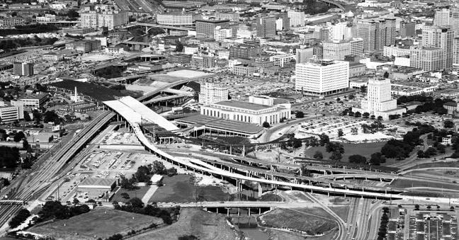
9 124 Houston Freeways Aiming for the downtown crossing: This view shows the terminus of the East Freeway (IH 10) at US 59 in May Right-of-way clearance for IH 10 on the north side of downtown had not yet begun. A substantial number of structures were in the path of the freeway in the mostly industrial area. The westward extension of IH 10 was completed on May 17, (Photo: TxDOT) tablished, leaving the corridor at risk for development. By October 1958, the building lines were reestablished and TxDOT began protective right-of-way acquisition. But lack of funds limited the land acquisition to only a half-block wide strip along Pierce Avenue. The halfblock strip was estimated to cost $8 million and had a final cost of $11 million. A full block strip was estimated at $20 million. After adjusting for inflation in the overall U.S. economy to equivalent values in 2003 dollars, $11 million translates to about $56 million and $20 million translates to about $102 million a large but not daunting cost. However, as a percentage of budgets at the time, $20 million for a full block along Pierce Avenue would have been a huge expenditure. The total TxDOT budget for all of Texas in 1957 totaled $242 million. In relative terms, the cost of a full block along Pierce in 1957 corresponds to about $430 million in TxDOT s 2003 budget of $5.2 billion. There was discussion of acquiring the full block, but limited financial resources ruled it out; getting the money to buy the half-block strip would be difficult enough. But the half-block strip was wide enough for a freeway with only six lanes. The consequences of the 1956 decision to acquire only half a block were being felt in 2003, when TxDOT officials were studying ways to provide relief to the now critically congested Pierce Elevated. 8 Controversy over the Pierce Elevated persisted until 1959, when a landowner was still fighting to have the building lines revoked. By that time, local authorities were not willing to entertain any ideas that would change the alignment of the freeway. TxDOT Houston Urban Project Office head A. C. Kyser stated that changing the route was out of the question, and the Houston Chamber of Commerce rallied its support behind the Pierce Elevated. By July 1960 all challenges to the Pierce Elevated had been dismissed, and approximately half the needed right-of-way had been acquired through protective rightof-way purchases. 9
10 Downtown Freeways 125 Building the Freeways The first construction on downtown Houston freeways was underway by late 1953, consisting of the first phase of present-day IH 45 on the western edge of downtown. The first freeway section, the main freeway lanes of IH 45, opened December 12, For the next 25 years there would be a steady progression of work on the Houston Central Interchange (see map on page 118 with completion dates). On April 11, 1958, the Eastex Freeway was extended into downtown with the opening of the Buffalo Bayou bridge. The Southwest Freeway and its distribution system into downtown via Spur 527 were completed on July 26, On July 24, 1962, IH 45 was completed from the north side of Houston into downtown, forming the first phase of the large IH 45-IH 10 multiplex. The IH 45 interchange structure on the west side of downtown was also finished in 1962 with the addition of collector lanes and connector ramps. In April 1966 the US 59 elevated structure on the east side of downtown was completed. Construction of the Pierce Elevated structure was complete in spring 1965, and it was opened to traffic on August 18, 1967, connecting the North Freeway to the Gulf Freeway. On December 20, 1968, the Katy Freeway (IH 10 West) was brought into downtown Houston, and the multiplex interchange with IH 45 was substantially complete. On May 17, 1972, IH 10 on the north side of downtown between IH 45 and US 59 was opened, completing IH 10 through Houston and the inner loop of freeways around downtown. The last major link in the downtown freeway system was finished on September 27, 1974, with the opening of US 59 between Spur 527 and IH 45. The US 59-SH 288 interchange was completed on November 20, With that project, the Houston Central Interchange was complete. Although major reconstruction of the Gulf Freeway just southeast of downtown would begin in the early 1980s, construction in the immediate downtown area would go into a state of dormancy for about the next 15 years. First Came the Freeways, then the Skyscrapers In the mid-1960s, downtown Houston consisted of a modest collection of mid-rise office structures. By the late 1960s, most of the freeways into downtown Houston were complete and there was greatly improved access to downtown from all parts of the city. In 1970 the regional transportation planning group, the Houston-Harris County Transportation Study, published a report on the central business district which stated, There is less traffic congestion travelling to or from the Houston central business district than in any city of comparable size. Comparative travel time studies conducted in 1960, 1965, and 1969 have shown that during the evening peak hours the travel time has been vastly improved in all directions except for the Gulf Freeway, although this facility is showing improvements compared with The reason for these improvements was, of course, the new freeway system. In terms of motorists ability to efficiently travel during rush hour, 1970 would later be recognized as the year of peak Key dates in Houston s downtown freeways 1945 Official TxDOT authorization to begin study of downtown freeways Gulf Freeway opens southeast of downtown with an extensive distribution system into downtown streets The general plan for the downtown Houston freeway system is finalized as part of an overall freeway plan for the Houston region First downtown freeway segment opens, a short section of IH 45 on the west side of downtown The detailed plan for the downtown Houston freeway system is finalized The Pierce Elevated section of IH 45 opens IH 10 north of downtown opens, completing the loop around downtown US 59 south of downtown opens, completing all downtown main lanes in the original plan except the cancelled Harrisburg Freeway The US 59-SH 288 interchange opens, completing the originally planned downtown freeway system The second wave of downtown construction begins with rehabilitation work and a large new interchange at US 59 and IH Work begins on the complicated reconstruction of the Southwest Freeway (US 59) downtown approach Completion of the US 59-IH 10 interchange Scheduled completion of the Hardy Toll Road freeway extension into downtown, almost certainly the last new freeway for downtown. Future Potential improvement and expansion of IH 45 and US 59. mobility in Houston. 10 It didn t take long before downtown Houston was transformed into one of the more impressive skylines in the United States. In 1960, the central business district had 10 million square feet of office space, increasing to about 16 million square feet in Downtown Houston was on the threshold of a boom in 1970 with 8.7 million square feet of office space planned or under construction and huge projects being launched by real estate developers. * The surge of skyscrapers mirrored the skyscraper booms in other freeway cities, especially Los Angeles and Dallas. Houston s downtown construction was further fueled by the 1970s energy industry boom. The first major skyscraper to be constructed in Houston was the 50-floor, 714-foot-tall (218 m) One Shell Plaza in A succession of skyscrapers were built through the 1970s, culminating with Houston s tallest skyscraper, the 75-floor, 1,002-foot-tall (305 m) JPMorgan Chase Tower (formerly the Texas Commerce Tower), completed in In 2002 it was the ninth tallest building in the * The largest proposed development was the 32-block Houston Center. Only a small part of the original proposal was ultimately constructed. Other large projects included Cullen Center, Allen Center, and towers for Shell Oil.

11 126 Houston Freeways Pre-freeway downtown: This 1967 photograph shows the modest collection of mid-rise office buildings that comprised downtown before the completion of the downtown freeway network. By 1968 most of the spokes leading into downtown were complete, and in 1974 the final section of main lanes in the originally planned downtown freeway network was opened to traffic. Houston s skyline was transformed in the 16-year period from 1971 to (Photo: TxDOT) Downtown Houston s tallest skyscrapers Height Name (2003) Address Feet Meters Floors Completed 1. JPMorgan Chase Tower 600 Travis 1, Wells Fargo Plaza 1000 Louisiana Bank of America Center 700 Louisiana Texaco Heritage Plaza 1111 Bagby Louisiana 1100 Louisiana Reliant Energy Plaza 1111 Louisiana Continental Center 1600 Smith Chevron Tower 1301 McKinney One Shell Plaza 910 Louisiana Smith Street 1400 Smith Data: Skyscrapers.com

12 Downtown Freeways 127 The Houston skyline, September 2002: The downtown Houston building boom came to an end in 1986 with the collapse of Houston s energy economy. Since 1987, all newly constructed office towers have been no more than 40 floors tall. The popularity of suburban, campus-style office space seems to suggest that Houston s skyline will not receive any major new high-rise additions for the indefinite future. Still, downtown Houston remained vibrant in the 1990s and 2000s with the construction of new housing, sports stadiums, and the rebuilding of basic infrastructure. United States and the 23rd tallest skyscraper in the world. In 1983 the 71-floor, 970-foot-tall (296 m) Wells Fargo Plaza was completed. Skyscraper construction in downtown Houston came to an end in the mid-1980s with the collapse of Houston s energy industry and the resulting severe economic recession. When the 53-floor Texaco Heritage Plaza was completed in 1987, it appeared that no more skyscrapers would be constructed for a long, long time. In 2000, however, the Houston-based Enron Corporation began construction of a 40-floor skyscraper which was nearing completion in late 2001, just as the company collapsed in one of the most dramatic corporate failures in the history of the United States. Other smaller office structures were built in the period. In December 2001, downtown Houston had approximately 40 million square feet of office space, including 28 million square feet of class A office space. 11 In spite of the impressive skyline and freeway network, urban advocates in the 1980s complained that downtown Houston was hollow, becoming nearly deserted at the end of the business day. Houston s underground tunnel system kept office workers below ground, inhibiting street activity. Downtown Houston would achieve revitalization in the 1990s, a renaissance engineered by Mayor Bob Lanier, Houston s great road building advocate of the post-1980 era. After concentrating his efforts on transportation in the 1980s, Lanier was elected mayor in 1991 and focused on making the city safe and rebuilding basic infrastructure, including roads and sidewalks. When Lanier exited the mayor s office at the end of 1997 due to term limits, the revitalization of downtown was in full progress. Numerous apartment and loft-style residential structures were built, bringing long-sought urban dwellers into the core of downtown. Lanier s successor, Lee Brown, sought to capitalize on the downtown momentum by constructing a light rail line on Main Street. Construction on the rail line began in 2001 and is scheduled for opening in The Second Wave In the United States, construction and improvement of downtown freeways was largely dormant by the 1970s. Freeways in downtown districts had fallen into disfavor with planners who became more interested in promoting transit and pedestrian activity. Some viewed freeways as

13 128 Houston Freeways Houston s freeways turn into lakes: Tropical Storm Allison in June 2001 unleashed a major flood event, and Houston s freeways sustained some of the most dramatic flooding. Virtually all depressed freeways around Houston filled with water. Flooding along White Oak Bayou submerged much of the at-grade interchange of IH 45 and IH 10 north of downtown, shown above in a photo taken June 9, (Photo: Houston Chronicle) barriers, cutting off parts of the city from each other. Los Angeles, always the bellwether, typified this trend. Much of its downtown interchange complex dates from the early 1950s and was complete by It has seen practically no improvement since its original completion, and no major improvement is planned in the future. The Los Angeles downtown freeway complex is certainly showing its age. Phoenix, Arizona, in a project completed in 1990, placed a downtown section of IH 10 in a tunnel to minimize impacts. Boston, Massachusetts, spent a staggering $15 billion to rid its downtown of freeways by burying them underground. But Houston would retain and improve its downtown freeway system starting in the mid-1990s. The Pierce Elevated, IH 45 on the south side of downtown, was reconstructed in US 59 on the east side of downtown was resurfaced and widened to eight continuous lanes in In October 2000, a long, elevated connector ramp for buses and high occupancy vehicles was completed over the IH 10-IH 45 interchange on the northwest side of downtown. In 1998, the first major construction since the completion of the downtown interchange complex in 1980 was underway. A major new interchange took shape on the northeast side of downtown at the intersection of Eastex Freeway (US 59) and the East Freeway (IH 10). Included in the interchange is the downtown distribution system originally envisioned by planners in the 1950s. The operational efficiency of the distribution system may be compromised when it opens in 2004 because a new baseball stadium was constructed on the location of the former Union Station rail yard. The stadium ensures a permanent barrier to north-south traffic flow where the connection ramps reach downtown streets. The new interchange will also accommodate a planned new radial spoke for the downtown freeway system, the extension of the Hardy Toll Road into downtown Houston as a toll-free facility. Construction of the Hardy Toll Road extension is expected to begin in 2005, with completion around In 2003 a comprehensive study is in progress to determine future improvements to IH 45 and the section of US 59 south of IH 45. The six-lane Pierce Elevated section of IH 45 has become a critical bottleneck in Houston s freeway system. The study will identify needed improvements and determine what is feasible for the Pierce Elevated, which has high-rise structures immediately adjacent to it. At the very minimum, the oldest sections of Houston s downtown interchange complex should be brought up to modern standards, and recommendations could include major expansions or additions.
 side of Pierce.")

14 Pierce, before the elevated: This view looks west along Pierce Avenue at Jackson, prior to the construction of the Pierce Elevated section of IH 45. The Pierce Elevated was constructed immediately adjacent to the south (left) side of Pierce. Although the corridor for the elevated freeway consisted mostly of vacant lots and lower-tier commercial establishments, it was the most controversial section of freeway in the downtown interchange complex. Commercial interests owning property in the path of the freeway had plans for developing their property. Lawsuits were filed, but by 1960 all challenges were dismissed and the freeway moved forward on its originally planned alignment along Pierce, opening in August (Photo: TxDOT) The orphan ramp, : This connector ramp overpass at the south end of the IH 45-IH 10 interchange was completed in 1962 with the construction of IH 45. However, the section of IH 10 which would use this ramp was not completed until The idle ramp prompted speculation from many motorists, including one person who wrote to the Houston Chronicle in 1967 believing that current plans don t call for its use and it will just stand there forever. 12 (Photo: Greater Houston Partnership)
 and US 59 (left to right) are indicated by the dashed lines. Excavation work had already begun for US 59 in the lower section of the photo.")
15 130 Houston Freeways On the eve of freeway construction: This 1963 aerial view of the southeast side of downtown shows the area just before freeway construction projects would begin. The routes of IH 45 (top to bottom) and US 59 (left to right) are indicated by the dashed lines. Excavation work had already begun for US 59 in the lower section of the photo. Right-ofway clearance is in progress along Pierce Avenue. (Photo: The Positive Image)

16 Downtown Freeways 131 Critical bottleneck: The six-lane Pierce Elevated, named after the street immediately adjacent to it, has become the most critical bottleneck in the downtown interchange complex. Designed to carry 75,000 vehicles per day, the freeway was serving approximately 200,000 vehicles per day in As this photo shows, large structures alongside the freeway make a major expansion very difficult. In the foreground is the interchange with US 59. The US 59 main lanes are depressed below grade and are not visible in this view. (Photo: May 2002)

 The unbuilt: This view shows a section of the final plan for the downtown interchange complex, which was approved in 1963.")
17 IH 10 north of downtown: This section of freeway, opened on May 17, 1972, is simple and basic in comparison to other freeways in the downtown interchange complex. The dedication ceremony coincided with the retirement of Albert C. Kyser, head of the TxDOT Houston Urban Project Office from 1955 to Kyser and City of Houston Planning Director Ralph Ellifrit were the most influential persons in the design of the downtown interchange complex. (Photo: July 2002) The unbuilt: This view shows a section of the final plan for the downtown interchange complex, which was approved in The La Porte Freeway, also known as the Harrisburg Freeway for the unbuilt section inside Loop 610, was planned to terminate at US 59 near what is now the baseball stadium for the Houston Astros. The La Porte Freeway was cancelled in the mid-1970s due to community opposition and funding shortages. It is the only part of the originally planned downtown interchange complex that was not constructed. (Map: HMRC)

18 Downtown Freeways 133 IH 45 construction: This view shows the construction of IH 45 on the north side of downtown in May 1961 at the location of the multiplex interchange with IH 10. Initially only IH 45 was constructed through the interchange. This section of freeway parallels White Oak Bayou and followed an ideal freeway corridor due to the limited development. Houston s 1942 Major Street Plan identified the White Oak Bayou corridor as one of the three best potential alignments for new freeways. (Photo: TxDOT)


19 134 Houston Freeways One freeway complete, one to come: These views show the IH 45-IH 10 multiplex interchange prior to the construction of IH 10. The wide median and adjacent cleared right-of-way would later become IH 10 and its connection ramps. The upper photo was taken just after the freeway opening in July The lower photo was taken in December (Photos: upper, HMRC MSS ; lower, TxDOT)

20 Downtown Freeways 135 Transitways finish the interchange: The interchange remains in its original 1968 configuration, except for the addition of transitway lanes. The elevated transitway ramp for high-occupancy vehicles was opened October 16, (Photo: September 2002)
 (Opposite page) Scorched earth turns into freeway: These photos show before and after views of the US 59-SH 288 multiplex interchange on the south side of downtown.")
21 136 Houston Freeways US 59 construction: This view shows construction of the interchange at US 59 and IH 45 in April The IH 45 main lanes had previously opened in (Photo: TxDOT) (Opposite page) Scorched earth turns into freeway: These photos show before and after views of the US 59-SH 288 multiplex interchange on the south side of downtown. The construction of this wide freeway required the largest right-of-way clearance in the construction of the downtown interchange complex. In the upper photo, taken in January 1969, rightof-way clearance is just about complete. The freeway was opened to traffic on September 27, The entire interchange was finished in 1980 with the completion of connections to the SH 288 South Freeway, shown in the far distance in the lower photo. (Photos: upper, Houston Chronicle; lower, May 2002)


22

23 138 Houston Freeways Construction of the US 59 Buffalo Bayou bridge, November 1957: The completion of this link on April 11, 1958, brought the Eastex Freeway into downtown Houston. The row of buildings just to the left of the freeway is the Clayton Homes housing project, which opened March 22, It replaced Schrimpf Alley, which was reportedly the worst slum district in Houston. Land acquisition costs for the Clayton Homes project were paid by Susan V. Clayton, wife of Houston cotton magnate and statesman William L. Clayton. 13 (Photo: TxDOT)


24 US 59 gets its downtown connections: These photos show the new interchange complex being constructed on the Eastex Freeway (US 59 North) approach to downtown. Original plans for the downtown Houston freeway system included a complete distribution system for each freeway coming into downtown, but plans for the Eastex Freeway were dropped because the Union Station rail yard blocked the needed feeder streets. In the late 1990s work began to rebuild the US 59-IH 10 interchange and add a distribution system for the Eastex Freeway. In the upper photo, the original US 59 structure is the second from the right and was in the process of being demolished when the photo was taken in May In the photo at left, taken in November 2002, the original bridge structure has been almost completely demolished all that remains are a few piers near the bottom of the photo. The new US 59 southbound main lanes were constructed on the location of the demolished original bridge. The project is scheduled for completion in The US 59 downtown distribution system and accompanying reconstructed interchange at IH 10 is the first new-facility construction in downtown Houston since the original completion of the interchange complex in 1980.

25 140 Houston Freeways Freeway with a view: The elevated structures on IH 45 skirting the west and south edges of downtown provide motorists with outstanding views. When the Pierce Elevated section of IH 45 opened in 1967, the Houston Chronicle took note of the impressive driving experience provided by the elevated freeways: Not only does it speed the traffic flow, it also affords motorists a magnificent view of the business district. It s almost like going up in a cable car. 14 (Photo: May 2003) (Opposite page) Where the freeways come together: Looking north along the IH 45-IH 10 interchange north of downtown. (Photo: November 2002)

26
IMPLEMENTATION OF COMPREHENSIVE DEVELOPMENT AGREEMENT (CDA) PROJECTS:
 PROJECTS:") IMPLEMENTATION OF COMPREHENSIVE DEVELOPMENT AGREEMENT (CDA) PROJECTS: SH 130 Project, Segments 5 & 6, Travis, Caldwell and Guadalupe counties; DFW Connector, Tarrant County; North Tarrant Express (NTE),
IMPLEMENTATION OF COMPREHENSIVE DEVELOPMENT AGREEMENT (CDA) PROJECTS: SH 130 Project, Segments 5 & 6, Travis, Caldwell and Guadalupe counties; DFW Connector, Tarrant County; North Tarrant Express (NTE),
A. CONCLUSIONS OF THE FGEIS
 Chapter 11: Traffic and Parking A. CONCLUSIONS OF THE FGEIS The FGEIS found that the Approved Plan will generate a substantial volume of vehicular and pedestrian activity, including an estimated 1,300
LANCASTER CORRIDOR REDEVELOPMENT ROSEDALE STREET REDESIGN PEACH STREET RAILROAD CROSSINGS
 LANCASTER CORRIDOR REDEVELOPMENT ROSEDALE STREET REDESIGN PEACH STREET RAILROAD CROSSINGS Presented at the SEE Development Excellence Workshop By Councilmember Wendy Davis, City of Fort Worth March 24,
Southwest LRT Alignment Video Narration
 Southwest LRT Alignment Video Narration September 2015 Southwest Light Rail Transit, a proposed extension of the METRO Green Line, will serve Minneapolis, St. Louis Park, Hopkins, Minnetonka and Eden Prairie.
MEMORANDUM. for HOV Monitoring on I-93 North and the Southeast Expressway, Boston Region MPO, November, 2011.
 MEMORANDUM Date: January 12, 2012 To: Congestion Management Process Files From: Seth Asante, Ryan Hicks, and Efi Pagitsas MPO Staff Re: Historical Trends: Travel Times and Vehicle Occupancy Levels for
At the time, the portion of the line through Eagle County remains wholly under the ownership of Union Pacific Railroad (UP).
.") Chapter 5 The Railroad Corridor as a Trail Corridor The intent of this chapter is to identify how the rail corridor, if available for lease or purchase in all or part, could be incorporated into the core
Chapter 5 The Railroad Corridor as a Trail Corridor The intent of this chapter is to identify how the rail corridor, if available for lease or purchase in all or part, could be incorporated into the core
Sam Houston Parkway/Tollway, Beltway 8
 Sam Houston Parkway/Tollway, Beltway 8 Even before the alignment of Loop 610 had been finalized, the city of Houston was formulating plans for a second loop. It was a remarkable act of vision and foresight
3. COLTA / HUGA CONNECTIONS - PRELIMINARY
 9 3. COLTA / HUGA CONNECTIONS - PRELIMINARY 3.1 COLTA The Chain of Lakes Trail Association (COLTA) trail, formerly identified as the Chester Spur Line, was completed and opened for use in June 2011. The
Basic Project Information
 FY 2015-16 PROJECT DESCRIPTION FORM (2C) Submitting Agency: Loudoun County Basic Project Information Project Title: Loudoun County Parkway (VA Route 607) U.S. 50 to Creighton Rd. (2C) Project Type (check
Airport Planning Area
 PLANNING AREA POLICIES l AIRPORT Airport Planning Area LOCATION AND CONTEXT The Airport Planning Area ( Airport area ) is a key part of Boise s economy and transportation network; it features a multi-purpose
Draft Concept Alternatives Analysis for the Inaugural Airport Program September 2005
 Draft Concept Alternatives Analysis for the Inaugural Airport Program September 2005 Section 3 - Refinement of the Ultimate Airfield Concept Using the Base Concept identified in Section 2, IDOT re-examined
EXTERNAL COMMUNICATIONS TEAM MEETING MARCH 2015
 EXTERNAL COMMUNICATIONS TEAM MEETING MARCH 2015 1 SEGMENT 1 2 THE WISHBONE Connects the TEXpress Managed Toll System to the 35Express Managed Toll System Limits: Crown Road (near Royal Lane) to Valley
35EXPRESS PROJECT UPDATE FOR DENTON COUNTY COMMISSIONERS
 35EXPRESS PROJECT UPDATE FOR DENTON COUNTY COMMISSIONERS 35EXPRESS PROJECT OVERVIEW 2 ABOUT THE 35EXPRESS PROJECT 3 DESIGN-BUILD TEAM 4 PROJECT PARTNERS Great partnerships make this project work Collaboration
2017 POLICY DOCUMENT. M1 Action Plan. Putting Queenslanders First
 2017 POLICY DOCUMENT Putting 2 Contents Message from the Premier 3 Our Commitment 4 The Newman-Nicholls Legacy 5 The Palaszczuk 6 Government s Record Our Plans: Putting 8 Call: 07 3844 8101 Mail: PO Box
Lake Erie Commerce Center Traffic Analysis
 LOCATION: East of NYS Route 5 at Bayview Road Town of Hamburg Erie County, New York PREPARED BY: Wendel Companies 140 John James Audubon Parkway Suite 200 Amherst, New York 14228 January 2012 i ii Table
5.1 Traffic and Transportation
 5.1 When it opens in 2009, the Bellevue Nickel Improvement Project will increase the number of vehicles able to travel through the study area, improve travel speeds, and improve safety by reducing the
12, 14 and 16 York Street - Amendments to Section 16 Agreement and Road Closure Authorization
 REPORT FOR ACTION 12, 14 and 16 York Street - Amendments to Section 16 Agreement and Road Closure Authorization Date: April 27, 2018 To: Toronto and East York Community Council From: Senior Strategic Director,
The West Loop: One of the most impressive instances of an edge city has risen along the West Loop. This view looks north along the West Loop with the
 The West Loop: One of the most impressive instances of an edge city has risen along the West Loop. This view looks north along the West Loop with the Southwest Freeway interchange in the foreground. (Photo:
2nd Annual Historic L Station Tour. November 19, Presented By: The Illinois Historic Preservation Agency
 2nd Annual Historic L Station Tour November 19, 2000 Presented By: The Illinois Historic Preservation Agency With: Chicago-L.org The Chicago Design Consortium 2nd Annual Historic L Station Tour Guide Dearborn-Milwaukee
EXTERNAL COMMUNICATIONS COMMITTEE MEETING APRIL 2015
 EXTERNAL COMMUNICATIONS COMMITTEE MEETING APRIL 2015 35EXPRESS PROJECT OVERVIEW 2 SEGMENT 1 3 SOUTH OF I-635 May Shift northbound mainlane traffic east in the southeast quadrant Miscellaneous frontage
A. From I-68 in Monongalia County, West Virginia to SR 6119 in Fayette County, Pennsylvania 1
 Mon-Fayette Transportation Project A. From I-68 in Monongalia County, West Virginia to SR 6119 in Fayette County, Pennsylvania 1 The Mon/Fayette Transportation Project (MFTP) from I-68 in West Virginia
Mission Statement. Spur 601 Project Highlights
 Mission Statement SPUR 601 is a TxDOT project dedicated to provide a safe, efficient, reliable new corridor to improve the mobility in east-central El Paso. The SPUR 601 team is working in partnership
TRAIL ANNUAL REPORT
 TRAIL ANNUAL REPORT 2016-17 Identify Undeveloped projects identified in the City s Greenprint or trail database 15.90 miles Study Projects that have been or are currently being studied to determine a feasible
C. APPROACH FOR IDENTIFYING THE BEST ROUTES FOR THE NEEDED TRANSMISSION SYSTEM IMPROVEMENTS
 C. APPROACH FOR IDENTIFYING THE BEST ROUTES FOR THE NEEDED TRANSMISSION SYSTEM IMPROVEMENTS CL&P s approach for identifying the best routes for the needed transmission system improvements included a determination
Score. Category. Access Aesthetics Community Resources
 NO BUILD ALTERNATIVE The No Build Alternative is the do nothing option that is used for comparison to the build alternatives. The screening assumes no new facilities are constructed as part of the I-93
ALL ABOARD LABOR S LONG TERM PASSENGER TRANSPORT STRATEGY
 ALL ABOARD LABOR S LONG TERM PASSENGER TRANSPORT STRATEGY Revitalising Passenger Transport Increasing traffic congestion in our cities and a lack of transport services in our regional towns is frustrating
SOUTHBOUND YONGE STREET TO EASTBOUND HIGHWAY 401 F L Y -UNDER
 SOUTHBOUND YONGE STREET TO EASTBOUND HIGHWAY 401 F L Y -UNDER Proposal to Eliminate Traffic Gridlock in South North York Centre Area With Southbound Yonge Street to Eastbound Highway 401 Fly-UNDER A much
Draft Concept Alternatives Analysis for the Inaugural Airport Program September 2005
 Section 10 Preferred Inaugural Airport Concept 10.0 Introduction The Preferred Inaugural Airport Concept for SSA was developed by adding the preferred support/ancillary facilities selected in Section 9
IRONTON-RUSSELL BRIDGE REPLACEMENT
 IRONTON-RUSSELL BRIDGE REPLACEMENT 2012-2016 District 9 Ohio Department of Transportation Ironton-Russell Bridge Replacement Existing Ironton-Russell Bridge Ironton-Russell Bridge Replacement Existing
Update on the I-680 Transit Corridor Improvement Project HOV on/off Ramps Environmental Impact Report Community Engagement Plan
 Update on the I-680 Transit Corridor Improvement Project HOV on/off Ramps Environmental Impact Report Community Engagement Plan Presentation Overview Introductions Susan Miller, Director of Projects, Contra
Spadina Avenue which would include two new underground stations located at Yonge Street and at University Avenue.
 TORONTO TRANSIT COMMISSION REPORT No S7 MEETING DATE June 4, 1968 FROM: General Manager Subway Construction Date June 3, 1968 Subject: QUEEN STREET SUBWAY FOR STREETCAR OPERATION The Commission, at its
Gold Coast. Rapid Transit. Chapter twelve Social impact. Chapter content
 Gold Coast Rapid Transit Chapter twelve Social impact Chapter content Social impact assessment process...235 Existing community profile...237 Consultation...238 Social impacts and mitigation strategies...239
Site Location and Setting
 Memorandum Date: To: From: Subject: Kristy Le, Gary Black Steve Orem Santa Teresa County Park Historic Area Traffic and Parking Study Hexagon Transportation Consultants, Inc. has completed a traffic and
Interstate 90 and Mercer Island Mobility Study APRIL Commissioned by. Prepared by
 Interstate 90 and Mercer Island Mobility Study APRIL 2017 Commissioned by Prepared by Interstate 90 and Mercer Island Mobility Study Commissioned by: Sound Transit Prepared by: April 2017 Contents Section
2006 WEEKDAY TRAFFIC PROFILE. June 15, 2007
 June 15, 2007 Mr. Gary Stobb, P.E. Director of Planning/Operations Harris County Toll Road Authority 330 Meadowfern, Suite 200 Houston, TX 77067 Re: Westpark Tollway Value Pricing Analysis Dear Mr. Stobb:
4. Safety Concerns Potential Short and Medium-Term Improvements
 NH Route 104 Access Management Study Page 19 4. Safety Concerns Potential Short and Medium-Term Improvements Potential safety improvement strategies are listed by priority based on field observations by
NFTA Access Enhancement Study for Canalside and Cobblestone Alternatives Discussion. Alternative A South Park Avenue
 Alternative A South Park Avenue Alternative A Summary Alternative A extends Metro Rail service around the foot of Main Street east along South Park Avenue to serve a new station platform located along
Table of Contents. List of Tables. Cincinnati/Northern Kentucky International Airport 2035 Master Plan Update
 Table of Contents 7.1. Airport Layout Plan (Existing Conditions)... 2 7.2. Airport Layout Plan (Future Conditions)... 3 7.3. Technical Data Sheet... 5 7.4. Commercial Terminal Area Drawing... 5 7.5. East
Funding Package TOTAL $15,172,000
 Funding Package ACT 13 $3,000,000 Transportation Capital Budget $5,000,000 Redevelopment Capital Program(RACP) $3,000,000 Passenger Facility Charge (PFC) $1,500,000 Multimodal Transportation (DCED) $1,500,000
One Shell Plaza Houston, Texas 77002
 One Shell One Shell is a 50-story Class A building containing approximately 1.23 million square feet. The building is located in the heart of the central business district with excellent ingress and egress
Fair Park Comprehensive Development Plan Update. City Council Briefing November 5, 2007
 1 Fair Park Comprehensive Development Plan Update City Council Briefing November 5, 2007 Introduction Park and Recreation Department Renaissance Plan focused on eight Big Moves: Upgrade current parks Provide
A number of goals were identified during the initial work on this Big Lake Transportation Plan.
 C. Transportation General Background Information Big Lake s transportation system includes all the roads, paths and facilities that allow the movement of private vehicles, trains and planes, as well as
TORONTO TRANSIT COMMISSION REPORT NO.
 Revised: March/13 TORONTO TRANSIT COMMISSION REPORT NO. MEETING DATE: November 18, 2013 SUBJECT: YONGE-EGLINTON AND EGLINTON WEST INTERCHANGE STATIONS METROLINX EGLINTON CROSSTOWN LIGHT RAIL TRANSIT PROJECT
user s guide to Transportation Improvements in Astoria Planning Efforts outside Astoria for more information, contact:
 The Miles Crossing/ Jeffers Garden transportation plan (underway), will identify needed improvements to the Warrenton Astoria Highway and local street improvements to serve expected growth in the Miles
Arlington County Board Meeting Project Briefing. October 20, 2015
 Arlington County Board Meeting Project Briefing October 20, 2015 Project Map 2 Project Context Only Interstate in the Country limited to HOV only traffic during rush hours Stoplight at the end of I-66
Westbrook Station. Transit Oriented Development Opportunity
 DEVELOPM Westbrook Station Transit Oriented Development Opportunity OPPOR Table of Contents Prime Real Estate Development Opportunity page 1 Calgary City of Opportunity page 3 What is Transit Oriented
// LEARN // ENGAGE // VOLUNTEER // DONATE // PROJECT OVERVIEW MAP
 // LEARN // ENGAGE // VOLUNTEER // DONATE // PROJECT OVERVIEW MAP PROJECT OVERVIEW MAP The Atlanta BeltLine is a dynamic and transformative project for Atlanta. Through the development of a new transit
Texas Transportation Institute The Texas A&M University System College Station, Texas
 1. Report No. FHWA/TX-05/0-4434-P1 2. Government Accession No. 3. Recipient's Catalog No. 4. Title and Subtitle GUIDANCE FOR FUTURE DESIGN OF FREEWAYS WITH HIGH- OCCUPANCY VEHICLE (HOV) LANES BASED ON
DOWNTOWN BRT ALTERNATIVE - 19th AVE
 DOWNTOWN BRT ALTERNATIVE - 9th AVE New Route and Increased Service in Mixed Traffic Existing Route and Service in Mixed Traffic Light Rail Line / New Route and Increased in Exclusive Guideway Existing
FY Year End Performance Report
 Overall Ridership Big Blue Bus carried 18,748,869 passengers in FY2014-2015, a 0.3% reduction from the year prior. This negligible reduction in ridership represents the beginnings of a reversal from a
Guide to. Road Construction Projects
 Guide to Road Construction Projects 2018 Spring is here and so is road construction season. This year PennDOT District 11-0 will invest an estimated $208 million on 68 projects to improve, preserve or
2017 TBARTA Future Regional Priority Projects Adopted by TBARTA Board, December 9, 2016
 2017 TBARTA Future Regional Priority Projects Adopted by TBARTA Board, December 9, 2016 Project numbers do not signify ranking they are for mapping identification purposes only. 1. 15th Street East The
Corridor Management Committee Meeting. April 2, 2014
 Corridor Management Committee Meeting April 2, 2014 1 Today s Topics Welcome Approval of Minutes Resolutions Response to March 26 CMC Questions Staff Recommendation on Project Scope and Budget Public Testimony
TEMPE BEACH PARK - RECOMMENDATIONS
 TEMPE BEACH PARK - RECOMMENDATIONS Tempe Beach Park has the potential to become a regional destination park, but it suffers from a host of physical and operational problems, as well as structural flaws.
November 9, Society of American Military Engineers
 November 9, 2016 Society of American Military Engineers Transit Operator Transportation Planner Transportation Infrastructure Builder Transportation Funding Overseer 2 1,433 square-mile service area (nearly
Phoenix Sky Harbor transit guideway bridge
 Phoenix Sky Harbor transit guideway bridge by David A. Burrows, Gannett Fleming The evolution of the PHX Sky Train s crossing of Taxiway Romeo At one of the 10 busiest airports in the United States, cast-in-place,
Building Kendall a toll expressway: Traffic relief or 'Band-aid over a gaping wound?'
 Building Kendall a toll expressway: Traffic relief or 'Band-aid over a gaping wound?' By Douglas Hanks April 20, 2018 08:47 PM Traffic is bad in West Kendall. Will extending the Dolphin Expressway, pictured
Oakland A s Gondola Economic Impact
 January 2019 Oakland A s Gondola Economic Impact KEY FINDING: The proposed gondola system, which will connect the A s planned stadium to downtown Oakland, will generate $685 million in total economic benefit
RACINE COUNTY PUBLIC TRANSIT PLAN:
 RACINE COUNTY PUBLIC TRANSIT PLAN: 2013-2017 Recommended Transit Service Improvement Plan NEWSLETTER 3 SEPTEMBER 2013 This newsletter describes the final recommended public transit plan for the City of
Research Report Agreement T4118, Task 24 HOV Action Plan HOV ACTION PLAN
 Research Report Agreement T4118, Task 24 HOV Action Plan HOV ACTION PLAN by John M. Ishimaru Senior Research Engineer Duane Wright Systems Analyst Programmer Mark E. Hallenbeck Director Jaime Kang Research
Item # 28. Chief Capital Management Officer Report. November 20, 2008
 Item # 28 Chief Capital Management Officer Report November 20, 2008 1 Metro Gold Line Eastside Extension Project Update November 2008 6 Mile Alignment 1.7 Miles of Tunnel 8 Stations (6 At-grade & 2 Underground)
SCOPING INFORMATION PACKET
 SCOPING INFORMATION PACKET Project Description The proposed project would provide a direct link connecting several light rail lines in operation or in construction, including the Metro Gold Line to Pasadena,
DULLES AREA HIGHLIGHTS. Gary Garczynski Commonwealth Transportation Board Northern Virginia District. Committee for Dulles August 4, 2016
 DULLES AREA HIGHLIGHTS Gary Garczynski Commonwealth Transportation Board Northern Virginia District Committee for Dulles August 4, 2016 Smart Scale (formerly HB2) Overview Round 1 completed with the adoption
Aviation, Rail, & Trucking 6-1
 6-1 This chapter describes the services, facilities, and condition of air, rail, and trucking as components of the transportation system. These three intermodal areas have an impact on the factors to be
Metro Gold Line Eastside Extension Review Advisory Committee October 9, 2008
 Review Advisory Committee October 9, 2008 6 Mile Alignment 1.7 Miles of Tunnel 8 Stations (6 At-grade & 2 Underground) Park & Ride Facility Direct Connection to the Pasadena Metro $898.8 million On-Time/Within
Post Oak Blvd & San Felipe St
 MEMORIAL PARK RIVER OAKS UPTOWN PARK FREEWAY WEST LOOP FOUR OAKS PLACE ASTORIA CONDOS BELFIORE CONDOS FOUR LEAF TOWERS BHP BILLITON HQ FRESH MARKET WESTBRIAR LANE 1.6 ACRE DEVELOPMENT SITE STREET FELIPE
Northwest Corridor LRT Line to Irving/DFW
 Northwest Corridor LRT Line to Irving/DFW SCOPING March 10, 2005 NW to Irving/DFW Agenda: Introductions Project Development Process Project Update Federal Involvement Scoping Project Schedule Decisions
Metro ExpressLanes April 5, 2011 Community Meeting re: Adams Blvd Improvements
 Metro ExpressLanes April 5, 2011 Community Meeting re: Adams Blvd Improvements Jan Perry Councilwoman, District 9 Welcome Remarks Arthur T. Leahy Chief Executive Officer, Metro Metro ExpressLanes Overview
PCAL Case Study Retail Areas: Rouse Hill Town Centre
 PCAL Case Study Retail Areas: Rouse Hill Town Centre Introduction Rouse Hill Town Centre is a new mixed use development on a greenfield site in Sydney s North West. It has been planned to be a major hub
Treasure Island Supplemental Information Report Addendum
 1 1 1 1 0 1 0 1 0 1 Treasure Island Supplemental Information Report Addendum Introduction Purpose The purpose of this Supplemental Information Report (SIR) Addendum is to determine if the current land
NEWS RELEASE. EL PASO DISTRICT Jennifer Wright (915) a TxDOT Project For immediate release.
 a TxDOT Project For immediate release.") NEWS RELEASE a TxDOT Project For immediate release EL PASO DISTRICT Jennifer Wright (915) 790-4340 Jennifer.Wright3@txdot.gov January 18, 2017 Mesa Continuous for 6 weeks The following closures started
NEWS RELEASE a TxDOT Project For immediate release EL PASO DISTRICT Jennifer Wright (915) 790-4340 Jennifer.Wright3@txdot.gov January 18, 2017 Mesa Continuous for 6 weeks The following closures started
A CASE FOR COMPLETING THE JORDAN RIVER PARKWAY: A
 A CASE FOR COMPLETING THE JORDAN RIVER PARKWAY: A safe crossing at 9000 South and 850 West Proposed 9000 South Underpass Parkway Timeline Parkway, Trail, and Tourism Facts Blueprint Jordan River 1971 1973
A VISION FOR EL MIRAGE
 el mirage A VISION FOR EL MIRAGE OASIS, ARIZONA A thriving desert jewel destination with a strong arts district, high-wage employment parks system joined together by cohesive, multi-use accessible trails
Route 29 Solutions Projects
 Your guide to the Route 29 Solutions Projects For full details & continued engagement please visit www.route29solutions.org The Route 29 Solutions Package is a $230 million investment into the improvement
Stage 2 ION: Light Rail Transit (LRT) from Kitchener to Cambridge
 from Kitchener to Cambridge") Stage 2 ION: Light Rail Transit (LRT) from Kitchener to Cambridge Public Consultation Centre (PCC) No. 3 Please Sign-in Cambridge City Hall November 21, 2017 2:00 to 8:00pm Preston Memorial Auditorium
Stage 2 ION: Light Rail Transit (LRT) from Kitchener to Cambridge Public Consultation Centre (PCC) No. 3 Please Sign-in Cambridge City Hall November 21, 2017 2:00 to 8:00pm Preston Memorial Auditorium
Attachment 1: Revitalizing Yonge Downtown Yonge Street
 Attachment 1: Revitalizing Yonge Downtown Yonge Street Photo credit: Downtown Yonge BIA Attachment - Revitalizing Yonge Downtown Yonge Street 1 Photo credit: Downtown Yonge BIA Photo credit: Downtown Yonge
Northern Virginia District State of the District. Helen L. Cuervo, P.E. District Engineer October 18, 2017
 Northern Virginia District State of the District Helen L. Cuervo, P.E. District Engineer October 18, 2017 Susan Shaw, P.E., Megaprojects Director Virginia Department of Transportation American Society
Estero Development Report July 2018 Volume 16, Number 5
 CONTENTS Feature: The future is bright in Estero... Estero s Shopping Centers Are Alive and Well... 2 Estero Development Report July 2018 Volume 16, Number 5 Historical Perspective... 2 Coconut Point...
CITY OF VAUGHAN EXTRACT FROM COUNCIL MEETING MINUTES OF JANUARY 25, 2011
 Item 1, Report No. 1, of the Priorities and Key Initiatives Committee, which was adopted without amendment by the Council of the City of Vaughan on January 25,. 1 RAPID TRANSIT UPDATE TORONTO-YORK SPADINA
Hospital Link Project Project Update September 2015
 Hospital Link Project Project Update September 2015 General The project provides a link between Riverside Drive and the Transitway to the Hospital Ring Road. This link is needed to improve transit service
FY TRANSPORTATION IMPROVEMENT PROGRAM. Authority Projects FY
 Brewster Road Widening and North Avenue Bridge PA04009 This project will provide for the widening of Brewster Road at the south end of the airport as well as the replacement and realignment of the North
Welcome. Green Line in Your Community
 Welcome Green Line in Your Community Today s session will provide you with information on options The City is exploring for connecting the Green Line in the Beltline to the future Inglewood/Ramsay station.
Memorandum. Fund Allocation Fund Programming Policy/Legislation Plan/Study Capital Project Oversight/Delivery Budget/Finance Contract/Agreement Other:
 Memorandum Date: March 23, 2018 To: Transportation Authority Board From: Eric Cordoba Deputy Director Capital Projects Subject: 4/10/18 Board Meeting: San Francisco Freeway Corridor Management Study Update
Having trouble reading this ? View it in your browser. Welcome
 Page 1 of 6 Having trouble reading this email? View it in your browser. IN THIS ISSUE Remembering 2011 and Preparing for 2012 Copper Thefts Increase on West Rail Eiber Neighborhood Resident Recieves "Most
TRANSPORTATION ELEMENT
 Transportation TRANSPORTATION ELEMENT Data, Inventory, and Analysis Prepared by Contents 1.0 INTRODUCTION... 1 2.0 EXISTING CONDITIONS... 1 2.1 Roadways... 1 2.1.1 Jurisdiction... 1 2.1.2 Functional Classification...
Your questions about the future of Robinson Road...answered.
 Your questions about the future of Robinson Road...answered. What is the issue on Robinson Road? The answer is two-fold: regional growth and traffic. Robinson Road is the east bound arterial extending
Appendix 6 Fulbourn Greenway Review
 Appendix 6 Fulbourn Greenway Review Nigel Brigham & Associates A report for 1 Introduction This report is based on fieldwork carried out in 2016 to review the Greenway network around Cambridge as shown
United States Department of the Interior National Park Service. Boundary Expansion Listed in National Register January 11, 2017
 NPS Form 10900-a (Rev. 8/2002) OMB No. 10240018 United States Department of the Interior National Park Service Boundary Expansion Listed in National Register January 11, 2017 National Register of Historic
BUILD. Update CONSTRUCTION. In this issue: FEATURED PROJECT: KENT AVENUE ARCH CONSTRUCTION AT THE SJ RIVER VIADUCT FEBRUARY 2019
 BUILD CONSTRUCTION Update FEBRUARY 2019 In this issue: ARCH CONSTRUCTION AT THE SJ RIVER VIADUCT FEATURED PROJECT: KENT AVENUE * Featured Project KENT AVENUE CP 2-3 CONSTRUCTION UPDATE February 2019 At
Appendix 4.1 J. May 17, 2010 Memorandum from CTPS to the Inter Agency Coordinating Group
 Appendix 4.1 J May 17, 2010 Memorandum from CTPS to the Inter Agency Coordinating Group CTPS CENTRAL TRANSPORTATION PLANNING STAFF Staff to the Boston Region Metropolitan Planning Organization MEMORANDUM
REVITALIZING BUFFALO S WATERFRONT
 REVITALIZING BUFFALO S WATERFRONT HIGHWAYS TO BOULEVARDS INITIATIVE CONGRESS FOR THE NEW URBANISM CENTER FOR NEIGHBORHOOD TECHNOLOGY TWO VERY DIFFERENT CHOICES BUFFALO IS A WATERFRONT CITY WITH A DEEP
National Society of Professional Engineers. Charles S. Carnaggio, PE Project Director July 2, 2014
 National Society of Professional Engineers Charles S. Carnaggio, PE Project Director July 2, 2014 Phase 1 Opening Date: July 26, 2014 Dulles Corridor Metrorail Project At-a-Glance Seamless integration
The Galveston Seawall
 Coastal and Ocean Engineering ENGI.8751 Undergraduate Student Forum Faculty of Engineering and Applied Science, Memorial University, St. John s, NL, Canada. March, 2013 The Galveston Seawall Mark Harvey
Clackamas County Development Agency
 Clackamas County Development Agency Development Services Building, 150 Beavercreek Rd., Oregon City, OR 97045 www.clackamas.us/transportation/renewal 503-742-4323 The Clackamas County Board of Commissioners
Crystal City Station Improvements. Project Overview. Table 2: North Entrance. Table 1: South Entrance. 20th St. S 18th St. S.
 Table 1: South Entrance Table 2: North Entrance 20th St. S 18th St. S Proposed Second Entrance Crystal Drive Existing Station Location Platform Future 4 th Track Future New Airport Connection (by others)
Rails with Trails Finding the mobility, safety, and liability sweet spot 5/10/2017
 Rails with Trails Finding the mobility, safety, and liability sweet spot 5/10/2017 The National Transportation Systems Center Advancing transportation innovation for the public good U.S. Department of
Shore Facilities update and site appraisal June 14.
 Shore Facilities update and site appraisal June 14. As updated at the USCA AGM, feasibility work has continued to try and establish the best location for the shore facilities development that would work
HOV LANE PERFORMANCE MONITORING: 2000 REPORT EXECUTIVE SUMMARY
 Final Report Research Project Agreement No. T1803, Task 4 HOV Monitoring V HOV LANE PERFORMANCE MONITORING: 2000 REPORT EXECUTIVE SUMMARY by Jennifer Nee TRAC Research Engineer John Ishimaru TRAC Senior
State aims to cure accident-plagued South Jersey interchange
 State aims to cure accident-plagued South Jersey interchange 11:52 PM, Apr. 16, 2011 Written by JOE COONEY, Courier-Post Staff GLOUCESTER CITY Anyone who has driven the gantlet known as the I-295/I- 76/Route
PURPOSE AND NEED (CONCURRENCE POINT 1) NEW CANADA ROAD PROJECT FROM STATE ROUTE 1 (U.S. HIGHWAY 70) TO U.S. INTERSTATE 40
 NEW CANADA ROAD PROJECT FROM STATE ROUTE 1 (U.S. HIGHWAY 70) TO U.S. INTERSTATE 40") PURPOSE AND NEED (CONCURRENCE POINT 1) NEW CANADA ROAD PROJECT FROM STATE ROUTE 1 (U.S. HIGHWAY 70) TO U.S. INTERSTATE 40 Project Description The primary purpose of this project is to improve the major
PURPOSE AND NEED (CONCURRENCE POINT 1) NEW CANADA ROAD PROJECT FROM STATE ROUTE 1 (U.S. HIGHWAY 70) TO U.S. INTERSTATE 40 Project Description The primary purpose of this project is to improve the major