DREDGED MATERIAL DISPOSAL HISTORY AVOCA ISLAND LAKE
|
|
|
- Thomas O’Neal’
- 5 years ago
- Views:
Transcription
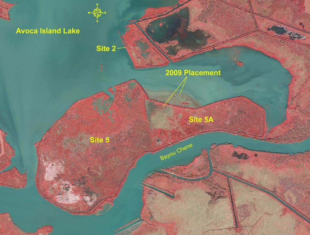
1 DREDGED MATERIAL DISPOSAL HISTORY AVOCA ISLAND LAKE The Atchafalaya River & Bayous Chene, Boeuf, & Black, Louisiana, project was authorized by the Rivers and Harbors Act of 1968, House Document 155, 90 th Congressional Session. It provided for the improvement of a channel 20 feet deep over a bottom width of 400 feet from the vicinity of the US Highway 90 crossing over Bayou Boeuf to the Gulf of Mexico via the Gulf Intercoastal Waterway (GIWW), Bayou Chene, the Avoca Island Cutoff Bayou Drainage channel, the Lower Atchafalaya River, and the existing project across Atchafalaya Bay. This Act also provided for a 20 by 400 foot channel in Bayou Black and the GIWW from the major shipyard on Bayou Black at US Highway 90 to Bayou Chene. Construction on the inland portions of Bayous Boeuf and Black was initiated on April 8, 1977 and completed on January 13, 1978 and June, 1978, respectively. Construction of the final reach, Bayou Chene and Avoca Island Cutoff commenced on October 23, 1980 and was completed on September 28, Fiscal Year 1981 Construction of the Bayou Chene navigational channel was performed during Fiscal Year (FY) 1981 (13 November October 1981). The cutterhead dredges TOM JAMES and FRITZ JAHNCKE, working under contract 81-C-0043, removed a total of approximately 17,754,281 cubic yards of dredged material from the channel. An unknown amount of this dredged material was placed semi-confined in beneficial use disposal Site 5, located on the right descending bank of Bayou Chene in Avoca Island Lake. Earthen retention dikes were constructed/refurbished along the south, east, and west boundaries of disposal Site 5. Dredged material was placed to a maximum height of +3.0 feet Mean Low Gulf (MLG) with the intention of creating marsh islands with areas of shallow open water between islands that would serve as water fowl habitat. However, the silty nature of the dredged material resulted in placed material flowing away once discharged rather than stacking in place. As a result, disposal Site 5 consisted primarily of relatively flat low elevation dredged material interspersed with some areas where the dredged material had stacked to achieve an elevation approaching +3.0 feet MLG. During October 1981, an incidence of avian botulism was discovered in the vicinity of the recently placed dredged material in Avoca Island Lake. An estimated 1,000 ducks and shorebirds had died as a result of this outbreak. U.S. Fish and Wildlife Service personnel determined that a combination of factors, including stagnant water, warm temperatures, and the flat relief of the area, had contributed to the botulism outbreak at this site. It was agreed that future dredged material placement events at the Avoca Island Lake site would take place during the cooler times of the year.


2 Avoca Island Lake Disposal Site 5 29 January 1981 Avoca Island Lake Disposal Site

3 Fiscal Year 1989 During the FY 1989 maintenance event (24 May August 1989), the cutterhead dredges LOUISIANA and E STROUD, working under contract 89-C-0075, removed a total of about 4,614,434 cubic yards from Bayou Chene curves #2, #4, and #5 as part of a channel bendway widening project. An unknown amount of this material excavated from the curves was placed into Avoca Island Lake beneficial use disposal sites 5 and 5A for wetland creation. Dredged material was placed semi-confined in a series of mounds in Site 5 to a maximum initial elevation of +3.5 feet MLG, and placed confined in Site 5A to a maximum initial elevation of +5.0 MLG. By November 1989, a total of approximately 854 acres of wetland habitat had been created in Site 5, and a total of approximately 187 acres of wetland habitat had been created in Site 5A. Fiscal Year 1998 Avoca Island Lake Disposal Sites 5 and 5A November 1989 During the FY 1998 maintenance event (20 June October 1998), the cutterhead dredges TOM JAMES and GEORGE D WILLIAMS, working under contract 98-C-0045, removed a total of about 3,827,625 cubic yards of dredged material from Bayou Chene. Dredged material was deposited confined in Avoca Island Lake disposal sites 5 and 5A for wetland creation. Dredged material was placed to a maximum initial elevation of +4.5 feet MLG.

4 Approximately 3,342,205 cubic yards of dredged material were placed into wetland creation Site 5. Approximately 485,420 cubic yards of dredged material were placed into wetland creation Site 5A. Approximately 223 acres of wetland habitat were created in Site 5, and approximately 154 acres of wetland habitat were created in Site 5A by this placement effort. Avoca Island Site 5 June 1998 Avoca Island Site 5 August 1998
, the cutterhead dredges DREDGE 32 and E STROUD, working under contract 03-C-0047, removed a total of approximately")
5 Avoca Island Lake November 1998 There was no maintenance of this reach of the waterway from FY 1999 through FY Fiscal Year 2003 During the FY 2003 maintenance event (14 July January 2004), the cutterhead dredges DREDGE 32 and E STROUD, working under contract 03-C-0047, removed a total of approximately 4,426,582 cubic yards of dredged material from the Avoca Island Cutoff Bayou Chene channel. A total of approximately 1,012,181 cubic yards of the material were placed into two confined wetland development sites within the Avoca Island Lake dredged material placement area. Disposal Site 2, a 137-acre placement site, received approximately 517,943 cubic yards of material, and disposal Site 5 received approximately 494,238 cubic yards of material. The maximum initial slurry height within both placement sites was +4.5 feet MLG. Although Site 2 retained additional capacity for placement of dredged material, problems with earthen retention dike settling below grade resulted in placement of dredged material into Site 5. Approximately 93 acres of wetland habitat were created in Site 2, and approximately 56 acres of wetland habitat were created in Site 5 with this placement effort.

6 Avoca Island Lake 26 December 2004 Fiscal Year 2009 During the FY 2009 maintenance event (20 August November 2009), the cutterhead dredge DREDGE 32, working under contract 09-C-0099, removed a total of approximately 1,879,545 cubic yards of dredged material from the Bayou Chene channel. A total of approximately 875,964 cubic yards of dredged material were placed confined in the remaining shallow open water portion of Avoca Island Lake disposal Site 5A to a maximum initial elevation of about +4.5 feet MLG. Dredged material was allowed to flow over the Site 5A northern earthen retention dike and be deposited in the shallow open water area of Avoca Island Lake adjacent to, and north of, disposal Site 5A to a maximum initial elevation of about +4.5 feet MLG. The average elevation of these placement sites upon completion of dredging/disposal activities was about +4.0 feet MLG.


7 To help concentrate placement of this dredged material in the open water placement site on the north side of the existing Site 5A earthen retention dike, a silt curtain was installed across the western side of the open water placement site extending from the northern tip of Site 5 to the southwestern tip of Site 2. Following completion of disposal activities, the silt curtain was removed. Approximately 127 acres of wetland habitat was created by this placement effort. Avoca Island Site 5A Silt Curtain September 2009 Avoca Island Site 5A September 2009

8 Avoca Island Lake 17 November 2009 Avoca Island Lake 17 November 2010

9 Avoca Island Site 5A 2009 Overflow Site 7 June 2011 Avoca Island Site 5A 2009 Overflow Site 7 June 2011

10 Avoca Island Site 2 7 June 2011
 was oriented across Site 5 to cross areas where dredged material had been placed from 1981 through 1998. The average elevation of Site 5 was about +4.4 feet MLG.")
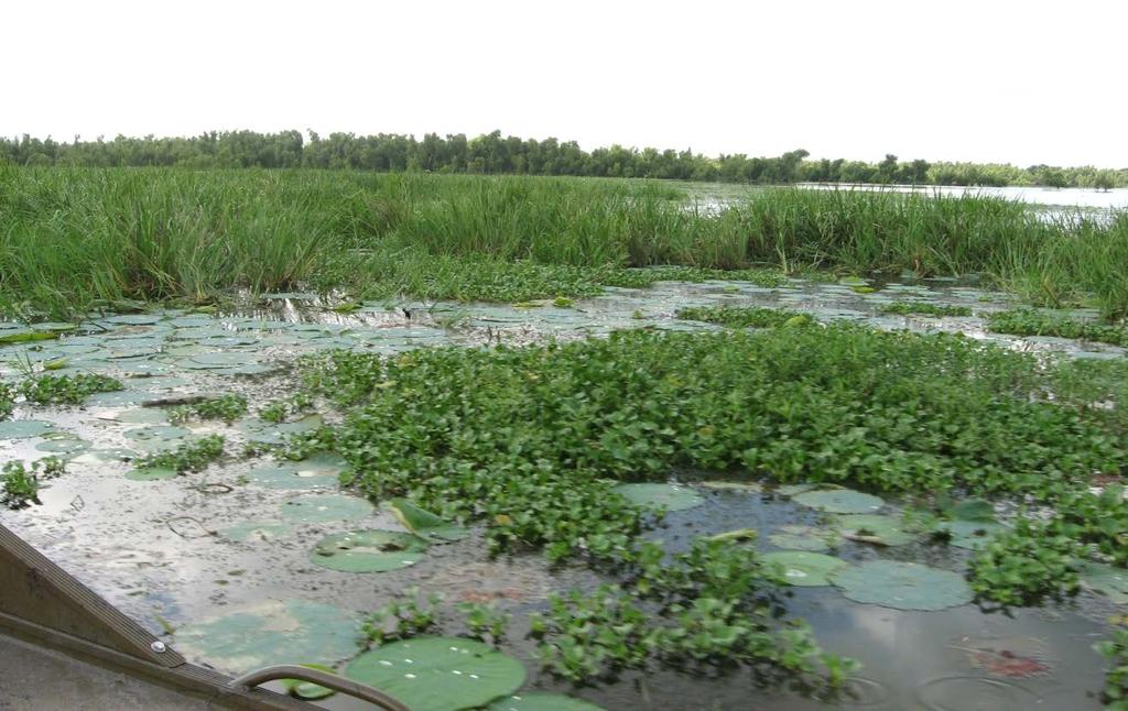
11 2002 Elevation and Vegetation Survey Effort An elevation and vegetation survey was conducted on Avoca Island Lake placement sites 5 and 5A during Site 5 A single transect (Transect #1) was oriented across Site 5 to cross areas where dredged material had been placed from 1981 through The average elevation of Site 5 was about +4.4 feet MLG. The majority of Site 5 was classified as wetland forest with elevations ranging from about +3.1 feet MLG to about 5.3 feet MLG. Dominant vegetation in this habitat was composed of black willow (Salix nigra) and Chinese tallow (Sapium sebiferum) trees with the groundcover composed primarily of willow-weed (Polygonum lapathifolium). Marsh habitat was found primarily at the lower elevation edges of Site 5. The dominant marsh vegetation was composed of southern cattail (Typha domingensis) and alligator weed (Alternanthera philoxeroides). Results of this survey effort revealed that dredging contractors had, at some point, exceeded the original placement elevation restrictions for Site 5. It is very likely that
12 these placement elevations were exceeded during the 1989 Bayou Chene bendway widening dredging. Site 5A Two transects were located across Site 5A such that they crossed areas where dredged material had been placed from 1988 to The first transect (Transect #2) crossed the more-or-less central, unforested portion of this site. The average elevation of this Site 5A transect was about +3.0 feet MLG and was dominated by marsh vegetation. Vegetation included water hyacinth (Eichhornia crassipes), pennywort (Hydrocotyle ranunculoides), southern cattail, alligator weed, willow-weed, arrow arum (Peltandra virginica), and black willow.
13 The second transect (Transect #3) was located across the forested eastern part of Site 5A. The average elevation of this Site 5A transect was about +3.9 feet MLG and classified as wetland forest habitat. Dominant vegetation was composed primarily of black willow and groundsel bush (Baccharis halimifolia). Marsh habitat was found along the lower elevation northern end of Site 5A.
14 Although there was no evidence that dredging contractors had exceeded dredged material placement elevations in Site 5A, it should be noted that 2001 elevations were not as low as had been anticipated during disposal design planning. A final average target elevation for these Avoca Island Lake placement sites, following compaction and dewatering of dredged material, was expected to be about +2.0 to +2.5 feet MLG.
BENEFICIAL USE OF DREDGED MATERIAL DISPOSAL HISTORY HOUMA NAVIGATION CANAL, LA
 BENEFICIAL USE OF DREDGED MATERIAL DISPOSAL HISTORY HOUMA NAVIGATION CANAL, LA 1991-2012 The Houma Navigation Canal (HNC) provides a navigation channel between Houma, Louisiana, and the Gulf of Mexico
Atchafalaya River and Bayous Chene, Boeuf, and Black, LA Disposal Area I Inspection. CEMVN-OD-T August 2011
 Atchafalaya River and Bayous Chene, Boeuf, and Black, LA Disposal Area I Inspection CEMVN-OD-T August 2011 Overview The CEMVN conducted an inspection of Disposal Area I on 4-August-2011 to investigate
Cat Island Chain Background & Access Guide
 Cat Chain Background & Access Guide Brown County Port & Resource Recovery Department 2561 S. Broadway, Green Bay, WI 54304 (920) 492-4950 www.portofgreenbay.com January 2018 1 Restoration of the Cat Chain
GALVESTON DISTRICT Dredging Schedules
 GALVESTON DISTRICT Dredging Schedules Christopher Frabotta Chief, Navigation Branch Southwestern Division - Galveston District November 2, 2016 Galveston District Dredging Meeting Custodians of the Texas
2012 Texas Water Conservation Association Meeting
 2012 Texas Water Conservation Association Meeting BG Thomas Kula Southwestern Division Commander 15 June 2012 US Army Corps of Engineers AGENDA UNCLASSIFIED Overview of Southwestern Division Missions Texas
MOBILE DISTRICT 2018 DREDGING PROGRAM
 MOBILE DISTRICT 2018 DREDGING PROGRAM SOUTH ATLANTIC DIVISION U.S. ARMY CORPS OF ENGINEERS Trusted Partners Delivering Value Today for a Better Tomorrow US Army Corps of Engineers BUILDING STRONG MOBILE
Engineering With Nature Geographic Project Mapping Tool (EWN ProMap)
") Engineering With Nature Geographic Project Mapping Tool (EWN ProMap) Cynthia Banks Program Manager Burton Suedel, PhD Research Biologist Michelle Bourne Research Biologist U.S. Army ERDC 23 June 2015 Dredging
Engineering With Nature Geographic Project Mapping Tool (EWN ProMap) Cynthia Banks Program Manager Burton Suedel, PhD Research Biologist Michelle Bourne Research Biologist U.S. Army ERDC 23 June 2015 Dredging
Proposed Cherry Grove Canals Dredging Project
 Proposed Cherry Grove Canals Dredging Project 1 Development of Cherry Grove C.D. Nixon inherited 9,940 acres of land 1924 Nixon family began planning subdivision of Cherry Grove 1950 Mr. Nixon closed natural
KP Lasnaya 1 River
 KP 370.2 Lasnaya 1 River The Lasnaya 1 River crossing is protected by Reno mattings and a gabion wall on the north bank (Photo 1). The south bank consists of natural river gravel deposits on top of Reno
U.S. Army Corps of Engineers Wilmington District
 U.S. Army Corps of Engineers Wilmington District 2012 East Coast - WEDA October 9-11, 2012 Ongoing & Upcoming Contracts US Army Corps of Engineers Wilmington District Ongoing Contracts Project Quantity
Buffalo District Navigation Program Overview
 Buffalo District Navigation Program Overview 16 FEB 2011 US Army Corps of Engineers Buffalo District Area of Operations Our Facilities District Headquarters 2 Area Offices 3 Regulatory Field Offices Lake
USACE GALVESTON DISTRICT PROJECT UPDATE
 USACE GALVESTON DISTRICT PROJECT UPDATE 255 255 255 237 237 237 0 0 0 217 217 217 163 163 163 200 200 200 DREDGE YOUR DOCKS 2018 131 132 122 239 65 53 80 119 27 110 135 120 252 174.59 112 92 56 62 102
Inner Harbor Navigation Canal Lock. Victor A. Landry III Operations Manager, GIWW New Orleans District U.S. Army Corps of Engineers
 Inner Harbor Navigation Canal Lock Victor A. Landry III Operations Manager, GIWW New Orleans District U.S. Army Corps of Engineers 22 August 2008 GIWW & IHNC Lock Overview Dewatering Challenges GICA 103
Riverine Sand Mining/Scofield Island Restoration (BA-40)
") Riverine Sand Mining/Scofield Island Restoration (BA-40) Conference on Ecological and Ecosystem Restoration Kenneth Bahlinger, CPRA Project Manager July 31, 2014 committed to our coast committed to our
Riverine Sand Mining/Scofield Island Restoration (BA-40) Conference on Ecological and Ecosystem Restoration Kenneth Bahlinger, CPRA Project Manager July 31, 2014 committed to our coast committed to our
Baltimore Harbor & Channels, Maryland and Virginia
 FACT SHEET January 2006 Type of Project: Navigation Project Phase: Operation & Maintenance Authorization: Section 101 of the River and Harbor Act of 1958 (42-Foot Project), Section 101 of the River and
Presented to: City of Petaluma City Council
 Agenda Item #1.A REVISED Presented to: City of Petaluma City Council Presented By: Dan St. John, F.ASCE, Director Jason Beatty, P.E., Senior Engineer James 'Jody' Boyette, USACE Project Manager November
Specification for Grip blocking using Peat Dams
 Technical Guidance Note 1 Specification for Grip blocking using Peat Dams 1. Introduction Moorland drains (grips) have been dug across much of the Yorkshire upland peatlands. Many of these grips have become
NC Dredge Studies. Sterling Baker, P.E. NCDOT James Gregson NCDEQ April 5, 2018
 NC Dredge Studies Study of the Use and Efficiency of the Dredge Manteo Study of Acquisition of Dedicated Dredging Capacity Study of Dredging Services Cost-Benefit Analysis Sterling Baker, P.E. NCDOT James
NC Dredge Studies NCBIWA Spring Conference April 23, 2018
 NC Dredge Studies Study of the Use and Efficiency of the Dredge Manteo Study of Acquisition of Dedicated Dredging Capacity Study of Dredging Services Cost-Benefit Analysis 2018 NCBIWA Spring Conference
Public Notice ISSUED: December 10, 2018 EXPIRES: January 9, 2019
 APPLICANT: REFER TO: St. Louis and Lake Counties Regional Rail Authority 2018-01942-ARC Public Notice ISSUED: December 10, 2018 EXPIRES: January 9, 2019 SECTION:404 - Clean Water Act 1. APPLICATION FOR
www: vermilionparishpolicejury.com
 www: vermilionparishpolicejury.com 1 Coastal Projects in Vermilion Parish Constructed over the last 26 years (CWPPRA, CIAP, State Surplus) PPL Number Project Name Project Types Current Estimate Acres
Florida Department of Environmental Protection Division of Recreation and Parks
 Florida Department of Environmental Protection Division of Recreation and Parks Land Honeymoon Island State Park Introduction Honeymoon Island State Park is a 2,810.16-acre public outdoor recreation and
Water Resources Update after NCGA Long Session
 Water Resources Update after NCGA Long Session North Carolina Beach Inlet & Waterway Association Annual Conference November 16, 2015 Division of Water Resources Overview New Name / Reorganization Jordan
Great Lakes Navigation System Dredging Update
 Great Lakes Navigation System Dredging Update Marie Strum U.S. Army Corps of Engineers Great Lakes Navigation Team June 3, 2015 US Army Corps of Engineers Great Lakes Dredging Team Annual Meeting Great
United States Department of the Interior National Park Service. Boundary Expansion Listed in National Register January 11, 2017
 NPS Form 10900-a (Rev. 8/2002) OMB No. 10240018 United States Department of the Interior National Park Service Boundary Expansion Listed in National Register January 11, 2017 National Register of Historic
Pinellas County Environmental Lands
 Pinellas County Environmental Lands In addition to traditional parks and recreation facilities, Pinellas County owns and manages a system of environmental lands that provides specialized resource-based
Manson Construction Co.
 Manson Construction Co. Since 1905 Frederick Paup, Chairman of the Board & Executive Vice President About Manson Established in 1905, Manson began as a small, family-owned Puget Sound marine pile driving
DRAFT. Dorabelle Campground Rehabilitation
 DRAFT Dorabelle Campground Rehabilitation September 2012 1.1 REGIONAL SETTING AND PROJECT LOCATION The Dorabelle Campground is located on the western shore of Shaver Lake in Fresno County, California (Section
Segment 2: La Crescent to Miller s Corner
 goal of the USFWS refuges is to conserve, protect and enhance fish, wildlife and plants and their habitats for the continuing benefit of the American people. Refuge lands are used largely for fishing,
Amended Maintenance Dredge Spoil Management Plan. Shute Harbour Marina Resort
 Amended Maintenance Dredge Spoil Management Plan Shute Harbour Marina Resort Amended Maintenance Dredge Spoil Management Plan Quality Information Document Ref Amended Maintenance Dredge and Spoil Maintenance
Cleveland Harbor Dredged Material Management
 Cleveland Harbor Dredged Material Management Requirements, Capacity Issues, and Placement Alternatives Brent R. Leslie, CPA Chief Financial Officer Cleveland-Cuyahoga County Port Authority Brent.Leslie@portofcleveland.com
SAME/SBA CONFERENCE. Col. Christopher W. Sallese Commander, Galveston District U.S. Army Corps of Engineers April 11, 2012
 SAME/A CONFERENCE Col. Christopher W. Sallese Commander, Galveston District U.S. Army Corps of Engineers April 11, 2012 U.S. Army Corps of Engineers Galveston District BUILDING STRONG 1 History of the
30 November Randall G. Hintz Chief, Operations Support Branch Operations Division. US Army Corps of Engineers BUILDING STRONG
 30 November 2011 Randall G. Hintz Chief, Operations Support Branch Operations Division US Army Corps of Engineers Overview MAINTENANCE PROJECTS Deep Draft Channels Shallow Draft Channels Coastal Inlets
Appendix C. Past and Current Management of Selected Tidal Wetland Sites
 Appendix C. Past and Current Management of Selected Tidal Wetland Sites Maps and photographs of wetland sites can be found at http://www.elkhornslough.org/tidalwetlandproject. Site 1. Parsons Slough/South
LAS VARAS RANCH CA COASTAL TRAIL PROPOSED ALIGNMENT
 LAS VARAS RANCH CA COASTAL TRAIL PROPOSED ALIGNMENT Santa Barbara Trails Council * Prepared by Ray Ford February 1,2012 The following notes accompany the Santa Barbara Trails Council map for the Las Varas
Kelly Motorized Trails Project Proposed Action
 Kelly Motorized Trails Project Proposed Action November 28, 2011 The Flagstaff Ranger District of the Coconino National Forest is seeking public input on the proposed Kelly Motorized Trails Project (formerly
Figure 7. Dragline at Cape Coral, Figure 8. Cape Coral oblique aerial photograph, 1959.
 The dredge-and-fill method, which would later be criticized for its environmental impact, employed in the peak years of the early 1960s as many as four dredges and ten draglines, which at times operated
4.0 Context for the Crossing Project
 4.0 Context for the Crossing Project This section provides background information about key features of the North Douglas Crossing project area, and opportunities and constraints. This information is important
Hydro-Electric Schemes Compliance Report June June 2013
 File Reference: 4.00212 Significance of Decision: Receives Only - No Decisions Report To: Operations, Monitoring and Regulation Committee Meeting Date: 20 June 2013 Report From: Nick Zaman, Pollution Prevention
STREAKED HORNED LARK. Conservation of a threatened species in an industrial landscape. Cat Brown US Fish and Wildlife Service
 STREAKED HORNED LARK Conservation of a threatened species in an industrial landscape Cat Brown US Fish and Wildlife Service HISTORICAL & CURRENT RANGE Streaked Horned Lark Distribution Historical Range:
TEXAS PORTS Value to the Nation
 TEXAS PORTS Value to the Nation Col. Christopher W. Sallese District Commander, Galveston District U.S. Army Corps of Engineers March 18, 2013 Houston-Galveston Area Council US Army Corps of Engineers
Region 1 Piney Woods
 Region 1 Piney Woods Piney Woods 1. This ecoregion is found in East Texas. 2. Climate: average annual rainfall of 36 to 50 inches is fairly uniformly distributed throughout the year, and humidity and temperatures
Appendix 4 St. Charles Basin
 Appendix 4 St. Charles Basin The St. Charles hurricane protection system (HPS), shown in Figure 1, was designed as part of the Lake Pontchartrain, LA, and Vicinity Hurricane Protection Project. The St.
Port Everglades Master/Vision Plan Update
 Port Everglades Master/Vision Plan Update Environmental Stakeholder Meeting June 15, 2009 Discussion to Focus On: Updating the 2006 Port Everglades Master Plan Issues dealing with the Turning Notch Potential
Appendix L Technical Memorandum Aesthetics
 Technical Memorandum Aesthetics 1.0 AESTHETICS This section provides a discussion of the aesthetic resources in the vicinity of ARTIC. Aesthetics pertain to the elements that make a certain view pleasing
Northern Rail Extension, Phase One
 General Project and Funding 1. Where does Phase One start? The rail line for Phase One begins roughly at the northern boundary of the former Bradbury property, but also includes work along Tom Bear Trail
Appendix N MAINTENANCE DREDGING STATEMENT OF NEED & PERMIT COMPLIANCE. North Thousand Islands Management Plan Appendices
 Appendix N MAINTENANCE DREDGING STATEMENT OF NEED & PERMIT COMPLIANCE North Thousand Islands Management Plan Appendices Maintenance Dredging Statement of Need & Permit Compliance The waterways, which consist
Triangle Land Conservancy Conservation Area Monitoring Report Carolina North
 Triangle Land Conservancy Conservation Area Monitoring Report Carolina North Property Name: Bolin Creek West Conservation Area Date of visit: March 16, 2017 County: Orange Property Type: Restrictive Covenants
GALVESTON DISTRICT O&M NAVIGATION MISSION & RESPONSE TO HURRICANE HARVEY
 GALVESTON DISTRICT O&M NAVIGATION MISSION & RESPONSE TO HURRICANE HARVEY 237 237 237 217 217 217 200 200 200 80 119 27 252 174.59 1 255 255 255 0 0 0 163 163 163 131 132 122 239 65 53 Christopher Frabotta
Town of Oakfield Agricultural and Farmland Protection Plan
 SECTION III COMMUNITY OVERVIEW A. Regional Setting / Location The Town of Oakfield is located in the northwestern portion of Genesee County. Located west of New York's Finger Lakes, the Town is uniquely
The Mississippi River Commission. History of the Management of the Mississippi River. US Army Corps of Engineers BUILDING STRONG
 The Mississippi River Commission History of the Management of the Mississippi River US Army Corps of Engineers US Army Corps of Engineers Presentation Outline Overview of Mississippi River History of Mississippi
- NEUTRAL. Savannah ORGIA PETER SALAMON MASTER OF URBAN DESIGN THESIS SAVANNAH COLLEGE OF ART AND DESIGN MAY 2015
 - NEUTRAL + RE δge Savannah ORGIA PETER SALAMON MASTER OF URBAN DESIGN THESIS SAVANNAH COLLEGE OF ART AND DESIGN MAY 2015 PANAMA CANAL EXPANSION THE CATALYST Suez 1869-6,000 km Panama 1914-13,000 km Prior
Recreational Impacts of Coastal Restoration Projects in Louisiana
 Recreational Impacts of Coastal Restoration Projects in Louisiana i National Conference on Ecosystem Restoration Baltimore, MD Joseph Berlin and Andrew Perez August 5, 2011 Recreational Impacts were Estimated
Friday, September 14, 2018
 Friday, September 14, 2018 American Currents Key Issues - Reduced tow sizes SB from St. Louis to Gulf by one string (5 barges) - Industry is tracking Hurricane Florence and the potential impact to the
TH E FIRST SEASON of investigations at the
 QUSEIR AL-QADIM Janet H. Johnson & Donald Whitcomb TH E FIRST SEASON of investigations at the ancient port of Quseir al-qadim on the Red Sea in Egypt took place in winter, 1978; the investigations were
Dungeness Recreation Area County Park Master Plan
 Dungeness Recreation Area County Park Public Outreach Meeting October 10, 2007 Project Overview USFWS Site Dungeness Recreation Area County Park Meeting Objectives: Re-Introduce project; provide status
Mr. Michael Malone CPS Energy 145 Navarro Street San Antonio, Texas Project No
 January 15, 2016 Mr. Michael Malone 145 Navarro Street San Antonio, Texas 78205 Project No. 0328985 Environmental Resources Management CityCentre Four 840 West Sam Houston Pkwy N. Suite 600 Houston, Texas
2018 Goldwedge Mines Inc. Licence of Occupation Management Plan. Photo: xxxx. Goldwedge Mines Inc.
 2018 2018 Goldwedge Mines Inc. Licence of Occupation Management Plan Photo: xxxx Goldwedge Mines Inc. March 2018 TABLE OF CONTENTS TABLE OF CONTENTS... i Figures... i 1. Background... 2 Project Overview...
The Galveston Seawall
 Coastal and Ocean Engineering ENGI.8751 Undergraduate Student Forum Faculty of Engineering and Applied Science, Memorial University, St. John s, NL, Canada. March, 2013 The Galveston Seawall Mark Harvey
State Five Year Tonnage Trend. Shipping Tons Receving Tons Within Tons Total Tons
 U.S. ARMY CORPS OF ENGINEERS Louisiana BUILDING STRONG 2015 State Quick Facts (Tons in Millions) Tons Shipped - 243.4 Tons Received - 238.8 Tons Shipped Within State - 53.7 Total Commerical Docks - 835
PLANNING COMMISSION MEETING MINUTES October 25, :00 p.m.
 PLANNING COMMISSION MEETING MINUTES 7:00 p.m. 1) Call to Order Commission members present: Chair Heck, Strandell, Warner, Sandholm, and Stulberg. Commission members absent: Pollmann, Watson. Staff present:
American Currents. Ohio/Tennessee/Cumberland. Chicago/Illinois/Upper Miss. Lower Miss/Gulf/Canals
 American Currents For additional details on the information noted below, please contact your ACBL Salesperson or Logistics Representative at (800) 899-7195 Ohio/Tennessee/Cumberland Chicago/Illinois/Upper
There are actually six geographic sub-regions, three in both the uplands and the lowlands.
 6 Regions of AR Although Arkansas is most easily divided into two distinct geographical regions, the northwestern uplands and the southeastern lowlands, this description does not accurately portray the
INTERNATIONAL BIRD STRIKE COMMITTEE Amsterdam, April 2000 PHOENIX RIO SALADO/TEMPE TOWN LAKE
 INTERNATIONAL BIRD STRIKE COMMITTEE IBSC25/WP-AV1 Amsterdam, 17-21 April 2000 PHOENIX RIO SALADO/TEMPE TOWN LAKE Paul Eschenfelder US Air Line Pilots Association, 16326 Cranwood, Spring, Texas 77379, USA
Railway-Highway Crossing at Grade Regulations: Guidelines for British Columbia s Provincial Heritage Railways
 Railway-Highway Crossing at Grade Regulations: Guidelines for British Columbia s Provincial Heritage Railways SHORT TITLE 1. These Guidelines may be cited as the Railway-Highway Crossing at Grade Guidelines.
Shrubs and alpine meadows represent the only vegetation cover.
 Saldur river General description The study area is the upper Saldur basin (Eastern Italian Alps), whose elevations range from 2150 m a.s.l. (location of the main monitoring site, LSG) and 3738 m a.s.l.
3.0 OVERVIEW OF HUECO BOLSON
 3.0 OVERVIEW OF HUECO BOLSON The Hueco Bolson covers about 2,500 square miles, or 1.6 million acres in New Mexico, Texas, and Chihuahua (Figure 3-1). In Texas, the Hueco overlies portions of El Paso and
Group similar facilities together separate dissimilar facilities.
 Park design Principle #1 Group similar facilities together separate dissimilar facilities. Why do we do this? Safety Differences in admission fees Differences in seasonal use Reduce user conflicts Principle
CORPS OF ENGINEERS ALASKA DISTRICT Dredging Projects. Michael Tencza, PE Operations Project Manager November 4, 2015
 CORPS OF ENGINEERS ALASKA DISTRICT 2016 Dredging Projects Michael Tencza, PE Operations Project Manager November 4, 2015 US Army Corps of Engineers Building and Preserving Alaska s Future AWARDED CONTRACTS
Section 61 Recreational Vehicle Park / Campground (Bylaw No. 2012/10)
") Part 7 General Regulations Section 61 Recreational Vehicle Park / Campground (Bylaw No. 2012/10) 61.1 A comprehensive site plan shall be provided to the satisfaction of the Development Authority that shows
Part 7 General Regulations Section 61 Recreational Vehicle Park / Campground (Bylaw No. 2012/10) 61.1 A comprehensive site plan shall be provided to the satisfaction of the Development Authority that shows
Yard Creek Provincial Park. Management Plan
 Yard Creek Provincial Park Management Plan Draft January 2010 Yard Creek Provincial Park Management Plan Approved by: telàlsemkin/siyam/chief Scott Benton Bill Williams Squamish Executive Director ation
Section 3-04 Cross Sectional Elements TABLE OF CONTENTS. INTRODUCTION...3 General...3 Exhibit 1-Cross-Sectional Elements...3
 Section 3-04 Cross Sectional Elements TABLE OF CONTENTS INTRODUCTION...3 General...3 Exhibit 1-Cross-Sectional Elements...3 CROSS-SECTIONAL ELEMENTS...3 Traveled Way...3 Shoulder...3 Surfacing Taper...3
Tuesday, March 12, 2019 RIVER CLOSURES & RESTRICTED MOVEMENTS
 Tuesday, March 12, 2019 American Currents Key Issues - Shoaling on the Tennessee Tombigbee River could have it closed until the second half of April - Tennessee River is closed around mile 440-450 until
HIGH COUNTRY L-BAR RANCH
 HIGH COUNTRY L-BAR RANCH Sandoval and mckinley counties N e w m e x i c o Jim Haworth, Ranch Team Lead Broker ~ 505-235-5236 3613 NMSR 528 NW, Ste. H, Albuquerque, NM 87114 505-792-3713 www.wwrealty.com
Describe the swamp in one word
 Describe the swamp in one word Misconceptions of the Swamp. There are many misconceptions and myths surrounding swamps. What came to mind when you heard the word swamp? Was it tales of Swamp Things or
Lake Wissota Access Locations within the LaFayette Township. By Chad Martin
 Lake Wissota Access Locations within the LaFayette Township By Chad Martin Anson/ Wissota Access Point # 1 Road: 195 th St. Associated Fire Numbers: 13294 Defining Characteristics: Forested from road
Figure 1 shows the evaluation area around Tailings Basin Cells 2E/1E. Two areas were evaluated for potential wetland impacts including:
 Barr Engineering Company 4700 West 77th Street Minneapolis, MN 55435-4803 Phone: 952-832-2600 Fax: 952-832-2601 www.barr.com An EEO Employer Minneapolis, MN Hibbing, MN Duluth, MN Ann Arbor, MI Jefferson
Great Lakes Waterways Conference
 Great Lakes Waterways Conference David Wright U.S. Army Corps of Engineers Chief of Operations Detroit District US Army Corps of Engineers Agenda FY14 Maintenance Dredging Key FY14 Needs/Projects Duluth-Superior
BLANKET CREEK PROVINCIAL PARK
 BLANKET CREEK PROVINCIAL PARK PURPOSE STATEMENT AND ZONING PLAN February 2003 BLANKET CREEK PROVINCIAL PARK Purpose Statement and Zoning Plan Primary Role The primary role of Blanket Creek Park is to maintain
SECTION 3 GENERAL DESCRIPTION OF THE RIVER BASIN
 SECTION 3 GENERAL DESCRIPTION OF THE RIVER BASIN SECTION 3 GENERAL DESCRIPTION OF THE RIVER BASIN River basin description. A general description of the river basin or subbasin, as appropriate, in which
Trail Phasing Plan. Note: Trails in the Clear Creek Canyon area (Segments will be finalized in the future to minimize wildlife impacts
 Note: Trails in the Clear Creek Canyon area (Segments 2 5 and a future JCOS connection) will be finalized in the future to minimize wildlife impacts Trail Phasing Plan P Parking 3 Easy Trail Intermediate
2.0 Physical Characteristics
 _ 2.0 Physical Characteristics 2.1 Existing Land Use for the Project The site is comprised of approximately 114 acres bounded by Highway 101 to the north, the existing town of Los Alamos to the east, State
CENTRAL Nebraska Public Power and Irrigation District
 415 Lincoln St. P.O. Box 740 Holdrege, NE 68949-0740 CENTRAL Nebraska Public Power and Irrigation District Phone: (308) 995-8601 Fax: (308) 995-5705 Web: www.cnppid.com Filed Electronically via FERC efiling
BENEFICIAL USE OF DREDGED MATERIAL PILOT PROGRAM
 SECTION 1122 OF WRDA 2016 1 BENEFICIAL USE OF DREDGED MATERIAL PILOT PROGRAM National Dredging Meeting June 13, 2018 The views, opinions and findings contained in this report are those of the authors(s)
Jason J. Hull, P.E. Director of Engineering. Port Freeport 1100 Cherry Street Freeport, Texas
 Jason J. Hull, P.E. Director of Engineering Port Freeport 1100 Cherry Street Freeport, Texas 77541 979.233.2667 hull@portfreeport.com Port Freeport s History Feb. 1913 Corps Hopper Dredge Comstock sank
DIVISION BULLETIN NO. 2
 OFFICE OF THE DIVISION ENGINEER CORPS OF ENGINEERS, MISSISSIPPI VALLEY DIVISION P.O. BOX 80, 1400 WALNUT STREET VICKSBURG, MS 39181 CEMVD-ET-CO February 2016 DIVISION BULLETIN NO. 2 NAVIGATION CONDITIONS
Wednesday, September 12, 2018
 Wednesday, September 12, 2018 American Currents Key Issues - Reduced tow sizes SB from St. Louis to Cairo by one string (5 barges) - Upper Miss at Lock 17 (UM 437) has reopened - Calcasieu Lock (WC 238)
Paper 1F and 3H: Decision-Making Exercise. Wednesday 4 June 2008 Morning Resource Booklet. Advance Information
 Paper Reference(s) 1313/1F and 3H Edexcel GCSE Geography B Paper 1F and 3H: Decision-Making Exercise Wednesday 4 June 2008 Morning Resource Booklet Advance Information Do not open before Wednesday 30 April
Chapter 7 Geography and the Early Settlement of Egypt, Kush, and Canaan
 Chapter 7 Geography and the Early Settlement of Egypt, Kush, and Canaan How did geography affect early settlement in Egypt, Kush, and Canaan? Section 7.1 - Introduction RF/NASA//Corbis This satellite photograph
Outreach Notice. FREMONT-WINEMA NATIONAL FOREST Zone Planning Staff GS Winter Rim Zone Paisley and Silver Lake Ranger Districts
 Outreach Notice FREMONT-WINEMA NATIONAL FOREST Zone Planning Staff GS-0401-11 Winter Rim Zone Paisley and Silver Lake Ranger Districts The Position This position is located on the Winter Rim Zone, Fremont-Winema
GILBERT & WEST TOWN INTERCOUNTY DRAIN Windsor Township, Eaton County and City of Lansing, Delhi Township, Ingham County, Michigan
 GILBERT & WEST TOWN INTERCOUNTY DRAIN Windsor Township, Eaton County and City of Lansing, Delhi Township, Ingham County, Michigan PRELIMINARY ENGINEERING REPORT Abigail Eaton, Chair Intercounty Drains
Theme: Predominately natural/natural appearing; rustic improvements to protect resources. Size*: 2,500 + acres Infrastructure**:
 Recreation Opportunity Spectrum (ROS) Classes The Recreation Opportunity Spectrum (ROS) provides a way to describe the variations in the degree of isolation from the sounds and influences of people, and
Rural Rustic Road Program
 Virginia Department of Transportation s Rural Rustic Road Program Prepared by the Local Assistance Division Virginia Department of Transportation 1401 East Broad Street Richmond, Virginia 23219 Michael
b. Minimum Site Area. Recreational vehicle parks shall be located on a parcel of land not less than 3 acres in area.
 6450 RECREATIONAL VEHICLE PARK REGULATIONS 6450 TITLE AND PURPOSE. The provisions of Section 6450 through 6499, inclusive, shall be known as the Recreational Vehicle Park Regulations. The purpose of these
Mississippi River & Tributaries Project History & Overview
 Mississippi River & Tributaries Project History & Overview Watershed Division Mississippi Valley Division 17 June 2015 US Army Corps of Engineers BUILDING STRONG Lake Texoma Spillway Tulsa Little Rock
CELEBRATE WEST GREENWICH GEOCACHING THROUGHOUT WEST GREENWICH
 CELEBRATE WEST GREENWICH GEOCACHING THROUGHOUT WEST GREENWICH The West Greenwich Land Trust (WGLT) is sponsoring Celebrate West Greenwich, an event designed to celebrate the beauty and history of scenic
CHAPTER 4 -- THE LAND USE PLAN: DESCRIPTIONS AND POLICIES FOR THIRTEEN PLANNING AREAS
 CHAPTER 4 -- THE LAND USE PLAN: DESCRIPTIONS AND POLICIES FOR THIRTEEN PLANNING AREAS NORTH CENTRAL CAC PLANNING AREA 4.4 FORT BRAGG CITY LIMIT TO HARE CREEK PLANNING AREA (Includes Noyo) The Noyo community
Challenges with recruiting small business for USCG Ship Repair Contracts in USCG District 8
 Challenges with recruiting small business for USCG Ship Repair Contracts in USCG District 8 LT. Erich D. Dix,USCG, Dr. Syed Adeel Ahmed College of Engineering, University of New Orleans, New Orleans, 70148,
Triangle Land Conservancy Conservation Area Monitoring Report Carolina North
 Triangle Land Conservancy Conservation Area Monitoring Report Carolina North Property Name: Bolin Creek East Conservation Area Date of visit: March 16, 2017 County: Orange Property Type: Restrictive Covenants
Subject to sale, withdrawal, or error.
 The Crawford L Bar Ranch is located approximately 40 air miles west of Albuquerque, New Mexico. This ranch truly epitomizes the description of New Mexico being the Land of Enchantment. The topography and