WEST DEEPING HERITAGE GROUP 22 ND SEPTEMBER Talk and presentation by. Rebecca Casa Hatton
|
|
|
- Blaze Cummings
- 5 years ago
- Views:
Transcription
1 WEST DEEPING HERITAGE GROUP 22 ND SEPTEMBER 2015 Talk and presentation by Rebecca Casa Hatton Rebecca Casa Hatton (MA, PhD) is Peterborough City Council Archaeologist. She has been in post since 2009, having previously worked as Historic Environment Record Officer at Peterborough City Council and Site Supervisor/Project Officer for Cambridgeshire County Council. Rebecca has a sound knowledge of the Peterborough area and Cambridgeshire as a whole, having worked on archaeological sites since During her archaeological career she has frequently been involved in outreach and education projects through the supervision of volunteers on many commercial archaeological sites, guided site tours, talks to local interest societies, supervision of university students and lectures at University Centre of Peterborough. 1
2 MEDIEVAL MAXEY Introduction Maxey is part of a landscape of national archaeological importance, which is focused on the gravel terraces of the Welland river system. Prior to the first systematic drainage and reclamation schemes in post-medieval times, several river channels meandered towards the fens, to create a wide river delta interspersed with low gravel islands. The solid geology consists of Oxford Clay and Kellaways Sand and Clay, overlain by drift deposits of river terrace sand and gravel. Around 10, 000 years ago the late Pleistocene (Devensian) - Early Holocene (Flandrian) saw the development of anastomosing channel system (two or more interconnected channels that enclose flood basins) in the Lower Welland Valley. Maxey occupied a strategic location, being situated on one of these gravel islands, with limestone to the south and the wet fenland to the east. The first settlers would have been able to inhabit and cultivate dry ground, harvest the fowl and fish of the wetlands, and use the pastures for seasonal grazing. Evidence suggests that occupation began in the Early Neolithic period, with a large number of ceremonial and ritual monuments dating from 4000 BC. Occupation continued throughout the Bronze Age, Iron Age, Roman and Anglo-Saxon periods. Neolithic Two cursus monuments, from the Latin for racecourse, long tracks or avenues with parallel banks and external ditches and closed at the either end by further banks and ditches. They may be some kind of processional way and are sometimes associated with long barrows. A causewayed enclosure, an enclosure with one or more irregular circuits of ditch interrupted by numerous gaps or causeways. Henge monuments, circular or near-circular enclosures defined by a ditch with outer bank, with either a single entrance or a pair of opposed entrances. They may have had a ritual function. Bronze Age Round barrows, circular burial mounds consisting of an earthen or earth and rubble domed structure often with a surrounding ditch and sometimes an outer bank. The mound would usually have covered inhumation or cremation remains on, or just below, the original ground surface. These are the most common prehistoric remains in Britain as individual barrows, or clustered together in barrow cemeteries. Most date from the early and middle Bronze Age period. Iron Age A pit alignment, a linear arrangement of pits, typical of the middle and later Bronze Age into the Iron Age in southern and central England, originally forming a boundary feature, probably in conjunction with the spoil dug from them raised up as a bank to one side. 2

3 3

4 4

 (HER 00624).")
5 King Street (Durobrivae Ancaster in Lincolnshire), a branch of Ermine Street (London - York), runs north-south through Maxey parish. (West Deeping has developed along this route). Lolham Bridges are located on this road, to the south of Lolham House. They are supposed to have been originally constructed by the Romans when they built the road. Lolham Bridges were built in the 17 th century. They consist of 5 bridges which do not go across a river but across meadows liable to flood (inscriptions of 1651 construction; inscription of repairs) (HER 00624). Aerial photograph: Lolham Bridges The Roman Car Dyke lies 2km to the north-east of the village. This water channel was traditionally thought to represent a Roman canal stretching from the River Witham to the Cam. It was proved to form part of a late 1st or early 2nd century fen drainage system. The dyke is not continuous, being interrupted at intervals by causeways, and functions as a catchwater system, diverting water from the uplands to the west into east-flowing streams. It has been suggested that the dyke may have acted as a boundary of an imperial Fen estate created under the Emperor Adrian in the early part of the 2 nd century 5

6 6
7 The Medieval Poly-focal Settlement Maxey is not mentioned in the Domesday Book of AD However, it is referred to as Macuseige in AD 965, meaning Macus (Scandinavian personal name) Island from the Old Norse ey ending, as Maxey village occupies a gravel islands. By the 12th century a number of knights were recorded as holding fees in Maxey. During the 13th and 14th centuries, land within the parish was held by Roger de Torpel, Robert de Corvill and Eleanor, Queen of England. Maxey, historically in the Soke of Peterborough, appears to have developed as a poly-focal settlement during the medieval period, with dispersed nuclei of occupation: The castle to the north (now known as Castle End). The outlying manorial centres at Lolham and Nunton (now marked by Lolham Hall and Nunton House, respectively), to the west. The hamlet of Deeping Gate to the east. Deeping Gate The hamlet of Deeping Gate is located to the north-east of Maxey, on the right bank of the River Welland. Is first recorded as Depynggate in 1390 meaning Road to Deeping (Old Norse Gata, meaning street ). By tradition, it has been associated with Maxey from the earliest times, and most of the land was held of the manor of Maxey. The Abbey of Peterborough had a toll at Deeping, which was repeatedly confirmed by royal charters. Nunton The hamlet of Nunton is first recorded as Nunnetun in 963 meaning Nunna s Farm. it was situated in the fields between Maxey Church and the low marshy land in the south of the parish. It comprised 11 taxpayers in 1301 and 1524, and had shrunk by c 1720 to 4 families. Slight disturbance is visible around Nunton House but there are no remains of desertion (HER 00638). Nunton House is a late 17th century Grade 2 Listed Building with 19th century alterations. Lolham The hamlet of Lolham, first recorded as Lehalm(e) in 1150 from the Old English hleo for protection and helm for cattle-shed, meaning sheltering shed, was located near the junction of King Street and the branch road to Maxey, where Lolham Hall stands. It comprised 12 taxpayers in 1301 and in 1377 it was taxed with Maxey and Nunton. In houses and 100 acres of arable land still survived. There were several different owners and in 1681 Fitzwilliam of Milton brought the manor. The settlement had shrunk by c to 1 family. Slight disturbance around Lotham Hall indicates possible desertion but there are no outstanding remains (HER 01014). Medieval pottery has been recovered in the general area. Lolham Hall is a late 15 th century Grade 2 listed Building with 18 th century alterations. During the 16 th and 17 th century the manor was held by the Claypoles who were related to Cromwell through marriage. It was then sold to the Fitzwilliams. 7
8 The Castle According to the sources, in 1374 a license was granted to Sir William de Thorpe, Chief Justice of the King s Bench, who owned land within the parish, to fortify the manor house at Castle End and convert it into a castle. Maxey Castle was originally a fortified moated manor house. In the 15th century Margaret, mother of Henry VII, is known to have lived there. The manor continued to be passed within the royal lineage until 1561, when Elizabeth I granted it to William Cecil (Lord Burghley). In 1625, it was sold to Lord Fitzwilliam and it has remained in the Fitzwilliam estate ever since. By the mid-16th century, English poet and antiquarian Leland reported that much of the castle was already in ruins. The Churches Church of St Peter The Church of St Peter was built to serve the needs of the hamlets of Lolham and Nunton; hence its location away from the core of the modern village. Built on an artificial mound, it was erected in the early 12 th century, as indicated by the tower, which is the oldest part of the building. However, fragments of tombstones excavated in the churchyard and preserved in the church indicate that a Saxon church may have existed on the current site. In addition, references are made to the church and Makesey Field in the 10 th century, and in 1013 the parish of Makesey, the manors and church are said to have laid to waste by the Danes. Accordingly, the church was repaired to allow worship to continue, until rebuilding began a century later. The building style is very similar to that of the Norman church at Castor (St. Kyneburgh), which was built around the same time, possibly by the same architect (HER 02242). Free Chapel of St Mary (Deeping Gate) Near the southern end of Deeping St. James Bridge is the site of the medieval free chapel of St. Mary known from historic and cartographic evidence. A free chapel was not subject to the jurisdiction of the ordinary, having been founded by the king or by a subject specially authorized. The chapel might have served the needs of Deeping Gate. It was founded by the Anable family between 1370 and Records show that it passed into the hands of the Cecil s at Burghley in A lease agreement from 1632 states all of which premises anciently belonged to the Chappell of Deepingate suggests that the Chapel no longer existed by this time. The O.S map series 1886 indicates the former chapel being located immediately south of the Old Black Bull P.H. There are no remains of this former chapel (HER 02254). Chapel of the Blessed Virgin (Castle End) The medieval chapel of the Blessed Virgin to the S of Maxey Castle at Castle End was extant in Its foundation is unrecorded. No remains of the chapel have been found and its site is unconfirmed. It is likely that the chapel was built to serve Castle End (HER 02251). 8
 archaeological")
9 Early Medieval (Anglo Saxon) archaeological evidence 9
10 The Layout from the Archaeology Early Medieval (Anglo-Saxon) There is little doubt that settlement and agriculture were well established at Maxey in later Saxon and Norman times. Recent archaeological excavations at Castle End and along West End Road have revealed well-preserved sequences of Early Medieval settlement remains dating from the Middle Saxon period (mid - 7 th century to mid - 9 th century). The distinctive locally-produced pottery found at Maxey lends its name to a type recorded throughout the region, the so-called Maxey Ware, AD , a medium-hard to hard fabric with the surface and core colours ranging from black through grey to red-brown. The clay was tempered with crushed shell and sand, vessels were coil-made with surfaces finished by washing, giving a soft soapy feel). In some parts of eastern England the transition to the Middle Saxon period was marked in the pottery sequence by the introduction of new handmade pottery traditions. The best known of these is Ipswich ware found throughout East Anglia and along the east coast. Southern Maxey ware is found in southern Lincolnshire, Cambridgeshire and Northamptonshire into Bedfordshire. Northern Maxey ware is found mainly in central and northern Lincolnshire. Examples were traded to York and Nottingham, all on navigable rivers. A Middle Saxon settlement was excavated in the 1960s to the west of the village, in advance of gravel extraction (OS Map of ). There were at least seven rectangular post-built structures and various boundary ditches and pits (HER 02175). Further evidence for Middle Saxon settlement was identified at Stepping Lane (HER 02159), where extensive deposits of pottery were found. At Lolham Hall several sherds of Anglo-Saxon pottery were retrieved (HER 02151a). Investigations carried out at 37 West End Street in 2009 identified a large Late Saxon pit containing early-mid 11th century pottery and a significant amount of cattle, horse and pig bones. These remains may possibly relate to the settlement in the Castle End area (HER and 52003). In 2010 an archaeological evaluation undertaken on land at Wisteria Farm revealed pits and ditches dating to the late Saxon and medieval periods (HER and 52261). The Coal Yard site excavated in 1999 produced evidence for occupation dating from the 11th to the 15th century, including a good assemblage of Stamford and developed Stamford ware. Occupation consisted of timber buildings and a series of deep quarry pits. During the early post-medieval period the site was levelled and returned to cultivation (HER 50591). An archaeological field evaluation undertaken at Willow Brook Farm in 2003 revealed surfaces, a hearth, stone walls, ditches, post holes, and pits, pointing to occupation from the Late Saxon period to the early post-medieval period along the street front on Castle End Road (HER 51250). Investigations at Lyndon Farm in 1997 revealed an extensive area of Roman settlement. Evidence for continuous occupation of the site into the early Anglo Saxon period comprised a dispersed collection of hand-made pottery that was recovered from pits, gullies, and post holes across the site. A fragment of loom weight, a bone needle, and red deer antler were also assigned an early Anglo Saxon date. The presence of a few sherds of Maxey Ware or St Neots ware indicated middle to late Saxon settlement in the vicinity. The furrows of medieval strip cultivation were identified across the site (HER and HER 51130). 10

11 Medieval archaeological evidence 11
12 Medieval During the medieval period settlement developed around the earlier foci, as suggested by investigations carried out at West End Road and Castle End. During investigations carried out at the rear of 19 West End Road in 2005 and 2006 several phases of activity were identified. Activity was consistent with continuous domestic occupation along the street frontage, dating from the 12 th century and spanning the whole of the medieval and post-medieval periods (PCC HER 51411). At Wisteria Farm the 2010 investigations revealed archaeological features dating to the late Anglo-Saxon and medieval periods. The latter was characterised by the presence of ditched rear plots and rubbish pits, confirming medieval settlement in this part of Maxey. The focus of medieval occupation lay along the West End Road with arable fields visible as a headland and ridge-furrow extending across the adjacent site at 37 West End Road to the rear (PCCHER 51658). The archaeological excavation undertaken at Willow Brook Farm during 2004 revealed evidence for Anglo-Saxon and medieval activity (pits, post holes and small ditches) within the backyards of properties along Castle End Road (an area focused on a large medieval moated site). The settlement declined between 1350 and PCCHER 51372). The Layout from the Maps Enclosure The Enclosure Map of 1819 shows the vestiges of the large manorial open fields, with names including Barr Dike Field, the Great Clay Field and South Field around the village. The remains of medieval strip fields survive in pasture as earthwork ridge and furrow. There are earthworks in pasture indicative of early quarrying, ponds, boundaries, lanes, and settlement, off Castle End Road, around the castle site, and at Nunton. These contrast with the smaller narrow closes of 1-2 acres situated around cottages and probably used to grow herbs and vegetables and secure stock. Medieval or early postmedieval long thin property plots are preserved in present boundaries running from the High Street, Castle End, and West End Road. The toft refers to the land on which the house was built, the croft is the adjoining plot of land used for pasture or arable. Generally seen as narrow parallel strips of land. The 18th and 19th century Enclosure caused many changes, including the re-routing of High Street from the south to the north of the church and the straightening of several boundaries. At this time road names changed, including Pound Lane becoming Castle End Road and Stepping Lane (deriving from the stepping stones) changing to West End Road. OS 1 st and 2 nd Editions The and Ordnance Survey map shows that Maxey was relatively untouched by Victorian development. The Congregational Chapel was built, farmyards expanded into courtyard complexes, and a few cottages constructed and others extended. However, the settlement would have been characterised by groupings of stone and thatched, and Collyweston stone slated buildings along narrow roads, with wide grass verges that were less regular and more open than today, incorporating bends and turns. 12
13 Post-War The village was still largely untouched by development until the Second World War when the first quarries were opened to provide aggregates for the airfields. Immediately after the war new houses were built, although it was the 1960s and 1970s that saw real change. During this period, a number of old cottages were demolished and replaced by infill houses. The great majority of these new homes were constructed in modern bricks with concrete roof tiles, so ending the tradition of stone, thatch and Collyweston slate that had been almost the only materials until the 20th century. 13

14 14
15 15
16 16
17 17

18 18
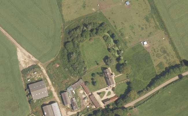
19 Maxey Castle List entry Number: Date first scheduled: 05-Jan-1995 PCCHER: Maxey Castle is located at Castle End, on the N edge of the village of Maxey. It represents a scheduled moated site with associated enclosures and a fishpond Around 6,000 moated sites are known in England. They consist of wide ditches, often or seasonally water-filled, partly or completely enclosing one or more islands of dry ground on which stood domestic or religious buildings. In some cases the islands were used for horticulture. The majority of moated sites served as prestigious aristocratic residences, with the provision of a moat intended as a status symbol rather than a practical military defence. The peak period during which moated sites were built was between about 1250 and 1350, and by far the greatest concentration lies in central and eastern parts of England. However, moated sites were built throughout the medieval period, are widely scattered throughout England and exhibit a high level of diversity in their forms and sizes. They form a significant class of medieval monument and are important for the understanding of the distribution of wealth and status in the countryside. The history of Maxey Castle is well documented and indicates that occupation was relatively short-lived. The castle is a late medieval moated site with outworks to the north and north east and an associated fishpond to the south east. A licence to fortify the moated manor was granted to William de Thorpe in By the mid-16th century, however, Leland observed that parts of the site were already ruinous. A 16th century illustration of the castle shows it with a tall central tower or keep and a number of earthwork banks, the outer flanked by a ditch parallel to the NE angle of the moat. The moated site includes a square central island, measuring 50m across, which is surrounded by a wet moat on the SW, NW, and NE sides. The remaining side, the SE, has been largely in-filled to the level of the external ground surface. Where the moat is open it is about 16m wide. The ditches have been cleared of silt recently using a machine, and the up-cast material dumped on the island. As a result, the ditches are now permanently wet. There is a counterscarp bank, between 6m and 10m wide, on the NW and NE sides of the moat. A 5m wide outlet channel at the E end of the SE side drains into the boundary ditch flanking the road. The area to the north of the moated enclosure contains a rare example of an outer courtyard surrounded by flood defences. The island and courtyard are likely to retain buried remains, including the foundations of buildings. The undisturbed section of the moat is likely to contain environmental, artefactual and ecofactual evidence related to the occupation of the site Two duck houses have been constructed in the moat. The extant Castle Farmhouse is a 15 th century Grade 2 Listed building with 17 th and 18 th century alterations. 19
20 20

21 21
22 References Victoria County History - Northants Gover, J.E.B., Mawer, A. & Stenton, F.M The Place-Names of Northamptonshire, English Place-Name Society, Cambridge University Press Hall, D Peterborough historic landscape; township boundaries, hedges and landuse, a report held at Peterborough Historic Environment Record to accompany draft characterisation maps. Peers, C The Victoria History of the County of Northamptonshire, (1906), 502 Peterborough Historic Environment Record Pryor, F Etton. Excavations at a Neolihic causewayed enclosure near Maxey, Cambridgeshire, , English Heritage Archaeological Report 18 Toulmin Smith, L.(ed.) The itinerary of John Leland in or about the years , Vol. Fol 5, 32 Maps Map of Maxey, Deeping, Gate, Glinton, Northborough, Peakirk, etc. [Henry VIII], Public Record Office MPI 251 A map of Maxey with Deepingate, undated but probably mid-18th century (NRO Map 1084) Enclosure Map of Maxey, Deeping, Northborough, Glinton, Peakirk and Helpston, 1819 Copy in Peterborough Central Library) Ordnance Survey Series,
Following the initial soil strip archaeology is sprayed up prior to planning and excavation
 Barton Quarry & Archaeology Over the past half century quarries have been increasingly highlighted as important sources of information for geologists, palaeontologists and archaeologists, both through
Archaeological Investigations Project South East Region SOUTHAMPTON 2/842 (C.80.C004) SU
 SU") SOUTHAMPTON City of Southampton 2/842 (C.80.C004) SU 4382 1336 125 BITTERNE ROAD WEST, SOUTHAMPTON Report on the Archaeological Evaluation Excavation at 125 Bitterne Road West, Southampton Russel, A. D
SOUTHAMPTON City of Southampton 2/842 (C.80.C004) SU 4382 1336 125 BITTERNE ROAD WEST, SOUTHAMPTON Report on the Archaeological Evaluation Excavation at 125 Bitterne Road West, Southampton Russel, A. D
FOUNDATIONS OF ARCHAEOLOGY A WALK IN VERNDITCH CHASE
 FOUNDATIONS OF ARCHAEOLOGY A WALK IN VERNDITCH CHASE 1. A Tale of two Long Barrows Long barrows were constructed as earthen or drystone mounds with flanking ditches and acted as funerary monuments during
Excavations in a Medieval Market Town: Mountsorrel, Leicestershire,
 Excavations in a Medieval Market Town: Mountsorrel, Leicestershire, by John Lucas Mountsorrel is situated 12 kms north of Leicester and forms a linear settlement straddling the A6, Leicester to Derby road.
Chiselbury Camp hillfort
 Chiselbury Camp hillfort Reasons for Designation Large univallate hillforts are defined as fortified enclosures of varying shape, ranging in size between 1ha and 10ha, located on hilltops and surrounded
Gorse Stacks, Bus Interchange Excavations Interim Note-01
 Gorse Stacks, Bus Interchange Excavations 2015 Prepared for: Cheshire West & Chester Council Interim Note-01 1 Introduction & Summary Background Since c. 2000 investigations associated with redevelopment
archeological site LOS MILLARES
 archeological site LOS MILLARES Aerial view of the plain of Los Millares between the Rambla de Huéchar and the River Andarax The archaeological site of Los Millares is located in the township of Santa
The Archaeology of Cheltenham
 The Archaeology of Cheltenham The archaeology collection of The Wilson contains a rich quantity of material relating to the prehistoric and Roman occupation of the North Cotswolds and parts of the Severn
South West Region GLOUCESTERSHIRE 1/405 (B.23.H005) SU
 SU") GLOUCESTERSHIRE Cotswold 1/405 (B.23.H005) SU 16559880 COTSWOLD EASTERN SPINE ROAD STAGE 4 Cotswold Eastern Spine Road Stage 4 and Horcott Road. Watkins, K Gloucester : Gloucestershire County Council Archaeology
GLOUCESTERSHIRE Cotswold 1/405 (B.23.H005) SU 16559880 COTSWOLD EASTERN SPINE ROAD STAGE 4 Cotswold Eastern Spine Road Stage 4 and Horcott Road. Watkins, K Gloucester : Gloucestershire County Council Archaeology
4. Bronze Age Ballybrowney, County Cork Eamonn Cotter
 4. Bronze Age Ballybrowney, County Cork Eamonn Cotter Illus. 1 Location map of the excavated features at Ballybrowney Lower (Archaeological Consultancy Services Ltd, based on the Ordnance Survey Ireland
East Midlands Region LEICESTER 3/16 (E.62.A010) SK
 SK") LEICESTER City of Leicester 3/16 (E.62.A010) SK 5853 0433 12 NEW ST., CASTLE WARD, LEICESTER Cottage to the Rear of 12 New St., Castle Ward, Leicester - A Photographic Survey and Archaeological Watching
LEICESTER City of Leicester 3/16 (E.62.A010) SK 5853 0433 12 NEW ST., CASTLE WARD, LEICESTER Cottage to the Rear of 12 New St., Castle Ward, Leicester - A Photographic Survey and Archaeological Watching
Wessex Archaeology. Little Stubbings, West Amesbury, Salisbury, Wiltshire. Archaeological Watching Brief. Ref:
 Wessex Archaeology Little Stubbings, West Amesbury, Salisbury, Wiltshire Ref: 63280.02 March 2007 LITTLE STUBBINGS, WEST AMESBURY, NR SALISBURY, WILTSHIRE ARCHAEOLOGICAL WATCHING BRIEF Prepared for: P
Land off Birdie Way, Rush Green, Hertford, Hertfordshire
 Land off Birdie Way, Rush Green, Hertford, Hertfordshire An Archaeological Evaluation for Bride Hall Development Limited by Sarah Coles Thames Valley Archaeological Services Site Code RGH00/ 01 January
Brenig Archaeology Trail
 Walk Information: Maps: OS Explorer 264 Distance: 2.5 miles / 4 kilometres Duration: Allow 2.5 hours for the circular walk Difficulty: easy. Well-marked trail over fields. Start and finish: SH 98325741
An archaeological evaluation at 14 Vineyard Street, Colchester, Essex March 2006
 An archaeological evaluation at 14 Vineyard Street, Colchester, Essex March 2006 report prepared by Ben Holloway commissioned by Colchester Borough Council CAT project code: 06/4b Colchester Museums accession
The Castor Roman Walk
 The Castor Roman Walk Welcome to the Route Plan and teachers notes for the Castor Roman Walk. The walk is approximately 3km, with an optional extension of 0.7km. We suggest that you bring with you OS Explorer
BRONZE AGE FIELD SYSTEM AT SOUTHAMPTON AIRPORT
 Proc. Hampshire Field Club Archaeol. Soc. 65, 2010, 1-6 (Hampshire Studies 2010) BRONZE AGE FIELD SYSTEM AT SOUTHAMPTON AIRPORT By J SULIKOWSKA With contributions by LORRAINE MEPHAM and CHRIS J STEVENS
Archaeological Observation at The Bishop s Palace, Alvechurch, Worcestershire
 Warwickshire County Council THE MOAT HOUSE Archaeological Observation at The Bishop s Palace, Alvechurch, Worcestershire Chris Jones and Bryn Gethin Report 1059 December 2010 The Moat House: Archaeological
Cholesbury New House, Parrots Lane, Cholesbury, Buckinghamshire
 Cholesbury New House, Parrots Lane, Cholesbury, Buckinghamshire An Archaeological Watching Brief For Mr Martin Wood by Sean Wallis Thames Valley Archaeological Services Ltd Site Code PLC 06/135 March 2007
An archaeological excavation at 193 High Street, Kelvedon, Essex September 2009
 An archaeological excavation at 193 High Street, Kelvedon, Essex September 2009 report prepared by Ben Holloway and Howard Brooks on behalf of Marden Homes CAT project ref.: 09/4g NGR: TL 8631 1913 (c)
Archaeological Investigations Project Yorkshire & Humberside Region NORTH YORKSHIRE 2/1113 (C.36.J002) SD
 SD") NORTH YORKSHIRE Craven 2/1113 (C.36.J002) SD 93607800 CRAY BECK, BUCKDEN, UPPER WHARFEDALE Cray Beck, The Archaeological Investigation of a Stone Feature Archetype Wensleydale : ArcheType Archaeological
NORTH YORKSHIRE Craven 2/1113 (C.36.J002) SD 93607800 CRAY BECK, BUCKDEN, UPPER WHARFEDALE Cray Beck, The Archaeological Investigation of a Stone Feature Archetype Wensleydale : ArcheType Archaeological
Archaeological Watching Brief at the Brick Stables and Wagon Lodge, Abbey Barns, Abbey Road, Faversham, Kent September 2010
 Archaeological Watching Brief at the Brick Stables and Wagon Lodge, Abbey Barns, Abbey Road, Faversham, Kent September 2010 SWAT. Archaeology Swale and Thames Archaeological Survey Company School Farm
CARLUNGIE EARTH HOUSE
 Property in Care (PIC) ID: PIC015 Designations: Scheduled Monument (SM90059) Taken into State care: 1953 (Guardianship) Last reviewed: 2004 HISTORIC ENVIRONMENT SCOTLAND STATEMENT OF SIGNIFICANCE CARLUNGIE
Addington Village Farm, Addington Village Road, London Borough of Croydon
 Addington Village Farm, Addington Village Road, London Borough of Croydon An Archaeological Desk-Based Assessment for Bewley Homes PLC by Steve Ford Thames Valley Archaeological Services Site Code ARC00/47
Manor Farm, Wilcot, Pewsey, Wiltshire
 Manor Farm, Wilcot, Pewsey, Wiltshire An Archaeological Evaluation for Mr W. Madiment by Helen Moore Thames Valley Archaeological Services Ltd Site Code MFP02/78 September 2002 Summary Site name: Manor
ARCHAEOLOGICAL S E R V I C E S. Phase 5, Grimsby Road, Cippenham, Slough, Berkshire. Archaeological Recording Action.
 T H A M E S V A L L E Y ARCHAEOLOGICAL S E R V I C E S Phase 5, Grimsby Road, Cippenham, Slough, Berkshire Archaeological Recording Action by Andy Taylor Site Code: GRC13/57 (SU 9493 7977) Phase 5, Eltham
Northamptonshire Archaeology
 Northamptonshire Archaeology A programme of archaeological observation, investigation and recording at St Andrews Church, Spratton, Northamptonshire Northamptonshire Archaeology 2 Bolton House Wootton
Archaeological Investigations Project East Midlands Region NORTHAMPTONSHIRE
 NORTHAMPTONSHIRE 2/92 (C.34.A002) WAKEFIELD LODGE Wakefield Lodge, Northamptonshire. Archaeological Walkover Survey Bashford, D & Croft, A Oxford : Oxford Archaeology, 2001, 15pp, figs, tabs, refs Work
FORMER COUNTY OF SOUTH YORKSHIRE
 FORMER COUNTY OF SOUTH YORKSHIRE Barnsley 3/1883 (E.04.6010) SE 36491121 4 CHURCH HILL, ROYSTON 4 Church Hill, Royston, South Yorkshire. Archaeological Watching Brief (Report No. 868) O'Neill, R Leeds
Archaeological Monitoring at Ham Farm, Ham Road, Faversham, Kent
 Archaeological Monitoring at Ham Farm, Ham Road, Faversham, Kent NGR: 601750.0mE 162695.0mN Site Code HAM/WB/12 Report for A.J. Bray SWAT ARCHAEOLOGY Swale and Thames Archaeological Survey Company The
Gors Lydan barrows and medieval huts
 Walk Information: Maps: OS Explorer 214 Distance: 5.5 miles / 9 kilometres Duration: 4.5 to 5 hours Difficulty: Easy. Good paths and no steep gradients Start and finish: SO 11977545 Walk summary The walk
U3A WALK Harby Hose. Route Summary. Route Overview. Description. Waypoints. Harby. Stuart Galloway
 U3A WALK Harby Hose Stuart Galloway Route Summary A circular walk taking in Harby, Hose and the Grantham Canal. Route Overview Category: Walking Length: 7.310 km / 4.57 mi Parking: Village Hall School
Archaeological Investigations Project Eastern Region. Essex 2/197 (C.22.F025) TL
 TL") Essex Braintree 2/197 (C.22.F025) TL 75502284 BLANDFORD HOUSE, 7 LONDON ROAD, BRAINTREE Blandford House, 7 London Road, Braintree, Essex Davis, E Chelmsford : Essex County Council Field Archaeology Unit,
Essex Braintree 2/197 (C.22.F025) TL 75502284 BLANDFORD HOUSE, 7 LONDON ROAD, BRAINTREE Blandford House, 7 London Road, Braintree, Essex Davis, E Chelmsford : Essex County Council Field Archaeology Unit,
Aylesbury Masonic Hall, Ripon Street, Aylesbury, Buckinghamshire
 Aylesbury Masonic Hall, Ripon Street, Aylesbury, Buckinghamshire An Archaeological Recording Action for Wakefield Building Services by Andrew Mundin Thames Valley Archaeological Services Ltd Site Code
Report on an archaeological watching brief at Thomas Lord Audley School, Monkwick, Colchester
 Report on an archaeological watching brief at Thomas Lord Audley School, Monkwick, Colchester July 2000 for WS Atkins Property Services Colchester Archaeological Trust 12 Lexden Road, Colchester, Essex
NORTH YORKSHIRE 2/1340 (C ) SE
 SE") NORTH YORKSHIRE Craven 2/1339 (C.36.6001) SD 97606975 SD 94507750 KILNSEY TO BUCKDEN WATER PIPELINE Kilnsey to Buckden Water Pipeline, North Yorkshire. Geophysical Survey (Report no. 841) Webb, A Leeds
NORTH YORKSHIRE Craven 2/1339 (C.36.6001) SD 97606975 SD 94507750 KILNSEY TO BUCKDEN WATER PIPELINE Kilnsey to Buckden Water Pipeline, North Yorkshire. Geophysical Survey (Report no. 841) Webb, A Leeds
South East Region SOUTHAMPTON 3/1050 (E.80.H006) SU
 SU") SOUTHAMPTON 3/1050 (E.80.H006) SU 43351328 16 HAWKESWOOD ROAD Report on the Archaeological Observations at 16 Hawkeswood Road, Bitterne Manor Russil, A & Smith, M Southampton : Southampton City Council
SOUTHAMPTON 3/1050 (E.80.H006) SU 43351328 16 HAWKESWOOD ROAD Report on the Archaeological Observations at 16 Hawkeswood Road, Bitterne Manor Russil, A & Smith, M Southampton : Southampton City Council
Pen Cerrig-calch prehistoric cairns
 Walk Information: Maps: OS Explorer OL13 Distance: 8 miles / 13 kilometres Duration: Allow at least 6 hours for the circular walk Difficulty: medium. Some narrow paths, occasionally rough underfoot Start
Scotland was transformed both
 LORDS AND LAIRDS Scotland was transformed both politically and physically in the 12th and 13th centuries. King David I encouraged Anglo-Norman and Flemish immigrants to settle in southern and eastern Scotland,
Archaeological Watching Brief on land at Alpha, Gore Road, Eastry, Kent July 2010
 Archaeological Watching Brief on land at Alpha, Gore Road, Eastry, Kent July 2010 SWAT. Archaeology Swale and Thames Archaeological Survey Company School Farm Oast, Graveney Road Faversham, Kent ME13 8UP
Afon Adda Refurbishment Bangor
 Afon Adda Refurbishment Bangor Archaeological Assessment Revised Report GAT Project No. 1876 Report No. 628 April 2006 Ymddiriedolaeth Archaeolegol Gwynedd Gwynedd Archaeological Trust Craig Beuno, Ffordd
An Assessment of Lower Boddington
 W An Assessment of Lower Boddington Design and Conservation Team Reviewed Winter 2017 Contents Introduction... 2 Origins and Archaeology... 3 Historic Development... 3 Plan Form... 3 Space and relationship
Deddington Castle, Oxfordshire: A Summary of Excavations *
 Deddington Castle, Oxfordshire: A Summary of Excavations 1977 1979* R.J. Ivens for Queen s University, Belfast, and DoE Between 1947 and 1951 Prof. E.M. Jope carried out a series of rescue excavations
Cadbury Hill. YCCCART Yatton, Congresbury, Claverham & Cleeve Archaeological Research Team
 YCCCART Yatton, Congresbury, Claverham & Cleeve Archaeological Research Team How old is it? Cadbury Hill The hill top of Cadbury-Congresbury has produced signs of activity in Neolithic and Bronze Age times
ROUKEN GLEN: BANDSTAND 2015 DATA STRUCTURE REPORT
 ROUKEN GLEN: BANDSTAND 2015 DATA STRUCTURE REPORT Author (s) Ian Hill Editors Report Date June 2015 Working Partners Funders Phil Richardson East Renfrewshire Council East Renfrewshire Council, Heritage
An archaeological watching brief on land adjacent to 50 Rosebery Avenue, Colchester, Essex May/June 2003
 An archaeological watching brief on land adjacent to 50 Rosebery Avenue, Colchester, Essex May/June 2003 report prepared by C Crossan on behalf of Highfield Homes Ltd NGR: TM 0035 2500 CAT project ref.:
Neale Wade Community. College, March Cambridgeshire. Desktop Assessment. Client: Cambridgeshire County Council. March 2009
 Neale Wade Community Desktop Assessment Desktop Assessment College, March Cambridgeshire March 2009 Client: Cambridgeshire County Council OA East Report No: 1095 OASIS No: Oxfordar3-56453 NGR: TL 417 952
Investigations at Jackdaw Crag Field, Boston Spa, SE , in by Boston Spa Archaeology and Heritage Group
 0 Investigations at Jackdaw Crag Field, Boston Spa, SE 42304632, in 2006-7 by Boston Spa Archaeology and Heritage Group www.bostonspaheritage.co.uk Preface and Summary This report records the results of
6 Results of NMP mapping
 6 Results of NMP mapping 6.1 Overview of results In general terms the nature of archaeological evidence available from aerial photographs determines the types of site recorded as part of NMP. Usually these
WALKS AROUND WOODHURST
 WALKS AROUND WOODHURST With Walks To Woodhurst from North St. Ives Woodhurst is situated on the verge of an elevated tract of table land four miles north of St. Ives. Its footpaths vary from leafy lanes
Scheduled Monument (SM90085) Taken into State care: 1966 (Guardianship) Last reviewed: 2004 CROOKSTON CASTLE
 Taken into State care: 1966 (Guardianship) Last reviewed: 2004 CROOKSTON CASTLE") Property in Care (PIC) ID: PIC119 Designations: Scheduled Monument (SM90085) Taken into State care: 1966 (Guardianship) Last reviewed: 2004 HISTORIC ENVIRONMENT SCOTLAND STATEMENT OF SIGNIFICANCE CROOKSTON
Property in Care (PIC) ID: PIC119 Designations: Scheduled Monument (SM90085) Taken into State care: 1966 (Guardianship) Last reviewed: 2004 HISTORIC ENVIRONMENT SCOTLAND STATEMENT OF SIGNIFICANCE CROOKSTON
The History of a Floodplain Meadow Bridget Smith
 The History of a Floodplain Meadow Bridget Smith I have lived in the village of Hemingford Grey near the River Great Ouse since 1976 and, like many others, walked the 1½ km into St Ives by the ancient
South West DORSET 3/1305 (E ) SY
 SY") DORSET East Dorset 3/1305 (E.19.6510) SY 93008000 COGDEAN ELMS, CORFE MULLEN Archaeological Watching Brief at Cogdean Elms, Corfe Mullen, Dorset (Doc.no.00.28) Manning, P T Exeter : Exeter Archaeology,
DORSET East Dorset 3/1305 (E.19.6510) SY 93008000 COGDEAN ELMS, CORFE MULLEN Archaeological Watching Brief at Cogdean Elms, Corfe Mullen, Dorset (Doc.no.00.28) Manning, P T Exeter : Exeter Archaeology,
Chetwode. HISTORIC LANDSCAPE REPORT / June 2011
 Chetwode Buckinghamshire Archaeological Society HISTORIC LANDSCAPE REPORT / June 2011 Report BAS/2011-05. Compiled by Karen Pepler, from a survey by Karen Pepler, Gary Marshall and Peter Marsden, with
South East SOUTHAMPTON
 Southampton SOUTHAMPTON 3/1056 (E.80.M010) SU 44181114 SO19 7PE 1 FOREST VIEW, SOUTHAMPTON Report on the Archaeological Watching Brief at 1 Forest View, Southampton, SOU 1232 Leivers, M Southampton : Southampton
Downton, Wiltshire: archaeology and history (notes for visitors prepared by the Royal Archaeological Institute, 2017)
") Downton, Wiltshire: archaeology and history (notes for visitors prepared by the Royal Archaeological Institute, 2017) The River Avon leaves Wiltshire in Downton, a large parish that includes parts of the
Downton, Wiltshire: archaeology and history (notes for visitors prepared by the Royal Archaeological Institute, 2017) The River Avon leaves Wiltshire in Downton, a large parish that includes parts of the
SUFFOLK 2/415 (C ) TM
 TM") SUFFOLK Babergh 2/415 (C.42.6001) TM 03254360 LADY LANE, INDUSTRIAL ESTATE, HADLEIGH Lady Lane Industrial Estate, Hadleigh. A Report on an Archaeological Evaluation (2000/66) Meredith, J Ipswich : Suffolk
SUFFOLK Babergh 2/415 (C.42.6001) TM 03254360 LADY LANE, INDUSTRIAL ESTATE, HADLEIGH Lady Lane Industrial Estate, Hadleigh. A Report on an Archaeological Evaluation (2000/66) Meredith, J Ipswich : Suffolk
TH E FIRST SEASON of investigations at the
 QUSEIR AL-QADIM Janet H. Johnson & Donald Whitcomb TH E FIRST SEASON of investigations at the ancient port of Quseir al-qadim on the Red Sea in Egypt took place in winter, 1978; the investigations were
The Landscape Archaeology of Martin Down
 The Landscape Archaeology of Martin Down Martin Down and the surrounding area contain a variety of well preserved archaeological remains, largely because the area has been unaffected by modern agriculture
Hay Wood, Rowington and Baddesley Clinton - Warwickshire
 Hay Wood, Rowington and Baddesley Clinton - Warwickshire Starts at Lay-by alongside Hay Wood 2 hours 30 minutes 5.5miles 8.8km Leisurely ID: 0.683 Developed by: John Clift Checked by: Andy Page www.ramblersroutes.org
In 2014 excavations at Gournia took place in the area of the palace, on the acropolis, and along the northern edge of the town (Fig. 1).
.") Gournia: 2014 Excavation In 2014 excavations at Gournia took place in the area of the palace, on the acropolis, and along the northern edge of the town (Fig. 1). In Room 18 of the palace, Room A, lined
Gournia: 2014 Excavation In 2014 excavations at Gournia took place in the area of the palace, on the acropolis, and along the northern edge of the town (Fig. 1). In Room 18 of the palace, Room A, lined
West Midlands Region SHROPSHIRE 3/1475 (E.39.H014) SO
 SO") SHROPSHIRE Bridgenorth 3/1475 (E.39.H014) SO 60828916 DITTON PRIORS CHURCH A Watching Brief at Ditton Priors Church Hannaford, H Shrewsbury : Shropshire County Council Archaeology Service, 2002, 1p An
SHROPSHIRE Bridgenorth 3/1475 (E.39.H014) SO 60828916 DITTON PRIORS CHURCH A Watching Brief at Ditton Priors Church Hannaford, H Shrewsbury : Shropshire County Council Archaeology Service, 2002, 1p An
Woodland Walk If you enjoyed this walk there are two others available in the same area.
 The Woodland Walk 11-12 kilometres (7-8 miles) 4-5 hours Terrain: some easy hills Can be slippery when wet 5 stiles Unsuitable for a pushchair/wheelchair Uses OS map 197 Parking: Pulborough Station and
Archaeological Investigations Project Eastern Region ESSEX 2/225 (C.22.A016) TL
 TL") ESSEX Braintree 2/225 (C.22.A016) TL 8280 1680 LAND NORTH-WEST OF RIVENHALL OAKS GOLF COURSE, FOREST ROAD, WITHAM Land North-West of Rivenhall Oaks Golf Course, Forest Road, Witham, Essex. Archaeological
ESSEX Braintree 2/225 (C.22.A016) TL 8280 1680 LAND NORTH-WEST OF RIVENHALL OAKS GOLF COURSE, FOREST ROAD, WITHAM Land North-West of Rivenhall Oaks Golf Course, Forest Road, Witham, Essex. Archaeological
South East Region MILTON KEYNES 3/951 (E.66.H019) SP
 SP") MILTON KEYNES 3/951 (E.66.H019) SP 48892517 100/102 HIGH STREET, OLNEY 100/102 High Street, Olney, Milton Keynes Lisboa, I Milton Keynes : Archaeologica, 2002, 23pp, figs, tabs, refs An archaeological
MILTON KEYNES 3/951 (E.66.H019) SP 48892517 100/102 HIGH STREET, OLNEY 100/102 High Street, Olney, Milton Keynes Lisboa, I Milton Keynes : Archaeologica, 2002, 23pp, figs, tabs, refs An archaeological
Quaker Meeting House, Sidcot. Oakridge Lane, Sidcot, Winscombe, Somerset, BS25 1LT. National Grid Reference: ST Statement of Significance
 Quaker Meeting House, Sidcot Oakridge Lane, Sidcot, Winscombe, Somerset, BS25 1LT National Grid Reference: ST 42930 57474 Statement of Significance A meeting house of 1817, much altered in the 1860s and
CHESHIRE HISTORIC TOWNS SURVEY
 CHESHIRE HISTORIC TOWNS SURVEY Eddisbury Archaeological Assessment 2003 CHESHIRE HISTORIC TOWNS SURVEY Eddisbury Archaeological Assessment 2003 Environmental Planning Cheshire County Council Backford Hall
The Sand House A Victorian Marvel
 The Sand House A Victorian Marvel A talk given by Richard Bell to Tickhill & District Local History Society in April 2007 The majority of Doncaster s 21st Century residents are oblivious to the unique
Pottery from Test-pits at Histon and Impington 14/15 May 2016
 Pottery from Test-pits at Histon and Impington 14/15 May 2016 Paul Blinkhorn The following pottery types were noted: BB: Brill/Boarstall Ware, c. AD1200-1600 (Mellor 1994). BD: Bourne D Ware, c. 1450-1637
THE HEUGH LINDISFARNE
 LINDISFARNE COMMUNITY ARCHAEOLOGY THE HEUGH LINDISFARNE Archaeological excavations in June 2017 Invitation to volunteers THE HEUGH, LINDISFARNE, NORTHUMBERLAND: ARCHAEOLOGICAL EXCAVATIONS 2017 INTRODUCTION
A428 Cambourne to Cambridge Better Bus Journeys. Landscape & Planning Appraisal Study Area. Key. Study Area. Westwick. Oakington.
 Westwick Boxworth Lower Gate Caldecote Highfields Cambridge Crow End Croft Newtown Roman Hill Harlton Source: Esri, DigitalGlobe, GeoEye, Earthstar Haslingfield Geographics, CNES/Airbus DS, USDA, USGS,
Document History continued Revision: Date: Prepared by: Checked by: Approved by: Reason for Issue:
 Document History continued Revision: Date: Prepared by: Checked by: Approved by: Reason for Issue: 1.0 29/10/2013 Gary Evans Andy Shelley Richard Brown For Acceptance Fieldwork Report CRL Ltd, 2014 Fieldwork
Desk Based Assessment
 DRAFT Land to the south-east of St Mary's Church Brampton Huntingdonshire Desk Based Assessment February 2010 Client: Savills OA East Report No: 1161 OASIS No: Oxfordar3-72032 NGR: TL 2150 7060 Desk Based
Archaeological Watching Brief Report
 Belvedere Nurseries Fenny Stratford Nr Milton Keynes Buckinghamshire Archaeological Watching Brief o oa a June 2006 Client Name: Goodsons Associates on behalf of Dobbies Garden Centre PLC Issue N o : 1
An archaeological watching brief on a new cable trench at the Abbey Field sports pitches, Circular Road North, Colchester, Essex October 2006
 An archaeological watching brief on a new cable trench at the Abbey Field sports pitches, Circular Road North, Colchester, Essex report prepared by Ben Holloway on behalf of Atkins Defence CAT project
Amarna Workers Village
 Amarna Workers Village The Egyptian city of Amarna was the pet building project of the pharaoh Akhenaten, who oversaw construction of his new capital between 1346 and 1341 BCE. The city was largely abandoned
A FIELDWALKING PROJECT AT HOLLINGBURY, BRIGHTON. by JOHN FUNNELL
 Introduction A FIELDWALKING PROJECT AT HOLLINGBURY, BRIGHTON by JOHN FUNNELL Members of the Brighton and Hove Archaeological Society walked the field at Hollingbury during the months of December 1991 and
History. Origins. Evolution
 2. History Origins The location of Newbald is at the Spring Line where the Chalk sits on top of impervious clay ensuring a plentiful supply of fresh water and energy to drive mills; this must have been
COSTOCK. Location and boundaries. is bounded to the north by Bunny, to the east by Wysall, to the south by Rempstone and to the west
 VCH Nottinghamshire On-line Texts in Progress This version: January 2013 Author: Sheila Leeds COSTOCK Location and boundaries The ancient parish of Costock occupies 1,688 acres 1 about 9½ miles south of
Trench 91 revealed that the cobbled court extends further to the north.
 Report on the 2013 Gournia Excavations The 2013 excavations at Gournia were conducted June 17 July 26 under the aegis of the American School of Classical Studies at Athens and the supervision of the KD
Provincial Archaeology Office Annual Review
 2017 Provincial Archaeology Office Annual Review Provincial Archaeology Office Department of Tourism, Culture, Industry and Innovation Government of Newfoundland and Labrador March 2018 Volume 16 A brief
Eglwyseg Mountain a landscape of prehistoric cairns and later industry
 Eglwyseg Mountain a landscape of prehistoric cairns and later industry Walk Information: Maps: OS Explorer 256 Distance: 5.3 miles / 8.5 kilometres (linear) or up to 9.6 miles / 15.5 kilometres (circular)
The Greek-Swedish-Danish Excavations at Kastelli, Khania 2010 a short report
 The Greek-Swedish-Danish Excavations at Kastelli, Khania 2010 a short report During six weeks from 19 July to 27 August the Greek-Swedish-Danish Excavations continued work in the Ag. Aikaterini Square
Vision for Kirkholt. Our proud history. From ancient knights to Victorian landmarks
 Vision for Kirkholt Our proud history From ancient knights......to Victorian landmarks Take the family heritage trail to discover historical gems on your doorstep See map inside FREE STICKERS! The Vision
An archaeological excavation and watching brief at the Musket Club, Homefield Road, Colchester, Essex December 2004-February 2005
 An archaeological excavation and watching brief at the Musket Club, Homefield Road, Colchester, Essex December 2004-February 2005 report prepared by Howard Brooks on behalf of RMPA and the MoD CAT project
Friends Meeting House, Leicester. 16 Queens Road, Leicester, LE2 1WP. National Grid Reference: SK Statement of Significance
 Friends Meeting House, Leicester 16 Queens Road, Leicester, LE2 1WP National Grid Reference: SK 59852 02815 Statement of Significance A meeting house purpose-built on a new site in 1955 and slightly enlarged
ESSEX 2/281 (C ) TL
 TL") ESSEX Braintree 2/281 (C.22.6034) TL 85342302 CHURCH OF ST PETER AD VINCULA, COGGESHALL A Report on an Archaeological Evaluation at the Church of St Peter ad Vincula, Coggeshall, Essex Brooks, H Colchester
ESSEX Braintree 2/281 (C.22.6034) TL 85342302 CHURCH OF ST PETER AD VINCULA, COGGESHALL A Report on an Archaeological Evaluation at the Church of St Peter ad Vincula, Coggeshall, Essex Brooks, H Colchester
BRONZE-AGE FOOD VESSEL (b) USED AS A BURIAL URN BROWN CANDOVER, [To face page 249]
![BRONZE-AGE FOOD VESSEL (b) USED AS A BURIAL URN BROWN CANDOVER, [To face page 249]](/thumbs/93/118018967.jpg "BRONZE-AGE FOOD VESSEL (b) USED AS A BURIAL URN BROWN CANDOVER, [To face page 249]") BRONZE-AGE FOOD VESSEL (b) USED AS A BURIAL URN BROWN CANDOVER, HANTS [To face page 249] 249 TWO BRONZE AGE DISCOVERIES IN HANTS. BY S. E. WlNBOLT, M.A. (i.) Brown Candover. East of the road at Brown Candover,
BRONZE-AGE FOOD VESSEL (b) USED AS A BURIAL URN BROWN CANDOVER, HANTS [To face page 249] 249 TWO BRONZE AGE DISCOVERIES IN HANTS. BY S. E. WlNBOLT, M.A. (i.) Brown Candover. East of the road at Brown Candover,
2. 4 Avebury: stone circles and nearby sites
 24 2. 4 Avebury: stone circles and nearby sites N E W S Beckhampton Avenue The bank originally stood 7 m (23 ft) high, much taller than today. The ditch was originally 9 m (30 ft) deep and 20 m (65 ft)
The Roman Rural Settlement Project
 The Roman Rural Settlement Project Preliminary results from the East Midlands Dr Tom Brindle Crown Copyright/database right 2013. The East Midlands dataset 544 records of LIA/Roman sites 15% of Jeremy
Archaeological Evaluation Report
 Holywell House Osney Mead Oxford o a November 2007 Client: Knowles and Son Issue N o : 1 OA Job N o : 3826 Planning Ref N o : 02/01800/FUL NGR: SP 502 055 Client Name: Knowles and Son Client Ref No: Document
Antinoupolis. Ongoing Destruction. Pre-2006 crops. Modern cemetery covering. ancient cemetery. Antinoupolis, ancient city. North cemetery (ancient).
.") Antinoupolis Ongoing Destruction Ongoing Destruction North cemetery (ancient). Pre-2006 crops Modern cemetery covering ancient cemetery. Antinoupolis, ancient city. Modern village of el Sheikh Abada Nile
Antinoupolis Ongoing Destruction Ongoing Destruction North cemetery (ancient). Pre-2006 crops Modern cemetery covering ancient cemetery. Antinoupolis, ancient city. Modern village of el Sheikh Abada Nile
Appendix 6 Scheduled Ancient Monuments in Wealden
 Appendix 6 Scheduled Ancient s in Wealden The following list is an extract from the Register of Scheduled Ancient s prepared by English Heritage. These sites are shown on the Proposals Map. Ancient monuments
Friends Meeting House, Warwick. 39 High Street, Warwick, CV34 4AX. National Grid Reference: SP Statement of Significance
 Friends Meeting House, Warwick 39 High Street, Warwick, CV34 4AX National Grid Reference: SP 28071 64737 Statement of Significance Warwick Meeting House has exceptional heritage significance as a fine
The Coach House, Mill Lane, Cookham, Berkshire
 The Coach House, Mill Lane, Cookham, Berkshire An Archaeological Watching Brief For Ms Sophia Butler by Stephen Hammond Thames Valley Archaeological Services Ltd Site Code CMC 03/104 October 2003 Summary
Wheatlands House, Fleet Hill, Finchampstead, Berkshire
 Wheatlands House, Fleet Hill, Finchampstead, Berkshire An Archaeological Watching Brief For JCA International by James McNicoll-Norbury Thames Valley Archaeological Services Ltd Site Code WFF 08/26 August
Looking north from the SW shieling site with Lub na Luachrach in the foreground
 Looking north from the SW shieling site with Lub na Luachrach in the foreground Upper Gleann Goibhre - Shieling sites Two shieling sites in the upper reaches of the Allt Goibhre were visited and recorded
DEFENCE AREA 73 FRESHWATER BAY
 DEFENCE AREA 73 FRESHWATER BAY 1. Area details: The defence area is 3½ miles from The Needles and 10 miles W of Newport. County: Isle of Wight. Parish: Freshwater. NGR: centre of area, SZ 346860. 1.1 Area
Street Sweeper Dump Site, RAF Lakenheath ERL 160
 ARCHAEOLOGICAL MONITORING REPORT Street Sweeper Dump Site, RAF Lakenheath ERL 160 A REPORT ON THE ARCHAEOLOGICAL MONITORING, 2006 (Planning app. no. F/2006/0021/GOV) Jo Caruth Field Team Suffolk C.C. Archaeological
S E R V I C E S. Land at Wyeth Pharmaceuticals, Huntercombe Lane South, Taplow, Berkshire. An archaeological recording action.
 T H A M E S V A L L E Y ARCHAEOLOGICAL S E R V I C E S Land at Wyeth Pharmaceuticals, Huntercombe Lane South, Taplow, Berkshire An archaeological recording action By Daniel Bray WLS12/150 (SU 9339 8088)