CHESHIRE HISTORIC TOWNS SURVEY
|
|
|
- Henry Parrish
- 5 years ago
- Views:
Transcription

1 CHESHIRE HISTORIC TOWNS SURVEY Eddisbury Archaeological Assessment 2003
2 CHESHIRE HISTORIC TOWNS SURVEY Eddisbury Archaeological Assessment 2003 Environmental Planning Cheshire County Council Backford Hall Backford Chester CH1 6PZ These reports are the copyright of Cheshire County Council and English Heritage. We would like to acknowledge the assistance of Cheshire and Chester Archives and Local Studies, Frodsham and District Local History Group, Winsford Local History Society, Andrew Fielding, Lion Salt Works Project Director and Dr Chris Lewis, University of Liverpool, in the preparation of these reports. The archive is held by the Cheshire County Sites and Monuments Record. The Ordnance Survey mapping within this document is provided by Cheshire County Council under licence from the Ordnance Survey, in order to fulfil its public function to make available Council held public domain information. The mapping is intended to illustrate the spatial changes that have occurred during the historical development of Cheshire towns. Persons viewing this mapping should contact Ordnance Survey copyright for advice where they wish to licence Ordnance Survey mapping/map data for their own use. The OS web site can be found at
3 EDDISBURY ARCHAEOLOGICAL ASSESSMENT Mike Shaw & Jo Clark 1 SUMMARY Strictly speaking Eddisbury does not qualify, and never has qualified, as a town. However, it is included in the survey of Cheshire s Historic Towns because it was the site of a burh (a defended centre) in the early 10th century. Such sites were often created as, or grew into, trading centres and are therefore an important example of early urbanism in Cheshire. The burh occupied the Iron Age hill fort known as Castle Ditches, which is located towards the northern end of the Mid Cheshire Ridge. Watling Street, the Roman road that connected Chester with Manchester and beyond, passes immediately below the fort. During the medieval period Eddisbury was the site of a hunting lodge. 1.1 Topography And Geology Eddisbury Hill, the site of the hillfort and burh, lies c 16km east of Chester and 0.5km west of Delamere on the Mid-Cheshire Ridge at 150m AOD, rising to 158m AOD in the north-west. The underlying geology comprises Keuper Waterstones (Geological Survey of Great Britain, 1965); and the soils in this area are typical brown sands, which are suited to both arable and grassland and are graded class 2 (Furness, 1978, 73). The A556 to Northwich runs 1km to the south of Eddisbury Hill and the B5152 runs 0.5km east of Eddisbury Hill to Frodsham. 1.2 Administrative Unit Eddisbury was included in the parish of Delamere, which was created from the last remaining part of the Delamere Forest, that was enclosed in 1812 and no tithes were payable on this land (Dunn 1987, 27). It lay in Eddisbury Hundred, which was in existence by , and Frodsham Deanery (ibid 14). Today Eddisbury lies within the Civil Parish of Delamere and the Borough of Vale Royal. 1.4 Place Name Eddisbury is first recorded in the Anglo-Saxon Chronicle of 914 as Eades byrig meaning Ead s stronghold. The place name also occurs as Edesberie (1086), Edersbury (1387) and Edusbury (1468) (Dodgson 1971, 213). 1
4 2 SOURCES 2.1 Historical Sources include the Anglo-Saxon Chronicle, Varley s excavation report in the Transactions of the Historical Society of Lancashire and Cheshire (1950), a brief description in Ormerod s History of County Palatine and City of Chester (1882), and 19th-century trade directories. 2.2 Cartographic Eddisbury is marked on Saxton s map of Cheshire (1577) as the Chamber in the Forest and on Speed s map of Cheshire (1610) as the Chamber Olim [once] Edesbury. The chamber depicted by these maps refers to a medieval hunting lodge. The only maps to show Eddisbury in detail before the OS First Edition 6 : 1mile map of 1874 are the plans of the Enclosure Award dated to , upon which the Chamber in the Forest and associated buildings are depicted. 2.3 Archaeological Two records from the County Sites and Monuments Record (CSMR) are located within Eddisbury, which are identified in Figure 1. Throughout this document, where sites and finds have been identified from the CSMR, the relevant reference has been provided. The present survey has not identified any new records. Eddisbury hillfort and burh were subject to extensive excavation by W J Varley from The results of this work and a discussion of the background to the site, including documentary evidence, are contained in the excavation report (Varley 1950). However, the archive and finds from the work have been largely lost but what little remains of this, has been deposited with the National Monuments Record (pers comm Adrian Havercroft). The site was the subject of a detailed earthwork survey in 1987 by the Royal Commission on the Historical Monuments (Cocroft et al 1989) 3 HISTORICAL AND ARCHAEOLOGICAL SUMMARY 3.1 Prehistoric A large number of important finds and sites are known in the vicinity of Eddisbury and it was obviously an area of some importance from at least the Neolithic period. Within a 2.5km radius at least ten stone axes of Neolithic to Bronze Age date (CSMR 834, 842, 843, 910, 2680/0/1) have been discovered, as well as a number of Bronze Age burial mounds (CSMR 835, 923). From the Iron Age period the chief monuments, apart from the hillfort, are two promontory forts, at Kelsbarrow (CSMR 833) 3km south-west, and Oakmere (CSMR 848), 2.75km south-east. Evidence of settlement on Eddisbury itself comes from Varley s 1930s excavations. He distinguished three phases of prehistoric activity, all dated to the Iron Age: Phase 1 a defensive palisade; Phase 2 construction of the original hillfort as a small 2
5 univallate (single-bank and ditched) enclosure around the eastern side of the hill; and Phase 3, an enlarged bivallate (double bank and ditched) enclosure (Varley 1950, 52). Varley s interpretations and dating have been challenged. Palisaded enclosures are now recognised as Late Bronze Age, perhaps 9th-8th century, rather than Iron Age in date and recently it has been suggested that he was wrong to suggest that there was a univallate phase to the hillfort (Cocroft et al 1989). Nevertheless it is clear that Eddisbury, as the largest hillfort in Cheshire, potentially represents an important regional Iron Age centre. In 1976 the OS recorded that the inner rampart on the north-east side was 15m wide, 6m high internally, 4m high internally with an inner ditch 10m wide and 0.5m deep. The outer rampart is 16m wide, 2m high internally and 5.5m high externally with no external ditch (OS Record Card SJ56NE1; CSMR 866/1). Much of the site has been damaged by ploughing, with traces of ridge and furrow evident in the interior of the fort. 3.2 Roman The hillfort lay close to the Roman road system: Watling Street (CSMR 844) passes around 100m to the south and this meets the road that connected Chester and Middlewich (CSMR 1017) 2km to the west. Varley s excavations of the hillfort revealed that the Romans had made a thorough job of the dismantling of Eddisbury. The south-eastern section was blocked and sealed, every ditch filled up, and the ramparts levelled to within a foot or so of their foundations (Varley 1950, 57). 3.3 Early Medieval Varley s excavations uncovered evidence of perhaps two phases of re-occupation of the site before the refurbishment of its defences. A series of circular sunken-floored huts with stone kerbs were found to have been built over the ruined inner rampart, and Varley suggested a date of the 4th to 6th century AD for this activity, which precedes the construction of the burh. The excavations revealed a further hut, said to be of wattle and daub and apparently oval in shape, within the upper silts of the inner ditch, for which Varley suggested a later, 6th to 8th century date, based on the recovery of an annular clay loom weight from the floor of the hut (Varley 1950, 12,) The Burh Evidence for the foundation of a burh or fortification at Eddisbury comes from both documentary and archaeological evidence. Documentary reference to the burh is contained in the Anglo-Saxon Chronicle: 3
6 In this year, God granting, Aethelflaed, lady of the Mercians, went with all the Mercians to Tamworth and built the burgh there in the early summer; and therefore the following Lammas (August 1) that at Stafford. Then in the year after this, that at Eddisbury, in the early summer; and afterwards in the same year, towards the end of Autumn, that at Warwick. (Varley 1950, 2) Varley s excavations demonstrated that the rebuilt portions of the inner and outer ramparts of the hillfort were later than the Dark Age huts over which they lie and although no associated artefacts were recovered, the only suitable context for such a rebuilding is the construction of the Aethelflaedan burh, which was recorded in the Mercian Register (Varley 1950, 61). The foundation of the burh at Eddisbury in 914 can be seen as part of a scheme for the protection of the Kingdom of Mercia by Aethelflaed, lady of the Mercians. Its purpose was to protect Mercia from the Northumbrian Danes based at York. Raiders might approach from the east along Watling Street or from the River Mersey to the north. This phase of burh foundation by Aethelflaeda saw the construction of fortresses at Bridgnorth in 912, Tamworth and Stafford in 913, Warwick as well as Eddisbury in 914, and Chirbury and Runcorn in 915. It can be seen that many of these fortifications were founded at centres which were either already proto-urban centres or were soon to become such. However, it is unlikely that this had ever been the intention at Eddisbury and certainly there is no evidence of any long-lasting occupation of the site. Occupation presumably lasted as long as necessary to carry out the refurbishment of the defences (assuming these were completed) and whilst it was strategically important. Higham (1988, 204) has argued that once Derby was captured in 917 and certainly once the burh at Manchester had been founded in 919 the burh at Eddisbury would have become obsolete. Higham has also pointed out that there is a second Eddisbury in Cheshire, near Rainow (Higham 1988, 202; 1993, 111). However, the archaeological evidence and the strategic position of the Delamere Eddisbury leaves little doubt that this is the Eddisbury to which the Chronicle refers Domesday In the Domesday Survey (1086), Eddisbury was described as waste both before and after the Conquest: The same Earl (Earl Hugh) [holds] Edesberie. Godwin held it as a free man. There [are] 2 hides that pay geld. The land is for 6 ploughs. It was and is waste. This land is 1 league long and as much wide. (Harris and Thacker 1987, 346) 3.4 Medieval The Manor At Domesday Eddisbury was part of the lands of the Earl of Chester and was incorporated into the extensive Forest of Delamere, which by the 14th century 4
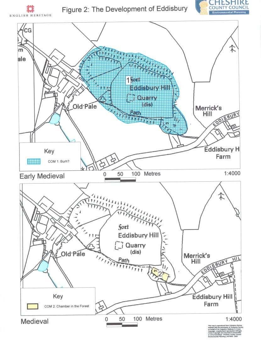
7 stretched from the River Gowy in the west to the River Weaver in the east and from Frodsham in the north to Beeston in the south The Chamber in the Forest Eddisbury lay in the heart of the Forest of Delamere and was from the 14th century the site of a forest lodge, known as the Chamber in the Forest. The lodge was the residence of the chief keepers of the forest, the Done family and their descendants, the Ardernes, until the enclosure of the Forest of Delamere in There are a number of references to repairs and rebuilding of the forest lodge from the 15th to 17th centuries (Varley 1950, 63-67). Varley s excavations uncovered the remains of the forest lodge buildings and he has suggested a sequence of occupation from 1350 to 1800 (Varley 1950, 67, Fig 18). The lodge was confined to a small area at the south-east corner of the fort, described on the OS First Edition 6 : 1 mile map as Merrick s Hill or the Chamber (John Merrick was the last tenant of the lodge). This and the earlier enclosure award map also show the outline of the lodge buildings. The hillfort has been subject to quarrying, as identified on the OS 6 : 1 mile map of This is then identified as an Old Quarry on the OS 25 : 1 mile map and as disused on the modern OS map. 3.5 Post Medieval The Chamber in the Forest was abandoned after the enclosure award of Eddisbury Hill Farm immediately east of the fort was already in existence at this time for it is shown on the Enclosure Map but Old Pale Farm, which lies immediately west of the earthworks dates from between 1819 and 1874, when it appears on the First Edition OS map. 4 PLAN COMPONENTS EARLY MEDIEVAL c (Figure 2) COM 1 - Burh? MEDIEVAL c (Figure 2) COM 2 - Chamber in the Forest 4.1 Early Medieval (Figure 2) Although activity can be traced back to the Neolithic period, and that the size and complexity of the Iron Age hillfort suggest that it was potentially a regional centre, the plan components commence with the early medieval burh. However, the burh is thought to have occupied the full extent of the Iron Age hillfort, andtherefore the hillfort and burh are both depicted as COM 1. 5
8 There is no evidence that there was any settlement on Eddisbury Hill immediately prior to the creation of the burh in AD 914. Presumably the positioning of the burh here was due to its strategic location and the existence of fortifications which could be refurbished with relative ease. However, the duration of the burh is likely to have been short, with suggestions that it was obsolete c AD Medieval (Figure 2) After the burh, the site appears to have fallen out of use until the establishment of the Chamber in the Forest (hunting lodge) in the Forest of Delamere, which persisted into the post medieval period. The lodge was located on a separate spur at the east end of the hillfort and is identified as COM 2. 5 HISTORICAL & ARCHAEOLOGICAL POTENTIAL 5.1 Above-Ground Remains Eddisbury hillfort is a Scheduled Ancient Monument (SAM 25692). The defences of the hillfort and burh are well preserved. However, the site has obviously been affected by plough damage (denuding of banks etc.), which may have had an adverse affect upon any surviving features within the hillfort/burh. Also a quarry was sited within the hillfort, which will have had an adverse effect upon any archaeology in this area of the site. The foundations of the Chamber in the Forest at the east end of the site survived as ruins before Varley s excavations, and the plans of the buildings are depicted on the Enclosure Award and OS First Edition maps. This area is now rough grassland. 5.2 Below-Ground Remains Varley s excavations have demonstrated good survival of the fort s defences. Features can be expected to survive in the interior below the plough levels. The extent to which the buildings of the Chamber in the Forest survive after Varley s excavations is unknown. He makes no mention of the removal of the buildings to examine earlier levels, so their foundations may survive. 6 PRIORITIES FOR ARCHAEOLOGICAL WORK 6.1 Introduction The research priorities for Eddisbury focus upon the early medieval period and its use as a burh. 6.2 Iron Age Establish the nature and extent of Iron Age activity at Eddisbury Examine the relationship of the hillfort with the surrounding landscape Examine Varley s archive and reassess his interpretation of the site 6
9 6.3 Roman Examine evidence of Roman reuse of the site Establish whether there is evidence of Roman destruction of the defences as Varley suggests. 6.4 Early Medieval Establish the nature and extent of early medieval settlement predating the creation of the burh Establish the nature and extent of the burh. Establish the function of the burh. Examine whether there is any evidence of internal features Establish the nature of its defences Establish for how long was it in use Establish whether it was a short-lived garrison or if there is any evidence of it having other functions (industrial etc) 6.5 Medieval Examine the foundation of the Chamber in the Forest and its development 6.6 Post Medieval Establish when the Chamber fell into disuse 7 SOURCES 7.1 Bibliography Cheshire County Council 1992 Cheshire State of the Environment: Technical Report on Physical Resources. Cocroft W D, Everson P, Jecock M and Wilson-North, W R 1989 Castle ditch hillfort, Eddisbury, Cheshire, reconsidered: the excavations of in the light of recent field survey in From Cornwall to Caithness. Some Aspects of British Field Archaeology. Papers presented to Norman V. Quinnell British Archaeological Reports British Series 209 CSMR, County Sites and Monuments Record, Environmental Planning, Cheshire County Council Dodgson, J McN, 1971 The Place-Names of Cheshire: Part lll - The Place-Names of Nantwich Hundred and Eddisbury Hundred, Cambridge University Press Dunn, F I, 1987 The Ancient Parishes, Townships and Chapelries of Cheshire Furness, R R, 1978 Soils of Cheshire Soil Survey Bulletin No.6 7
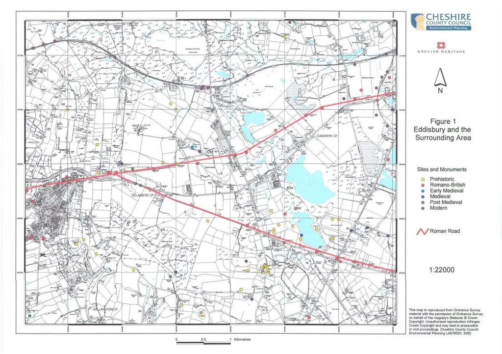
10 Harris, B E, (ed), 1979 The Victoria History of the County of Chester: Vol ll Oxford University Press Harris, B E and Thacker, A T (eds), 1987 The Victoria History of the County of Chester: Vol l Oxford University Press Higham, N J, 1988 The Cheshire burhs and the Mercian frontier to 924, Transactions of the Lancashire and Cheshire Antiquarian Society 85, Higham, N J, 1993 The Origins of Cheshire Manchester University Press Ormerod, G, 1882 The History of the County Palatine and City of Chester, 3 vols, 2nd edition, edited by Thomas Helsby Varley, W J, 1950 Excavations on the castle ditch, Eddisbury, , Transactions of the Historic Society of Lancashire and Cheshire, 102, Maps (CRO Cheshire Record Office) Geological Survey of Great Britain, 1 inch to 600 feet, Sheet 109: Chester- Drift, 1965 Enclosure Award 1819 (CRO QDE 1/23) Ordnance Survey First Edition 6 : 1mile Map Sheet 40, surveyed 1874 Plan of Delamere forest 1817 (CRO DTM 94) Saxton, C, 1577 Cestriae Comitatus (CRO PM 12/10) Speed, J, 1662 The County Palatine of Chester with the Most Ancient Citie Described (reprint of the 1610 original) (CRO PM1/11) 8 ILLUSTRATIONS Figure 1: Eddisbury and the Surrounding Area Figure 2: The Development of Eddisbury 8
11 9
12 10
CHESHIRE HISTORIC TOWNS SURVEY
 CHESHIRE HISTORIC TOWNS SURVEY Lymm Archaeological Assessment 2003 CHESHIRE HISTORIC TOWNS SURVEY Lymm Archaeological Assessment 2003 Environmental Planning Cheshire County Council Backford Hall Backford
CHESHIRE HISTORIC TOWNS SURVEY
 CHESHIRE HISTORIC TOWNS SURVEY Tarporley Archaeological Assessment 2003 CHESHIRE HISTORIC TOWNS SURVEY Tarporley Archaeological Assessment 2003 Environmental Planning Cheshire County Council Backford Hall
CHESHIRE HISTORIC TOWNS SURVEY
 CHESHIRE HISTORIC TOWNS SURVEY Frodsham Archaeological Assessment 2003 CHESHIRE HISTORIC TOWNS SURVEY Frodsham Archaeological Assessment 2003 Environmental Planning Cheshire County Council Backford Hall
Aylesbury Masonic Hall, Ripon Street, Aylesbury, Buckinghamshire
 Aylesbury Masonic Hall, Ripon Street, Aylesbury, Buckinghamshire An Archaeological Recording Action for Wakefield Building Services by Andrew Mundin Thames Valley Archaeological Services Ltd Site Code
Cholesbury New House, Parrots Lane, Cholesbury, Buckinghamshire
 Cholesbury New House, Parrots Lane, Cholesbury, Buckinghamshire An Archaeological Watching Brief For Mr Martin Wood by Sean Wallis Thames Valley Archaeological Services Ltd Site Code PLC 06/135 March 2007
Henderson Mess, RAF Halton, Buckinghamshire
 Henderson Mess, RAF Halton, Buckinghamshire An archaeological watching brief for Stepnell Ltd by Stephen Hammond Thames Valley Archaeological Services Ltd Site Code RHA03/85 October 2003 Summary Site name:
Gorse Stacks, Bus Interchange Excavations Interim Note-01
 Gorse Stacks, Bus Interchange Excavations 2015 Prepared for: Cheshire West & Chester Council Interim Note-01 1 Introduction & Summary Background Since c. 2000 investigations associated with redevelopment
ARCHAEOLOGICAL S E R V I C E S. Phase 5, Grimsby Road, Cippenham, Slough, Berkshire. Archaeological Recording Action.
 T H A M E S V A L L E Y ARCHAEOLOGICAL S E R V I C E S Phase 5, Grimsby Road, Cippenham, Slough, Berkshire Archaeological Recording Action by Andy Taylor Site Code: GRC13/57 (SU 9493 7977) Phase 5, Eltham
Chiselbury Camp hillfort
 Chiselbury Camp hillfort Reasons for Designation Large univallate hillforts are defined as fortified enclosures of varying shape, ranging in size between 1ha and 10ha, located on hilltops and surrounded
The Old Shire Horse Centre, Bath Road, Woolley Green, Maidenhead, Berkshire
 The Old Shire Horse Centre, Bath Road, Woolley Green, Maidenhead, Berkshire An Archaeological Watching Brief For Mr Derek Chesterman by Andrew Mundin Thames Valley Archaeological Services Ltd Site Code
Holyport Manor Special School, Highfield Lane, Cox Green, Maidenhead, Berkshire
 Holyport Manor Special School, Highfield Lane, Cox Green, Maidenhead, Berkshire An Archaeological recording action For CgMs Consulting by Jennifer Lowe Thames Valley Archaeological Services Ltd Site Code
Following the initial soil strip archaeology is sprayed up prior to planning and excavation
 Barton Quarry & Archaeology Over the past half century quarries have been increasingly highlighted as important sources of information for geologists, palaeontologists and archaeologists, both through
Wheatlands House, Fleet Hill, Finchampstead, Berkshire
 Wheatlands House, Fleet Hill, Finchampstead, Berkshire An Archaeological Watching Brief For JCA International by James McNicoll-Norbury Thames Valley Archaeological Services Ltd Site Code WFF 08/26 August
Addington Village Farm, Addington Village Road, London Borough of Croydon
 Addington Village Farm, Addington Village Road, London Borough of Croydon An Archaeological Desk-Based Assessment for Bewley Homes PLC by Steve Ford Thames Valley Archaeological Services Site Code ARC00/47
CHESHIRE HISTORIC TOWNS SURVEY
 CHESHIRE HISTORIC TOWNS SURVEY Knutsford Archaeological Assessment 2003 CHESHIRE HISTORIC TOWNS SURVEY Knutsford Archaeological Assessment 2003 Environmental Planning Cheshire County Council Backford Hall
Land off Birdie Way, Rush Green, Hertford, Hertfordshire
 Land off Birdie Way, Rush Green, Hertford, Hertfordshire An Archaeological Evaluation for Bride Hall Development Limited by Sarah Coles Thames Valley Archaeological Services Site Code RGH00/ 01 January
The Archaeology of Cheltenham
 The Archaeology of Cheltenham The archaeology collection of The Wilson contains a rich quantity of material relating to the prehistoric and Roman occupation of the North Cotswolds and parts of the Severn
The Coach House, Mill Lane, Cookham, Berkshire
 The Coach House, Mill Lane, Cookham, Berkshire An Archaeological Watching Brief For Ms Sophia Butler by Stephen Hammond Thames Valley Archaeological Services Ltd Site Code CMC 03/104 October 2003 Summary
An archaeological evaluation at 14 Vineyard Street, Colchester, Essex March 2006
 An archaeological evaluation at 14 Vineyard Street, Colchester, Essex March 2006 report prepared by Ben Holloway commissioned by Colchester Borough Council CAT project code: 06/4b Colchester Museums accession
South West Region GLOUCESTERSHIRE 1/405 (B.23.H005) SU
 SU") GLOUCESTERSHIRE Cotswold 1/405 (B.23.H005) SU 16559880 COTSWOLD EASTERN SPINE ROAD STAGE 4 Cotswold Eastern Spine Road Stage 4 and Horcott Road. Watkins, K Gloucester : Gloucestershire County Council Archaeology
GLOUCESTERSHIRE Cotswold 1/405 (B.23.H005) SU 16559880 COTSWOLD EASTERN SPINE ROAD STAGE 4 Cotswold Eastern Spine Road Stage 4 and Horcott Road. Watkins, K Gloucester : Gloucestershire County Council Archaeology
Northamptonshire Archaeology
 Northamptonshire Archaeology A programme of archaeological observation, investigation and recording at St Andrews Church, Spratton, Northamptonshire Northamptonshire Archaeology 2 Bolton House Wootton
Archaeological Investigations Project South East Region SOUTHAMPTON 2/842 (C.80.C004) SU
 SU") SOUTHAMPTON City of Southampton 2/842 (C.80.C004) SU 4382 1336 125 BITTERNE ROAD WEST, SOUTHAMPTON Report on the Archaeological Evaluation Excavation at 125 Bitterne Road West, Southampton Russel, A. D
SOUTHAMPTON City of Southampton 2/842 (C.80.C004) SU 4382 1336 125 BITTERNE ROAD WEST, SOUTHAMPTON Report on the Archaeological Evaluation Excavation at 125 Bitterne Road West, Southampton Russel, A. D
HILL-FORTS OF THE INNER TAY ESTUARY PERTH. Phase One PERTH AND KINROSS. Archaeological Survey Report. Oxford Archaeology North.
 HILL-FORTS OF THE INNER TAY ESTUARY PERTH PERTH AND KINROSS Phase One Archaeological Survey Report Oxford Archaeology North September 2012 Issue No: 2012-13/11322 OAN Job No: L10492a NGR: NO 182 153, NO
4. Bronze Age Ballybrowney, County Cork Eamonn Cotter
 4. Bronze Age Ballybrowney, County Cork Eamonn Cotter Illus. 1 Location map of the excavated features at Ballybrowney Lower (Archaeological Consultancy Services Ltd, based on the Ordnance Survey Ireland
89 95 Ladbroke Road, Redhill, Surrey
 89 95 Ladbroke Road, Redhill, Surrey An Archaeological Desk-Based Assessment for Bovis Homes by Jennifer Lowe Thames Valley Archaeological Services Ltd Site Code LRR 03/36 April 2003 Summary Site name:
OXFORD BEFORE THE UNIVERSITY The Late Saxon and Norman Archaeology of the Thames Crossing, the Defences and the Town
 OXFORD BEFORE THE UNIVERSITY The Late Saxon and Norman Archaeology of the Thames Crossing, the Defences and the Town Edited by Anne Dodd with major contributions by Maureen Mellor, Julian Munby, Mark Robinson
S E R V I C E S. Land to the rear of Ashdown, Basingstoke Road, Spencers Wood, Reading, Berkshire. Archaeological Evaluation.
 T H A M E S V A L L E Y ARCHAEOLOGICAL S E R V I C E S Land to the rear of Ashdown, Basingstoke Road, Spencers Wood, Reading, Berkshire Archaeological Evaluation by Susan Porter Site Code: ASW12/21 (SU
Archaeological Watching Brief on land at Alpha, Gore Road, Eastry, Kent July 2010
 Archaeological Watching Brief on land at Alpha, Gore Road, Eastry, Kent July 2010 SWAT. Archaeology Swale and Thames Archaeological Survey Company School Farm Oast, Graveney Road Faversham, Kent ME13 8UP
Wessex Archaeology. Little Stubbings, West Amesbury, Salisbury, Wiltshire. Archaeological Watching Brief. Ref:
 Wessex Archaeology Little Stubbings, West Amesbury, Salisbury, Wiltshire Ref: 63280.02 March 2007 LITTLE STUBBINGS, WEST AMESBURY, NR SALISBURY, WILTSHIRE ARCHAEOLOGICAL WATCHING BRIEF Prepared for: P
Report on an archaeological watching brief at Thomas Lord Audley School, Monkwick, Colchester
 Report on an archaeological watching brief at Thomas Lord Audley School, Monkwick, Colchester July 2000 for WS Atkins Property Services Colchester Archaeological Trust 12 Lexden Road, Colchester, Essex
THE HEUGH LINDISFARNE
 LINDISFARNE COMMUNITY ARCHAEOLOGY THE HEUGH LINDISFARNE Archaeological excavations in June 2017 Invitation to volunteers THE HEUGH, LINDISFARNE, NORTHUMBERLAND: ARCHAEOLOGICAL EXCAVATIONS 2017 INTRODUCTION
Lancaster Castle THE CASTLE STUDIES GROUP JOURNAL NO 26:
 Lancaster Castle. The Henry IV gatehouse from the south-east. The C15 gatehouse subsumes a C12/13 stone gateway, observable inside the gate passage beyond the portcullis. The lower level loops originally
Archaeological Watching Brief at the Brick Stables and Wagon Lodge, Abbey Barns, Abbey Road, Faversham, Kent September 2010
 Archaeological Watching Brief at the Brick Stables and Wagon Lodge, Abbey Barns, Abbey Road, Faversham, Kent September 2010 SWAT. Archaeology Swale and Thames Archaeological Survey Company School Farm
6 Results of NMP mapping
 6 Results of NMP mapping 6.1 Overview of results In general terms the nature of archaeological evidence available from aerial photographs determines the types of site recorded as part of NMP. Usually these
An archaeological excavation at 193 High Street, Kelvedon, Essex September 2009
 An archaeological excavation at 193 High Street, Kelvedon, Essex September 2009 report prepared by Ben Holloway and Howard Brooks on behalf of Marden Homes CAT project ref.: 09/4g NGR: TL 8631 1913 (c)
ANTONINE WALL - BARHILL
 Property in Care (PIC)no: PIC168 Designations: Scheduled Monument (SM90008) Taken into State care: 1960 (Guardianship) Last reviewed: 2005 HISTORIC ENVIRONMENT SCOTLAND STATEMENT OF SIGNIFICANCE ANTONINE
Long Cairn Divis County Antrim
 Survey Report No. 66 Harry Welsh Long Cairn Divis County Antrim 2 Ulster Archaeological Society 2018 Ulster Archaeological Society c/o School of Natural and Built Environment Queen s University Belfast
Brenig Archaeology Trail
 Walk Information: Maps: OS Explorer 264 Distance: 2.5 miles / 4 kilometres Duration: Allow 2.5 hours for the circular walk Difficulty: easy. Well-marked trail over fields. Start and finish: SH 98325741
BRONZE AGE FIELD SYSTEM AT SOUTHAMPTON AIRPORT
 Proc. Hampshire Field Club Archaeol. Soc. 65, 2010, 1-6 (Hampshire Studies 2010) BRONZE AGE FIELD SYSTEM AT SOUTHAMPTON AIRPORT By J SULIKOWSKA With contributions by LORRAINE MEPHAM and CHRIS J STEVENS
CARLUNGIE EARTH HOUSE
 Property in Care (PIC) ID: PIC015 Designations: Scheduled Monument (SM90059) Taken into State care: 1953 (Guardianship) Last reviewed: 2004 HISTORIC ENVIRONMENT SCOTLAND STATEMENT OF SIGNIFICANCE CARLUNGIE
CHESHIRE HISTORIC TOWNS SURVEY
 CHESHIRE HISTORIC TOWNS SURVEY Runcorn and Halton Archaeological Assessment 2003 Cheshire Historic Towns Survey CHESHIRE HISTORIC TOWNS SURVEY Runcorn and Halton Archaeological Assessment 2003 Environmental
CASTLE OF OLD WICK HISTORIC ENVIRONMENT SCOTLAND STATEMENT OF SIGNIFICANCE. Property in Care(PIC) ID: PIC282 Designations:
 ID: PIC282 Designations:") Property in Care(PIC) ID: PIC282 Designations: Scheduled Monument (SM90065) Taken into State care: 1957 (Guardianship) Last reviewed: 2004 HISTORIC ENVIRONMENT SCOTLAND STATEMENT OF SIGNIFICANCE CASTLE
Property in Care(PIC) ID: PIC282 Designations: Scheduled Monument (SM90065) Taken into State care: 1957 (Guardianship) Last reviewed: 2004 HISTORIC ENVIRONMENT SCOTLAND STATEMENT OF SIGNIFICANCE CASTLE
S E R V I C E S. Land at Wyeth Pharmaceuticals, Huntercombe Lane South, Taplow, Berkshire. An archaeological recording action.
 T H A M E S V A L L E Y ARCHAEOLOGICAL S E R V I C E S Land at Wyeth Pharmaceuticals, Huntercombe Lane South, Taplow, Berkshire An archaeological recording action By Daniel Bray WLS12/150 (SU 9339 8088)
Deddington Castle, Oxfordshire: A Summary of Excavations *
 Deddington Castle, Oxfordshire: A Summary of Excavations 1977 1979* R.J. Ivens for Queen s University, Belfast, and DoE Between 1947 and 1951 Prof. E.M. Jope carried out a series of rescue excavations
Excavations in a Medieval Market Town: Mountsorrel, Leicestershire,
 Excavations in a Medieval Market Town: Mountsorrel, Leicestershire, by John Lucas Mountsorrel is situated 12 kms north of Leicester and forms a linear settlement straddling the A6, Leicester to Derby road.
Pen Cerrig-calch prehistoric cairns
 Walk Information: Maps: OS Explorer OL13 Distance: 8 miles / 13 kilometres Duration: Allow at least 6 hours for the circular walk Difficulty: medium. Some narrow paths, occasionally rough underfoot Start
An archaeological watching brief on a new cable trench at the Abbey Field sports pitches, Circular Road North, Colchester, Essex October 2006
 An archaeological watching brief on a new cable trench at the Abbey Field sports pitches, Circular Road North, Colchester, Essex report prepared by Ben Holloway on behalf of Atkins Defence CAT project
FOUNDATIONS OF ARCHAEOLOGY A WALK IN VERNDITCH CHASE
 FOUNDATIONS OF ARCHAEOLOGY A WALK IN VERNDITCH CHASE 1. A Tale of two Long Barrows Long barrows were constructed as earthen or drystone mounds with flanking ditches and acted as funerary monuments during
Unlocking Our Coastal Heritage Project: Crane Castle Promontory Fort, Illogan, Cornwall
 Unlocking Our Coastal Heritage Project: Crane Castle Promontory Fort, Illogan, Cornwall As part of a wider project funded by the Rural Development Programme for England (RDPE) and administered through
Greater London Region GREATER LONDON 1/204 (B.01.A131) TQ
 TQ") GREATER LONDON City of Westminster 1/204 (B.01.A131) TQ 2911 8076 10-13 OLD BURLINGTON STREET, 19 CLIFFORD STREET AND 30-32 SAVILE ROW 10-13 Old Burlington Street, 19 Clifford Street and 30-32 Savile Row,
GREATER LONDON City of Westminster 1/204 (B.01.A131) TQ 2911 8076 10-13 OLD BURLINGTON STREET, 19 CLIFFORD STREET AND 30-32 SAVILE ROW 10-13 Old Burlington Street, 19 Clifford Street and 30-32 Savile Row,
Trail Summary. Defending Hope. Three Forts Time Travellers Trail (Hope Valley)
") 6hr Jump on a bus to explore the sites of three former defensive outposts in the Hope Valley. Navio Roman Fort has level access, whilst Mam Tor and Peveril Castle require a steep climb (hence there defensive
6hr Jump on a bus to explore the sites of three former defensive outposts in the Hope Valley. Navio Roman Fort has level access, whilst Mam Tor and Peveril Castle require a steep climb (hence there defensive
Afon Adda Refurbishment Bangor
 Afon Adda Refurbishment Bangor Archaeological Assessment Revised Report GAT Project No. 1876 Report No. 628 April 2006 Ymddiriedolaeth Archaeolegol Gwynedd Gwynedd Archaeological Trust Craig Beuno, Ffordd
An Analytical Earthwork Survey of the Hillfort at Fin Cop, Derbyshire
 An Analytical Earthwork Survey of the Hillfort at Fin Cop, Derbyshire Aerial photograph of the scarp edge Hillfort at Fin Cop viewed from the north-west. ( English Heritage) ARS Ltd Report No. ARS/34 May
Archaeological Investigations Project Yorkshire & Humberside Region NORTH YORKSHIRE 2/1113 (C.36.J002) SD
 SD") NORTH YORKSHIRE Craven 2/1113 (C.36.J002) SD 93607800 CRAY BECK, BUCKDEN, UPPER WHARFEDALE Cray Beck, The Archaeological Investigation of a Stone Feature Archetype Wensleydale : ArcheType Archaeological
NORTH YORKSHIRE Craven 2/1113 (C.36.J002) SD 93607800 CRAY BECK, BUCKDEN, UPPER WHARFEDALE Cray Beck, The Archaeological Investigation of a Stone Feature Archetype Wensleydale : ArcheType Archaeological
CSG Annual Conference - Stirling - April St Andrews Castle
 St. Andrews Castle. The Fore Tower, one of the oldest parts of the castle, originally housing the castle s entrance, was much rebuilt 1385-1401. The entrance was moved to its present position in the 1500s.
Please see our website for up to date contact information, and further advice.
 Saxon Shore Forts On 1st April 2015 the Historic Buildings and Monuments Commission for England changed its common name from English Heritage to Historic England. We are now re-branding all our documents.
Archaeological Monitoring at Ham Farm, Ham Road, Faversham, Kent
 Archaeological Monitoring at Ham Farm, Ham Road, Faversham, Kent NGR: 601750.0mE 162695.0mN Site Code HAM/WB/12 Report for A.J. Bray SWAT ARCHAEOLOGY Swale and Thames Archaeological Survey Company The
archeological site LOS MILLARES
 archeological site LOS MILLARES Aerial view of the plain of Los Millares between the Rambla de Huéchar and the River Andarax The archaeological site of Los Millares is located in the township of Santa
ROUKEN GLEN: BANDSTAND 2015 DATA STRUCTURE REPORT
 ROUKEN GLEN: BANDSTAND 2015 DATA STRUCTURE REPORT Author (s) Ian Hill Editors Report Date June 2015 Working Partners Funders Phil Richardson East Renfrewshire Council East Renfrewshire Council, Heritage
An archaeological excavation and watching brief at the Musket Club, Homefield Road, Colchester, Essex December 2004-February 2005
 An archaeological excavation and watching brief at the Musket Club, Homefield Road, Colchester, Essex December 2004-February 2005 report prepared by Howard Brooks on behalf of RMPA and the MoD CAT project
Channel Islands Occupation Society
 INTRODUCTION The subject of the Conservation Statement is Kempt Tower, built in 1834 in St Ouen s Bay, Jersey. The primary purpose of the statement is to draw together existing information, to set down
Archaeological Evaluation Report
 Holywell House Osney Mead Oxford o a November 2007 Client: Knowles and Son Issue N o : 1 OA Job N o : 3826 Planning Ref N o : 02/01800/FUL NGR: SP 502 055 Client Name: Knowles and Son Client Ref No: Document
CASTLELAW HILL FORT HISTORIC ENVIRONMENT SCOTLAND STATEMENT OF SIGNIFICANCE. Property in Care (PIC) ID: PIC131
 ID: PIC131") Property in Care (PIC) ID: PIC131 Designations: Scheduled Monument (SM90064) Taken into State care: 1933 (Guardianship) Last reviewed: 2012 HISTORIC ENVIRONMENT SCOTLAND STATEMENT OF SIGNIFICANCE CASTLELAW
Property in Care (PIC) ID: PIC131 Designations: Scheduled Monument (SM90064) Taken into State care: 1933 (Guardianship) Last reviewed: 2012 HISTORIC ENVIRONMENT SCOTLAND STATEMENT OF SIGNIFICANCE CASTLELAW
U3A WALK Harby Hose. Route Summary. Route Overview. Description. Waypoints. Harby. Stuart Galloway
 U3A WALK Harby Hose Stuart Galloway Route Summary A circular walk taking in Harby, Hose and the Grantham Canal. Route Overview Category: Walking Length: 7.310 km / 4.57 mi Parking: Village Hall School
An old road to Knott Head from Thornthwaite BY DEREK DENMAN
 An old road to Knott Head from Thornthwaite BY DEREK DENMAN In 1998 a group of members of the Lorton & Derwent Fells Local History Society made excavations, with the consent of the landowner, on an old
Archaeological Observation at The Bishop s Palace, Alvechurch, Worcestershire
 Warwickshire County Council THE MOAT HOUSE Archaeological Observation at The Bishop s Palace, Alvechurch, Worcestershire Chris Jones and Bryn Gethin Report 1059 December 2010 The Moat House: Archaeological
The Old Palace Little St John Street Chester, Cheshire CH1 1RB
 HIGH YIELDING FREEHOLD OFFICE INVESTMENT WITH POTENTIAL ALTERNATIVE USES The Old Palace Little St John Street Chester, Cheshire CH1 1RB INVESTMENT SUMMARY Originally built in 1751 for the Bishop of Chester,
Looking north from the SW shieling site with Lub na Luachrach in the foreground
 Looking north from the SW shieling site with Lub na Luachrach in the foreground Upper Gleann Goibhre - Shieling sites Two shieling sites in the upper reaches of the Allt Goibhre were visited and recorded
o a London Borough of Barnet Stoney Wood Lake Silk Stream Flood Alleviation Scheme Archaeological Watching Brief Report Oxford Archaeology
 Silk Stream Flood Alleviation Scheme Stoney Wood Lake London Borough of Barnet Archaeological Watching Brief Report o a Oxford Archaeology November 2004 Client: Halcrow on behalf of Environment Agency
COULTER MOTTE HISTORIC ENVIRONMENT SCOTLAND STATEMENT OF SIGNIFICANCE. Property in Care (PIC) ID: PIC092
 ID: PIC092") Property in Care (PIC) ID: PIC092 Designations: Scheduled Monument (SM90082) Taken into State care: 1932 (Guardianship) Last reviewed: 2015 HISTORIC ENVIRONMENT SCOTLAND STATEMENT OF SIGNIFICANCE COULTER
Property in Care (PIC) ID: PIC092 Designations: Scheduled Monument (SM90082) Taken into State care: 1932 (Guardianship) Last reviewed: 2015 HISTORIC ENVIRONMENT SCOTLAND STATEMENT OF SIGNIFICANCE COULTER
EXCAVATING THE ROMAN EMPIRE IN BRITAIN
 EXCAVATING THE ROMAN EMPIRE IN BRITAIN 2015 FIELD REPORT Amazon Riverboat Exploration 2012 FIELD REPORT 1 Excavating the Roman Empire in Britain 2015 FIELD REPORT Background Information LEAD PI: Nick Hodgson
Eglwyseg Mountain a landscape of prehistoric cairns and later industry
 Eglwyseg Mountain a landscape of prehistoric cairns and later industry Walk Information: Maps: OS Explorer 256 Distance: 5.3 miles / 8.5 kilometres (linear) or up to 9.6 miles / 15.5 kilometres (circular)
Clwyd Powys Archaeological Trust Historic Settlement Survey - Montgomeryshire
 Montgomery SO 0223 9652 15740 Introduction The town of Montgomery is approximately equidistant from two of the major towns of mid- Wales, Newtown and Welshpool, the former lying about 10km to the west-south-west,
Manor Farm, Wilcot, Pewsey, Wiltshire
 Manor Farm, Wilcot, Pewsey, Wiltshire An Archaeological Evaluation for Mr W. Madiment by Helen Moore Thames Valley Archaeological Services Ltd Site Code MFP02/78 September 2002 Summary Site name: Manor
Scotland was transformed both
 LORDS AND LAIRDS Scotland was transformed both politically and physically in the 12th and 13th centuries. King David I encouraged Anglo-Norman and Flemish immigrants to settle in southern and eastern Scotland,
Just under a mile from Cawfields car park where the walk begins is Great Chesters Roman Fort. It is behind the tree, looking from the west.
 Tynedale U3A Hadrian s Wall Group Cawfields to Birdoswald Just under a mile from Cawfields car park where the walk begins is Great Chesters Roman Fort. It is behind the tree, looking from the west. Great
E&M West Buildings Union Street, Aberdeen, AB10 1GD
 E&M West Buildings 32-38 Union Street, Aberdeen, AB10 1GD 30 November 2011 E&M West Buildings 32-38 Union Street, Aberdeen, AB10 1GD CONTENTS 1 INTRODUCTION 3 2 ARCHAEOLOGICAL BACKGROUND 4 3 THE WATCHING
West Midlands Region SHROPSHIRE 3/1475 (E.39.H014) SO
 SO") SHROPSHIRE Bridgenorth 3/1475 (E.39.H014) SO 60828916 DITTON PRIORS CHURCH A Watching Brief at Ditton Priors Church Hannaford, H Shrewsbury : Shropshire County Council Archaeology Service, 2002, 1p An
SHROPSHIRE Bridgenorth 3/1475 (E.39.H014) SO 60828916 DITTON PRIORS CHURCH A Watching Brief at Ditton Priors Church Hannaford, H Shrewsbury : Shropshire County Council Archaeology Service, 2002, 1p An
Florence House, High Street, Hurley, Berkshire
 Florence House, High Street, Hurley, Berkshire An Archaeological Watching Brief For Mr Michael Waterhouse by Jo Pine Thames Valley Archaeological Services Ltd Site Code FHH04/52 May 2004 Summary Site name:
Kelling Heath Holiday Park, Weybourne, Norfolk
 Earthwork Survey and Desk-Based Assessment October 2013 Client: Bidwells/ Blue Sky Leisure OA East Report No: 1537 OASIS No: oxfordar3-161216 NGR: TG 1171 4140 Desk-Based Assessment Kelling Heath Holiday
ARCHAEOLOGICAL S E R V I C E S S O U T H. Newhaven Primary School, Newhaven, East Sussex. Archaeological Desk-based Assessment.
 T H A M E S V A L L E Y ARCHAEOLOGICAL S E R V I C E S S O U T H Newhaven Primary School, Newhaven, East Sussex Archaeological Desk-based Assessment by Sean Wallis Site Code NSN14/110 (TQ 4401 0056) 02000
Castle Wood Hill Fort (Cenwealh s Camp)
") Castle Wood Hill Fort (Cenwealh s Camp) Over the centuries Pen Ridge in modern day Pen Selwood, has had many different generations and cultures inhabitant its boundaries. In attempting to tell its story
Castle Wood Hill Fort (Cenwealh s Camp) Over the centuries Pen Ridge in modern day Pen Selwood, has had many different generations and cultures inhabitant its boundaries. In attempting to tell its story
Archaeological Investigations Project East Midlands Region NORTHAMPTONSHIRE
 NORTHAMPTONSHIRE 2/92 (C.34.A002) WAKEFIELD LODGE Wakefield Lodge, Northamptonshire. Archaeological Walkover Survey Bashford, D & Croft, A Oxford : Oxford Archaeology, 2001, 15pp, figs, tabs, refs Work
Bootham Bar, York City Walls. (John Oxley FSA, City Archaeologist)
") W a l l e d C i t i e s & O p e n S o c i e t i e s : M a n a g i n g H i s t o r i c W a l l s i n U r b a n W o r l d H e r i t a g e P r o p e r t i e s Siena, Italy. 26-27 January 2017 Bootham Bar,
W a l l e d C i t i e s & O p e n S o c i e t i e s : M a n a g i n g H i s t o r i c W a l l s i n U r b a n W o r l d H e r i t a g e P r o p e r t i e s Siena, Italy. 26-27 January 2017 Bootham Bar,
Archaeological Watching Brief Report
 Belvedere Nurseries Fenny Stratford Nr Milton Keynes Buckinghamshire Archaeological Watching Brief o oa a June 2006 Client Name: Goodsons Associates on behalf of Dobbies Garden Centre PLC Issue N o : 1
Beech House, F ordham Road, Exning, Suffolk
 Beech House, F ordham Road, Exning, Suffolk An Archaeological Monitoring of Works. Dave Webb CAMBRIDGE ARCHAEOLOGICAL UNIT UNIVERSITY OF CAMBRIDGE Archaeological Monitoring of works at Beech House, Fordham
Street Sweeper Dump Site, RAF Lakenheath ERL 160
 ARCHAEOLOGICAL MONITORING REPORT Street Sweeper Dump Site, RAF Lakenheath ERL 160 A REPORT ON THE ARCHAEOLOGICAL MONITORING, 2006 (Planning app. no. F/2006/0021/GOV) Jo Caruth Field Team Suffolk C.C. Archaeological
The Atlas of Hillforts of Britain and Ireland. Hillfort survey notes for guidance
 The Atlas of Hillforts of Britain and Ireland Hillfort survey notes for guidance The collection of surveys for the Atlas is now finished but you can use this form and the accompanying Notes for Guidance
Neale Wade Community. College, March Cambridgeshire. Desktop Assessment. Client: Cambridgeshire County Council. March 2009
 Neale Wade Community Desktop Assessment Desktop Assessment College, March Cambridgeshire March 2009 Client: Cambridgeshire County Council OA East Report No: 1095 OASIS No: Oxfordar3-56453 NGR: TL 417 952
Fieldwork Report for the Society for the Promotion of Roman Studies
 Fieldwork Report for the Society for the Promotion of Roman Studies A geophysical survey of the Roman villa at Santa Maria della Strada Matrice (Campobasso, Italy) Paul Roberts ¹, Dominic Rathbone ², Stephen
FIELD BOUNDARIES, A MEDIEVAL STRUCTURE AND DEAD SHEEP AT IWADE, KENT
 FIELD BOUNDARIES, A MEDIEVAL STRUCTURE AND DEAD SHEEP AT IWADE, KENT Pre-Construct Archaeology Limited Unit 54, Brockley Cross Business Centre, 96 Endwell Road, Brockley, London SE4 2PD tel: 020 7732 3925
The Scottish Borders Peles (Tower Houses) and Bastles
 and Bastles") The Scottish Borders Peles (Tower Houses) and Bastles Bonjedward House Timpeandean Tower ruins Peles (tower houses) and bastles is a simple classification (by me) of homes in the Scottish Borders from
The Scottish Borders Peles (Tower Houses) and Bastles Bonjedward House Timpeandean Tower ruins Peles (tower houses) and bastles is a simple classification (by me) of homes in the Scottish Borders from
ARDESTIE EARTH HOUSE HISTORIC ENVIRONMENT SCOTLAND STATEMENT OF SIGNIFICANCE. Property in Care no: 24
 Property in Care no: 24 Designations: Scheduled Monument (SM90021) Taken into State care: 1953 (Guardianship) Last reviewed: 2004 HISTORIC ENVIRONMENT SCOTLAND STATEMENT OF SIGNIFICANCE ARDESTIE EARTH
A21 TONBRIDGE TO PEMBURY DUALLING. Outline Statement of Case
 A21 TONBRIDGE TO PEMBURY DUALLING In Respect of Applications for the Demolition of Listed Buildings under the Provisions of the Planning (Listed Buildings and Conservation Areas) Act 1990 Appeal References:
104 Bancroft, Hitchin, Hertfordshire
 104 Bancroft, Hitchin, Hertfordshire An Archaeological Desk-Based Assessment for William Ransom and Son plc by Jennifer Lowe Thames Valley Archaeological Services Ltd Site Code BHH 03/88 September 2003
EXCAVATING THE ROMAN EMPIRE IN BRITAIN: EXCAVATION AND RESEARCH AT SOUTH SHIELDS ROMAN FORT, UK
 Earthwatch 2016 Annual Field Report EXCAVATING THE ROMAN EMPIRE IN BRITAIN: EXCAVATION AND RESEARCH AT SOUTH SHIELDS ROMAN FORT, UK Nick Hodgson MA, PhD, FSA (Tyne & Wear Archives & Museums) PERIOD COVERED
In September, 1966, an
 ANNE S. ROBERTSON, D LITT THE ROMAN CAMP(S) ON HILLSIDE FARM, DUNBLANE, PERTHSHIRE This paper is published with the aid of a grantfrom H.M.Treasury In September, 1966, an emergency excavation was begun,
South West DORSET 3/1305 (E ) SY
 SY") DORSET East Dorset 3/1305 (E.19.6510) SY 93008000 COGDEAN ELMS, CORFE MULLEN Archaeological Watching Brief at Cogdean Elms, Corfe Mullen, Dorset (Doc.no.00.28) Manning, P T Exeter : Exeter Archaeology,
DORSET East Dorset 3/1305 (E.19.6510) SY 93008000 COGDEAN ELMS, CORFE MULLEN Archaeological Watching Brief at Cogdean Elms, Corfe Mullen, Dorset (Doc.no.00.28) Manning, P T Exeter : Exeter Archaeology,
New Studies in the City of David The Excavations
 The 2013-2014 Excavations Israel Antiquities Authority The intensive archaeological work on the city of David hill during the period covered in this article has continued in previously excavated areas
East Midlands Region LEICESTER 3/16 (E.62.A010) SK
 SK") LEICESTER City of Leicester 3/16 (E.62.A010) SK 5853 0433 12 NEW ST., CASTLE WARD, LEICESTER Cottage to the Rear of 12 New St., Castle Ward, Leicester - A Photographic Survey and Archaeological Watching
LEICESTER City of Leicester 3/16 (E.62.A010) SK 5853 0433 12 NEW ST., CASTLE WARD, LEICESTER Cottage to the Rear of 12 New St., Castle Ward, Leicester - A Photographic Survey and Archaeological Watching