Amarna Workers Village
|
|
|
- Bryan Kelley
- 6 years ago
- Views:
Transcription
1 Amarna Workers Village The Egyptian city of Amarna was the pet building project of the pharaoh Akhenaten, who oversaw construction of his new capital between 1346 and 1341 BCE. The city was largely abandoned after the death of Akhenaten (a very interesting character, should you feel like doing some extra reading on the lives of Egyptian pharaohs), which means that most of it has survived quite well and it is now an extensive archaeological site that has been in the process of excavation since the late 1800s. In this assignment we will focus not on the royal palaces, but rather on the small village up in the hills to the east of Amarna which was built early on to house the workers who built the great city. In our popular culture, Egyptian laborers are often presented as having a terrible lifestyle, and sometimes referred to as slaves. In fact, the ancient Egyptians did not use slave labour (they had very few slaves, nearly all of whom were domestic slaves serving the royal family). Rather, labour for major building projects like new cities or the pyramids was drawn from the local populace at certain times of year as a form of taxation. Families would relocate to purpose built houses, like the ones you ll be looking at from Amarna, to do work for a month or two, after which they would go back to their farms. Although not technically slaves, the actual quality of life of these laborers is certainly worth investigating. The summary of the data and the diagrams available for the site focus on three areas of the site - the houses, the animal pens and garden plots, and the main chapel. 1
2 2
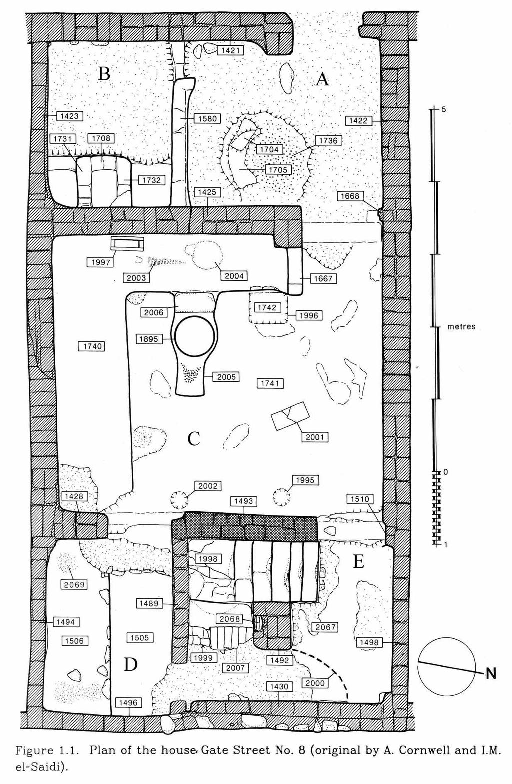
3 The Houses: The walled village contains several rows of neatly planned houses, all roughly the same size. Gate Street 8 is the most completely excavated house and has many features typical of the rest of the houses at the site. There is a plan of this house on page 5. The house is divided into three major areas, with the front and back areas further subdivided into two rooms each. A. Northern Front Room (c. 2.7 x 2.3 metres): This room opens onto the street. The walls of this room have been coated with plaster and whitewashed with a gypsum mixture. The front area of the house is the only part of it that is whitewashed in this fashion. The features on the floor (marked on the plan as 1704, 1706 and 1736) are modern disturbances to the surface of the floor, not part of the ancient building. B. Southern Front Room (c x 2.3 metres): The primary feature of the south room is a structure that has been built into the eastern wall (marked on the plan as 1708, 1731 and 1732). This box-shaped structure is about 40 centimetres tall. From similar structures at other sites and models in tombs, we know that these were used for setting large querns into for the milling of grain. C. Middle Room (c x metres): This is the largest room of the house. Along the west and south walls of this room runs a lowlying, L-shaped bench, 7 centimetres high off the floor. On the western part of this bench there is an upturned limestone table-top (1997), an area of wear in the plaster where a chair may have been (2004), and impressions in the plaster itself from a mat laid on the bench (2003). A second limestone table-top (2001) lies on the floor. On a projection from the bench is a large, broad, thick-walled, pottery bowl (1895) containing a small deposit of ash. Against the east wall are two shallow circular depressions in the floor where pottery vessels had stood (1995, 2002). D. Southern Rear Room (c x 1.75 metres): The only significant feature of this room is a low bench (1506). At either end of this bench patches of the plaster show traces of wear possibly as a consequence of a piece of furniture once laying there. E. Northern Rear Room: This room contains a well-preserved staircase leading upwards, with a small cupboard under the stairs. The angle of the staircase indicates that the ceilings were not inconveniently low one could stand fully upright in these rooms, though the staircase may have been awkward to navigate. The evidence suggests that the middle room and rear rooms were certainly roofed, though it is not clear whether the front rooms covered by a roof they may have been only partially enclosed. 3
4 Although it was originally suggested that the staircases in these houses only led to rooftop access, the amount of fill in the middle and rear rooms (and some of the items, such as wooden shutters, well-decorated plaster, and localized evidence of fire) suggests a collapsed upper storey. This upper storey may have contained a sleeping area and a kitchen, but it is impossible to say for certain. Although the structural features are well preserved, there is very little domestic debris left at the houses, suggesting that they were regularly cleaned and the refuse taken to rubbish dumps throughout the surrounding area. 4
5 5
6 Animal Pens and Garden Plots: There are several areas of the site (including the annexe to the chapel, see below) where clear garden beds had been laid out, with alluvial soil from the Nile floodplain deliberately brought to the site for the purpose. Preliminary analysis of botanical remains provides evidence for the presence of several species, including: barley, wheat, peas, lentils, cucumber, onion, garlic, a variety of herbs, flax, pomegranate, grape, watermelon, fig, olive, almond, and date. At least seven different sets of animal pens were present at the site (one of these, the one next to the main chapel, is shown in the plan on the following page). These pens consist of a courtyard with access to a series of smaller pens. The courtyards and some of the pens had limestone troughs. Although the pens themselves are relatively clean, analysis of animal bones from the rubbish pits helps to provide information on the animals kept in these pens. Only bones of oxen, goats and pigs are found at this site. Oxen are certainly too large to have been kept in these pens, and analysis of the coprolites found in the pens themselves points to pigs as the primary occupants. This is of note as pigs require a great deal of water and are not particularly easy animals to raise in a desert environment. 6
7 7
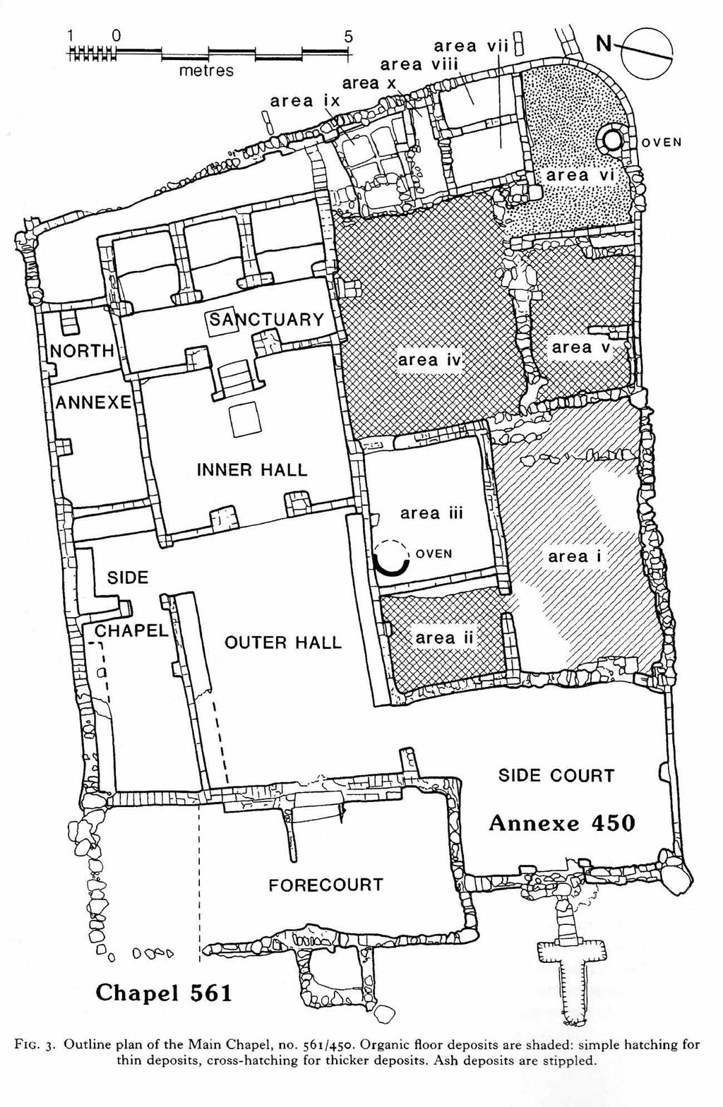
8 The Main Chapel: There are several chapels present at the site, all located outside the main city walls. The largest and best preserved of these was called the main chapel by the excavators. Half of the building is the chapel proper, the rest consists of an annexe that runs along the south side of the chapel (see plan on following page). The chapel itself follows a fairly standard design for this time period in Egypt: a sequence of two halls followed by a sanctuary with three shrines, the whole arranged symmetrically on a central axis. Low square offering tables of brick stand in the centre of the floors of the Inner Hall and Sanctuary; benches line the two principal walls of the Outer Hall. The walls which subdivide these rooms were screen walls, rising to a height of about 1.2 metres. All areas inside the chapel were roofed, including the Outer Hall. The inner surfaces of the chapel walls were entirely plastered and painted. The plaster is fragmentary, but it can be determined that the Sanctuary was painted with images of stylized vultures, as well as floral and geometric motifs. The Inner Hall has images of a male and female with incense cones on their heads, holding bouquets of flowers probably representing participants in religious ritual. What is most interesting about the paintings at the chapel is that they are not in the style of the Amarna ruling elite but share strong similarities with the older (and at this period not politically favored) art style. There is not enough evidence at the temple to suggest the worship of a particular deity, though the proximity of the chapels to cemetery areas and the presence of at least one burial beneath the chapel itself might suggest a funerary temple function. The annexe on the south side of the chapel possessed a very different atmosphere. Its walls were not plastered and on its floor lay a deposit of organic debris. Most of this area was also unroofed. The function of the annexe seems to have been the provision of food: animals were probably kept in areas i and ii, areas iii and vi contained ovens, area ix contains a podium supporting five square plots for the growing of flowers or vegetables. 8
9 9
10 Based on the data presented, your task in this assignment is to evaluate the quality of life for the individuals living in the workers village outside of the city of Amarna. Your report on the general lifestyle of the villagers should address the following questions: How big are the houses at the village? How many people likely lived in each building? Roughly how many people would have lived in the village? What sorts of activities were performed in the houses? What was peoples diet like? Do you think it was nutritionally adequate? What types of activities did people do outside their houses? Was there a sense of group community or identity? Does the evidence support the typical Hollywood portrayals of the lives of Egyptian workers? Note: You won't necessarily be able to sift through the data and find straightforward answers. This is a chance to use your skills in interpretation and inference. Make sure you indicate which evidence leads you to your conclusions. 10
The Pyramids of Ancient Egypt
 The Pyramids of Ancient Egypt By History.com, adapted by Newsela staff on 08.01.17 Word Count 901 Level 1060L The Great Pyramid of Giza, also called the Pyramid of Khufu or Cheops, is the oldest and largest
The Rosetta Stone. Writing in Ancient Egyptian
 Writing in Ancient Egyptian The Rosetta Stone The hieroglyphic writing system used more than 600 symbols, mostly pictures of objects. Each symbol represented one or more sounds in the Egyptian language.
Ancient and Egyptian Architecture
 Ancient and Egyptian Architecture Topics Egyptian Civilization Egyptian Architectural Characteristics Mastabas Saqqara Pyramid at Medum Khufu s Pyramid at Giza Additional Giza Structures Characteristics
The Rise of Civilization. Ancient Egypt
 The Rise of Civilization Ancient Egypt Geography The Egyptian civilization was located in Egypt in North Africa. The Egyptian empire was located on the lower deltas of the Nile River. The Egyptians lived
Egyptian Achievements
 N4 SECTION Egyptian Achievements What You Will Learn Main Ideas 1. The Egyptians developed a writing system using hieroglyphics. 2. The Egyptians created magnificent temples, tombs, and works of art. The
Excavations in a Medieval Market Town: Mountsorrel, Leicestershire,
 Excavations in a Medieval Market Town: Mountsorrel, Leicestershire, by John Lucas Mountsorrel is situated 12 kms north of Leicester and forms a linear settlement straddling the A6, Leicester to Derby road.
Antinoupolis. Ongoing Destruction. Pre-2006 crops. Modern cemetery covering. ancient cemetery. Antinoupolis, ancient city. North cemetery (ancient).
.") Antinoupolis Ongoing Destruction Ongoing Destruction North cemetery (ancient). Pre-2006 crops Modern cemetery covering ancient cemetery. Antinoupolis, ancient city. Modern village of el Sheikh Abada Nile
Antinoupolis Ongoing Destruction Ongoing Destruction North cemetery (ancient). Pre-2006 crops Modern cemetery covering ancient cemetery. Antinoupolis, ancient city. Modern village of el Sheikh Abada Nile
archeological site LOS MILLARES
 archeological site LOS MILLARES Aerial view of the plain of Los Millares between the Rambla de Huéchar and the River Andarax The archaeological site of Los Millares is located in the township of Santa
IAS Prelims Exam: Ancient History NCERT Questions: The Harappan Civilisation Set II
 IAS Prelims Exam: Ancient History NCERT Questions: The Harappan Civilisation Set II Questions asked from Ancient Indian History section in IAS Prelims Exam are quite easy but the candidates need to memorise
archaeological site GADES Columbaria Roman Theatre Salting Factory
 archaeological site GADES Columbaria Roman Theatre Salting Factory In the final days of the Roman Republic and the early years of Augustus rule, the city of Gades experienced a period of economic and political
Town Planning in Ancient Egypt
 Town Planning in Ancient Egypt Location The reasons for the foundation of a new settlement could be varied: security, often combined with economics, as in the case of the southern fortress towns (Buhen);
Life in Ancient Egypt
 Life in Ancient Egypt Text: http://www.ancientegypt.co.uk/ Photos: Google Images (public domain) The civilization of ancient Egypt lasted for over three thousand years. During this time there were many
CARN BAN LONG CAIRN HISTORIC ENVIRONMENT SCOTLAND STATEMENT OF SIGNIFICANCE. Property in Care (PIC) ID: PIC059 Designations:
 ID: PIC059 Designations:") Property in Care (PIC) ID: PIC059 Designations: Scheduled Monument (SM90051) Taken into State care: 1962 (Guardianship) Last reviewed: 2004 HISTORIC ENVIRONMENT SCOTLAND STATEMENT OF SIGNIFICANCE CARN
Property in Care (PIC) ID: PIC059 Designations: Scheduled Monument (SM90051) Taken into State care: 1962 (Guardianship) Last reviewed: 2004 HISTORIC ENVIRONMENT SCOTLAND STATEMENT OF SIGNIFICANCE CARN
Ancient River Valley Civilizations Egypt
 Ancient River Valley Civilizations Egypt Geography of Egypt The first civilization in Africa developed along the Nile River, in a place called Egypt. These humans were at first nomadic, also known as hunter-gatherers.
The Greek-Swedish-Danish Excavations at Kastelli, Khania 2010 a short report
 The Greek-Swedish-Danish Excavations at Kastelli, Khania 2010 a short report During six weeks from 19 July to 27 August the Greek-Swedish-Danish Excavations continued work in the Ag. Aikaterini Square
General Introduction to Ancient Egypt
 Name Date Period General Introduction to Ancient Egypt The Geography of the Nile The Nile flows north from East Africa to the Mediterranean Sea. Along the way there are rough, rocky areas called cataracts.
As both one of the few substantially preserved pharaonic Egyptian. expulsion, the site of Deir el-ballas is of great archaeological and historic
 The 2017 Season at Deir el-ballas Peter Lacovara As both one of the few substantially preserved pharaonic Egyptian settlements as well as the forward capital for the Theban kings during the Hyksos expulsion,
Following the initial soil strip archaeology is sprayed up prior to planning and excavation
 Barton Quarry & Archaeology Over the past half century quarries have been increasingly highlighted as important sources of information for geologists, palaeontologists and archaeologists, both through
In 2014 excavations at Gournia took place in the area of the palace, on the acropolis, and along the northern edge of the town (Fig. 1).
.") Gournia: 2014 Excavation In 2014 excavations at Gournia took place in the area of the palace, on the acropolis, and along the northern edge of the town (Fig. 1). In Room 18 of the palace, Room A, lined
Gournia: 2014 Excavation In 2014 excavations at Gournia took place in the area of the palace, on the acropolis, and along the northern edge of the town (Fig. 1). In Room 18 of the palace, Room A, lined
Villa San Michele Region: Puglia Sleeps: 8
 Villa San Michele Region: Puglia Sleeps: 8 Overview Immersed in the green of the countryside and within easy reach of stunning beaches, this beautiful historic masseria sleeping 8. It has a large swimming
Gorse Stacks, Bus Interchange Excavations Interim Note-01
 Gorse Stacks, Bus Interchange Excavations 2015 Prepared for: Cheshire West & Chester Council Interim Note-01 1 Introduction & Summary Background Since c. 2000 investigations associated with redevelopment
Villa San Michele Region: Puglia Sleeps: 8
 Villa San Michele Region: Puglia Sleeps: 8 Overview Set on five acres among olive and almond trees and brimming with history, this villa in Puglia was once a chapel and monastery dating back to the 1300s.
MarshallHigh School. Marshall High School
 Marshall High School MarshallHigh School Mr. Cline Mr. Cline Western Civilization I: Ancient Foundations Western Civilization I: Ancient Foundations Unit Two FC Unit Two FC Houses were usually made out
Lesson 1: The Lifeline of the Nile
 Lesson 1 Summary Lesson 1: The Lifeline of the Nile Use with pages 78 81. Vocabulary delta a triangular-shaped area of soil at the mouth of a river silt a mixture of soil and small rocks papyrus a plant
The early Ramesside occupants of tomb MIDAN.05
 The early Ramesside occupants of tomb MIDAN.05 Marilina Betrò and Gianluca Miniaci continue the exploration of tomb MIDAN.05 in the Theban Necropolis. Discovered in 2004 by the archaeological expedition
IKLAINA ARCHAEOLOGICAL PROJECT 2012 FIELD REPORT
 IKLAINA ARCHAEOLOGICAL PROJECT 2012 FIELD REPORT Michael B. Cosmopoulos The sixth season of the Iklaina Archaeological Project was conducted for six weeks in June and July 2012. Τhe project is conducted
Gebel Barkal (Sudan) No 1073
 No 1073") Gebel Barkal (Sudan) No 1073 1. BASIC DATA State Party : Republic of Sudan Name of property: Gebel Barkal and the Sites of the Napatan Region Location: Northern state, province of Meroe Date received:
Gebel Barkal (Sudan) No 1073 1. BASIC DATA State Party : Republic of Sudan Name of property: Gebel Barkal and the Sites of the Napatan Region Location: Northern state, province of Meroe Date received:
The Italian Archaeological Mission in Sudan Ca Foscari University of Venice
 The Italian Archaeological Mission in Sudan Ca Foscari University of Venice Karima (Sudan) November-December 2012 The 2012 season of the Italian Archaeological Mission at Jebel Barkal was carried out between
Ancient Egypt. Written by Rebecca Stark Educational Books n Bingo
 Ancient Egypt Create-A-Center Written by Rebecca Stark Educational Books n Bingo DIRECTIONS FOR CREATING A LEARNING CENTER MATERIALS: 4 pieces of oak tag or heavy poster board, 28 x 22 Scissors Plastic
IMTO Italian Mission to Oman University of Pisa 2011B PRELIMINARY REPORT (OCTOBER-DECEMBER 2011)
") IMTO Italian Mission to Oman University of Pisa 2011B PRELIMINARY REPORT (OCTOBER-DECEMBER 2011) The 2011B research campaign took place in the area around Salut from October, 19 th, to December, 16 th.
IMTO Italian Mission to Oman University of Pisa 2011B PRELIMINARY REPORT (OCTOBER-DECEMBER 2011) The 2011B research campaign took place in the area around Salut from October, 19 th, to December, 16 th.
Report on the excavations on the site Novopokrovskoe II in V. Kol'chenko, F. Rott
 Report on the excavations on the site Novopokrovskoe II in 2016 V. Kol'chenko, F. Rott In 2016 the Novopokrovskiy archeological group of the Institute of History and Heritage of the National Academy of
The Nile is the world s longest river. It is 4,160 miles long. It flows north and empties into the Mediterranean Sea
 The Nile is the world s longest river. It is 4,160 miles long It flows north and empties into the Mediterranean Sea Lower Egypt is at the Nile s mouth near the Mediterranean Sea. It is in Northern Egypt
218 R. S. BORAAS AND S. H. HORN
 were able to show a sequence of ceramic corpora much more fully representative than those available from the occupation surfaces and structures higher on the mound. This ceramic series obtained from D.
Trench 91 revealed that the cobbled court extends further to the north.
 Report on the 2013 Gournia Excavations The 2013 excavations at Gournia were conducted June 17 July 26 under the aegis of the American School of Classical Studies at Athens and the supervision of the KD
Welcome to Egypt! But before we talk about anything else, we have to talk about the most important thing in Egypt. (other than me) the Nile River.
 the Nile River.") Welcome to Egypt! Hi! My name is Sphinxy, your tour guide through the gift of the Nile. I ll show you all you need to know about the ancient kingdom of Egypt. (other than me) the Nile River. But before
Welcome to Egypt! Hi! My name is Sphinxy, your tour guide through the gift of the Nile. I ll show you all you need to know about the ancient kingdom of Egypt. (other than me) the Nile River. But before
Babylon. Ancient Cities by the River Lesson 5 page 1 of 6. Code of Hammurabi monument. E u p h. T i g r i s. r a t e s. Babylon, Mesopotamia
 Ancient Cities by the iver Lesson 5 page 1 of 6 1700s BCE, and established the importance of the city for the region He was responsible for a code of laws/decrees to reestablish justice in the land His
Egypt and the Nile River Valley System. SC Standards 6-1.3, 1.4, 1.5
 Egypt and the Nile River Valley System SC Standards 6-1.3, 1.4, 1.5 Where is Egypt? Egypt is on the continent of Africa. The River Nile runs through Egypt The capital of Egypt is Cairo Where is Egypt?
Egypt: IMPACT OF THE GEOGRAPHY
 Egypt: IMPACT OF THE GEOGRAPHY Characteristics of Egyptian Civilization: Advanced Cities Characteristics of Egyptian Civilization: Advanced Cities Egyptian cities developed along the Nile River which
1: The Nile River Valley
 1: The Nile River Valley In Nubia and Egypt, the Nile flows through the Sahara, a vast desert that stretches across most of northern Africa. Before reaching Egypt, the river in ancient times roared through
Dawood Public School Course Outline Social Studies Class III
 1 Dawood Public School Course Outline 2014-15 Social Studies Class III Books: Mackay, Frances: Moorcroft, Christine. (2013). World Watch 3 and Work Book; Social studies for Primary schools. Oxford University
Egyptian Civilization (3100 B.C-332 B.C.)
") Egyptian Civilization (3100 B.C-332 B.C.) Ancient Egypt -a land of mysteries. No other civilization has so captured the imagination of scholars and public in general. Mystery surrounds its origins, its
Egyptian Civilization (3100 B.C-332 B.C.) Ancient Egypt -a land of mysteries. No other civilization has so captured the imagination of scholars and public in general. Mystery surrounds its origins, its
We have compared the way a historian works to the way a detective
 2.8 Primary and Secondary Sources We have compared the way a historian works to the way a detective works. The main difference between detectives and historians is the evidence they work with. Detectives
Narmer, but no one knows for sure. would be known about the time period. archaeologists. people began to refer to their king as a pharaoh during
 Score Chapter 3: Ancient Egypt and Nubia Lesson 2: Life in Egypt Textbook pages 84 to 90 Name: Ms. Samuels - answers Class/Period: Date: Essential Questions Why do you think the two kingdoms may have united?
Friends Meeting House, Hitchin. 1 Paynes Park, Hitchin, Hertfordshire, SG5 1EH. National Grid Reference: TL Statement of Significance
 Friends Meeting House, Hitchin 1 Paynes Park, Hitchin, Hertfordshire, SG5 1EH National Grid Reference: TL 18282 29279 Statement of Significance A meeting house of 1957 designed by Paul V. Mauger and erected
4. Bronze Age Ballybrowney, County Cork Eamonn Cotter
 4. Bronze Age Ballybrowney, County Cork Eamonn Cotter Illus. 1 Location map of the excavated features at Ballybrowney Lower (Archaeological Consultancy Services Ltd, based on the Ordnance Survey Ireland
Life in Ancient Egypt
 Life in Ancient Egypt Rapid Fire- SGA Instructions! Groups will have 5 min to create a rapid fire SGA.! Using the information provided, you must say the highlighted words on your resource sheets! You must
Name. Famous Pyramids. by Cindy Grigg
 Name Famous Pyramids by Cindy Grigg Answer the following questions BEFORE you read this book. It is okay if you do not know as much as you thought. Do the best you can! 1.Who built the pyramids? Is Egypt
Portway Farm, Twyford
 Portway Farm, Twyford Buckinghamshire Archaeological Society HISTORIC BUILDING REPORT / April 2011 Including HS2 high-speed rail line Impact Assessment SURVEY AND REPORT: Sue Fox and John Brushe Report
Life in Roman Britain
 Roman 4: Roman Home Life in Roman Britain The Romans set up administra ve centres to run the province and involved the local tribal elite in the decision process. They encouraged them to build dwellings
SEVEN LAYER MONUMENTS OF THE EARLY OLD KINGDOM FORTHCOMMING
 SEVEN LAYER MONUMENTS OF THE EARLY OLD KINGDOM FORTHCOMMING إن شاء هللا FUNERARY PYRAMIDS Are: Stepped, Bent, Benben, or of True forms with some PROPERTIES namely: 1 - Correctness of SHAPE, 2 - STABILITY
The DIG Visual Story. What you might see
 The DIG Visual Story What you might see When you arrive at DIG you should see one of our helpful staff at the admissions desk. They may look like the one in the photo below dressed in their uniform. They
LECTURE: EGYPT THE GIFT OF THE NILE
 THE GIFT OF THE NILE I) The Nile River a. I know the Nile. When he is introduced in the fields, his introduction gives life to every nostril. Temple inscription b. Longest river in the world c. Runs south
Month Contents Page #
 1 Dawood Public School Course Outline 2017-2018 Social Studies Class III Books: Mackay, Frances: Moorcroft, Christine. (2013). World Watch 3 and work book; Social studies for Primary schools. Oxford University
: southern pilaster of the entrance. The tomb owner, Redi, is depicted in painted raised relief ( a 8014) Plate 15
 Plate 15") 15. 2086: southern pilaster of the entrance. The tomb owner, Redi, is depicted in painted raised relief ( a 8014) Plate 15 16. 2086: south wall. Redi is seated with a woman, receiving a lotus, and entertained
15. 2086: southern pilaster of the entrance. The tomb owner, Redi, is depicted in painted raised relief ( a 8014) Plate 15 16. 2086: south wall. Redi is seated with a woman, receiving a lotus, and entertained
aiton.new 1/4/04 3:48 AM Page 2
 aiton.new 1/4/04 3:48 AM Page 2 Below: An aerial view of area A of the excavations. A massive square building that appears to be a fortress was discovered in this area at the top of the tell. aiton.new
Chapter 2. Daily Focus Skills Transparency 2 2
 Chapter 2 Daily Focus Skills Transparency 2 2 Recognize the role of major religion Explain the development of a people's need to belong and organize into a system of governance Describe the purposes and
AFRICAN CIVILIZATION. The Kushite Kingdom in Upper Egypt and the Sudan
 AFRICAN CIVILIZATION The Kushite Kingdom in Upper Egypt and the Sudan The Kingdom of Kush The civilization of Kush thrived from about 2000 B.C.E. to 350 C.E. Kush and Egypt had a close relationship throughout
Plates. Kom Firin I 193. Plate 96 View of the southwestern part of Kom Firin, looking west-southwest.
 Plates Plate 96 View of the southwestern part of Kom Firin, looking west-southwest. Plate 97 Ramesside temple: wall 0157 and clean sand 0189 (TG), view to north. Plate 98 Ramesside temple: wall 0135 (TD),
TH E FIRST SEASON of investigations at the
 QUSEIR AL-QADIM Janet H. Johnson & Donald Whitcomb TH E FIRST SEASON of investigations at the ancient port of Quseir al-qadim on the Red Sea in Egypt took place in winter, 1978; the investigations were
Development of African Agriculture
 Development of African Agriculture Sahara desert originally highly fertile region Western Sudan region nomadic herders, c. 9000 BCE Domestication of cattle c. 7500 BCE Later, cultivation of sorghum, yams,
Jneneh in the Upper Wadi az-zarqa, in North Central Jordan, First Season 2011.
 Jneneh in the Upper Wadi az-zarqa, in North Central Jordan, First Season 2011. Khaled Douglas Jneneh is located in the north-western periphery of the city of Zarqa (grid ref. 250.88E 165.25N), in North
How Long Did It Take Pharaoh Khufu To Build His Pyramid
 How Long Did It Take Pharaoh Khufu To Build His Pyramid The Great Pyramid was built as a tomb for the pharaoh Khufu. At its base, each side is approximately 755 feet long. How long did it take to build
archaeological site MUNIGUA
 archaeological site MUNIGUA General view of the Sanctuary of Terraces from the access road HISTORY At Munigua, evidence of human occupation extends from the mid-4th century BCE to the 8th century CE. A
Historical value The building was erected on a new site to serve a new meeting and in itself is of low historical value.
 Quaker Meeting House, Welwyn Garden City 109 Handside Lane, Welwyn Garden City, Hertfordshire, AL8 6SP National Grid Reference: TL 23149 12617 Statement of Significance As first built in 1926 to the designs
Archaeological Investigations Project South East Region SOUTHAMPTON 2/842 (C.80.C004) SU
 SU") SOUTHAMPTON City of Southampton 2/842 (C.80.C004) SU 4382 1336 125 BITTERNE ROAD WEST, SOUTHAMPTON Report on the Archaeological Evaluation Excavation at 125 Bitterne Road West, Southampton Russel, A. D
SOUTHAMPTON City of Southampton 2/842 (C.80.C004) SU 4382 1336 125 BITTERNE ROAD WEST, SOUTHAMPTON Report on the Archaeological Evaluation Excavation at 125 Bitterne Road West, Southampton Russel, A. D
Defining Civilization - McAdams
 Defining Civilization - McAdams Class stratification Ownership and control of production Political and religious hierarchies Central administration Division of labor Skilled workers Officials Peasants
CARLUNGIE EARTH HOUSE
 Property in Care (PIC) ID: PIC015 Designations: Scheduled Monument (SM90059) Taken into State care: 1953 (Guardianship) Last reviewed: 2004 HISTORIC ENVIRONMENT SCOTLAND STATEMENT OF SIGNIFICANCE CARLUNGIE
Tomb raiders: Eight ancient mummies found near Luxor, Egypt
 Tomb raiders: Eight ancient mummies found near Luxor, Egypt By Agence France-Presse, adapted by Newsela staff on 04.24.17 Word Count 646 Level 1180L An expert inspects a sarcophagus found with mummies
The City-Wall of Nineveh
 The City of Nineveh Nineveh has a very long history, with finds dating already back at fifth millennium. As part of the Assyrian empire, the city served as a regional center during the Middle and Early
The Nile Valley For use with pages 38 46
 READING ESSENTIALS AND STUDY GUIDE 2-1 The Nile Valley For use with pages 38 46 Key Terms cataract: spot of rapid waters in a river (page 39) delta: area of fertile soil at a river s end (page 39) papyrus:
Friends Meeting House, Leek. Overton Bank, Leek, ST13 5ES. National Grid Reference: SJ Statement of Significance
 Friends Meeting House, Leek Overton Bank, Leek, ST13 5ES National Grid Reference: SJ 98200 56563 Statement of Significance The meeting house was purpose-built in 1697 and has high heritage value, as an
Egyptian Pyramids. Ancient Egyptian Art: Day 2
 Egyptian Pyramids Ancient Egyptian Art: Day 2 The Old Kingdom: Most people associate pyramids with the great Old Kingdom pyramids at Giza. The gigantic stone pyramids were actually built over the course
Ancient Egyptian Pharaohs Lesson 1
 Ancient Egyptian Pharaohs Lesson 1 L.O. To understand the importance of Pharaohs and Dynasties in Ancient Success Criteria ***I can explain why a Pharaoh was the ruler. **I can define what a dynasty is.
 Unifying Egypt (p. 85) Ancient Egypt was divided into two parts Upper Egypt and Lower Egypt. One famous legend tells of the king of Upper Egypt, whose name was Menes. He defeated the king of Lower Egypt
Chapter 25 Geography and the Settlement of Greece. How did geography influence settlement and way of life in ancient Greece?
 Chapter 25 Geography and the Settlement of Greece 25.1 Introduction How did geography influence settlement and way of life in ancient Greece? Tal Naveh/Shutterstock The ancient Greeks learned to use the
GOLDEN AGE A new dynasty of pharaohs came to power Moved the capital to Thebes Started a period of peace and order called The Middle Kingdom Lasted
 5.3 GOLDEN AGE A new dynasty of pharaohs came to power Moved the capital to Thebes Started a period of peace and order called The Middle Kingdom Lasted from 2055 BCE to 1650 BCE CONQUESTS Controlled
Egypt (The Nile River Valley)
") 2 nd Quarter Civilizations Mesopotamia (The Tigris & Euphrates) Egypt (The Nile River Valley) India (The Indus River) China (The Yellow River) 1 River Valley Civilizations 2 3 2 nd Quarter 2017 ISN Table
2 nd Quarter Civilizations Mesopotamia (The Tigris & Euphrates) Egypt (The Nile River Valley) India (The Indus River) China (The Yellow River) 1 River Valley Civilizations 2 3 2 nd Quarter 2017 ISN Table
EXCAVATIONS AT AIXONIDAI HALAI VOULA FIELD SCHOOL
 EXCAVIONS HALAI J A N U A R Y 8-2 7, 2 0 1 8 I N S T R U C T O R : D R. J O H N K A R A V A S VOULA FIELD SCHOOL EXCAVIONS HALAI COURSE DETAILS Dates : January Students who have a serious interest in archaeology
"To speak the name of the dead is to make him live again"
 "To speak the name of the dead is to make him live again" Ancient Egypt civilization lasted over 3000 years. Egyptian monuments have been around so long that their monuments were ancient even in Greek
Ancient Egypt OBJECTIVE: TO UNDERSTAND THE IMPORTANCE OF THE NILE RIVER TO THE ANCIENT EGYPTIANS.
 Ancient Egypt OBJECTIVE: TO UNDERSTAND THE IMPORTANCE OF THE NILE RIVER TO THE ANCIENT EGYPTIANS. Early Kingdom Around 3100 BC, King Menes, the ruler of Upper Egypt, conquered the Nile Delta and Lower
Cairo Pyramids Hotel MS Royal Princess
 HELLO, I m here in duty for Mr. NOUR / Mr. SALAH General Manager Budget Oasis Pyramids Hotel Superior MS Princess Sara Cairo Pyramids Hotel MS Royal Princess Superior Le Passage Heliopolis MS Semeramis
5. What do you notice about population distribution and settlement location in Ancient Egypt? List three or four reasons for this.
 Document A Source: Map created from various sources. Egypt circa 1500 BCE Mediterranean Sea 1. The Nile is the world's longest river, 4,160 miles. Consider the southern boundary of Ancient Egypt to be
How the Nile River Led to Civilization in Ancient Egypt
 How the Nile River Led to Civilization in Ancient Egypt By USHistory.org, adapted by Newsela staff on 03.07.17 Word Count 786 Level 950L TOP: This photo, taken around 1915, shows the flooding of the Nile
12/2/11$ Egypt. Lower Egypt SUMER. Upper Egypt
 Egypt Lower Egypt SUMER Upper Egypt 1$ ! Giza/ Saqqara! Memphis! Valley of Kings Timeline Ancient Egypt Predynastic SUMER (up to Early Dynastic) Middle Kingdom Archaic / Old Kingdom New Kingdom / Ptolemy
Ancient Egypt - Hatshepsut
 Name Date Class Ancient Egypt - Hatshepsut The Queen Who Was King Social Studies 8B A PROPOSAL TO: Mr. K. Burgess Group: March 13/20, 2012 In the midst of the past, one of the most technological and advanced
REPORT NUMBER 001 ARCHAEOLOGICAL DOWSING SURVEY BISHOPS SUTTON NEAR ALRESFORD HAMPSHIRE. D P BRYAN BA (Hons) MARCH 2012
 MARCH 2012") REPORT NUMBER 001 ARCHAEOLOGICAL DOWSING SURVEY AT BISHOPS SUTTON NEAR ALRESFORD HAMPSHIRE D P BRYAN BA (Hons) MARCH 2012 1 Table of Contents 1. Introduction 1.1 Project Background Page 2 1.2 Site Location
REPORT NUMBER 001 ARCHAEOLOGICAL DOWSING SURVEY AT BISHOPS SUTTON NEAR ALRESFORD HAMPSHIRE D P BRYAN BA (Hons) MARCH 2012 1 Table of Contents 1. Introduction 1.1 Project Background Page 2 1.2 Site Location
Chapter 5 Lesson 1 Notes: The Gift of the Nile
 Chapter 5 Lesson 1 Notes: The Gift of the Nile Geography of Ancient Egypt The Longest River The River is 4,160 miles long - is the world s longest river - begins near equator in Africa - flows north to
Cairo Pyramids Hotel MS Royal Princess
 HELLO, I m here in duty for Mr. NOUR / Mr. SALAH General Manager Budget Oasis Pyramids Hotel Superior MS Princess Sara Cairo Pyramids Hotel MS Royal Princess Superior Le Passage Heliopolis MS Semeramis
NEW TOMBS WITH EARLY CHRISTIAN MURALS FROM THE NECROPOLIS OF TAURIC CHERSONESUS (PRELIMINARY NOTE) V.M. Zubar and R. Pillinger
 V.M. Zubar and R. Pillinger") TALANTA XXXII-XXXIII (2000-2001) NEW TOMBS WITH EARLY CHRISTIAN MURALS FROM THE NECROPOLIS OF TAURIC CHERSONESUS (PRELIMINARY NOTE) V.M. Zubar and R. Pillinger In May 1998 a joint team of the Institute
TALANTA XXXII-XXXIII (2000-2001) NEW TOMBS WITH EARLY CHRISTIAN MURALS FROM THE NECROPOLIS OF TAURIC CHERSONESUS (PRELIMINARY NOTE) V.M. Zubar and R. Pillinger In May 1998 a joint team of the Institute
Chan Chan archaeological site (Chimu Empire), Trujillo
, Trujillo") Chan Chan archaeological site (Chimu Empire), Trujillo Book: "Trujillo, A Treasure in Mud and Color" by Alfredo Rios Mercedes Chart of Chan Chan. The separate cities today have been given the names of
Chan Chan archaeological site (Chimu Empire), Trujillo Book: "Trujillo, A Treasure in Mud and Color" by Alfredo Rios Mercedes Chart of Chan Chan. The separate cities today have been given the names of
Reading Comprehension-Ancient E
 Reading Comprehension-Ancient E NtryL`.--- #n6 I_nstructtons= Read the story below. Then, answer the questions and complete each activity` Be sure to highiighi or underline where you f iund each answer.
THE HEUGH LINDISFARNE
 LINDISFARNE COMMUNITY ARCHAEOLOGY THE HEUGH LINDISFARNE Archaeological excavations in June 2017 Invitation to volunteers THE HEUGH, LINDISFARNE, NORTHUMBERLAND: ARCHAEOLOGICAL EXCAVATIONS 2017 INTRODUCTION
Lancaster Castle THE CASTLE STUDIES GROUP JOURNAL NO 26:
 Lancaster Castle. The Henry IV gatehouse from the south-east. The C15 gatehouse subsumes a C12/13 stone gateway, observable inside the gate passage beyond the portcullis. The lower level loops originally
Egyptian archaeologists discover a 3,500-year-old tomb and mummies
 Egyptian archaeologists discover a 3,500-year-old tomb and mummies By Agence France-Presse, adapted by Newsela staff on 04.24.17 Word Count 717 Level 940L An expert inspects a sarcophagus found with mummies
The Holy Monastery of Kaisariani
 Ismene Kafantari, Anavryta Lyceum Instructor: Dr. Nicolaos A. E. Kalospiros Marousi, September 2016 The Holy Monastery of Kaisariani Location: Architectural type: Date: Mount Hymettus Cross-in-square Second
Friends Meeting House, Leicester. 16 Queens Road, Leicester, LE2 1WP. National Grid Reference: SK Statement of Significance
 Friends Meeting House, Leicester 16 Queens Road, Leicester, LE2 1WP National Grid Reference: SK 59852 02815 Statement of Significance A meeting house purpose-built on a new site in 1955 and slightly enlarged
Revisit Roman Arbeia Fort site information: teacher s notes
 Revisit Roman Arbeia Fort site information: teacher s notes Revisit Roman Arbeia is split into four parts, all of which can be downloaded from Tyne & Wear Archives & Museums website: Gallery Search Tick:
Shaded relief map of Egypt
 PHYSICAL LANDSCAPES OF ANCIENT EGYPT EGYPT: GIFT OF THE NILE - HERODOTUS MODIS (Moderate Resolution Imaging Spectroradiometer) image of the Nile River Valley, from NASA. Dr. John Paul Stimac Honors College
B 1200: The Napatan palace and the Aspelta throne room.
 B 1200: The Napatan palace and the Aspelta throne room. The labyrinthine mud brick walls southwest of B 800 are the remains of the Napatan palace, designated "B 1200," at Jebel Barkal (fig. 1). Until now
How old are the pyramids? where? What? How long? How were they built? There is the Pyramid because it s the biggest.
 WHO built the (info gap in pairs: listen to your friend and write the missinng information) (Pair A/B and A1/B1) A) *** Tens of thousands of ordinary Egyptian men, led by, engineers and other experts.