Archaeological Observation at The Bishop s Palace, Alvechurch, Worcestershire
|
|
|
- Scott Blake
- 5 years ago
- Views:
Transcription

1 Warwickshire County Council THE MOAT HOUSE Archaeological Observation at The Bishop s Palace, Alvechurch, Worcestershire Chris Jones and Bryn Gethin Report 1059 December 2010
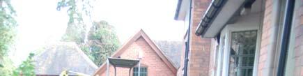
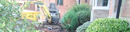
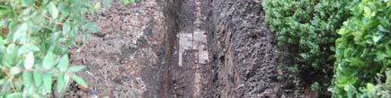
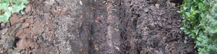
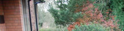
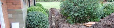
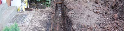
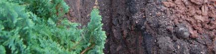
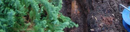
2 The Moat House: Archaeological Observation at the Bishop s Palace, Alvechurch, Worcestershire Chris Jones and Bryn Gethin Contents Summary 1 Introduction 2 Location 3 Archaeological and Historical Background 4 Observation of Groundworks 5 Conclusions Acknowledgements Bibliography Appendix A List of Finds Appendix B List of Contexts List of Figures Cover Moat and moat platform looking north-west Fig 1 Fig 2 Fig 3 Fig 4 Site Location Trench observed Trench looking north-east Trench looking north-east, detail Fig 5 New manhole area looking north-east, layers 1-4 Fig 6 Fig 7 Dog-leg trench looking north-east Trench looking south-west Report 1059 December 2010 Archaeology Warwickshire Warwickshire Historic and Natural Environment The Butts Warwick CV34 4SS
3 Summary Archaeological observations made during the replacement of a sewer at The Moat House, Alvechurch, Worcestershire, revealed no significant archaeological finds or deposits. The trench was cut mostly within an earlier sewer pipe trench, resulting therefore, in minimal damage to any potential archaeological remains. Fragments of ceramic tiles and mortar found in a garden soil layer probably derived from the demolition of the bishop s palace in the late 18th century. 1 Introduction 1.1 A new manhole and foul water sewer were required at The Moat House, Alvechurch, Worcestershire. The site lies in an area once occupied by the medieval bishop s palace of Alvechurch, and is Scheduled as an Ancient Monument (No 30009). A condition of the Scheduled Monument Consent required the applicant to secure the implementation of a programme of archaeological work to be carried out in conjunction with the groundworks. 1.2 A programme of fieldwork, comprising the archaeological observation of the excavation of the drain trench, was commissioned from the Warwickshire Museum Archaeology Projects Group and carried out in November This report presents the results of that work. The project is archived under the site code BP10. 2 Location 2.1 The Moat House is located on the south-east side of Radford Road on the eastern side of Alvechurch and centred on national grid reference SP (Fig 1). The groundworks were confined to the private garden. 2.2 The underlying geology of the area is Red Brown Mudstone of the Mercia Mudstone Group (British Geological Survey 1989). 3 Archaeological and Historical Background 3.1 Alvechurch was probably part of the 20 hides at Westhill, Coston Hackett and Rednall granted to the abbey of Bredon by king Offa of Mercia in 780. It passed subsequently to the See of Worcester, along with the rest of the abbey s possessions. The manor was given to the crown in 849 in return for royal protection but was returned to the See of Worcester by king Athelstan in 930 (VCH 1913, 252). The manor is mentioned in Domesday Book (1086) when it had a priest and it is possible that the bishops of Worcester had a residence there by this date (Dalwood et al 1995, 2). 3.2 The moated bishop s palace (Worcestershire Historic Environment Record No WSM 17709) probably originated at the same time as the deer park which is first mentioned in the late 12th century, though the palace itself is not recorded until 1236 (WSM 01232). By the 16th century it was in a poor state, though bishop Latimer subsequently repaired it (Dalwood et al 1995, 2). Alvechurch was retained by the See until 1648 when it was sold by the parliamentary trustees following the civil war. It was returned to the See of Worcester after the restoration (VCH 1913, 252), but by 1701 the moated site was occupied by orchards, which survived until at least 1927 (Ordnance Survey 1884, 1904, 1927, 1938), while the deer park had been divided up into farms (Dalwood et al 1995, 2). The palace itself was finally demolished in 1780
4 (Oswald 1954, 6), but the manor of Alvechurch remained in the ownership of the See of Worcester until 1860 when it was taken over by the ecclesiastical commissioners (VCH 1913, 252). 3.3 The earliest recorded form of the place name Alvechurch is Aelfithe cyrce (Mawer and Stenton 1927, 332-3), meaning "Aelfgyth's church" and may indicate that the church was founded before the 11th century (Dalwood et al 1995, 2). The church of St Lawrence (WSM 01830) stands on higher ground to the west of the existing town, and was probably the focus of settlement at Alvechurch in the late Anglo-Saxon period and in the 11th to 12th century (WSM 17221). The existing structure is largely 19th century; though with elements surviving from the 14th century (VCH 1913, 255). The early settlement would have been abandoned when the new town (WSM 29061) was laid out to the east in the 13th century (Dalwood et al 1995, 3). 3.4 The mesne borough of Alvechurch was probably formed by the Bishop Walter of Worcester and was laid out at the gate of the palace in c 1239 when he was granted a weekly market and annual fair (Dalwood et al 1995, 2). The borough is recognised in bishop Gifford s register ( ) and by the 1290s the number of burgage tenements have been estimated at between 74 (VCH 1913, 252) and 76½ (Dalwood et al 1995, 2). The borough was never as successful as its neighbour Stratford-upon- Avon, founded by the bishops of Worcester in 1196 and its burgesses do not appear to have acquired any real independence (VCH 1913, 252). 3.5 Although further post-medieval tenement plots have been identified, documentary evidence suggests that there was a period of economic decline in the 17th century, after which the settlement was demoted to village status (Dalwood et al 1995, 9). The borough was in further decline by the end of the 18th century (Dalwood et al 1995, 9) by which time its market had ceased to function (VCH 1913, 253). 3.6 The bishop's palace (WSM 17709) today consists of the rectangular moated site, surrounding two platforms/islands, which housed the main palace buildings (WSM 01829). The Moat House now stands on the northern platform (Fig 1). This is recorded as having origins in the late 18th century (English Heritage 1998; Appendix C) but the existing structure dates largely from the late 19th century (Ordnance Survey 1884). Adjacent to the moated site were enclosures and agricultural buildings (WSM 01932, WSM 01933; see below, 3.7) and a dovecot (WSM 03303). To the north, east and south are the remains of a series of fishponds and islands (WSM 01831), a pond dam (WSM 01832), probable mill site (WSM 02071) together with leats (WSM 17190, WSM 17191) and an overflow channel (WSM 31962) related to the waterworks. A holloway (WSM 16713) runs to the east of the main fishponds. The bishop's deer park (WSM 01232) was adjacent to the palace (Dalwood et al 1995, 4). A full description is available in the Ancient Monument Schedule (see Appendix C). 3.7 Archaeological excavations carried out in to the north-east of the moated platforms recorded a large building, with stone foundations and cobbled floors, of probable 13th century origin that was rebuilt in the early 16th century (Oswald 1954, 6, 8; WSM 01932, WSM 34875). This was interpreted as a probable barn or other agricultural structure. Earthworks in the area were dated to the late 17th century, while a section through part of the moat indicated that it had been cleaned out in the 17th century and lined with clay in the 19th century (Oswald 1954, 6). 3.8 The site of the medieval bishop s palace of Alvechurch is Scheduled as an Ancient Monument (No 30009).
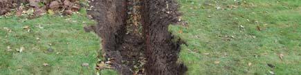
5 4 Observation of Groundworks 4.1 The groundworks consisted of the excavation of a manhole and trench for the replacement drain using a tracked mini-excavator with a toothless bucket (Figs 2-7). The trench measured 0.50m wide by 1.10m-1.25m deep, being deepest in the area of the new manhole (Fig 5) where it also widened out to c0.85m for a c2.5m stretch. The majority of the trench was cut entirely within the fill of a pre-existing pipe trench and thus did not expose any earlier deposits. This was apart from a widened area for the new manhole at the south-west end of the trench (Fig 5), and the dog-leg stretch running west from the north-east end of the pre-existing pipe towards the house (Figs 6 & 7). 4.2 In the area of the manhole (Fig 5) the geological natural strong brown clay (4) was recorded at c0.54m below the existing ground surface. This was overlain by a c0.10m thick layer of greenish grey sandy clay (3) that may itself have been a variation of the geological natural. Layer 3 was overlain by a c0.14m thick layer of greyish brown clay loam (2) that contained frequent small fragments of ceramic roof tile (not retained) and mortar flecks. This probably represents demolition material derived from a former building within the contemporary garden soil. Layer 2 was cut by the pre-existing sewer pipe trench, aligned roughly south-west to north-east. It was backfilled with a ceramic pipe (7) that lay at c1m below the existing ground surface. The pipe was overlain by a mixed deposit of greyish brown clay loam, strong brown clay and ash (6) from which a single sherd of 19th century willow pattern pottery and an iron object were noted. Pipe trench fill 6 was overlain by the c0.30m thick layer of dark greyish brown clay loam of the existing garden soil (1). 4.3 In the dog-leg trench (Figs 6 & 7) geological natural strong brown clay (4) was recorded at c1m below the existing ground surface. A further pipe trench (8) ran aligned roughly south-west to north-east, parallel to pipe 7 and slightly north-west of it. Pipe trench 8 had a ceramic pipe (10) in its base overlain by a backfill (9) identical to trench fill 6. Pipe trenches 5 and 8 were thus probably contemporary. Trench fill 9 was overlain by the c.0.24m thick dark greyish brown clay loam (11) of the existing flower bed. 5 Conclusions 5.1 No medieval deposits were disturbed by the groundworks. A large number of small fragments of ceramic roof tile were recorded that may have been of medieval date and possibly derived from the demolition of the bishop s palace, but these were too small to be diagnostic. 5.2 The new pipe trench was cut largely through the backfill of an earlier sewer pipe trench and thus sheds no light on the survival, or not, of any significant archaeological remains in the area. Acknowledgements The Warwickshire Museum would like to thank Tracy and Michael Fallon of The Moat House for commissioning the work. The project was managed by Stuart Palmer and work on site was carried out by Bryn Gethin. This report was written by Chris Jones with illustrations by Andy Isham. It was checked by Pete Thompson.
6 Bibliography British Geological Survey :50000 Series Solid and Drift Geology Sheet 183, Redditch Dalwood, H, Hurst, D, Morriss, R, Pearson E, and Stamper P, 1995 Archaeological assessment of Alvechurch, Hereford and Worcester, Central Marches Historic Towns Survey English Heritage 1998 Record of Scheduled Monuments, National Monument No Mawer, A, Stenton, F, 1927 Name Society, 4 eds The place-names of Worcestershire, English Place- Ordnance Survey st edition 1:2500 map of Worcestershire Ordnance Survey nd edition 1:2500 map of Worcestershire Ordnance Survey :2500 map of Worcestershire Ordnance Survey :2500 map of Worcestershire Oswald, A, 1954 Excavation at Alvechurch, Worcestershire, , Transactions of the Birmingham and Warwickshire Archaeological Society 72, 1954 VCH 1913 A History of the County of Worcester Vol. 3
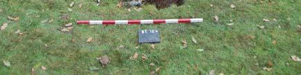
7 Appendix A List of Finds Context Material Quantity Date/Comments 6 pottery 1 19th century willow pattern (not retained) 6 iron 1 19th century plate with bolt attachment (not retained) Appendix B List of Contexts Context No. Description 1 topsoil 2 greyish brown clay loam layer 3 greenish grey clay, possible geological natural 4 strong brown clay, geological natural 5 sewer pipe trench 6 fill of trench 5 7 ceramic pipe in trench 5 8 sewer pipe trench 9 fill of trench 8 10 ceramic pipe in trench 8 11 dark greyish brown clay loam garden soil Appendix C Extract from the Record of Scheduled Monuments MONUMENT: Moated site and fishponds at the Bishop's Palace PARISH: ALVECHURCH DISTRICT: BROMSGROVE COUNTY: WORCESTERSHIRE NATIONAL MONUMENT NO: NATIONAL GRID REFERENCE(S): SP DESCRIPTION OF THE MONUMENT The monument includes the buried and earthwork remains of the palace of the bishops of Worcester and the moat, fishponds and mill sites associated with it. The double-island moated site of the palace lies in the north western part of the monument and is rectangular in shape. To the south east of the palace lies a second, single-island, sub-rectangular moat. To the north, east and south of this moated site is a large area of fishponds and other water management features bounded on the west and south by the River Arrow. The palace is documented from around AD
8 1230, although the park is recorded from about AD 1160 and manorial records survive from the time of King Offa. In the 16th century Leyland recorded that the decayed timber palace had been recently restored by Bishop Latimer. An estate map of 1701 recorded both parts of the moat as orchards and the buildings had certainly been demolished by around A late 18th century house now stands on the site. The park had been divided into several farms by the mid-19th century. The palace site, now known as The Moat House, measures 190m by 80m and is orientated north west-south east. The northern island is the larger, measuring approximately 80m by 60m. The main domestic building was sited on this island in the vicinity of the modern house, and some traces of earlier structures have been recorded in the gardens. Part excavation on the moat island has confirmed that domestic remains survive on the platforms. The island to the south east has an uneven surface with large depressions indicating the survival of either building or garden remains. It measures approximately 60m square. The surface of both islands is lower than that of the surrounding land. The circuit of the moat is complete except along the north western arm, parallel with the road, where it has been partly infilled to provide access. The moat is waterlogged and is 5m to 10m wide across the top and 1m to 2m deep. There are traces of an external bank on the eastern and southern sides. To the south east of the palace, across a tributary of the River Arrow, lies a second sub-rectangular moated site, known as the `Bishops Garden'. This moated site is built into steeply rising ground and forms a terraced area adjacent to the gorge of the stream. The moat has substantial external banks and is steep-sided and waterlogged. The island measures approximately 15m by 10m and its surface is uneven. The moat was supplied by a substantial leat, terraced into the slope and leading off the stream to the east and running parallel to it. An outlet lies in the north western angle of the moat. A substantial earthen bank or dam measuring 4m to 6m high and 4m wide across the top, runs across the floor of the valley from the gorge of the stream on the north west towards the rising land opposite, curving to run parallel to the valley sides on the south east. This acted as a causeway across the fishponds and also retained the water of the fishpond system. A leat was formed between the valley sides to the south east and the earthen dam. Several sluices were cut through the earthen dam which widens to form building platforms adjacent to the sluices. The sluices served to feed the fishponds and may also have been used to power water mills. The platforms are believed to preserve building remains associated with the functions of the fisheries and mills. The floor of the valley formed the site of a series of three fishponds which survive as waterlogged hollows lying along the course of a second stream or leat which entered the site in the north eastern corner near the earthen dam and which may have also been fed from the sluices. The valley widens to the south providing a large area of low-lying waterlogged ground which could be flooded by sluices in order to create further fishponds and water meadows. On the rising ground to the south east are medieval ridge and furrow cultivation remains with hollow ways providing routes between the fields and the fishpond sites. This area is important for understanding the economy of the community and is therefore included in the scheduling. The rising ground to the south west is bounded by the River Arrow and its tributary on the south and west, forming a broad, gently rising terraced platform above the flood plain, the surface of which has low level earthworks thought to represent the remains of building platforms. The 18th century house, associated structures and modern surfaces, the wooden footbridges and all modern fencing are excluded from the scheduling although the ground beneath all these features is included.
9 ASSESSMENT OF IMPORTANCE Bishops' palaces were high status domestic residences providing luxury accommodation for the bishops and lodgings for their large retinues; although some were little more than country houses, others were the setting for great works of architecture and displays of decoration. Bishops' palaces were usually set within an enclosure, sometimes moated, containing a range of buildings, often of stone, including a hall or halls, chapels, lodgings and a gatehouse, often arranged around a courtyard or courtyards. The earliest recorded examples date to the seventh century. Many were occupied throughout the medieval period and some continued in use into the post medieval period; a few remain occupied today. Only some 150 bishops' palaces have been identified and documentary sources confirm that they were widely dispersed throughout England. All positively identified examples are considered to be nationally important. The moated site of the Bishop's Palace is associated with a complex of fishponds, a moat system and mill sites. Fishponds are artificially created pools of slow moving fresh water constructed for the purpose of cultivating, breeding and storing fish to provide a constant and sustainable supply of food. They were created by damming narrow valleys, embanked above ground or dug into ground level, and were fed by means of streams and leats. Sluices controlled the flow of water, and overflow channels prevented flooding. Ponds of different sizes and depths were used for different ages and breeds of fish and had separate functions such as storage or spawning. Islands were commonly used for wild fowl breeding, to provide shallow spawning grounds and for buildings used in the fisheries which might include provision for storage and processing and for equipment and accommodation of fishermen, water bailiffs, or reeves. The practice of constructing fishponds began during the medieval period and peaked in the 12th century with some continuing in use until the 17th century. Many were reused as ornamental features into the 19th and 20th centuries. Fishponds were usually the property of the wealthier sectors of society, with magnates, monasteries and bishops often owning large complexes which acted as much as status symbols as practical resources. The moated site at the Bishop's Palace is a rare example of a manorial site with a documented history prior to the Norman Conquest. The associations with the Bishops of Worcester will provide an insight into the management of a large ecclesiastical estate. Part excavation on the moat island has confirmed that domestic remains survive on the platforms, and the waterlogged ditches will retain a high level of archaeological and environmental deposits. The moats provide an example of the engineering skills involved in providing water through a leat up slope from the River Arrow to the moat. The moated site's association with an extensive complex of fishponds and associated water management features increases its importance. SCHEDULING HISTORY Monument included in the Schedule on 25th October 1974 as: COUNTY/NUMBER: Hereford and Worcester 195 NAME: Site of Bishop's Palace at The Moathouse The reference of this monument is now: NATIONAL MONUMENT NUMBER: NAME: Moated site and fishponds at the Bishop's Palace SCHEDULING REVISED ON 13th March 1998

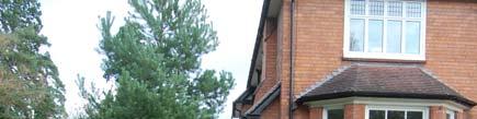
10 N WSM WSM17191 WSM34875 WSM01932 WSM01933 WSM03303 WSM01832 Site Alvechurch WSM31962 WSM01831 WSM29061 WSM01830 WSM01829 WSM17709 WSM16713 WSM01232 WSM17221 SAM WSM km Fig 1 Site Location
11 N RADFORD ROAD Excavation The Moat House Trench observed Site of Bishop's Palace Alvechurch River Arrow m 1:2000 Dogleg to house The Moat House Trench observed Manhole area m 1:200 Fig 2 Trench observed


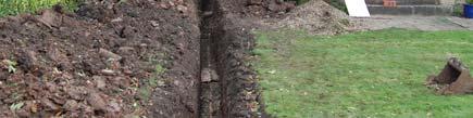

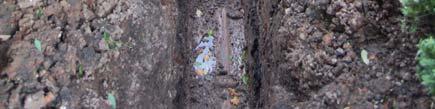
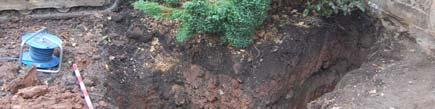
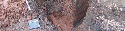
12 Fig 3 Trench looking north-east Fig 4 Trench looking north-east (detail) Fig 5 New manhole area looking north-east, layers 1-4


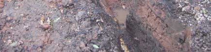
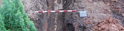
13 Fig 6 Dog-leg trench looking northeast Fig 7 Trench looking south-west
Cholesbury New House, Parrots Lane, Cholesbury, Buckinghamshire
 Cholesbury New House, Parrots Lane, Cholesbury, Buckinghamshire An Archaeological Watching Brief For Mr Martin Wood by Sean Wallis Thames Valley Archaeological Services Ltd Site Code PLC 06/135 March 2007
The Coach House, Mill Lane, Cookham, Berkshire
 The Coach House, Mill Lane, Cookham, Berkshire An Archaeological Watching Brief For Ms Sophia Butler by Stephen Hammond Thames Valley Archaeological Services Ltd Site Code CMC 03/104 October 2003 Summary
Excavations in a Medieval Market Town: Mountsorrel, Leicestershire,
 Excavations in a Medieval Market Town: Mountsorrel, Leicestershire, by John Lucas Mountsorrel is situated 12 kms north of Leicester and forms a linear settlement straddling the A6, Leicester to Derby road.
Land off Birdie Way, Rush Green, Hertford, Hertfordshire
 Land off Birdie Way, Rush Green, Hertford, Hertfordshire An Archaeological Evaluation for Bride Hall Development Limited by Sarah Coles Thames Valley Archaeological Services Site Code RGH00/ 01 January
Holyport Manor Special School, Highfield Lane, Cox Green, Maidenhead, Berkshire
 Holyport Manor Special School, Highfield Lane, Cox Green, Maidenhead, Berkshire An Archaeological recording action For CgMs Consulting by Jennifer Lowe Thames Valley Archaeological Services Ltd Site Code
Henderson Mess, RAF Halton, Buckinghamshire
 Henderson Mess, RAF Halton, Buckinghamshire An archaeological watching brief for Stepnell Ltd by Stephen Hammond Thames Valley Archaeological Services Ltd Site Code RHA03/85 October 2003 Summary Site name:
Archaeological Investigations Project South East Region SOUTHAMPTON 2/842 (C.80.C004) SU
 SU") SOUTHAMPTON City of Southampton 2/842 (C.80.C004) SU 4382 1336 125 BITTERNE ROAD WEST, SOUTHAMPTON Report on the Archaeological Evaluation Excavation at 125 Bitterne Road West, Southampton Russel, A. D
SOUTHAMPTON City of Southampton 2/842 (C.80.C004) SU 4382 1336 125 BITTERNE ROAD WEST, SOUTHAMPTON Report on the Archaeological Evaluation Excavation at 125 Bitterne Road West, Southampton Russel, A. D
Wheatlands House, Fleet Hill, Finchampstead, Berkshire
 Wheatlands House, Fleet Hill, Finchampstead, Berkshire An Archaeological Watching Brief For JCA International by James McNicoll-Norbury Thames Valley Archaeological Services Ltd Site Code WFF 08/26 August
Report on an archaeological watching brief at Thomas Lord Audley School, Monkwick, Colchester
 Report on an archaeological watching brief at Thomas Lord Audley School, Monkwick, Colchester July 2000 for WS Atkins Property Services Colchester Archaeological Trust 12 Lexden Road, Colchester, Essex
BRONZE AGE FIELD SYSTEM AT SOUTHAMPTON AIRPORT
 Proc. Hampshire Field Club Archaeol. Soc. 65, 2010, 1-6 (Hampshire Studies 2010) BRONZE AGE FIELD SYSTEM AT SOUTHAMPTON AIRPORT By J SULIKOWSKA With contributions by LORRAINE MEPHAM and CHRIS J STEVENS
Archaeological Watching Brief on land at Alpha, Gore Road, Eastry, Kent July 2010
 Archaeological Watching Brief on land at Alpha, Gore Road, Eastry, Kent July 2010 SWAT. Archaeology Swale and Thames Archaeological Survey Company School Farm Oast, Graveney Road Faversham, Kent ME13 8UP
An archaeological watching brief at the Sixth Form College, North Hill, Colchester, Essex
 An archaeological watching brief at the Sixth Form College, North Hill, Colchester, Essex July 2001 on behalf of Colchester Borough Council CAT project ref.: 01/7B Colchester Museum accession code: 2001.126
The Archaeology of Cheltenham
 The Archaeology of Cheltenham The archaeology collection of The Wilson contains a rich quantity of material relating to the prehistoric and Roman occupation of the North Cotswolds and parts of the Severn
Northamptonshire Archaeology
 Northamptonshire Archaeology A programme of archaeological observation, investigation and recording at St Andrews Church, Spratton, Northamptonshire Northamptonshire Archaeology 2 Bolton House Wootton
Archaeological Watching Brief at the Brick Stables and Wagon Lodge, Abbey Barns, Abbey Road, Faversham, Kent September 2010
 Archaeological Watching Brief at the Brick Stables and Wagon Lodge, Abbey Barns, Abbey Road, Faversham, Kent September 2010 SWAT. Archaeology Swale and Thames Archaeological Survey Company School Farm
An archaeological evaluation at 14 Vineyard Street, Colchester, Essex March 2006
 An archaeological evaluation at 14 Vineyard Street, Colchester, Essex March 2006 report prepared by Ben Holloway commissioned by Colchester Borough Council CAT project code: 06/4b Colchester Museums accession
Chiselbury Camp hillfort
 Chiselbury Camp hillfort Reasons for Designation Large univallate hillforts are defined as fortified enclosures of varying shape, ranging in size between 1ha and 10ha, located on hilltops and surrounded
FOUNDATIONS OF ARCHAEOLOGY A WALK IN VERNDITCH CHASE
 FOUNDATIONS OF ARCHAEOLOGY A WALK IN VERNDITCH CHASE 1. A Tale of two Long Barrows Long barrows were constructed as earthen or drystone mounds with flanking ditches and acted as funerary monuments during
Archaeological Monitoring at Ham Farm, Ham Road, Faversham, Kent
 Archaeological Monitoring at Ham Farm, Ham Road, Faversham, Kent NGR: 601750.0mE 162695.0mN Site Code HAM/WB/12 Report for A.J. Bray SWAT ARCHAEOLOGY Swale and Thames Archaeological Survey Company The
Wessex Archaeology. Little Stubbings, West Amesbury, Salisbury, Wiltshire. Archaeological Watching Brief. Ref:
 Wessex Archaeology Little Stubbings, West Amesbury, Salisbury, Wiltshire Ref: 63280.02 March 2007 LITTLE STUBBINGS, WEST AMESBURY, NR SALISBURY, WILTSHIRE ARCHAEOLOGICAL WATCHING BRIEF Prepared for: P
Gorse Stacks, Bus Interchange Excavations Interim Note-01
 Gorse Stacks, Bus Interchange Excavations 2015 Prepared for: Cheshire West & Chester Council Interim Note-01 1 Introduction & Summary Background Since c. 2000 investigations associated with redevelopment
Archaeological Evaluation Report
 Holywell House Osney Mead Oxford o a November 2007 Client: Knowles and Son Issue N o : 1 OA Job N o : 3826 Planning Ref N o : 02/01800/FUL NGR: SP 502 055 Client Name: Knowles and Son Client Ref No: Document
The Old Shire Horse Centre, Bath Road, Woolley Green, Maidenhead, Berkshire
 The Old Shire Horse Centre, Bath Road, Woolley Green, Maidenhead, Berkshire An Archaeological Watching Brief For Mr Derek Chesterman by Andrew Mundin Thames Valley Archaeological Services Ltd Site Code
An archaeological excavation at 193 High Street, Kelvedon, Essex September 2009
 An archaeological excavation at 193 High Street, Kelvedon, Essex September 2009 report prepared by Ben Holloway and Howard Brooks on behalf of Marden Homes CAT project ref.: 09/4g NGR: TL 8631 1913 (c)
An archaeological watching brief on land adjacent to 50 Rosebery Avenue, Colchester, Essex May/June 2003
 An archaeological watching brief on land adjacent to 50 Rosebery Avenue, Colchester, Essex May/June 2003 report prepared by C Crossan on behalf of Highfield Homes Ltd NGR: TM 0035 2500 CAT project ref.:
Newbold Hall, Rochdale. An Archaeological Excavation
 School of the Built Environment CUBE Building, University of Salford 113-115 Portland Street Manchester M1 6DW Tel: 0161 295 3818 Email: m.d.nevelle@salford.ac.uk Web: www.cfaa.co.uk Newbold Hall, Rochdale.
East Midlands Region LEICESTER 3/16 (E.62.A010) SK
 SK") LEICESTER City of Leicester 3/16 (E.62.A010) SK 5853 0433 12 NEW ST., CASTLE WARD, LEICESTER Cottage to the Rear of 12 New St., Castle Ward, Leicester - A Photographic Survey and Archaeological Watching
LEICESTER City of Leicester 3/16 (E.62.A010) SK 5853 0433 12 NEW ST., CASTLE WARD, LEICESTER Cottage to the Rear of 12 New St., Castle Ward, Leicester - A Photographic Survey and Archaeological Watching
ROUKEN GLEN: BANDSTAND 2015 DATA STRUCTURE REPORT
 ROUKEN GLEN: BANDSTAND 2015 DATA STRUCTURE REPORT Author (s) Ian Hill Editors Report Date June 2015 Working Partners Funders Phil Richardson East Renfrewshire Council East Renfrewshire Council, Heritage
S E R V I C E S. Land to the rear of Ashdown, Basingstoke Road, Spencers Wood, Reading, Berkshire. Archaeological Evaluation.
 T H A M E S V A L L E Y ARCHAEOLOGICAL S E R V I C E S Land to the rear of Ashdown, Basingstoke Road, Spencers Wood, Reading, Berkshire Archaeological Evaluation by Susan Porter Site Code: ASW12/21 (SU
o a London Borough of Barnet Stoney Wood Lake Silk Stream Flood Alleviation Scheme Archaeological Watching Brief Report Oxford Archaeology
 Silk Stream Flood Alleviation Scheme Stoney Wood Lake London Borough of Barnet Archaeological Watching Brief Report o a Oxford Archaeology November 2004 Client: Halcrow on behalf of Environment Agency
Afon Adda Refurbishment Bangor
 Afon Adda Refurbishment Bangor Archaeological Assessment Revised Report GAT Project No. 1876 Report No. 628 April 2006 Ymddiriedolaeth Archaeolegol Gwynedd Gwynedd Archaeological Trust Craig Beuno, Ffordd
Aylesbury Masonic Hall, Ripon Street, Aylesbury, Buckinghamshire
 Aylesbury Masonic Hall, Ripon Street, Aylesbury, Buckinghamshire An Archaeological Recording Action for Wakefield Building Services by Andrew Mundin Thames Valley Archaeological Services Ltd Site Code
Trench 91 revealed that the cobbled court extends further to the north.
 Report on the 2013 Gournia Excavations The 2013 excavations at Gournia were conducted June 17 July 26 under the aegis of the American School of Classical Studies at Athens and the supervision of the KD
Downton, Wiltshire: archaeology and history (notes for visitors prepared by the Royal Archaeological Institute, 2017)
") Downton, Wiltshire: archaeology and history (notes for visitors prepared by the Royal Archaeological Institute, 2017) The River Avon leaves Wiltshire in Downton, a large parish that includes parts of the
Downton, Wiltshire: archaeology and history (notes for visitors prepared by the Royal Archaeological Institute, 2017) The River Avon leaves Wiltshire in Downton, a large parish that includes parts of the
Following the Worcester & Birmingham Canal Feeder in Kings Norton Visiting Lifford Reservoir & Wychall Reservoir. Lifford
 Worcester-Birmingham & Droitwich Canals Society SUMMER WALK Following the Worcester & Birmingham Canal Feeder in Kings Norton Visiting Lifford Reservoir & Wychall Reservoir Lifford Reservoir Wychall Reservoir
Florence House, High Street, Hurley, Berkshire
 Florence House, High Street, Hurley, Berkshire An Archaeological Watching Brief For Mr Michael Waterhouse by Jo Pine Thames Valley Archaeological Services Ltd Site Code FHH04/52 May 2004 Summary Site name:
Street Sweeper Dump Site, RAF Lakenheath ERL 160
 ARCHAEOLOGICAL MONITORING REPORT Street Sweeper Dump Site, RAF Lakenheath ERL 160 A REPORT ON THE ARCHAEOLOGICAL MONITORING, 2006 (Planning app. no. F/2006/0021/GOV) Jo Caruth Field Team Suffolk C.C. Archaeological
A FIELDWALKING PROJECT AT HOLLINGBURY, BRIGHTON. by JOHN FUNNELL
 Introduction A FIELDWALKING PROJECT AT HOLLINGBURY, BRIGHTON by JOHN FUNNELL Members of the Brighton and Hove Archaeological Society walked the field at Hollingbury during the months of December 1991 and
archaeological evaluation of sites to the west of the castle in 1988
 FLNT CASTLE archaeological evaluation of sites to the west of the castle in 1988 -.., - w -... " - Clwyd-Powys Archaeological Trust '.. - Flint Castle, Delyn: evaluation of sites west of the castle in
4. Bronze Age Ballybrowney, County Cork Eamonn Cotter
 4. Bronze Age Ballybrowney, County Cork Eamonn Cotter Illus. 1 Location map of the excavated features at Ballybrowney Lower (Archaeological Consultancy Services Ltd, based on the Ordnance Survey Ireland
Deddington Castle, Oxfordshire: A Summary of Excavations *
 Deddington Castle, Oxfordshire: A Summary of Excavations 1977 1979* R.J. Ivens for Queen s University, Belfast, and DoE Between 1947 and 1951 Prof. E.M. Jope carried out a series of rescue excavations
THE HEUGH LINDISFARNE
 LINDISFARNE COMMUNITY ARCHAEOLOGY THE HEUGH LINDISFARNE Archaeological excavations in June 2017 Invitation to volunteers THE HEUGH, LINDISFARNE, NORTHUMBERLAND: ARCHAEOLOGICAL EXCAVATIONS 2017 INTRODUCTION
IMTO Italian Mission to Oman University of Pisa 2011B PRELIMINARY REPORT (OCTOBER-DECEMBER 2011)
") IMTO Italian Mission to Oman University of Pisa 2011B PRELIMINARY REPORT (OCTOBER-DECEMBER 2011) The 2011B research campaign took place in the area around Salut from October, 19 th, to December, 16 th.
IMTO Italian Mission to Oman University of Pisa 2011B PRELIMINARY REPORT (OCTOBER-DECEMBER 2011) The 2011B research campaign took place in the area around Salut from October, 19 th, to December, 16 th.
Archaeological Investigations Project Yorkshire & Humberside Region NORTH YORKSHIRE 2/1113 (C.36.J002) SD
 SD") NORTH YORKSHIRE Craven 2/1113 (C.36.J002) SD 93607800 CRAY BECK, BUCKDEN, UPPER WHARFEDALE Cray Beck, The Archaeological Investigation of a Stone Feature Archetype Wensleydale : ArcheType Archaeological
NORTH YORKSHIRE Craven 2/1113 (C.36.J002) SD 93607800 CRAY BECK, BUCKDEN, UPPER WHARFEDALE Cray Beck, The Archaeological Investigation of a Stone Feature Archetype Wensleydale : ArcheType Archaeological
ARCHAEOLOGICAL S E R V I C E S. Phase 5, Grimsby Road, Cippenham, Slough, Berkshire. Archaeological Recording Action.
 T H A M E S V A L L E Y ARCHAEOLOGICAL S E R V I C E S Phase 5, Grimsby Road, Cippenham, Slough, Berkshire Archaeological Recording Action by Andy Taylor Site Code: GRC13/57 (SU 9493 7977) Phase 5, Eltham
Reservoir Tin workings
 The workings are quite over-grown and covered in moss, suggesting that they date to the earliest period of mining. This is supported by the fact that their head race was cut off by the reservoir (D49/47)
Manor Farm, Wilcot, Pewsey, Wiltshire
 Manor Farm, Wilcot, Pewsey, Wiltshire An Archaeological Evaluation for Mr W. Madiment by Helen Moore Thames Valley Archaeological Services Ltd Site Code MFP02/78 September 2002 Summary Site name: Manor
Remote Sensing into the Study of Ancient Beiting City in North-Western China
 Dingwall, L., S. Exon, V. Gaffney, S. Laflin and M. van Leusen (eds.) 1999. Archaeology in the Age of the Internet. CAA97. Computer Applications and Quantitative Methods in Archaeology. Proceedings of
Following the initial soil strip archaeology is sprayed up prior to planning and excavation
 Barton Quarry & Archaeology Over the past half century quarries have been increasingly highlighted as important sources of information for geologists, palaeontologists and archaeologists, both through
An archaeological evaluation at 19 Beverley Road, Colchester, Essex February 2003
 An archaeological evaluation at 19 Beverley Road, Colchester, Essex February 2003 report prepared by Carl Crossan on behalf of Mr G and Mrs H Prince NGR: TL 98655 24844 CAT project ref.: 03/2d Planning
Document History continued Revision: Date: Prepared by: Checked by: Approved by: Reason for Issue:
 Document History continued Revision: Date: Prepared by: Checked by: Approved by: Reason for Issue: 1.0 29/10/2013 Gary Evans Andy Shelley Richard Brown For Acceptance Fieldwork Report CRL Ltd, 2014 Fieldwork
The Yingtianmen Gate-site of the Sui and Tang Eastern Capital in Luoyang City
 Nandajie The Yingtianmen Gate-site of the Sui and Tang Eastern Capital in Luoyang City Tang Luoyang City-site Archaeological Team, Institute of Archaeology, Chinese Academy of Social Sciences Key words:
REPORT NUMBER 001 ARCHAEOLOGICAL DOWSING SURVEY BISHOPS SUTTON NEAR ALRESFORD HAMPSHIRE. D P BRYAN BA (Hons) MARCH 2012
 MARCH 2012") REPORT NUMBER 001 ARCHAEOLOGICAL DOWSING SURVEY AT BISHOPS SUTTON NEAR ALRESFORD HAMPSHIRE D P BRYAN BA (Hons) MARCH 2012 1 Table of Contents 1. Introduction 1.1 Project Background Page 2 1.2 Site Location
REPORT NUMBER 001 ARCHAEOLOGICAL DOWSING SURVEY AT BISHOPS SUTTON NEAR ALRESFORD HAMPSHIRE D P BRYAN BA (Hons) MARCH 2012 1 Table of Contents 1. Introduction 1.1 Project Background Page 2 1.2 Site Location
Architectural Analysis in Western Palenque
 Architectural Analysis in Western Palenque James Eckhardt and Heather Hurst During the 1999 season of the Palenque Mapping Project the team mapped the western portion of the site of Palenque. This paper
IKLAINA ARCHAEOLOGICAL PROJECT 2016 FIELD REPORT Michael B. Cosmopoulos
 IKLAINA ARCHAEOLOGICAL PROJECT 2016 FIELD REPORT Michael B. Cosmopoulos Introduction The overarching objective of the Iklaina project is to test existing hierarchical models of state formation in Greece
Jneneh in the Upper Wadi az-zarqa, in North Central Jordan, First Season 2011.
 Jneneh in the Upper Wadi az-zarqa, in North Central Jordan, First Season 2011. Khaled Douglas Jneneh is located in the north-western periphery of the city of Zarqa (grid ref. 250.88E 165.25N), in North
FORMER COUNTY OF SOUTH YORKSHIRE
 FORMER COUNTY OF SOUTH YORKSHIRE Barnsley 3/1883 (E.04.6010) SE 36491121 4 CHURCH HILL, ROYSTON 4 Church Hill, Royston, South Yorkshire. Archaeological Watching Brief (Report No. 868) O'Neill, R Leeds
E&M West Buildings Union Street, Aberdeen, AB10 1GD
 E&M West Buildings 32-38 Union Street, Aberdeen, AB10 1GD 30 November 2011 E&M West Buildings 32-38 Union Street, Aberdeen, AB10 1GD CONTENTS 1 INTRODUCTION 3 2 ARCHAEOLOGICAL BACKGROUND 4 3 THE WATCHING
Catridge Farm, Lacock, Wiltshire Remains of a Shrunken Settlement
 Catridge Farm, Lacock, Wiltshire Remains of a Shrunken Settlement Elaine Jamieson Discovery, Innovation and Science in the Historic Environment Research Report Series no. 90-2015 Research Report Series
CASTLE OF OLD WICK HISTORIC ENVIRONMENT SCOTLAND STATEMENT OF SIGNIFICANCE. Property in Care(PIC) ID: PIC282 Designations:
 ID: PIC282 Designations:") Property in Care(PIC) ID: PIC282 Designations: Scheduled Monument (SM90065) Taken into State care: 1957 (Guardianship) Last reviewed: 2004 HISTORIC ENVIRONMENT SCOTLAND STATEMENT OF SIGNIFICANCE CASTLE
Property in Care(PIC) ID: PIC282 Designations: Scheduled Monument (SM90065) Taken into State care: 1957 (Guardianship) Last reviewed: 2004 HISTORIC ENVIRONMENT SCOTLAND STATEMENT OF SIGNIFICANCE CASTLE
Looking north from the SW shieling site with Lub na Luachrach in the foreground
 Looking north from the SW shieling site with Lub na Luachrach in the foreground Upper Gleann Goibhre - Shieling sites Two shieling sites in the upper reaches of the Allt Goibhre were visited and recorded
FIELD BOUNDARIES, A MEDIEVAL STRUCTURE AND DEAD SHEEP AT IWADE, KENT
 FIELD BOUNDARIES, A MEDIEVAL STRUCTURE AND DEAD SHEEP AT IWADE, KENT Pre-Construct Archaeology Limited Unit 54, Brockley Cross Business Centre, 96 Endwell Road, Brockley, London SE4 2PD tel: 020 7732 3925
Hay Wood, Rowington and Baddesley Clinton - Warwickshire
 Hay Wood, Rowington and Baddesley Clinton - Warwickshire Starts at Lay-by alongside Hay Wood 2 hours 30 minutes 5.5miles 8.8km Leisurely ID: 0.683 Developed by: John Clift Checked by: Andy Page www.ramblersroutes.org
Addington Village Farm, Addington Village Road, London Borough of Croydon
 Addington Village Farm, Addington Village Road, London Borough of Croydon An Archaeological Desk-Based Assessment for Bewley Homes PLC by Steve Ford Thames Valley Archaeological Services Site Code ARC00/47
An archaeological watching brief at 97 High Street, Colchester, Essex March 2010
 An archaeological watching brief at 97 High Street, Colchester, Essex March 2010 report prepared by Donald Shimmin on behalf of Flying Trade Group plc CAT project ref.: 10/3a Colchester and Ipswich Museums
ARDESTIE EARTH HOUSE HISTORIC ENVIRONMENT SCOTLAND STATEMENT OF SIGNIFICANCE. Property in Care no: 24
 Property in Care no: 24 Designations: Scheduled Monument (SM90021) Taken into State care: 1953 (Guardianship) Last reviewed: 2004 HISTORIC ENVIRONMENT SCOTLAND STATEMENT OF SIGNIFICANCE ARDESTIE EARTH
ARCHAEOLOGICAL MONITORING OF THE ASHBY STREET DRAINAGE PROJECT, SAN ANTONIO, BEXAR COUNTY, TEXAS
 ARCHAEOLOGICAL MONITORING OF THE ASHBY STREET DRAINAGE PROJECT, SAN ANTONIO, BEXAR COUNTY, TEXAS Anne A. Fox and I. Waynne Cox / Center for Archaeological Research The University of Texas at San Antonio
I I I I LINDEN TO WOOD FORD SURVEY ITEMS OF HISTORICAL SIGNIFICANCE I I I I I I I I I I I I I
 LNDEN TO WOOD FORD SURVEY TEMS OF HSTORCAL SGNFCANCE ------------------------------------------------------------------------------ --- - CONTENTS OF THE REPORT 1.0 ntroduction to the Report 1.1 Parameters
CARLUNGIE EARTH HOUSE
 Property in Care (PIC) ID: PIC015 Designations: Scheduled Monument (SM90059) Taken into State care: 1953 (Guardianship) Last reviewed: 2004 HISTORIC ENVIRONMENT SCOTLAND STATEMENT OF SIGNIFICANCE CARLUNGIE
Provincial Archaeology Office Annual Review
 2017 Provincial Archaeology Office Annual Review Provincial Archaeology Office Department of Tourism, Culture, Industry and Innovation Government of Newfoundland and Labrador March 2018 Volume 16 A brief
Chapter 12 Route window W15 Dog Kennel bridge. Transport for London
 Chapter 12 Route window W15 DOG KENNEL BRIDGE 12 Route window W15 12.6 southwards to North Park Road and Richings Park Golf Course. To the west side of this route window is the built-up edge of Slough
CSG Annual Conference - Stirling - April St Andrews Castle
 St. Andrews Castle. The Fore Tower, one of the oldest parts of the castle, originally housing the castle s entrance, was much rebuilt 1385-1401. The entrance was moved to its present position in the 1500s.
OXFORD BEFORE THE UNIVERSITY The Late Saxon and Norman Archaeology of the Thames Crossing, the Defences and the Town
 OXFORD BEFORE THE UNIVERSITY The Late Saxon and Norman Archaeology of the Thames Crossing, the Defences and the Town Edited by Anne Dodd with major contributions by Maureen Mellor, Julian Munby, Mark Robinson
Archaeological Investigations Project East Midlands Region NORTHAMPTONSHIRE
 NORTHAMPTONSHIRE 2/92 (C.34.A002) WAKEFIELD LODGE Wakefield Lodge, Northamptonshire. Archaeological Walkover Survey Bashford, D & Croft, A Oxford : Oxford Archaeology, 2001, 15pp, figs, tabs, refs Work
The History of a Floodplain Meadow Bridget Smith
 The History of a Floodplain Meadow Bridget Smith I have lived in the village of Hemingford Grey near the River Great Ouse since 1976 and, like many others, walked the 1½ km into St Ives by the ancient
In 2014 excavations at Gournia took place in the area of the palace, on the acropolis, and along the northern edge of the town (Fig. 1).
.") Gournia: 2014 Excavation In 2014 excavations at Gournia took place in the area of the palace, on the acropolis, and along the northern edge of the town (Fig. 1). In Room 18 of the palace, Room A, lined
Gournia: 2014 Excavation In 2014 excavations at Gournia took place in the area of the palace, on the acropolis, and along the northern edge of the town (Fig. 1). In Room 18 of the palace, Room A, lined
An archaeological watching brief on a new cable trench at the Abbey Field sports pitches, Circular Road North, Colchester, Essex October 2006
 An archaeological watching brief on a new cable trench at the Abbey Field sports pitches, Circular Road North, Colchester, Essex report prepared by Ben Holloway on behalf of Atkins Defence CAT project
Monitoring Report No. 278
 Roe Valley Country Park Hydroelectric Restoration Scheme Roe Valley Country Park Largy townland County Derry AE/14/30 Ruth Logue Site Specific Information Site location: Roe Valley Country Park, 41 Dogleap
TH E FIRST SEASON of investigations at the
 QUSEIR AL-QADIM Janet H. Johnson & Donald Whitcomb TH E FIRST SEASON of investigations at the ancient port of Quseir al-qadim on the Red Sea in Egypt took place in winter, 1978; the investigations were
COSTOCK. Location and boundaries. is bounded to the north by Bunny, to the east by Wysall, to the south by Rempstone and to the west
 VCH Nottinghamshire On-line Texts in Progress This version: January 2013 Author: Sheila Leeds COSTOCK Location and boundaries The ancient parish of Costock occupies 1,688 acres 1 about 9½ miles south of
Revision: Date: Prepared by: Checked by: Approved by: Reason for Issue: Nick Elsden (MOLA) Nick Elsden (MOLA) Page 2
 Nick Elsden (MOLA) Page 2") This document contains proprietary information. No part of this document may be reproduced without prior written consent from the chief executive of Crossrail Ltd. Revision: Date: Prepared by: Checked
This document contains proprietary information. No part of this document may be reproduced without prior written consent from the chief executive of Crossrail Ltd. Revision: Date: Prepared by: Checked
oi.uchicago.edu TALL-E BAKUN
 TALL-E BAKUN ABBAS ALIZADEH After I returned in September 1991 to Chicago from Cambridge, Massachusetts, I began preparing for publication the results of 1937 season of excavations at Tall-e Bakun, one
Specification for Grip blocking using Peat Dams
 Technical Guidance Note 1 Specification for Grip blocking using Peat Dams 1. Introduction Moorland drains (grips) have been dug across much of the Yorkshire upland peatlands. Many of these grips have become
Radnorshire Historic Settlements: Earthwork Survey
 THE CLWYD POWYS ARCHAEOLOGICAL TRUST I., ; I./ "oh';;: Radnorshire Historic Settlements: Earthwork Survey 1995-6 ;--- - ~.'l:1 ';, CPAT Report No 169 CPAT Report No 169 Radnorshire Historic Settlements:
Friends Meeting House, Hitchin. 1 Paynes Park, Hitchin, Hertfordshire, SG5 1EH. National Grid Reference: TL Statement of Significance
 Friends Meeting House, Hitchin 1 Paynes Park, Hitchin, Hertfordshire, SG5 1EH National Grid Reference: TL 18282 29279 Statement of Significance A meeting house of 1957 designed by Paul V. Mauger and erected
An archaeological excavation and watching brief at the Musket Club, Homefield Road, Colchester, Essex December 2004-February 2005
 An archaeological excavation and watching brief at the Musket Club, Homefield Road, Colchester, Essex December 2004-February 2005 report prepared by Howard Brooks on behalf of RMPA and the MoD CAT project
Road Barn Farm, Wendover
 Road Barn Farm, Wendover Buckinghamshire Archaeological Society HISTORIC BUILDINGS REPORT / October 2012 including HS2 high-speed rail line impact assessment SURVEY, RESEARCH AND REPORT: Stewart Moir,
New Archaeological Discoveries South of the Hanyuan Hall at the Daming Palace of Tang Dynasty
 New Archaeological Discoveries South of the Hanyuan Hall at the Daming Palace of Tang Dynasty The Xi an Tang City Archaeology Team, IA, CASS Key words: Imperial Palaces-China-Tang Dynasty Hanyuan Hall
Carisbrooke. Fig. 1. Carisbrooke Castle shell-keep, c with added gatehouse and portcullis c
 Fig. 1. Carisbrooke Castle shell-keep, c. 1130-40 with added gatehouse and portcullis c. 1335. 4. Carisbrooke The castle s founder, William fitzosbern, built an enclosure castle soon after the Norman Conquest.
Boddington Farm. Luddington Stratford-Upon-Avon Warwickshire
 Boddington Farm Luddington Stratford-Upon-Avon Warwickshire Boddington Farm LUDDINGTON STRATFORD-UPON-AVON WARWICKSHIRE CV37 9SD An attractive village farmhouse in need of renovation and courtyard development
Department of Tourism, Culture and Recreation Provincial Archaeology Office 2012 Archaeology Review February 2013 Volume 11
 Department of Tourism, Culture and Recreation Provincial Archaeology Office 2012 Archaeology Review February 2013 Volume 11 Area 14 of FjCa-14 in Sheshatshiu, portion of feature in southeast corner of
PONTOP SMITHY DIPTON, COUNTY DURHAM
 PONTOP SMITHY DIPTON, COUNTY DURHAM ~ ARCHAEOLOGICAL EXCAVATION ~ OCTOBER 2016 Prepared for: Land of Oak & Iron Landscape Partnership By: The Archaeological Practice Ltd. Project code: AP 16/43 Stage:
South East Region SOUTHAMPTON 3/1050 (E.80.H006) SU
 SU") SOUTHAMPTON 3/1050 (E.80.H006) SU 43351328 16 HAWKESWOOD ROAD Report on the Archaeological Observations at 16 Hawkeswood Road, Bitterne Manor Russil, A & Smith, M Southampton : Southampton City Council
SOUTHAMPTON 3/1050 (E.80.H006) SU 43351328 16 HAWKESWOOD ROAD Report on the Archaeological Observations at 16 Hawkeswood Road, Bitterne Manor Russil, A & Smith, M Southampton : Southampton City Council
Bootham Bar, York City Walls. (John Oxley FSA, City Archaeologist)
") W a l l e d C i t i e s & O p e n S o c i e t i e s : M a n a g i n g H i s t o r i c W a l l s i n U r b a n W o r l d H e r i t a g e P r o p e r t i e s Siena, Italy. 26-27 January 2017 Bootham Bar,
W a l l e d C i t i e s & O p e n S o c i e t i e s : M a n a g i n g H i s t o r i c W a l l s i n U r b a n W o r l d H e r i t a g e P r o p e r t i e s Siena, Italy. 26-27 January 2017 Bootham Bar,
Appendix - Restormel
 Fig. 1. Restormel castle, from the west. Stonework substantially late 13 th & early 14 th century. Appendix - Restormel 21. Restormel The site was acquired by Richard, earl of Cornwall (d. 1272) and was
NORTH YORKSHIRE 2/1340 (C ) SE
 SE") NORTH YORKSHIRE Craven 2/1339 (C.36.6001) SD 97606975 SD 94507750 KILNSEY TO BUCKDEN WATER PIPELINE Kilnsey to Buckden Water Pipeline, North Yorkshire. Geophysical Survey (Report no. 841) Webb, A Leeds
NORTH YORKSHIRE Craven 2/1339 (C.36.6001) SD 97606975 SD 94507750 KILNSEY TO BUCKDEN WATER PIPELINE Kilnsey to Buckden Water Pipeline, North Yorkshire. Geophysical Survey (Report no. 841) Webb, A Leeds
PORTISHEAD BRANCH LINE PRELIMINARY ENVIRONMENTAL INFORMATION REPORT VOLUME 4 APPENDIX Water Receptors
 PORTISHEAD BRANCH LINE PRELIMINARY ENVIRONMENTAL INFORMATION REPORT APPENDIX 17. 3 Water Receptors Contents Section Page 1 Water Receptors... 1-1 1.1 Surface Water Features/Receptors in the Study Area
Chapter 4 Research on Block 13, Lots 3 and 4
 Chapter 4 Research on Block 13, Lots 3 and 4 George Calfas History Block 13, Lots 3 and 4 Oral history and the written record Squire McWorter acquired the deed to Block 13, Lots 3 and 4 in 1854. Squire
WALKS AROUND WOODHURST
 WALKS AROUND WOODHURST With Walks To Woodhurst from North St. Ives Woodhurst is situated on the verge of an elevated tract of table land four miles north of St. Ives. Its footpaths vary from leafy lanes
Desk Based Assessment
 DRAFT Land to the south-east of St Mary's Church Brampton Huntingdonshire Desk Based Assessment February 2010 Client: Savills OA East Report No: 1161 OASIS No: Oxfordar3-72032 NGR: TL 2150 7060 Desk Based