An archaeological watching brief at 97 High Street, Colchester, Essex March 2010
|
|
|
- Angel Carpenter
- 5 years ago
- Views:
Transcription
1 An archaeological watching brief at 97 High Street, Colchester, Essex March 2010 report prepared by Donald Shimmin on behalf of Flying Trade Group plc CAT project ref.: 10/3a Colchester and Ipswich Museums accession code: COLEM NGR: TL Colchester Archaeological Trust 12 Lexden Road, Colchester, Essex CO3 3NF tel.: (01206) tel./fax: (01206) CAT Report 587 September 2011
2 Summary An archaeological watching brief took place at 97 High Street, Colchester, Essex during the machine-excavation of a series of test-pits by the developer. The remains of the south precinct wall of the Roman Temple of Claudius were uncovered close to the modern ground-level in the southern part of the site. Little of archaeological significance was reached in the northern part of the site, where the ground-level had been considerably made-up in modern times. Introduction (Fig 1) An archaeological watching brief was carried out on behalf of Flying Trade Group plc at 97 High Street, Colchester, Essex. This involved the monitoring and recording of a series of test-pits that were excavated by the developer prior to redevelopment of the site. The watching brief was undertaken by the Colchester Archaeological Trust (CAT) in March It followed a brief (CBC 2010) written by Colchester Borough Council s Archaeological Officer (CBCAO). The site is situated in Colchester town centre, at the rear of properties on the north side of the High Street, at NGR TL It lies to the south of the castle bailey and on the western side of a narrow lane known as Crowther s Entry. The existing property consists of a late 1960s' office block with car-parking on the ground floor and with a yard to the south. The site covers an area of approximately 315 sq m. This report follows the standards set out in Colchester Borough Council s Guidelines on standards and practices for archaeological fieldwork in the Borough of Colchester (CIMS 2008a), and also those in the Institute for Archaeologists Standard and guidance for an archaeological watching brief (IfA 2008a) and Standard and guidance for the collection, documentation, conservation and research of archaeological materials (IfA 2008b). The guidance contained in English Heritage s Management of Research Projects in the Historic Environment (MoRPHE 2006), and in the documents Research and archaeology: a framework for the Eastern Counties 1. Resource assessment (EAA 3), Research and archaeology: a framework for the Eastern Counties 2. Research agenda and strategy (EAA 8), and Standards for field archaeology in the East of England (EAA 14), was also followed. Archaeological background (Fig 1) The site is located in Insula 22 of the Roman town and is in an area of outstanding archaeological interest. An archaeological excavation took place on the site in 1964 and revealed part of the well-preserved south precinct wall of the Roman Temple of Claudius (1964 excavation on Fig 1). Even after the depredations of Norman stone robbers, the foundation platform survived to a width of 15 feet (4.57 m). It was surmounted by the remains of pier bases for a large arcaded screen (Hebditch 1971, 122), and also by a series of later blocking walls (ibid, 122-3). To the south of the precinct wall, in a trench dug also in 1964 along the western side of the site, traces of several phases of west-east Roman drains were uncovered. The well-preserved northern side of one of these drains, constructed of brick set in opus signinum, was exposed in 2006 during rebuilding work along the southern edge of the site (CAT Report 440; 2006 trenches on Fig 1). The 1964 excavations confirmed the results of archaeological work carried out nearby in 1931 and 1953 (Hull 1955; Hull 1958, ). The 1931 excavation revealed, immediately to the east of the site, the remains of the western part of a monumental arch centrally placed in the south precinct wall (1931 excavation on Fig 1; the 1953 site lies beyond the area of Fig 1). Part of the archway was also uncovered in evaluation trenches at the rear of High Street in 2006 (CAT Reports 360 & 380; 2006 evaluation trenches on Fig 1). 1
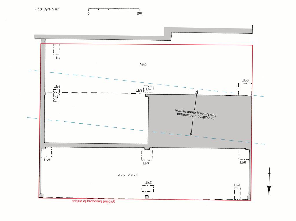
3 One of the reasons why the south precinct wall was so well-preserved was because it was insulated by the Norman inner bailey rampart which was piled up on top of it. The rampart was surmounted by a curtain wall, which was probably built in the 12th century and replaced an earlier timber palisade (VCH 9, 244). The digging of the inner bailey ditch to the south of the rampart necessitated the diversion of the High Street southwards, and the resulting curve in the street is still visible today. As a result of later activity, the remains of the curtain wall and much of the rampart were destroyed, while the bailey ditch was backfilled and built over (Hebditch 1971, 121; Drury 1983, 407-8). The footprint of the proposed building lies across the line of the Roman temple south precinct wall. Aims The aims of the watching brief were to identify and record the depth, extent and condition of any archaeological remains uncovered in the test-pits, and to assess the date and significance of these remains. Methods (Fig 2) Nine test-pits (TP1-TP9) were dug by the developer using a mechanical excavator. This was done primarily in order to gain information on the foundations of the existing building, as the intention was to retain its structural frame. TP1-TP5 were dug in the northern part of the site, adjacent to the castle bailey. TP6-TP9 were dug in the lower, southern part of the site, accessed off Crowther s Entry. The height of the modern ground-level in the castle bailey is approximately 26.3 m AOD, while that in the yard to the south is 25.2 m AOD. Monitoring and recording of the test-pits were carried out by CAT on 2nd-3rd March Following the breaking-out of the existing concrete surfaces (L1), the deposits in the trenches were progressively stripped under the supervision of a CAT archaeologist. Machine-excavation continued until archaeologicallysignificant deposits were reached. Where no such deposits were found, machine-excavation continued until the developer was satisfied with the depth of the test-pits, or until the safe working limit of the machine arm was reached, or until intractable obstacles were encountered. The test-pits varied in size, but were usually just over 1 m in length and at least 0.6 m wide. The approximate depths of the test-pits were as follows: TP1: 1.30 m TP2: 1.70 m TP3: 1.90 m TP4: 1.20 m TP5: 1.15 m TP6: 0.60 m TP7: 1.15 m TP8: 1.10 m TP9: 0.55 m The developer gave CAT staff time to investigate, clean and record any archaeological remains uncovered, and to collect up the finds unearthed. However, this work was constrained by health and safety considerations. Thus, due to the depth and unstable sides of the test-pits in the northern part of the site, most of the recording here had to be done from the modern ground-level looking down into the trench. Also, in the southern part of the site, it was not possible to investigate TP8 in detail due to the proximity of asbestos, although the removal of this by the developer was in hand. Individual records of archaeological contexts, such as layers or features, as well as finds, were entered on CAT pro-forma record sheets. Plans were drawn at 1:20 and section drawings were made at 1:10. Standard record shots of the test-pits were taken on a digital camera. Further information on the recording methods used can be found in the CAT document Policies and procedures (CAT 2006), and detailed notes on the stratigraphy in the test-pits are available in the site archive. 2
4 Results The natural subsoil was not reached in the test-pits. Previous investigations in the southern part of the site suggest that it lay approximately 1.7 m below the modern yard surface (23.5 m AOD), and consisted of sand and gravel sealed in places by shallow pockets of cover loam (CAT Report 440, fig 3). Roman south precinct wall (Fig 2) Part of a large Roman wall or foundation (F1) was uncovered in TP6. This was constructed of a hard pale brown mortar containing fragments of stone and Roman brick/tile. It lay approximately 0.4 m below the modern yard surface (24.8 m AOD). No edges were revealed to confirm its alignment. However, it probably formed part of the south precinct wall of the Temple of Claudius. Its proximity to the modern yard surface suggests that F1 may have belonged to a blocking wall or pier-base on top of the foundation platform rather than to the platform itself. A thin, dark greyish-brown, post-roman deposit (L3) lay between F1 and the modern concrete surface (L1). A small quantity of Roman brick/tile fragments was recovered from the machine spoil from TP6. A large lump of limestone, with a roughly dressed face, was also found in the spoil. It was photographed but retained on site. These finds probably came from L3, but most or all of them are likely to originally derive from the south precinct wall. Part of a hard, pale brown layer of mortar (F2) was uncovered in TP8. This contained stone fragments and lay m below the modern yard surface ( m AOD). It was not possible to examine F2 in detail, due to the proximity of asbestos. No edges were visible. The position and depth of F2 suggest that it probably formed the top of the foundation platform of the south precinct wall, close to its southern edge. Alternatively it could been part of a concrete apron immediately to the south of the arcade wall (Hebditch 1971, 118). Other Roman deposits (Fig 2) The mortared surface F2 in TP8 was sealed by a brown gravelly deposit (L6), m thick. This contained a few fragments of stone, Roman brick/tile and opus signinum. It was probably Roman in date, but did not appear to be metalling. Similar layers were found during earlier investigations nearby (Hull 1958, 65; Hebditch 1971, ; CAT Report 440, 2-3). They were perhaps make-up layers or material scraped up from the east-west street to the south. The gravelly deposit L6 in TP8 was sealed by post-roman topsoil or dark earth (L4). A brownish layer, similar to L6 in TP8, was also uncovered in TP7. It lay at about the same depth, 0.75 m (24.45 m AOD), below the modern yard surface. It was at least 0.30 m thick and contained fragments of stone, Roman brick/tile, mortar and opus signinum. It was also sealed by post-roman dark earth (L4). Trowelling in the south-western corner of TP7 revealed some opus signinum at a depth of just over 1 m below the modern yard surface. This may have been in situ, and could have been part of an east-west Roman drain. Several fragments of Roman building materials, including part of a column brick and a piece of Purbeck marble, were recovered from the machine spoil from TP7. These were probably residual in post-roman deposits. However, it is likely that the fragments originally derive from the south precinct wall or from associated Roman deposits nearby. Post-Roman deposits (Fig 2) The only significant archaeological deposit reached in the northern part of the site was in TP3 at a depth of 1.75 m below the modern ground-level (approximately m AOD). This consisted of a brownish layer (L5), which contained abundant oyster shells, some mortar fragments, and a few pieces of Roman brick/tile. It was sealed by dark earth (L4). These deposits survived only in the northern part of TP3, as they were cut away over the southern part of the test-pit by the foundation trench for the existing east-west brick wall. 3
5 The part of L5 uncovered in TP3 lay approximately 1 m north of the Roman south precinct wall and 0.25 m below the level of F1 in TP6. It was perhaps the fill of a medieval or later pit cut into the rear of the Norman rampart. Dark greyish-brown post-roman topsoil or dark earth (L4; CAR 3, 92) was observed in several test-pits. In TP3, in the northern part of the site, it appeared to lie between 1.15 and 1.75 m below the modern ground-level. In TP7 and TP8, in the southern part of the site, it was more truncated, lying roughly between 0.35 and 0.75 m below the modern ground-level. Sealing L4 in TP3, and also observed in TP2, there was a lighter, more mixed layer of dump/topsoil (L3), approximately 0.5 m thick. This was probably of post-medieval or modern date, and may have been redeposited. Similar deposits, but only approximately 0.2 m thick, were recorded in TP6 and TP7 in the southern part of the site. Extensive layers of modern rubble make-up (L2), approximately 1.15 m thick, were noted in all the test-pits in the northern part of the site. These were deeper up against the brick foundations of the existing building, where they formed the backfill of the modern foundation trenches. The make-up consisted largely of fragments of brick, concrete and stone. A similar deposit, 0.35 m thick, was recorded in TP9, where it sealed a modern concrete surface. In TP1, TP4, TP5 and TP9 only modern deposits were observed. The existing surfaces (L1) were of reinforced concrete, m thick, and were in places bedded on a thin layer of sand. Finds A quantity of finds was recovered during the watching brief. They came from the machine spoil and were thus unstratified. Where appropriate, the finds were washed, marked and bagged according to context, in line with the recommendations in Standard and guidance for the collection, documentation, conservation and research of archaeological materials (IfA 2008b). A fragment of worked stone is described in this section. The remaining finds are listed by test-pit in Table 1 in the appendix, and further details are provided in the site archive. The worked stone A fragment of a Purbeck marble veneer slab was recovered from the machine spoil from TP7. It probably originally derives from the Roman south precinct wall. Fragments of Purbeck marble were found in the 1964 excavation on the site, reused in a Roman east-west drain (Hebditch 1971, 120 & 123). Fragments of Purbeck marble were also discovered in the 1953 excavation a short distance to the west of the site (Hull 1955, 45-6, 49). SF 1. (6) TP7, unstratified. Purbeck marble. A fragment of a veneer slab. Two straight edges at right-angles to each other, one surviving 155 mm long, the other 135 mm long. Mortar adhering to underside. Maximum dimensions 200 by 200 mm, maximum thickness 30 mm. Weight 2,203 g. Conclusions The property is located close to Colchester castle keep and the site of the Temple of Claudius in the heart of the historic town centre and in an area of outstanding archaeological interest. The test-pits highlighted the contrast between the northern and southern parts of this split-level site. Significant archaeological remains were located close to the modern ground-level in the lower, southern part of the site. These included part of the well-preserved south precinct wall of the Temple of Claudius. However, in the northern part of the site, the ground-level had been considerably made-up in recent times, and significant archaeological deposits were only reached in TP3 at a depth of approximately 1.75 m below the modern ground-level. 4
6 The impact of the proposed redevelopment on the archaeological remains needs to be minimised. In particular, any damage to the south precinct wall should be avoided. If some disturbance of the archaeological deposits surrounding the precinct wall is unavoidable, then these deposits should be excavated and recorded in advance of the proposed groundworks. Archive deposition The archive from the watching brief, including the site records, photographs and finds, will be permanently deposited with Colchester and Ipswich Museums under accession code COLEM , in accordance with Guidelines on the preparation and transfer of archaeological archives to Colchester and Ipswich Museums (CIMS 2008b) and Archaeological archives: a guide to best practice in creation, compilation, transfer and curation (IfA 2007). The archive includes a cardboard wallet containing the context sheets, site plans, a copy of the CBCAO brief, and notes on the test-pits and finds; a CD containing digital material including the site photographs; and two museum boxes containing the finds. Acknowledgements CAT is grateful to Flying Trade Group plc for commissioning and funding the watching brief and to the workmen for their help on site. The work was monitored by Martin Winter (CBCAO). Glossary AOD above Ordnance Survey datum point based on mean sea level at Newlyn, Cornwall CBCAO Colchester Borough Council s Archaeological Officer context specific location on an archaeological site, especially one where finds are made; usually a layer or a feature cover loam a natural, wind-blown deposit, probably formed towards the end of the last Ice Age dark earth post-roman topsoil; probably the result of long-term cultivation, refuse-disposal and pit-digging. feature an identifiable context, such as a pit, a wall or a post-hole IfA Institute for Archaeologists medieval period from AD 1066 to c AD 1500 modern period from c 1850 onwards to the present natural geological deposit undisturbed by human activity NGR National Grid Reference opus signinum Roman concrete with a pinkish appearance due to the addition of brick/tile fragments post-medieval period from c 1500 to c 1850 residual finds that were deposited earlier than the context in which they were found Roman the period from AD 43 to c AD 410 tegula flanged Roman roof tile (plural tegulae) UAD Urban Archaeological Database, maintained by Colchester and Ipswich Museums U/S unstratified, ie without a well-defined context References Note: all CAT reports (except DBAs) are available online in.pdf format at CAR Colchester Archaeological Report 3: Excavations at Lion Walk, Balkerne Lane, and Middleborough, Colchester, Essex, by P Crummy CAR Colchester Archaeological Report 7: Post-Roman pottery from excavations in Colchester , by J Cotter 5
7 CAR Colchester Archaeological Report 10: Roman pottery from excavations in Colchester, , by R P Symonds and S Wade, ed by P Bidwell and A Croom CAT 2006 Policies and procedures (Colchester Archaeological Trust) CAT Report 360 An archaeological evaluation rear of High Street, Colchester, Essex, January 2006, unpublished CAT archive report, by H Brooks, 2006 CAT Report 380 Stage 2 of an archaeological evaluation at the rear of High Street, Colchester, Essex, July 2006, unpublished CAT archive report, by D Shimmin, 2006 CAT Report 440 An archaeological watching brief at 99 High Street, Colchester, Essex, December 2006, unpublished CAT archive report, by D Shimmin, 2007 CBC 2010 Brief for archaeological attendance and recording (a watching brief), 97 High Street, Colchester, Essex, by M Winter CIMS 2008a Guidelines on standards and practice for archaeological fieldwork in the Borough of Colchester (CBC) CIMS 2008b Guidelines on the preparation and transfer of archaeological archives to Colchester and Ipswich Museums (CBC) Drury, P 1983 Aspects of the origins and development of Colchester Castle, in Archaeol J, 139 (1982), EAA Research and archaeology: a framework for the Eastern Counties 1. resource assessment, ed by J Glazebrook EAA Research and archaeology: a framework for the Eastern Counties 2. research agenda and strategy, ed by N Brown and J Glazebrook EAA Standards for field archaeology in the East of England, ed by D Gurney, ALGAO East Hebditch, M 1971 Excavations on the south side of the temple precinct at Colchester, Transactions of the Essex Archaeological Society, 3 (3rd series), part 1, Hull, M R 1955 The south wing of the Roman "forum" at Colchester: recent discoveries, in Transactions of the Essex Archaeological Society, 25, part 1, Hull, M R 1958 Roman Colchester, RRCSAL, 20 IfA 2007 Archaeological archives: a guide to best practice in creation, compilation, transfer and curation IfA 2008a Standard and guidance for an archaeological watching brief IfA 2008b Standard and guidance for the collection, documentation, conservation and research of archaeological materials MoRPHE 2006 Management of Research Projects in the Historic Environment (English Heritage) VCH A history of the County of Essex, 9: the Borough of Colchester, ed by J Cooper, The Victoria History of the Counties of England Appendix: list of finds by test-pit All weights are in grammes. Roman pottery fabric code follows that used in CAR 10 (identification by Stephen Benfield of CAT). Post-Roman pottery fabric codes follow those used in CAR 7 (identifications by Howard Brooks of CAT). Stone fragment examined by Dr Keith Oak of Havering Sixth Form College. Table 1: finds list. Test-pit Context Finds no Qty Description Weight (g) Comments 6
8 TP2 U/S 1 1 medieval pot handle 112 Fabric 21a, skillet handle, 15th-16th century 1 clay-pipe stem fragment 1 bore diameter: 3 mm 3 animal bone fragments 93 TP6 U/S 2 1 medieval pot sherd 42 Fabric 20, 12th-13th century 4 3 tegula flange fragments joining; other fragment with mortar over broken edge 2 Roman brick/tile fragments x 24 mm thick, with mortar adhering; 1 x 29 mm thick, with mortar over broken edge 1 Roman brick fragment 1, mm thick, with mortar over broken edge 1 fragment of cant brick 1, mm thick, mm wide, maximum surviving length 227 mm, with mortar adhering, probably postmedieval TP7 U/S 5 1 tegula flange fragment 1,100 with mortar over broken edge 1 Roman column brick fragment approx 2, mm thick, with mortar adhering 2 fragments of cant brick 1, mm thick, mm wide, maximum surviving lengths 135 mm & 202 mm, probably post-medieval 1 brick fragment 1, mm thick, mm wide, maximum surviving length 209 mm, with mortar adhering, post-medieval? 1 stone approx 5,000 TP8 U/S 3 1 Roman pot sherd 3 Fabric GX hard, whitish?marble, possibly dolomitic or travertine, unworked with honeycomb weathering, dimensions approx 200 x 90 mm Colchester Archaeological Trust 2011 Distribution list: Flying Trade Group plc Martin Winter (CBCAO) Essex Historic Environment Record, Essex County Council 7
9 Colchester Archaeological Trust 12 Lexden Road, Colchester, Essex CO3 3NF tel.: (01206) (01206) Checked by: Philip Crummy Date: Adams x c:/reports 11/97 high street/report587.doc 8
10
11
12 Essex Historic Environment Record/ Essex Archaeology and History Summary sheet Site address: 97 High Street, Colchester, Essex Parish: Colchester District: Colchester NGR: TL Site codes: CAT project - 10/3a Museum accession - COLEM Type of work: Watching brief Date of work: March 2010 Location of finds/curating museum: Colchester and Ipswich Museums Further seasons anticipated? Yes Site director/group: Colchester Archaeological Trust Size of area investigated: 8 sq m Funding source: Developer Related EHER and UAD nos: - Final report: Periods represented: CAT Report 587 and summary in EAH Roman Summary of fieldwork results: An archaeological watching brief took place at 97 High Street, Colchester, Essex during the machine-excavation of a series of test-pits by the developer. The remains of the south precinct wall of the Roman Temple of Claudius were uncovered close to the modern ground-level in the southern part of the site. Little of archaeological significance was reached in the northern part of the site, where the ground-level had been considerably made-up in modern times. Previous summaries/reports: Hebditch 1971 Keywords: Temple of Claudius, Roman, precinct wall Significance: * Author of summary: Donald Shimmin Date of summary: September 2011
An archaeological excavation at 193 High Street, Kelvedon, Essex September 2009
 An archaeological excavation at 193 High Street, Kelvedon, Essex September 2009 report prepared by Ben Holloway and Howard Brooks on behalf of Marden Homes CAT project ref.: 09/4g NGR: TL 8631 1913 (c)
An archaeological watching brief at the Sixth Form College, North Hill, Colchester, Essex
 An archaeological watching brief at the Sixth Form College, North Hill, Colchester, Essex July 2001 on behalf of Colchester Borough Council CAT project ref.: 01/7B Colchester Museum accession code: 2001.126
An archaeological watching brief on land adjacent to 50 Rosebery Avenue, Colchester, Essex May/June 2003
 An archaeological watching brief on land adjacent to 50 Rosebery Avenue, Colchester, Essex May/June 2003 report prepared by C Crossan on behalf of Highfield Homes Ltd NGR: TM 0035 2500 CAT project ref.:
An archaeological watching brief on a new cable trench at the Abbey Field sports pitches, Circular Road North, Colchester, Essex October 2006
 An archaeological watching brief on a new cable trench at the Abbey Field sports pitches, Circular Road North, Colchester, Essex report prepared by Ben Holloway on behalf of Atkins Defence CAT project
An archaeological evaluation at 19 Beverley Road, Colchester, Essex February 2003
 An archaeological evaluation at 19 Beverley Road, Colchester, Essex February 2003 report prepared by Carl Crossan on behalf of Mr G and Mrs H Prince NGR: TL 98655 24844 CAT project ref.: 03/2d Planning
An archaeological fieldwalking evaluation at Tile House Farm, Great Horkesley, Essex July-September 2005
 An archaeological fieldwalking evaluation at Tile House Farm, Great Horkesley, Essex commissioned by ADP Chartered Architects on behalf of The Ingleton Properties Ltd and Mersea Homes CAT project code:
An archaeological evaluation at 14 Vineyard Street, Colchester, Essex March 2006
 An archaeological evaluation at 14 Vineyard Street, Colchester, Essex March 2006 report prepared by Ben Holloway commissioned by Colchester Borough Council CAT project code: 06/4b Colchester Museums accession
An archaeological excavation and watching brief at the Musket Club, Homefield Road, Colchester, Essex December 2004-February 2005
 An archaeological excavation and watching brief at the Musket Club, Homefield Road, Colchester, Essex December 2004-February 2005 report prepared by Howard Brooks on behalf of RMPA and the MoD CAT project
Report on an archaeological watching brief at Thomas Lord Audley School, Monkwick, Colchester
 Report on an archaeological watching brief at Thomas Lord Audley School, Monkwick, Colchester July 2000 for WS Atkins Property Services Colchester Archaeological Trust 12 Lexden Road, Colchester, Essex
An archaeological evaluation at 1 York Road, Earls Colne, Essex March 2009
 An archaeological evaluation at 1 York Road, Earls Colne, Essex March 2009 report prepared by Ben Holloway and Howard Brooks on behalf of Mr Kurt Manders CAT project ref.: 09/3a NGR: TL 8575 2888 HEM project
Archaeological monitoring and recording at DSG (Defence Support Group), Flagstaff Road, Colchester, Essex, CO2 7SR
, Flagstaff Road, Colchester, Essex, CO2 7SR") Archaeological monitoring and recording at DSG (Defence Support Group), Flagstaff Road, Colchester, Essex, CO2 7SR October 2017 by Laura Pooley figures by Laura Pooley and Sarah Carter fieldwork by Nigel
Archaeological monitoring and recording at DSG (Defence Support Group), Flagstaff Road, Colchester, Essex, CO2 7SR October 2017 by Laura Pooley figures by Laura Pooley and Sarah Carter fieldwork by Nigel
Archaeological investigations in Museum Street, Colchester, Essex June-July 1986 and January-June 2010
 Archaeological investigations in Museum Street, Colchester, Essex June-July 1986 and January-June 2010 report prepared by Donald Shimmin on behalf of Colchester Borough Council and Mr F Mussi NGR: TL 9982
Archaeological Monitoring at Ham Farm, Ham Road, Faversham, Kent
 Archaeological Monitoring at Ham Farm, Ham Road, Faversham, Kent NGR: 601750.0mE 162695.0mN Site Code HAM/WB/12 Report for A.J. Bray SWAT ARCHAEOLOGY Swale and Thames Archaeological Survey Company The
Archaeological Watching Brief at the Brick Stables and Wagon Lodge, Abbey Barns, Abbey Road, Faversham, Kent September 2010
 Archaeological Watching Brief at the Brick Stables and Wagon Lodge, Abbey Barns, Abbey Road, Faversham, Kent September 2010 SWAT. Archaeology Swale and Thames Archaeological Survey Company School Farm
Archaeological Watching Brief on land at Alpha, Gore Road, Eastry, Kent July 2010
 Archaeological Watching Brief on land at Alpha, Gore Road, Eastry, Kent July 2010 SWAT. Archaeology Swale and Thames Archaeological Survey Company School Farm Oast, Graveney Road Faversham, Kent ME13 8UP
Holyport Manor Special School, Highfield Lane, Cox Green, Maidenhead, Berkshire
 Holyport Manor Special School, Highfield Lane, Cox Green, Maidenhead, Berkshire An Archaeological recording action For CgMs Consulting by Jennifer Lowe Thames Valley Archaeological Services Ltd Site Code
An archaeological watching brief on a BT cable trench from Head Street to Southway, Colchester, Essex August-October 2006
 An archaeological watching brief on a BT cable trench from Head Street to Southway, Colchester, Essex report prepared by Donald Shimmin on behalf of British Telecom NGR: TL 9940 2510 CAT project ref.:
The Old Shire Horse Centre, Bath Road, Woolley Green, Maidenhead, Berkshire
 The Old Shire Horse Centre, Bath Road, Woolley Green, Maidenhead, Berkshire An Archaeological Watching Brief For Mr Derek Chesterman by Andrew Mundin Thames Valley Archaeological Services Ltd Site Code
Wheatlands House, Fleet Hill, Finchampstead, Berkshire
 Wheatlands House, Fleet Hill, Finchampstead, Berkshire An Archaeological Watching Brief For JCA International by James McNicoll-Norbury Thames Valley Archaeological Services Ltd Site Code WFF 08/26 August
Archaeological recording at 1 Mossfield Close, Colchester, Essex, CO3 3RG
 Archaeological recording at 1 Mossfield Close, Colchester, Essex, CO3 3RG May 2017 by Dr Elliott Hicks figures by Sarah Carter fieldwork by Sarah Carter Commissioned by Paul Neville NGR: TL 98014 24940
East Midlands Region LEICESTER 3/16 (E.62.A010) SK
 SK") LEICESTER City of Leicester 3/16 (E.62.A010) SK 5853 0433 12 NEW ST., CASTLE WARD, LEICESTER Cottage to the Rear of 12 New St., Castle Ward, Leicester - A Photographic Survey and Archaeological Watching
LEICESTER City of Leicester 3/16 (E.62.A010) SK 5853 0433 12 NEW ST., CASTLE WARD, LEICESTER Cottage to the Rear of 12 New St., Castle Ward, Leicester - A Photographic Survey and Archaeological Watching
Wessex Archaeology. Little Stubbings, West Amesbury, Salisbury, Wiltshire. Archaeological Watching Brief. Ref:
 Wessex Archaeology Little Stubbings, West Amesbury, Salisbury, Wiltshire Ref: 63280.02 March 2007 LITTLE STUBBINGS, WEST AMESBURY, NR SALISBURY, WILTSHIRE ARCHAEOLOGICAL WATCHING BRIEF Prepared for: P
Northamptonshire Archaeology
 Northamptonshire Archaeology A programme of archaeological observation, investigation and recording at St Andrews Church, Spratton, Northamptonshire Northamptonshire Archaeology 2 Bolton House Wootton
Cholesbury New House, Parrots Lane, Cholesbury, Buckinghamshire
 Cholesbury New House, Parrots Lane, Cholesbury, Buckinghamshire An Archaeological Watching Brief For Mr Martin Wood by Sean Wallis Thames Valley Archaeological Services Ltd Site Code PLC 06/135 March 2007
ROUKEN GLEN: BANDSTAND 2015 DATA STRUCTURE REPORT
 ROUKEN GLEN: BANDSTAND 2015 DATA STRUCTURE REPORT Author (s) Ian Hill Editors Report Date June 2015 Working Partners Funders Phil Richardson East Renfrewshire Council East Renfrewshire Council, Heritage
o a London Borough of Barnet Stoney Wood Lake Silk Stream Flood Alleviation Scheme Archaeological Watching Brief Report Oxford Archaeology
 Silk Stream Flood Alleviation Scheme Stoney Wood Lake London Borough of Barnet Archaeological Watching Brief Report o a Oxford Archaeology November 2004 Client: Halcrow on behalf of Environment Agency
Aylesbury Masonic Hall, Ripon Street, Aylesbury, Buckinghamshire
 Aylesbury Masonic Hall, Ripon Street, Aylesbury, Buckinghamshire An Archaeological Recording Action for Wakefield Building Services by Andrew Mundin Thames Valley Archaeological Services Ltd Site Code
Land off Birdie Way, Rush Green, Hertford, Hertfordshire
 Land off Birdie Way, Rush Green, Hertford, Hertfordshire An Archaeological Evaluation for Bride Hall Development Limited by Sarah Coles Thames Valley Archaeological Services Site Code RGH00/ 01 January
The Coach House, Mill Lane, Cookham, Berkshire
 The Coach House, Mill Lane, Cookham, Berkshire An Archaeological Watching Brief For Ms Sophia Butler by Stephen Hammond Thames Valley Archaeological Services Ltd Site Code CMC 03/104 October 2003 Summary
Gorse Stacks, Bus Interchange Excavations Interim Note-01
 Gorse Stacks, Bus Interchange Excavations 2015 Prepared for: Cheshire West & Chester Council Interim Note-01 1 Introduction & Summary Background Since c. 2000 investigations associated with redevelopment
Archaeological Evaluation Report
 Holywell House Osney Mead Oxford o a November 2007 Client: Knowles and Son Issue N o : 1 OA Job N o : 3826 Planning Ref N o : 02/01800/FUL NGR: SP 502 055 Client Name: Knowles and Son Client Ref No: Document
Henderson Mess, RAF Halton, Buckinghamshire
 Henderson Mess, RAF Halton, Buckinghamshire An archaeological watching brief for Stepnell Ltd by Stephen Hammond Thames Valley Archaeological Services Ltd Site Code RHA03/85 October 2003 Summary Site name:
Florence House, High Street, Hurley, Berkshire
 Florence House, High Street, Hurley, Berkshire An Archaeological Watching Brief For Mr Michael Waterhouse by Jo Pine Thames Valley Archaeological Services Ltd Site Code FHH04/52 May 2004 Summary Site name:
Two recently-discovered Roman buildings in Colchester
 Essex Archaeology and History 23 (1992), 25-38 Two recently-discovered Roman buildings in Colchester by Stephen Benfield and Simon Garrod East Stockwell Street Early Roman occupation was observed in section
Archaeological evaluation at Building H11, Colchester Garrison Area A1 (former Meeanee & Hyderabad Barracks), Mersea Road, Colchester, Essex
, Mersea Road, Colchester, Essex") Archaeological evaluation at Building H11, Colchester Garrison Area A1 (former Meeanee & Hyderabad Barracks), Mersea Road, Colchester, Essex October 2013 report prepared by Ben Holloway and Howard Brooks
Archaeological evaluation at Building H11, Colchester Garrison Area A1 (former Meeanee & Hyderabad Barracks), Mersea Road, Colchester, Essex October 2013 report prepared by Ben Holloway and Howard Brooks
4. Bronze Age Ballybrowney, County Cork Eamonn Cotter
 4. Bronze Age Ballybrowney, County Cork Eamonn Cotter Illus. 1 Location map of the excavated features at Ballybrowney Lower (Archaeological Consultancy Services Ltd, based on the Ordnance Survey Ireland
BRONZE AGE FIELD SYSTEM AT SOUTHAMPTON AIRPORT
 Proc. Hampshire Field Club Archaeol. Soc. 65, 2010, 1-6 (Hampshire Studies 2010) BRONZE AGE FIELD SYSTEM AT SOUTHAMPTON AIRPORT By J SULIKOWSKA With contributions by LORRAINE MEPHAM and CHRIS J STEVENS
Archaeological Investigations Project South East Region SOUTHAMPTON 2/842 (C.80.C004) SU
 SU") SOUTHAMPTON City of Southampton 2/842 (C.80.C004) SU 4382 1336 125 BITTERNE ROAD WEST, SOUTHAMPTON Report on the Archaeological Evaluation Excavation at 125 Bitterne Road West, Southampton Russel, A. D
SOUTHAMPTON City of Southampton 2/842 (C.80.C004) SU 4382 1336 125 BITTERNE ROAD WEST, SOUTHAMPTON Report on the Archaeological Evaluation Excavation at 125 Bitterne Road West, Southampton Russel, A. D
Stage 1b archaeological evaluation, Alienated Land Area H, Colchester Garrison, Colchester, Essex January-February 2007
 Stage 1b archaeological evaluation, Alienated Land Area H, Colchester Garrison, Colchester, Essex report prepared by Howard Brooks and Ben Holloway on behalf of Taylor Woodrow CAT project code: 06/10d
S E R V I C E S. Land to the rear of Ashdown, Basingstoke Road, Spencers Wood, Reading, Berkshire. Archaeological Evaluation.
 T H A M E S V A L L E Y ARCHAEOLOGICAL S E R V I C E S Land to the rear of Ashdown, Basingstoke Road, Spencers Wood, Reading, Berkshire Archaeological Evaluation by Susan Porter Site Code: ASW12/21 (SU
FOREWORD. S. S. Frere. The Culver Street site in relation to the fortress (top) and the Roman city (below).
 and the Roman city (below).") THE BIG DIG BEGINS FOREWORD Colchester has always been seen as an important Roman site owing to its known status as a Roman colonia - the first of only four in the country - and owing to the presence there
THE BIG DIG BEGINS FOREWORD Colchester has always been seen as an important Roman site owing to its known status as a Roman colonia - the first of only four in the country - and owing to the presence there
Excavations in a Medieval Market Town: Mountsorrel, Leicestershire,
 Excavations in a Medieval Market Town: Mountsorrel, Leicestershire, by John Lucas Mountsorrel is situated 12 kms north of Leicester and forms a linear settlement straddling the A6, Leicester to Derby road.
Newbold Hall, Rochdale. An Archaeological Excavation
 School of the Built Environment CUBE Building, University of Salford 113-115 Portland Street Manchester M1 6DW Tel: 0161 295 3818 Email: m.d.nevelle@salford.ac.uk Web: www.cfaa.co.uk Newbold Hall, Rochdale.
Contents. Crossrail Limited RESTRICTED. Summary of LSS85 archive Broadgate Excavations C257-MLA-T1-XTC-C101_WS
 Summary of LSS85 archive Broadgate Excavations Contents 1 Purpose...4 2 Scope...4 3 Definitions...4 4 LSS85 Archive Summary Report...4 5 Summary Data - Burials found in Liverpool Street...5 6 Note from
IMTO Italian Mission to Oman University of Pisa 2011B PRELIMINARY REPORT (OCTOBER-DECEMBER 2011)
") IMTO Italian Mission to Oman University of Pisa 2011B PRELIMINARY REPORT (OCTOBER-DECEMBER 2011) The 2011B research campaign took place in the area around Salut from October, 19 th, to December, 16 th.
IMTO Italian Mission to Oman University of Pisa 2011B PRELIMINARY REPORT (OCTOBER-DECEMBER 2011) The 2011B research campaign took place in the area around Salut from October, 19 th, to December, 16 th.
In 2014 excavations at Gournia took place in the area of the palace, on the acropolis, and along the northern edge of the town (Fig. 1).
.") Gournia: 2014 Excavation In 2014 excavations at Gournia took place in the area of the palace, on the acropolis, and along the northern edge of the town (Fig. 1). In Room 18 of the palace, Room A, lined
Gournia: 2014 Excavation In 2014 excavations at Gournia took place in the area of the palace, on the acropolis, and along the northern edge of the town (Fig. 1). In Room 18 of the palace, Room A, lined
Archaeological Investigations Project Eastern Region. Essex 2/197 (C.22.F025) TL
 TL") Essex Braintree 2/197 (C.22.F025) TL 75502284 BLANDFORD HOUSE, 7 LONDON ROAD, BRAINTREE Blandford House, 7 London Road, Braintree, Essex Davis, E Chelmsford : Essex County Council Field Archaeology Unit,
Essex Braintree 2/197 (C.22.F025) TL 75502284 BLANDFORD HOUSE, 7 LONDON ROAD, BRAINTREE Blandford House, 7 London Road, Braintree, Essex Davis, E Chelmsford : Essex County Council Field Archaeology Unit,
Draft Report. 7. Excavations in the temenos gateway, Area (TG5) Author - D. A. Welsby Period 1-2. Period 1. Period 2. Derek A.
 Author - D. A. Welsby Period 1-2. Period 1. Period 2. Derek A.") 7. Excavations in the temenos gateway, Area (TG5) Derek A. Welsby When Griffith excavated the temples at Kawa in 1929-31, work followed by that of Macadam and Kirwan in the winter of 1935-6, the temenos
7. Excavations in the temenos gateway, Area (TG5) Derek A. Welsby When Griffith excavated the temples at Kawa in 1929-31, work followed by that of Macadam and Kirwan in the winter of 1935-6, the temenos
South East Region SOUTHAMPTON 3/1050 (E.80.H006) SU
 SU") SOUTHAMPTON 3/1050 (E.80.H006) SU 43351328 16 HAWKESWOOD ROAD Report on the Archaeological Observations at 16 Hawkeswood Road, Bitterne Manor Russil, A & Smith, M Southampton : Southampton City Council
SOUTHAMPTON 3/1050 (E.80.H006) SU 43351328 16 HAWKESWOOD ROAD Report on the Archaeological Observations at 16 Hawkeswood Road, Bitterne Manor Russil, A & Smith, M Southampton : Southampton City Council
IKLAINA ARCHAEOLOGICAL PROJECT 2016 FIELD REPORT Michael B. Cosmopoulos
 IKLAINA ARCHAEOLOGICAL PROJECT 2016 FIELD REPORT Michael B. Cosmopoulos Introduction The overarching objective of the Iklaina project is to test existing hierarchical models of state formation in Greece
Street Sweeper Dump Site, RAF Lakenheath ERL 160
 ARCHAEOLOGICAL MONITORING REPORT Street Sweeper Dump Site, RAF Lakenheath ERL 160 A REPORT ON THE ARCHAEOLOGICAL MONITORING, 2006 (Planning app. no. F/2006/0021/GOV) Jo Caruth Field Team Suffolk C.C. Archaeological
South East SOUTHAMPTON
 Southampton SOUTHAMPTON 3/1056 (E.80.M010) SU 44181114 SO19 7PE 1 FOREST VIEW, SOUTHAMPTON Report on the Archaeological Watching Brief at 1 Forest View, Southampton, SOU 1232 Leivers, M Southampton : Southampton
Monitoring Report No. 119
 SITE OF THE OMAGH WORKHOUSE AND FEVER HOSPITAL OMAGH COUNTY TYRONE LICENCE NO.: AE/07/29 BRIAN SLOAN 1 Site Specific Information Site Name: Omagh General Hospital Townland: Lisnamallard SMR No. : N/A State
Manor Farm, Wilcot, Pewsey, Wiltshire
 Manor Farm, Wilcot, Pewsey, Wiltshire An Archaeological Evaluation for Mr W. Madiment by Helen Moore Thames Valley Archaeological Services Ltd Site Code MFP02/78 September 2002 Summary Site name: Manor
ARCHAEOLOGICAL S E R V I C E S. Phase 5, Grimsby Road, Cippenham, Slough, Berkshire. Archaeological Recording Action.
 T H A M E S V A L L E Y ARCHAEOLOGICAL S E R V I C E S Phase 5, Grimsby Road, Cippenham, Slough, Berkshire Archaeological Recording Action by Andy Taylor Site Code: GRC13/57 (SU 9493 7977) Phase 5, Eltham
Archaeological Observation at The Bishop s Palace, Alvechurch, Worcestershire
 Warwickshire County Council THE MOAT HOUSE Archaeological Observation at The Bishop s Palace, Alvechurch, Worcestershire Chris Jones and Bryn Gethin Report 1059 December 2010 The Moat House: Archaeological
South East WEST SUSSEX 3/1146 (E ) SU
 SU") WEST SUSSEX Arun 3/1146 (E.45.6000) SU 97370032 'GREENFIELDS', MIDDLETON-ON-SEA 'Greenfields', Middleton-on-Sea, West Sussex. Archaeological Excavation Saunders, M J Reading : Thames Valley Archaeological
WEST SUSSEX Arun 3/1146 (E.45.6000) SU 97370032 'GREENFIELDS', MIDDLETON-ON-SEA 'Greenfields', Middleton-on-Sea, West Sussex. Archaeological Excavation Saunders, M J Reading : Thames Valley Archaeological
E&M West Buildings Union Street, Aberdeen, AB10 1GD
 E&M West Buildings 32-38 Union Street, Aberdeen, AB10 1GD 30 November 2011 E&M West Buildings 32-38 Union Street, Aberdeen, AB10 1GD CONTENTS 1 INTRODUCTION 3 2 ARCHAEOLOGICAL BACKGROUND 4 3 THE WATCHING
NORTH YORKSHIRE 2/1340 (C ) SE
 SE") NORTH YORKSHIRE Craven 2/1339 (C.36.6001) SD 97606975 SD 94507750 KILNSEY TO BUCKDEN WATER PIPELINE Kilnsey to Buckden Water Pipeline, North Yorkshire. Geophysical Survey (Report no. 841) Webb, A Leeds
NORTH YORKSHIRE Craven 2/1339 (C.36.6001) SD 97606975 SD 94507750 KILNSEY TO BUCKDEN WATER PIPELINE Kilnsey to Buckden Water Pipeline, North Yorkshire. Geophysical Survey (Report no. 841) Webb, A Leeds
Department of Tourism, Culture and Recreation Provincial Archaeology Office 2012 Archaeology Review February 2013 Volume 11
 Department of Tourism, Culture and Recreation Provincial Archaeology Office 2012 Archaeology Review February 2013 Volume 11 Area 14 of FjCa-14 in Sheshatshiu, portion of feature in southeast corner of
Archaeological Investigations Project Yorkshire & Humberside Region NORTH YORKSHIRE 2/1113 (C.36.J002) SD
 SD") NORTH YORKSHIRE Craven 2/1113 (C.36.J002) SD 93607800 CRAY BECK, BUCKDEN, UPPER WHARFEDALE Cray Beck, The Archaeological Investigation of a Stone Feature Archetype Wensleydale : ArcheType Archaeological
NORTH YORKSHIRE Craven 2/1113 (C.36.J002) SD 93607800 CRAY BECK, BUCKDEN, UPPER WHARFEDALE Cray Beck, The Archaeological Investigation of a Stone Feature Archetype Wensleydale : ArcheType Archaeological
N18 Ennis Bypass and N85 Western Relief Road. Site AR125, Clareabbey, Co. Clare
 N18 Ennis Bypass and N85 Western Relief Road Site AR125, Clareabbey, Co. Clare Final Archaeological Excavation Report for Clare County Council Licence No: 04E0023 by Graham Hull Job J04/02 (NGR 134366
PONTOP SMITHY DIPTON, COUNTY DURHAM
 PONTOP SMITHY DIPTON, COUNTY DURHAM ~ ARCHAEOLOGICAL EXCAVATION ~ OCTOBER 2016 Prepared for: Land of Oak & Iron Landscape Partnership By: The Archaeological Practice Ltd. Project code: AP 16/43 Stage:
An archaeological evaluation at Colchester Garrison Church, Military Road, Colchester, Essex April 2007
 An archaeological evaluation at Colchester Garrison Church, Military Road, Colchester, Essex April 2007 report prepared by Howard Brooks and Ben Holloway on behalf of the MoD CAT project code: 07/4b Colchester
archaeological evaluation of sites to the west of the castle in 1988
 FLNT CASTLE archaeological evaluation of sites to the west of the castle in 1988 -.., - w -... " - Clwyd-Powys Archaeological Trust '.. - Flint Castle, Delyn: evaluation of sites west of the castle in
Oswestry Castle Research Project
 Oswestry Castle Research Project A Design Specification for an Archaeological Excavation at Oswestry Castle Site: Oswestry Castle, Shropshire. Landowner: Oswestry Town Council, Shropshire NGR: SJ 29051
Provincial Archaeology Office Annual Review
 2017 Provincial Archaeology Office Annual Review Provincial Archaeology Office Department of Tourism, Culture, Industry and Innovation Government of Newfoundland and Labrador March 2018 Volume 16 A brief
Archaeological Investigations Project East Midlands Region NORTHAMPTONSHIRE
 NORTHAMPTONSHIRE 2/92 (C.34.A002) WAKEFIELD LODGE Wakefield Lodge, Northamptonshire. Archaeological Walkover Survey Bashford, D & Croft, A Oxford : Oxford Archaeology, 2001, 15pp, figs, tabs, refs Work
FORMER COUNTY OF SOUTH YORKSHIRE
 FORMER COUNTY OF SOUTH YORKSHIRE Barnsley 3/1883 (E.04.6010) SE 36491121 4 CHURCH HILL, ROYSTON 4 Church Hill, Royston, South Yorkshire. Archaeological Watching Brief (Report No. 868) O'Neill, R Leeds
Unlocking Our Coastal Heritage Project: Crane Castle Promontory Fort, Illogan, Cornwall
 Unlocking Our Coastal Heritage Project: Crane Castle Promontory Fort, Illogan, Cornwall As part of a wider project funded by the Rural Development Programme for England (RDPE) and administered through
ANNUAL REPORT: ANCIENT METHONE ARCHAEOLOGICAL PROJECT 2014 FIELD SCHOOL
 ANNUAL REPORT: ANCIENT METHONE ARCHAEOLOGICAL PROJECT 2014 FIELD SCHOOL Director(s): Co- Director(s): Professor Sarah Morris, Cotsen Institute of Archaeology, UCLA John K. Papadopoulos, Cotsen Institute
New Studies in the City of David The Excavations
 The 2013-2014 Excavations Israel Antiquities Authority The intensive archaeological work on the city of David hill during the period covered in this article has continued in previously excavated areas
Archaeological Investigations Project Eastern Region ESSEX 2/225 (C.22.A016) TL
 TL") ESSEX Braintree 2/225 (C.22.A016) TL 8280 1680 LAND NORTH-WEST OF RIVENHALL OAKS GOLF COURSE, FOREST ROAD, WITHAM Land North-West of Rivenhall Oaks Golf Course, Forest Road, Witham, Essex. Archaeological
ESSEX Braintree 2/225 (C.22.A016) TL 8280 1680 LAND NORTH-WEST OF RIVENHALL OAKS GOLF COURSE, FOREST ROAD, WITHAM Land North-West of Rivenhall Oaks Golf Course, Forest Road, Witham, Essex. Archaeological
A FIELDWALKING PROJECT AT HOLLINGBURY, BRIGHTON. by JOHN FUNNELL
 Introduction A FIELDWALKING PROJECT AT HOLLINGBURY, BRIGHTON by JOHN FUNNELL Members of the Brighton and Hove Archaeological Society walked the field at Hollingbury during the months of December 1991 and
Revision: Date: Prepared by: Checked by: Approved by: Reason for Issue: Nick Elsden (MOLA) Nick Elsden (MOLA) Page 2
 Nick Elsden (MOLA) Page 2") This document contains proprietary information. No part of this document may be reproduced without prior written consent from the chief executive of Crossrail Ltd. Revision: Date: Prepared by: Checked
This document contains proprietary information. No part of this document may be reproduced without prior written consent from the chief executive of Crossrail Ltd. Revision: Date: Prepared by: Checked
The Yingtianmen Gate-site of the Sui and Tang Eastern Capital in Luoyang City
 Nandajie The Yingtianmen Gate-site of the Sui and Tang Eastern Capital in Luoyang City Tang Luoyang City-site Archaeological Team, Institute of Archaeology, Chinese Academy of Social Sciences Key words:
Following the initial soil strip archaeology is sprayed up prior to planning and excavation
 Barton Quarry & Archaeology Over the past half century quarries have been increasingly highlighted as important sources of information for geologists, palaeontologists and archaeologists, both through
Eastern Region ESSEX 3/297 (E.22.F018) TL
 TL") ESSEX Braintree 3/297 (E.22.F018) TL 67603040 BARDFIELD GARAGE, GREAT BARDFIELD Bardfield Garage, Great Bardfield, Essex. Archaeological Monitoring Report Hillelson, D, Ashworth, H & Semmelmann, K Baldock
ESSEX Braintree 3/297 (E.22.F018) TL 67603040 BARDFIELD GARAGE, GREAT BARDFIELD Bardfield Garage, Great Bardfield, Essex. Archaeological Monitoring Report Hillelson, D, Ashworth, H & Semmelmann, K Baldock
Monitoring Report No. 227
 City of Derry Airport Longfield More townland Eglinton County Derry AE/10/61 Ruth Logue Site Specific Information Site location: City of Derry Airport, Airport Road, Eglinton, BT47 3GY Townland: Longfield
HILL-FORTS OF THE INNER TAY ESTUARY PERTH. Phase One PERTH AND KINROSS. Archaeological Survey Report. Oxford Archaeology North.
 HILL-FORTS OF THE INNER TAY ESTUARY PERTH PERTH AND KINROSS Phase One Archaeological Survey Report Oxford Archaeology North September 2012 Issue No: 2012-13/11322 OAN Job No: L10492a NGR: NO 182 153, NO
Trench 91 revealed that the cobbled court extends further to the north.
 Report on the 2013 Gournia Excavations The 2013 excavations at Gournia were conducted June 17 July 26 under the aegis of the American School of Classical Studies at Athens and the supervision of the KD
ESSEX 2/281 (C ) TL
 TL") ESSEX Braintree 2/281 (C.22.6034) TL 85342302 CHURCH OF ST PETER AD VINCULA, COGGESHALL A Report on an Archaeological Evaluation at the Church of St Peter ad Vincula, Coggeshall, Essex Brooks, H Colchester
ESSEX Braintree 2/281 (C.22.6034) TL 85342302 CHURCH OF ST PETER AD VINCULA, COGGESHALL A Report on an Archaeological Evaluation at the Church of St Peter ad Vincula, Coggeshall, Essex Brooks, H Colchester
Archaeological Watching Brief Report
 Belvedere Nurseries Fenny Stratford Nr Milton Keynes Buckinghamshire Archaeological Watching Brief o oa a June 2006 Client Name: Goodsons Associates on behalf of Dobbies Garden Centre PLC Issue N o : 1
A487 PONT SEIONT ARCHAEOLOGICAL RECORDING REPORT NO Y mddiriedolaeth Archaeolegol Gwynedd Gwynedd Archaeological Trust
 A487 PONT SEIONT ARCHAEOLOGICAL RECORDING REPORT NO. 148 Y mddiriedolaeth Archaeolegol Gwynedd Gwynedd Archaeological Trust A487 PONT SEIONT ARCHAEOLOGICAL RECORDING prepared for Welsh Office Highways
Pen-y-gaer Roman Vicus, Cwmdu, Powys: Draft Interim Report
 CPAT Report No 1107 Pen-y-gaer Roman Vicus, Cwmdu, Powys: ARCHAEOLOGICAL EXCAVATION THE CLWYD-POWYS ARCHAEOLOGICAL TRUST CPAT Report No 1107 Pen-y-gaer Roman Vicus, Cwmdu, Powys: ARCHAEOLOGICAL EXCAVATION
IMTO Italian Mission to Oman. University of Pisa SUMHURAM. Preliminary Report. February March 2016 (SUM16A)
") IMTO Italian Mission to Oman University of Pisa SUMHURAM Preliminary Report February March 2016 (SUM16A) PRELIMINARY REPORT (SUM16A) February March 2016 The first IMTO s campaign of 2016 (SUM16A), under
IMTO Italian Mission to Oman University of Pisa SUMHURAM Preliminary Report February March 2016 (SUM16A) PRELIMINARY REPORT (SUM16A) February March 2016 The first IMTO s campaign of 2016 (SUM16A), under
BATHING CULTURE AND THE DEVELOPMENT OF URBAN SPACE: CASE STUDY POMPEII TOPOI C-6-8 REPORT OF THE FIFTH SEASON, MARCH
 BATHING CULTURE AND THE DEVELOPMENT OF URBAN SPACE: CASE STUDY POMPEII TOPOI C-6-8 REPORT OF THE FIFTH SEASON, MARCH 2017 Prof. Dr. Monika Trümper, Dr. Christoph Rummel in cooperation with Prof. Dr. Mark
The Greek-Swedish-Danish Excavations at Kastelli, Khania 2010 a short report
 The Greek-Swedish-Danish Excavations at Kastelli, Khania 2010 a short report During six weeks from 19 July to 27 August the Greek-Swedish-Danish Excavations continued work in the Ag. Aikaterini Square
ROUKEN GLEN: MANSION HOUSE 2013 DATA STRUCTURE REPORT
 ROUKEN GLEN: MANSION HOUSE 2013 DATA STRUCTURE REPORT Author (s) Editors Report Date May 2014 Working Partners Funders Paul Murtagh Phil Richardson East Renfrewshire Council East Renfrewshire Council,
Chapter 4 Research on Block 13, Lots 3 and 4
 Chapter 4 Research on Block 13, Lots 3 and 4 George Calfas History Block 13, Lots 3 and 4 Oral history and the written record Squire McWorter acquired the deed to Block 13, Lots 3 and 4 in 1854. Squire
Deddington Castle, Oxfordshire: A Summary of Excavations *
 Deddington Castle, Oxfordshire: A Summary of Excavations 1977 1979* R.J. Ivens for Queen s University, Belfast, and DoE Between 1947 and 1951 Prof. E.M. Jope carried out a series of rescue excavations
Montgomery, PowyS: Electricity Supply I
 THE CLWYD-POWYS ARCHAEOLOGICAL TRUST Montgomery, PowyS: Electricity Supply I ARCHAEOLOGICAL EVALUATION CPAT Report No 82 CPAT Report No 82 Montgomery, PowyS: Electricity Supply I ARCHAEOLOGICAL EVALUATION
Installing a Drainage Chimney. Written by Nevin Sunday, 28 May :35 - Last Updated Tuesday, 18 July :52
 Many, many years ago when we put the first tanks on the back of the garage, the council inspector had said that I needed to put in a rubble drain to take the stormwater from the roof of the garage. This
BRONZE-AGE FOOD VESSEL (b) USED AS A BURIAL URN BROWN CANDOVER, [To face page 249]
![BRONZE-AGE FOOD VESSEL (b) USED AS A BURIAL URN BROWN CANDOVER, [To face page 249]](/thumbs/93/118018967.jpg "BRONZE-AGE FOOD VESSEL (b) USED AS A BURIAL URN BROWN CANDOVER, [To face page 249]") BRONZE-AGE FOOD VESSEL (b) USED AS A BURIAL URN BROWN CANDOVER, HANTS [To face page 249] 249 TWO BRONZE AGE DISCOVERIES IN HANTS. BY S. E. WlNBOLT, M.A. (i.) Brown Candover. East of the road at Brown Candover,
BRONZE-AGE FOOD VESSEL (b) USED AS A BURIAL URN BROWN CANDOVER, HANTS [To face page 249] 249 TWO BRONZE AGE DISCOVERIES IN HANTS. BY S. E. WlNBOLT, M.A. (i.) Brown Candover. East of the road at Brown Candover,
FIELD BOUNDARIES, A MEDIEVAL STRUCTURE AND DEAD SHEEP AT IWADE, KENT
 FIELD BOUNDARIES, A MEDIEVAL STRUCTURE AND DEAD SHEEP AT IWADE, KENT Pre-Construct Archaeology Limited Unit 54, Brockley Cross Business Centre, 96 Endwell Road, Brockley, London SE4 2PD tel: 020 7732 3925
Monitoring Report No. 278
 Roe Valley Country Park Hydroelectric Restoration Scheme Roe Valley Country Park Largy townland County Derry AE/14/30 Ruth Logue Site Specific Information Site location: Roe Valley Country Park, 41 Dogleap
FOUNDATIONS OF ARCHAEOLOGY A WALK IN VERNDITCH CHASE
 FOUNDATIONS OF ARCHAEOLOGY A WALK IN VERNDITCH CHASE 1. A Tale of two Long Barrows Long barrows were constructed as earthen or drystone mounds with flanking ditches and acted as funerary monuments during
Greater London Region GREATER LONDON 1 /186 (B ) TQ
 TQ") GREATER LONDON City of Westminster 1 /186 (B.01.6114) TQ 30378110 11-14 HANOVER PLACE, 49-52 FLORAL STRET, 7-12 BOW STREET, 55-59 LONG ACRE, 19-20 BOW STREET & 5-9 B 11-14 Hanover Place, 49-52 Floral Street,
GREATER LONDON City of Westminster 1 /186 (B.01.6114) TQ 30378110 11-14 HANOVER PLACE, 49-52 FLORAL STRET, 7-12 BOW STREET, 55-59 LONG ACRE, 19-20 BOW STREET & 5-9 B 11-14 Hanover Place, 49-52 Floral Street,
Spiral Duct. Contents. Introduction 1. Duct & Fitting Range 2. Duct Sizes 3. Fittings 5. Round Duct Connector 7. Installation 8
 Contents Introduction 1 Duct & Fitting Range 2 Duct Sizes 3 Fittings 5 Round Duct Connector 7 Installation 8 Celmec International Pty Ltd ACN 005 850 546 Melbourne Tel: +61 3 8552 8200 Fax: +61 3 9555
Excavations at Cadbury Camp Congresbury, Somerset
 Excavations at Cadbury Camp Congresbury, Somerset Keith S Gardner (with notes by Vince Russett) Clevedon and District Archaeological Society 1959 Note: This report formerly existed only in a hand-written