Oswestry Castle Research Project
|
|
|
- Myles Johnson
- 6 years ago
- Views:
Transcription
1 Oswestry Castle Research Project A Design Specification for an Archaeological Excavation at Oswestry Castle Site: Oswestry Castle, Shropshire. Landowner: Oswestry Town Council, Shropshire NGR: SJ Scheduled record: List entries: (Oswestry Castle) (Listed building remains). HER: Shropshire record: 00332, related record: OCRP Ref: RC 04/17 Contact: Roger Cooper, Project Director at: , saparch@hotmail.co.uk Mobile: Home line: Contact address: 168 Cabin Lane, Oswestry, Shropshire. 1
2 1. Non-technical Summary 1.1 Following on from the last three years evaluation trenches (2014, 2015 & 2016) in the garden area of Castle Bank and the top of the castle mound respectfully, it is now clear that the archaeological potential on the top of castle mound is very good. 1.2 Last year s excavation continued to investigate the revealed stretch of medieval wall in the north west area of the castle mound, especially the two small sections of stone work running south off the main wall. Also, the position of the two 2016 trenches would enabled us a better understanding of the area between these sections of walling. 1.3 Our finding surprised us, in that we partially uncovered the remains of a previously unrecorded Anglo Norman keep with a substantial splayed base. This exciting discovery as now required us to re-evaluate our project plans and consider a new three year project. 1.4 Clearly, we now need concentrate on recovering as much information on this form of castle and it infrastructure and have outlined a trench plan for work to be undertaken in September This information and an ongoing geophysical survey will indicate where best to locate further trenches in the following years. 1.5 The proposed trench for this year is positioned to recover more of the plan of the keep and associated glacis and moreover, locate a possible access stairs to the external entrance to the keep. An additional benefit of the position of the proposed trench is that, it may enable us to reach the medieval surface at the base of the glacis and any associated foundation cut. 1.6 It is planned to excavate for three weeks in September (3rd-22nd)this year and in following years extend this period years. 2.Site Location 2.1 The castle site is located within Oswestry town centre, Shropshire; at National Grid Reference SJ (see fig 1) 3. Context of the project 3.1 The background to this project was that In September 2013, and following several walk over observations and a short topographical and photographic survey of the southern side of Oswestry castle mound-especially in the garden area and Chapel Street; continued by a revisit to the known sources, I was asked to give a short paper entitled A re-evaluations of early Oswestry castle to the Seventh Annual Seminar of Old Oswestry Landscape & Archaeology Project 2
3 (OOLAP). This in turn, led to much local interest and the request, via Oswestry & Borders History & Archaeological Group, if it would be possible to investigate one of the features discussed in the above paper namely, the survival of another wall (Wing wall) within the garden area. Furthermore, it was also suggested that an ideal time to undertake this archaeological excavation was during Heritage Open Days in Oswestry, when it would generate much local interest and indeed funding. Subsequently, Oswestry Town Council was approached via David Preston the Town Clerk who fully supports the project. 3.2 Since the last excavation in 2016, the project, due to new discoveries, as consolidated into Oswestry Community Castle Research Project (OCCRP) with its own constitution, steering group and sub finance committee and is partly supported by Oswestry Museum, Oswestry History & Archaeological Group Oswestry Town Council and Shropshire County Council with the granting of facilities or help and advice. 4 Geological & topographical background 4.1 Drift: The castle mound and indeed, the whole scheduled area, are Quaternary glaciofluvial deposits of the Devensian period, several of which are in the area, giving rise to a number of significant small hills. The most obvious, for example, being Old Oswestry hill fort. The Lower lying areas consist of Devensian Till. 4.2 Solid: Underlying these glaciofluvial deposits are, Carboniferous, Westphalian dark red sandstone of the Erbistock formation. 5. Archaeological & historical background précis 5.1 The remains of the motte, forming part of the motte and bailey castle in Oswestry, survives well especially below the current surface. The motte, together with the area of the bailey indicated by street names, provides evidence of the changing nature of the military and economic conditions during the medieval and postmedieval periods which shaped the town. Episodes in the history of the castle and the town are well documented. In addition to the remnants of the stone keep, buried remains of earlier structures that stood on the motte do survive. The surviving structural, artefactual and organic remains, together with the historical sources, will provide valuable evidence about the activities and the lifestyle of the inhabitants of the castle. Archaeological investigation undertaken in 1988 has helped to demonstrate the nature and extent of the buried remains of the castle and the adjoining part of the town wall. The monument is a significant public amenity and has considerable educational value. It remains a prominent feature within the landscape. 3
4 5.2 The site includes the earthwork and buried remains of a motte, which was originally part of a motte and bailey castle, the ruins of a stone keep built upon its summit and an adjoining portion of the town wall. The castle is referred to as `castelle Lurve' in the Domesday Survey and was constructed by Reginald, Sheriff of Shropshire. Throughout the medieval period the estate of Maesbury (Oswestry) was held by the FitzAlan family, who developed their landholding into the marcher lordship of Oswestry by the late 12th century. The castle was never used as a principle residence of the FitzAlans, but served as a depot for major campaigns against the Welsh, as well as forming the base for a defensive force of light cavalry. The castle was strengthened at the end of the 13th century, but its military significance declined shortly afterwards, although it was used to muster Welsh troops for the war in France in the 14th and 15th centuries. The castle was the scene of a parliament held by Richard II in It was garrisoned by Royalist troops during the Civil War, but was slighted by Cromwellian forces in 1644, and had been largely demolished by about A natural isolated oval mound, probably of glacial origin, has been adopted and utilised to form the motte. It is about 12m high and measures approximately 52m by 72m at its base. Upon the summit and around the top are the in situ and collapsed remnants of the stone keep possibly dating to the 13th century, replacing earlier structures probably built of timber. The remains of the keep are a Listed Building Grade II. The internal layout of the keep is not known, but an inventory compiled in 1398 notes a great chamber, a middle chamber and a high chamber, the Constables Hall, a wardrobe, a chapel dedicated to St Nicholas, a kitchen, larder and buttery. From the evidence of the standing fabric it is considered that the keep was a square or rectangular structure. To the south east of the keep are the remains of a probable bastion, largely rebuilt in the late 19th century. It is a Listed Building Grade II and is included in the scheduling. The base of the mound is defined by substantial revetment walls of probable late 19th century date, incorporating two gate piers removed from one of the former town gates known as the Beatrice Gate. These walls and the gate piers are also Listed Grade II and included in the scheduling. The castle bailey, which lies to the south of the motte, probably served as the initial focus for the development of the town. The town had certainly grown beyond the original limits of the castle bailey before the second half of the 13th century when the town walls were constructed. The location of the bailey is recorded in the street names Bailey Street and Bailey Head, although its exact extent is not certain and is therefore not included in the scheduling. An archaeological excavation on top of the motte undertaken in 1988 revealed a metre thick layer of demolition rubble dating to the 17th century, whilst in a trench dug at the base of the mound a small section of a substantial wall, thought to be part of the 13th century town defences, was found. This wall is approximately 2m wide, aligned south west-north east, and is built of mortared rubble with its eastern side faced with dressed sandstone blocks. An opening though the wall was uncovered and is believed to mark the position of an original postern gate. The wall would appear to overlie the remains of the motte ditch and it thus post4
5 dates the construction of the motte. This section of the town wall has been consolidated and remains have been exposed. In the late 19th century the castle mound was extensively landscaped in order to create a public pleasure ground. The earliest large scale Ordnance Survey map published in 1874 shows a series of terraces defining a spiralling path around the mound. This scheme formed the basis of the subsequent landscaping which included the construction of a stone wall around the top of mound. However, since this detailed report was written our recent excavations have demonstrated that a 12 th century square Anglo Norman keep dominates the top of the mound in its north west corner and our research to date, cannot find any direct reference to such a structure. Indeed, the lack of such information appears to have led quite reasonable to the Secondary sources speculating by analogy with other sites and topographical features that the structure was most likely a Shell keep. 5.3 Selected references: Howard, A - Management Plan for the Future Management of Oswestry Castle Date: 1997 Worthington, M - Oswestry Castle and Town Wall: Report on the Excavations in Date: 1989 Dalwood, H - Title: Archaeological Assessment of Oswestry, Shropshire - Date: 1996 Journal: Hereford and Worcester Archaeology Rep 333 Victoria History of the County of Shropshire 8 (1968) Victoria History of the County of Shropshire 4 (1989) HER: Shropshire record: & Historic England Scheduled Record: & General & specific aims of fieldwork 6.1 The primary objective will be to locate record and describe all archaeological features below the surface and deposits that may be present within the proposed trench. 6.2 It is proposed that continuing on from last year s excavation that one trench is excavated down to significant archaeology. This trench in September will undertake to reveal more of the plan of the Anglo Norman keep and associated features. 5
6 6.3 The position, dimensions and shape of the proposed trench is to allow for a number of factors: 1. To reveal the extent south of the eastern area of the keep wall. 2. To part expose any western return off the eastern wall and any associated clamping or pilaster buttresses. 3. To locate the remains, if any, of a Forebuilding within the area of the trench. 4. Further investigation of the splayed base, especially off the exterior of the eastern wall down to its foundation. 6.4 The size and shape of the proposed to trench, bearing in mind the know depth of the stratigraphy in this area, is to facilitate, not only the archaeological objectives, but to also allow safe access, working conditions and removal of spoil. 7 Reference to relevant legislation 7.1 Ancient Monuments & Archaeological areas act Planning act 1990 (Listed building & Conservation area) 7.3 Relevant H&S legislation (see below) 8. Field methodology 8.1 Within the stated projects objectives, the principle aim of the field evaluation is to establish the nature, extent, date, depth, significance and state of preservation of buried archaeological deposits and upstanding remains on the site in order to maximising the archaeological and historical potential and to evaluate the possible need for preservation. The evaluation will be carried out in the following order. 8.2 Fieldwork will consist of one trench, its location being based on previous data (see fig.2. page 11.Trench location plan). After the initial de-turfing, the trench will be manually excavated down to any significant archaeology. Moreover, due regard will be paid to not compromising the integrity of any exposed masonry. 8.2 The recording in section and plan drawings with the addition of photographic data all significant exposed archaeological features. 8.3 Selected deposits will be fully or partially excavated sufficient to demonstrate that deposits are of minimal significance. The retrieval of environmental samples and artefactual material will not be undertaken unless deposits likely to be of significance are located. However, the recording of deposits and features will be undertaken and this will follow the Museum of London Archaeological Services Standard recording system (MoLAS, Archaeological Site Manual). 6
7 8.5 Any archaeological deposits located will be planned and sample excavated to establish the stratigraphic and chronological sequence, environmental samples will be taken if appropriate to determine their nature. Recognised specialist will be available for consultation. 8.6 A full digital photographic record will be taken using a Nikon D5500 camera mega pixels) with appropriate scales included. 8.7 The site plan is ongoing and this year s data will be added to it. 9. Finds and Samples 9.1 The IFA Guidelines for finds work will be adhered to. Further, the advice on archaeological conservation laid out in First Aid for Finds (The British Archaeological Trust) will be taken. 9.2 Finds and environmental material will be catalogued, labelled, conserved and stored to UKIC Guidelines for storage. 9.2 All Antiquities, objects or remains of archaeological interest, other than articles declared by Coroner s Inquest to be subject to the Treasure Act, discovered in or under the site during the carrying out of the project, shall be deemed to be the property of Oswestry Castle Research Project (OCRP) provided that OCRP after due examination of the archaeological discoveries shall transfer ownership of all archaeological discoveries to the land owner, encouraging them to deposit any such finds in Oswestry Town museum. 10. Report preparation. 10.1The results of the fieldwork will be described in an interim illustrated report and will be prepared in accordance with guidelines laid out in The Management of Research Projects in the Historic Environment (PPN 6). 10.2The report will detail aims, method, location and size of archive and discuss results. The report will also include assessment of the significance of deposits within the site and compare and contrast them within the local, regional and national context as appropriate to the findings. 11. Publication and dissemination proposals A full report of the archaeological finding will be prepared within one year of the completion the project 7
8 11.2 A copy of the interim report will be disseminated to: English Heritage, West Midlands office, Historic Environment Officer at Shropshire County Council & Oswestry Town Council. Moreover, a suitably formatted copy will be sent to: CBA West Midlands & The Castle Studies Group if appropriate The full report will be digitised and sent to the appropriate repository as agreed with Historic England 12. Copyright 12.1 The copyright in all finished documents shall remain vested in the authors (R. Cooper and R Speak) 13. Archive deposition 13.1 The site owner (Oswestry Town Council) will be consulted as to the deposition of the archive. However, The Curator of Archaeology, Community and Environment Services at Shropshire CC will also be consulted for advice on the appropriate repository for a copy of the project archive. In any event, a copy will be retained by the author. 14. Timetable 14.1 It is proposed that the excavation will be undertaken from Sunday 3 rd until Friday 22nd inclusive. The working day being 0930hrs-16.30hrs. 15. Staffing Site Director: Roger Cooper. BA (Hons) Archaeology, HND Mech Eng. Site Supervisor: Robert Speak. BA (Hons) Archaeology. Context Officer: Alice Bray. BA (Hons) Archaeology Survey Officer: Chris Mathews ( Archaeology Survey West) Archaeological Consultant: Margaret Worthington. B.Ed., M. Phil. 8
9 16. Health & Safety 16.1 All work will adhere to OCRP Health & Safety Policy and follow the guidance in the Standing Committee of Archaeological Unit Manager s Manual, together with the following relevant Health & Safety guidelines: HSE Construction Information Sheet CS8: Safety in excavations HSE Industry Advisory Leaflet IND (G) 145 (L) Getting to Grips with manual Handling HSE Industry Advisory Leaflet IND (G) 145 (L) Watch Your Back CIRRA TN95: Proprietary Trench Support System HSE Guidance Note HS (G)47: Avoiding Danger to Underground Services HSE Guidance Note GS7: Accidents to Children on Construction Sites 16.2 All personnel on site will wear protective footwear and if appropriate, hard hats, and hazard jackets the Senior Archaeologist on site will carry a mobile phone 16.3 A First Aid Kit will be carried on site A risk assessment will be undertaken by the Senior Archaeologist (Project Director} before commencement of on-site work. 17. Monitoring procedures 17.1 A close liaison will be kept with Bill Klemperer, The Principle Inspector Ancient Monuments, English Heritage and or Alison MacDonald, Assistant Inspector for the region. Likewise, with Andy Wigley Shropshire County Council. 18. Contingency arrangements 18.1 The initial costs are met by private donation. However, a three year Heritage Lottery Fund application is being processed Finds conservation, specialist appraisal and reporting Environmental sampling appraisal and specialist reporting 18.4 Scientific dating 18.5 Geophysical survey 19 Insurance 19.1 OCRP are covered by the Council for British Archaeology s insurance. 20 On site contact number: R Cooper April


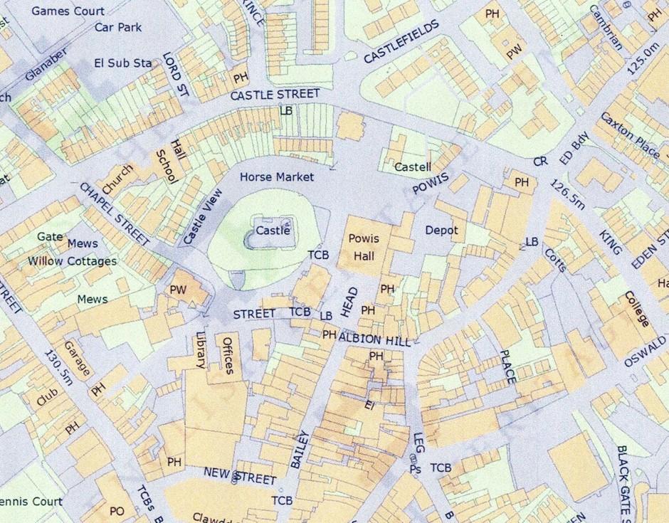
10 fig 1 Site location 10
11 fig 2 Trench location 11
12 12
13 13
ROUKEN GLEN: BANDSTAND 2015 DATA STRUCTURE REPORT
 ROUKEN GLEN: BANDSTAND 2015 DATA STRUCTURE REPORT Author (s) Ian Hill Editors Report Date June 2015 Working Partners Funders Phil Richardson East Renfrewshire Council East Renfrewshire Council, Heritage
Henderson Mess, RAF Halton, Buckinghamshire
 Henderson Mess, RAF Halton, Buckinghamshire An archaeological watching brief for Stepnell Ltd by Stephen Hammond Thames Valley Archaeological Services Ltd Site Code RHA03/85 October 2003 Summary Site name:
Archaeological Monitoring at Ham Farm, Ham Road, Faversham, Kent
 Archaeological Monitoring at Ham Farm, Ham Road, Faversham, Kent NGR: 601750.0mE 162695.0mN Site Code HAM/WB/12 Report for A.J. Bray SWAT ARCHAEOLOGY Swale and Thames Archaeological Survey Company The
Holyport Manor Special School, Highfield Lane, Cox Green, Maidenhead, Berkshire
 Holyport Manor Special School, Highfield Lane, Cox Green, Maidenhead, Berkshire An Archaeological recording action For CgMs Consulting by Jennifer Lowe Thames Valley Archaeological Services Ltd Site Code
Cholesbury New House, Parrots Lane, Cholesbury, Buckinghamshire
 Cholesbury New House, Parrots Lane, Cholesbury, Buckinghamshire An Archaeological Watching Brief For Mr Martin Wood by Sean Wallis Thames Valley Archaeological Services Ltd Site Code PLC 06/135 March 2007
THE HEUGH LINDISFARNE
 LINDISFARNE COMMUNITY ARCHAEOLOGY THE HEUGH LINDISFARNE Archaeological excavations in June 2017 Invitation to volunteers THE HEUGH, LINDISFARNE, NORTHUMBERLAND: ARCHAEOLOGICAL EXCAVATIONS 2017 INTRODUCTION
Wessex Archaeology. Little Stubbings, West Amesbury, Salisbury, Wiltshire. Archaeological Watching Brief. Ref:
 Wessex Archaeology Little Stubbings, West Amesbury, Salisbury, Wiltshire Ref: 63280.02 March 2007 LITTLE STUBBINGS, WEST AMESBURY, NR SALISBURY, WILTSHIRE ARCHAEOLOGICAL WATCHING BRIEF Prepared for: P
Unlocking Our Coastal Heritage Project: Crane Castle Promontory Fort, Illogan, Cornwall
 Unlocking Our Coastal Heritage Project: Crane Castle Promontory Fort, Illogan, Cornwall As part of a wider project funded by the Rural Development Programme for England (RDPE) and administered through
Archaeological Watching Brief at the Brick Stables and Wagon Lodge, Abbey Barns, Abbey Road, Faversham, Kent September 2010
 Archaeological Watching Brief at the Brick Stables and Wagon Lodge, Abbey Barns, Abbey Road, Faversham, Kent September 2010 SWAT. Archaeology Swale and Thames Archaeological Survey Company School Farm
Northamptonshire Archaeology
 Northamptonshire Archaeology A programme of archaeological observation, investigation and recording at St Andrews Church, Spratton, Northamptonshire Northamptonshire Archaeology 2 Bolton House Wootton
HILL-FORTS OF THE INNER TAY ESTUARY PERTH. Phase One PERTH AND KINROSS. Archaeological Survey Report. Oxford Archaeology North.
 HILL-FORTS OF THE INNER TAY ESTUARY PERTH PERTH AND KINROSS Phase One Archaeological Survey Report Oxford Archaeology North September 2012 Issue No: 2012-13/11322 OAN Job No: L10492a NGR: NO 182 153, NO
Archaeological Evaluation Report
 Holywell House Osney Mead Oxford o a November 2007 Client: Knowles and Son Issue N o : 1 OA Job N o : 3826 Planning Ref N o : 02/01800/FUL NGR: SP 502 055 Client Name: Knowles and Son Client Ref No: Document
The Coach House, Mill Lane, Cookham, Berkshire
 The Coach House, Mill Lane, Cookham, Berkshire An Archaeological Watching Brief For Ms Sophia Butler by Stephen Hammond Thames Valley Archaeological Services Ltd Site Code CMC 03/104 October 2003 Summary
The Old Shire Horse Centre, Bath Road, Woolley Green, Maidenhead, Berkshire
 The Old Shire Horse Centre, Bath Road, Woolley Green, Maidenhead, Berkshire An Archaeological Watching Brief For Mr Derek Chesterman by Andrew Mundin Thames Valley Archaeological Services Ltd Site Code
Archaeological Watching Brief on land at Alpha, Gore Road, Eastry, Kent July 2010
 Archaeological Watching Brief on land at Alpha, Gore Road, Eastry, Kent July 2010 SWAT. Archaeology Swale and Thames Archaeological Survey Company School Farm Oast, Graveney Road Faversham, Kent ME13 8UP
Land off Birdie Way, Rush Green, Hertford, Hertfordshire
 Land off Birdie Way, Rush Green, Hertford, Hertfordshire An Archaeological Evaluation for Bride Hall Development Limited by Sarah Coles Thames Valley Archaeological Services Site Code RGH00/ 01 January
Wheatlands House, Fleet Hill, Finchampstead, Berkshire
 Wheatlands House, Fleet Hill, Finchampstead, Berkshire An Archaeological Watching Brief For JCA International by James McNicoll-Norbury Thames Valley Archaeological Services Ltd Site Code WFF 08/26 August
o a London Borough of Barnet Stoney Wood Lake Silk Stream Flood Alleviation Scheme Archaeological Watching Brief Report Oxford Archaeology
 Silk Stream Flood Alleviation Scheme Stoney Wood Lake London Borough of Barnet Archaeological Watching Brief Report o a Oxford Archaeology November 2004 Client: Halcrow on behalf of Environment Agency
An archaeological watching brief on land adjacent to 50 Rosebery Avenue, Colchester, Essex May/June 2003
 An archaeological watching brief on land adjacent to 50 Rosebery Avenue, Colchester, Essex May/June 2003 report prepared by C Crossan on behalf of Highfield Homes Ltd NGR: TM 0035 2500 CAT project ref.:
ARCHAEOLOGICAL S E R V I C E S. Phase 5, Grimsby Road, Cippenham, Slough, Berkshire. Archaeological Recording Action.
 T H A M E S V A L L E Y ARCHAEOLOGICAL S E R V I C E S Phase 5, Grimsby Road, Cippenham, Slough, Berkshire Archaeological Recording Action by Andy Taylor Site Code: GRC13/57 (SU 9493 7977) Phase 5, Eltham
A21 TONBRIDGE TO PEMBURY DUALLING. Statement of Case
 A21 TONBRIDGE TO PEMBURY DUALLING Statement of Case In Respect of Applications for the Demolition of Listed Buildings Under the Provisions of the Planning (Listed Buildings and Conservation Areas) Act
Deddington Castle, Oxfordshire: A Summary of Excavations *
 Deddington Castle, Oxfordshire: A Summary of Excavations 1977 1979* R.J. Ivens for Queen s University, Belfast, and DoE Between 1947 and 1951 Prof. E.M. Jope carried out a series of rescue excavations
Following the initial soil strip archaeology is sprayed up prior to planning and excavation
 Barton Quarry & Archaeology Over the past half century quarries have been increasingly highlighted as important sources of information for geologists, palaeontologists and archaeologists, both through
East Midlands Region LEICESTER 3/16 (E.62.A010) SK
 SK") LEICESTER City of Leicester 3/16 (E.62.A010) SK 5853 0433 12 NEW ST., CASTLE WARD, LEICESTER Cottage to the Rear of 12 New St., Castle Ward, Leicester - A Photographic Survey and Archaeological Watching
LEICESTER City of Leicester 3/16 (E.62.A010) SK 5853 0433 12 NEW ST., CASTLE WARD, LEICESTER Cottage to the Rear of 12 New St., Castle Ward, Leicester - A Photographic Survey and Archaeological Watching
Revision: Date: Prepared by: Checked by: Approved by: Reason for Issue: Nick Elsden (MOLA) Nick Elsden (MOLA) Page 2
 Nick Elsden (MOLA) Page 2") This document contains proprietary information. No part of this document may be reproduced without prior written consent from the chief executive of Crossrail Ltd. Revision: Date: Prepared by: Checked
This document contains proprietary information. No part of this document may be reproduced without prior written consent from the chief executive of Crossrail Ltd. Revision: Date: Prepared by: Checked
S E R V I C E S. Land to the rear of Ashdown, Basingstoke Road, Spencers Wood, Reading, Berkshire. Archaeological Evaluation.
 T H A M E S V A L L E Y ARCHAEOLOGICAL S E R V I C E S Land to the rear of Ashdown, Basingstoke Road, Spencers Wood, Reading, Berkshire Archaeological Evaluation by Susan Porter Site Code: ASW12/21 (SU
Archaeological Investigations Project South East Region SOUTHAMPTON 2/842 (C.80.C004) SU
 SU") SOUTHAMPTON City of Southampton 2/842 (C.80.C004) SU 4382 1336 125 BITTERNE ROAD WEST, SOUTHAMPTON Report on the Archaeological Evaluation Excavation at 125 Bitterne Road West, Southampton Russel, A. D
SOUTHAMPTON City of Southampton 2/842 (C.80.C004) SU 4382 1336 125 BITTERNE ROAD WEST, SOUTHAMPTON Report on the Archaeological Evaluation Excavation at 125 Bitterne Road West, Southampton Russel, A. D
Report on an archaeological watching brief at Thomas Lord Audley School, Monkwick, Colchester
 Report on an archaeological watching brief at Thomas Lord Audley School, Monkwick, Colchester July 2000 for WS Atkins Property Services Colchester Archaeological Trust 12 Lexden Road, Colchester, Essex
Gorse Stacks, Bus Interchange Excavations Interim Note-01
 Gorse Stacks, Bus Interchange Excavations 2015 Prepared for: Cheshire West & Chester Council Interim Note-01 1 Introduction & Summary Background Since c. 2000 investigations associated with redevelopment
Perth and Kinross Council Development Control Committee 12 December 2012 Report of Handling by Development Quality Manager
 Perth and Kinross Council Development Control Committee 12 December 2012 Report of Handling by Development Quality Manager 4(3)(i) 12/570 Alterations and replacement windows at Milnathort Town Hall, 1
An archaeological excavation at 193 High Street, Kelvedon, Essex September 2009
 An archaeological excavation at 193 High Street, Kelvedon, Essex September 2009 report prepared by Ben Holloway and Howard Brooks on behalf of Marden Homes CAT project ref.: 09/4g NGR: TL 8631 1913 (c)
An archaeological evaluation at 14 Vineyard Street, Colchester, Essex March 2006
 An archaeological evaluation at 14 Vineyard Street, Colchester, Essex March 2006 report prepared by Ben Holloway commissioned by Colchester Borough Council CAT project code: 06/4b Colchester Museums accession
An archaeological watching brief at 97 High Street, Colchester, Essex March 2010
 An archaeological watching brief at 97 High Street, Colchester, Essex March 2010 report prepared by Donald Shimmin on behalf of Flying Trade Group plc CAT project ref.: 10/3a Colchester and Ipswich Museums
REPORT NUMBER 001 ARCHAEOLOGICAL DOWSING SURVEY BISHOPS SUTTON NEAR ALRESFORD HAMPSHIRE. D P BRYAN BA (Hons) MARCH 2012
 MARCH 2012") REPORT NUMBER 001 ARCHAEOLOGICAL DOWSING SURVEY AT BISHOPS SUTTON NEAR ALRESFORD HAMPSHIRE D P BRYAN BA (Hons) MARCH 2012 1 Table of Contents 1. Introduction 1.1 Project Background Page 2 1.2 Site Location
REPORT NUMBER 001 ARCHAEOLOGICAL DOWSING SURVEY AT BISHOPS SUTTON NEAR ALRESFORD HAMPSHIRE D P BRYAN BA (Hons) MARCH 2012 1 Table of Contents 1. Introduction 1.1 Project Background Page 2 1.2 Site Location
Aylesbury Masonic Hall, Ripon Street, Aylesbury, Buckinghamshire
 Aylesbury Masonic Hall, Ripon Street, Aylesbury, Buckinghamshire An Archaeological Recording Action for Wakefield Building Services by Andrew Mundin Thames Valley Archaeological Services Ltd Site Code
Excavations in a Medieval Market Town: Mountsorrel, Leicestershire,
 Excavations in a Medieval Market Town: Mountsorrel, Leicestershire, by John Lucas Mountsorrel is situated 12 kms north of Leicester and forms a linear settlement straddling the A6, Leicester to Derby road.
PSP 75 Lancefield Road. Northern Jacksons Creek Crossing Supplementary Information
 PSP 75 Lancefield Road Northern Jacksons Creek Crossing Supplementary Information September 2017 The northern crossing of Jacksons Creek proposed within the Lancefield Road PSP is a key part of the ultimate
Perth and Kinross Council Development Control Committee 27 August 2008 Recommendation by Development Quality Manager
 Perth and Kinross Council Development Control Committee 27 August 2008 Recommendation by Development Quality Manager 5(7) 08/414 Erection of kennels and cattery at Baltree Farm, Hatchbank, Kinross, KY13
Documentation of Mosaic Tangible Heritage in Jordan Jarash Governorate
 Documentation of Mosaic Tangible Heritage in Jordan Jarash Governorate Catreena Hamarneh, Abdel Majeed Mjalli, Mohamed al-balawneh Introduction In the year 2005 a project was launched to build up a data
Schedule of Planning Applications Committee Date: 23 May Reference: 06/18/0064/F Great Yarmouth Officer: Mr J Beck Expiry Date:
 Schedule of Planning Applications Committee Date: 23 May 2018 Reference: 06/18/0064/F Great Yarmouth Officer: Mr J Beck Expiry Date: 24-04-2018 Applicant: Proposal: Site: Mr Mavroudis Clear weather hoardings
COMMISSION IMPLEMENTING REGULATION (EU)
") 18.10.2011 Official Journal of the European Union L 271/15 COMMISSION IMPLEMENTING REGULATION (EU) No 1034/2011 of 17 October 2011 on safety oversight in air traffic management and air navigation services
18.10.2011 Official Journal of the European Union L 271/15 COMMISSION IMPLEMENTING REGULATION (EU) No 1034/2011 of 17 October 2011 on safety oversight in air traffic management and air navigation services
BRONZE AGE FIELD SYSTEM AT SOUTHAMPTON AIRPORT
 Proc. Hampshire Field Club Archaeol. Soc. 65, 2010, 1-6 (Hampshire Studies 2010) BRONZE AGE FIELD SYSTEM AT SOUTHAMPTON AIRPORT By J SULIKOWSKA With contributions by LORRAINE MEPHAM and CHRIS J STEVENS
Minimal Impact Caving Guidelines
 Minimal Impact Caving Guidelines Photograph Brendan Marris 2016 Introduction Caving is a fascinating recreational activity which attracts the interest of a diverse range of people and groups, who all benefit
Archaeological Investigations Project Yorkshire & Humberside Region NORTH YORKSHIRE 2/1113 (C.36.J002) SD
 SD") NORTH YORKSHIRE Craven 2/1113 (C.36.J002) SD 93607800 CRAY BECK, BUCKDEN, UPPER WHARFEDALE Cray Beck, The Archaeological Investigation of a Stone Feature Archetype Wensleydale : ArcheType Archaeological
NORTH YORKSHIRE Craven 2/1113 (C.36.J002) SD 93607800 CRAY BECK, BUCKDEN, UPPER WHARFEDALE Cray Beck, The Archaeological Investigation of a Stone Feature Archetype Wensleydale : ArcheType Archaeological
Lancaster Castle THE CASTLE STUDIES GROUP JOURNAL NO 26:
 Lancaster Castle. The Henry IV gatehouse from the south-east. The C15 gatehouse subsumes a C12/13 stone gateway, observable inside the gate passage beyond the portcullis. The lower level loops originally
Remote Sensing into the Study of Ancient Beiting City in North-Western China
 Dingwall, L., S. Exon, V. Gaffney, S. Laflin and M. van Leusen (eds.) 1999. Archaeology in the Age of the Internet. CAA97. Computer Applications and Quantitative Methods in Archaeology. Proceedings of
Archaeological Observation at The Bishop s Palace, Alvechurch, Worcestershire
 Warwickshire County Council THE MOAT HOUSE Archaeological Observation at The Bishop s Palace, Alvechurch, Worcestershire Chris Jones and Bryn Gethin Report 1059 December 2010 The Moat House: Archaeological
Jane C. Waldbaum Archaeological Field School Scholarship - Report.
 Jane C. Waldbaum Archaeological Field School Scholarship - Report. Eastern Boeotia Archaeological Project, 2017 Novella Nicchitta Figure 1 EBAP's team for 2017 This year I had the pleasure of participating
COMMISSION OF THE EUROPEAN COMMUNITIES. Draft. COMMISSION REGULATION (EU) No /2010
 No /2010") COMMISSION OF THE EUROPEAN COMMUNITIES Brussels, XXX Draft COMMISSION REGULATION (EU) No /2010 of [ ] on safety oversight in air traffic management and air navigation services (Text with EEA relevance)
COMMISSION OF THE EUROPEAN COMMUNITIES Brussels, XXX Draft COMMISSION REGULATION (EU) No /2010 of [ ] on safety oversight in air traffic management and air navigation services (Text with EEA relevance)
An archaeological watching brief on a new cable trench at the Abbey Field sports pitches, Circular Road North, Colchester, Essex October 2006
 An archaeological watching brief on a new cable trench at the Abbey Field sports pitches, Circular Road North, Colchester, Essex report prepared by Ben Holloway on behalf of Atkins Defence CAT project
MANAGING THE RISK TO AVIATION SAFETY OF WIND TURBINE INSTALLATIONS (WIND FARMS)/WIND MONITORING TOWERS.
/WIND MONITORING TOWERS.") NATIONAL AIRPORTS SAFEGUARDING FRAMEWORK GUIDELINE D MANAGING THE RISK TO AVIATION SAFETY OF WIND TURBINE INSTALLATIONS (WIND FARMS)/WIND MONITORING TOWERS. REVISION DATE VERSION NUMBER CHANGES MADE APPROVED
NATIONAL AIRPORTS SAFEGUARDING FRAMEWORK GUIDELINE D MANAGING THE RISK TO AVIATION SAFETY OF WIND TURBINE INSTALLATIONS (WIND FARMS)/WIND MONITORING TOWERS. REVISION DATE VERSION NUMBER CHANGES MADE APPROVED
Doncaster Market Place Conservation Area
 Doncaster Market Place Conservation Area Review December 2014 www.doncaster.gov.uk/conservationareas Doncaster Market Place Conservation Area Review Since the appraisal undertaken in March 2007, the general
Pen-y-gaer Roman Vicus, Cwmdu, Powys: Draft Interim Report
 CPAT Report No 1107 Pen-y-gaer Roman Vicus, Cwmdu, Powys: ARCHAEOLOGICAL EXCAVATION THE CLWYD-POWYS ARCHAEOLOGICAL TRUST CPAT Report No 1107 Pen-y-gaer Roman Vicus, Cwmdu, Powys: ARCHAEOLOGICAL EXCAVATION
CASTLE OF OLD WICK HISTORIC ENVIRONMENT SCOTLAND STATEMENT OF SIGNIFICANCE. Property in Care(PIC) ID: PIC282 Designations:
 ID: PIC282 Designations:") Property in Care(PIC) ID: PIC282 Designations: Scheduled Monument (SM90065) Taken into State care: 1957 (Guardianship) Last reviewed: 2004 HISTORIC ENVIRONMENT SCOTLAND STATEMENT OF SIGNIFICANCE CASTLE
Property in Care(PIC) ID: PIC282 Designations: Scheduled Monument (SM90065) Taken into State care: 1957 (Guardianship) Last reviewed: 2004 HISTORIC ENVIRONMENT SCOTLAND STATEMENT OF SIGNIFICANCE CASTLE
Foreign Air Carrier Family Support Act. August, 2011
 Foreign Air Carrier Family Support Act August, 2011 Principles of Family Assistance Deutsche Lufthansa AG d/b/a Lufthansa German Airlines and Lufthansa Cargo AG (hereinafter referred to collectively as
Energy from Waste and Recycling Facility Trident Park, Cardiff. Planning History. January 2010 SLR Ref: B
 Energy from Waste and Recycling Facility Trident Park, Cardiff Planning History January 2010 Ref: 402-0036-0306B Viridor Ltd. i 402/0036/00306B CONTENTS 1.0 INTRODUCTION... 1 2.0 GENERAL HISTORY... 3
Stobs Camp Project Quarter 1 Report April June 2018
 Stobs Camp Project Quarter 1 Report April June 2018 Executive Summary During this period the project ran an excavation at two fortification practice trenches. Adult volunteers and school pupils were able
FOUNDATIONS OF ARCHAEOLOGY A WALK IN VERNDITCH CHASE
 FOUNDATIONS OF ARCHAEOLOGY A WALK IN VERNDITCH CHASE 1. A Tale of two Long Barrows Long barrows were constructed as earthen or drystone mounds with flanking ditches and acted as funerary monuments during
International Civil Aviation Organization REVIEW OF STATE CONTINGENCY PLANNING REQUIREMENTS. (Presented by the Secretariat) SUMMARY
 SUMMARY") BBACG/16 WP/4 31/01/05 International Civil Aviation Organization The Special Coordination Meeting for the Bay of Bengal area (SCM/BOB) and The Sixteenth Meeting of the Bay of Bengal ATS Coordination Group
BBACG/16 WP/4 31/01/05 International Civil Aviation Organization The Special Coordination Meeting for the Bay of Bengal area (SCM/BOB) and The Sixteenth Meeting of the Bay of Bengal ATS Coordination Group
An archaeological watching brief at the Sixth Form College, North Hill, Colchester, Essex
 An archaeological watching brief at the Sixth Form College, North Hill, Colchester, Essex July 2001 on behalf of Colchester Borough Council CAT project ref.: 01/7B Colchester Museum accession code: 2001.126
Archaeological monitoring and recording at DSG (Defence Support Group), Flagstaff Road, Colchester, Essex, CO2 7SR
, Flagstaff Road, Colchester, Essex, CO2 7SR") Archaeological monitoring and recording at DSG (Defence Support Group), Flagstaff Road, Colchester, Essex, CO2 7SR October 2017 by Laura Pooley figures by Laura Pooley and Sarah Carter fieldwork by Nigel
Archaeological monitoring and recording at DSG (Defence Support Group), Flagstaff Road, Colchester, Essex, CO2 7SR October 2017 by Laura Pooley figures by Laura Pooley and Sarah Carter fieldwork by Nigel
Certification Memorandum. Large Aeroplane Evacuation Certification Specifications Cabin Crew Members Assumed to be On Board
 Certification Memorandum Large Aeroplane Evacuation Certification Specifications Cabin Crew Members Assumed to be On Board EASA CM No.: CM CS-008 Issue 01 issued 03 July 2017 Regulatory requirement(s):
Trench 91 revealed that the cobbled court extends further to the north.
 Report on the 2013 Gournia Excavations The 2013 excavations at Gournia were conducted June 17 July 26 under the aegis of the American School of Classical Studies at Athens and the supervision of the KD
Long Cairn Divis County Antrim
 Survey Report No. 66 Harry Welsh Long Cairn Divis County Antrim 2 Ulster Archaeological Society 2018 Ulster Archaeological Society c/o School of Natural and Built Environment Queen s University Belfast
archaeological evaluation of sites to the west of the castle in 1988
 FLNT CASTLE archaeological evaluation of sites to the west of the castle in 1988 -.., - w -... " - Clwyd-Powys Archaeological Trust '.. - Flint Castle, Delyn: evaluation of sites west of the castle in
Local Development Scheme
 Local Development Scheme August 2014 Local Development Scheme (August 2014) / Page 2 Contents Section 1: Introduction Great Yarmouth s Development Plan 4 Section 2: Plan Making Process Public participation
Terms of Reference: Introduction
 Terms of Reference: Assessment of airport-airline engagement on the appropriate scope, design and cost of new runway capacity; and Support in analysing technical responses to the Government s draft NPS
Perth and Kinross Council Development Management Committee 27 March 2013 Report of Handling by Development Quality Manager
 Perth and Kinross Council Development Management Committee 27 March 2013 Report of Handling by Development Quality Manager 4(3)(ii) 13/138 Erection of a Structure for Floral Display in the Public Park,
Carisbrooke. Fig. 1. Carisbrooke Castle shell-keep, c with added gatehouse and portcullis c
 Fig. 1. Carisbrooke Castle shell-keep, c. 1130-40 with added gatehouse and portcullis c. 1335. 4. Carisbrooke The castle s founder, William fitzosbern, built an enclosure castle soon after the Norman Conquest.
Island Bay Foreshore: Archaeological Issues
 Island Bay Foreshore: Archaeological Issues arczoo Ltd, PO Box 14 575, WELLINGTON ph 04 388 5338 email aczoo@paradise.net.nz Prepared for Wellington City Council February 2005 1 Introduction Wellington
AIRPORT VOLUNTARY COMMITMENT ON AIR PASSENGER SERVICE
 AIRPORT VOLUNTARY COMMITMENT ON AIR PASSENGER SERVICE PREAMBLE European airports have developed an Airport Voluntary Commitment on Air Passenger Service following extensive consultation with representatives
N18 Ennis Bypass and N85 Western Relief Road. Site AR125, Clareabbey, Co. Clare
 N18 Ennis Bypass and N85 Western Relief Road Site AR125, Clareabbey, Co. Clare Final Archaeological Excavation Report for Clare County Council Licence No: 04E0023 by Graham Hull Job J04/02 (NGR 134366
Looking north from the SW shieling site with Lub na Luachrach in the foreground
 Looking north from the SW shieling site with Lub na Luachrach in the foreground Upper Gleann Goibhre - Shieling sites Two shieling sites in the upper reaches of the Allt Goibhre were visited and recorded
Chiselbury Camp hillfort
 Chiselbury Camp hillfort Reasons for Designation Large univallate hillforts are defined as fortified enclosures of varying shape, ranging in size between 1ha and 10ha, located on hilltops and surrounded
Contents. Crossrail Limited RESTRICTED. Summary of LSS85 archive Broadgate Excavations C257-MLA-T1-XTC-C101_WS
 Summary of LSS85 archive Broadgate Excavations Contents 1 Purpose...4 2 Scope...4 3 Definitions...4 4 LSS85 Archive Summary Report...4 5 Summary Data - Burials found in Liverpool Street...5 6 Note from
Non-technical summary
 Introduction NTS1 NTS2 NTS3 Troika Developments Ltd (Troika) has submitted a planning application to Bournemouth Borough Council (BBC) for an extension of time to implement planning permission 7/2004/16450/G,
Arrangements for the delivery of minor highway maintenance services by Town and Parish Councils
 Arrangements for the delivery of minor highway maintenance services by Town and Parish Councils Cabinet Date of Meeting 8 March 2017 Officer Cllr Peter Finney, Cabinet Member for Environment, Infrastructure
Appendix - Restormel
 Fig. 1. Restormel castle, from the west. Stonework substantially late 13 th & early 14 th century. Appendix - Restormel 21. Restormel The site was acquired by Richard, earl of Cornwall (d. 1272) and was
E&M West Buildings Union Street, Aberdeen, AB10 1GD
 E&M West Buildings 32-38 Union Street, Aberdeen, AB10 1GD 30 November 2011 E&M West Buildings 32-38 Union Street, Aberdeen, AB10 1GD CONTENTS 1 INTRODUCTION 3 2 ARCHAEOLOGICAL BACKGROUND 4 3 THE WATCHING
SUMMER VILLAGE OF SILVER SANDS. Municipal Development Plan
 SUMMER VILLAGE OF SILVER SANDS Municipal Development Plan Bylaw 253-2014 Adopted August 22, 2014 Summer Village of Silver Sands Municipal Development Plan Bylaw No. 253-2014 Page 2 1 INTRODUCTION 1.1 SETTING
Research Briefing Flood and Coastal Erosion Risk Management in Wales
 Research Briefing Flood and Coastal Erosion Risk Management in Wales Author: Wendy Dodds Date: September 2017 National Assembly for Wales Research Service The National Assembly for Wales is the democratically
Air Operator Certification
 Civil Aviation Rules Part 119, Amendment 15 Docket 8/CAR/1 Contents Rule objective... 4 Extent of consultation Safety Management project... 4 Summary of submissions... 5 Extent of consultation Maintenance
Please see our website for up to date contact information, and further advice.
 Saxon Shore Forts On 1st April 2015 the Historic Buildings and Monuments Commission for England changed its common name from English Heritage to Historic England. We are now re-branding all our documents.
IMTO Italian Mission to Oman University of Pisa 2011B PRELIMINARY REPORT (OCTOBER-DECEMBER 2011)
") IMTO Italian Mission to Oman University of Pisa 2011B PRELIMINARY REPORT (OCTOBER-DECEMBER 2011) The 2011B research campaign took place in the area around Salut from October, 19 th, to December, 16 th.
IMTO Italian Mission to Oman University of Pisa 2011B PRELIMINARY REPORT (OCTOBER-DECEMBER 2011) The 2011B research campaign took place in the area around Salut from October, 19 th, to December, 16 th.
Part 141. Aviation Training Organisations Certification. CAA Consolidation. 10 March Published by the Civil Aviation Authority of New Zealand
 Part 141 CAA Consolidation 10 March 2017 Aviation Training Organisations Certification Published by the Civil Aviation Authority of New Zealand DESCRIPTION Part 141 prescribes rules governing the certification
ICAO SUMMARY REPORT AUDIT OF THE DEPARTMENT OF CIVIL AVIATION OF THE LAO PEOPLE S DEMOCRATIC REPUBLIC
 ICAO Universal Safety Oversight Audit Programme ICAO SUMMARY REPORT AUDIT OF THE DEPARTMENT OF CIVIL AVIATION OF THE LAO PEOPLE S DEMOCRATIC REPUBLIC (Vientiane, 22 to 30 April 1999) INTERNATIONAL CIVIL
NATIONAL AIRSPACE POLICY OF NEW ZEALAND
 NATIONAL AIRSPACE POLICY OF NEW ZEALAND APRIL 2012 FOREWORD TO NATIONAL AIRSPACE POLICY STATEMENT When the government issued Connecting New Zealand, its policy direction for transport in August 2011, one
Date: 11 th January, From: Plaistow & Ifold Parish Neighbourhood Plan - Steering Group. Plaistow & Ifold Parish Council
 Date: 11 th January, 2017 From: Plaistow & Ifold Parish Neighbourhood Plan - Steering Group To: Plaistow & Ifold Parish Council Re: Neighbourhood Plan Report to Parish Council Meeting 17 Jan 2017 The Steering
Beech House, F ordham Road, Exning, Suffolk
 Beech House, F ordham Road, Exning, Suffolk An Archaeological Monitoring of Works. Dave Webb CAMBRIDGE ARCHAEOLOGICAL UNIT UNIVERSITY OF CAMBRIDGE Archaeological Monitoring of works at Beech House, Fordham
Wales. Cymru. Our Language Policy. Ein Polisi Iaith
 Wales Cymru Our Language Policy Ein Polisi Iaith 1 INTRODUCTION NatWest is a member of The Royal Bank of Scotland Group (RBS), one of the world s largest banking and financial institutions. The RBS Group
The Strategic Commercial and Procurement Manager
 Item 3 To: Procurement Sub Committee On: 8 June 2016 Report by: The Strategic Commercial and Procurement Manager Heading: Renfrewshire Council s Community Benefit Strategy 2016 1. Summary 1.1. The purpose
Scheduled Monument (SM90085) Taken into State care: 1966 (Guardianship) Last reviewed: 2004 CROOKSTON CASTLE
 Taken into State care: 1966 (Guardianship) Last reviewed: 2004 CROOKSTON CASTLE") Property in Care (PIC) ID: PIC119 Designations: Scheduled Monument (SM90085) Taken into State care: 1966 (Guardianship) Last reviewed: 2004 HISTORIC ENVIRONMENT SCOTLAND STATEMENT OF SIGNIFICANCE CROOKSTON
Property in Care (PIC) ID: PIC119 Designations: Scheduled Monument (SM90085) Taken into State care: 1966 (Guardianship) Last reviewed: 2004 HISTORIC ENVIRONMENT SCOTLAND STATEMENT OF SIGNIFICANCE CROOKSTON
Erica Kinias Brown University, Department of the History of Art and Architecture
 Erica Kinias Brown University, Department of the History of Art and Architecture Archaeological Institute of America Jane C. Waldbaum Scholarship Fund Research Outcomes With the generous support from the
Skellig Michael Action Plan Appendix 2 Position as of January Objective: Action: Complete: In Progress: Not yet Commenced
 Objective 1: To put in place an effective management framework to protect the Outstanding Universal Value of Skellig Michael Action 1. Appointment of a Site Management team Action 2. Provision of adequate
158 HUT POINT, ROSS ISLAND
 Measure 13 (2015) Management Plan For Antarctic Specially Protected Area No. 158 HUT POINT, ROSS ISLAND (including Historic Site and Monument No. 18, the historic Discovery hut of Captain Robert Falcon
Survey of Deadwater Fell and Peel Fell
 4 December 2014 Survey of Deadwater Fell and Peel Fell Team: John Barnard, Chris Crocker, Richard Cooper and Graham Jackson 1) Introduction Deadwater Fell (Hill 3542, Section 33, OS 1:50000 Map 80, OS
HUT POINT, ROSS ISLAND
 Measure 2 (2005) Annex K Management Plan for Antarctic Specially Protected Area No. 158 HUT POINT, ROSS ISLAND (including Historic Site and Monument No. 18, the historic Discovery hut of Captain R F Scott)
Architectural Analysis in Western Palenque
 Architectural Analysis in Western Palenque James Eckhardt and Heather Hurst During the 1999 season of the Palenque Mapping Project the team mapped the western portion of the site of Palenque. This paper
Afon Adda Refurbishment Bangor
 Afon Adda Refurbishment Bangor Archaeological Assessment Revised Report GAT Project No. 1876 Report No. 628 April 2006 Ymddiriedolaeth Archaeolegol Gwynedd Gwynedd Archaeological Trust Craig Beuno, Ffordd
Update on implementation of Taking Revalidation Forward recommendations
 Agenda item: 7 Report title: Report by: Action: Update on implementation of Taking Revalidation Forward recommendations Judith Chrystie, Assistant Director, Registration and Revalidation Judith.Chrystie@gmc-uk.org,