Newbold Hall, Rochdale. An Archaeological Excavation
|
|
|
- Baldwin Rogers
- 5 years ago
- Views:
Transcription


1 School of the Built Environment CUBE Building, University of Salford Portland Street Manchester M1 6DW Tel: Web: Newbold Hall, Rochdale. An Archaeological Excavation A Report by Vicky Nash, Dr Michael Nevell & Adam Thompson CfAA Report No: 8/2010 Centre for Applied Archaeology CUBE University of Salford Portland Street Manchester M1 6DW Tel: m.d.nevelle@salford.ac.uk Web: CfAA. Hill Farm Barn, Staffordshire, Historic Building Survey, May
2 Contents Summary 3 1. Introduction 4 2. Historical Background 6 3. Methodology 8 4. Archaeological Description Archaeological Results Archaeological Conclusions Sources Archive Acknowledgments Appendix 1: Context List Appendix 2: Figures Appendix 3: Photographic Archive 49 CfAA 2010/8 An Archaeological Excavation at the site of Newbold Hall, Rochdale, Greater Manchester. Page 2
3 Summary The Centre for Applied Archaeology (CfAA), were commissioned by Mr Patrick Bride to undertake an archaeological excavation at the site of Newbold Hall, Rochdale, Greater Manchester centred on NGR SD The works exposed and recorded all surviving archaeological remains within the proposed development area and a number of selective intrusive test trenches were excavated across the site identifying that a substantial part of the hall s external and internal footprint had survived below the present ground surface. As a result the CfAA can conclude that there were substantial surviving remains of Newbold Hall s northern and central wings and front, cobbled, courtyard that can be classed as significant. The remains revealed a multi-period site, the earliest element of which appeared to be an early 17 th century, stone-built, freehold hall which fitted the pattern of manorial and freehold hall development within the region during the 17 th century. This report recommends that the project of archaeological works completed to date are sufficient to comply with all archaeological requirements as discussed with Dr Andrew Myers, Assistant County Archaeologist for the Greater Manchester Archaeological Unit (GMAU). CfAA 2010/8 An Archaeological Excavation at the site of Newbold Hall, Rochdale, Greater Manchester. Page 3
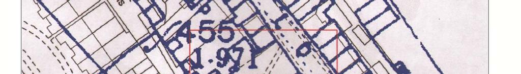
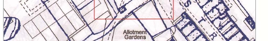
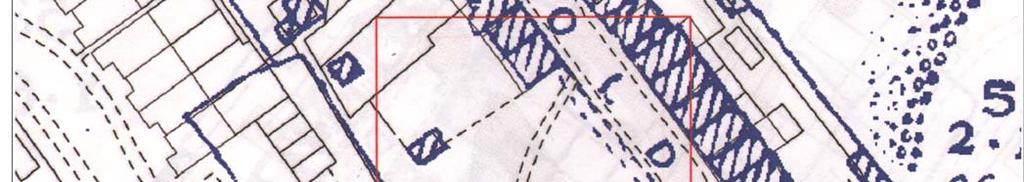
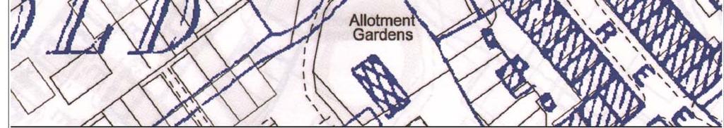
4 1. Introduction 1.1 Introduction The Centre for Applied Archaeology (CfAA) were commissioned by Mr Patrick Bride to undertake an archaeological excavation of the land adjacent to 39 Newbold Street, Rochdale, OL16 5AH, which is proposed for redevelopment (NBH10 Fig 1). This work conformed to directions provided by Dr Andrew Myers, Assistant County Archaeologist for Greater Manchester Archaeological Unit (GMAU) and was informed by an archaeological Desk- Based Assessment of the site undertaken by Archaeological Research Services Ltd in October 2009 (Amat, ARS Ltd 2009) and an archaeological evaluation undertaken by Archaeological Research Services Ltd in November 2009 (Sheppy, ARS Ltd 2009). 1.2 Location & Topography Newbold Hall was centred at SD and lay 2.7 kilometres west of the M6, and 12 kilometres north-east of Manchester. The site sits at a height of c.141m AOD, which rises to approximately c.148m AOD to the north and south. Prior to excavation the site was generally flat with a slight incline dropping towards the east. The site was bounded to the north by No. 39 Newbold Street, to the east by Newbold Street, to the south by a footpath and allotment gardens, and to the west by Newbold Hall Drive housing development. The site consisted of a flat area of scrub which had a slight incline towards the east. The overburden had been removed by the client prior to commencement of the archaeological works and patches of rubble and stonework were visible through the scrub indicating the location of the surviving walls of Newbold Hall. 1.3 Geology The solid geology of the site comprised shales, mudstones and thin coals of the Upper Carboniferous Coal Measures that overlie the Upper Carboniferous sandstones and shales of the Millstone Grit ( 1.4 Personnel The project was conducted by professional archaeologists from the Centre of Applied Archaeology (CfAA). On-site excavations were conducted by Adam Thompson, Brian Grimsditch, Sarah Cattell and Vicky Nash. This report was written and compiled by Vicky Nash with contributions from Dr Michael Nevell and illustrated and managed by Adam Thompson. CfAA 2010/8 An Archaeological Excavation at the site of Newbold Hall, Rochdale, Greater Manchester. Page 4
5 1.5 Monitoring The archaeological requirement for the scheme of works was produced by Dr Andrew Myers, Assistant County Archaeologist for Greater Manchester (Greater Manchester Archaeology Unit, GMAU), who also monitored the programme of archaeological works.. CfAA 2010/8 An Archaeological Excavation at the site of Newbold Hall, Rochdale, Greater Manchester. Page 5
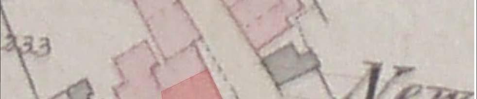
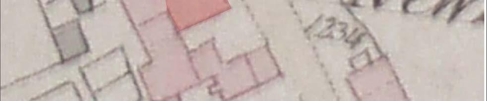
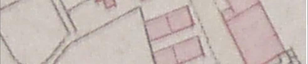
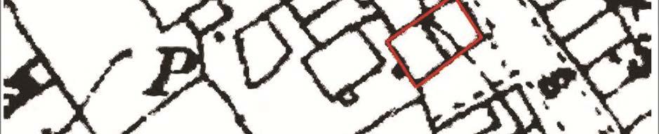
6 2. Historical Background 2.1 Medieval and Post Medieval Very little information with regard to the origins and development of Newbold Hall and its surrounding area were gathered by the Desk-Based Assessment of the site (Amat, ARS Ltd 2009). The earliest mention of Newbold in Rochdale appears in the form of a grant, recorded in the Coucher Book of Whalley ( ). This record states that Margerie, the daughter of William de Newbold, granted lands in Wardleworth to the Church of Rachdale (Amat 2009; Fishwick 1889, 40). On the 2 nd July 1620 it is recorded that an Edward Newbold died in Newbold, Rochdale, and at this time the Newbold estate was held by Sir John Byron in free socage by fealty and the yearly rent was 4d (Amat 2009). In 1627 Newbold Hall itself is first attested and is reportedly owned by a Richard Schofield, who later sold the hall to Thomas Hindley in 1707 (Amat 2009). Although no documentary evidence relating to Newbold Hall could be found prior to 1627, it is possible that a building was present on the site, prior to this date. In 1777 the Newbold estate was passed by Thomas Stead of Rochdale to James Holland, who then sold the hall in the early 1800 s to Joseph Newbold. It is then reported that the hall passed to Joseph s son, also named Joseph, but no records could be found to suggest who owned the Hall thereafter (Amat 2009; Fishwick 1889). On the 1844 tithe map (NBH10 Fig 4), Newbold Hall is shown as a stone building of two storeys. It was a courtyard plan house, built around three sides of a quadrangle, set on high ground with its front facing towards the north-east (Amat 2009; Walker & Tindall 1985). In Fishwick s History of Rochdale, he states that Newbold Hall had undergone many alterations and that it is clearly the remains of a many Gabled House with small-paned mullioned windows (Amat 2009; Fishwick 1889, 41). Fishwick also states that the hall had a gateway leading into the courtyard, which had buildings on all three sides. The buildings to the left (south) of the gateway originally formed part of the all which had been later converted into cottages and the front part of the hall had been reduced in size due to the erection of modern houses, which had taken the place of those which anciently formed the other side of the square (Amat 2009; Fishwick 1889, 41). Farrer & Brownbill noted that the south wing of the Hall is almost detached from the central wing and this is highlighted in the 1 st edition OS map of 1854 (NBH10 Fig 5). This may be the result either of the southern wing being converted into cottages, or this wing being a later addition to the hall (Amat 2009; Farrer and Brownbill 1911). In the late 19 th century, the 1 st revision OS map of 1893 (NBH10 Fig 6) shows the hall as a multi-roofed building which again relates to Fishwick s description. The separate buildings shown on the 1 st edition OS map of 1854 are now joined to form a whole structure. During the Edwardian period the northern wing of the Hall was used as a public house, and whilst some of the hall s original features were retained most of this wing was completely rebuilt, (Amat 2009; Walker & Tindall 1985). The central and southern wings of the hall were reported to be in a poor state of repair at this time, with the hall being divided into CfAA 2010/8 An Archaeological Excavation at the site of Newbold Hall, Rochdale, Greater Manchester. Page 6
7 separate tenements (Amat 2009; Walker & Tindall 1985). By the 2 nd edition OS map of 1906 (Fig) the hall had been demolished. The structure was considered to be a fine example of the smaller type of hall, built in stone, in the area and a good contrast to the timber buildings of the county (Amat 2009; Walker & Tindall 1985). Archaeological Evaluation The archaeological evaluation of Newbold Hall in November 2009 was conducted by a series of three evaluation trenches evenly spaced across the development area. The trenches targeted all three wings of the hall and identified a number of features indicating that the proposed development area covered approximately 65% of the hall s original footprint (Sheppy 2009). The evaluation confirmed the findings of the Desk-Based Assessment and revealed that ground floor remains relating to Newbold Hall still existed from which an understanding of its layout and construction could be obtained (Sheppy 2009). It had been suggested by documentary evidence that the hall had a typical courtyard plan enclosed on three sides and that all three wings of the building had undergone some level of rebuild during the late 18 th century. The results of this evaluation confirmed that these documentary sources were correct (Sheppy 2009). CfAA 2010/8 An Archaeological Excavation at the site of Newbold Hall, Rochdale, Greater Manchester. Page 7
8 3. Methodology 3.1 Excavation Methodology The requirements outlined by Dr Andrew Myers of GMAU for the archaeological excavation of Newbold Hall suggested that the proposed development area (16m x 12m) should be machine stripped and the archaeology fully exposed and recorded, and selective intrusive excavations conducted. The six trenches were proposed to expose the archaeological remains surviving within the development area (NBH10 Fig 10). Trench 1 was located within the exposed cobbled courtyard at the eastern end of the site. Trenches 2, 3 and 6 were positioned at the northern end, southern end and centre of the hall s central wing and were all aligned north-east/southwest. Trenches 4 and 5 were located along the northern and western edges of the site. Due to the large amount of exposed stonework on the site all the trenches had the potential for the survival of features or deposits associated with Newbold Hall. The site was stripped of its topsoil and subsoil by a mechanical excavator using a two-foot wide ditching bucket and all trenches were excavated by hand. Excavated spoil was placed at least 1.0m from the edge of the trenches and spoiled on the northern, southern and western edges of the site. Herras fencing was supplied by the land owner and was located along the southern, eastern and western extents of the area containing the trenches and abutted the surrounding garden wall of No. 39 Newbold Street to the north. Any archaeological features identified on site were hand excavated to their complete depth and recorded using the following methodology. 3.2 Recording Methodology Separate contexts were recorded individually on (CfAA) pro-forma context sheets (Appendix 1 Context List). Plans and sections were recorded on CfAA pro-forma drawing sheets at an appropriate scale of 1:10, 1:20, or 1:50, depending on the complexity of the data and features encountered. All drawings were individually identified and cross referenced, contexts enumerated and principal layers and features annotated with OD level information. Photography of all relevant phases and features was undertaken with digital formats. General working photographs were taken during the excavation to provide illustrative material covering the wider aspects of the archaeological work undertaken (Appendix 3 Photograpic Archive). All finds were recorded by context and significant small finds located within three dimensions to the nearest 10mm and were bagged and labelled separately. As no finds of archaeological significance were identified, all identified finds were deposited within the backfill as agreed in consultation with the Assistant County Archaeologist. All CfAA 2010/8 An Archaeological Excavation at the site of Newbold Hall, Rochdale, Greater Manchester. Page 8
9 fieldwork and recording of archaeological features, deposits and artefacts was carried out to the standards set out in the Code of Practice of the Institute of Field Archaeologists. CfAA 2010/8 An Archaeological Excavation at the site of Newbold Hall, Rochdale, Greater Manchester. Page 9
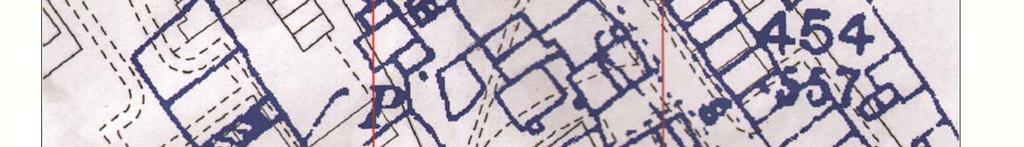
10 4.Archaeological Descriptions 4.1 North-East Quadrant The north-east quadrant of the site was bounded to the north by No. 39 Newbold Street and to the east by the current road which runs on an east-west alignment through Newbold Street. Prior to excavation the site had been machine stripped by the client which revealed a topsoil layer (001) of varying depth. This layer consisted of a dark blackish brown silty loam with frequent inclusions of brick fragments, sub-angular and rounded stones <0.10m. Located beneath (001) was a subsoil layer of varying depths (002), which consisted of a dark greyish brown silty loam with frequent inclusions of sub-angular stones <0.07m. All identified archaeological deposits and structures were stratigraphically located below (002). Located in the north-west corner of the quadrant was an area of stone flag flooring (011) measuring 3.8m x 3.6m (NBH10 Fig 12, Plate 25). The flags were rectangular in shape with an average size of 0.9m x 0.5m. The flags were laid relatively evenly with only a few being broken or missing. In the area where the flags were missing was a layer of brick rubble (012), which appeared to continue beneath the flags of (011). Running adjacent to the western edge of (011), aligned north-west/south-east was a stone wall (030) constructed from a single course of rectangular stones with an average size of 0.3m x 0.2m (NBH10 - Fig 12, Plate 26). The wall had an excavated length of 2.2m and had been truncated at its southern end by modern disturbance. To its north the wall continued through the baulk, beyond the northern edge of the site and its full length could not be determined. Abutting the northern end of (030) within the area of missing flags from (011) was a rectangular brick footing (031). The footing was constructed from six handmade bricks, each measuring 0.25m x 0.12m and survived to a height of one course. Brick fragments abutting the southern end of (030) suggested that (031) may have been one of a pair of footings which formed a doorway (NBH10 Fig 12, Plate 26). To the east of (030), running adjacent to the eastern edge of (011) was a brick wall (010) aligned north-west/south-east (NBH10 Fig 12, Plate 25). The wall was constructed from a single course of handmade bricks measuring 0.25m x 0.12m. The wall varied from one to three courses in height and had an excavated length of 3.0m. The southern end of the wall abutted a substantial sandstone wall (007) and as with (030) its northern end continued through the baulk beyond the northern edge of the site. To the east of (010) lay another area of stone flag flooring (009) which measured 2.0m x 1.3m (NBH10 Fig 12, Plates 25 & 32). As in (011), the flags were rectangular in shape with an average size of 0.9m x 0.5m and all were laid relatively evenly with only a few being broken or missing. Exposed by the missing flags at the eastern end of (009) was a levelling layer of re-deposited orange sandy silt (045) above which (009) appeared to have been constructed. Abutting the southern end of (009), (010) and (011) was a substantial sandstone wall (007), aligned north-east/south-west (NBH10 Fig 12, Plate 23). The wall had a width of 0.5m and was constructed from roughly hewn, irregular shaped sandstone blocks, with two outer courses and an inner rubble core. The wall survived to four courses in height and was CfAA 2010/8 An Archaeological Excavation at the site of Newbold Hall, Rochdale, Greater Manchester. Page 10
11 excavated to a length of 7.3m, Both ends of (007) had been truncated by modern disturbance so its full length could not be determined. To the south of (007) abutting its outer face was a large rectangular shaped cobbled courtyard (003), which measured 7.0m x 4.0m and which covered the entire southern half of the quadrant (NBH10 Fig 12, Plates 14 & 31). The courtyard was bounded to its northern, southern and western edges by sandstone exterior walls (007), (020) and (015) belonging to the Hall, and its eastern end had been truncated by the pavement and road running northwest/south-east through Newbold Street. The courtyard (003) was constructed from subrounded cobbles varying in size between 0.07m x 0.04m at the northern end of (003) rising to 0.20m x 0.12m at the southern end of (003). The cobbles were overlain by a dark brown silty deposit (004), which had a maximum thickness of 0.15m and contained infrequent inclusions of broken glass and 19 th century pottery sherds. Set into the northern end of (003), abutting the eastern end of (007) was a rectangular cut [006] aligned north-west/south east (NBH10 Fig 12, Plate 31). The cut measured 1.1m x 0.7m and was filled by a large broken rectangular stone flag (008) measuring 0.8m x 0.7m. To the south of [006], running east to west across the entire quadrant was a linear cut [037] for a 19 th century drain pipe, which was exposed in Trench 6 (NBH10 Fig 12 & 14, Plate 24). The cut had been re-filled with (004) and the original cobbles from (003), but was still clearly visible on the surface of the quadrant as a band of missing or unevenly laid cobbles. Located to the south of [037], within the south-west corner of the quadrant was a stone flag footpath (038) which abutted the western edge of the (003) (NBH10 Fig 12, Plate 11). The path ran for approximately 2.2m south-west of (003) into the south-east quadrant and was abutted along its southern edge by a substantial sandstone wall (015) and its return wall (016), identified in the south-east quadrant of the site (NBH10 Fig 12, Plate 9). Abutting the eastern end of (038), within the cobbled courtyard (003) was a rectangular cut [005] aligned north-east/south-west (NBH10 Fig 12, Plate 12). The cut, measured 1.2m x 0.7m and as with [008] it was made for a large stone flag, which was missing. It is probable that [005] and (038) marked an entrance way from the courtyard (003) into the hall. Cut through the western end of [005], lying against (038) was Trench 1 which measured 0.5m x 0.5m and had a depth of 0.18m (NBH10 Fig 12 & 13, Plate 12). The east facing section (D D1) of Trench 1 exposed two fills. Lying on top of the natural orange gravel (044) was a thin layer of dark orange brown silty loam (049) which contained frequent inclusions of small rounded stones <0.04m. Above (049) was a layer of dark blackish brown silty loam (004), on top of which (038) had been constructed. No features of archaeological interest were identified within Trench South-East Quadrant The south-east quadrant of the site was bounded to the south and east by the footpath which ran north-east/south-west between Newbold Street and Newbold Hall Drive housing development. As in the north-east quadrant the site had been machine stripped by the owner prior to excavation, which had removed the topsoil (001) and most of the sub soil (002). The east side of the quadrant contained the south-west corner of the cobbled courtyard (003), identified within the north-east quadrant. The southern edge of the courtyard butted up to the CfAA 2010/8 An Archaeological Excavation at the site of Newbold Hall, Rochdale, Greater Manchester. Page 11
12 outer face of a substantial sandstone wall (020), which had a width of 0.7m and was aligned north-east/south-west (NBH10 Fig 12, Plate 5). The wall survived to one course in height and was constructed from roughly hewn, irregular shaped sandstone blocks, with two outer courses and an inner rubble core. The wall had a length of 3.6m, and was butted at its western end by another substantial stone wall (015). At its eastern end the wall had been truncated by modern disturbance. Abutting the western end of (020) was an exterior drain (021), which had been recessed into the courtyard (003) (NBH10 Fig 12, Plate 15). The drain was square in shape, approximately 0.25m x 0.25m and was constructed from glazed ceramic tiles. Abutting the western end of (020), aligned north-west/south-east was another substantial stone wall (015) which ran north through the centre of the quadrant (NBH10 Fig 12, Plates 9 & 15). The wall was constructed from roughly hewn, irregular shaped sandstone blocks with two outer courses, an inner rubble core and had a width of 0.7m. The wall measured 6.0m in length and was abutted at its northern end by a stone flag path (038) identified in the north-east quadrant (NBH10 Fig 12, Plates 6 & 11). To the south (015) had been truncated by the modern footpath, which ran between Newbold Street and Newbold Hall housing development. The outer face of (015) abutted the western edge of the cobbled courtyard (003). Recessed into the northern end of (015) abutting (038) to the north and (003) to the east was a hollow sandstone box (017) measuring 0.5m x 0.4m (NBH10 Fig 12, Plates 11, 16 & 17). To the west of (017) set into (003) was an exterior drain (018), which measured approximately 0.25m x 0.25m and was constructed from four, machine made, red glazed bricks positioned header to header (NBH10 Fig 12, Plate 16). The inner face of (015) was abutted at its northern end by a return wall (016) of the same construction, which ran for 2.4m in a south-westerly direction. Abutting the western end of (016), was a stone wall (024), which ran south westerly across the south-east and south-west quadrants and into the baulk at the western end of the site (NBH10 Fig 12, Plate 21). The wall survived to one course in height and was constructed from a single line of rectangular stones with an average size of 0.5m x 0.4m. The wall had an excavated length of 5.0m, which had a break along its centre for a possible doorway, which measured 0.6m. To the south of (016) and (024) was an area of stone flag flooring (019) which measured 2.0m x 1.3m (NBH10 Fig 12, Plates 8 & 9). The surface lay against the inner face of (015) and was truncated at its western end by modern disturbance. The flags within (019) were all evenly, square and rectangular in shape and varied in size between 0.2m x 0.2m to 0.8m x 0.7m. Most of the flags were broken but the surface remained intact except at its western end where modern disturbance had truncated the surface. Abutting the southern edge of (019) was a stone wall (039) aligned north-east/south-west (NBH10 Fig 12, Plates 8 & 9). The wall survived to one course in height and was constructed from rectangular stones with an average size of 0.4m x 0.25m. The wall abutted (015) at its eastern end and had a length of 2.6m. The western end had been truncated by the same modern disturbance which had damaged (019) and s its full length could not be determined. To the south of (039) abutting the inner face of (015) was a second stone flag surface (022) measuring 2.5m x 2.5m (NBH10 Fig 12, Plate 7 & 10). The surface was constructed from evenly laid, square and rectangular flags which varied in size between 0.2m x 0.2m to 0.8m x 0.7m. The flags were all broken and the southern half of the surface had been almost CfAA 2010/8 An Archaeological Excavation at the site of Newbold Hall, Rochdale, Greater Manchester. Page 12
13 completely destroyed, exposing a re-deposited levelling layer (040), which comprised of orange clay with small inclusions of broken brick and stone measuring <0.07m. It appears that (022) was built on top of this layer. To the west of (022) at the southern end of the quadrant was a brick wall (028) aligned northwest/south-east (NBH10 Fig 12, Plate 36). The wall was constructed from a single corse of handmade bricks laid header to header, each brick measuring 0.22m x 0.11m. The wall survived to one course in height and was excavated to a length of 1.3m and had been truncated at its northern end by the same modern disturbance which had damaged (019), (039) and (022). To the west of (028) lay another area of stone flag flooring (029) which measured 2.1m x 1.6m (NBH10 Fig 12, Plate 36). The majority of the stone flags were missing from this area, with only the southern half of the surface remaining intact. In the areas where the flags were missing there was a re-deposited layer of blackish brown silty loam (036). The flags that remained were evenly laid, rectangular in shape with an average size of 0.5m x 0.4m and most were broken. Running parallel to (028) along the western edge of (029) was another brick wall (023) (NBH10 Fig 12, Plate 36). The wall survived to one course in height and was constructed from single course of handmade bricks running stretcher to stretcher, each brick measuring 0.2m x 0.1m. The wall had an excavated length of 2.0m but as with (028) and (029) had been truncated at its northern end by modern disturbance. To the west of (029) lay another area of stone flag flooring (027), which measured 4.3m x 2.1m (NBH10 Fig 12, Plate 36). The surface was evenly laid, with rectangular shaped flags that had an average size of 0.6m x 0.5m. Many of the flags which made up (027) remained unbroken but as with (029) the northern end of the surface had been destroyed and replaced by a redeposited layer of blackish brown silty loam (036), which contained intermediate inclusions of rounded and sub angular stones <0.1m, brick fragments and pieces of sandstone <0.20m. Also located within this quadrant were two test trenches (NBH10 Fig 10). The first, Trench 2, was located in the north-west corner of the quadrant adjacent to (038). The trench was aligned north-east/south-west and measured 2.0m by 0.1m (NBH10 Fig 10 & 13, Plate 18). The south facing section (B B1) of Trench 2 exposed a shallow U shaped cut [013] at its western end, which was also identified in Trenches 3 and 6 (NBH10 Fig 13, Plate 22). The cut [013] measured 1.1m in width and 0.17m in depth and was filled by a dark pinkish brown deposit (014), which contained intermediate inclusions of small rounded and sub-angular stones measuring <0.05m. To the east of [013] was a larger U shaped cut, possibly a pit [048], which was also identified in Trench 6 (NBH10 Fig 13, Plate 22). The cut had an exposed width 0.9m and a depth of 0.29m and was filled by a dark blackish brown silty loam (036). Both cuts [013] and [048] were cut through a layer of dark orange brown silty loam (049) which lay on top of the natural (044). The second test trench, Trench 3, was located to the south of Trench 2 and lay against the southern face of (024) (NBH10 Fig 10 & 13, Plate 20). The trench measured 2.0m x 1.0m and was aligned north-east/south-west. The south facing section (A A1) of Trench 3 exposed one course of (024) which had a depth of approximately 0.05m. Below (024) to the western end of the trench was a steep sided U shaped cut [054], which contained four fills and measured 0.6m in width and 0.19m in depth. At the bottom of the cut, lying on top of the natural (044) was a layer of orange brown silty loam (053), which had infrequent inclusions of small rounded stones <0.02. Above (053) was a layer of black silty loam (052) with CfAA 2010/8 An Archaeological Excavation at the site of Newbold Hall, Rochdale, Greater Manchester. Page 13
14 occasional charcoal inclusions which sat below a layer of re-deposited natural (051). The uppermost fill of [054] was a dark blackish brown silty loam (050) with frequent inclusions of rounded stones measuring <0.03m. Fill (050) sat below (024) and appeared to be a levelling layer contemporary with the wall. At the western end of the section lying below (024) and (050) was a shallow U shaped cut [013] also identified by Trench 2. The cut measured 1.1m in width and had a depth of approximately 0.17m. As in Trench 2 the cut was filled by a dark pinkish brown silty loam (014). 4.3 South-West Quadrant The south west quadrant of the site was bounded to the west by Newbold Hall housing development and to the south by the footpath which ran north-east/south-west from Newbold Street to Newbold Hall Drive. As with the other quadrants the area had been machine stripped prior to excavation which had removed the top soil (001) and most of the sub soil (002). Located below (002) in the south-east corner of the quadrant was the western half of the stone flag floor (027) identified in the south-east quadrant. The flags ran west across the quadrant and into the baulk at the western edge of the site (NBH10 Fig 12, Plate 37). To the north of (027) was a re-deposited layer of dark blackish brown silty loam (036) which lay on top of the natural (044) and covered most of the quadrant. Running below (036), across the quadrant was a stone wall (024), aligned north-east/south-west which was also identified within the south-east quadrant (NBH10 Fig 12, Plate 21). Abutting the northern face of (024) was a substantial sandstone wall (025). The wall was aligned north-west/south-east and constructed from roughly hewn, irregular shaped sandstone blocks, with two outer courses and an inner rubble core (NBH10 Fig 12, Plates 21, 28, 29 and 30). The wall had a width of 0.7m and had an excavated length of 6.1m, which had a break measuring 1.0m along its centre. At its northern end the wall continued into the baulk at the northern edge of the site and its outer face was abutted by a return wall (041), which was of the same construction as (025) and was aligned north-east/south-west. Abutting the outer face of (025) and running beyond the western edge of the site was a rear courtyard (033), constructed from sub-angular cobbles varying in size between 0.05m x 0.07m to 0.2m x 0.15m (NBH10 Fig 12, Plate 29). Set into the cobbles were a series of rectangular stone flags (034) which had an average size of 0.4m x 0.3m except for one (035), which measured 0.9m x 0.7m. This larger flag (035) lay adjacent to the break in stone along (025) and marked a possible entrance way into the Hall. Also set into the rear cobbled courtyard (033), to the south of (035), was an exterior drain (032) approximately 0.3m x 0.3m, constructed from machine made, red glazed brick laid head to head. Abutting the inner face of (025) was Trench 4, which ran parallel to the (025) and measured 4.0m x 1.0m (NBH10 Fig 10 & 13, Plates 28, 29 and 30). The east facing section (F F1) of Trench 4 exposed two courses of sandstone wall (025) which were cut into the natural (044) and had a depth of approximately 0.1m. Lying directly below (025), lying on top of the natural was a levelling layer (047) consisting of dark blackish brown silty loam which varied in depth and appeared to be contemporary with the walls construction. CfAA 2010/8 An Archaeological Excavation at the site of Newbold Hall, Rochdale, Greater Manchester. Page 14
15 4.4 North-West Quadrant The north-west quadrant of the site was bounded to its north by 39 Newbold Street and to its west by Newbold Hall Drive housing development. As with the other quadrants the area had been machine stripped prior to excavation which had removed the top soil (001) and most of the sub soil (002). Located below (002) in the north-west corner of the quadrant was Trench 5, which measured 5.5m x 1.0m and was aligned north-east/south-west (NBH10 Fig 10, Plate 27). The south facing section (G G1) of the trench partially exposed a possible wall (026) consisting of three large rectangular sandstones which had an average length of 0.65m and which varied in depth from 0.1m to 0.15m. As with (025), (026) was cut into the natural (044) and sat on top of a dark blackish brown levelling layer (047), which appeared contemporary to the construction of (026). Below (026) and (047) was a U shaped cut, possibly a pit [042] which had a depth of 0.4m. The pit was filled by a light brown, loose gravel (043) which had frequent inclusions of degraded sandstone <0.05m. At the eastern end of the section, below (026) was a shallow U shaped cut [013], possibly a robbed out foundation trench which was identified in Trenches 2 and 3 (NBH10 Fig 12 & 13, Plate 22). The cut measured 1.1m in width and had a depth of approximately 0.17m. The cut was filled by a dark pinkish brown silty loam (014). The cut [013] continued south beyond Trench 5 and was clearly visible on the surface of the site as a linear band of dark brown soil. Cut [013] was visible on the surface of the site up to Trench 3, where it was shown to run below (024). To the south of Trench 5 was Trench 6 which measured 4.0m x 1.0m and was aligned northeast/south-west (NBH10 Fig 10 & 13, Plates 23 & 24). At its eastern end the trench abutted the western end of (007). The west facing section (H H1) of Trench 6 identified that (007) survived to seven courses in height, three of which were cut into the natural (044). Also identified by the west facing section was a U shaped ditch cut [037], which lay to the south of (007) and was also identified in the north-east quadrant. The ditch [037] was cut through a layer of dark orange brown silty loam (049) and was filled by a late 19 tt early/20th century ceramic drain pipe and a dark brown silty deposit (004). The western end of Trench 6 cut through [013], which was visible as a shallow U shaped cut at the western end of the north facing section (C C1), measuring 1.1m x 0.19m. At the eastern end of the section was a larger U shaped cut, possibly a pit [048], which measured 1.8m in width and had a depth of 0.6m. The cut [048] appears to truncate the western end of (007) and the drain pipe cut [037] and was filled by a dark blackish brown silty loam (036) which contained intermediate inclusions of rounded and sub angular stones <0.1m, brick fragments and pieces of sandstone <0.20m, possible belonging to (007). As with [037], both cuts [013] and [048], were cut through a layer of dark orangey brown silty loam (049), which sat above the natural. CfAA 2010/8 An Archaeological Excavation at the site of Newbold Hall, Rochdale, Greater Manchester. Page 15
16 5. Archaeological Results 5.1 North-East Quadrant The north-east quadrant identified a number of features of archaeological interest. Firstly the sandstone wall (007) orientated north-east/south-west represented the south facing exterior wall of the Hall s north wing (NBH10 Plate 23). Although (007) was of the same fabric and design as (015), (020) and (025) it was not as substantial in width and appeared to be more neatly constructed suggesting it belonged to a later building phase. Early drawings of Newbold Hall dating to 1800 and 1840 (NBH10 Fig 2 & 3) show the north and south wings of the Hall to be the same size, however the tithe map of 1844 (NBH10 Fig 4) shows that the north wing has increased in size extending south into the courtyard (003). Documentary evidence confirms that the north wing of the Hall was rebuilt during the mid 19 th century which would confirm the suggestion that (007) is of a later building phase to the other exterior walls. Abutting (007) were two stone flag surfaces (009) and (011) which represented the internal floor surface of the halls north wing (NBH10 Plate 25). The flags within this wing were much more even and regular than in other areas of the Hall, with only a few being broken suggesting they were a later addition to the Hall. Running between the flags were the remains of two walls (010) and (030), which represented the internal partition walls of the Hall s north wing (NBH10 Plates 25 & 26). Abutting (030) was one a possible pair of brick footings (031), which may have marked an internal doorway into the Hall s central wing (NBH Plate 26). Documentary evidence has confirmed that the interior of the Hall s north wing was considerably remodelled during the late 19 th century, at which time this wing was used as a public house. Taking into account the area of brick rubble, on top of which (011) was constructed, it is likely that all of the features within the north wing date to this late 19 th century period of remodelling. To the east of (007) was a rectangular area of cobbles (003) which represented the Hall s front cobbled courtyard (NBH10 Plate 14). Early sketches and the tithe map of 1844 show this courtyard confirming it predates 1800 and most likely belongs to the 1 st phase of construction of the Hall (NBH10 Fig 4). Early sketches also show that the Hall had an entrance way from the courtyard into its central wing and it is possible that features [005] and (038) represent this entrance way (NBH10 Plate 12). It is therefore likely that the similar cut [006] which abuts (007) represents an entrance way into the north wing of the hall. The filled in ditch cut [037], which runs through the front cobbled courtyard in an east -west direction was confirmed by Trench 6 to be for a drain pipe (NBH10 Plate 24). Given the extensive remodelling of the north wing during the mid to late 19 th century it is likely that this cut dates to this late 19 th century phase of remodelling. 5.2 South-East Quadrant Identified within this quadrant were two further exterior sandstone walls (015) and (020) which abut the front cobbled courtyard (NBH10 Plates 5 & 9). The tithe map of 1844 CfAA 2010/8 An Archaeological Excavation at the site of Newbold Hall, Rochdale, Greater Manchester. Page 16
17 confirms that (020) represented the north facing exterior wall of the Halls south wing and that (015) represented the east facing wall of the Hall s central wing and also the Halls front elevation. Both walls were more substantial in width than (007) and of a cruder construction suggesting they were of an earlier date and belonged to the first phase of construction of the Hall, possibly early 17 th century according to documentary evidence. Abutting the north end of (015) was a stone flag surface (019), which represented one of the internal floor surfaces of the Hall s central wing. All of the flags within this area were broken and were much less even and regular than those within the north wing, suggesting they were laid earlier. Running adjacent to these flags was an internal stone wall (039) aligned northeast/south-west (NBH10 Plate 8). Although the wall had been truncated at its western end it was identified on the 1 st edition OS map of 1854 and the 1 st revision OS map of 1893 and was shown to run the entire width of the central wing (NBH10 Fig 5 & 6). The map evidence therefore suggests that this wall predated 1854 and taking into account its relationship to the flags in (019) it is likely that these features related to an early phase of the Hall s construction, possible late 17 th century. Lying adjacent to the southern edge of (039) was a second stone flag surface (022) which had a large area of missing flags (NBH10 Plate 10). On the 1 st edition OS map of 1854 the south and central wings appeared as two separate structures, but by the 1 st revision OS map of 1893 these two wings had been connected (NBH10 Fig 15 & 16). Documentary evidence suggests that these wings were adjoined when the southern end of the Hall was divided into separate cottages. This suggests that the levelling layer (040) on top of which (022) was constructed can be associated with this phase of rebuild and therefore the flags in (022) although of an earlier date were probably removed and re-laid during this building phase. To the west of (022) were two further areas of stone flags (027) and (029) which again represented the internal floor surface of the Halls central wing (NBH10 Plate 36). These flags were much more even and regular than those in (019) and (022), with only a few being broken suggesting they were a later addition to the Hall. Running through these flagged areas, aligned north-west/south east were two internal brick walls (023) and (028). Documentary evidence confirms that this area of the Hall was converted into separate cottages during the mid 19 th century and it is therefore possible that these walls and the flags within (027) and (029) relate to this period of rebuild. Also identified within this quadrant was a possible internal stone wall (024) which abuts the return wall of (015) (NBH10 Plate 21). The wall does not appear on any maps, but Trench 3 confirmed that it was constructed above the robbed out foundation trench of an earlier wall [013], identified in the north-west quadrant. Map evidence confirms that [013] was demolished sometime between 1844 and 1854 which would give (024) a construction date of mid to late 19 th century. 5.3 South-West Quadrant Identified within this quadrant was a large area of modern disturbance which had truncated the internal walls and stone flag floors of the Hall s central wing (NBH10 Plate 36). Where the remains had been damaged was a layer of blackish brown silty loam containing frequent inclusions of brick and stone (036). Trenches 2 and 6 identified a large U shaped cut [048] CfAA 2010/8 An Archaeological Excavation at the site of Newbold Hall, Rochdale, Greater Manchester. Page 17
18 dating to the early 20 th century which was filled by (036) and it is therefore possible to identify this as a demolition layer contemporary to the demolition of the Hall in the early 20 th century (NBH10 Fig 13, Plates 18 & 24). Also identified within this quadrant was a further exterior wall of the Hall s central wing (025) (NBH10 Plate 29). The wall was of the same fabric, form and size as (015) and (020) and was also shown on the tithe map of 1844 (NBH10 Fig 4). Trench 4 revealed that (025) was cut into the natural (044) and rested on top of a levelling layer (047), suggesting that this wall belonged to the first phase of the halls construction, possibly early 17 th century (NBH10 Plate 28). Abutting the outer face of (025) was an area of cobbles (033) and stone flags (034) which represented a rear cobbled courtyard. As in the front cobbled courtyard there was a rectangular cut in the cobbles, filled by a large stone flag (035) which abutted the outer face of (025) (NBH10 Plates 28, 29 & 30). There was a break in (025) where this flag lay, which would suggest that this marked an entrance way from the central wing into the rear courtyard, similar to [005] (NBH10 Plate 12). 5.4 North-West Quadrant Trench 5 identified two features of significance. The first was a line of three large sandstone blocks (026), similar to those used in the construction of (015), (020) and (025) (NBH10 Fig 14 & Plate 27). As with (025) the stones were cut into the natural and rested above a contemporary levelling layer (047). Although these stones were only partially exposed within the south facing section of Trench 5, the tithe map of 1844 shows that a wall was located in the same position and therefore it is likely that (026) represents this wall and predates 1840 (NBH10 Fig 4). The second feature to be identified within Trench 5 was a steep sides U shaped cut [042], which was located below (026) and (047), (NBH10 Fig 14 & Plate 27). The cut was visible on the surface and appeared to represent a possible post hole. The cut only had one fill and appeared to have been filled in prior to the construction of (026) suggesting that it predates the construction of the halls exterior walls. Also identified within this quadrant, as well as Trenches 2, 3 and 6 was a linear cut [013] which ran south across the site and contained one fill (014) (NBH10 Fig 13 & Plate 22). The tithe map of 1844 shows a wall to run along the same axis as [013], however by the 1 st edition OS map of 1854 this wall no longer exists, suggesting that [013] could be the foundation trench for this demolished wall (NBH10 Fig 4 & 5). As well as identifying a section of [013], Trench 6 also identified a large U shaped pit [048] which extended into Trench 2, (NBH10 Fig 13). This pit was filled by the same blackish brown silty demolition layer (036), which appeared to cover the eastern side of the site suggesting that this cut was made during the demolition of the hall in the early 20 th century. CfAA 2010/8 An Archaeological Excavation at the site of Newbold Hall, Rochdale, Greater Manchester. Page 18
19 6. Archaeological Conclusions 6.1 The Phasing of Newbold Hall The excavation identified that a substantial amount of Newbold Hall s external and internal footprint had survived within the proposed development area. In particular a large part of the hall s central and northern wings were identified along with their internal walls and floor surfaces. Phase 1, Early 17 th Century The remains revealed a multi-period site, the earliest element of which appears to be an early 17 th century, stone-built, freehold hall. The plan-form of this structure was L-shaped, with a two-bay south-eastern cross-wing aligned south-west to north-east and a north-western two bay hall range aligned north-west to south-east. Phase 2, later 17 th Century The second phase of construction came later in the 17 th century when the south-eastern crosswing was extended by the addition of a two-bay, two-storey, stone range which abutted the north-western corner of the original wing, probably at the same time a north-western, twobay, stone wing was added. This formed a courtyard arrangement which is shown on a drawing of Phase 3, c The third phase c.1800 comprised the demolition and rebuild of the hall s northern wing. Early sketch drawings show the hall s northern and southern wings to be approximately the same comparable size but the tithe map of 1844 shows that the northern wing was much larger and appears to have been extended into the front cobbled courtyard (Amat 2009: Walker & Tindall 1985). Phase 4, c The fourth and final identifiable phase of building at Newbold Hall was c and comprised the remodelling of the hall s interior including the addition of internal brick partition walls and new stone-flag floors. Documentary evidence confirms that during this period the northern wing of the hall was remodelled and used as a public house, whilst the central and southern wings were divided into separate tenements (Amat 2009: Walker & Tindall 1985). 6.2 The Archaeological Context of Newbold Hall Placing Newbold Hall in its regional context, the earliest phase of Newbold Hall fits into the pattern of manor and freehold hall development in the North West seen during the 16 th and 17 th centuries (Brennand with Chitty & Nevell 2006, ). There are no absolute figures CfAA 2010/8 An Archaeological Excavation at the site of Newbold Hall, Rochdale, Greater Manchester. Page 19
20 for the number of gentry and yeoman halls, the houses of the manorial lords and freeholders, occupied or built during the 16 th and 17 th centuries in North West England, but it is thought that there were around 1150 halls occupied during this period. Of these 64 are represented by surviving properties from Greater Manchester (Nevell & Walker 2002). This represents a substantial body of evidence against which the importance of the excavated remains at Newbold Hall can be judged. When the 64 properties studied in depth in Greater Manchester is combined with a further 50 tenant farmhouses the evidence indicates a three-fold division in the size of these buildings which reflects the three-fold social division of the region into tenant, freeholder and lord (Nevell & Walker 1998). The evidence from Greater Manchester shows that at the top of the size range, around 1,000m 2 and over, were the manor houses of the largest landholders in the region: Ashton Old Hall, Dunham Massey Hall, Ordsall Hall, and Smithills Hall. Below these great halls were a group of sites with areas between 250m 2 and 800m 2. The Phase 1 floor area of Newbold Hall was roughly 241m 2 and the Phase 2 floor was c. 546m 2 (this includes both floors), placing it within this category. Documentary evidence indicates that these were a mixture of lesser hall sites and freeholds, with a scattering of the largest tenants farms. Below 200m 2 in area the documentary evidence indicates that these sites were all dwellings on tenanted land. This evidence can be taken further by assessing whether there is a correlation between plan form, size, and status (Brunskill 1982; Wood 1994). The largest sites all had a central open hall, with extensive ranges of two storey buildings set around one or two courtyards. The second phase at Newbold Hall appears to aspire to this type of plan-form. The middle group had one main plan form; a hall with one or two cross-wings, producing either an H-shaped or L-shaped plan like the first phase at Newbold Hall, and with two storeys throughout the building apart from the open hall which in some buildings still survived. The final group of buildings were a mixture of two plan types. The smallest structures comprised a two or three bay building on one level. Above these in area were two or three bay buildings with two storeys and sometimes an open hall. A survey by the Royal Commission on the Historical Monuments of England of the 16 th and 17 th century traditional buildings of the Colne area in north-east Lancashire revealed a similar pattern (RCHME 1985). In this area during the 17 th century there was an increase in stone buildings not laid out in the medieval fashion as well as a growing distinction in plan-form between houses of the different grades of the local society. The documentary evidence broadly supports the use of size as a definition of social status. Firstly, in the Hearth Tax returns for 1664 for the manors of Salford Hundred the larger houses, defined as those buildings with the most fireplaces, were the halls of the local manorial lords and the freeholders. Secondly, a number of regional studies of the wills and inventories of the North West from the 16 th and 17 th centuries also record that the freeholders and manorial lords had larger properties than the tenants (Ashmore 1958; Groves 1990; King 1987; Powell 1976). This remained the case, despite the trend towards greater personal space through the creation of more rooms with specific uses, such as kitchens, parlours, and bedrooms on the upper floors, which affected all levels of society in North West England during the 17 th century (Crossley 1990; Platt 1994; Burke & Nevell 1996; Johnson 1997; RCHM 1985). The idea of greater personal space and the renewed emphasis on the self is reflected in the wills and inventories of the tenants as well as the gentry and aristocracy, both in the growing number of personal goods listed and even in an increase in the number of rooms per building (Andrews 1979; Groves 1990; King 1987; Powell 1976). CfAA 2010/8 An Archaeological Excavation at the site of Newbold Hall, Rochdale, Greater Manchester. Page 20
21 A review of the surviving North West manorial and freehold houses containing substantial remains from the 16 th and 17 th centuries shows that rebuilding activity led to a fundamental change in the way the domestic buildings of the region were organised and structured. There was an increasing emphasis in this period on personal space, as shown by the growth of specialised room function and increase in the size of houses, and in social display, expressed through new architectural styles and materials. The expansion of Newbold Hall in Phase 2 may well fall into this pattern of development. These changes were part of a broader national trend first described by the eminent 20 th century local historian Prof W G Hoskins in 1953 that he termed `The Great Rebuilding' (Hoskins 1955). Hoskins idea of a single concentrated period of house rebuilding covering the aristocracy, gentry, and richer yeoman farmers is no longer tenable since these changes occurred at different rates both within individual regions and between the social groupings of land lord, freeholder and tenant. Yet it is clear that the many changes in house design and size, apparent in the regions of England and Wales in this period, shared these common characteristics (Airs 1995; Gironard 1978; Newman 2001, 58). The North West was slow to adopt these changes compared to other areas of England. A recent Analysis of 233 surviving gentry houses from the North West (Cheshire, Cumbria, Greater Manchester, Lancashire and Merseyside; Nevell & Walker 2002) shows two distinct phases of building activity covering the late 16 th and early 17 th centuries and the late 17 th century. Taking the 233 gentry and yeoman halls in the region with substantial remains from the period, 44 were built or rebuilt in the period and 40 in the period Each period was distinguished by different styles and materials, although not floor plans. The period was dominated by flamboyant external timber-framing, whilst the decades from 1660 to 1700 were characterised by brick and stone structures with plainer exteriors. The reasons behind the changes to the houses of the manorial lords and freeholders were varied but included influences as diverse as a general move towards more personal space, the expansion of the freeholders as a class and a greater desire by both groups to display their increasing wealth (Hughes 1980; Mingay 1976). The latter two trends were encouraged by the redistribution of land and wealth during the mid-16 th century as a result of the Reformation of the monasteries and the consequent Tudor re-organisation of government and the ruling elite (Airs 1995; Johnson 1997; Platt 1994). Thus, during the 16 th and early 17 th centuries the more militaristic aspects of the inward looking late medieval great house were abandoned in favour of the symmetrical, elaborately decorated facades and outward looking arrangement of the country house. Along with this greater wealth came new tastes in architectural features, materials and household furnishings that the expanding freehold class rapidly adopted. The biggest change in house design during this period was the abandonment of the medieval ground floor open hall with is axial or longitudinal plan (Hoskins 1955, 54; Johnson 1997; Platt 1994), and along with it the communal activities of the hall. In the North West as a whole the key elements of these changes to existing halls was the creation of more personal space through the flooring of the open hall, the introduction of the inglenook fireplace and the addition of extra chambers in cross-wings. The establishment of a private dining room, usually at the upper end of the hall, became more common and led to the elevation of any private chamber to the upper storey. However, they also allowed the use of two further features; multi-storey structures built with symmetrical facades (Brunskill 1987 & 1994; Burke & Nevell 1996; RCHME 1985). The facade of newbold Hall in its second phase was symmetrical. Such changes indicate a move towards not only greater room specialization but CfAA 2010/8 An Archaeological Excavation at the site of Newbold Hall, Rochdale, Greater Manchester. Page 21
22 also greater social segregation, with the activities of the family being increasingly separated from those of their servants and their estate. The effect of changes on the houses of the manorial lords and freeholders of the North West was three-fold. Firstly, the evidence from Greater Manchester, where 17 medieval houses were extensively renovated and enlarged by the addition of new wings or extra storeys and/or the flooring over of the open hall and the addition of new fireplaces, shows that many medieval halls were re-designed and expanded in this period, as shown by the excavations at Trafford Old Hall. This led to a final flourish of the timber-framed tradition, especially in Cheshire and southern Lancashire, during the period 1580 to The second effect was the building of a completely new structure on a new site close to the old medieval hall, and at least in Greater Manchester 38, or 62%, of the halls known to date from the period 1500 to 1700 fall into this category, as at Newbold Hall. The new structure was focussed on a centrally placed single storey hall with an inglenook fireplace (the heart of the new house) and usually having a number of floors. Where the old hall was moated this may have been influenced by the lack of space on the moated platform. Thirdly, and more rarely, a new building was constructed on the same site as the old hall, which was completely demolished. Seven such halls, or 8% of the total sample, are known from Greater Manchester (Nevell & Walker 2002). Such a change is very difficult to identify in standing buildings but is occasionally referred to in the historical documents of the period. However. it can be recovered archaeologically as at Dukinfield Hall. Thus, the first and second phases at Newbold Hall show that the building complex fitted the pattern of manorial and freehold hall development within the region during the 17th century. CfAA 2010/8 An Archaeological Excavation at the site of Newbold Hall, Rochdale, Greater Manchester. Page 22
23 7. Sources Maps Tithe map of 1844, Lancashire Record Office. OS 1:2500 Lancashire Sheet. 1 st Edition, published 1954 OS 1:2500 Lancashire Sheet. 1 st Revision, published 1893 OS 1:2500 Lancashire Sheet. 2 nd Revision, published 1906 Bibliography Airs M, 1995, The Tudor and Jacobean County House. A Building History. Bramley Books, Bridgend. Amat D, An Archaeological Desk-Based Assessment of land adjacent to No. 39 Newbold Street, Rochdale. Archaeological Research Services Ltd. Unpublished Report. Andrews H, 1979, Hattersley in the Seventeenth Century. Unpublished Local History Certificate dissertation, University of Manchester Dept of Extra Mural Studies. Ashmore O, 1958, >Household Inventories of the Lancashire Gentry, ', Transactions of the Lancashire & Cheshire Antiquarian Society 110, Brennand M, with Chitty G & Nevell M, 2006, The Archaeology of North West England. An Archaeological Research Framework for North west England: Volume 1. Resource Assessment. Archaeology North West Volume 8. Brunskill R W, 1982, Houses. London, Collins. Brunskill R W, 1987, >Houses of Greater Manchester=, Proceedings of the 133 rd Summer Meeting of the Royal Archaeological Institute at Salford in Royal Archaeological Institute, Brunskill R, 1994, Timber Building in Britain. Victor Gollancz, London. Burke, T & Nevell, MD, 1996, A History and Archaeology of Tameside. Volume 5: Buildings of Tameside. Tameside Metroploitan Borough Council with the University of Manchester Archaeological Unit and the Greater Manchester Archaeological Unit. Crossley D, 1990, Post-Medieval Archaeology in Britain. Leicester University Press. Gironard M, 1978, Life in the English Country House: A social and architectural history. New Haven, Yale University Press. CfAA 2010/8 An Archaeological Excavation at the site of Newbold Hall, Rochdale, Greater Manchester. Page 23
24 Groves J, 1990, >Houses in North-east Cheshire in the Age of the Great Rebuilding ', Cheshire History 25, Hoskins W G, 1955, `The Rebuilding of Rural England, ', Past and Present 4, Hughes A, 1980, Seventeenth-century England: A Changing Culture. Vol 1: Primary Sources. Ward Lock Educational/The Open University. Johnson M, 1997, >Rethinking Houses, Rethinking Transitions: of vernacular architecture, ordinary people and everyday culture=, in Gaimster and Stamper 1997, King D, 1987, A Study of the Probate Records for the Parishioners of Ashton-under-Lyne Unpublished Local History Certificate dissertation, University of Manchester Dept of Extra Mural Studies. Mingay G E, 1976, The Gentry. London. Nevell, MD & Walker, JSF, 1998, A History and Archaeology of Tameside. Volume 6: Lands and Lordships: Tameside in Transition 1348 to 1642.Tameside Metropolitan Borough Council with the University of Manchester Archaeological Unit and the Greater Manchester Archaeological Unit. Nevell M & Walker J, 2002, Denton and Dukinfield Halls and the Archaeology of the Gentry and Yeoman House in North West England 1500 to Volume 2 in the Archaeology of Tameside Series. Tameside MBC and UMAU. Newman R, with Cranstone D & Howard-Davis C, 2001, Historical Archaeology of Britain, c Sutton Publishing. Platt C, 1994, The Great Rebuildings of Tudor and Stuart England: Revolutions in Architectural Taste. London, UCL Press Ltd. Powell J, 1976, The Parish of Mottram-in-Longdendale, Unpublished Local History Certificate dissertation, University of Manchester Dept of Extra Mural Studies. RCHME, 1985, Rural Houses of the Lancashire Pennines Royal Commission on the Historical Monuments of England. Supplementary Series 10. HMSO. Sheppy J, An Archaeological Evaluation on the land adjacent to No. 39 Newbold Street, Rochdale. Archaeological Research Services Ltd. Unpublished Report. Wood J (ed), 1994, Buildings Archaeology. Applications in Practice. Oxbow Monographs 43. Oxford, Oxbow Books in association with the Institute of Field Archaeologists. Web Sources Newbold Community Website Rochdale Observer - CfAA 2010/8 An Archaeological Excavation at the site of Newbold Hall, Rochdale, Greater Manchester. Page 24
25 8. Archive The archive comprises annotated field drawings, digital and colour positive photographs and a collection of artefacts. This archive is currently held by the Centre for Applied Archaeology and a copy of this report will be forwarded to Touchstones, Rochdale following the publication of the site report. A copy of this report will be deposited with the Greater Manchester Sites and Monuments Record held by the Greater Manchester Archaeological Unit. CfAA 2010/8 An Archaeological Excavation at the site of Newbold Hall, Rochdale, Greater Manchester. Page 25
26 9. Acknowledgements The Centre for Applied Archaeology would like to thank Mr Patrick Bride for commissioning the archaeological works. CfAA would also like to thank Dr Andrew Myers for providing monitoring support and advice through GMAU and Dr Mike Nevell for his contribution to the report s conclusion. Onsite excavations were conducted by Adam Thompson, Brian Grimsditch, Sarah Cattell and Vicky Nash. This report was written and compiled by Vicky Nash with contributions from Mike Nevell and illustrated and managed by Adam Thompson. CfAA 2010/8 An Archaeological Excavation at the site of Newbold Hall, Rochdale, Greater Manchester. Page 26
27 Appendix 1: Context List Context Quadrant Trench Type Description (001) All Layer Topsoil dark blackish brown silty loam containing frequent inclusions of sub-angular angular and rounded <0.07m stones and brick fragments. (002) All Layer Subsoil a dark greyish brown silty loam containing frequent inclusions of angular <0.05m stones. (003) NE Structure Front cobbled courtyard surface, located between the north, south and central wings of hall. Cobbles ranging in size between 0.05 and 0.20m. (004) NE 6 Layer Dark blackish brown silty loam, filling space between cobbles and also the fill of [005] and [008] and [037]. Intermediate inclusions of rounded <0.03m stones and infrequent inclusions of charcoal and 19 th pottery, glass and iron nails [005] NE Cut Rectangular cut through cobbled courtyard (003) for missing stone flag. Filled by (004) [006] NE Cut Rectangular cut through cobbled courtyard (003) Cut filled by broken stone flag (008) and (004). (007) NE 6 Structure South facing, exterior sandstone wall of halls north wing. Orientated ne/sw. (008) NE Structure Broken stone flag which fills [006]. (009) NE Structure Interior stone flag surface, located at eastern end of the halls north wing. (010) NE Structure Interior brick wall of halls north wing, orientated nw/se. (011) NE, NW Structure Interior stone flag surface, of the halls north wing. (012) NE, NW Layer Brick rubble layer, lying beneath (011). [013] NW, SW 2, 3, 6 Cut Cut for robbed out foundation trench, orientated nw/se. Filled by (014). (014) NW, SW 2, 3, 6 Fill Dark pinkish brown silty loam containing intermediate inclusions of rounded and sub angular <0.05m stones. Fill of [013]. (015) NE Structure East facing, exterior sandstone wall of halls central wing. Orientated nw/se. (016) NE Structure Sandstone return wall of (015). Orientated ne/sw. (017) NE Structure Sandstone box, recessed into northern end of (015). CfAA 2010/8 An Archaeological Excavation at the site of Newbold Hall, Rochdale, Greater Manchester. Page 27
28 (018) NE Structure Exterior brick drain set into (003). (019) NE Structure Interior stone flag surface of halls central wing. (020) NE Structure North facing, exterior sandstone wall of halls south wing. Orientated ne/sw. (021) NE Structure Exterior ceramic drain set into (003). (022) NE, SE Structure Interior stone flag surface of halls central wing. Interior brick wall of halls central wing, orientated nw/se. (023) SW Structure (024) SW, NW 3 Structure Interior stone wall of halls central wing, orientated ne/sw. (025) SW 4 Structure West facing, exterior sandstone wall of halls central wing. Orientated nw/se. (026) NW 5 Structure Possible sandstone wall of halls north wing. Runs ne/sw. (027) SW Structure Interior stone flag surface of halls central wing. (028) SE Structure Interior brick wall of halls central wing, orientated nw/se. (029) SE, SW Structure Interior stone flag surface, of halls central wing. (030) NW Structure Interior stone wall of halls north wing, orientated nw/se. (031) NW Structure Rectangular brick footing. (032) NW Structure Exterior brick drain set into (033). (033) NW Structure Rear cobbled courtyard surface, abutting (025). Cobbles ranging in size between 0.05 and 0.20m (034) NW Structure Exterior stone flags which form part of rear cobbled courtyard (033). (035) NW Structure Large exterior stone flag set into (033). (036) NW, SW 2, 6 Layer Dark blackish brown silty loam containing intermediate inclusions of rounded and sub angular stones <0.10m and brick fragments. [037] NE, NW 6 Cut Irregular shaped linear cut through (003), for 19 th century drain. (038) NE Structure Stone flag path orientated ne/sw (039) NE Structure Possible interior stone wall of halls central wing, orientated ne/sw. (040) NE, SE Layer Re deposited levelling layer comprised of orange clay with small inclusions of broken brick and stone <0.07m. (041) NW Structure Sandstone return wall of (025), orientated ne/sw. [042] NW 5 Cut U Shaped cut for possible pit. Filled by (043). (043) NW 5 Fill Greyish brown, loose gravel with frequent inclusions of pieces of degraded sandstone measuring < 0.15m. CfAA 2010/8 An Archaeological Excavation at the site of Newbold Hall, Rochdale, Greater Manchester. Page 28
29 (044) All All Layer Natural Orange Gravel (045) NE Layer Re deposited levelling layer comprised of orange sandy silt containing infrequent inclusions of broken stone <0.04m. (046) NE Layer Dark blackish brown silty loam, filling space between cobbles of rear court yard (033). Intermediate inclusions of rounded <0.03m stones. (047) NW, SW Layer Dark blackish brown, levelling layer running below (025) & (026). [048] NW 6 Cut U shaped cut filled by (036) (049) NE Fill Orangey brown silty loam containing frequent inclusions of small rounded stones <0.04m. Fill of Trench 1. (050) NW 3 Fill Dark blackish brown silty loam containing frequent inclusions of rounded stones measuring < 0.03m. Fill of [054] (051) NW 3 Fill Re deposited layer of natural. Fill of [054]. (052) NW 3 Fill Black silty loam containing occasional charcoal inclusions. Fill of [042]. Orange brown silty loam with infrequent inclusions of rounded stones <0.03. (053) NW 3 Fill [054] NW 3 Cut U shaped cut, filled by (053), (052), (051) and (050). CfAA 2010/8 An Archaeological Excavation at the site of Newbold Hall, Rochdale, Greater Manchester. Page 29
30 Appendix 2: Figures Figure Location Description Source Number 1 General Location map ARS Ltd 2 General Sketch of Newbold Hall c General Sketch of Newbold Hall c General Tithe map of 1844 ARS Ltd 5 General 1 st edition OS map of 1854 at 1:2500 OS 1: General 1 st revision map of 1893 OS 1: General 2 nd revision map of 1906 OS 1: General Location plan of evaluation trenches 2009 CfAA 9 General Plan of open area excavation 2010 CfAA 10 General Trench location plan 2010 CfAA 11 General Location plan with levels 2010 CfAA 12 General Location plan with contexts 2010 CfAA 13 General Sections, sheet 1 CfAA 14 General Sections, sheet 2 CfAA 15 General 1 st edition OS map of 1854 highlighting the OS 1:2500 halls south wing. 16 General 1 st revision map of 1893 highlighting the OS 1:2500 halls south wing. 17 General 17 th century phase plan of Newbold Hall CfAA 18 General Form comparison plan CfAA CfAA 2010/8 An Archaeological Excavation at the site of Newbold Hall, Rochdale, Greater Manchester. Page 30
31 CfAA 2010/8 An Archaeological Excavation at the site of Newbold Hall, Rochdale, Greater Manchester. Page 31


32 CfAA 2010/8 An Archaeological Excavation at the site of Newbold Hall, Rochdale, Greater Manchester. Page 32


33 CfAA 2010/8 An Archaeological Excavation at the site of Newbold Hall, Rochdale, Greater Manchester. Page 33


34 CfAA 2010/8 An Archaeological Excavation at the site of Newbold Hall, Rochdale, Greater Manchester. Page 34


35 CfAA 2010/8 An Archaeological Excavation at the site of Newbold Hall, Rochdale, Greater Manchester. Page 35

36 CfAA 2010/8 An Archaeological Excavation at the site of Newbold Hall, Rochdale, Greater Manchester. Page 36


37 CfAA 2010/8 An Archaeological Excavation at the site of Newbold Hall, Rochdale, Greater Manchester. Page 37
38 CfAA 2010/8 An Archaeological Excavation at the site of Newbold Hall, Rochdale, Greater Manchester. Page 38
39 CfAA 2010/8 An Archaeological Excavation at the site of Newbold Hall, Rochdale, Greater Manchester. Page 39


40 CfAA 2010/8 An Archaeological Excavation at the site of Newbold Hall, Rochdale, Greater Manchester. Page 40


41 CfAA 2010/8 An Archaeological Excavation at the site of Newbold Hall, Rochdale, Greater Manchester. Page 41

42 CfAA 2010/8 An Archaeological Excavation at the site of Newbold Hall, Rochdale, Greater Manchester. Page 42
43 CfAA 2010/8 An Archaeological Excavation at the site of Newbold Hall, Rochdale, Greater Manchester. Page 43
44 CfAA 2010/8 An Archaeological Excavation at the site of Newbold Hall, Rochdale, Greater Manchester. Page 44


45 CfAA 2010/8 An Archaeological Excavation at the site of Newbold Hall, Rochdale, Greater Manchester. Page 45


46 CfAA 2010/8 An Archaeological Excavation at the site of Newbold Hall, Rochdale, Greater Manchester. Page 46
ROUKEN GLEN: BANDSTAND 2015 DATA STRUCTURE REPORT
 ROUKEN GLEN: BANDSTAND 2015 DATA STRUCTURE REPORT Author (s) Ian Hill Editors Report Date June 2015 Working Partners Funders Phil Richardson East Renfrewshire Council East Renfrewshire Council, Heritage
Wessex Archaeology. Little Stubbings, West Amesbury, Salisbury, Wiltshire. Archaeological Watching Brief. Ref:
 Wessex Archaeology Little Stubbings, West Amesbury, Salisbury, Wiltshire Ref: 63280.02 March 2007 LITTLE STUBBINGS, WEST AMESBURY, NR SALISBURY, WILTSHIRE ARCHAEOLOGICAL WATCHING BRIEF Prepared for: P
Land off Birdie Way, Rush Green, Hertford, Hertfordshire
 Land off Birdie Way, Rush Green, Hertford, Hertfordshire An Archaeological Evaluation for Bride Hall Development Limited by Sarah Coles Thames Valley Archaeological Services Site Code RGH00/ 01 January
Archaeological Monitoring at Ham Farm, Ham Road, Faversham, Kent
 Archaeological Monitoring at Ham Farm, Ham Road, Faversham, Kent NGR: 601750.0mE 162695.0mN Site Code HAM/WB/12 Report for A.J. Bray SWAT ARCHAEOLOGY Swale and Thames Archaeological Survey Company The
Excavations in a Medieval Market Town: Mountsorrel, Leicestershire,
 Excavations in a Medieval Market Town: Mountsorrel, Leicestershire, by John Lucas Mountsorrel is situated 12 kms north of Leicester and forms a linear settlement straddling the A6, Leicester to Derby road.
Report on an archaeological watching brief at Thomas Lord Audley School, Monkwick, Colchester
 Report on an archaeological watching brief at Thomas Lord Audley School, Monkwick, Colchester July 2000 for WS Atkins Property Services Colchester Archaeological Trust 12 Lexden Road, Colchester, Essex
The Coach House, Mill Lane, Cookham, Berkshire
 The Coach House, Mill Lane, Cookham, Berkshire An Archaeological Watching Brief For Ms Sophia Butler by Stephen Hammond Thames Valley Archaeological Services Ltd Site Code CMC 03/104 October 2003 Summary
Archaeological Watching Brief at the Brick Stables and Wagon Lodge, Abbey Barns, Abbey Road, Faversham, Kent September 2010
 Archaeological Watching Brief at the Brick Stables and Wagon Lodge, Abbey Barns, Abbey Road, Faversham, Kent September 2010 SWAT. Archaeology Swale and Thames Archaeological Survey Company School Farm
Henderson Mess, RAF Halton, Buckinghamshire
 Henderson Mess, RAF Halton, Buckinghamshire An archaeological watching brief for Stepnell Ltd by Stephen Hammond Thames Valley Archaeological Services Ltd Site Code RHA03/85 October 2003 Summary Site name:
Archaeological Watching Brief on land at Alpha, Gore Road, Eastry, Kent July 2010
 Archaeological Watching Brief on land at Alpha, Gore Road, Eastry, Kent July 2010 SWAT. Archaeology Swale and Thames Archaeological Survey Company School Farm Oast, Graveney Road Faversham, Kent ME13 8UP
Holyport Manor Special School, Highfield Lane, Cox Green, Maidenhead, Berkshire
 Holyport Manor Special School, Highfield Lane, Cox Green, Maidenhead, Berkshire An Archaeological recording action For CgMs Consulting by Jennifer Lowe Thames Valley Archaeological Services Ltd Site Code
Archaeological Evaluation Report
 Holywell House Osney Mead Oxford o a November 2007 Client: Knowles and Son Issue N o : 1 OA Job N o : 3826 Planning Ref N o : 02/01800/FUL NGR: SP 502 055 Client Name: Knowles and Son Client Ref No: Document
An archaeological watching brief on land adjacent to 50 Rosebery Avenue, Colchester, Essex May/June 2003
 An archaeological watching brief on land adjacent to 50 Rosebery Avenue, Colchester, Essex May/June 2003 report prepared by C Crossan on behalf of Highfield Homes Ltd NGR: TM 0035 2500 CAT project ref.:
Draft Report. 7. Excavations in the temenos gateway, Area (TG5) Author - D. A. Welsby Period 1-2. Period 1. Period 2. Derek A.
 Author - D. A. Welsby Period 1-2. Period 1. Period 2. Derek A.") 7. Excavations in the temenos gateway, Area (TG5) Derek A. Welsby When Griffith excavated the temples at Kawa in 1929-31, work followed by that of Macadam and Kirwan in the winter of 1935-6, the temenos
7. Excavations in the temenos gateway, Area (TG5) Derek A. Welsby When Griffith excavated the temples at Kawa in 1929-31, work followed by that of Macadam and Kirwan in the winter of 1935-6, the temenos
Cholesbury New House, Parrots Lane, Cholesbury, Buckinghamshire
 Cholesbury New House, Parrots Lane, Cholesbury, Buckinghamshire An Archaeological Watching Brief For Mr Martin Wood by Sean Wallis Thames Valley Archaeological Services Ltd Site Code PLC 06/135 March 2007
4. Bronze Age Ballybrowney, County Cork Eamonn Cotter
 4. Bronze Age Ballybrowney, County Cork Eamonn Cotter Illus. 1 Location map of the excavated features at Ballybrowney Lower (Archaeological Consultancy Services Ltd, based on the Ordnance Survey Ireland
Northamptonshire Archaeology
 Northamptonshire Archaeology A programme of archaeological observation, investigation and recording at St Andrews Church, Spratton, Northamptonshire Northamptonshire Archaeology 2 Bolton House Wootton
Archaeological Investigations Project South East Region SOUTHAMPTON 2/842 (C.80.C004) SU
 SU") SOUTHAMPTON City of Southampton 2/842 (C.80.C004) SU 4382 1336 125 BITTERNE ROAD WEST, SOUTHAMPTON Report on the Archaeological Evaluation Excavation at 125 Bitterne Road West, Southampton Russel, A. D
SOUTHAMPTON City of Southampton 2/842 (C.80.C004) SU 4382 1336 125 BITTERNE ROAD WEST, SOUTHAMPTON Report on the Archaeological Evaluation Excavation at 125 Bitterne Road West, Southampton Russel, A. D
BRONZE AGE FIELD SYSTEM AT SOUTHAMPTON AIRPORT
 Proc. Hampshire Field Club Archaeol. Soc. 65, 2010, 1-6 (Hampshire Studies 2010) BRONZE AGE FIELD SYSTEM AT SOUTHAMPTON AIRPORT By J SULIKOWSKA With contributions by LORRAINE MEPHAM and CHRIS J STEVENS
The Old Shire Horse Centre, Bath Road, Woolley Green, Maidenhead, Berkshire
 The Old Shire Horse Centre, Bath Road, Woolley Green, Maidenhead, Berkshire An Archaeological Watching Brief For Mr Derek Chesterman by Andrew Mundin Thames Valley Archaeological Services Ltd Site Code
Gorton Monastery: An Archaeological Evalaution Report. Final. Client: The Monastery of St Francis and Gorton Trust. Technical Report: Adam Thompson
 ARCHAEOLOGY Gorton Monastery: An Archaeological Evalaution Report Final Client: The Monastery of St Francis and Gorton Trust Technical Report: Adam Thompson Report No: 21/2015 Salford Archaeology, CfAA:
An archaeological excavation at 193 High Street, Kelvedon, Essex September 2009
 An archaeological excavation at 193 High Street, Kelvedon, Essex September 2009 report prepared by Ben Holloway and Howard Brooks on behalf of Marden Homes CAT project ref.: 09/4g NGR: TL 8631 1913 (c)
Wheatlands House, Fleet Hill, Finchampstead, Berkshire
 Wheatlands House, Fleet Hill, Finchampstead, Berkshire An Archaeological Watching Brief For JCA International by James McNicoll-Norbury Thames Valley Archaeological Services Ltd Site Code WFF 08/26 August
East Midlands Region LEICESTER 3/16 (E.62.A010) SK
 SK") LEICESTER City of Leicester 3/16 (E.62.A010) SK 5853 0433 12 NEW ST., CASTLE WARD, LEICESTER Cottage to the Rear of 12 New St., Castle Ward, Leicester - A Photographic Survey and Archaeological Watching
LEICESTER City of Leicester 3/16 (E.62.A010) SK 5853 0433 12 NEW ST., CASTLE WARD, LEICESTER Cottage to the Rear of 12 New St., Castle Ward, Leicester - A Photographic Survey and Archaeological Watching
Gorse Stacks, Bus Interchange Excavations Interim Note-01
 Gorse Stacks, Bus Interchange Excavations 2015 Prepared for: Cheshire West & Chester Council Interim Note-01 1 Introduction & Summary Background Since c. 2000 investigations associated with redevelopment
An archaeological evaluation at 14 Vineyard Street, Colchester, Essex March 2006
 An archaeological evaluation at 14 Vineyard Street, Colchester, Essex March 2006 report prepared by Ben Holloway commissioned by Colchester Borough Council CAT project code: 06/4b Colchester Museums accession
The Yingtianmen Gate-site of the Sui and Tang Eastern Capital in Luoyang City
 Nandajie The Yingtianmen Gate-site of the Sui and Tang Eastern Capital in Luoyang City Tang Luoyang City-site Archaeological Team, Institute of Archaeology, Chinese Academy of Social Sciences Key words:
Portway Farm, Twyford
 Portway Farm, Twyford Buckinghamshire Archaeological Society HISTORIC BUILDING REPORT / April 2011 Including HS2 high-speed rail line Impact Assessment SURVEY AND REPORT: Sue Fox and John Brushe Report
FOUNDATIONS OF ARCHAEOLOGY A WALK IN VERNDITCH CHASE
 FOUNDATIONS OF ARCHAEOLOGY A WALK IN VERNDITCH CHASE 1. A Tale of two Long Barrows Long barrows were constructed as earthen or drystone mounds with flanking ditches and acted as funerary monuments during
Newton Hall, Tameside, Greater Manchester A report on the Community Archaeological Evaluation of a Medieval and Post Medieval Landscape
 Newton Hall, Tameside, Greater Manchester A report on the Community Archaeological Evaluation of a Medieval and Post Medieval Landscape A Report By: B Grimsditch, Dr M Nevell & R Garratt Report No: 02/2010
o a London Borough of Barnet Stoney Wood Lake Silk Stream Flood Alleviation Scheme Archaeological Watching Brief Report Oxford Archaeology
 Silk Stream Flood Alleviation Scheme Stoney Wood Lake London Borough of Barnet Archaeological Watching Brief Report o a Oxford Archaeology November 2004 Client: Halcrow on behalf of Environment Agency
S E R V I C E S. Land to the rear of Ashdown, Basingstoke Road, Spencers Wood, Reading, Berkshire. Archaeological Evaluation.
 T H A M E S V A L L E Y ARCHAEOLOGICAL S E R V I C E S Land to the rear of Ashdown, Basingstoke Road, Spencers Wood, Reading, Berkshire Archaeological Evaluation by Susan Porter Site Code: ASW12/21 (SU
Claro Community Archaeology Group
 Site Record Form Item Number Claro Community Archaeology Group 60940161 Date Initials Inspected Access Visibility NGR Centre 434851 458431 NGR Linear Item Description HOUSE Site Data Roundell's Manor History
Archaeological Observation at The Bishop s Palace, Alvechurch, Worcestershire
 Warwickshire County Council THE MOAT HOUSE Archaeological Observation at The Bishop s Palace, Alvechurch, Worcestershire Chris Jones and Bryn Gethin Report 1059 December 2010 The Moat House: Archaeological
PONTOP SMITHY DIPTON, COUNTY DURHAM
 PONTOP SMITHY DIPTON, COUNTY DURHAM ~ ARCHAEOLOGICAL EXCAVATION ~ OCTOBER 2016 Prepared for: Land of Oak & Iron Landscape Partnership By: The Archaeological Practice Ltd. Project code: AP 16/43 Stage:
Manor Farm, Wilcot, Pewsey, Wiltshire
 Manor Farm, Wilcot, Pewsey, Wiltshire An Archaeological Evaluation for Mr W. Madiment by Helen Moore Thames Valley Archaeological Services Ltd Site Code MFP02/78 September 2002 Summary Site name: Manor
REPORT NUMBER 001 ARCHAEOLOGICAL DOWSING SURVEY BISHOPS SUTTON NEAR ALRESFORD HAMPSHIRE. D P BRYAN BA (Hons) MARCH 2012
 MARCH 2012") REPORT NUMBER 001 ARCHAEOLOGICAL DOWSING SURVEY AT BISHOPS SUTTON NEAR ALRESFORD HAMPSHIRE D P BRYAN BA (Hons) MARCH 2012 1 Table of Contents 1. Introduction 1.1 Project Background Page 2 1.2 Site Location
REPORT NUMBER 001 ARCHAEOLOGICAL DOWSING SURVEY AT BISHOPS SUTTON NEAR ALRESFORD HAMPSHIRE D P BRYAN BA (Hons) MARCH 2012 1 Table of Contents 1. Introduction 1.1 Project Background Page 2 1.2 Site Location
A21 TONBRIDGE TO PEMBURY DUALLING. Statement of Case
 A21 TONBRIDGE TO PEMBURY DUALLING Statement of Case In Respect of Applications for the Demolition of Listed Buildings Under the Provisions of the Planning (Listed Buildings and Conservation Areas) Act
Aylesbury Masonic Hall, Ripon Street, Aylesbury, Buckinghamshire
 Aylesbury Masonic Hall, Ripon Street, Aylesbury, Buckinghamshire An Archaeological Recording Action for Wakefield Building Services by Andrew Mundin Thames Valley Archaeological Services Ltd Site Code
THE HEUGH LINDISFARNE
 LINDISFARNE COMMUNITY ARCHAEOLOGY THE HEUGH LINDISFARNE Archaeological excavations in June 2017 Invitation to volunteers THE HEUGH, LINDISFARNE, NORTHUMBERLAND: ARCHAEOLOGICAL EXCAVATIONS 2017 INTRODUCTION
Monitoring Report No. 119
 SITE OF THE OMAGH WORKHOUSE AND FEVER HOSPITAL OMAGH COUNTY TYRONE LICENCE NO.: AE/07/29 BRIAN SLOAN 1 Site Specific Information Site Name: Omagh General Hospital Townland: Lisnamallard SMR No. : N/A State
An archaeological watching brief at the Sixth Form College, North Hill, Colchester, Essex
 An archaeological watching brief at the Sixth Form College, North Hill, Colchester, Essex July 2001 on behalf of Colchester Borough Council CAT project ref.: 01/7B Colchester Museum accession code: 2001.126
An archaeological evaluation at 19 Beverley Road, Colchester, Essex February 2003
 An archaeological evaluation at 19 Beverley Road, Colchester, Essex February 2003 report prepared by Carl Crossan on behalf of Mr G and Mrs H Prince NGR: TL 98655 24844 CAT project ref.: 03/2d Planning
IKLAINA ARCHAEOLOGICAL PROJECT 2016 FIELD REPORT Michael B. Cosmopoulos
 IKLAINA ARCHAEOLOGICAL PROJECT 2016 FIELD REPORT Michael B. Cosmopoulos Introduction The overarching objective of the Iklaina project is to test existing hierarchical models of state formation in Greece
archaeological evaluation of sites to the west of the castle in 1988
 FLNT CASTLE archaeological evaluation of sites to the west of the castle in 1988 -.., - w -... " - Clwyd-Powys Archaeological Trust '.. - Flint Castle, Delyn: evaluation of sites west of the castle in
ROUKEN GLEN: MANSION HOUSE 2013 DATA STRUCTURE REPORT
 ROUKEN GLEN: MANSION HOUSE 2013 DATA STRUCTURE REPORT Author (s) Editors Report Date May 2014 Working Partners Funders Paul Murtagh Phil Richardson East Renfrewshire Council East Renfrewshire Council,
A meeting house built on a new site in 1961 to the design of Joseph Konrad. The building is of low heritage significance.
 Friends Meeting House, Beverley Quaker Lane, (off Woodlands), Beverley, HU17 8BY National Grid Reference: TA 02930 39656 Statement of Significance A meeting house built on a new site in 1961 to the design
An archaeological watching brief at 97 High Street, Colchester, Essex March 2010
 An archaeological watching brief at 97 High Street, Colchester, Essex March 2010 report prepared by Donald Shimmin on behalf of Flying Trade Group plc CAT project ref.: 10/3a Colchester and Ipswich Museums
Claro Community Archaeology Group
 Site Record Form Item Number Claro Community Archaeology Group 60940162 Date Initials Inspected Access Visibility NGR Centre 434513 458452 NGR Linear Item Description HALL HOUSE Site Data Old Hall Coach
Revision: Date: Prepared by: Checked by: Approved by: Reason for Issue: Nick Elsden (MOLA) Nick Elsden (MOLA) Page 2
 Nick Elsden (MOLA) Page 2") This document contains proprietary information. No part of this document may be reproduced without prior written consent from the chief executive of Crossrail Ltd. Revision: Date: Prepared by: Checked
This document contains proprietary information. No part of this document may be reproduced without prior written consent from the chief executive of Crossrail Ltd. Revision: Date: Prepared by: Checked
IMTO Italian Mission to Oman University of Pisa 2011B PRELIMINARY REPORT (OCTOBER-DECEMBER 2011)
") IMTO Italian Mission to Oman University of Pisa 2011B PRELIMINARY REPORT (OCTOBER-DECEMBER 2011) The 2011B research campaign took place in the area around Salut from October, 19 th, to December, 16 th.
IMTO Italian Mission to Oman University of Pisa 2011B PRELIMINARY REPORT (OCTOBER-DECEMBER 2011) The 2011B research campaign took place in the area around Salut from October, 19 th, to December, 16 th.
Friends Meeting House, Warwick. 39 High Street, Warwick, CV34 4AX. National Grid Reference: SP Statement of Significance
 Friends Meeting House, Warwick 39 High Street, Warwick, CV34 4AX National Grid Reference: SP 28071 64737 Statement of Significance Warwick Meeting House has exceptional heritage significance as a fine
Archaeological Investigations Project Yorkshire & Humberside Region NORTH YORKSHIRE 2/1113 (C.36.J002) SD
 SD") NORTH YORKSHIRE Craven 2/1113 (C.36.J002) SD 93607800 CRAY BECK, BUCKDEN, UPPER WHARFEDALE Cray Beck, The Archaeological Investigation of a Stone Feature Archetype Wensleydale : ArcheType Archaeological
NORTH YORKSHIRE Craven 2/1113 (C.36.J002) SD 93607800 CRAY BECK, BUCKDEN, UPPER WHARFEDALE Cray Beck, The Archaeological Investigation of a Stone Feature Archetype Wensleydale : ArcheType Archaeological
Following the initial soil strip archaeology is sprayed up prior to planning and excavation
 Barton Quarry & Archaeology Over the past half century quarries have been increasingly highlighted as important sources of information for geologists, palaeontologists and archaeologists, both through
Looking north from the SW shieling site with Lub na Luachrach in the foreground
 Looking north from the SW shieling site with Lub na Luachrach in the foreground Upper Gleann Goibhre - Shieling sites Two shieling sites in the upper reaches of the Allt Goibhre were visited and recorded
HILL-FORTS OF THE INNER TAY ESTUARY PERTH. Phase One PERTH AND KINROSS. Archaeological Survey Report. Oxford Archaeology North.
 HILL-FORTS OF THE INNER TAY ESTUARY PERTH PERTH AND KINROSS Phase One Archaeological Survey Report Oxford Archaeology North September 2012 Issue No: 2012-13/11322 OAN Job No: L10492a NGR: NO 182 153, NO
Contents. Crossrail Limited RESTRICTED. Summary of LSS85 archive Broadgate Excavations C257-MLA-T1-XTC-C101_WS
 Summary of LSS85 archive Broadgate Excavations Contents 1 Purpose...4 2 Scope...4 3 Definitions...4 4 LSS85 Archive Summary Report...4 5 Summary Data - Burials found in Liverpool Street...5 6 Note from
Long Cairn Divis County Antrim
 Survey Report No. 66 Harry Welsh Long Cairn Divis County Antrim 2 Ulster Archaeological Society 2018 Ulster Archaeological Society c/o School of Natural and Built Environment Queen s University Belfast
Unlocking Our Coastal Heritage Project: Crane Castle Promontory Fort, Illogan, Cornwall
 Unlocking Our Coastal Heritage Project: Crane Castle Promontory Fort, Illogan, Cornwall As part of a wider project funded by the Rural Development Programme for England (RDPE) and administered through
Friends Meeting House, Leicester. 16 Queens Road, Leicester, LE2 1WP. National Grid Reference: SK Statement of Significance
 Friends Meeting House, Leicester 16 Queens Road, Leicester, LE2 1WP National Grid Reference: SK 59852 02815 Statement of Significance A meeting house purpose-built on a new site in 1955 and slightly enlarged
Archaeological Investigations Project Eastern Region. Essex 2/197 (C.22.F025) TL
 TL") Essex Braintree 2/197 (C.22.F025) TL 75502284 BLANDFORD HOUSE, 7 LONDON ROAD, BRAINTREE Blandford House, 7 London Road, Braintree, Essex Davis, E Chelmsford : Essex County Council Field Archaeology Unit,
Essex Braintree 2/197 (C.22.F025) TL 75502284 BLANDFORD HOUSE, 7 LONDON ROAD, BRAINTREE Blandford House, 7 London Road, Braintree, Essex Davis, E Chelmsford : Essex County Council Field Archaeology Unit,
Excavations South-East of Park Farm, Ashford, Kent. Part 1: Main Report
 Excavations South-East of Park Farm, Ashford, Kent Part 1: Main Report Wessex Archaeology, Portway House, Old Sarum Park, Salisbury SP4 6EB tel: 01722 326867 fax: 01722 337562 email: info@wessexarch.co.uk
CASTLE OF OLD WICK HISTORIC ENVIRONMENT SCOTLAND STATEMENT OF SIGNIFICANCE. Property in Care(PIC) ID: PIC282 Designations:
 ID: PIC282 Designations:") Property in Care(PIC) ID: PIC282 Designations: Scheduled Monument (SM90065) Taken into State care: 1957 (Guardianship) Last reviewed: 2004 HISTORIC ENVIRONMENT SCOTLAND STATEMENT OF SIGNIFICANCE CASTLE
Property in Care(PIC) ID: PIC282 Designations: Scheduled Monument (SM90065) Taken into State care: 1957 (Guardianship) Last reviewed: 2004 HISTORIC ENVIRONMENT SCOTLAND STATEMENT OF SIGNIFICANCE CASTLE
A487 PONT SEIONT ARCHAEOLOGICAL RECORDING REPORT NO Y mddiriedolaeth Archaeolegol Gwynedd Gwynedd Archaeological Trust
 A487 PONT SEIONT ARCHAEOLOGICAL RECORDING REPORT NO. 148 Y mddiriedolaeth Archaeolegol Gwynedd Gwynedd Archaeological Trust A487 PONT SEIONT ARCHAEOLOGICAL RECORDING prepared for Welsh Office Highways
Florence House, High Street, Hurley, Berkshire
 Florence House, High Street, Hurley, Berkshire An Archaeological Watching Brief For Mr Michael Waterhouse by Jo Pine Thames Valley Archaeological Services Ltd Site Code FHH04/52 May 2004 Summary Site name:
HB/10/06/003 Camus House, 46 Lisky Rd, Strabane. Foyle Valley
 Asset Ref No. Heritage Type House, Gates, Outbuildings, Walling Including Around Flax Drying Green. Built Post-Medieval house Location OS 6-inch map sheet Townland Parish LCA Foyle Valley ITM Coordinates
IKLAINA ARCHAEOLOGICAL PROJECT 2012 FIELD REPORT
 IKLAINA ARCHAEOLOGICAL PROJECT 2012 FIELD REPORT Michael B. Cosmopoulos The sixth season of the Iklaina Archaeological Project was conducted for six weeks in June and July 2012. Τhe project is conducted
An archaeological watching brief on a new cable trench at the Abbey Field sports pitches, Circular Road North, Colchester, Essex October 2006
 An archaeological watching brief on a new cable trench at the Abbey Field sports pitches, Circular Road North, Colchester, Essex report prepared by Ben Holloway on behalf of Atkins Defence CAT project
Chapter 4 Research on Block 13, Lots 3 and 4
 Chapter 4 Research on Block 13, Lots 3 and 4 George Calfas History Block 13, Lots 3 and 4 Oral history and the written record Squire McWorter acquired the deed to Block 13, Lots 3 and 4 in 1854. Squire
ARDESTIE EARTH HOUSE HISTORIC ENVIRONMENT SCOTLAND STATEMENT OF SIGNIFICANCE. Property in Care no: 24
 Property in Care no: 24 Designations: Scheduled Monument (SM90021) Taken into State care: 1953 (Guardianship) Last reviewed: 2004 HISTORIC ENVIRONMENT SCOTLAND STATEMENT OF SIGNIFICANCE ARDESTIE EARTH
In 2014 excavations at Gournia took place in the area of the palace, on the acropolis, and along the northern edge of the town (Fig. 1).
.") Gournia: 2014 Excavation In 2014 excavations at Gournia took place in the area of the palace, on the acropolis, and along the northern edge of the town (Fig. 1). In Room 18 of the palace, Room A, lined
Gournia: 2014 Excavation In 2014 excavations at Gournia took place in the area of the palace, on the acropolis, and along the northern edge of the town (Fig. 1). In Room 18 of the palace, Room A, lined
Friends Meeting House, Hitchin. 1 Paynes Park, Hitchin, Hertfordshire, SG5 1EH. National Grid Reference: TL Statement of Significance
 Friends Meeting House, Hitchin 1 Paynes Park, Hitchin, Hertfordshire, SG5 1EH National Grid Reference: TL 18282 29279 Statement of Significance A meeting house of 1957 designed by Paul V. Mauger and erected
Monitoring Report No. 278
 Roe Valley Country Park Hydroelectric Restoration Scheme Roe Valley Country Park Largy townland County Derry AE/14/30 Ruth Logue Site Specific Information Site location: Roe Valley Country Park, 41 Dogleap
BROUGHTON GROVE FARMHOUSE, FIELD BROUGHTON. An investigation using documentary evidence.
 BROUGHTON GROVE FARMHOUSE, FIELD BROUGHTON. An investigation using documentary evidence. Location of house. Grove Farmhouse (BGF) is in the hamlet of Field which is 2 miles north of. Access is via a track
Historical value The building was erected on a new site to serve a new meeting and in itself is of low historical value.
 Quaker Meeting House, Welwyn Garden City 109 Handside Lane, Welwyn Garden City, Hertfordshire, AL8 6SP National Grid Reference: TL 23149 12617 Statement of Significance As first built in 1926 to the designs
Visual and Sensory Aspect
 Updated All Wales LANDMAP Statistics 2017 Visual and Sensory Aspect Final Report for Natural Resources Wales February 2018 Tel: 029 2043 7841 Email: sw@whiteconsultants.co.uk Web: www.whiteconsultants.co.uk
IKLAINA ARCHAEOLOGICAL PROJECT 2015 FIELD REPORT Michael B. Cosmopoulos
 IKLAINA ARCHAEOLOGICAL PROJECT 2015 FIELD REPORT Michael B. Cosmopoulos The 2015 season of the Iklaina project took place from June 1 to July 7. The project is conducted under the auspices of the Athens
Friends Meeting House, Leek. Overton Bank, Leek, ST13 5ES. National Grid Reference: SJ Statement of Significance
 Friends Meeting House, Leek Overton Bank, Leek, ST13 5ES National Grid Reference: SJ 98200 56563 Statement of Significance The meeting house was purpose-built in 1697 and has high heritage value, as an
NETHER LARGIE FALLEN STANDING STONE
 NETHER LARGIE FALLEN STANDING STONE EXCAVATION REPORT March 2013 Roderick Regan Kilmartin House Museum Argyll, PA31 8RQ Tel: 01546 510 278 museum@kilmartin.org Scottish Charity SC022744 Summary An outlying
Deddington Castle, Oxfordshire: A Summary of Excavations *
 Deddington Castle, Oxfordshire: A Summary of Excavations 1977 1979* R.J. Ivens for Queen s University, Belfast, and DoE Between 1947 and 1951 Prof. E.M. Jope carried out a series of rescue excavations
URBAN DESIGN REPORT. Proposed Residential Development, Old Church Road, Caledon East
 Proposed Residential Development, Old Church Road, Caledon East TABLE CONTENTS: 1.0 DEVELOPMENT 1.1 Introduction-Analysis of Guiding Principles and Documents 1.2 Community Design and Architectural Design
Remote Sensing into the Study of Ancient Beiting City in North-Western China
 Dingwall, L., S. Exon, V. Gaffney, S. Laflin and M. van Leusen (eds.) 1999. Archaeology in the Age of the Internet. CAA97. Computer Applications and Quantitative Methods in Archaeology. Proceedings of
CASTLE WAY, CARLISLE CASTLE, CARLISLE, CUMBRIA
 CASTLE WAY, CARLISLE CASTLE, CARLISLE, CUMBRIA Archaeological Watching Brief Oxford Archaeology North July 2008 Balfour Beatty Utilities OA North Job No. L9897 Report Issue No: 2007-8/709 NGR: NY 395 564
: southern pilaster of the entrance. The tomb owner, Redi, is depicted in painted raised relief ( a 8014) Plate 15
 Plate 15") 15. 2086: southern pilaster of the entrance. The tomb owner, Redi, is depicted in painted raised relief ( a 8014) Plate 15 16. 2086: south wall. Redi is seated with a woman, receiving a lotus, and entertained
15. 2086: southern pilaster of the entrance. The tomb owner, Redi, is depicted in painted raised relief ( a 8014) Plate 15 16. 2086: south wall. Redi is seated with a woman, receiving a lotus, and entertained
Pen-y-gaer Roman Vicus, Cwmdu, Powys: Draft Interim Report
 CPAT Report No 1107 Pen-y-gaer Roman Vicus, Cwmdu, Powys: ARCHAEOLOGICAL EXCAVATION THE CLWYD-POWYS ARCHAEOLOGICAL TRUST CPAT Report No 1107 Pen-y-gaer Roman Vicus, Cwmdu, Powys: ARCHAEOLOGICAL EXCAVATION
Tamlaght Finlagan Foyle Alluvial Plain ITM Coordinates , ; , ; , NG Coordinates
 Asset Ref No. Heritage Type LDY009:002 PLANTATION CHURCH & GRAVEYARD on earlier site: WALWORTH OLD CHURCH; LDY009:007 Walworth C17th Bawn; LDY009:019, Ballykelly, Walworth Plantation Village Ballekelle
New Studies in the City of David The Excavations
 The 2013-2014 Excavations Israel Antiquities Authority The intensive archaeological work on the city of David hill during the period covered in this article has continued in previously excavated areas
New Archaeological Discoveries South of the Hanyuan Hall at the Daming Palace of Tang Dynasty
 New Archaeological Discoveries South of the Hanyuan Hall at the Daming Palace of Tang Dynasty The Xi an Tang City Archaeology Team, IA, CASS Key words: Imperial Palaces-China-Tang Dynasty Hanyuan Hall
An Assessment of Lower Boddington
 W An Assessment of Lower Boddington Design and Conservation Team Reviewed Winter 2017 Contents Introduction... 2 Origins and Archaeology... 3 Historic Development... 3 Plan Form... 3 Space and relationship
ELMET(E) HALL By Anthony Silson
 HALL By Anthony Silson") From Oak Leaves, Part 9, Autumn 2009 - published by Oakwood and District Historical Society [ODHS] ELMET(E) HALL By Anthony Silson Elmet(e) Hall is an impressive building that stands on elevated ground
From Oak Leaves, Part 9, Autumn 2009 - published by Oakwood and District Historical Society [ODHS] ELMET(E) HALL By Anthony Silson Elmet(e) Hall is an impressive building that stands on elevated ground
FREEHOLD FOR SALE Residential Development Opportunity. Manor and Tindal Sites, Bierton Road, Aylesbury, HP20 1HU
 BNP Paribas Real Estate 5 Aldermanbury Square London EC2V 7BP FREEHOLD FOR SALE Residential Development Opportunity Manor and Tindal Sites, Bierton Road, Aylesbury, HP20 1HU Tindal Centre Manor House Hospital
Our Lady and St Edward. Gordon Road, St Ann s, Nottingham NG3. National Grid Reference SK Statement of Importance
 Our Lady and St Edward Gordon Road, St Ann s, Nottingham NG3 National Grid Reference SK 586 409 Statement of Importance The rather unprepossessing exterior of the church contrasts with the reposeful and
Afon Adda Refurbishment Bangor
 Afon Adda Refurbishment Bangor Archaeological Assessment Revised Report GAT Project No. 1876 Report No. 628 April 2006 Ymddiriedolaeth Archaeolegol Gwynedd Gwynedd Archaeological Trust Craig Beuno, Ffordd
Energy from Waste and Recycling Facility Trident Park, Cardiff. Planning History. January 2010 SLR Ref: B
 Energy from Waste and Recycling Facility Trident Park, Cardiff Planning History January 2010 Ref: 402-0036-0306B Viridor Ltd. i 402/0036/00306B CONTENTS 1.0 INTRODUCTION... 1 2.0 GENERAL HISTORY... 3
Appendix - Restormel
 Fig. 1. Restormel castle, from the west. Stonework substantially late 13 th & early 14 th century. Appendix - Restormel 21. Restormel The site was acquired by Richard, earl of Cornwall (d. 1272) and was
Chiselbury Camp hillfort
 Chiselbury Camp hillfort Reasons for Designation Large univallate hillforts are defined as fortified enclosures of varying shape, ranging in size between 1ha and 10ha, located on hilltops and surrounded
Archaeological Watching Brief Report
 Belvedere Nurseries Fenny Stratford Nr Milton Keynes Buckinghamshire Archaeological Watching Brief o oa a June 2006 Client Name: Goodsons Associates on behalf of Dobbies Garden Centre PLC Issue N o : 1
Addington Village Farm, Addington Village Road, London Borough of Croydon
 Addington Village Farm, Addington Village Road, London Borough of Croydon An Archaeological Desk-Based Assessment for Bewley Homes PLC by Steve Ford Thames Valley Archaeological Services Site Code ARC00/47
Provincial Archaeology Office Annual Review
 2017 Provincial Archaeology Office Annual Review Provincial Archaeology Office Department of Tourism, Culture, Industry and Innovation Government of Newfoundland and Labrador March 2018 Volume 16 A brief
Evidential value The former schoolroom, the oldest part of the building, has been considerably altered, but still has medium evidential value.
 Friends Meeting House, St Albans 7 Upper Lattimore Road, St Albans, Hertfordshire, AL1 3UD National Grid Reference: TL 15199 07181 Statement of Significance The meeting house is a small former schoolroom