Archaeological investigations in Museum Street, Colchester, Essex June-July 1986 and January-June 2010
|
|
|
- Letitia Golden
- 5 years ago
- Views:
Transcription

 541051 tel.")
1 Archaeological investigations in Museum Street, Colchester, Essex June-July 1986 and January-June 2010 report prepared by Donald Shimmin on behalf of Colchester Borough Council and Mr F Mussi NGR: TL and TL CAT project ref.s: 86/6a and 10/1f Colchester and Ipswich Museums accession codes: COLIM and COLIM Colchester Archaeological Trust 12 Lexden Road, Colchester, Essex CO3 3NF tel.: (01206) tel./fax: (01206) archaeologists@catuk.org CAT Report 521 January 2011
2 Contents 1 Summary 1 2 Introduction 1 3 Archaeological background 1 4 Aims 2 5 Methods 2 6 Results 2 7 Finds 7.1 Introduction The small finds by Nina Crummy The medieval and later pottery by Howard Brooks The post-medieval vessel glass by Howard Brooks The clay tobacco pipes by Donald Shimmin 14 8 Discussion 17 9 Archive deposition Acknowledgements Abbreviations and glossary References Appendices Appendix 1: What s in a name? The Dunbarr Gate by James Fawn 22 Appendix 2: Toto s, Museum Street, Colchester: a 17th-century timberframed building by Richard Shackle 25 Appendix 3: list of finds by context 25 Figures after p 28 EHER summary sheets List of figures and plates Fig 1 Site location plan. Fig 2 Detail plan and composite profile of the Roman foundation at the southern end of Museum Street. Fig 3 Plan of the foundations in Museum Street in relation to other discoveries in the surrounding area. Fig 4 Plan of the post-roman foundations in the southern half of Museum Street. Fig 5 Plan of the post-roman foundations in the northern part of Museum Street and in T1-T2 in 3-7 Museum Street. Fig 6 Above: detail of the map of Colchester published in Speed (1610). Below: plan of the bowling green to the south of the castle in 1709, showing the position of the 'Dunbarr gate to the south-west. Fig 7 Plan of the 1986 trial holes (THa-THo) at the northern end of Museum Street and the 2010 trenches (T1-T6) and F6 in 3-7 Museum Street. Fig 8 Section 2 and representative sections of THg, THk and THn. i
3 Fig 9 Plan of ground floor with bridging joists. Fig 10 Front elevation from inside. Fig 11 Window - front wall, first floor, from inside. Fig 12 Cross-section. Fig 13 Plan of cellar. Fig 14 Cross-section of cellar, looking west. Fig 15 Cross-sections E-F and B-A. Plate 1 Excavations in Museum Street in 1986, viewed from the south. (front cover) Plate 2 The Roman foundation as initially uncovered, viewed from the south. 3 Plate 3 The east face of the Roman foundation, viewed from the east. 3 Plate 4 Detail of the western part of the Roman foundation, viewed from the south. 4 Plate 5 Foundation A, viewed from the south. 5 Plate 6 Foundation B, viewed from the south-west. 6 Plate 7 Foundation C, viewed from the south-east. 7 Plate 8 Foundation D, viewed from the north-east. 7 Plate 9 Foundation F1 in the western half of T1, viewed from the west. 8 Plate 10 The clay-pipe fragments from X411 and X414, showing the wasters and the probable fragment of muffle. 15 Plate 11 Detail of the fragment of kiln lining or muffle from X ii
4 1 Summary A number of walls and foundations were uncovered during resurfacing work in Museum Street, Colchester in 1986, including a large north-south Roman wall at the southern end of the street. Further north, a series of extensive medieval foundations probably formed part of a gate and an outer barbican at the main entrance into the castle bailey. Additional observations relating to these foundations were made during a watching brief at 3-7 Museum Street in Among the finds was a large collection of clay tobacco-pipe fragments including wasters and vitrified kiln debris. 2 Introduction (Fig 1) 2.1 Archaeological excavations took place on behalf of Colchester Borough Council during the resurfacing of Museum Street, Colchester, Essex (NGR: TL ) in June and July Subsequently an archaeological watching brief was carried out at 3-7 Museum Street (NGR: TL ) from January to June Both projects were undertaken by the Colchester Archaeological Trust (CAT). 2.2 Museum Street extends for approximately 45 m, south-west to north-east, from the High Street towards an open area in front of the gates into the Castle Park. The street is fairly level, lying at approximately 26.2 m AOD at its south-western end and 26.4 m AOD at its north-eastern end, although the ground-level starts to drop away to the north in Ryegate Road. 2.3 This report follows the standards set out in Colchester Borough Council s Guidelines on standards and practices for archaeological fieldwork in the Borough of Colchester (CIMS 2008a), and also those in the Institute for Archaeologists Standard and guidance for an archaeological excavation (IfA 2008a), Standard and guidance for an archaeological watching brief (IfA 2008b), and Standard and guidance for the collection, documentation, conservation and research of archaeological materials (IfA 2008c). The guidance contained in English Heritage s Management of Research Projects in the Historic Environment (MoRPHE 2006), and in the documents Research and archaeology: a framework for the Eastern Counties 1. Resource assessment (EAA 3), Research and archaeology: a framework for the Eastern Counties 2. Research agenda and strategy (EAA 8), and Standards for field archaeology in the East of England (EAA 14) was also followed. 3 Archaeological background (Fig 3) 3.1 Foundations were observed in Museum Street on several previous occasions, including by Wire in He attributed them to a wall around the castle bailey (Hull 1958, 169). Here he was following Morant who wrote: The Bailey was formerly encompassed on the south and west sides by a strong wall in which were two gates. That on the south was the chief... (Morant 1748, I, 7-8). 3.2 Foundations were subsequently seen by P G Laver and by Hull (Hull 1958, 171), who thought what he saw was probably Roman. In this he was influenced by the discovery to the east in 1931 and 1953 of the well-preserved masonry arcade, which formed the south precinct wall of the Temple of Claudius (ibid, ; Hull 1955, 24-61). 3.3 Further evidence for the south precinct wall, and the east-west drains immediately to the south of it, were excavated to the east of Museum Street in 1964 (Hebditch 1971) and more recently in 2006 (CAT Reports 360, 380, 440). 3.4 Limited evidence for the Norman inner bailey rampart and ditch were uncovered to the east of Museum Street in 1931 (Hull 1958, ), 1953 (Hull 1955, 39-45) and 1964 (Hebditch 1971, 121; Drury 1983, ). The rampart overlay the Roman south precinct wall. The digging of the ditch necessitated the diversion of the High Street southwards. 3.5 Several buildings fronting onto Museum Street and the adjacent part of the High Street, including 3-7 Museum Street and High Street, are Grade II listed buildings. These are timber-framed and probably date from the 17th century (RCHM 1922, 58). 1
5 4 Aims The aims of the excavations and the watching brief were to establish and record the depth, extent and condition of any archaeological remains uncovered during the works, and to assess the date and significance of these remains. 5 Methods 5.1 The excavations in Museum Street in Work on laying the surface of paving bricks in Museum Street in 1986 was carried out in several stages in order to allow continued pedestrian access. Initially the street itself, up to the properties on the eastern side of the street, was dug up and paved. Then the pavement along the western side of the street was taken up and paved. Finally the open area at the northern end of the street, in front of the park gates, was paved The resurfacing work involved the removal by the contractors of the existing surfaces and the stripping of the underlying deposits to a depth of m below the modern ground-level. The street was riddled with modern service trenches Limited archaeological excavation was possible after each phase of stripping, immediately prior to the start of the paving work. In the short time available, it was usually only possible to clean the surfaces of the exposed remains and to briefly record them. They were subsequently left intact beneath the brick paving. Finally, a number of small trial holes (THa-THo; Fig 7) were dug in the open area at the northern end of the street in an attempt to locate any further remains. 5.2 The watching brief at 3-7 Museum Street in The refurbishment of 3-7 Museum Street in 2010 included the underpinning of parts of the structure. This involved the contractors hand-digging a number of trenches (T1-T6; Fig 7) to take concrete foundations for posts, ground beams and other structural supports. They also lowered in places the level of the deposits under the modern floors T1 was 3.4 m deep and was shored; T2-T4 were excavated to a depth of 1.5 m; T5 was 1.7 m deep and T6 was 1.9 m deep. The trenches and the stripping were monitored by CAT during intermittent site visits Observations on the surviving timber-framing were made by Richard Shackle (see Appendix 2). 5.3 General methodology Individual records of archaeological contexts, such as layers or features, as well as finds, were entered on CAT pro-forma record sheets. Site plans were drawn at 1:20 and 1:50 and section drawings usually at 1:10. Standard record photographs were taken of the site and of individual contexts. In 1986 these were in both black-andwhite (prints) and colour (transparencies), while in 2010 they were taken in colour on a digital camera. Further details of the recording methods used can be found in the CAT document Policies and procedures (CAT 2006). 6 Results 6.1 Roman wall (Figs 2-3; Plates 2-4) Part of a large north-south Roman wall was uncovered in 1986 under the pavement in the south-western corner of Museum Street at the junction with High Street. It was cut by the modern foundations of 107 High Street (Claydons) although it was best preserved immediately to the south of these. Here it survived to within 0.3 m of the modern pavement level and had a well-defined eastern face. It was less wellpreserved further south, where it had been cut by numerous service trenches, and the western side was less clearly defined. Not all of the wall was exposed at the same time. It was sealed by a thick layer of redeposited mortar fragments with some pieces of Roman brick/tile. A probable modern pit cut the north-west corner of the wall. 2


6 Plate 2 The Roman foundation as initially uncovered, viewed from the south. It was crossed by modern services It was only possible to uncover the wall for a length of approximately 2 m. The eastern side was neatly-faced with Roman brick, which survived at least eight courses high immediately south of 107 High Street. This probably formed the lower part of the wall superstructure. The core of the wall consisted of a hard pale brown mortar with fragments of Roman brick/tile and septaria. Plate 3 Detail of the east face of the Roman foundation, viewed from the east. 3
. Plate 4 Detail of the western part of the Roman foundation, viewed from the south.")
7 6.1.3 The wall continued under the west section of the stripped area and thus was at least 2.75 m wide. Here the top of the wall was 1.3 m lower than the uppermost brick in the eastern face (Sx 1, Fig 2). Plate 4 Detail of the western part of the Roman foundation, viewed from the south. Two west-facing courses of Roman brick formed part of a face, 2.1m to the west of the eastern face. The remains of another course of brick extended westwards from under this brick face. Although not well-preserved, these courses were set in opus signinum and appeared to be less weathered than those in the eastern face. They perhaps formed the base of the western side of the wall superstructure, where it joined the foundation proper. An alternative explanation is that the Roman brick belonged to a north-south drain incorporated into the western side of the wall. The drain could have extended down the eastern side of the north-south street between Insula 29 and Insula 30, although no evidence was observed of such a drain further south on the St Nicholas Church site (Hull 1960, ). If it was a drain, the bottom of the channel was approximately 40 mm higher than that of the large drain excavated approximately 30 m to the east on the Kent Blaxill site in 1953 (Hull 1955, 37), and 600 mm higher than the projected height of the bottom of the channel in the same drain excavated in 2006 approximately 58 m east of the 1986 wall (CAT Report 440) No Roman remains were found further north in Museum Street in It is possible that the western end of the large arcaded screen (see sections ) lay under the modern street (Hull 1955, 28). However, this and other Roman remains were probably below the depth limit of the 1986 excavations and/or had been destroyed during the digging of the castle bailey ditch. 6.2 Post-Roman robber trench (Figs 7-8) During the watching brief at 3-7 Museum Street in 2010, a trench (T1) on the street frontage was dug to a depth of 3.4 m. The lower 2 m of the trench consisted of a dark greyish-brown fill (F2; Sx 2, Fig 8) containing Roman building materials such as fragments of brick, tile, mortar, opus signinum, septaria and to a lesser extent greensand, as well as a quantity of stone fragments with a laminated flaggy appearance. There were also three fragments of marble and one of worked stone (see section 7.2). Due to the presence of shoring, it was not possible to examine this deposit in detail, although it was probably the backfill of a large post-roman robber trench. The upper 0.6 m or so of the fill (L6), in particular, contained large quantities of mortar and brick/tile fragments. Natural sand (L8) was probably reached in part of the trench at a depth of 3.4 m, although elsewhere in the trench F2 extended below this depth If this was a robber trench, rather than a post-roman ditch, it was probably for a large Roman foundation, only 5 m to the north of the south precinct wall. It was 4
")
8 unclear in which direction the foundation extended. No significant dating evidence was recovered from F2, although it was sealed by a medieval foundation (F1; see section 6.3.6). Most of the robber trenches excavated elsewhere in the town dated to the late 11th and the 12th centuries (CAR 6, 123). 6.3 Post-Roman foundations (Figs 3-8; Plates 5-9) A series of extensive foundations extended for nearly 30 m along the street to the north-east of the Roman foundation in the south-western corner of Museum Street. These proved difficult to interpret as they were only partially excavated, due to the time and depth restrictions, and were not all exposed at the same time. They were much disturbed by later features, especially modern service trenches. In some cases it was difficult to identify convincing faces on the foundations, particularly because of the large number of cuts for service trenches. The more substantial fragments are labelled A-D (Figs 4 & 5). Further evidence for these foundations was uncovered during the watching brief at 3-7 Museum Street in The foundations were of broadly similar construction, which differed from that of the Roman foundation. They consisted of a yellowish sandy mortar occasionally with visible shell inclusions. They incorporated fragments of re-used Roman brick/tile, septaria, and occasionally greensand, often with Roman mortar adhering to them. There was a conspicuous absence of post-roman brick, peg-tile and slate. The fragments of foundation lay roughly 0.3 m below the modern ground-level. They were often associated with loose amorphous spreads of mortar and rubble. The lack of clearly-defined ground surfaces contemporary with the foundations meant that it was unclear how far, if at all, they originally projected above groundlevel. There was little direct dating evidence for any of these foundations Near the southern end of Museum Street, part of a large foundation (A; Fig 4) extended under the property (106 High Street) on the eastern side of the street. This foundation extended roughly south-west to north-east and was traced for 4.5 m. Along its south-eastern edge there appeared to be a face of septaria blocks, up to three courses of which were exposed (Plate 5). A small fragment of foundation with a possible south-western face lay 2 m to the south-west of A, and another small fragment 0.5 m to the west of A. A strip of foundation, 1.6 m long, was uncovered 1.7 m north-west of A. There was another fragment 3 m north-east of A, which was 1.75 m long and had a possible face on the northern side. A large septaria block nearly 1 m in length, immediately to the east of this fragment, may have formed an eastern face or was perhaps a later kerbstone. All these mortared fragments could have belonged to a single large foundation, and they probably formed part of an outer barbican at the entrance into the castle bailey (see section 8.2.3). Plate 5 Foundation A, viewed from the south. 5
 on the north-western side of the street.")
9 6.3.4 Part of another large foundation (B; Fig 4; Plate 6), 3.7 m north-east of A, extended for 6.8 m obliquely across the street and under a property (3 Museum Street) on the north-western side of the street. A probable face with up to three rough courses mainly of septaria blocks was uncovered for a length of 2.5 m along the eastern side of B. There was also a possible face on the western side of B. It was unclear whether B was part of the same foundation as A, but it probably formed one side of the passageway of the outer barbican. This led up to the castle bailey gate, and appears to be shown in Speed s map of 1610 (Fig 6 above; see section 8.2.3). Plate 6 Foundation B, viewed from the south-west. It was crossed by modern services Further south, a neatly-faced foundation (C; Fig 4; Plate 7) projected out from beneath the property on the western side of Museum Street, 2.5 m north-west of A and 4.5 m south-west of B. It was aligned south-west to north-east and was traced for 2 m. There was a well-defined face on the south-east side of C. It was uncovered 0.45 m high and consisted of four rough courses of septaria blocks with occasional fragments of Roman brick/tile. A small lump of foundation immediately north of C was possibly redeposited. Foundation C may have been associated with foundations A and B and formed part of the outer barbican. Alternatively it could have been a footing for a phase of timber building pre-dating the existing building (see section 8.2.4). 6
 was uncovered in 1986 under the pavement on the western side of the street. It extended out for 0.")
.")
10 CAT Report 521: Archaeological investigations in Museum Street, Colchester, Essex: June-July 1986 and January-April 2010 Plate 7 Foundation C, viewed from the south-east Further north-eastwards, a foundation (D; Fig 5) was uncovered in 1986 under the pavement on the western side of the street. It extended out for 0.85 m from below the adjacent property (5 Museum Street) and was aligned at right-angles to the street. Several well-defined faces were uncovered, up to four courses high, on the eastern side of D (Plate 8). Two faces at right-angles near the southern end of D were built mainly of re-used Roman brick/tile. Two further probable faces, closer to the frontage of 5 Museum Street, were constructed of brick/tile and septaria fragments and included a large block of septaria beneath the brick footing for the existing building. The faces looked like rebates for a gateway. The top of the foundation lay at m AOD, approximately 0.35 m below the modern pavement level. Plate 8 Foundation D, viewed from the north-east. It was crossed by modern services More of the foundation was uncovered in T1 during the watching brief at 3-7 Museum Street in This part of the foundation (F1; Fig 5; Plate 9) extended for 0.4 m from the street frontage and the back edge was parallel to the street. It was approximately 0.8 m deep (Sx 2, Fig 8), 0.2 m-1 m below the internal floor level, 7

11 which was 0.15 m below street level. The upper 0.4 m of F1 appeared to be harder and less sandy than the lower part. The south-western corner of F1 was damaged, but it was possible to establish its edges. Plate 9 Foundation F1 in the western half of T1, viewed from the west. This foundation (D & F1) probably formed one side of the south or Dunbarr gate leading into the castle bailey (see section 8.2.2) A fragment of foundation was uncovered under the pavement in 1986, approximately 2 m south-west of foundation D (Fig 5). It measured at least 1 m across and extended out from under 5 Museum Street for 0.4 m. There was a probable face on the south-eastern side of the foundation, with evidence of burning on this face. A thin spread of sand and gravel immediately to the south and east was also burnt. It was unclear whether this was just a localised patch or part of a more extensive phase of burning, and also whether it post-dated the use of the foundation. A number of stone and mortar fragments were uncovered around and to the south of this foundation in These included the remains of a poorly-preserved foundation or a rubble spread, 0.75 m across, a further 2 m to the south-west. Although some of these fragments looked redeposited, their presence suggested that more intact foundation might survive at a slightly lower level. This was confirmed by discoveries during the watching brief inside 3-7 Museum Street in The edge of a stone-and-mortar foundation (F3; Fig 5), aligned roughly south-west to north-east, was uncovered for 1 m in the south-eastern corner of T2. This lay immediately to the west of the foundation described at the beginning of this section and was probably part of it. The foundation F3 survived approximately 0.3 m deep and sealed a layer containing abundant fragments of Roman brick/tile. The latter was 0.3 m thick and perhaps formed a bedding layer for F3. Another fragment of foundation (F5; Fig 5) was uncovered in 2010, 1 m north-east of F3 and was probably part of the same foundation. It was traced for 0.75 m in a narrow trench, which was 0.6 m deep and was dug by the contractors between T1 and T2 for a ground beam. These observations, therefore, indicate that there was at least one extensive foundation between foundations B and D. It probably formed part of the outer barbican and was perhaps from the same foundation as fragment B (see sections & 8.2.3). 8
12 6.3.9 Another small fragment of foundation was uncovered under the pavement in 1986, 1.2 m north-east of foundation D (Fig 5). It measured 0.8 m across and extended out from beneath 5-7 Museum Street for 0.25 m. It was constructed of septaria fragments set in mortar and the upper surface had been tamped flat. There was a probable face on the south-eastern side of the foundation. During the watching brief in 3-7 Museum Street in 2010, T1 was extended eastwards by the contractors up to the post-medieval cellar wall (F4; Fig 5). This involved tunnelling under the existing frontage wall. Conditions were very cramped and the deposits much disturbed, but it was possible to trace the foundation F1 a further 1.4 m up to F4 and thus adjacent to the small foundation found in This part of F1 extended for up to 0.5 m back from the street frontage and was 0.8m deep ( m below the internal floor level). The evidence, therefore, suggests that the 1986 foundation, described at the beginning of this section, was part of the same structure as F1 and foundation D. It thus probably formed part of the south or Dunbarr gate. Its flat surface may indicate that it was a footing, which supported some form of timber superstructure at the rear of the gate During the watching brief in 3-7 Museum Street in 2010, an extensive layer of demolition debris (L3) was observed in T1 and T2, especially the latter. It was mm thick and consisted mainly of compacted mortar fragments and flecks, with some brick, peg-tile and stone fragments. It sealed the medieval foundations F1 and F3 and was sealed by post-medieval dump/make-up (L2). The mortary layer was presumably associated with the demolition of the south gate and outer barbican, probably in the 17th century (see section 8.2.6). 6.4 Post-Roman streets (Figs 7-8) Fifteen small trial holes (THa-THo) were dug by hand in 1986 at the northern end of Museum Street and in the open area in front of the park gates, at the junction with Ryegate Road. The depth of the trial holes varied depending on the extent of later obstructions and disturbance, but most were just over 1 m deep. No further traces of foundations were found Well-defined surfaces were uncovered in most of the trial holes. Those in THa, THb and THd, were predominantly of gravel, with sparse brick and other fragments. The surfaces in THf, THg, THl, THm and THn were more rubbly, comprising brick, tile and mortar fragments as well as some gravel and cobbles. The surfaces in THj and THk were mainly of gravel with some brick, but were set on a make-up layer of mortar fragments The surfaces were mm thick and lay between 0.35 m and 1.2 m deep (ie below the modern ground-level). The latest surface in THa was only 0.35m deep, while in THd it was 0.75m deep and in THf 0.85m deep. In THb there were three successive gravel layers, the earliest of which contained some brick and mortar fragments. In THn there were two rubble surfaces. A small selection of representative sections of the trial holes are given in Figure 8 and further details are available in the site archive There was little well-stratified dating evidence for the surfaces. Concentrations of clay tobacco pipe fragments, most of which were late 17th century in date, were noted immediately above the surfaces in THd and THg. These and other finds suggest that most if not all of the surfaces were of post-medieval date. They probably formed earlier phases of Museum Street and Ryegate Road Where the trial holes were excavated deep enough (eg THf, THk and THn), the surfaces were found to seal deposits of dark greyish-brown, post-roman topsoil or dark earth. The surfaces were usually sealed by a layer of mixed, greyish-brown dump/topsoil, up to 0.75 m thick. The latter was sealed by make-up, which included thick deposits of brick rubble and gravel, for the modern road surface No surfaces were found in THc, THe, THh, THi and THo. THc and THe were only dug 0.5 m deep, and THi 0.75 m deep. Below the upper layer of dump/topsoil in THo was a fine loamy deposit, which was excavated to a depth of 1.3 m. This contained a large quantity of finds (X414) and was probably the fill of a post-medieval pit. There was a similar sequence in THh, which perhaps also included pitfill. 9
13 6.5 Other post-roman remains (Fig 7) During the watching brief in 3-7 Museum Street in 2010, a thick layer of dump/makeup (L9) was observed in the bottom of both T5 and T6. This was a mixed yellowishbrown loamy sand with moderate gravels. It was at least 0.8 m thick and lay roughly m below the level of the modern floor (L1). It contained sparse fragments of stone, Roman brick/tile, mortar and oyster shell, but no good dating evidence. It was sealed by dark greyish-brown, post-roman topsoil or dark earth (L4), the lower part of which was rather rubbly. The sandy layer L9 perhaps formed part of the Norman inner bailey rampart. A similar-looking deposit (L5) was observed in the eastern part of T1, although here it was only approximately 0.25 m thick (roughly m below the internal floor-level). It sealed the probable robber trench (F2), and was sealed by post- Roman topsoil (L4) and the medieval foundation for the south gate (F1). This layer may also be associated with the construction of the inner bailey defences During the excavation of T6 under the doorway in the north-east corner of 3-7 Museum Street in 2010, some human bone was recovered by the contractors. This came from below the modern brick foundation at a depth of between 1.0 m and 1.9 m below the modern floor level. A brief search in the bottom of the trench did not reveal any evidence of a grave cut or of further human bone. The bone consisted mainly of lower limb bones from a single adult individual, including fragments of pelvis, femur, tibia and fibula. There were also some feet and finger bones, the sacrum, several lower vertebrae and pieces of rib bone, and fragments of radius and ulna. The bone was probably from a burial of 16th- or 17thcentury date. During this time the castle bailey was used for the burial of prisoners housed in the keep (Drury 1983, 406-7). Most of these burials were aligned eastwest, although other alignments were also recorded, and there was no trace of coffins (ibid, 333). The human bone found in 2010 was re-buried on site A small rectangular brick cellar (F6; Fig 7) was partially uncovered by the contractors during the lowering of the level of the deposits under the modern floor at the rear of 3-7 Museum Street in The cellar had a barrel-vaulted roof and measured approximately 4 m north-south by 2.75 m east-west externally. It was not possible to uncover the external edges at the northern and southern ends of F6, but the position of these could be estimated from the internal measurements. The top of F6 was sealed by post-medieval/modern dump (L2) and it lay approximately 0.32 m below the level of the modern floor (L1). In the roof of the cellar was a small entrance hole, which measured 0.72 m northsouth by 0.62 m east-west. The roof was m thick in the sides of the entrance hole. In the south-west corner of F6 there was a small vent, which consisted of a hole, 200 mm square, in the roof. This led to a small external brick channel, which extended to the south. The cellar was largely, but not wholly, backfilled with soil, containing unfrogged brick, peg-tile, gravels, flint cobbles and fragments of mortar and stone. Where visible, the internal walls of F6 were blackened. There was a slight lip on the inner surface of the south wall of F6; ie the lower part of the wall was thicker than the upper part. The bricks were unfrogged with a reddish fabric. They measured approximately 230 x 105 x 65 mm and were probably 19th century in date. A narrow east-west trench, approximately 1 m deep, was dug by the contractors for a ground beam towards the rear of the property. This cut a section through the barrel-vaulted roof in the southern half of F6. At the same time the contractors dug a sondage in the bottom of the trench and located the floor of the cellar approximately 3 m below the modern floor level. It was unclear if the cellar was used for storage or some other use. It had gone out of use and there was no surviving traces of, or any record of, F6 in recent times. 7 Finds 7.1 Introduction Quantities of finds were recovered during the excavations and watching brief, although these were in general not well stratified. In 1986, finds were retained from 10
14 three main contexts: X408, surface clearance over the post-roman foundations in Museum Street; X411, clearance below the modern street surface, including the trial holes, at the northern end of the street; X414, a probable pit in THo. The finds from 3-7 Museum Street in 2010 were largely recovered by workmen during the digging of trenches T1-T6, and many were unstratified or poorly stratified. Where appropriate, the finds were washed, marked and bagged according to context, in line with the recommendations in CIMS 2008b and IfA 2008c. The small finds, the post-roman pottery and vessel glass, and the clay tobacco-pipe fragments are described in sections The remaining finds are listed in Table 5 and Table 6 in Appendix 3, and further details are available in the site archive. 7.2 The small finds by Nina Crummy Three fragments of worked stone came from F2 in T1 at 3-7 Museum Street in A fourth fragment was poorly stratified from an extension to T1, but it probably also came from F2. They are all paralleled on other sites in Colchester and are representative of the range of decorative stones imported to the town from either British or continental sources (CAR 2, microfiche; CAR 6, , 223-5, microfiche). The poorly stratified fragment is a strip of purple sandstone with a broken ridge on one face. Similar purple sandstone strips from Culver Street had a ridge along the centre of one face, others had a partially removed ridge and on others the ridge had been almost completely removed (CAR 6, 170, 173, fig 5.30, ; fig 5.31, 997-9, fig 5.32, 1006). Most of the Culver Street fragments were associated with Building 123, a substantial house with mosaic floors and veneered walls dating to the later 2nd and 3rd centuries (ibid, ). One came from Building 120, a 3rd-century winged corridor house also with mosaic floors and some evidence of stone veneers. The Culver Street material suggests a date in the 3rd century for the fragment from Museum Street, but they may be earlier as the west gate of the early 2nd century Cripplegate fort in London was built on foundations of reused purple sandstone blocks, and reused blocks of the same stone, together with Kentish ragstone, were also used in the spina separating its north and south roadways (Museum of London Archaeological Archive, site code WFG5). Purple sandstone is a form of Old Red Sandstone found in Wales, the Welsh Marches, Yorkshire and Scotland. The three fragments from F2 represent a range of colours from cream to grey. One is a corner of a thin rectangular plaque, and another is also from a thin plaque. Both may have been used in intarsia work or opus sectile. The third fragment is of Cipollino marble from Greece and has a rough underside up to 20 mm thick. It may be part of a more substantial slab used as wall veneer. SF (7) F2 T1. Three small fragments of marble veneers. a) Cipollino marble, no original edges survive, one face is polished, the other is rough. Maximum dimensions 56 by 28 mm, maximum thickness 20 mm. b) Grey brecciated marble with white veining and inclusions, no original edges survive, both faces are smooth and one is polished. Maximum dimensions 76 by 35 mm, 9 mm thick. c) Corner of a rectangular plaque of cream-grey marble with slight brown veining, both faces are smooth and one is polished. Maximum dimensions 58 by 47 mm, 12 mm thick. SF (13) T1. Unstratified, but probably from F2. Strip of purple sandstone, probably an offcut. Length 61 mm, section 18 by 25 mm. Both ends are broken, as are both long sides, although one is less rough than the other and appears to have been trimmed. The upper and lower surfaces are polished. A broken ridge along one long edge of the upper surface probably represents where the strip or a larger slab broke away from the parent block during initial working. 7.3 The medieval and later pottery by Howard Brooks This is the report on the medieval and later pottery from Museum Street recovered during fieldwork in 1986 and The 1986 material is designated by finds numbers beginning with X in Table 1 below. The 2010 material has finds numbers 11
15 between 3 and 22, and is referred to by Colchester and Ipswich Museums accession code The discussion below includes both groups. The total group weight is kg (351 sherds). Details of fabric types are given in Table 1 below. This group is typical of a post-medieval collection from Colchester, in that the dominant fabric type is post-medieval red earthenware (PMRE: Fabric 40: 56% of the group by weight), with modern ironstones (Fabric 48d: 7%), and residual Colchester-type ware (Fabric 21a: 17%). There were smaller quantities of tin-glazed earthenwares (Fabric 46), Surrey-Hampshire whitewares (Fabric 42) and German stonewares (Langerwehe, Siegburg, Raeren, Frechen, and Westerwald). Relatively uncommon fabrics included Low Countries red earthenwares (Fabric 31), Basalt ware (Fabric 49), and a possible Werra slipware(fabric 44b). The residual material includes a sherd from a Fabric 21a white-slipped jug (13th-14th centuries; X408) and another sherd of Fabric 21a (X411), which has applied pellets in imitation of Rouen ware. Perhaps the most interesting sherd is a residual sherd in grey ware with a ridged exterior. This is almost certainly Thetford ware (Fabric 9), dating to the 9th-12th centuries. The dating of the groups is either broadly post-medieval, or 19th/20th century (depending on the presence or absence of Fabric 48d modern ironstone and stoneware Fabric 45m). All of the 1986 groups are dated to the 19th-20th centuries, as are 2010 finds numbers 11, 14, 15, 16, 17. The only groups which are purely post-medieval are 2010 finds numbers 3, 4, 9 (all unstratified from T1), 18 (unstratified from T6), 20 (unstratified from T5), and 22 (unstratified from T6 extension). Generally speaking, there is little medieval material, but relatively large quantities of later wares. This would indicate considerable activity on this site from the mid 15th to the 20th century, presumably from pit-digging and/or rubbish-disposal outside contemporary properties, but not much activity before that date. 12
16 Table 1: Spot dating of the medieval and later pottery. Pottery fabric codes and descriptions follow those used in CAR 7; figures are - sherd count: weight (g). Finds no X408 X411 X Trench, context (below) Fabric no Fabric name T1 T1 T1 T2 T2 ext T2 T3 T4 T6 T5 T6 ext U/S U/S U/S L2 L2 L2 U/S U/S U/S U/S U/S 9 Thetford 1:6 20 medieval 2:22 coarse 21 sandy 1:17 1:76 1:9 2:24 orange 21a Colchester 38:1,076 36: Low 2:37 1:6 countries red 34 misc buff 1:7 5:58 5:161 ware 40 post-med 30:1,306 20:893 24:1,108 1:68 1:2 1:4 10:280 8:458 12:436 2:92 6:943 1:82 1:5 red 41 Tudor 1:1 Green 42 Border ware 2:41 18:194 2:57 1:4 44b Werra slip 1:10 45a Langerwehe 1:9 1:10 45b Siegburg stoneware 45c Raeren stone 45d Frechen stone 1:13 3:51 2:10 5:41 2:26 1:7 1:48 45f Westerwald 2:14 1:10 1:10 1:24 45g Notts-Derby 4: Stonewares 2:94 1:12 2:24 1:23 2:36 46 TGE 3:49 3:16 4:128 3:17 1:3 47 Staffs white 1:33 48c,d,e Ironstones 14:94 7:41 33:501 2:44 1:6 49 Basalt ware 1:7 50 Staffs slip 2:56 51a late slipped 4: 317 total 10,048 1,503 2,182 3, weights total sherds
17 7.4 The post-medieval vessel glass by Howard Brooks This small group of material (19 pieces, 879 grammes) includes items recovered in 1986 (X number bags in table below), and again in 2010 (finds nos 11, 15). The group consists mainly of late 17th- to 19th-century wine bottles, of the type which might be expected in any urban area with taverns and inns. Of particular interest are two fragments from drinking goblets, probably later 16th century. While these are not rare, their survival and presence is of interest. They could be rubbish discarded by either a tavern or a private house. Table 2: the post-medieval vessel glass from the 1986 excavations Finds Qty Wt Description trench context no (g) X part of folded base from a pedestal beaker or goblet, pale green glass. Probably later 16th century (see Wilmott 2002, ). X knop, or junction between base and stem, probably from a goblet. Pale green glass. 16th century? X small sherd of green vessel, otherwise unidentified. 19th-20th centuries? X neck and body sherd of green wine bottle. X two necks and two base fragments from long wine bottles. Late 18th-19th century. X thick fragments from wine bottle(s) with kick-up base. Probably late 17th-18th century. X fragments of flask, undated. T2 L frosted pale green glass bottle base; raised lettering..lner. BR [ewery?]. 19th- 20th centuries T2 L piece of green beer bottle, 19th century T2 L piece of green beer bottle, 19th century T2 L base frag from wine bottle, 18th century T2 L piece of green beer bottle, 19th century Totals The clay tobacco pipes by Donald Shimmin A large quantity of clay tobacco-pipe fragments was recovered from the 1986 excavations (Table 3; Plates 10-11). They came mainly from the northern end of Museum Street, where they were found in post-medieval/modern deposits overlying the latest street surfaces in the trial holes (X411; see section 6.4). They were noted particularly from immediately above the surfaces in THd and THg. A few fragments came from the?pit in THo (X414) and some stem fragments came from surface clearance over the post-roman foundations further south (X408). A quantity of poorly-stratified fragments was also recovered during the watching brief in 3-7 Museum Street in 2010 (Table 4). Overall most of the identifiable bowl fragments were of Type 7 (CAR 5, 49-50), dated c , with smaller numbers of Type 6 (c ). There were a few Type 4 (c ), notably from the?pit in THo, several Type 8 (c ) and one Type 9 (c ). This dating is reinforced by the bores of the stem fragments, most of which were mm in diameter, dated c (Clark 2001, 246). Some of the clay-pipe fragments were discoloured and distorted by heat and were probably wasters (Plate 10). These included nine bowl fragments, of which all the identifiable examples were of Type 6, dated c Eight of the 1986 fragments had a circular stamp in relief on the base of the foot: SN or NS, with three pellets above and below (CAR 5, 49-50, 63). Of these, three were of Type 6 (c ) and five of Type 7 (c ). One of the Type 6 14
.")
18 CAT Report 521: Archaeological investigations in Museum Street, Colchester, Essex: June-July 1986 and January-April 2010 fragments was burnt and was probably a waster. Also recovered in 1986 was a piece of probable kiln lining or muffle, incorporating waste clay-pipe fragments (Plate 11). Several small pieces of vitrified brick were found in 1986 (see Appendix 3), and these were possibly also derived from a clay pipe kiln. The presence of the wasters, the piece of kiln lining or muffle, and possibly the vitrified brick, suggests that one or more clay-pipe kilns were in use nearby; perhaps at the back of what remained of the inner bailey rampart. At least some of the 1986 finds were contemporary with the late 17th-century clay-pipe debris found in the bailey ditch approximately 25 m to the south-east in 1964 (Cunningham 1983, 380). This included three bowl fragments stamped NS/SN, similar to those from X411, as well as wasters. Evidence for a clay-pipe kiln of broadly similar date was uncovered a short distance to the south-west under High Street (Gant 1960, 44). Evidence of clay-pipe manufacture of mid 18th-century date was recovered close to the Methodist church in Maidenburgh Street in 1969 (Cunningham 1983, 380). Plate 10 The clay-pipe fragments from X411 (2 large trays) and X414 (1 small tray), showing the wasters and the probable fragment of muffle. 15
 X408 21 plain stem fragments X411 130 stem fragments 74 bowl and stem/bowl fragments 1 fragment of vitrified kiln lining or muffle X414 7 plain stem fragments 16")
19 Plate 11 Detail of the fragment of kiln lining or muffle from X411. Table 3: the clay tobacco pipes from the 1986 excavations. The clay tobacco-pipe types follow those used in CAR 5. Finds no Qty Description Weight (g) X plain stem fragments X stem fragments 74 bowl and stem/bowl fragments 1 fragment of vitrified kiln lining or muffle X414 7 plain stem fragments 16 bowl and stem/bowl fragments Bore diameter (mm) x 2, 3 x 2.25, 6 x 2.5, 4 x 2.75, 2 x , 2, 3 x 2.25, 42 x 2.5, 65 x 2.75, 17 x 3, x 2.5, 20 x 2.75, 21 x 3, , 2 x , 2 x 2.75, 4 x x 2.25, 3 x 2.5, 3 x 2.75, 3 x 3 Type Comments - 1 fragment burnt /waster - 2 fragments with rouletting on stem; 20 fragments burnt/wasters, 3 slightly burnt 3 x 4, 17 x 6, 6 x 6 or 7, 38 x 7, 8 3 x 4, 6, 7 x 7, 8 8 fragments had a circular stamp in relief on base of foot: SN or NS, with 3 pellets above & below; 9 fragments burnt/wasters, 1 slightly burnt - 95 x 50 x 45 mm, with small area of original surface 50 x 40 mm; contains clay pipe fragments, 3 stem fragments & 2 bowl fragments visible - 1 fragment burnt/waster, 2 slightly burnt 1 fragment burnt/waster 16
20 Table 4: the clay tobacco pipes from the 2010 watching brief The clay tobacco-pipe types follow those used in CAR 5. Trench Context Finds no Qty Description Weight (g) Bore diameter (mm) Type Comments T1 U/S 3 2 plain stem fragments T1 U/S 4 1 plain stem fragment T2 L plain stem fragments 2 bowl fragments T2 L plain stem fragments 2 bowl/stem fragments T2 L plain stem fragments 3 bowl and stem/bowl fragments T2 U/S 1 1 plain stem fragment T3 U/S 16 3 plain stem fragments T4 U/S 17 1 plain stem fragment 1 bowl/stem fragment T5 U/S 20 1 bowl fragment T6 U/S 18 1 plain stem fragment T6 U/S 19 1 bowl/stem fragment T6 U/S 22 3 plain stem fragments 3 bowl/stem fragments 8 2.5, x 2, 2.25, 4 x 2.5, 2.75, 3 x 3, 3 x , x x , 3 7, x 2, 7 x 2.25, 2 x 2.5, 2 x 2.75, 3 x 3-3 fragments burnt/wasters - 1 fragment burnt/waster, 1 unburnt waster fragment 21 2 x 2.5 8,?8 1 fragment burnt/waster , 2.5, , 3, , 2 x 3 4, 7 8 Discussion 8.1 Roman wall (Fig 3) The large north-south Roman wall at the south-western end of Museum Street overlies the projected line of an east-west Roman street between Insula 22 and Insula 30 (Hull 1958, 64-5; Hebditch 1971, 118 & 122). The wall could have formed the southern side of an arch or even a large monumental gateway which straddled the street at this point. However, the evidence for the street is not particularly convincing and is complicated by the series of east-west drains which also encroach on the projected line of the street. Although the drains could have been covered, their positions perhaps indicate that this was not a busy thoroughfare. 17
21 8.1.2 The precinct of the Temple of Claudius in Insula 22 and the probable public building to the south in Insula 30 were probably closely linked and may have formed a single architectural unit. An alternative explanation for the foundation at the southern end of Museum Street is that it was part of a perimeter wall along the western side of this unit. The north-south foundation along the western side of Insula 30 on the St Nicholas Church site (Hull 1960, 317) was, however, aligned slightly to the east of the Museum Street foundation. Details of the Roman layout in this area, therefore, at present remain unclear The shallowness of the wall in relation to the modern ground-level, especially immediately south of 107 High Street, suggests that part of it may have been visible in post-roman times and could have affected the subsequent development of this part of the town. 8.2 The post-roman foundations (Figs 3-6) The post-roman foundations clearly pre-dated the existing buildings in Museum Street, but they are not easy to interpret and may not necessarily all be of the same phase. They probably formed part of a gateway and an outer barbican at the main entrance into the inner bailey of the Norman castle. The inner bailey defences, including a rampart and ditch, were in place by c 1100 (VCHE 9, 244), although the southern stretch may be slightly later in date than the northern part (Drury 1983, 397-8). Subsequently, the rampart was topped by a curtain wall, probably in (VCHE 9, 244). This was presumably the wall referred to by Morant (see section 3.1), and replaced an earlier timber palisade. Any remains of the curtain wall appear to have been destroyed by later robbing and terracing The foundation D/F1 probably formed one side of the main gate into the south-west corner of the castle bailey. This faced south-westwards towards the High Street and lay at the inner end of the outer barbican. No trace was found of the other side of the gate on the opposite side of the street, although this position accords well with that of the Castle Bayley gate described in a document of 1683 (ERO D/DRe T5; see Appendix 1). Perhaps the remains of this part of the gate lay just to the east of Museum Street within the property described in the 1683 document The large foundations A and B and associated fragments in the southern half of Museum Street are less easy to interpret, but they probably formed part of an outer barbican. Foundation A and associated fragments could have included abutments for a bridge over the bailey ditch and/or foundations for an outer gate at the southern end of the barbican. There is a reference as late as 1669 to a bridge over the castle bailey ditch, perhaps associated with the south gate (VCHE 9, 245). Foundation B probably formed part of the northern wall of a passageway leading up to the south gate. Such a passageway is what appears to be shown in Norden s map published in Speed (1610; Fig 6 above). No trace was uncovered of the southern side of this passageway. It could lie under the properties (rear of High Street) on the eastern side of Museum Street How the surviving remains relate in detail to the medieval layout is far from clear. The alignment of the outer barbican could have been similar to the present Museum Street, in which case foundation C perhaps formed part of the southern end of the barbican or part of a bridge. Alternatively the outer barbican could have been on a slightly different alignment to the modern street; perhaps more north-south, with a significant part of it lying beneath the properties under the eastern side of Museum Street. In this case foundation C may be a footing for an earlier phase of timber building below the existing building, rather than part of the barbican Little archaeological dating evidence was recovered for the construction of the foundations. The gate was not recorded until the 1240s (VCHE 9, 245), although it seems likely that its construction was broadly contemporary with the stone curtain wall, which probably dated to (VCHE 9, 244). Presumably the stone gateway could have replaced an earlier timber one, although no trace of this was found. It is unclear whether the gate and the outer barbican were contemporary, or whether the latter, like the inner barbican, was a later addition. The inner barbican 18
22 was added to the entrance of the castle keep in either 1214 or 1253 (VCHE 9, 244-5; Drury 1983, 403) Similarly there was little archaeological dating evidence for the demolition of the gate and the outer barbican. What appear to be two parallel walls forming a passageway are shown still standing in Speed s map (1610; Fig 6 above), and also in the Siege map (CAT 1998) which was based on Speed. These suggest that parts of the outer barbican survived into the 17th century. Several of the foundations extended under existing buildings. For example, foundation A extended under 106 High Street (currently Saxons but formerly Farmers), and foundations B and D under 3-7 Museum Street (Toto s). They had, therefore, been demolished prior to the construction of these timber-framed buildings, which probably date from the 17th century. Foundation A had certainly been built over by 1683 (see Appendix 1). Historical evidence suggests that the bailey walls were probably demolished between 1649 and 1669 (VCHE 9, 245). It seems likely that what was left of the outer barbican were also demolished during this period. However, the references to the Castle Bayley gate in 1683 (ibid) and the Dunbarr gate on a map dated 1709 (Fig 6 below; Drury 1983, 403) suggest that the gate survived in some form until this time The available evidence gives little indication as to what form the superstructure of the gateway and the outer barbican could have taken. The barbican probably included a passageway at least 15 m in length and possibly incorporated a bridge across the inner bailey ditch. Presumably there was a gate at the front of the barbican, and both this and the main gate may have been reinforced with towers or turrets. A range of timber-framed buildings could have been added at the rear of the south gate. There are few comparable defensive works known from British towns, but these include Walmgate Bar, York (Ordnance Survey 1988) and the Tower of London (Parnell 1993, 40-41) A plaque commemorating the Dunbarr gate was unveiled in Museum Street in spring 1987 by Bob Russell while he was Mayor of Colchester (Col Arch 1, 5 & 21). The authenticity and antiquity of the name Dunbarr gate, however, is open to question, as there is only the solitary reference to it on the 1709 map (Fig 6 below). The name probably derived from the Dunbarr family who leased and owned property in the area in the late 17th and early 18th century. The name Dunbarr is explored further in Appendix 1. 9 Archive deposition The archives from the excavations and watching brief will be permanently deposited with Colchester and Ipswich Museums, in accordance with Guidelines on the preparation and transfer of archaeological archives to Colchester and Ipswich Museums (CIMS 2008b) and Archaeological archives: a guide to best practice in creation, compilation, transfer and curation (IfA 2007). The museum accession code for the 1986 excavations is COLIM and the archive includes: the site notes (in Watching Brief book 3); a wallet containing miscellaneous plans, articles, lists of finds etc; 4 site plans, roughly A1 size; a folder of black-and-white prints; 5 plastic wallets containing the colour transparencies; a CD containing digital material; 3 museum boxes of finds (X-series). The museum accession code for the 2010 watching brief is COLIM and the archive includes: a wallet containing the context sheets, site plans, sections and notes, lists of finds, and correspondence with the client; 1 A3 site plan; a CD containing digital material including the site photographs; 3 museum boxes of finds. 10 Acknowledgements CAT is grateful to Colchester Borough Council for funding the 1986 excavations and the preparation of the report on the 1986 work. Most of the diggers in 1986 were on a Manpower Services Commission scheme. The post-excavation work was monitored 19
23 by Philip Wise, Colchester and Ipswich Museums Service. CAT would also like to thank Stephen Plowright of Manor Services and Mr F Mussi for commissioning and funding the watching brief at 3-7 Museum Street in 2010, the contractors, C & K Developments, for their help on site, and Richard Shackle for his report on the timber-framing. An article on the name Dunbarr Gate by James Fawn is included here as Appendix 1. Sadly he died in 2008 and did not see this slightly edited version of his text. 11 Abbreviations and glossary AOD above Ordnance Survey datum point based on mean sea level at Newlyn, Cornwall bailey courtyard of a castle, usually surrounded by a bank, with a defensive wall or palisade, and a ditch barbican defensive outworks at the entrance to a castle, bailey or town gate; often reinforced with towers or turrets CAT Colchester Archaeological Trust CBC Colchester Borough Council CIMS Colchester and Ipswich Museums Service context specific location on an archaeological site, especially one where finds are made; usually a layer or a feature dark earth post-roman topsoil; probably the result of long-term cultivation, refuse disposal and pit-digging. EHER Essex Historic Environment Record, held at Essex County Council, County Hall, Chelmsford ERO Essex Record Office feature an identifiable context, such as a pit, a wall or a posthole greensand a form of sandstone, also known as Kentish Ragstone, imported from south of the Thames IfA Institute for Archaeologists (formerly the Institute of Field Archaeologists) imbrex curved Roman roof tile insula an area or block within the grid pattern of a Roman town (plural insulae) medieval period from AD 1066 to c AD 1500 modern period from c 1850 onwards to the present muffle a chamber or vessel, often incorporating waste clay pipe fragments, inside the firing chamber of a kiln used for the manufacture of clay tobacco pipes. natural geological deposit undisturbed by human activity NGR National Grid Reference Norman relating to the period from AD 1066 to c AD 1154 opus signinum Roman concrete with a pinkish appearance due to the addition of brick/tile fragments peg-tile rectangular roof tile of medieval or later date post-medieval period from c 1500 to c 1850 robber trench a trench left after the robbing of building materials from a foundation; eg Roman foundations were often robbed in the medieval period Roman the period from AD 43 to c AD 410 septaria calcareous, clay concretions found on the Essex and Suffolk coast tegula flanged Roman roof tile U/S unstratified, ie without a well-defined context 12 References Note: all CAT reports (except DBAs) are available online in.pdf format at CAR Colchester Archaeological Report 2: The Roman small finds from excavations in Colchester , by N Crummy (reprinted 1995) CAR Colchester Archaeological Report 5: The post-roman small finds from excavations in Colchester , by N Crummy 20
24 CAR Colchester Archaeological Report 6: Excavations at Culver Street, the Gilberd School, and other sites in Colchester , by P Crummy CAR Colchester Archaeological Report 7: Post-Roman pottery from excavations in Colchester, , by J Cotter CAR Colchester Archaeological Report 10: Roman pottery from excavations in Colchester , by R P Symonds and S Wade, ed by P Bidwell and A Croom CAT 1998 Souvenir map of the Siege of Colchester 1648, Colchester Archaeological Trust CAT 2006 Policies and procedures, Colchester Archaeological Trust CAT Report 360 An archaeological evaluation rear of High Street, Colchester, Essex, January 2006, unpublished CAT archive report, by Howard Brooks, 2006 CAT Report 380 Stage 2 of an archaeological evaluation at the rear of High Street, Colchester, Essex, July 2006, unpublished CAT archive report, by Donald Shimmin, 2006 CAT Report 440 An archaeological watching brief at 99 High Street, Colchester, Essex, December 2006, unpublished CAT archive report, by Donald Shimmin, 2007 CIMS 2008a Guidelines on standards and practice for archaeological fieldwork in the Borough of Colchester (CBC) CIMS 2008b Guidelines on the preparation and transfer of archaeological archives to Colchester & Ipswich Museums (CBC) Clark, W 2001 On dating from clay pipe stems found in Maldon, Essex Archaeology and History, 32, Col Arch The Colchester Archaeologist, 1 Cunningham, C M 1983 The clay pipes, in Drury 1983, 380 Drury, P 1983 Aspects of the origins and development of Colchester Castle, in Archaeol J, 139 (1982), EAA Research and archaeology: a framework for the Eastern Counties 1. Resource assessment, East Anglian Archaeology, Occasional Papers, 3, ed by J Glazebrook EAA Research and archaeology: a framework for the Eastern Counties 2. Research agenda and strategy, East Anglian Archaeology, Occasional Papers, 8, ed by N Brown & J Glazebrook EAA Standards for field archaeology in the East of England, East Anglian Archaeology, Occasional Papers, 14, ed by D Gurney Emmison, F G (ed) 1961 Wills at Chelmsford II, British Record Society, 79 Gant, L H 1960 The Joslins/Tesco site in Colchester, in Colchester Archaeol Group Quart Bull, 3, 3, 43-4 Hebditch, M 1971 Excavations on the south side of the temple precinct at Colchester, 1964, in TEAS, 3rd series, 3, Hull, M R 1955 The south wing of the Roman "forum" at Colchester: recent discoveries, in TEAS, 25, Part 1, Hull, M R 1958 Roman Colchester Hull, M R 1960 St Nicholas Church site, Colchester, in TEAS, 25, Part 3 (1955), IfA 2007 Archaeological archives: a guide to best practice in creation, compilation, transfer and curation, Archaeological Archives Forum IfA 2008a Standard and guidance for an archaeological excavation IfA 2008b Standard and guidance for an archaeological watching brief IfA 2008c Standard and guidance for the collection, documentation, conservation and research of archaeological materials 21
25 Morant, P 1748 The history and antiquities of the most ancient town and borough of Colchester MoRPHE 2006 Management of Research Projects in the Historic Environment, English Heritage Ordnance Survey 1988 Viking and medieval York, Ordnance Survey & York Archaeological Trust Parnell, G 1993 The Tower of London, English Heritage RCHM 1922 An inventory of the historic monuments of Essex, 3, North-East Essex, Royal Commission on Historical Monuments Speed, J 1610 The Theatre of the Empire of Great Britain VCHE A history of the County of Essex, 9: the Borough of Colchester, ed by J Cooper, The Victoria History of the Counties of England Wilmott, H 2002 Early post-medieval vessel glass in England, CBA Research Report Appendices Appendix 1: What s in a name? The Dunbarr Gate by James Fawn A wall on the east side of Museum Street bears a modern plaque which reads: HISTORIC COLCHESTER site of the DUNBARR GATE principal entrance to the Castle bailey. It is presumed to be the gate of one of the entrances through the curtain wall which formerly surrounded the castle and its bailey, but the reason for the name is rather less obvious. Dunbar, with one r, is the name of the East Lothian coastal town which also has a castle and gave its name to a medieval Scottish earldom. Perhaps one of its holders came to Colchester and was invited to name the gate? Alternatively, one may resort to etymology. Dun is a Celtic word for hill, while barr is an old English word for a gate. The four gates of York are called bars, while Temple Bar is the best known of the four bars which used to separate the City of London from Westminster. The gate on the hill, perhaps? In place of the above speculation, some documentary evidence exists which is rather more convincing. The identification of the name on the plaque was based on the evidence of just one document, a 1709 plan of the bowling green which existed in the south bailey of the castle at the time (Fig 6 below; copy in ERO T/A 741/1). On the plan, across the breadth of the drawn entrance way to the green and to the castle, which was to become Museum Street, is written Dunbarr Gate. However, there are other documents. Mr P J Drury, in his paper surveying the Castle s history and archaeology (Drury 1983), mentions one which refers to the name and which is discussed below. There is another which is certainly very relevant. It is an indenture of 1683 (ERO D/DRe E5 & T5) between Robert Northfolk, the then owner of the Castle lands, and one John Breame, conveying the ownership of a property. The description reads All that piece of ground next the Castle Bayley gate where tymber was lately stored by James Dunbarr containing eighty nyne foote and a halfe in length next the chaseway out of the high way to the said Bayley gate alonge by ye house of James Dunbarr and containing fifty six foote in length next the street from the door of the messuage in the occ. of Wm. Bacon to ye corner point of the said piece of ground next ye said way and from the bayley gate aforesaid to the door of the said messuage now in the occ. of Wm. Bacon containing seventy five foote in breadth. Which said piece of ground late was in the possession of J Dunbarr his assignee or assigns And abutts eastward upon the house of the said William Bacon and southward upon the kings highway and northward upon the said 22
26 chaseway leading to the bayley next the house in the occupation of the said James Dunbarr. And. Only three dimensions for the piece of ground are given, which indicate that it was triangular in shape. One boundary was along the chaseway out of the high way to the said Bayley gate and ye house of James Dunbarr. Taken with the entry on the bowling green plan, the chaseway can only be the future Museum Street. A second boundary was along the kings highway, the High Street, to the door of Wm. Bacon s house. The third boundary was the return leg from the door to the Bayley gate. This piece of ground fits neatly in the angle between Museum Street and the High Street. James Dunbarr would seem to have had a tenancy or lease from Northfolk of the area now occupied by three High Street shops, 104 (currently a charity shop), 105 (currently V Bar), and 106 (currently Saxons but formerly Farmers). Emmison (1961) lists three wills of the Dunbarr family, which are on microfiche. The earliest (ERO D/DACR9 224) is that of James 1 dated 1677, a carpenter who was probably the James Dunbarr who married Elizabeth Garland at St Mary s at the Wall in 1641 (Parish Register). The will mentions two children, James and Elizabeth. The christening of Elizabeth Dunbarr on 24 January 1645 appears in the register of St Botolph s and so the family were presumably living in that parish at that time. An entry for the son, James 2, has not been found. He was also a carpenter and was clearly the occupier of the property next to the bailey gate in The name Dunbar, with one r, appears on a rent list of the Northfolks of 1671 (ERO D/DRe Z3), but not on one of 1669 (ibid), indicating that this was the time when the family took the tenancy. Whether James 1 held it until 1677 when James 2 will have succeeded him is not known. James 1 s will also mentions three grandsons, James 3, John and Samuel, all recorded as Dunbarrs, with two r s. John and Samuel and some other members of the family require further research which is beyond the scope of this article. James 3 appears in the will (ERO D/ACR 10, 139), dated 1683, of James 2, who bequeaths unto my son James Dunbar (note one r ; the family spelling was variable) all that my messuage or tenement with all the house building and yard and garden and appurtenances to the same belonging situate lying and being in the parish of All Saints in Colchester aforesaid premises in my owne occupation. The will continues Desire that my wife Rebeccah should during her natural life reasonably enjoy the aforesaid messuage or tenement and receive to her own use the rents and profits thereof she maintaining my said son until he come of the age of fifteen years and then to put him out apprentice to a carpenter or some other trade whereby he may get a livelihood afterwards. All Saints parish is right for the messuage to be the bailey gate premises, but, as will be seen, James 2 may have occupied two messuages in the area. Rebeccah was to enjoy the messuage during her natural life and receive the rents and profits thereof. In his paper on the castle, Drury (Drury 1983, 403) remarks that A plan of 1709 identifies it (the gate) as the Dunbarr Gate but since Rebeccah Dunbarr held land adjacent to it in the 1680s (ERO D/DRe L6) the name was probably not ancient. The document referred to is a conveyance of land from Robert Northfolk to Rebeccah, dated 20 April She is described as a widdow, which shows that James 2 must have died very soon after making his will. The property description reads All that piece or parcel of ground now in the occupation of one Thomas Harvey containing fifty five foote in length and nineteene foote and eight inches in breadth abutting north upon a garden now in the occupation of Thomas Ruse gent. and south upon the King s highway leading from the high town of Colchester aforesaid to the east gate and west upon the house and yard now in the occupation of the said Thomas Harvey and east upon the yard now in the occupation of the said Rebeccah Dunbarr. Rebeccah mentions this transaction in her will (ERO D/ACR 13, 47), dated Since I purchased to me my heirs of Robert Norfolk (sic) esq deceased which ground adjoining to the house of Thomas Cook late of Colchester glazier deceased and now in ye occupation of Martha Cook widow of the said Thomas Cook Item I give and bequeath to my son in law James Dunbar the sum of one shilling of lawful money of Great Britain to be paid to him when ever he shall come to demand the same all ye rest and residue of my estate..i give and bequeath to Daniel Day, the latter being named as a friend and her executor. Clearly Rebeccah s piece of ground and the yard to the east already in her 23
27 occupation in 1683 are not the triangular plot next the chaseway occupied by James 2, but were elsewhere. The property formerly belonging to Northfolk stood on the High Street and was to the east of both William Bacon s and Thomas Harvey s houses. The occupation of Thomas Cook the glazier may afford another clue. Excavations on the site of High Street in 1964 revealed a pit containing glass fragments suggesting waste from a glazier s workshop (Hebditch 1971, 121; Drury 1983, 341). Although the latest date for the waste and the associated pottery was given as 16th century, the material could have been old stock in the 18th century and certainly a location close to High Street would suit the description of the property. The yard to the east now in her occupation may have been the one referred to in the messuage bequeathed by James 2 to James 3, perhaps confirming that the father leased the property next to the gate for his trade, but owned the one further east as his home. From the records so far studied, James 1 in his will refers to three grandsons by name, James, John and Samuel, all Dunbarrs, so that if John and Samuel were not sons of James 2, the latter must have had an unrecorded brother. A further complication is that in her will Rebeccah refers to James 3 as her son in law; the term was formerly used to denote a stepchild and, therefore, it would imply that she was the second wife of James 2. However, so far a search has failed to unearth records of James 2 s either first or second marriages and so the name of James 3 s natural mother and whether she was also the mother of John and Samuel is unknown. Further research into the Dunbarrs would be as time-consuming as any other family history and is beyond the scope of this article, although it might reveal more information about their neighbours and hence add to the history of the castle precincts. Meanwhile, some conclusions may be drawn from the foregoing observations. Speed s map of c 1610 (Fig 6 above) shows the chaseway and a row of buildings which lie south of the castle keep apparently on the line of the bailey wall. The westernmost building has towers, suggesting a gateway. However, ERO D/DRe E5 shows that in 1683 the bailey gate was regarded as being in the chaseway, modern Museum Street, and infers that some remains of it may have been then standing. Significantly, the way leads directly to the inner barbican entrance to the castle, visible in the building foundations in front of the keep. The map shows houses or walls on either side of the way, enclosing it, which may be why it was called a chase (commonly a chase is a name for a way fenced or hedged to lead farm animals from a highway to a meadow; there is a current named example at Great Tey, west of Colchester, which forms part of the Essex Way). The buildings may represent vestiges of an outer barbican protecting the bailey gate. The Speed map apparently shows that there were no houses along the line of the bailey south ditch in 1610, but the documents quoted above show that four such buildings existed by 1683 and other documents indicate that there were more, including the Castle inn. Whether the leased house of James 2 still survives as 106 High Street (Saxons) is a matter for investigation, but the records (eg Morant, 1748, I, 8-9) show that Robert Northfolk was engaged in a development of his properties in the late 1600s and the present premises (17th century; pers comm Richard Shackle) may be one of his enterprises. Clearly the supposed name of the gate may be attributed to the Dunbarr family. It cannot be earlier than the latter half of the 17th century and since there is no positive evidence that James 1 lived next to the gate and apparently Rebeccah the widow and James 3 did not after James 2 died, the name may be associated with the occupancy of the latter only, perhaps from 1671 to The bowling green plan has been attributed to 1709 because it was associated with a complaint of trespass in that year. However, it bears at least three different styles of handwriting and the original may well date from 1683 when the green was made, with additions such as Dunbarr gate being added later, but before James s tenancy had passed out of mind. The Dunbarrs may have originated from Scotland, perhaps not far from Dunbar where the ruins of the castle rise eighty feet above the sea. The site of Colchester s gate is less spectacular, but is slightly more elevated above the Colne. The name is not entirely inappropriate and since no more valid alternative is known, there is no 24
28 reason why its use should not continue. Going by the measurements given in ERO D/DRe 5 the line of the front of the gate lies between the doorway of 6 Museum Street (currently New Dawn) and the middle of 5-7 Museum Street (currently Toto s). This is close to where the line of the bailey wall is shown in Drury (Drury 1983, 402) and is supported by the CAT excavations. Appendix 2: Toto s, Museum Street, Colchester: a 17th-century timber-framed building by Richard Shackle Toto s is a timber-framed building of oak with a tiled roof built in the 17th century. The framing is close studded with primary bracing; that is, the studs are cut by the braces. It is situated in Museum Street which was formerly the entrance to the castle bailey. There must have been considerable development going on in this street in the 17th century, as Saxons the estate agency (formerly Farmers the ironmongers) is also a 17th-century building. The building appears to be a small self-contained building (Fig 9). It consists of a front range of two bays, one longer than the other, and a small square rear extension. The ground-floor front range was probably one undivided space with a fireplace. Almost certainly there was a large window facing onto what is now Museum Street (Fig 10). The rear extension was probably a service area for the front range. There is a gap in the framing between G and H, which was probably a doorway. The cellar, which is under A/B, C/D of the front range is accessed from a staircase next to the chimney in the rear extension (Figs 13-14). The walls are made of septaria blocks and Roman bricks. These materials are probably recycled from the Norman castle and ultimately derive from the Roman buildings of Colchester. Three original features can be seen in the cellar: (1) the stairs coming down from the service room; (2) a large bridging joist and common joists supporting the ceiling; and (3) a recess in the north wall which may have been a keeping place for candles or lanterns. I assume that the function of the cellar was to store food. The first floor was probably very similar in plan to the ground floor. It had an undivided room in the front range with a fireplace and large window (Fig 11). The room in the rear extension may have functioned as an anteroom to the front room. We do not know how the first floor and the attic were accessed. There may have been a stair tower in the angle between the front range and the rear extension. The large window overlooking the street was very impressive. It had four leaded-light windows in the centre, one of which probably opened, and a frieze window at either side. These frieze windows gave the occupants a space where they could have good light but not be seen by people in the street. The reconstruction of the centre part of the window is, in part, based on a fragment found re-used in the wall of the upper floor E-F. A drawing of this fragment can be seen as an inset in Figure 11. The attic only covered the front range. In Figure 12 you can see a cross-section of the side purlin roof which made the attic a fully usable space with no timbers impeding movement. The attic was probably only lit by a window in the north gable, but no evidence of the original window now exists. We do not know the function of this building but it could have been a house. A house needs three types of space, ie a public room for receiving guests, a private parlour, and a kitchen/food storage area. The ground-floor room in the front range could have been the public room for receiving guests, and the upper room in the front range could have been the private parlour. The ground-floor room of the rear extension could have been the kitchen with perhaps an additional chimney in the south wall. Food could have been stored in the cellar and in the attic. Appendix 3: list of finds by context Not including small finds, post-roman pottery and vessel glass, and clay tobacco pipes. All weights are in grammes. Roman pottery fabric and type codes follow those used in CAR 10 (identifications by Stephen Benfield). Stone fragments examined by Keith Oak. 25
29 Table 5: finds from the 1986 excavations in Museum Street. All three contexts were post-medieval or modern in date. Finds no X408 X411 X414 Qty Description Weight (g) Comments surface clearance over post-roman foundations 8 Roman pot sherds 71 Fabric GX, probably from jars/bowls of?2ndcentury + date, incl a rim sherd with a slightly flaring bead from a bowl or possibly a domed lid 4 tegula fragments 1,559 1 fragment has mortar over join and is thus re-used; 1 fragment probably burnt fragment has mortar over join and is thus re-used 3 Roman box-flue tile fragments 30 animal bone fragments peg-tile fragments fragment burnt 21 iron fragments 25 mainly nail fragments 1 window glass fragment mm thick; probably 19th century clearance below the modern street surface, including the trial holes, at the northern end of the street 46 animal bone fragments 1,430 1 peg-tile fragment 9 40 iron fragments 185 incl. at least 8 nail fragments 1 window glass fragment mm thick; probably 20th century 5 vitrified brick fragments x 50 mm thick, 1 x 48 mm thick, 1 x 44 mm thick; traces of green and grey glaze ; possibly from clay-pipe kiln 1 unidentified fragment 2.3?pit in THo 7 Roman pot sherds 114 Fabric BA (SG) (2 sherds), 1st century, incl 1 Drag. 27 base sherd Fabric GX (5 sherds),?2nd century +, incl 3 base sherds from different vessels, prob jars 1 Roman box-flue tile 111 fragment 106 animal bone fragments 1,295 incl SQ of bird/fowl bones 1 vitrified brick fragment 14 olive grey glaze on one side 4 iron fragments 61 incl. 3 nail fragments Table 6: finds from the 2010 watching brief at 3-7 Museum Street. Trench Context Finds no Qty Description Weight (g) Comments T1 F2 8 1 animal bone fragment 22 with?modern perforation T1 F Roman pot sherd 4 Fabric GB (BB2), scribed line decoration, late 2nd-3rd century 2 imbrex fragments in light brownish-yellow fabric 1 tegula fragment stone fragments 1,332 fine-grained limestone, olive grey, laminated flaggy appearance; approx 30 mm thick; 1 with mortar adhering to the underside 4 animal bone fragments 34 T1 L3 2 1 peg-tile fragment 70 T1 L6 5 6 tegula fragments 3,625 4 Roman brick/tile fragments 2,989 1 coated in opus signinum; 2 with signatures 26
30 1 Roman box-flue tile 180 fragment 1 imbrex fragment 358 T1 U/S 3 1 tegula fragment 480 T1 U/S 4 6 animal bone fragments 288 T1 U/S 6 13 animal bone fragments 389 T1 U/S 9 5 Roman pot sherds 109 4x Fabric GX, from 3 vessels; 1x Fabric HG (Mayen ware), base sherd, grey fabric, late 4th century 1 imbrex fragment 48 1 Roman box-flue tile 256 fragment 5 charcoal fragments animal bone fragments 254 T1 U/S 12 1 Roman pot sherd 112 Fabric EA, base sherd, slightly burnt, late 3rd-4th century 3 animal bone fragments 191 T2 L Roman pot sherds 70 Fabric TY (TN), joining mortarium rim sherds, Type 50, late 3rd-4th century 2 iron nail fragments 10 one complete 67 mm long; one incomplete 35 mm long 2 window glass fragments 6 1.5mm thick, 19th century? 41 animal bone fragments 1,567 T2 L animal bone fragments 325 T2 L Roman pot sherd 24 Fabric WB, with rouletted decoration 20 animal bone fragments 1,033 including horse skull fragments T2 U/S 1 16 animal bone fragments 790 T3 U/S 16 8 Roman pot sherds x Fabric KX, Cam 305B flanged bowl, late 3rd-4th century; 3 x Fabric CH rim sherds: 1 mortarium sherd with raised bead rim, 1 bowl sherd with bead rim & 1 narrowmouthed jar sherd, late 4th century; 4 x Fabric GX from 2 vessels, incl 2 joining base sherds & 1 rim sherd with joining body sherd 6 animal bone fragments 405 T4 U/S 17 1 imbrex fragment animal bone fragments 603 T5 U/S 20 6 animal bone fragments 178 T6 U/S animal bone fragments 436 incl 1 dog mandible & 1 cat mandible T6 U/S animal bone fragments 585 incl SQ of bird/fowl bones, incl a tarso-metatarsus with large spur T6 U/S 22 1 tegula fragment peg-tile fragment 119 with part of peg-hole 15 animal bone fragments F brick 2,165 unfrogged; one end slightly damaged; 220 (originally 230?) x 103 x 63 mm; reddish fabric, with mortar adhering; 19th century Colchester Archaeological Trust
31 Distribution list: Mr F Mussi Stephen Plowright, Manor Services Philip Wise, Colchester and Ipswich Museum Service Essex Historic Environment Record, Essex County Council Colchester Archaeological Trust 12 Lexden Road, Colchester, Essex CO3 3NF tel.: (01206) tel./fax: (01206) archaeologists@catuk.org checked by: Philip Crummy date: Adams x c:/reports10/museum street/report521.doc 28
32
33
34
35
36
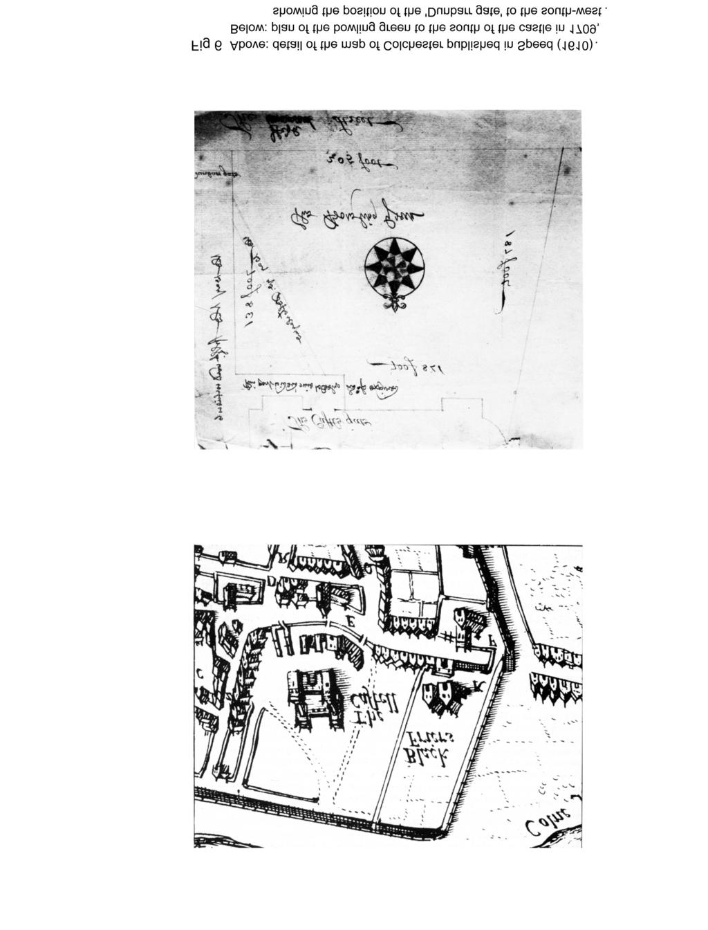
37
An archaeological watching brief at 97 High Street, Colchester, Essex March 2010
 An archaeological watching brief at 97 High Street, Colchester, Essex March 2010 report prepared by Donald Shimmin on behalf of Flying Trade Group plc CAT project ref.: 10/3a Colchester and Ipswich Museums
An archaeological fieldwalking evaluation at Tile House Farm, Great Horkesley, Essex July-September 2005
 An archaeological fieldwalking evaluation at Tile House Farm, Great Horkesley, Essex commissioned by ADP Chartered Architects on behalf of The Ingleton Properties Ltd and Mersea Homes CAT project code:
An archaeological watching brief at the Sixth Form College, North Hill, Colchester, Essex
 An archaeological watching brief at the Sixth Form College, North Hill, Colchester, Essex July 2001 on behalf of Colchester Borough Council CAT project ref.: 01/7B Colchester Museum accession code: 2001.126
An archaeological excavation at 193 High Street, Kelvedon, Essex September 2009
 An archaeological excavation at 193 High Street, Kelvedon, Essex September 2009 report prepared by Ben Holloway and Howard Brooks on behalf of Marden Homes CAT project ref.: 09/4g NGR: TL 8631 1913 (c)
An archaeological watching brief on land adjacent to 50 Rosebery Avenue, Colchester, Essex May/June 2003
 An archaeological watching brief on land adjacent to 50 Rosebery Avenue, Colchester, Essex May/June 2003 report prepared by C Crossan on behalf of Highfield Homes Ltd NGR: TM 0035 2500 CAT project ref.:
An archaeological watching brief on a new cable trench at the Abbey Field sports pitches, Circular Road North, Colchester, Essex October 2006
 An archaeological watching brief on a new cable trench at the Abbey Field sports pitches, Circular Road North, Colchester, Essex report prepared by Ben Holloway on behalf of Atkins Defence CAT project
An archaeological evaluation at 19 Beverley Road, Colchester, Essex February 2003
 An archaeological evaluation at 19 Beverley Road, Colchester, Essex February 2003 report prepared by Carl Crossan on behalf of Mr G and Mrs H Prince NGR: TL 98655 24844 CAT project ref.: 03/2d Planning
ROUKEN GLEN: BANDSTAND 2015 DATA STRUCTURE REPORT
 ROUKEN GLEN: BANDSTAND 2015 DATA STRUCTURE REPORT Author (s) Ian Hill Editors Report Date June 2015 Working Partners Funders Phil Richardson East Renfrewshire Council East Renfrewshire Council, Heritage
An archaeological evaluation at 1 York Road, Earls Colne, Essex March 2009
 An archaeological evaluation at 1 York Road, Earls Colne, Essex March 2009 report prepared by Ben Holloway and Howard Brooks on behalf of Mr Kurt Manders CAT project ref.: 09/3a NGR: TL 8575 2888 HEM project
An archaeological evaluation at 14 Vineyard Street, Colchester, Essex March 2006
 An archaeological evaluation at 14 Vineyard Street, Colchester, Essex March 2006 report prepared by Ben Holloway commissioned by Colchester Borough Council CAT project code: 06/4b Colchester Museums accession
Gorse Stacks, Bus Interchange Excavations Interim Note-01
 Gorse Stacks, Bus Interchange Excavations 2015 Prepared for: Cheshire West & Chester Council Interim Note-01 1 Introduction & Summary Background Since c. 2000 investigations associated with redevelopment
Excavations in a Medieval Market Town: Mountsorrel, Leicestershire,
 Excavations in a Medieval Market Town: Mountsorrel, Leicestershire, by John Lucas Mountsorrel is situated 12 kms north of Leicester and forms a linear settlement straddling the A6, Leicester to Derby road.
Report on an archaeological watching brief at Thomas Lord Audley School, Monkwick, Colchester
 Report on an archaeological watching brief at Thomas Lord Audley School, Monkwick, Colchester July 2000 for WS Atkins Property Services Colchester Archaeological Trust 12 Lexden Road, Colchester, Essex
East Midlands Region LEICESTER 3/16 (E.62.A010) SK
 SK") LEICESTER City of Leicester 3/16 (E.62.A010) SK 5853 0433 12 NEW ST., CASTLE WARD, LEICESTER Cottage to the Rear of 12 New St., Castle Ward, Leicester - A Photographic Survey and Archaeological Watching
LEICESTER City of Leicester 3/16 (E.62.A010) SK 5853 0433 12 NEW ST., CASTLE WARD, LEICESTER Cottage to the Rear of 12 New St., Castle Ward, Leicester - A Photographic Survey and Archaeological Watching
An archaeological excavation and watching brief at the Musket Club, Homefield Road, Colchester, Essex December 2004-February 2005
 An archaeological excavation and watching brief at the Musket Club, Homefield Road, Colchester, Essex December 2004-February 2005 report prepared by Howard Brooks on behalf of RMPA and the MoD CAT project
Archaeological Investigations Project South East Region SOUTHAMPTON 2/842 (C.80.C004) SU
 SU") SOUTHAMPTON City of Southampton 2/842 (C.80.C004) SU 4382 1336 125 BITTERNE ROAD WEST, SOUTHAMPTON Report on the Archaeological Evaluation Excavation at 125 Bitterne Road West, Southampton Russel, A. D
SOUTHAMPTON City of Southampton 2/842 (C.80.C004) SU 4382 1336 125 BITTERNE ROAD WEST, SOUTHAMPTON Report on the Archaeological Evaluation Excavation at 125 Bitterne Road West, Southampton Russel, A. D
Archaeological Watching Brief on land at Alpha, Gore Road, Eastry, Kent July 2010
 Archaeological Watching Brief on land at Alpha, Gore Road, Eastry, Kent July 2010 SWAT. Archaeology Swale and Thames Archaeological Survey Company School Farm Oast, Graveney Road Faversham, Kent ME13 8UP
Draft Report. 7. Excavations in the temenos gateway, Area (TG5) Author - D. A. Welsby Period 1-2. Period 1. Period 2. Derek A.
 Author - D. A. Welsby Period 1-2. Period 1. Period 2. Derek A.") 7. Excavations in the temenos gateway, Area (TG5) Derek A. Welsby When Griffith excavated the temples at Kawa in 1929-31, work followed by that of Macadam and Kirwan in the winter of 1935-6, the temenos
7. Excavations in the temenos gateway, Area (TG5) Derek A. Welsby When Griffith excavated the temples at Kawa in 1929-31, work followed by that of Macadam and Kirwan in the winter of 1935-6, the temenos
Two recently-discovered Roman buildings in Colchester
 Essex Archaeology and History 23 (1992), 25-38 Two recently-discovered Roman buildings in Colchester by Stephen Benfield and Simon Garrod East Stockwell Street Early Roman occupation was observed in section
IMTO Italian Mission to Oman University of Pisa 2011B PRELIMINARY REPORT (OCTOBER-DECEMBER 2011)
") IMTO Italian Mission to Oman University of Pisa 2011B PRELIMINARY REPORT (OCTOBER-DECEMBER 2011) The 2011B research campaign took place in the area around Salut from October, 19 th, to December, 16 th.
IMTO Italian Mission to Oman University of Pisa 2011B PRELIMINARY REPORT (OCTOBER-DECEMBER 2011) The 2011B research campaign took place in the area around Salut from October, 19 th, to December, 16 th.
Northamptonshire Archaeology
 Northamptonshire Archaeology A programme of archaeological observation, investigation and recording at St Andrews Church, Spratton, Northamptonshire Northamptonshire Archaeology 2 Bolton House Wootton
FOREWORD. S. S. Frere. The Culver Street site in relation to the fortress (top) and the Roman city (below).
 and the Roman city (below).") THE BIG DIG BEGINS FOREWORD Colchester has always been seen as an important Roman site owing to its known status as a Roman colonia - the first of only four in the country - and owing to the presence there
THE BIG DIG BEGINS FOREWORD Colchester has always been seen as an important Roman site owing to its known status as a Roman colonia - the first of only four in the country - and owing to the presence there
An archaeological watching brief on a BT cable trench from Head Street to Southway, Colchester, Essex August-October 2006
 An archaeological watching brief on a BT cable trench from Head Street to Southway, Colchester, Essex report prepared by Donald Shimmin on behalf of British Telecom NGR: TL 9940 2510 CAT project ref.:
Department of Tourism, Culture and Recreation Provincial Archaeology Office 2012 Archaeology Review February 2013 Volume 11
 Department of Tourism, Culture and Recreation Provincial Archaeology Office 2012 Archaeology Review February 2013 Volume 11 Area 14 of FjCa-14 in Sheshatshiu, portion of feature in southeast corner of
In 2014 excavations at Gournia took place in the area of the palace, on the acropolis, and along the northern edge of the town (Fig. 1).
.") Gournia: 2014 Excavation In 2014 excavations at Gournia took place in the area of the palace, on the acropolis, and along the northern edge of the town (Fig. 1). In Room 18 of the palace, Room A, lined
Gournia: 2014 Excavation In 2014 excavations at Gournia took place in the area of the palace, on the acropolis, and along the northern edge of the town (Fig. 1). In Room 18 of the palace, Room A, lined
4. Bronze Age Ballybrowney, County Cork Eamonn Cotter
 4. Bronze Age Ballybrowney, County Cork Eamonn Cotter Illus. 1 Location map of the excavated features at Ballybrowney Lower (Archaeological Consultancy Services Ltd, based on the Ordnance Survey Ireland
FOUNDATIONS OF ARCHAEOLOGY A WALK IN VERNDITCH CHASE
 FOUNDATIONS OF ARCHAEOLOGY A WALK IN VERNDITCH CHASE 1. A Tale of two Long Barrows Long barrows were constructed as earthen or drystone mounds with flanking ditches and acted as funerary monuments during
Wessex Archaeology. Little Stubbings, West Amesbury, Salisbury, Wiltshire. Archaeological Watching Brief. Ref:
 Wessex Archaeology Little Stubbings, West Amesbury, Salisbury, Wiltshire Ref: 63280.02 March 2007 LITTLE STUBBINGS, WEST AMESBURY, NR SALISBURY, WILTSHIRE ARCHAEOLOGICAL WATCHING BRIEF Prepared for: P
Land off Birdie Way, Rush Green, Hertford, Hertfordshire
 Land off Birdie Way, Rush Green, Hertford, Hertfordshire An Archaeological Evaluation for Bride Hall Development Limited by Sarah Coles Thames Valley Archaeological Services Site Code RGH00/ 01 January
Archaeological Watching Brief at the Brick Stables and Wagon Lodge, Abbey Barns, Abbey Road, Faversham, Kent September 2010
 Archaeological Watching Brief at the Brick Stables and Wagon Lodge, Abbey Barns, Abbey Road, Faversham, Kent September 2010 SWAT. Archaeology Swale and Thames Archaeological Survey Company School Farm
BRONZE AGE FIELD SYSTEM AT SOUTHAMPTON AIRPORT
 Proc. Hampshire Field Club Archaeol. Soc. 65, 2010, 1-6 (Hampshire Studies 2010) BRONZE AGE FIELD SYSTEM AT SOUTHAMPTON AIRPORT By J SULIKOWSKA With contributions by LORRAINE MEPHAM and CHRIS J STEVENS
Archaeological Monitoring at Ham Farm, Ham Road, Faversham, Kent
 Archaeological Monitoring at Ham Farm, Ham Road, Faversham, Kent NGR: 601750.0mE 162695.0mN Site Code HAM/WB/12 Report for A.J. Bray SWAT ARCHAEOLOGY Swale and Thames Archaeological Survey Company The
ROUKEN GLEN: MANSION HOUSE 2013 DATA STRUCTURE REPORT
 ROUKEN GLEN: MANSION HOUSE 2013 DATA STRUCTURE REPORT Author (s) Editors Report Date May 2014 Working Partners Funders Paul Murtagh Phil Richardson East Renfrewshire Council East Renfrewshire Council,
Following the initial soil strip archaeology is sprayed up prior to planning and excavation
 Barton Quarry & Archaeology Over the past half century quarries have been increasingly highlighted as important sources of information for geologists, palaeontologists and archaeologists, both through
New Studies in the City of David The Excavations
 The 2013-2014 Excavations Israel Antiquities Authority The intensive archaeological work on the city of David hill during the period covered in this article has continued in previously excavated areas
Archaeological Evaluation Report
 Holywell House Osney Mead Oxford o a November 2007 Client: Knowles and Son Issue N o : 1 OA Job N o : 3826 Planning Ref N o : 02/01800/FUL NGR: SP 502 055 Client Name: Knowles and Son Client Ref No: Document
South East Region SOUTHAMPTON 3/1050 (E.80.H006) SU
 SU") SOUTHAMPTON 3/1050 (E.80.H006) SU 43351328 16 HAWKESWOOD ROAD Report on the Archaeological Observations at 16 Hawkeswood Road, Bitterne Manor Russil, A & Smith, M Southampton : Southampton City Council
SOUTHAMPTON 3/1050 (E.80.H006) SU 43351328 16 HAWKESWOOD ROAD Report on the Archaeological Observations at 16 Hawkeswood Road, Bitterne Manor Russil, A & Smith, M Southampton : Southampton City Council
archaeological evaluation of sites to the west of the castle in 1988
 FLNT CASTLE archaeological evaluation of sites to the west of the castle in 1988 -.., - w -... " - Clwyd-Powys Archaeological Trust '.. - Flint Castle, Delyn: evaluation of sites west of the castle in
Holyport Manor Special School, Highfield Lane, Cox Green, Maidenhead, Berkshire
 Holyport Manor Special School, Highfield Lane, Cox Green, Maidenhead, Berkshire An Archaeological recording action For CgMs Consulting by Jennifer Lowe Thames Valley Archaeological Services Ltd Site Code
Contents. Crossrail Limited RESTRICTED. Summary of LSS85 archive Broadgate Excavations C257-MLA-T1-XTC-C101_WS
 Summary of LSS85 archive Broadgate Excavations Contents 1 Purpose...4 2 Scope...4 3 Definitions...4 4 LSS85 Archive Summary Report...4 5 Summary Data - Burials found in Liverpool Street...5 6 Note from
Street Sweeper Dump Site, RAF Lakenheath ERL 160
 ARCHAEOLOGICAL MONITORING REPORT Street Sweeper Dump Site, RAF Lakenheath ERL 160 A REPORT ON THE ARCHAEOLOGICAL MONITORING, 2006 (Planning app. no. F/2006/0021/GOV) Jo Caruth Field Team Suffolk C.C. Archaeological
Wheatlands House, Fleet Hill, Finchampstead, Berkshire
 Wheatlands House, Fleet Hill, Finchampstead, Berkshire An Archaeological Watching Brief For JCA International by James McNicoll-Norbury Thames Valley Archaeological Services Ltd Site Code WFF 08/26 August
Pen-y-gaer Roman Vicus, Cwmdu, Powys: Draft Interim Report
 CPAT Report No 1107 Pen-y-gaer Roman Vicus, Cwmdu, Powys: ARCHAEOLOGICAL EXCAVATION THE CLWYD-POWYS ARCHAEOLOGICAL TRUST CPAT Report No 1107 Pen-y-gaer Roman Vicus, Cwmdu, Powys: ARCHAEOLOGICAL EXCAVATION
Cholesbury New House, Parrots Lane, Cholesbury, Buckinghamshire
 Cholesbury New House, Parrots Lane, Cholesbury, Buckinghamshire An Archaeological Watching Brief For Mr Martin Wood by Sean Wallis Thames Valley Archaeological Services Ltd Site Code PLC 06/135 March 2007
Trench 91 revealed that the cobbled court extends further to the north.
 Report on the 2013 Gournia Excavations The 2013 excavations at Gournia were conducted June 17 July 26 under the aegis of the American School of Classical Studies at Athens and the supervision of the KD
The Greek-Swedish-Danish Excavations at Kastelli, Khania 2010 a short report
 The Greek-Swedish-Danish Excavations at Kastelli, Khania 2010 a short report During six weeks from 19 July to 27 August the Greek-Swedish-Danish Excavations continued work in the Ag. Aikaterini Square
Deddington Castle, Oxfordshire: A Summary of Excavations *
 Deddington Castle, Oxfordshire: A Summary of Excavations 1977 1979* R.J. Ivens for Queen s University, Belfast, and DoE Between 1947 and 1951 Prof. E.M. Jope carried out a series of rescue excavations
South East WEST SUSSEX 3/1146 (E ) SU
 SU") WEST SUSSEX Arun 3/1146 (E.45.6000) SU 97370032 'GREENFIELDS', MIDDLETON-ON-SEA 'Greenfields', Middleton-on-Sea, West Sussex. Archaeological Excavation Saunders, M J Reading : Thames Valley Archaeological
WEST SUSSEX Arun 3/1146 (E.45.6000) SU 97370032 'GREENFIELDS', MIDDLETON-ON-SEA 'Greenfields', Middleton-on-Sea, West Sussex. Archaeological Excavation Saunders, M J Reading : Thames Valley Archaeological
Archaeological monitoring and recording at DSG (Defence Support Group), Flagstaff Road, Colchester, Essex, CO2 7SR
, Flagstaff Road, Colchester, Essex, CO2 7SR") Archaeological monitoring and recording at DSG (Defence Support Group), Flagstaff Road, Colchester, Essex, CO2 7SR October 2017 by Laura Pooley figures by Laura Pooley and Sarah Carter fieldwork by Nigel
Archaeological monitoring and recording at DSG (Defence Support Group), Flagstaff Road, Colchester, Essex, CO2 7SR October 2017 by Laura Pooley figures by Laura Pooley and Sarah Carter fieldwork by Nigel
archeological site LOS MILLARES
 archeological site LOS MILLARES Aerial view of the plain of Los Millares between the Rambla de Huéchar and the River Andarax The archaeological site of Los Millares is located in the township of Santa
A FIELDWALKING PROJECT AT HOLLINGBURY, BRIGHTON. by JOHN FUNNELL
 Introduction A FIELDWALKING PROJECT AT HOLLINGBURY, BRIGHTON by JOHN FUNNELL Members of the Brighton and Hove Archaeological Society walked the field at Hollingbury during the months of December 1991 and
Archaeological Investigations Project Eastern Region. Essex 2/197 (C.22.F025) TL
 TL") Essex Braintree 2/197 (C.22.F025) TL 75502284 BLANDFORD HOUSE, 7 LONDON ROAD, BRAINTREE Blandford House, 7 London Road, Braintree, Essex Davis, E Chelmsford : Essex County Council Field Archaeology Unit,
Essex Braintree 2/197 (C.22.F025) TL 75502284 BLANDFORD HOUSE, 7 LONDON ROAD, BRAINTREE Blandford House, 7 London Road, Braintree, Essex Davis, E Chelmsford : Essex County Council Field Archaeology Unit,
Newbold Hall, Rochdale. An Archaeological Excavation
 School of the Built Environment CUBE Building, University of Salford 113-115 Portland Street Manchester M1 6DW Tel: 0161 295 3818 Email: m.d.nevelle@salford.ac.uk Web: www.cfaa.co.uk Newbold Hall, Rochdale.
The Coach House, Mill Lane, Cookham, Berkshire
 The Coach House, Mill Lane, Cookham, Berkshire An Archaeological Watching Brief For Ms Sophia Butler by Stephen Hammond Thames Valley Archaeological Services Ltd Site Code CMC 03/104 October 2003 Summary
Florence House, High Street, Hurley, Berkshire
 Florence House, High Street, Hurley, Berkshire An Archaeological Watching Brief For Mr Michael Waterhouse by Jo Pine Thames Valley Archaeological Services Ltd Site Code FHH04/52 May 2004 Summary Site name:
South East SOUTHAMPTON
 Southampton SOUTHAMPTON 3/1056 (E.80.M010) SU 44181114 SO19 7PE 1 FOREST VIEW, SOUTHAMPTON Report on the Archaeological Watching Brief at 1 Forest View, Southampton, SOU 1232 Leivers, M Southampton : Southampton
Manor Farm, Wilcot, Pewsey, Wiltshire
 Manor Farm, Wilcot, Pewsey, Wiltshire An Archaeological Evaluation for Mr W. Madiment by Helen Moore Thames Valley Archaeological Services Ltd Site Code MFP02/78 September 2002 Summary Site name: Manor
IKLAINA ARCHAEOLOGICAL PROJECT 2016 FIELD REPORT Michael B. Cosmopoulos
 IKLAINA ARCHAEOLOGICAL PROJECT 2016 FIELD REPORT Michael B. Cosmopoulos Introduction The overarching objective of the Iklaina project is to test existing hierarchical models of state formation in Greece
Provincial Archaeology Office Annual Review
 2017 Provincial Archaeology Office Annual Review Provincial Archaeology Office Department of Tourism, Culture, Industry and Innovation Government of Newfoundland and Labrador March 2018 Volume 16 A brief
The Yingtianmen Gate-site of the Sui and Tang Eastern Capital in Luoyang City
 Nandajie The Yingtianmen Gate-site of the Sui and Tang Eastern Capital in Luoyang City Tang Luoyang City-site Archaeological Team, Institute of Archaeology, Chinese Academy of Social Sciences Key words:
Investigations at Jackdaw Crag Field, Boston Spa, SE , in by Boston Spa Archaeology and Heritage Group
 0 Investigations at Jackdaw Crag Field, Boston Spa, SE 42304632, in 2006-7 by Boston Spa Archaeology and Heritage Group www.bostonspaheritage.co.uk Preface and Summary This report records the results of
o a London Borough of Barnet Stoney Wood Lake Silk Stream Flood Alleviation Scheme Archaeological Watching Brief Report Oxford Archaeology
 Silk Stream Flood Alleviation Scheme Stoney Wood Lake London Borough of Barnet Archaeological Watching Brief Report o a Oxford Archaeology November 2004 Client: Halcrow on behalf of Environment Agency
The Old Shire Horse Centre, Bath Road, Woolley Green, Maidenhead, Berkshire
 The Old Shire Horse Centre, Bath Road, Woolley Green, Maidenhead, Berkshire An Archaeological Watching Brief For Mr Derek Chesterman by Andrew Mundin Thames Valley Archaeological Services Ltd Site Code
Aylesbury Masonic Hall, Ripon Street, Aylesbury, Buckinghamshire
 Aylesbury Masonic Hall, Ripon Street, Aylesbury, Buckinghamshire An Archaeological Recording Action for Wakefield Building Services by Andrew Mundin Thames Valley Archaeological Services Ltd Site Code
Archaeological evaluation at Building H11, Colchester Garrison Area A1 (former Meeanee & Hyderabad Barracks), Mersea Road, Colchester, Essex
, Mersea Road, Colchester, Essex") Archaeological evaluation at Building H11, Colchester Garrison Area A1 (former Meeanee & Hyderabad Barracks), Mersea Road, Colchester, Essex October 2013 report prepared by Ben Holloway and Howard Brooks
Archaeological evaluation at Building H11, Colchester Garrison Area A1 (former Meeanee & Hyderabad Barracks), Mersea Road, Colchester, Essex October 2013 report prepared by Ben Holloway and Howard Brooks
Henderson Mess, RAF Halton, Buckinghamshire
 Henderson Mess, RAF Halton, Buckinghamshire An archaeological watching brief for Stepnell Ltd by Stephen Hammond Thames Valley Archaeological Services Ltd Site Code RHA03/85 October 2003 Summary Site name:
Culver Street-First Results
 The story of Colchester Shortly after the start of the Roman invasion of Britain in AD 43, a legionary fortress was founded in the heart of the Iron Age capital 'Camulodunum'. A few years later, the garrison
218 R. S. BORAAS AND S. H. HORN
 were able to show a sequence of ceramic corpora much more fully representative than those available from the occupation surfaces and structures higher on the mound. This ceramic series obtained from D.
Archaeological recording at 1 Mossfield Close, Colchester, Essex, CO3 3RG
 Archaeological recording at 1 Mossfield Close, Colchester, Essex, CO3 3RG May 2017 by Dr Elliott Hicks figures by Sarah Carter fieldwork by Sarah Carter Commissioned by Paul Neville NGR: TL 98014 24940
Excavations at Vagnari 2017
 Excavations at Vagnari 2017 Maureen Carroll Since 2012, our excavations at the Roman imperial estate at Vagnari in Puglia (Fig. 1) have concentrated on the northern edge of the village (vicus) of the estate
Afon Adda Refurbishment Bangor
 Afon Adda Refurbishment Bangor Archaeological Assessment Revised Report GAT Project No. 1876 Report No. 628 April 2006 Ymddiriedolaeth Archaeolegol Gwynedd Gwynedd Archaeological Trust Craig Beuno, Ffordd
Chapter 4 Research on Block 13, Lots 3 and 4
 Chapter 4 Research on Block 13, Lots 3 and 4 George Calfas History Block 13, Lots 3 and 4 Oral history and the written record Squire McWorter acquired the deed to Block 13, Lots 3 and 4 in 1854. Squire
PONTOP SMITHY DIPTON, COUNTY DURHAM
 PONTOP SMITHY DIPTON, COUNTY DURHAM ~ ARCHAEOLOGICAL EXCAVATION ~ OCTOBER 2016 Prepared for: Land of Oak & Iron Landscape Partnership By: The Archaeological Practice Ltd. Project code: AP 16/43 Stage:
BRONZE-AGE FOOD VESSEL (b) USED AS A BURIAL URN BROWN CANDOVER, [To face page 249]
![BRONZE-AGE FOOD VESSEL (b) USED AS A BURIAL URN BROWN CANDOVER, [To face page 249]](/thumbs/93/118018967.jpg "BRONZE-AGE FOOD VESSEL (b) USED AS A BURIAL URN BROWN CANDOVER, [To face page 249]") BRONZE-AGE FOOD VESSEL (b) USED AS A BURIAL URN BROWN CANDOVER, HANTS [To face page 249] 249 TWO BRONZE AGE DISCOVERIES IN HANTS. BY S. E. WlNBOLT, M.A. (i.) Brown Candover. East of the road at Brown Candover,
BRONZE-AGE FOOD VESSEL (b) USED AS A BURIAL URN BROWN CANDOVER, HANTS [To face page 249] 249 TWO BRONZE AGE DISCOVERIES IN HANTS. BY S. E. WlNBOLT, M.A. (i.) Brown Candover. East of the road at Brown Candover,
ANNUAL REPORT: ANCIENT METHONE ARCHAEOLOGICAL PROJECT 2014 FIELD SCHOOL
 ANNUAL REPORT: ANCIENT METHONE ARCHAEOLOGICAL PROJECT 2014 FIELD SCHOOL Director(s): Co- Director(s): Professor Sarah Morris, Cotsen Institute of Archaeology, UCLA John K. Papadopoulos, Cotsen Institute
A487 PONT SEIONT ARCHAEOLOGICAL RECORDING REPORT NO Y mddiriedolaeth Archaeolegol Gwynedd Gwynedd Archaeological Trust
 A487 PONT SEIONT ARCHAEOLOGICAL RECORDING REPORT NO. 148 Y mddiriedolaeth Archaeolegol Gwynedd Gwynedd Archaeological Trust A487 PONT SEIONT ARCHAEOLOGICAL RECORDING prepared for Welsh Office Highways
St. Patrick s Street Development Brief
 St. Patrick s Street Development Brief Bardas Chorcai Cork Corporation August 2001 Contents Introduction and background The Development Brief Area Protected and valuable buildings Urban context Objectives
NORTH YORKSHIRE 2/1340 (C ) SE
 SE") NORTH YORKSHIRE Craven 2/1339 (C.36.6001) SD 97606975 SD 94507750 KILNSEY TO BUCKDEN WATER PIPELINE Kilnsey to Buckden Water Pipeline, North Yorkshire. Geophysical Survey (Report no. 841) Webb, A Leeds
NORTH YORKSHIRE Craven 2/1339 (C.36.6001) SD 97606975 SD 94507750 KILNSEY TO BUCKDEN WATER PIPELINE Kilnsey to Buckden Water Pipeline, North Yorkshire. Geophysical Survey (Report no. 841) Webb, A Leeds
Monitoring Report No. 119
 SITE OF THE OMAGH WORKHOUSE AND FEVER HOSPITAL OMAGH COUNTY TYRONE LICENCE NO.: AE/07/29 BRIAN SLOAN 1 Site Specific Information Site Name: Omagh General Hospital Townland: Lisnamallard SMR No. : N/A State
Stage 1b archaeological evaluation, Alienated Land Area H, Colchester Garrison, Colchester, Essex January-February 2007
 Stage 1b archaeological evaluation, Alienated Land Area H, Colchester Garrison, Colchester, Essex report prepared by Howard Brooks and Ben Holloway on behalf of Taylor Woodrow CAT project code: 06/10d
Instruction Manual. A step-by-step guide to building your own igloo. Andy Meldrum All rights are reserved.
 Instruction Manual A step-by-step guide to building your own igloo. Andy Meldrum 2007 1 Contents 1 Introduction 2 Get properly kitted up. 3 Choose and prepare your site. 4 Create the base. 5 Mark out the
Archaeological Investigations Project East Midlands Region NORTHAMPTONSHIRE
 NORTHAMPTONSHIRE 2/92 (C.34.A002) WAKEFIELD LODGE Wakefield Lodge, Northamptonshire. Archaeological Walkover Survey Bashford, D & Croft, A Oxford : Oxford Archaeology, 2001, 15pp, figs, tabs, refs Work
Plates. Kom Firin I 193. Plate 96 View of the southwestern part of Kom Firin, looking west-southwest.
 Plates Plate 96 View of the southwestern part of Kom Firin, looking west-southwest. Plate 97 Ramesside temple: wall 0157 and clean sand 0189 (TG), view to north. Plate 98 Ramesside temple: wall 0135 (TD),
The Archaeology of Cheltenham
 The Archaeology of Cheltenham The archaeology collection of The Wilson contains a rich quantity of material relating to the prehistoric and Roman occupation of the North Cotswolds and parts of the Severn
Excavations at Cadbury Camp Congresbury, Somerset
 Excavations at Cadbury Camp Congresbury, Somerset Keith S Gardner (with notes by Vince Russett) Clevedon and District Archaeological Society 1959 Note: This report formerly existed only in a hand-written
THE EL-QITAK PROJECT. oi.uchicago.edu
 oi.uchicago.edu THE EL-QITAK PROJECT T H O M A S - L - M C C L E L L A N T he 1987 season at el-qitar ran from May 2 t o July 29th and marked the last major season of excavation there because the site
TH E FIRST SEASON of investigations at the
 QUSEIR AL-QADIM Janet H. Johnson & Donald Whitcomb TH E FIRST SEASON of investigations at the ancient port of Quseir al-qadim on the Red Sea in Egypt took place in winter, 1978; the investigations were
Unlocking Our Coastal Heritage Project: Crane Castle Promontory Fort, Illogan, Cornwall
 Unlocking Our Coastal Heritage Project: Crane Castle Promontory Fort, Illogan, Cornwall As part of a wider project funded by the Rural Development Programme for England (RDPE) and administered through
Erica Kinias Brown University, Department of the History of Art and Architecture
 Erica Kinias Brown University, Department of the History of Art and Architecture Archaeological Institute of America Jane C. Waldbaum Scholarship Fund Research Outcomes With the generous support from the
oi.uchicago.edu TALL-E BAKUN
 TALL-E BAKUN ABBAS ALIZADEH After I returned in September 1991 to Chicago from Cambridge, Massachusetts, I began preparing for publication the results of 1937 season of excavations at Tall-e Bakun, one
THE HEUGH LINDISFARNE
 LINDISFARNE COMMUNITY ARCHAEOLOGY THE HEUGH LINDISFARNE Archaeological excavations in June 2017 Invitation to volunteers THE HEUGH, LINDISFARNE, NORTHUMBERLAND: ARCHAEOLOGICAL EXCAVATIONS 2017 INTRODUCTION
Cambridge Castle Mound
 Cambridge Castle Mound Archaeological Watching Brief Report August 2013 Client: Cambridgeshire County Council OA East Report No: 1519 OASIS No: oxfordar3-172998 NGR: TL 4457 5919 Archaeological Watching
Jneneh in the Upper Wadi az-zarqa, in North Central Jordan, First Season 2011.
 Jneneh in the Upper Wadi az-zarqa, in North Central Jordan, First Season 2011. Khaled Douglas Jneneh is located in the north-western periphery of the city of Zarqa (grid ref. 250.88E 165.25N), in North
Department of Archaeology. Silchester Insula IX. The Town Life Project Michael Fulford & Amanda Clarke
 Department of Archaeology Silchester Insula IX The Town Life Project 2006 2009 Michael Fulford & Amanda Clarke We have now completed 12 seasons of excavations of Insula IX, the city block which lies immediately
FORMER COUNTY OF SOUTH YORKSHIRE
 FORMER COUNTY OF SOUTH YORKSHIRE Barnsley 3/1883 (E.04.6010) SE 36491121 4 CHURCH HILL, ROYSTON 4 Church Hill, Royston, South Yorkshire. Archaeological Watching Brief (Report No. 868) O'Neill, R Leeds
BROOKLYN COLLEGE EXCAVATIONS AT THE NEW UTRECHT REFORMED CHURCH
 BROOKLYN COLLEGE EXCAVATIONS AT THE NEW UTRECHT REFORMED CHURCH SUMMER 2002 The New Utrecht Reformed Church is the fourth oldest church in Brooklyn. Founded in 1677, in the heart of the Dutch town of New
: southern pilaster of the entrance. The tomb owner, Redi, is depicted in painted raised relief ( a 8014) Plate 15
 Plate 15") 15. 2086: southern pilaster of the entrance. The tomb owner, Redi, is depicted in painted raised relief ( a 8014) Plate 15 16. 2086: south wall. Redi is seated with a woman, receiving a lotus, and entertained
15. 2086: southern pilaster of the entrance. The tomb owner, Redi, is depicted in painted raised relief ( a 8014) Plate 15 16. 2086: south wall. Redi is seated with a woman, receiving a lotus, and entertained
archaeological site GADES Columbaria Roman Theatre Salting Factory
 archaeological site GADES Columbaria Roman Theatre Salting Factory In the final days of the Roman Republic and the early years of Augustus rule, the city of Gades experienced a period of economic and political
Shallow IC of 5
 Shallow IC 250 1 of 5 Description 250mm diameter polypropylene inspection chamber for adoptable and non-adoptable applications. Compliant with Sewers for Adoption 7th edition [SfA7]. Single unit with integral
Architectural Analysis in Western Palenque
 Architectural Analysis in Western Palenque James Eckhardt and Heather Hurst During the 1999 season of the Palenque Mapping Project the team mapped the western portion of the site of Palenque. This paper