U3A WALK Harby Hose. Route Summary. Route Overview. Description. Waypoints. Harby. Stuart Galloway
|
|
|
- Arnold Derrick Hampton
- 5 years ago
- Views:
Transcription

. It is in the parish of Clawson, Hose and Harby. Also known as Hedeby and Herdebi in past. Origin of name is old Scandinavian.( probably Danish).")
1 U3A WALK Harby Hose Stuart Galloway Route Summary A circular walk taking in Harby, Hose and the Grantham Canal. Route Overview Category: Walking Length: km / 4.57 mi Parking: Village Hall School Lane Date Published: 27th May 2016 Difficulty: Medium Rating: Unrated Surface: Average Last Modified: 27th May 2016 Description Parking in the Village Hall car park, School Lane Harby. Walk is based upon a Local Walk around Harby from choosehowyoumove.co.uk with a mile or so extension. Waypoints Harby ( ; ) Harby has a population of 300. (was 600+ back in 1850). It is in the parish of Clawson, Hose and Harby. Also known as Hedeby and Herdebi in past. Origin of name is old Scandinavian.( probably Danish). Village cross just down the road from the school has the name Herdebi,on it. In Domesday Book of 1086 land in the area owned by Robert de Tosny (from the Rouen area in France) he also responsible for building the 1st Belvoir Castle (Belvoir is French for beautiful view)and Robert de Bucy. The Quaker movement was prominent in the mid 1600 s but due to discrimination of the movement many left the area and migrated to US. (Pennsylvania) Two such families from the village Garrett and Lewis became very wealthy and highly respected citizens of US. 1 / 5
2 50 people left the parish in and migrated to Australia. The village had originally 3 pubs but only 1 remains today the Nags Head. This pub is believed to be one of oldest in the county and maybe the country. Parts of the pub date back almost 400 years and part of it was originally a priory. The other 2 were the White Heart across the road from the Nags and the Marquis of Granby that was closed in 1875 Turn left out of the car park and walk along School Lane until you see the school on your left. The School ( ; ) The school has interesting history. It was built around 1827 on land given to village by 5th Duke of Rutland. School run by the National Society for promoting religious education in schools across UK for children from poor families. There were 12,000 such schools in existence when the state took control of schools in It was extended in The Church of St. Mary the Virgin can be reached via a track by the school. It is the oldest building in village constructed in the late 13th Century. The tower dates from 1610 and has 5 bells.. It was restored in It seats 220 people. There are a number of grotesque stone carvings to be seen. Continue along School Lane and then turn left into Stathern Road. Walk along the road until you reach Green Lane and turn right into the lane. Continue and this track/path until you meet a junction of five paths. Turn right here and continue along this path until you enter Hose Lane. Hose ( ; ) In Domrsday book the village was known as Hoches or Howes. The name derives from an Old English hohas or hogas which is plural of hoh meaning hioll or spur of land. As a village, Hose probably came into existence in the late Saxon period (10th - 11th centuries), but evidence of life in the area can be traced back much further than this.less than a mile to the south of the parish boundary are a group of Bronze Age burial mounds (1500 BC). whilst scattered flints etc have been found in several parts of the parish. From the Iron Age, very little remains, except for a prehistoric trackway, which forms part of the parish boundary to the north-east but once we get to the Roman period (1st - 4th centuries AD), there is extensive evidence of occupation, with two definite and two probable Roman-British farmsteads being known in the parish (one of them underlying parts of the present village). The Dark Ages are - as usual - dark, and the next reliable evidence we have is in the form of late Saxon pottery, which shows that a village as we think of it today has appeared by the 10th - 11th centuries, with a Saxon "manor house" at 2 / 5
3 one end and a church at the other.the first real written evidence comes with the Domesday Book, from which we can see that something peculiar has been happening in Hose during the late Saxon period, because when Hose is compared with other villages in NE Leicestershire we find that it had a majority of Saxons, a higher percentage of slaves and the lowest percentage of Vikings living in it, than any other village in the area. It was also the most productive. Why the Saxons appear to have maintained the ascendancy in Hose, when they failed to do so in any of the other villages - and whether the productivity is related to this - is anybody's guess. The real reason will probably be knowm. Turn Left into Bolton Lane and walk until you see the church and school on your right. Church and Later Village History ( ; ) From the 12th century onwards, evidence survives in ever-increasing quantities. The manor house eventually came into the hands of the Charnels, but was destroyed as a result of an inheritance dispute in 1377, with the Sheriff being ordered to go and inspect the site to ascertain the amount of damage done. The outline of the site can still be traced by the surrounding roads and paths, within which the foundations of one wall and wild damson bushes (the descendants of its medieval orchard) still remains. Traces of 14th century village planning can be seen in the shape of the long thin gardens behind the houses on Bolton Lane, earthworks belonging to a grange owned by Croxton Abbey remain to the west of the village, and the effect of the Black Death can be seen by looking at the list of vicars displayed in the church - three died in the 5 years between 1348 and Since then the village has shrunk and grown in turns, being influenced by most of the events which comprise the march of progress or civilisation: from the enclosure of the fields, to the building of the canals; the rise of nonconformist churches; the coming of the railway; the development of a proper road system. Continue along Bolton Lane and bear sharp right until you meet Meadows Lane where you turn left. Continue until you meet the Gratham Canal. Grantham Canal ( ; ) Opened in 1798 and closed in Built to take coal from Notts/Derby/Leics coalfields to Grantham. Built at a todays cost of 7.5 million It is 33 miles in length and had 18 locks. A nearby railway was opened in 1879 and along with the canal provided transport for the nearby Ironstone mines. 3 / 5
4 However it was the arrival of the railways that eventually saw thr demise of not only the Grantham Canal but many others across the country. Since 1970 the Grantham Canal Trust has been working hard to restore stretches of the canal. Two are now navigable for small vessels. After bridge 40 look out on the right for the Harby Windmill built in Originally 7 storeys high but had the sails and the top 3 storeys removed in This was to give sufficient clearance for heavily laden bombers to land at Langar Airfield over to your left. From 1952 until 1963 the Royal Canadian Airforce were based at Langar. A number of Canadian families lived in Harby and surrounding villages. Infact the Nags Head was run by a Canadian and his wife (local I think) for a number of years. There was a brewery at Langar Bridge but was demolished. Continue along the towpath until bridge 43 and turn right onto Langer Lane which will take you back to Harby. 4 / 5
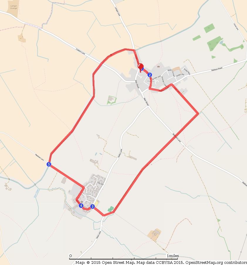
5 5 / 5
The Archaeology of Cheltenham
 The Archaeology of Cheltenham The archaeology collection of The Wilson contains a rich quantity of material relating to the prehistoric and Roman occupation of the North Cotswolds and parts of the Severn
Gors Lydan barrows and medieval huts
 Walk Information: Maps: OS Explorer 214 Distance: 5.5 miles / 9 kilometres Duration: 4.5 to 5 hours Difficulty: Easy. Good paths and no steep gradients Start and finish: SO 11977545 Walk summary The walk
Brenig Archaeology Trail
 Walk Information: Maps: OS Explorer 264 Distance: 2.5 miles / 4 kilometres Duration: Allow 2.5 hours for the circular walk Difficulty: easy. Well-marked trail over fields. Start and finish: SH 98325741
Chiselbury Camp hillfort
 Chiselbury Camp hillfort Reasons for Designation Large univallate hillforts are defined as fortified enclosures of varying shape, ranging in size between 1ha and 10ha, located on hilltops and surrounded
Pen Cerrig-calch prehistoric cairns
 Walk Information: Maps: OS Explorer OL13 Distance: 8 miles / 13 kilometres Duration: Allow at least 6 hours for the circular walk Difficulty: medium. Some narrow paths, occasionally rough underfoot Start
U3A WTT Bagworth. Route Summary. Route Overview. Description. Waypoints. Sculpture. Stuart Galloway. A circular walk around Bagworth.
 U3A WTT Bagworth Stuart Galloway Route Summary A circular walk around Bagworth. Route Overview Category: Walking Length: 6.450 km / 4.03 mi Parking: Bagworth Heath Date Published: 27th April 2016 Difficulty:
Woodland Walk If you enjoyed this walk there are two others available in the same area.
 The Woodland Walk 11-12 kilometres (7-8 miles) 4-5 hours Terrain: some easy hills Can be slippery when wet 5 stiles Unsuitable for a pushchair/wheelchair Uses OS map 197 Parking: Pulborough Station and
WALKS AROUND WOODHURST
 WALKS AROUND WOODHURST With Walks To Woodhurst from North St. Ives Woodhurst is situated on the verge of an elevated tract of table land four miles north of St. Ives. Its footpaths vary from leafy lanes
FOUNDATIONS OF ARCHAEOLOGY A WALK IN VERNDITCH CHASE
 FOUNDATIONS OF ARCHAEOLOGY A WALK IN VERNDITCH CHASE 1. A Tale of two Long Barrows Long barrows were constructed as earthen or drystone mounds with flanking ditches and acted as funerary monuments during
Eglwyseg Mountain a landscape of prehistoric cairns and later industry
 Eglwyseg Mountain a landscape of prehistoric cairns and later industry Walk Information: Maps: OS Explorer 256 Distance: 5.3 miles / 8.5 kilometres (linear) or up to 9.6 miles / 15.5 kilometres (circular)
2. 4 Avebury: stone circles and nearby sites
 24 2. 4 Avebury: stone circles and nearby sites N E W S Beckhampton Avenue The bank originally stood 7 m (23 ft) high, much taller than today. The ditch was originally 9 m (30 ft) deep and 20 m (65 ft)
CASTLE OF OLD WICK HISTORIC ENVIRONMENT SCOTLAND STATEMENT OF SIGNIFICANCE. Property in Care(PIC) ID: PIC282 Designations:
 ID: PIC282 Designations:") Property in Care(PIC) ID: PIC282 Designations: Scheduled Monument (SM90065) Taken into State care: 1957 (Guardianship) Last reviewed: 2004 HISTORIC ENVIRONMENT SCOTLAND STATEMENT OF SIGNIFICANCE CASTLE
Property in Care(PIC) ID: PIC282 Designations: Scheduled Monument (SM90065) Taken into State care: 1957 (Guardianship) Last reviewed: 2004 HISTORIC ENVIRONMENT SCOTLAND STATEMENT OF SIGNIFICANCE CASTLE
Following the initial soil strip archaeology is sprayed up prior to planning and excavation
 Barton Quarry & Archaeology Over the past half century quarries have been increasingly highlighted as important sources of information for geologists, palaeontologists and archaeologists, both through
Hay Wood, Rowington and Baddesley Clinton - Warwickshire
 Hay Wood, Rowington and Baddesley Clinton - Warwickshire Starts at Lay-by alongside Hay Wood 2 hours 30 minutes 5.5miles 8.8km Leisurely ID: 0.683 Developed by: John Clift Checked by: Andy Page www.ramblersroutes.org
Quiet Beverley - A walk with Val Wise. May and June 2018
 Quiet Beverley - A walk with Val Wise May and June 2018 This was one of two walks in May and June with half the group going on each and then swapping over to attend the other one. I joined Val in the Library
Looking north from the SW shieling site with Lub na Luachrach in the foreground
 Looking north from the SW shieling site with Lub na Luachrach in the foreground Upper Gleann Goibhre - Shieling sites Two shieling sites in the upper reaches of the Allt Goibhre were visited and recorded
Mersey Valley Timberland Trail
 Route Pack Page 1 Route Summary A long distance linear walk on roads and country paths linking town and countryside to parks, woodlands and other open spaces. Grade Distance Accessibility Allow Start Map
U3A WTT Mountsorrel Circular
 U3A WTT Mountsorrel Circular Stuart Galloway Route Summary A circular walk around Mountsorrel taking in a visitors centre at Mountsorrel Station, part of the Great Central Railway heritage railway. Also
A Circular Walk from Chapel Carn Brea
 A Circular Walk from Chapel Carn Brea 4.3 Miles A Walk Visiting Five Historic Ancient Sites This circular walk offers the possibility of several alternatives, depending on the walker s available time and
Following the Worcester & Birmingham Canal Feeder in Kings Norton Visiting Lifford Reservoir & Wychall Reservoir. Lifford
 Worcester-Birmingham & Droitwich Canals Society SUMMER WALK Following the Worcester & Birmingham Canal Feeder in Kings Norton Visiting Lifford Reservoir & Wychall Reservoir Lifford Reservoir Wychall Reservoir
Appendices A (Our ambition for nature (A3 plan) and further information)
 and further information)") Appendices A (Our ambition for nature (A3 plan) and further information) Penny Hill Farm Nature Conservation vision Key: Tenancy boundary Meadow restoration & Mowing/meadow F33 Mowing/meadow Progress towards
Appendices A (Our ambition for nature (A3 plan) and further information) Penny Hill Farm Nature Conservation vision Key: Tenancy boundary Meadow restoration & Mowing/meadow F33 Mowing/meadow Progress towards
Friends Meeting House, Leicester. 16 Queens Road, Leicester, LE2 1WP. National Grid Reference: SK Statement of Significance
 Friends Meeting House, Leicester 16 Queens Road, Leicester, LE2 1WP National Grid Reference: SK 59852 02815 Statement of Significance A meeting house purpose-built on a new site in 1955 and slightly enlarged
South East WEST SUSSEX 3/1146 (E ) SU
 SU") WEST SUSSEX Arun 3/1146 (E.45.6000) SU 97370032 'GREENFIELDS', MIDDLETON-ON-SEA 'Greenfields', Middleton-on-Sea, West Sussex. Archaeological Excavation Saunders, M J Reading : Thames Valley Archaeological
WEST SUSSEX Arun 3/1146 (E.45.6000) SU 97370032 'GREENFIELDS', MIDDLETON-ON-SEA 'Greenfields', Middleton-on-Sea, West Sussex. Archaeological Excavation Saunders, M J Reading : Thames Valley Archaeological
Cadbury Hill. YCCCART Yatton, Congresbury, Claverham & Cleeve Archaeological Research Team
 YCCCART Yatton, Congresbury, Claverham & Cleeve Archaeological Research Team How old is it? Cadbury Hill The hill top of Cadbury-Congresbury has produced signs of activity in Neolithic and Bronze Age times
CSG Annual Conference - Stirling - April St Andrews Castle
 St. Andrews Castle. The Fore Tower, one of the oldest parts of the castle, originally housing the castle s entrance, was much rebuilt 1385-1401. The entrance was moved to its present position in the 1500s.
Gorse Stacks, Bus Interchange Excavations Interim Note-01
 Gorse Stacks, Bus Interchange Excavations 2015 Prepared for: Cheshire West & Chester Council Interim Note-01 1 Introduction & Summary Background Since c. 2000 investigations associated with redevelopment
The Castor Roman Walk
 The Castor Roman Walk Welcome to the Route Plan and teachers notes for the Castor Roman Walk. The walk is approximately 3km, with an optional extension of 0.7km. We suggest that you bring with you OS Explorer
Excavations in a Medieval Market Town: Mountsorrel, Leicestershire,
 Excavations in a Medieval Market Town: Mountsorrel, Leicestershire, by John Lucas Mountsorrel is situated 12 kms north of Leicester and forms a linear settlement straddling the A6, Leicester to Derby road.
The Coach House, Mill Lane, Cookham, Berkshire
 The Coach House, Mill Lane, Cookham, Berkshire An Archaeological Watching Brief For Ms Sophia Butler by Stephen Hammond Thames Valley Archaeological Services Ltd Site Code CMC 03/104 October 2003 Summary
My parents moved into Outram cottages in 1942 so I grew up there. As a child you don't notice anything particular about where you live, but as I
 Outram cottages My parents moved into Outram cottages in 1942 so I grew up there. As a child you don't notice anything particular about where you live, but as I became older I noticed things about the
Lordenshaw. What are cup & ring marks?
 Lordenshaw Lordenshaw hill has one of the largest clusters of ancient cup and ring marked stones in the UK. We ve chosen four interesting spots we d like to share with you. What are cup & ring marks? The
IMTO Italian Mission to Oman University of Pisa 2011B PRELIMINARY REPORT (OCTOBER-DECEMBER 2011)
") IMTO Italian Mission to Oman University of Pisa 2011B PRELIMINARY REPORT (OCTOBER-DECEMBER 2011) The 2011B research campaign took place in the area around Salut from October, 19 th, to December, 16 th.
IMTO Italian Mission to Oman University of Pisa 2011B PRELIMINARY REPORT (OCTOBER-DECEMBER 2011) The 2011B research campaign took place in the area around Salut from October, 19 th, to December, 16 th.
Land off Birdie Way, Rush Green, Hertford, Hertfordshire
 Land off Birdie Way, Rush Green, Hertford, Hertfordshire An Archaeological Evaluation for Bride Hall Development Limited by Sarah Coles Thames Valley Archaeological Services Site Code RGH00/ 01 January
Unlocking Our Coastal Heritage Project: Crane Castle Promontory Fort, Illogan, Cornwall
 Unlocking Our Coastal Heritage Project: Crane Castle Promontory Fort, Illogan, Cornwall As part of a wider project funded by the Rural Development Programme for England (RDPE) and administered through
Historical value The building was erected on a new site to serve a new meeting and in itself is of low historical value.
 Quaker Meeting House, Welwyn Garden City 109 Handside Lane, Welwyn Garden City, Hertfordshire, AL8 6SP National Grid Reference: TL 23149 12617 Statement of Significance As first built in 1926 to the designs
Historic Environment Assessment for the Civil Parish of Croxton Kerrial, Leicestershire.
 Historic Environment Assessment for the Civil Parish of Croxton Kerrial, Leicestershire. APPENDICIES Appendix A: Gazetteer of Historic Sites in Croxton Kerrial & Branston as Listed in the Leicestershire
Archaeological Watching Brief at the Brick Stables and Wagon Lodge, Abbey Barns, Abbey Road, Faversham, Kent September 2010
 Archaeological Watching Brief at the Brick Stables and Wagon Lodge, Abbey Barns, Abbey Road, Faversham, Kent September 2010 SWAT. Archaeology Swale and Thames Archaeological Survey Company School Farm
Pendeen Ten Thousand Years of History
 Pendeen Ten Thousand Years of History Geevor On first sight, the village of Pendeen seems to be a product of 19 th century mining, it has in fact a long and complex history rich in archaeological and other
4. Bronze Age Ballybrowney, County Cork Eamonn Cotter
 4. Bronze Age Ballybrowney, County Cork Eamonn Cotter Illus. 1 Location map of the excavated features at Ballybrowney Lower (Archaeological Consultancy Services Ltd, based on the Ordnance Survey Ireland
U3A Markfield and Hill Hole Quarry
 U3A Markfield and Hill Hole Quarry Stuart Galloway Route Summary Circular walk around Markfield including Hill hole quarry and the Altar Stones Route Overview Category: Walking Length: 5.570 km / 3.48
Freefolk and Whitchurch
 Trail Activity Type Terrain Author Distance Ascent Location : HAMPTR0026 : Walk : Tea Shop : Towpaths and Cycle Tracks : Jean Patefield : 5.6 miles / 9 kms : 377 feet / 115 metres : SU487488 / RG28 7NN
Aston Rowant Discovery Trail
 The walk was developed by Aston Rowant Parish Council. The Trail is stile-free and fully way-marked. The circular route is 5.3m but with the extension to a pub and hotel 6.2m. Key Main Aston Rowant Discovery
The Roman Rural Settlement Project
 The Roman Rural Settlement Project Preliminary results from the East Midlands Dr Tom Brindle Crown Copyright/database right 2013. The East Midlands dataset 544 records of LIA/Roman sites 15% of Jeremy
Archaeological Investigations Project South East Region SOUTHAMPTON 2/842 (C.80.C004) SU
 SU") SOUTHAMPTON City of Southampton 2/842 (C.80.C004) SU 4382 1336 125 BITTERNE ROAD WEST, SOUTHAMPTON Report on the Archaeological Evaluation Excavation at 125 Bitterne Road West, Southampton Russel, A. D
SOUTHAMPTON City of Southampton 2/842 (C.80.C004) SU 4382 1336 125 BITTERNE ROAD WEST, SOUTHAMPTON Report on the Archaeological Evaluation Excavation at 125 Bitterne Road West, Southampton Russel, A. D
GOLDSWORTH PARK A SELF-GUIDED HERITAGE WALK
 GOLDSWORTH PARK A SELF-GUIDED HERITAGE WALK WITH NOTES AND ILLUSTRATIONS ON THE HISTORY OF THE AREA Based on the Heritage Walk on Sunday 15th January, 2012 By Iain Wakeford www.heritagewalks.org A HERITAGE
Brighton and Hove U3A Discovering the History of Hove Group. What do we mean by Hove?
 Brighton and Hove U3A Discovering the History of Hove Group What do we mean by Hove? There are plenty of signs of prehistoric settlement in and around the area now known as Hove. A 20-foot high Bronze
Abinger Place Research Summary
 Abinger Place Research Summary Abinger Place 2016 as seen from Castle Banks Introduction to my research so far Nowadays Abinger Place is a residential area in the conservation area of Lewes and a broad,
2. 1 Glendalough. Monastic City
 2. 1 Glendalough 20 Glendalough s Monastic City was founded in the seventh century in honour of St Kevin. It became a magnet for pilgrims for over a thousand years. The artist's impression below shows
2016 October - December
 2016 October - December TOURIST ARRIVAL QUARTERLY REPORT Research and Statistics Department Ministry of Tourism, Economic Development, Investment & Energy Statistics Division 1 P a g e Foreword This report
South East Region SOUTHAMPTON 3/1050 (E.80.H006) SU
 SU") SOUTHAMPTON 3/1050 (E.80.H006) SU 43351328 16 HAWKESWOOD ROAD Report on the Archaeological Observations at 16 Hawkeswood Road, Bitterne Manor Russil, A & Smith, M Southampton : Southampton City Council
SOUTHAMPTON 3/1050 (E.80.H006) SU 43351328 16 HAWKESWOOD ROAD Report on the Archaeological Observations at 16 Hawkeswood Road, Bitterne Manor Russil, A & Smith, M Southampton : Southampton City Council
Deddington Castle, Oxfordshire: A Summary of Excavations *
 Deddington Castle, Oxfordshire: A Summary of Excavations 1977 1979* R.J. Ivens for Queen s University, Belfast, and DoE Between 1947 and 1951 Prof. E.M. Jope carried out a series of rescue excavations
Horden. A walk of nature...sea and history
 Horden A walk of nature......sea and history 182 283 A181 Wingate B1287 Peterlee Seaham Easington B1281 Newcastle Horden Blackhall A179 Newcastle International Airport Crimdon A1086 Location... Horden
Tenerife Sur: Short Walks Under 10 km. Cabo Blanco - La Camella Circular (Arona) Route Summary. Route Overview. Description
 Route Summary. Route Overview. Description") Tenerife Sur: Short Walks Under 10 km Cabo Blanco - La Camella Circular (Arona) Route Summary An interesting town and country walk, with some marvellous views, in a well-populated residential area close
Tenerife Sur: Short Walks Under 10 km Cabo Blanco - La Camella Circular (Arona) Route Summary An interesting town and country walk, with some marvellous views, in a well-populated residential area close
An archaeological excavation and watching brief at the Musket Club, Homefield Road, Colchester, Essex December 2004-February 2005
 An archaeological excavation and watching brief at the Musket Club, Homefield Road, Colchester, Essex December 2004-February 2005 report prepared by Howard Brooks on behalf of RMPA and the MoD CAT project
Walking in my Fore father's Footsteps
 Walking in my Fore father's Footsteps by Victor T.D. Holliday As part of the introduction to Local Mining History it falls upon me to undertake research that reflects my personal interest in mining history.
France - Montargis to Paris Bike Tour 2018 Guided 8 days / 7 nights
 France - Montargis to Paris Bike Tour 2018 Guided 8 days / 7 nights Cycling on quiet roads and through a rolling landscape, this tour blends history, poetry, and natural beauty. We find traces of the Gallo-Roman
LOCHRANZA CASTLE HISTORIC ENVIRONMENT SCOTLAND STATEMENT OF SIGNIFICANCE. Property in Care (PIC) ID: PIC090
 ID: PIC090") Property in Care (PIC) ID: PIC090 Designations: Scheduled Monument (SM90206) Taken into State care: 1956 (Guardianship) Last reviewed: 2004 HISTORIC ENVIRONMENT SCOTLAND STATEMENT OF SIGNIFICANCE LOCHRANZA
Property in Care (PIC) ID: PIC090 Designations: Scheduled Monument (SM90206) Taken into State care: 1956 (Guardianship) Last reviewed: 2004 HISTORIC ENVIRONMENT SCOTLAND STATEMENT OF SIGNIFICANCE LOCHRANZA
Burderop Park.
 Burderop Park Welcome to City & Country s Public Consultation about its proposals to restore Burderop Park which lies on the edge of the Marlborough Downs, within the North Wessex Downs Area of Outstanding
Places in Brent. Stonebridge. Grange Museum of Community History and Brent Archive
 Places in Brent Stonebridge Grange Museum of Community History and Brent Archive Stonebridge is situated in southern Brent, on the Harrow Road between Harlesden and Wembley. The 17 th and 18 th centuries
Trail Summary. Defending Hope. Three Forts Time Travellers Trail (Hope Valley)
") 6hr Jump on a bus to explore the sites of three former defensive outposts in the Hope Valley. Navio Roman Fort has level access, whilst Mam Tor and Peveril Castle require a steep climb (hence there defensive
6hr Jump on a bus to explore the sites of three former defensive outposts in the Hope Valley. Navio Roman Fort has level access, whilst Mam Tor and Peveril Castle require a steep climb (hence there defensive
The Battle of Quebec: 1759
 The Battle of Quebec: 1759 In the spring of 1759, the inhabitants of Quebec watched the river with worried eyes. They waited anxiously to see whether the ships of the French, or those of the British fleet,
INTRODUCTION Tyttenhanger House is a 17 th century Grade I listed mansion set within 42 acres of parkland. The house and outer buildings, comprising
 TYTTENHANGER PARK INTRODUCTION Tyttenhanger House is a 17 th century Grade I listed mansion set within 42 acres of parkland. The house and outer buildings, comprising c.28,500 sq ft, are currently used
MAGAZINE-June & July 2015
 Editor: Edwin Lilly Issue 8 Email: edwin_lilly@yahoo.co.uk MAGAZINE-June & July 2015 Welcome to the June & July 2015 edition of our Magazine. This issue runs from 1st June to 31st July. Reports include:
Prior's Moor, Billingsley
 Prior's Moor, Billingsley David Poyner & Robert Evans (SCMC Journal No.6) Introduction Priors Moor is located in Billingsley where two small brooks (now known as Ray's and Scott's Brooks) unite to form
Bosworth Links. A community archaeology test-pit excavation at Market Bosworth, Leicestershire ( )
") ARCHAEOLOGICAL SERVICES Bosworth Links A community archaeology test-pit excavation at Market Bosworth, Leicestershire (2017-18) Mathew Morris MA ACIfA Project Officer, Archaeological Services (ULAS) Today,
ARCHAEOLOGICAL SERVICES Bosworth Links A community archaeology test-pit excavation at Market Bosworth, Leicestershire (2017-18) Mathew Morris MA ACIfA Project Officer, Archaeological Services (ULAS) Today,
South West Region GLOUCESTERSHIRE 1/405 (B.23.H005) SU
 SU") GLOUCESTERSHIRE Cotswold 1/405 (B.23.H005) SU 16559880 COTSWOLD EASTERN SPINE ROAD STAGE 4 Cotswold Eastern Spine Road Stage 4 and Horcott Road. Watkins, K Gloucester : Gloucestershire County Council Archaeology
GLOUCESTERSHIRE Cotswold 1/405 (B.23.H005) SU 16559880 COTSWOLD EASTERN SPINE ROAD STAGE 4 Cotswold Eastern Spine Road Stage 4 and Horcott Road. Watkins, K Gloucester : Gloucestershire County Council Archaeology
Scotland was transformed both
 LORDS AND LAIRDS Scotland was transformed both politically and physically in the 12th and 13th centuries. King David I encouraged Anglo-Norman and Flemish immigrants to settle in southern and eastern Scotland,
Appendix 6 Scheduled Ancient Monuments in Wealden
 Appendix 6 Scheduled Ancient s in Wealden The following list is an extract from the Register of Scheduled Ancient s prepared by English Heritage. These sites are shown on the Proposals Map. Ancient monuments
Religious Walking Tour in Rennes
 Copyright by GPSmyCity.com - Page 1 - Religious Walking Tour in Rennes Rennes is a city rich with religious heritage and has plenty to offer for the religious oriented traveler. Among the most important
England - Cycling in Devon Bike Tour (2017) Individual Self-Guided 8 days / 7 nights
 Individual Self-Guided 8 days / 7 nights") England - Cycling in Devon Bike Tour (2017) Individual Self-Guided 8 days / 7 nights This particular biking vacation in England will take you through the Devonshire Countryside and through the beautiful
England - Cycling in Devon Bike Tour (2017) Individual Self-Guided 8 days / 7 nights This particular biking vacation in England will take you through the Devonshire Countryside and through the beautiful
Mauritius Official name Population Form of governmen Total area Urban-rural population Head of state Life expectancy Head of government
 Mauritius Official name :Republic of Mauritius Form of government: Republic with one legislative house (National Assembly [691]) Head of state: President Ameenah Gurib-Fakim Head of government :Prime Minister:
Aylesbury Masonic Hall, Ripon Street, Aylesbury, Buckinghamshire
 Aylesbury Masonic Hall, Ripon Street, Aylesbury, Buckinghamshire An Archaeological Recording Action for Wakefield Building Services by Andrew Mundin Thames Valley Archaeological Services Ltd Site Code
A leisurely one mile stroll through the history of Aldershot s Manor park, considered by many as the most attractive and pleasant parts of our town.
 Figure 1 Entrance to Park from the Aldershot Green/Churchill road end A leisurely one mile stroll through the history of Aldershot s Manor park, considered by many as the most attractive and pleasant parts
An archaeological evaluation at 14 Vineyard Street, Colchester, Essex March 2006
 An archaeological evaluation at 14 Vineyard Street, Colchester, Essex March 2006 report prepared by Ben Holloway commissioned by Colchester Borough Council CAT project code: 06/4b Colchester Museums accession
San Miguel to Caserio de la Hoya Circular (San Miguel)
") Tenerife Sur: Short Walks Under 10 km San Miguel to Caserio de la Hoya Circular (San Miguel) Route Summary An informative and scenic walk back in time from San Miguel to below El Roque, overlooking the
Tenerife Sur: Short Walks Under 10 km San Miguel to Caserio de la Hoya Circular (San Miguel) Route Summary An informative and scenic walk back in time from San Miguel to below El Roque, overlooking the
Chetwode. HISTORIC LANDSCAPE REPORT / June 2011
 Chetwode Buckinghamshire Archaeological Society HISTORIC LANDSCAPE REPORT / June 2011 Report BAS/2011-05. Compiled by Karen Pepler, from a survey by Karen Pepler, Gary Marshall and Peter Marsden, with
The Landscape of the English Part of the Via Francigena. Oliver Rackham Corpus Christi College, Cambridge
 The Landscape of the English Part of the Via Francigena Oliver Rackham Corpus Christi College, Cambridge The Straits of Dover are thought to have been formed three glaciations ago (about 400,000 years)
TH E FIRST SEASON of investigations at the
 QUSEIR AL-QADIM Janet H. Johnson & Donald Whitcomb TH E FIRST SEASON of investigations at the ancient port of Quseir al-qadim on the Red Sea in Egypt took place in winter, 1978; the investigations were
TABLE OF CONTENTS. TOURIST EXPENDITURE 31 Average Spend per Person per Night ( ) 31 Tourist Expenditure per Annum ( ) 32
 31 Tourist Expenditure per Annum ( ) 32") FALKLAND ISLANDS International Tourism Statistics Report 2013 2 3 4 TABLE OF CONTENTS PAGE INTRODUCTION 6 KEY FACTS AND FIGURES 7 INBOUND TOURISM (OVERNIGHT VISITORS) 8 TOURIST ARRIVALS 8 Tourist Arrivals
FALKLAND ISLANDS International Tourism Statistics Report 2013 2 3 4 TABLE OF CONTENTS PAGE INTRODUCTION 6 KEY FACTS AND FIGURES 7 INBOUND TOURISM (OVERNIGHT VISITORS) 8 TOURIST ARRIVALS 8 Tourist Arrivals
CHESHIRE HISTORIC TOWNS SURVEY
 CHESHIRE HISTORIC TOWNS SURVEY Eddisbury Archaeological Assessment 2003 CHESHIRE HISTORIC TOWNS SURVEY Eddisbury Archaeological Assessment 2003 Environmental Planning Cheshire County Council Backford Hall
Cotswold Canals Restoration
 Gloucestershire Society for Industrial Archaeology Cotswold Canals Restoration Phase 1b. Saul Junction to The Ocean, Stonehouse Project S01 Stroudwater Canal Features Influenced by the Ship Canal to Gloucester
Investigations at Jackdaw Crag Field, Boston Spa, SE , in by Boston Spa Archaeology and Heritage Group
 0 Investigations at Jackdaw Crag Field, Boston Spa, SE 42304632, in 2006-7 by Boston Spa Archaeology and Heritage Group www.bostonspaheritage.co.uk Preface and Summary This report records the results of
Cragg Vale to Todmorden
 Cragg Vale to Todmorden Map Co-Ordinates : SE 002232 The Te Duem Stone near Stoodley Pike symbolises a long tradition of wayfaring. Crossing the the Pennine Way, the route drops down towards Lumbutts and
ARCHAEOLOGICAL S E R V I C E S. Phase 5, Grimsby Road, Cippenham, Slough, Berkshire. Archaeological Recording Action.
 T H A M E S V A L L E Y ARCHAEOLOGICAL S E R V I C E S Phase 5, Grimsby Road, Cippenham, Slough, Berkshire Archaeological Recording Action by Andy Taylor Site Code: GRC13/57 (SU 9493 7977) Phase 5, Eltham
The Don Gorge A Landscape reclaimed by nature
 The Don Gorge A Landscape reclaimed by nature Walk summary: A walk taking in historical and natural features of the Don Gorge, including Sprotbrough weir and fish pass, the lost village of Levitt Hagg,
Just under a mile from Cawfields car park where the walk begins is Great Chesters Roman Fort. It is behind the tree, looking from the west.
 Tynedale U3A Hadrian s Wall Group Cawfields to Birdoswald Just under a mile from Cawfields car park where the walk begins is Great Chesters Roman Fort. It is behind the tree, looking from the west. Great
The 1850's Coach House at Glenthorne Farm large image
 More articles by Dave Walsh www.weekendnotes.com Glenthorne Farm A place with a controversial past The 1850's Coach House at Glenthorne Farm The State heritage listed Glenthorne Farm is a huge open space
Walk 1: Highfield, Lob Wood and The River Wharfe
 Walk 1: Highfield, Lob Wood and The River Wharfe Start: The Hen Pen Garden, Main Street, Addingham LS29 0NS, SE 077 498. Alternative Start: Near Bolton Bridge SE 071 525 (see page 6). Full walk: 4.5 miles
Cholesbury New House, Parrots Lane, Cholesbury, Buckinghamshire
 Cholesbury New House, Parrots Lane, Cholesbury, Buckinghamshire An Archaeological Watching Brief For Mr Martin Wood by Sean Wallis Thames Valley Archaeological Services Ltd Site Code PLC 06/135 March 2007
RAILWAY BOUNDARY MARKERS IN GLOUCESTERSHIRE. John Putley
 Reprinted from: Gloucestershire Society for Industrial Archaeology Journal for 2005 pages 52-56 RAILWAY BOUNDARY MARKERS IN GLOUCESTERSHIRE John Putley Recently the author became aware of some railway
Pottery from Test-pits at Histon and Impington 14/15 May 2016
 Pottery from Test-pits at Histon and Impington 14/15 May 2016 Paul Blinkhorn The following pottery types were noted: BB: Brill/Boarstall Ware, c. AD1200-1600 (Mellor 1994). BD: Bourne D Ware, c. 1450-1637
Archaeological Watching Brief on land at Alpha, Gore Road, Eastry, Kent July 2010
 Archaeological Watching Brief on land at Alpha, Gore Road, Eastry, Kent July 2010 SWAT. Archaeology Swale and Thames Archaeological Survey Company School Farm Oast, Graveney Road Faversham, Kent ME13 8UP
CHATHAM COUNTY HISTORIC PRESERVATION COMMISSION HISTORIC PROPERTY DESIGNATION STAFF RECOMMENDATION
 CHATHAM COUNTY HISTORIC PRESERVATION COMMISSION HISTORIC PROPERTY DESIGNATION STAFF RECOMMENDATION ISSUE: FILE NUMBER: Designation of Pennyworth Island as a Local Historic Property DP20110328-12-1 DATE:
The Swansea Canal near Glanrhyd north of Pontardawe
 INSPIRING LANDSCAPES FASCINATING HISTORY & LEGEND GREAT WALKS IN THE SWANSEA VALLEY Pontardawe to Ystalyfera along the Swansea Canal and Cycle Path and the Legend of Ynysygeinon Rock! Historic & Geographic
Auxonne. Capital of the Val de Saône. Côte-d Or. City walking tour. Burgundy
 Auxonne Capital of the Val de Saône Côte-d Or City walking tour Burgundy Start : Tourist Information Center 1 5 rue de Berbis : Former Berbis s mansion. 17 th century front in pink stone from Moissey (quarry
REPORT NUMBER 001 ARCHAEOLOGICAL DOWSING SURVEY BISHOPS SUTTON NEAR ALRESFORD HAMPSHIRE. D P BRYAN BA (Hons) MARCH 2012
 MARCH 2012") REPORT NUMBER 001 ARCHAEOLOGICAL DOWSING SURVEY AT BISHOPS SUTTON NEAR ALRESFORD HAMPSHIRE D P BRYAN BA (Hons) MARCH 2012 1 Table of Contents 1. Introduction 1.1 Project Background Page 2 1.2 Site Location
REPORT NUMBER 001 ARCHAEOLOGICAL DOWSING SURVEY AT BISHOPS SUTTON NEAR ALRESFORD HAMPSHIRE D P BRYAN BA (Hons) MARCH 2012 1 Table of Contents 1. Introduction 1.1 Project Background Page 2 1.2 Site Location
COSTOCK. Location and boundaries. is bounded to the north by Bunny, to the east by Wysall, to the south by Rempstone and to the west
 VCH Nottinghamshire On-line Texts in Progress This version: January 2013 Author: Sheila Leeds COSTOCK Location and boundaries The ancient parish of Costock occupies 1,688 acres 1 about 9½ miles south of
The Clyde Walkway. Cambuslang Bridge to Strathclyde Country Park. Thanks to
 Thanks to The Clyde Walkway is a partnership venture based on co-operation and agreement. North Lanarkshire, South Lanarkshire and Glasgow City Councils would like to acknowledge the help and support of
Ingvarsstenen (the Ingvar s stone)
") THE RUNE STONE PATH Ingvarsstenen (the Ingvar s stone) "Sven and Sten raised this stone after Toste, their father, who died in Ingvar's retinue. And after Torsten and after Östen, the son of Alvhild."
THE RUNE STONE PATH Ingvarsstenen (the Ingvar s stone) "Sven and Sten raised this stone after Toste, their father, who died in Ingvar's retinue. And after Torsten and after Östen, the son of Alvhild."
Lesson 1: The Lifeline of the Nile
 Lesson 1 Summary Lesson 1: The Lifeline of the Nile Use with pages 78 81. Vocabulary delta a triangular-shaped area of soil at the mouth of a river silt a mixture of soil and small rocks papyrus a plant