The protected site of Street, huddled under Berry Hill. 27, a pre-world War I view shows much more thatch on the roofs than the later picture, taken
|
|
|
- Hector Turner
- 5 years ago
- Views:
Transcription

.")
1 25 The road to Street (in the distance) shows extensive allotments on the south side of Culverwell Hill the scene of a murder in 1883 (see The Shooting at Branscombe Old Pits by Barbara Farquharson and John Torrance. The Branscombe Project 2009). 26 Blue Ball cottages and the new Methodist chapel (1900). There was a shop at Blue Ball from 1875 until Street


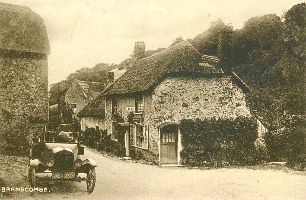
2 27 28 The protected site of Street, huddled under Berry Hill. 27, a pre-world War I view shows much more thatch on the roofs than the later picture, taken from almost the same position. 28 appears to have been taken on a Monday - wash-day.


3 29 Margells Cottage taken about 1910 a cottage dated by Pevsner to the late 16th Century. The donkey s frame would carry baskets (crubs) on each side for early potatoes and other crops grown out on the cliff plats (see also Part 2 38, 39 and50). 30


4 31 One of Street s two shutes for drinking water transported in buckets. The first looks south towards Margells, the second north towards the Fountain Head. 31a

 parked")
5 32 33 Three views of Beehive cottage, across the road from Margells, 31a and 32 are early views, 33 has a 1920s car (TT 6814 a local number) parked outside.
6 34 35a
, the shop has a posh new display case, a new door, some new thatch and smartened up walls.")
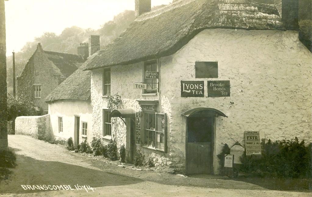
7 35 On the corner opposite Beehive Cottage, and across the road from Margells, was Susan Gill s shop. Comparison of these three cards show that as time went on there was some refurbishment. In the first two cards, pre 1920, the Tea sign is up, but the wall are unrendered. In the third (35), the shop has a posh new display case, a new door, some new thatch and smartened up walls. The Gills were carpenters and they designed and made the model soldiers on the chimney top. The boards by the shop door (34) signify that this was indeed the centre of the universe. The board on the left advertises a monthly meeting of Branscombe Women s Institute. Beer Women s Institute Garden Party, sale of work and fete are listed on the central board. On the right we learn about a fete and sale of work at Seaton Congregational Church on Thursday July 1st but which year? July 1st fell on a Thursday in 1897, 1909, 1915, 1920 and 1929 showing the problem of dating some postcards. That board also lists a concert, sports and a baby show in Seaton quite a lot going on in the area at that time.


8 36 Hub of the Street settlement: the Fountain Head Pub. The sign over the door reads Thomas Gill, Retailer of Ales, Spirits and Tobacco. At this time, Street had a forge and a blacksmith alongside the pub. PART TWO THE CLIFFS, AND BRANSCOMBE MOUTH TO SQUARE The cliffs 37 Looking towards Sidmouth from Littlecombe Shoot. These impressive cliffs west of Branscombe Mouth reveal the key features of the rock

9 types underlying the whole parish. Chapman s photographer has made a long haul across the pebbles for this shot which shows the two main rock formations. New red sandstones and marls form the lower portion of the cliff face. The new red rocks are capped by more recently deposited upper greensand beds which are porous. A spring line divides the two rock types. The gradient on the sandstones and marls is steep, but the photograph shows that the greensand capping towards the top of the cliff has a steeper face. Over the centuries these features have played a significant part in the evolution of settlement and land use in Branscombe and, of course, the scenery depicted on other postcards. Farms, grazing land and settlements were established on the well-watered land below the spring line. At key points in the village the springs were piped into outlets called shutes for public water supplies. Above the spring line the soils on the porous greensand are drier and poorer. Up there farming is more difficult and the steep slopes are often covered with trees and scrubby vegetation. 38

10 39 Views of the south-facing cliff plots or plats between Littlecombe Shoot and Branscombe Mouth. Sited on the platform which runs along between the greensand and the marls lower down, these small cultivated areas were almost immune from frosts. They produced early crops potatoes and flowers etc which were transported by donkeys, because they could cope with the steep slopes. Looking down on the plats at Littlecombe Shoot on a lovely spring morning in May 1858, Peter Orlando Hutchinson, the Sidmouth antiquarian, comments on a beautiful undercliff, a sort of stage, halfway down to the sea well cultivated with corn, potatoes etc. (50 shows cliff-side plats east of Branscombe Mouth soon after 1900.) The plats were at their peak in the late 19th and early 20th Centuries, nowadays most of the plats have grown over. At Littlecombe Shute a few of the stone linhays used to shelter the donkeys and store the potatoes, have been converted into small holiday homes. In postcard 38 the hummocks to the left of the picture are the remains of the old lime workings. Developments at Branscombe Mouth


11 40 41 The Look Out was constructed in the early part of the 19th Century as a coastguard station in response to the smuggling operations that flourished along this stretch of coast in the period from shows the Look Out from the west in the early 1920s. Seaside Farm is on the left. The land between the farm building and the cliff edge later became a major camping ground (see 45 and 46).


12 42 The Look Out and the old stone-walled coalyard about The yard had been used to store imported coal for the local lime industry. In the late 1920s it was transformed by Clem Ford and his wife into the Sea Shanty beach café. This turned out to be a key decision for the future of holidaymaking in Branscombe. 43 An early advert for the Sea Shanty emphasising its distinctive appearance and attractions for visitors the tea rooms and rock gardens.

, plain")
13 44 By 1932 the Sea Shanty was providing meals and services for a growing number of visitors, including walkers and campers. At this time cream teas were 1s/6d (7½p), plain teas a shilling (5p). 45


14 46 47 Camping holidays became popular on the field beside Seaside Farm and on the beach.


15 48 49 Others stayed in chalets by the beach, west (48) and east (49) of Branscombe Mouth. These were set up in the late 20s/early 30s and named after birds. Water was supplied by standpipes along the top of the beach in front of the chalets (48). These chalets did not have main drainage. They were replaced by more modern versions and caravans after 1950.


16 50 Before the chalets and caravans: a 1905 view from the same position as 49. Castle Rock and the 1790 Hooken landslip in the distance. 51


17 52 53 Some interwar diversions for visitors. Just round the corner from the Sea shanty, the waterfall (51), surrounded by exotic plants and ornaments and created by Clem Ford using a water-powered electric generator, was always an attraction.

18 54 55 These messages Branscombe. show varied reactions to the attractions Post 1945 changes at Branscombe Mouth (56-62) of
How can we use census data in the classroom to research past events?
 Find My Past is giving schools in the United Kingdom three months free access to their census and military records Read this Case Study to find out how Key Stage 2 pupils can use census data to research
A unique place to celebrate special occasions with family and friends.
 A unique place to celebrate special occasions with family and friends. The Manor House A truly magical place for a unique holiday, party or special occasion Cadhay has been beautifully restored and offers
Chapter 7 Geography and the Early Settlement of Egypt, Kush, and Canaan
 Chapter 7 Geography and the Early Settlement of Egypt, Kush, and Canaan How did geography affect early settlement in Egypt, Kush, and Canaan? Section 7.1 - Introduction RF/NASA//Corbis This satellite photograph
WALKS AROUND WOODHURST
 WALKS AROUND WOODHURST With Walks To Woodhurst from North St. Ives Woodhurst is situated on the verge of an elevated tract of table land four miles north of St. Ives. Its footpaths vary from leafy lanes
The Buildings of Ailsworth
 Chapter 10 The Buildings of Ailsworth Introduction Today, old and new houses, large and small, stand side by side, the result of the natural growth of the village of Ailsworth. It is now difficult to imagine
Chapter 7. Geography and the Early Settlement of Egypt, Kush, and Canaan
 Chapter 7 Geography and the Early Settlement of Egypt, Kush, and Canaan Chapter 7 Geography and the Early Settlement of Egypt, Kush, and Canaan How did geography affect early in Egypt Kush, and Canaan?
Section 6 WHALE CHINE TO FRESHWATER BAY
 Section 6 WHALE CHINE TO FRESHWATER BAY Introduction The route begins at Whale Chine and follows the Public ROW of the existing coastal footpath to the Lifeboat House at Freshwater Bay. The area is characterised
Morgan s Vale and Woodfalls History Trail. (You could start at any point and follow the trail round)
") Morgan s Vale and Woodfalls History Trail (You could start at any point and follow the trail round) 1) MORGAN S VALE & WOODFALLS PRIMARY SCHOOL Built in 1869, it served as a church on Sundays until the
Morgan s Vale and Woodfalls History Trail (You could start at any point and follow the trail round) 1) MORGAN S VALE & WOODFALLS PRIMARY SCHOOL Built in 1869, it served as a church on Sundays until the
2015 Brain Wrinkles. SS8G1b
 SS8G1b Georgia is a geographically diverse state that is divided into five regions. The first three regions (Appalachian Plateau, Valley and Ridge, and Blue Ridge) are in the mountains and foothills of
Beautiful Walks from the Blue Ball Inn
 Walk No. 2 WINSTONS WALK Countisbury, Wind Hill, Watersmeet, Ash Bridge and Winston s path. 5 Miles approx. Walking time- Two and a half hours approx. (Not including Breaks) OS 1:25,000 Sheet 64/74 Lynton
Ancient Egypt and the Near East
 *O*»f ' i ft Ancient Egypt and the Near East Chapter 7 Chapter 8 Chapter 9 Geography and the Early Settlement of Egypt, Kush, and Canaan The Ancient Egyptian P h a r a o h s Daily Life in Ancient Egypt
Horden. A walk of nature...sea and history
 Horden A walk of nature......sea and history 182 283 A181 Wingate B1287 Peterlee Seaham Easington B1281 Newcastle Horden Blackhall A179 Newcastle International Airport Crimdon A1086 Location... Horden
World History: Patterns of Interaction
 The Americans: A Separate World, 40,000 B.C. A.D. 700 Although early American civilizations remain mysterious, we know that the earliest Americans most likely migrated from Asia and that complex cultures
ID: 283 Distance: 6.2 miles Height gain: 500 Metres Map: Explore OL 19 Contributor David and Chris Stewart
 Walkingworld Wild Boar Fell ID: 283 Distance: 6.2 miles Height gain: 500 Metres Map: Explore OL 19 Contributor David and Chris Stewart Features Birds, Great Views, Hills or Fells Description: Wild Boar
Physical. and. Human-made. Features
 Directions for Making a Geographic Features Vocabulary Book 1. Cut the photographs boxes out of page 2 and sort the them into two groups: physical features and human-made features. 2. Correctly match each
ISOM & ISSOM forbidden symbol comparison
 & forbidden symbol comparison Forbidden symbols and their relatives Symbol 2000 (Long, Middle) 2007 (Sprint) 201 Impassable cliff An impassable cliff, quarry or earth bank (see 106) is shown with a 0.35
The Earliest Americans
 The Earliest Americans A Land Bridge Section The Earliest Americans The cultures of the first Americans, including social organization, develop in ways similar to other early cultures. The American Continents
BISHOPSTONE CIRCULAR WALK
 BISHOPSTONE CIRCULAR WALK 4½ miles (7¼ km) - allow 2 hours (see maps on final pages) Introduction This walk is within the North Wessex Downs Area of Outstanding Natural Beauty and starts from the small,
SS8G1 The student will describe Georgia with regard to physical features and location.
 SS8G1ab Standards SS8G1 The student will describe Georgia with regard to physical features and location. a. Locate Georgia in relation to the region, nation, continent, and hemispheres. b. Describe the
RURAL LAND RESOURCES Case study area 1- the erosional features of the Dorset Coast.
 Case study area 1- the erosional features of the Dorset Coast. Scene setting;- This area lies on the far south coast of England, between the settlements of Lyme Regis and Bournemouth, in the county of
Going Out. Teacher's Background. Time of
 Going Out Teacher's Background Time of When Walthamstow first began to grow, there was little in the way of organised public entertainment. Until the 1860s the only public spaces were churches and chapels,
Boardwalk Orientation Walk
 Copyright by GPSmyCity.com - Page 1 - Boardwalk Orientation Walk Atlantic City is a popular resort, well known for its iconic Boardwalk, numerous fashionable casinos, sandy beaches and wonderful view of
Freehold investment opportunity In the heart of Derby s premier shopping & leisure destination Successful cluster of complimentary retail and leisure
 Freehold investment opportunity In the heart of Derby s premier shopping & leisure destination Successful cluster of complimentary retail and leisure occupiers Fixed rental increases Scope for value enhancement
West Wirral (Dee Estuary)
") View of Hilbre Island from West Kirby with walkers at low tide. West Wirral (Dee Estuary) West Kirby is the start of the 12 mile long Wirral Way, the backbone of Wirral Country Park, the old Hooton to
View of Hilbre Island from West Kirby with walkers at low tide. West Wirral (Dee Estuary) West Kirby is the start of the 12 mile long Wirral Way, the backbone of Wirral Country Park, the old Hooton to
Beautiful Walks from the Blue Ball Inn
 Walk No. 5 RIVER VALLEYS AND MOOR Countisbury, Watersmeet, Hillsford Bridge, Cheriton, Shilstone Hill, Rockford and Chiselcombe. 8.5 MILES APPROX. Walking time four and a half hours approx. OS 1;25,000
RR Program Summary: Historic restoration and rehabilitation of the interior and exterior of a 42-room boutique hotel located in Covington, LA.
 Program Summary: Historic restoration and rehabilitation of the interior and exterior of a 42-room boutique hotel located in Covington, LA. Program Statement: Originally constructed in 1907, the hotel
Royal Oak Farm 8PP.qxp_Stags 11/10/ :01 Page 1 Royal Oak Farm
 Royal Oak Farm 8PP.qxp_Stags 11/10/2018 17:01 Page 1 Royal Oak Farm Royal Oak Farm 8PP.qxp_Stags 11/10/2018 17:01 Page 2 Royal Oak Farm Cotleigh, Honiton, Devon EX14 9LF Honiton 4 miles Lyme Regis 12 miles
POSIO. Welcome to Posio, the magic land of Lapland.
 POSIO Embrace the forest changing by the season, experience the overwhelming sound of silence, enjoy heart-warming hospitality and get lost in mythical stories. Welcome to Posio, the magic land of Lapland.
2015 Brain Wrinkles. SS8G1b
 SS8G1b Standards SS8G1 The student will describe Georgia with regard to physical features and location. b. Describe the five geographic regions of Georgia; include the Blue Ridge Mountains, Valley and
Kuruwita Erathna Trail to Sri Pada (Adam s Peak)
") Kuruwita Erathna Trail to Sri Pada (Adam s Peak) Trail Difficulty: Easy Moderate Strenuous Tough Trail Head: Adevikanda, Erathna (near entrance to mini-hydro power plant) Nearest Town: Erathna Nearest
Kuruwita Erathna Trail to Sri Pada (Adam s Peak) Trail Difficulty: Easy Moderate Strenuous Tough Trail Head: Adevikanda, Erathna (near entrance to mini-hydro power plant) Nearest Town: Erathna Nearest
August - October 2016 Magazine
 Editor: Edwin Lilly Issue 13 Email: edwin _lilly@yahoo.co.uk August - October 2016 Magazine Welcome to the August October 2016 edition of our Magazine. This issue runs from 1st August to 31st October.
ANGEL PEAK SCENIC AREA
 Activities: Facilities: ANGEL PEAK SCENIC AREA Hiking, photography, watchable wildlife, camping, picnicking. Note: While formal hiking trails in the area are limited, dispersed hiking opportunities abound
Unit 1: Physical Environment Glaciated Landscapes
 Unit 1: Physical Environment Glaciated Landscapes Corries Corries are bowl-shaped hollows high up in the mountains. They are formed in the following way: Snow collects in a hollow on a mountainside (usually
3rd GRADE MINIMUM CONTENTS UDI 1: LANDSCAPES (5)
") 3rd GRADE MINIMUM CONTENTS UDI 1: LANDSCAPES (5) DIFFERENT LANDSCAPES A landscape is all the things that we see in a place. There are different types of landscapes. Mountain landscapes have mountains and
3rd GRADE MINIMUM CONTENTS UDI 1: LANDSCAPES (5) DIFFERENT LANDSCAPES A landscape is all the things that we see in a place. There are different types of landscapes. Mountain landscapes have mountains and
2. What activities do you and others in your household do in the Negril Marine Park and along its coast for work or fun?
 Socio-economic Monitoring by Caribbean Fishery Authorities Individual and Household Survey for Negril Marine Park (edited for training purposes) This survey is being done by the non-governmental organization
Information and Timetable A Manx Registered Charity operated entirely by volunteers.
 2015 Information and Timetable A Manx Registered Charity operated entirely by volunteers. 2015 Timetable Calendar codes GREEN 11am to 4:30pm RED Wednesdays 7-9pm BLUE SPECIAL EVENTS 11am to 4:30pm (unless
MILL HILL West Sussex
 MILL HILL West Sussex from www.discoverbutterflies.com the website for the book Discover Butterflies in Britain D E Newland Shoreham Bank, the south-western slope of Mill Hill, looking north in August
Learning Places Spring 2016 LIBRARY / ARCHIVE REPORT #1 Brooklyn Public Library. Carlos Merced INTRODUCTION PRE-VISIT REFLECTION
 Learning Places Spring 2016 LIBRARY / ARCHIVE REPORT #1 Brooklyn Public Library Carlos Merced 02.29.2015 INTRODUCTION The Brooklyn Public Library has thousands of public programs, extensive book collections,and
Discover. Take a seat in the front row, watching the theatre of mother nature unfold. IGUAZÚ ENJOY THE EXPERIENCE
 Discover IGUAZÚ ENJOY THE EXPERIENCE Take a seat in the front row, watching the theatre of mother nature unfold. ARGENTINA, SOUTH AMERICA Iguazú WELCOME Please don t forget to bring the following items
Norham Station. Norham, Berwick upon Tweed
 Norham Station Norham, Berwick upon Tweed Norham Station Norham, Berwick upon Tweed, TD15 2LW DELIGHTFUL HISTORIC TUDOR STYLE RAILWAY STATION WITH STATION MASTER S HOUSE Station Master s House 2 Reception
COME & enjoy THE. Trans Pennine Trail. Penistone-Dunford Bridge. Trans Pennine Trail conservation volunteers Penistone Dunford Bridge
 COME & enjoy THE Penistone-Dunford conservation volunteers Penistone Dunford Welcome to your! Running between the lively market town of Penistone, and the lower slopes of the Peak District at Dunford,
landcapes and romance Artists and poets have been inspired by the idyllic scenes of picturesque Kent villages sheltered by rolling, chalk hills.
 landcapes and romance Artists and poets have been inspired by the idyllic scenes of picturesque Kent villages sheltered by rolling, chalk hills. WALK 4 41 41 WALK 4 42 Pond Location: Distance: 5 miles
DAY 1: Emu Plains to Glenbrook Wednesday, January 2, 2019
 DAY 1: Emu Plains to Glenbrook Wednesday, January 2, 2019 Some sun: 34 C / 21 C 3mm Meeting time: 8.00am @ Our Lady of the Way Catholic Church, Emu Plains [15 Troy Street, Emu Plains; altitude: 32m] Mass:
Department of Tourism, Culture and Recreation Provincial Archaeology Office 2012 Archaeology Review February 2013 Volume 11
 Department of Tourism, Culture and Recreation Provincial Archaeology Office 2012 Archaeology Review February 2013 Volume 11 Area 14 of FjCa-14 in Sheshatshiu, portion of feature in southeast corner of
Information and Timetable A Manx Registered Charity operated entirely by volunteers.
 2014 Information and Timetable www.ggr.org.uk A Manx Registered Charity operated entirely by volunteers. 2014 Timetable Calendar codes GREEN 11am to 4:30pm RED 7pm to 9pm BLUE SPECIAL EVENTS 11am to 4:30pm
Byelorussian Battlefields
 Byelorussian Battlefields All Flames Of War battles need terrain! Battles in the Second World War were rarely fought over open plains with unobstructed lines of sight. In Flames Of War, wide open tables
SURVEY OF PUBLIC HOUSES WESTON TURVILLE
 BUCKINGHAMSHIRE ARCHAEOLOGICAL SOCIETY HISTORIC BUILDINGS GROUP SURVEY OF PUBLIC HOUSES IN THE PARISH OF WESTON TURVILLE BUCKINGHAMSHIRE A record of extant buildings that are currently or were formerly
Ropewalks Liverpool. Funky and affordable office, leisure and retail space, units from 85 to 10,000 sq ft
 Ropewalks Funky and affordable office, leisure and retail space, units from 85 to 10,000 sq ft Ropewalks Historically the Ropewalks area was the home of rope making for sailing in the 19th Century. Ropewalks
Local Green Spaces Study
 Nuthurst Parish Council Neighbourhood Plan Local Green Spaces Study October 2014 Page 1 of 5 Produced by the Nuthurst Parish Neighbourhood Plan Steering Committee Local Green Spaces in Nuthurst Parish
Minehead Seafront Refurbishment Survey Analysis
 Minehead Seafront Refurbishment Survey Analysis Survey Returns: From Online Survey Monkey site Respondents: 143 https://www.surveymonkey.com/results/sm-jy7lq58ll/ From Online Survey Monkey site Respondents:
Walk 1: Highfield, Lob Wood and The River Wharfe
 Walk 1: Highfield, Lob Wood and The River Wharfe Start: The Hen Pen Garden, Main Street, Addingham LS29 0NS, SE 077 498. Alternative Start: Near Bolton Bridge SE 071 525 (see page 6). Full walk: 4.5 miles
GEOGRAPHY AND HISTORY
 GEOGRAPHY AND HISTORY YEAR 1, PART 1 www.vicensvives.es Contents 01 Our planet Earth 02 The representation of the Earth: maps 03 The Earth s relief 04 Rivers and seas 05 Weather and climate 06 Climates
Crimdon. A walk of nature...sea, sand and countryside
 Crimdon A walk of nature......sea, sand and countryside A182 B1283 A181 Wingate B1287 Peterlee Seaham Easington B1281 Newcastle Horden Blackhall A179 Newcastle International Airport Crimdon A1086 Location...
EXPLORE KLARÄLVSDELTAT BY BIKE
 EXPLORE KLARÄLVSDELTAT BY BIKE EXPLORE NATURE BY BIKE THE BIKE TRAIL 1. Stadsträdgården (City garden) park was laid out in 1861 and there was a restaurant here from 1870 to 1959. In the northwest corner
Orchards and oasts a taste of the Garden of England
 49 Orchards and oasts a taste of the Garden of England Open parkland, orchards, oasts and incredible panoramic views over the Weald to the South Downs make this a truly memorable walk. Linton Village 50
Sponsorship and Partnership Opportunities 2018 #LTA18
 Sponsorship and Partnership Opportunities 2018 Celebrating Tourism Excellence in Lancashire s 4.1 Billion visitor economy Welcome This will be my first Lancashire Tourism Awards as Chief Executive and
TOUR TO SHETLAND 8 TH - 12 TH OCTOBER 2018
 TOUR TO SHETLAND 8 TH - 12 TH OCTOBER 2018 The Shetland Islands are an archipelago over 100 miles north of the tip of Scotland with a history which can be traced back to 2000 years BC. The islands, once
HIKING IN THE CANADIAN ROCKIES
 HIKING IN THE CANADIAN ROCKIES Distance Time Elevation y MORAINE LAKE TRAILS THE ROCKPILE 0.8 km (0.5 mi) 20 min 30 m (98 ft) Located adjacent to the Lodge, the short interpretive trail up the Rock Pile
middle left: Riversleigh fossils lower left: Constance Range images: Hj Preuss... Thx
 Upstreampaddle Summer 2008 18 middle left: Riversleigh fossils lower left: Constance Range images: Hj Preuss... Thx top right: road west of the Isa middle right: Constance Range lower right: rocky outcrop
POSTCARDS AND OLD PHOTOS OF THE PARK ERA, The Midway
 POSTCARDS AND OLD PHOTOS OF THE PARK ERA, 1885-1911 The majority of these photographs appear to have been taken during the latter period of the park, circa 1905 to 1911. The Midway A lovely afternoon at
Student Reading 13.10: The Regions of Ohio
 Student Reading 13.10: The Regions of Ohio Ohio has five natural regions which formed more than 10,000 years ago. A natural region is an area that shares the same natural features. These places have similar
Little Grand Canyon near Pomona, Illinois
 Little Grand Canyon near Pomona, Illinois Below: View of the trail and the terrain created using the Map My Hike app Below: Summary of the hike created using the Map My Hike app Presented by: Jennifer
Retail Vacancy Survey Abingdon, Faringdon and Wantage
 Retail Vacancy Survey 2015 Abingdon, Faringdon and Wantage Introduction The retail vacancy rate across the Vale of White Horse District Council s market towns of Abingdon, Faringdon and Wantage as of September
Best Hikes on Orcas Island
 Published on San Juan Islands Washington Visitors Bureau Orcas Island Lopez Island Friday Harbor San Juan Island (https://www.visitsanjuans.com) Best Hikes on Orcas Island The Emerald Isle offers big trees,
Wicklow Mountains Path Survey
 Wicklow Mountains Path Survey Glenmacnass Tonelagee Start to Finish: O 114 030 to O 085 016 Altitude (lowest highest): 370m 817m Weather: Sunny day, hot Access: Military Road, Glenmacnass Surveyed by:
Specification for Grip blocking using Peat Dams
 Technical Guidance Note 1 Specification for Grip blocking using Peat Dams 1. Introduction Moorland drains (grips) have been dug across much of the Yorkshire upland peatlands. Many of these grips have become
48 ALBERT STREET ROYAL ALBERT HOTEL
 48 ALBERT STREET ROYAL ALBERT HOTEL HISTORICAL BUILDINGS COMMITTEE 12 December, 1980 48 ALBERT STREET Royal Albert Hotel This hotel has an elusive history shaped by factors of time and place. It was never
Adventure Travel Trip Itinerary
 Adventure Travel Trip Itinerary Mt. Kilimanjaro & Mt. Meru Climbs, Tanzania July 8 23, 2017 Leader: Bill Blazek Date Activity (distances are approximate) Accommodation, Notes Meals 1 Saturday July 8, 2017
1. Study the Ordnance Survey Map of Brodick, Isle of Arran.
 1. Study the Ordnance Survey Map of Brodick, Isle of Arran. To find the map go to: > http://www.bing.com/maps/ > change maps type to Ordnance Survey Map from Road. > search for Glenrosa Water (it is near
Ferryhill a short history
 Ferryhill a short history by Jane Hatcher General Background History The place name has nothing to do with ferries! It comes from the Old English word fergen or hill, and means a settlement on a hill (1).
TREK THE ROCKIES ABOUT THE CHALLENGE TREK THE ROCKIES FOR HIGHLAND HOSPICE CANADA TREK DEMANDING
 TREK THE ROCKIES CANADA TREK DEMANDING ABOUT THE CHALLENGE The Canadian Rockies are justifiably world-famous for their magnificent scenery: the combination of impressive, jagged mountains, bright turquoise
SOEC Field Studies Programmes Examples at Belmont Centre
 SOEC Field Studies Programmes Examples at Belmont Centre Belmont Centre is ideally located for intensive, Geography field studies trips. Whether it s a study on sand dune succession or fluvial processes
Brisbane to Toowoomba Historical Weekend
 Brisbane to Toowoomba Historical Weekend Take a drive back into the past with this historical weekend drive, from Brisbane to Toowoomba, through the charming town of Ipswich Brisbane to Toowoomba Historical
trek Namibia actionchallenge in Namibia at a glance trip highlights
 actionchallenge in A fascinating ten day challenge including five days trekking through spectacular desert landscape, which gives a fabulous chance to explore s history, culture and nature. Our trek begins
Hiking Distances& Terrain
 The section of the Wild Coast from Port St John s (PSJ) in the north to Coffee Bay in the south forms part of the original Transkei Hiking Trail and is approximately 66km long. It covers some of the best
INTERNATIONAL CLIMS CAMP JULY, 2018 WAPLEWO POLAND
 INTERNATIONAL CLIMS CAMP 2018 15 29 JULY, 2018 MEMORANDUM Memorandum of Understanding concerning the organization and conduction of the International CLIMS Camp : Encourage young people to find out about,
King George Area: May 5-18, 2019
 King George Area: May 5-18, 2019 Section 1: Faraway Bay airstrip to Twin Falls: May 5-12 We fly to the Faraway Bay airstrip where we leave the food for the second section, don our packs and head toward
NORTON ST PHILIP PARISH COUNCIL
 NORTON ST PHILIP PARISH COUNCIL www.nortonstphilipparishcouncil.co.uk Chair Clive Abbott, Hassage House, Faulkland, Radstock, BA3 5XG ncliveabbott@hotmail.com Clerk Nicola Duke, 6 Shetland Close, Westbury,
INTERNATIONAL CLIMS CAMP JULY, 2018 WAPLEWO POLAND
 INTERNATIONAL CLIMS CAMP 2018 15 29 JULY, 2018 AGENDA MEMORANDUM ABOUT THE CAMP S STRUCTURE OTHER INFORMATIONS ACCOMMODATION FACILITY MEALS SPORT AND RECREATION MAIN SPORTS AND LEISURE ACTIVITIES MAIN
Chapter 7: The Geography and Settlement of Egypt, Kush, and Canaan
 Chapter 7: The Geography and Settlement of Egypt, Kush, and Canaan Learning Target: I can explain how geography affected early settlement in Egypt, Kush, and Canaan. Ancient Egypt and the Middle East Can
WALK 2 Eynsford. soar with the birds. Enjoy a bird s eye view. Eynsford Viaduct
 soar with the birds Enjoy a bird s eye view WALK 2 Eynsford 29 Eynsford Viaduct 30 30 Crown copyright 100019238. Eynsford Lullingstone Roman Villa Location: Eynsford Distance: 1.8 miles (2.9km) Time: allow
ISOLA ROSSA SITE NOTABLE FEATURES. The Aragonese Tower
 ISOLA ROSSA SITE Isola Rossa is located in Gallura, in the municipal territory of Trinità D Agultu and Aglientu which stretches on the Asinara Gulf for 32 km, from Isola Rossa to Cala Serraina, and towards
Ambleside & Windermere Outdoor Properties Access Statement.
 Ambleside & Windermere Outdoor Properties Access Statement. Windermere, Cumbria. T: 015394 46402 E: ambleside@nationaltrust.org.uk please state that your email relates to access in Ambleside or Windermere.
Realities of Poverty: Thatch, tin and timber
 Realities of Poverty: Thatch, tin and timber fall 2017 P overty looks different across regions, nations, cities and the countryside. One family s greatest struggle might be their home or transportation,
American Conservation Experience
 ACE Project Report For Tonto National Forest, Arizona Trail Association and Arizona State Parks Title of Project: 4 Peaks Trail Maintenance Award Contract Number: ASP NM11021 Project Partner: Paul Burghard
Friends Meeting House, Pickering. 19 Castlegate, Pickering, YO18 7AX. National Grid Reference: SE Statement of Significance
 Friends Meeting House, Pickering 19 Castlegate, Pickering, YO18 7AX National Grid Reference: SE 79795 84336 Statement of Significance The meeting house was built in 1793; the attached burial ground was
Baggy Point, Croyde, North Devon
 Baggy Point, Croyde, North Devon A walk using the South West Coast Path that is likely to be suitable for people with impaired mobility or with a pushchair, wheelchair, or mobility scooter. The Coast Path
Skipton Castle Woods Accessibility Statement November 2016
 Skipton Castle Woods Accessibility Statement November 2016 Purpose: This accessibility statement outlines the available facilities and access information for Skipton Castle Woods. Welcome We, the Woodland
Western Commission Track to Dubbo Gully
 This two day walk follows a series of historic roads along clear and wide management trails. This walk explores the great views from Western Commission Track, the sandstone handicraft on the Old Great
Clayfaulds Farm, Bonnybridge, Stirlingshire, FK4 2HA. Offers over 450,000
 Clayfaulds Farm, Bonnybridge, Stirlingshire, FK4 2HA Offers over 450,000 Particulars of Sale Junction 6A M80 2 miles, Bonnybridge 2.5 miles, Denny 4 miles, Falkirk 6 miles, Cumbernauld 7 miles, Stirling
PHYSICAL GEOGRAPHY GEOGRAPHY EARTH SYSTEMS COASTAL SYSTEMS FLUVIAL SYSTEMS
 PHYSICAL GEOGRAPHY EARTH SYSTEMS FLUVIAL SYSTEMS COASTAL SYSTEMS PHYSICAL GEOGRAPHY CORRIES / CIRQUES A Corrie or Cirque is the armchair shaped hollow that was the birthplace of a glacier. It has steep,
Inca Trail Expedition. $ 785 USD per person 5D/4N
 Inca Trail Expedition $ 785 USD per person 5D/4N Day 1: Cusco Ollantaytambo KM 82 Hatunchaca We will depart from Cusco at 5 a.m. in a private transport and head toward KM 82, the starting point of the
Enford Bridge. We also used to walk along the top rail!!
 Enford Bridge The old Cast Iron bridge over the river Avon in the photo right was a 3 span bridge made by Tasker & Fowle of Andover and built in 1844.There were two brick pillars built in the river and
L U N C H C R E E K T R A I L GLACIER NATIONAL PARK
 D I R T I N M Y S H O E S L U N C H C R E E K T R A I L GLACIER NATIONAL PARK Lunch Creek "Secret" Hike This short hike on the Lunch Creek Trail will knock your socks off! It's the perfect mix of length,
Three mills were situated along the Loddon Valley.
 EASTROP PARK The History of Eastrop Park Eastrop dates back to Roman times, when this lush valley would have been used to grow crops, graze cattle and water horses. It was during the Saxon times, that
MP : The Big Chief Overlook and the Glen
 MP 253 254: The Big Chief Overlook and the Glen The mile between MP 253 and 254 has lots of history in it. It includes the only recorded remains of the Victory Highway on the Clear Creek County side of
National Allotment Society. Newsletter
 National Allotment Society East Midlands Regional Representative Newsletter Association Secretaries: Please forward to your Society members and display on site Notice board JANUARY 2015 VOLUME 2, NUMBER
(west) onto Charleston Boulevard. Drive 16 miles on Charleston and turn right into Red Rock
 onto Charleston Boulevard. Drive 16 miles on Charleston and turn right into Red Rock") Hike: North Peak and Ice Box Overlook up and back Trailhead: 2.5 miles up the Rocky Gap Road not mark Distance: 5 miles round trip Elevation gain: 2,694 feet Elevation Peak: 7,094 feet Time: 3 to 5 hours
Hike: North Peak and Ice Box Overlook up and back Trailhead: 2.5 miles up the Rocky Gap Road not mark Distance: 5 miles round trip Elevation gain: 2,694 feet Elevation Peak: 7,094 feet Time: 3 to 5 hours
Pontfadog. Walk A. Walk A
 Walk A A Bird s eye view of the village 2km. (1 1 /2 miles); height gain 45m. (150ft) about 45 minutes. Six minutes walk along the main road towards Glyn Ceiriog reach a signpost to Llwynmawr. Take the
Lavenham Guildhall Access Statement
 Lavenham Guildhall Access Statement The Guildhall of Corpus Christi, Market Place, Lavenham Suffolk CO10 9QZ T: 01787 247646 E: lavenhamguildhall@nationaltrust.org.uk Introduction The Guildhall is an early