EXPLORE KLARÄLVSDELTAT BY BIKE
|
|
|
- Timothy Reynolds
- 5 years ago
- Views:
Transcription


1 EXPLORE KLARÄLVSDELTAT BY BIKE EXPLORE NATURE BY BIKE
 Naturum Värmland.")


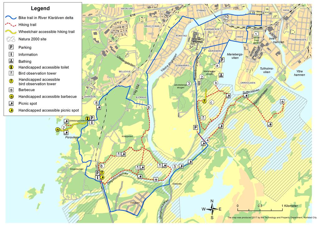
2 THE BIKE TRAIL 1. Stadsträdgården (City garden) park was laid out in 1861 and there was a restaurant here from 1870 to In the northwest corner is the old hothouse, which was both greenhouse and home for the park manager. Naturum Värmland b) Naturum Värmland. This natural history museum provides activity and learning in an interesting mix of fine architecture, lake, river and forest. Stadsträdgården city park Around 800 species grow today in the park and the aim is to always have something in bloom, even in winter. Cycling is forbidden in the park, but a walk among the exotic flowers is recommended. 2. Mariebergsskogen has been Karlstad s open-air museum since On the site are historic buildings, a mini zoo, a new garden playground, the Naturum Värmland natural history museum, a café and some amid pleasant woodland. Cycling is forbidden within the gates, but you can enter on foot via the main entrance (2a) or from Rosenborgsgatan (2d). Marieberg s water-meadows c) From the bird-watching tower you can look out across Marieberg s water-meadows. Cows graze here throughout the summer, which restricts plant and bush growth and thus creates the conditions for a rich variety of bird life. There are several geographical features typical of a delta region, including river furrows, levees and lagoon. A 3 km path crosses the meadows.
3

4 3. Jakobsbergsskogen forest is a popular rambling area. The groundrock here is hyperite, which is rich in lime and therefore good for rich vegetation. Oak and hazel trees are plentiful. The woods here are classified as a key biotope, i.e. an area of special natural value. Forestry is not permitted here. 4. Jakobsbergsbron bridge was the first link between the island of Hammarö and the main land. From the bridge, you can see natural embankments along the northern shore of the river. Embankments often form along the inner curve of a river furrow as the water wears away material from the opposite shore. From here there is a hiking trail that goes to Bergholmen and a view of the open water of Vänern. 5. The Klarälven delta is the largest active delta in Sweden below the mountain line. Being active means that sand carried by the river collects continuously in the outer reaches of the delta, which means continuous new shore formations. The delta landscape is a unique mix of river forks, pasture, reed areas, marsh and woodland swamp, plus various geological features such as river embankments, levees, middle banks and lagoons. There is a wealth of bird and insect life in the deciduous forests next to the water and if you are out at down or sunset you have a fair chance of spotting a beaver. The Klarälven delta has been designated as a Natura 2000 site, which means it is part of an EU network of protected areas. 5 a) Rest area and fishing jetty. The ferry between Karlstad and Hammarö operated from here between 1820 and Birdwatching tower at Knappstadviken 6. Around Knappstadviken there is a 4.5 km long hiking trail with several birdwatching towers. Here too, cows graze the water meadows. The bay is bordered with deciduous forest with a rich plant and animal life. The trail passes through a large variety of natural environments. 7. Göteborgsudden is an unspoilt headland with fine views across Lake Vänern. There is a rocky shore and an old forest. The patch is accessible by wheelchair. There is a picnic table and barbecue pit. Cycling is permitted on the headland. 8. Zakrisdal water-meadows has been opened up again by felling trees and

, the shore at Björkås was a spot where the owners sorted their timber. Equipment was stored here during winter.")
5 cutting back the reeds. The cows work as conservationists and keep the vegetation under control in summer. Dingelsundet. There are places to stop and rest by the water and perhaps try your luck with a fishing rod. 9. Björkås/Klarälven. There are traces here of the log-floating operation on Klarälven. The pillars in the water were used to guide the logs to one side of the river. When logs were floated down the river from Lake Lusten (until 1982), the shore at Björkås was a spot where the owners sorted their timber. Equipment was stored here during winter. Log floatingon Klarälven ended in Älvgatan avenue is considered to be the first official plantation in Karlstad. The decision to plant the avenue was taken in the 1790s. It is believed that some of the horse-chestnut trees date from then. In addition to its impressive age, this avenue is perhaps the most beautiful in Karlstad. Göteborgsudden The trip starts from the main square and is around 15 km long. Most of the time it follows established cycle paths and minor roads. THE TOUR This bicycle tour around the River Klarälven delta provides an opportunity to see a lot of water. The trip passes the wetlands around Mariebergss watermeadows, crosses several delta channels and leads out to an undisturbed rocky bay on lake Vänern. You cycle along pleasant gravel roads through the farming landscape of FACTS Trails: Several trails in the area Level: Easy/Moderate Barbecue sites: Yes Picnic tables: Yes Windshield: No Observetion tower: Yes Information boards: Yes Reachable by bus: Yes Latrines: No Parking: Yes
6 THE RIGHT OF PUBLIC ACCESS In Sweden we have a wonderful opportunity to experience nature and pursue many different activities thanks to our right to public access. When you use your right of public access, it is good to keep some things in mind: The right of public access entitles you to reside in nature as long as you do not disturb animals och plants and respect nature. You must take responsibility for nature and not damage. Remember that crops, replanted forest or other vunerable land should not be damages. Dogs are not allowed to run around unleashed from March 1 to August 20 due to the sensitive peroiod for wildlife. You are free to pick flowers, berries, mushrooms, twigs and branches from the ground as long as they are not sacred. Do not take twigs, branches and bark from growing trees. Please use available barbecue sites and fireplaces when starting a fire. Do not start a fire if there is the least risk of it spreading. If the weather is dry, the lighting of fires is often prohibited. Please take rubbish with you and don t leave glass, tins, plastic bags and bottle caps in nature. You may pinch a tent and camp in the countryside. Please make sure you are in a spot where farming is not carried on and not too close to a residence. Juni Front picture: Shutterstock.com TERRAIN VEHICLES LAW There is no right of public access for motorised vechicles. According to Terrain vehicles law it is forbidden to drive cars, motorcycles, mopeds and other motorised vehicles in the terrain. It it also prohibited to dive any motorised vehicle on any trails or in the woods. Karlstads kommun, teknik- och fastighetsförvaltningen, Karlstad E-post: karlstadskommun@karlstad.se. Telefon:
JÄVERÖN LOVELY ISLAND IN KARLSTAD S ARCHIPELAGO
 JÄVERÖN LOVELY ISLAND IN KARLSTAD S ARCHIPELAGO JÄVERÖN Jäverön is an island in lake Vänern. It covers around 900 hectares and is located around 10 kilometers east of Karlstad. Most of the island is covered
BIKE TRAIL LAKE ALSTERN
 BIKE TRAIL LAKE ALSTERN EXPLORE NATURE BY BIKE THE BIKE TRAIL 1. The poet, Gustaf Fröding, was born at Alster manor in 1860. Today the manor houses an exhibition about the poet s life and a café that serves
Common Sense and the Right of Public Access
 Edition 2: May 2004 ENGLISH Common Sense and the Right of Public Access Photo: Johnér/Hans Bonnevier Do not disturb, do not destroy that is the basic principle of Sweden s right of public access. It is
BIKE TRAIL KROPPKÄRRSSJÖN AND VÄLSVIKEN
 BIKE TRAIL KROPPKÄRRSSJÖN AND VÄLSVIKEN BIKING IN BEAUTIFUL NATURE BICYCLE TOUR KROPPKÄRRSSJÖN-VÄLSVIKEN The bicycle tour around Lake Kroppkärrssjön and Välsviken Bay passes through parks, lake shores
Right of public access paddling
 Right of public access paddling Don t disturb don t destroy The right of public access is a fantastic opportunity for all of us to roam freely in nature. This right applies both on land and water. You
Passport Name: Passport No:
 Passport Name: Passport No: Introduction to the challenge Hi! I m Síolta the Squirrel and I d like to welcome you to the Carlow Family Explorer Challenge. We want to encourage you to get out and explore
This Passport: Revised October 20, 2017, EAM # Discovering the Trails of Penfield, NY
 This Passport: Revised October 20, 2017, EAM #161922 Discovering the Trails of Penfield, NY The Town of Penfield is fortunate to have a wide variety of natural resources which make for many unique and
Silver-washed Fritillaries in the Straits Inclosure in July
 ALICE HOLT FOREST Hampshire from www.discoverbutterflies.com the website for the book Discover Butterflies in Britain D E Newland Silver-washed Fritillaries in the Straits Inclosure in July Alice Holt
The Chilterns Conservation Board The Lodge Station Road Chinnor Oxon OX39 4HA
 The Chilterns Conservation Board The Lodge Station Road Chinnor Oxon OX39 4HA Tel: 01844 355500 Fax: 01844 355501 E Mail: office@chilternsaonb.org www.chilternsaonb.org PRESS RELEASE Chilterns Commons
Location: 7km west of Invercargill on Dunns Road
 SANDY POINT DOMAIN Sandy Point Domain offers the Invercargill community important environmental and recreational resources providing opportunities for picnicking, play, walking, biking, running and as
CRAZY HORSE TRAIL GUIDE
 CRAZY HORSE TRAIL GUIDE Abridged Version: July 2016 This is a short form of our interpretive trail guide for the Crazy Horse Trail. The full version of the guide has a more detailed description of the
AMERICAN S PARTICIPATION IN OUTDOOR RECREATION: Results From NSRE 2000 (With weighted data) (Round 1)
 (Round 1)") AMERICAN S PARTICIPATION IN OUTDOOR RECREATION: Results From NSRE 2000 (With weighted data) (Round 1) The emphasis of this report is on participation patterns across activities and segments of our society.
AMERICAN S PARTICIPATION IN OUTDOOR RECREATION: Results From NSRE 2000 (With weighted data) (Round 1) The emphasis of this report is on participation patterns across activities and segments of our society.
KETTLE CREEK CONSERVATION AUTHORITY TRAIL GUIDE.
 KETTLE CREEK CONSERVATION AUTHORITY TRAIL GUIDE www.kettlecreekconservation.on.ca EXPLORE OUR TRAILS HIKE OUR TRAILS Kettle Creek Conservation Authority (KCCA) proudly supports and promotes an active lifestyle
Stephens State Park Trails
 TRAILS OF ALLAMUCHY MOUNTAIN & STEPHENS STATE PARKS Allamuchy Mountain and Stephens State Parks contain 28 marked trails providing access to diverse landscapes for walking, hiking, biking, bird-watching,
Seager Wheeler Lake. Representative Area. -- Concept Management Plan --
 Seager Wheeler Lake Representative Area -- Concept Management Plan -- Saskatchewan Environment and Resource Management January, 1999 Saskatchewan s Representative Areas Network Program The Government of
Signage at. Kullaberg. Laura Kate Parsons Landscape architect. Lasse Bruun Eriksen Building architect
 Signage at Kullaberg Laura Kate Parsons Landscape architect Lasse Bruun Eriksen Building architect Project task A new signage proposal for the entrance and main parking lot of the western part of Kullaberg
Marchand Provincial Park. Management Plan
 Marchand Provincial Park Management Plan 2 Marchand Provincial Park Table of Contents 1. Introduction... 3 2. Park History... 3 3. Park Attributes... 4 3.1 Natural... 4 3.2 Recreational... 4 3.3 Additional
 VAN BUREN POINT INFORMATION GUIDE 2016 www.vanburenpoint.org/ Van Buren Point is a special community maintained with funds from cottage owners. As such, we have a special responsibility to ensure and protect
Available. 1.5 hrs $90(R)/$120(N) Spring & Autumn. Mon Fri Afterschool. Saturday 10 am or 1 pm. Autumn. Fri & Sat only
/$120(N) Spring & Autumn. Mon Fri Afterschool. Saturday 10 am or 1 pm. Autumn. Fri & Sat only") Fall 2017 Cub Scout Badge s, Knoch Knolls Nature Center, 320 Knoch Knolls Rd., Naperville, IL 60565 To book a program: Contact Nature Center Staff, 630-864-3965 or info@napervilleparks.org Tiger Cub s
Fall 2017 Cub Scout Badge s, Knoch Knolls Nature Center, 320 Knoch Knolls Rd., Naperville, IL 60565 To book a program: Contact Nature Center Staff, 630-864-3965 or info@napervilleparks.org Tiger Cub s
Our Murray River Beaches
 Page 1 of 5 Our Murray River Beaches Click here to print this page West of Yarrawonga are many access points to the river. Earth tracks lead from the Murray Valley Highway through state forests to picnic
Understanding user expectations And planning for long term sustainability 1
 Understanding user expectations And planning for long term sustainability 1 What is a natural surface trail? It can be as simple has a mineral soil, mulched or graveled pathway, or as developed as elevated
Discover. Ashhurst Domain. Nature s Playground
 Discover Ashhurst Domain Nature s Playground Discover Step back into New Zealand, Aotearoa, of generations long gone. Discover lush natural surrounds echoing with rich birdsong in one of the Manawatu s
Center of Youth Voluntary Activities
 Center of Youth Voluntary Activities Lithuania The organization was established in 1988 as a union of several student clubs. Deineta is an independent non-political voluntary service organization. We organize
Water safety box leader s notes page 1
 Water safety box leader s notes page 1 How to use these notes These notes provide you with ideas for using the contents of the water safety box with small groups of children. You can use all or some of
Lewis and Clark Recreation Area
 Lewis and Clark Recreation Area Bicycle/Pedestrian Trail Also part of the Pierson Ranch Recreation Area trail Type of trail: Walking, biking and rollerblading Trail surface: Asphalt Rated: Mostly flat.
Camping (Primitive) Camping (RV) Electrical Potable Water Grill Established Fire Pit Picnic Table
 Camping (RV) Electrical Potable Water Grill Established Fire Pit Picnic Table") Alden - 9th Road River Mile 777 Map: 38.20833, -98.32031 Managing Agency: Kansas Department of Wildlife, Parks & Tourism Nearest Community: Alden, Rice County Kansas Developed Amenities Provided Parking
Alden - 9th Road River Mile 777 Map: 38.20833, -98.32031 Managing Agency: Kansas Department of Wildlife, Parks & Tourism Nearest Community: Alden, Rice County Kansas Developed Amenities Provided Parking
Trail Etiquette. Hours of Operation. Trail Accessibility
 Trail Guide The Elmhurst Park District, with 28 parks and over 460 acres of land, offers nearly six miles of paved or asphalt park trails and maintains an additional 3.6 miles of trails within Elmhurst.
MIA - Lake Mälaren Inner Archipelago - Restoration and Management LIFE07 NAT/S/000902
 MIA - Lake Mälaren Inner Archipelago - Restoration and Management LIFE07 NAT/S/000902 Project description Environmental issues Beneficiaries Administrative data Read more Contact details: Project Manager:
Aapa Mire Wilderness Life
 Aapa Mire Wilderness Life to protect species - southernmost aapa mire wilderness areas in Northern Ostrobothnia and Kainuu to protect peatland ecology Final report 2005 in Europe LIFE Nature project supported
Discover. Take a seat in the front row, watching the theatre of mother nature unfold. IGUAZÚ ENJOY THE EXPERIENCE
 Discover IGUAZÚ ENJOY THE EXPERIENCE Take a seat in the front row, watching the theatre of mother nature unfold. ARGENTINA, SOUTH AMERICA Iguazú WELCOME Please don t forget to bring the following items
ANGEL PEAK SCENIC AREA
 Activities: Facilities: ANGEL PEAK SCENIC AREA Hiking, photography, watchable wildlife, camping, picnicking. Note: While formal hiking trails in the area are limited, dispersed hiking opportunities abound
CUB SCOUT PACK 4034 HIKING STICK PROGRAM
 CUB SCOUT PACK 4034 HIKING STICK PROGRAM Program Goal: This program invites the scouts to be more active in the outdoors, to learn more about the environment, practice Leave No Trace, and learn what type
EUROPEAN COMMISSION DG XI.D.2. COUNCIL DIRECTIVE 79/409/EEC on the conservation of wild birds. and
 EUROPEAN COMMISSION DG XI.D.2 COUNCIL DIRECTIVE 79/409/EEC on the conservation of wild birds and COUNCIL DIRECTIVE 92/43/EEC on the conservation of natural habitats and of wild fauna and flora STANDARD
On the right track Esk to Toogoolawah 19 km
 www.brisbanevalleyrailtrail.org.au On the right track Esk to Toogoolawah 19 km rail summar Location Trail summary The Brisbane Valley Rail Trail, when completed, will be a 148 kilometre recreation trail
A Letaka Northern Highlights Mobile Safari in Botswana For Two
 A Letaka Northern Highlights Mobile Safari in Botswana For Two Generously donated by Overview Northern Botswana is jam-packed full of wildlife and this ten day safari covers four of its most important
Student Reading 13.10: The Regions of Ohio
 Student Reading 13.10: The Regions of Ohio Ohio has five natural regions which formed more than 10,000 years ago. A natural region is an area that shares the same natural features. These places have similar
SOUTH WALTON TRAILWAYS
 SOUTH WALTON TRAILWAYS 13 14 15 10 1 2 11 12 3 5 6 4 3 7 9 8 Nestled throughout Walton County are 200 miles of hiking and biking trails winding through state forests, state parks and public-private greenways.
OCTOBER. MONDAY 2 nd QUEENS BIRTHDAY HOLIDAY
 OCTOBER MONDAY 2 nd QUEENS BIRTHDAY HOLIDAY TUESDAY 3 rd 8 am - WINDSOR, NEWMARKET TO ASHGROVE - Visit Northey Street City Farm, a community-managed enterprise that produces fruit, vegetables and herbs
DREAMS LAS MAREAS. Playa El Jobo, La Cruz. Guanacaste - Costa Rica TOURS & ACTIVITIES 2017
 DREAMS LAS MAREAS Playa El Jobo, La Cruz Guanacaste - Costa Rica TOURS & ACTIVITIES 2017 FRIDAY APRIL 21, 2017 SUNDAY APRIL 23, 2017 Only a few minutes away, excitement and a unique perspective await.
Cooloolabin Dam RECREATION GUIDE. seqwater.com.au
 Cooloolabin Dam RECREATION GUIDE seqwater.com.au OUR VISION To manage access to recreation opportunities while protecting natural resources and water quality. About Cooloolabin Dam Cooloolabin Dam is located
Countryside Trails Dunkeld
 R A N G E R S E RV I C E Countryside Trails Dunkeld WELCOME Welcome to this southern end of Atholl Estates. The countryside here is a wonderful blend of lochs, woodland and heather moor. There is a large
Park Activity Book. Start your adventure with Buddy Bison. Explore outdoors, the parks are yours!
 Park Activity Book Start your adventure with Buddy Bison. Explore outdoors, the parks are yours! National Park Trust www.parktrust.org Park Adventure Booklet Visit www.buddybison.org to get your own Buddy
AH-SHI-SLE-PAH WILDERNESS STUDY AREA Page 1 of 7
 Page 1 of 7 Page 2 of 7 FORMATIONS Map #: 1 Name: Ah-shi-sle-pah Rock Garden Latitude: 36.151514 Longitude: -107.92832 FOSSILS Indeterminate Bone Indeterminate Bone Crocodile Scutes Indeterminate Bone
Penn Common and Bramshaw Wood
 Trail Activity Type Terrain Author Distance Ascent Location : HAMPTR0025 : Walk : Pub : Towpaths and Cycle Tracks : Anne-Marie Edwards : 5.3 miles / 8.5 kms : 381 feet / 116 metres : SU253173 / SP5 2BZ
Le Jardin Secret Region: Languedoc Sleeps: 8
 Le Jardin Secret Region: Languedoc Sleeps: 8 Overview Le Jardin Secret has been blessed with a very special location near Carcassonne, in a small protected and historic Cathar hilltop village and surrounded
Botswana Into the Wilderness. P a g e 1
 Botswana Into the Wilderness P a g e 1 P a g e 2 Botswana Into the Wilderness Okavango Delta - Linyanti Concessions 7 Days / 6 Nights Date of Issue: 12 April 2018 Click here to view your Digital Itinerary
Barichara Ride, Colombia
 Barichara Ride, Colombia Day 1 - Bogotá Itinerary Arrive in Bogotá and be transferred to your hotel. Overnight in Bogotá. Occasionally when the group size is smaller you may overnight at a hotel nearer
The Botswana Adventurer Your budget safari with a million star hotel.
 Duration: Service: Routing: Accommodation: The Botswana Adventurer Your budget safari with a million star hotel. 6 Nights / 7 Days Fully guided participation mobile safari Kasane to Kasane 28 Feb 18 Dec
ANAGEMENT. LAN November, 1996
 M ANAGEMENT P LAN November, 1996 for Paul Lake Provincial Park Ministry of Environment, Lands and Parks BC Parks Department Paul Lake Provincial Park M ANAGEMENT P LAN Prepared by BC Parks Kamloops Area
BOTSWANA NORTHERN HIGHLIGHTS PACKAGE 9 nights /10 days
 BOTSWANA NORTHERN HIGHLIGHTS PACKAGE 9 nights /10 days The package Itinerary Include the Following: Transfer from Maun throughout the Safari trip and drop off to airports or Ferries as per guest request.
3.0 EXISTING PARK & RECREATION SPACE
 3.0 EXISTING PARK & RECREATION SPACE TOWN PARK & RECREATION SPACE An inventory of current parks and recreation area in the Town of Cedarburg is shown in Table 3. These areas total roughly 381.89 acres.
Parks & Recreation Areas Program
 PARKS & RECREATION Parks & Recreation Areas Program As part of its mission to conserve and protect natural resources, the Upper Big Blue Natural Resources District (NRD) has been involved in several large-scale
HIGHLIGHTS: TOUR INCLUDES:
 1-877-725-6674 Take a journey that offers the unique opportunity to combine Botswana s extraordinary landscapes, with a chance to stay in lodges that have a strong connection with the local communities.
Buffalo Pound Provincial Park
 Pound Park Pound Park Pound Park Pound Park 2019 2019 Bring your class to our outdoor 2019 school programs are Bring yourguided class to our outdoor offered in theto spring at Pound are Guided school programs
Water Cache Guidelines, Maps & Driving Directions
 Water Cache Guidelines, Maps & Driving Directions Fall 2017 Water Cache Guidelines on the Oregon Desert Trail Anyone planning to use the Oregon Desert Trail (ODT) is responsible for providing their own
SHEEPLEAS. Visitor Guide and Self-guided Trails
 SHEEPLEAS Visitor Guide and Self-guided Trails Sheepleas The Sheepleas is an interesting mix of woodland, scrub and open grassland, situated on the chalk of the North Downs. This diversity of habitats
Lewis River Recreation Sites
 Lewis River Recreation Sites Parking Fees Hours Visitors entering day-use sites with vehicles must pay applicable fees during peak recreation season. * Pass holders, please check in with booth attendant
Clearwater Lake Provincial Park. Draft Management Plan
 Clearwater Lake Provincial Park Draft Management Plan Clearwater Lake Provincial Park Draft Management Plan Table of Contents 1. Introduction... 3 2. Park History... 4 3. Park Attributes... 4 3.1 Location/Access...4
South Texas Plains. Texas, Our Texas
 South Texas Plains This is a region characterized by considerable variety. Climatically, the South Texas Plains region is sub-humid to dry. The in the north part of the South Texas, erosion of the Edwards
North Meadow National Nature Reserve
 Leaflet produced with the support of Cricklade Town Council. North Meadow National Nature Reserve For further information about North Meadow contact: The Senior Reserve Manager The Ebworth Centre, The
LOCAL: 3 RD CYCLE OF PRIMARY LEVEL 6 (PAGE 1)
") LOCAL: 3 RD CYCLE OF PRIMARY LEVEL 6 (PAGE 1) 1. Match the words with their definitions. Write the word on the line. There are two extra words. backpack map boots compass sleeping bag tent anorak helmet
LOCAL: 3 RD CYCLE OF PRIMARY LEVEL 6 (PAGE 1) 1. Match the words with their definitions. Write the word on the line. There are two extra words. backpack map boots compass sleeping bag tent anorak helmet
Chateau De Montare Region: Vendee & Charente Guide Price: 5,941 per week Sleeps: 9-14
 Chateau De Montare Region: Vendee & Charente Guide Price: 5,941 per week Sleeps: 9-14 Image not readable or or empty typo3conf/ext/olivers_travels/resources/public/img/pdf-l Overview Chateau de Montare
 Routes around Solsona The surroundings of Solsona, called el Vinyet, preserve an old mosaic of forests, fields, farmhouses and stone walls. The group of suggested routes has a low level of difficulty and
Welcome! INTRODUCTION. Tell us what you think! Comment forms are provided for your feedback
 Welcome! Comment forms are provided for your feedback Tell us what you think! INTRODUCTION The City of Salmon Arm s O cial Community Plan (OCP) and its Parks and Recrea on Master Plan (2012) both iden
The Arc of San Diego Leisure Express Trip and Travel Calendar 2015
 The Arc of San Diego Leisure Express Trip and Travel Calendar 2015 Personal and Leisure Services Department 3030 Market Street San Diego, CA 92102 Phone: 619-685-1175, ext. 254 Email: cjenkins@arc-sd.com
Gilwell Ada s Hoeve. Unique location
 Gilwell Ada s Hoeve Gilwell Ada's Hoeve has been one of the most beautiful campsites of Scouting in the Netherlands for over 90 years. It's a campsite made by and made for Scouts. Unique location Gilwell
NOHOANGA SITE INFORMATION SHEET TUCKERS BEACH, OTAGO. Tuckers Beach Road. Entry Point to Site. Getting there
 NOHOANGA SITE INFORMATION SHEET TUCKERS BEACH, OTAGO Getting there This site is within the Tuckers Beach Wildlife Reserve, at approximately 280 Tuckers Beach Road, 15mins drive north of Queenstown township.
Bratt ") 4. % F l o r i d a D e s i g n a t e d P a d d l i n g T r a i l s ") 164 «97 ") 99. Barrineau Park. M a p 1. M a p 2.
 4. % F l o r i d a D e s i g n a t e d P a d d l i n g T r a i l s ) 164 «97 ) 99. Barrineau Park. M a p 1. M a p 2.") F l o r i d a D e s i g n a t e d P a d d l i n g T r a i l s Bratt ") 4 Bluff Springs «4 Jay ") P e r d i d o R i v e r P e r d i d o CR R99A i v Walnut e r Hill ") 164 ") 97A «89 «97 ") 197 Barrineau
F l o r i d a D e s i g n a t e d P a d d l i n g T r a i l s Bratt ") 4 Bluff Springs «4 Jay ") P e r d i d o R i v e r P e r d i d o CR R99A i v Walnut e r Hill ") 164 ") 97A «89 «97 ") 197 Barrineau
National Recreation Trail Update Form
 National Recreation Trail Update Form Introduction Thank you for taking the time to complete this form. Your assistance will help ensure that the National Recreation Trail (NRT) database is complete and
Lake Myra County Park. Wake County, North Carolina Community Forum #2 June 12, 2008
 Lake Myra County Park Wake County, North Carolina Community Forum #2 June 12, 2008 Welcome and Introduction Meeting Agenda Welcome Introductions of Project Team Master Plan Process Community Forum #1 Updates
New Ramsar sites for Poland
 New Ramsar sites for Poland 31 October 2005 Poland Poland designates five new Wetlands of International Importance The Secretariat is pleased to announce that the Government of Poland has designated five
Blue Ridge Hiking Club - First Quarter 2018 Hikes
 Blue Ridge Hiking Club - First Quarter 2018 Hikes Monday, Jan 1: Trout Lake to Manor House & Figure 8 Trail: Meet at Trout Lake parking lot, at 9:30. (1st exit left off Parkway just south of Cone Manor
SIMON CANYON AREA OF CRITICAL ENVIRONMENTAL CONCERN (ACEC)
") SIMON CANYON AREA OF CRITICAL ENVIRONMENTAL CONCERN (ACEC) Activities: Facilities: Season / Hours: Description: Hiking, backpacking, fishing, picnicking, watchable wildlife. A graveled parking area, picnic
SIMON CANYON AREA OF CRITICAL ENVIRONMENTAL CONCERN (ACEC) Activities: Facilities: Season / Hours: Description: Hiking, backpacking, fishing, picnicking, watchable wildlife. A graveled parking area, picnic
Leisure Express Trip and Travel Adventures
 The Arc of San Diego Leisure Express Trip and Travel 3030 Market Street San Diego, CA 92102 The Arc of San Diego Leisure Express Trip and Travel Adventures 2015 Personal and Leisure Services 3030 Market
Lewis River Recreation Sites
 Lewis River Recreation Sites N 0 miles 2 4 8 Parking Fees Hours Visitors entering day-use sites with vehicles must pay applicable fees during peak recreation season. * Pass holders, please check in with
Explorer Camps Ages 9-16
 2018 Explorer Camps Ages 9-16 Nature Nuts Ages 4-12 Register online www.tinmountain.org Celebrating 34 Years of Summer Camp for Children Ages 4-16 Years Tin Mountain Conservation Center Mission: To promote
Appendix 7 Local Green Spaces - Detailed Evidence
 Appendix 7 Local Green Spaces - Detailed Evidence Neigh Bridge Country Park, Somerford Keynes General information Neigh Bridge Country Park is situated at the southern entrance to Somerford Keynes village.
Proposal for Thai IX 2010 Peace Corps Reunion
 Proposal for Thai IX 2010 Peace Corps Reunion Introduction We propose that we meet in September or early October, 2010, in Acadia National Park on Mt. Desert, Maine. The park is a magnificent setting,
Lake Manchester RECREATION GUIDE. seqwater.com.au
 Lake Manchester RECREATION GUIDE seqwater.com.au About Lake Manchester OUR VISION To manage access to recreation opportunities while protecting natural resources and water quality. Lake Manchester is located
Botswana Photography Safari Nature Photography Adventures
 Botswana Photography Safari Nature Photography Adventures March 5-17, 2021 Overview and Key Points This photography safari is timed for right after the end of the rainy season. It s a season when Botswana
FAQS and Code of Conduct for use under the Tamar Trails heading on the Tamar Valley AONB and Tamar Trails websites: Tamar Trails FAQs
 FAQS and Code of Conduct for use under the Tamar Trails heading on the Tamar Valley AONB and Tamar Trails websites: Tamar Trails FAQs What are the Tamar Trails? The Tamar Trails are 25km of new and improved
CYCLE THE COAST TO RIO
 BRAZIL CYCLE YELLOW 2 ABOUT THE CHALLENGE This exciting cycle challenge takes us along the beautiful coastline towards Brazil s most famous city, Rio de Janeiro. Undulating roads take us past hidden bays
Romania - Danube Delta Bike and Boat Tour 2018 Individual Self-guided 8 days / 7 nights
 Romania - Danube Delta Bike and Boat Tour 2018 Individual Self-guided 8 days / 7 nights romaniadacia.wordpress.com This cycling trip by hotel boat leads you through the stunning beauty of Europe s last
Woodland Walk If you enjoyed this walk there are two others available in the same area.
 The Woodland Walk 11-12 kilometres (7-8 miles) 4-5 hours Terrain: some easy hills Can be slippery when wet 5 stiles Unsuitable for a pushchair/wheelchair Uses OS map 197 Parking: Pulborough Station and
Field Trips General Information
 Field Trips General Information Individuals planning to participate in a field trip are encouraged to contact the trip leader in advance so the leader knows who is planning to come. Please do not call
Bislicher Insel. Riverside meadowlands in the Lower Rhine region.
 www.metropoleruhr.de Bislicher Insel Riverside meadowlands in the Lower Rhine region Large-scale natur conservation project of the federal government Regionalverband Ruhr 2 Die Bislicher Insel Meadowlands
Vermont Cows by Peter Salmon
 Vermont Cows by Peter Salmon SUSTAINABLE FOREST & PROPERTY MANAGEMENT: At current the Dorset Town Forest includes the 30 acre parcel that sits atop Owl s Head peak in Dorset. By acquiring this property
Wherryman s Way. Circular Walks. Norfolk County Council. River Yare. To Whitlingham. To Norwich 4 miles. Surlingham. Postwick. Ferry House.
 Wherryman s Way Circular Walks Postwick Ferry House Church Marsh R.S.P.B. Nature Reserve Bird Hide St Saviours Church (ruin) To Whitlingham River Yare Parish Church Bramerton To Norwich 4 miles Norfolk
TRAILS WHERE TO FIND TRAILS IN NOVA SCOTIA
 TRAILs SIGNAGE Know the Signs............................ 44 WHERE YOU CAN RIDE Roads and Highways........................ 46 Designated Trails........................... 47 Established Trails...........................
Proposed Scotchman Peaks Wilderness Act 2016 (S.3531)
") 1 Proposed Scotchman Peaks Wilderness Act 2016 (S.3531) Frequently Asked Questions PLACE Where is the area that would be designated as Wilderness? The lands outlined in S.3531 lie within Idaho along its
1 Proposed Scotchman Peaks Wilderness Act 2016 (S.3531) Frequently Asked Questions PLACE Where is the area that would be designated as Wilderness? The lands outlined in S.3531 lie within Idaho along its
LAID BACK LIVING, SANDY BEACH STYLE
 LAID BACK LIVING, SANDY BEACH STYLE Surrounded by native bushland and green open spaces, and close to one of the best beaches on the Coffs Coast, every day feels like a relaxing holiday when you live in
Appendix 1: Best Management Practices For Hang Gliding and Paragliding in Jasper National Parks
 Appendix 1: Best Management Practices For Hang Gliding and Paragliding in Jasper National Parks Name of Best Management Practice Best Management Practices for Hang Gliding and Paragliding in Jasper National
Bangor Land Trust & Girl Scouts
 Bangor Land Trust & Girl Scouts This collection of fact sheets will walk you through many activities for Brownie, Junior, Cadette and Senior Girl Scouts and how Bangor Land Trust can help you do them!
AOTA ArtTrek Locations
 AOTA ArtTrek Locations ArtTrek is a summer-long Grand County, CO art adventure. Highlighted by snow-covered mountain vistas and rolling meadows threaded with sparkling streams and rivers, numerous sites
2. Goals and Policies. The following are the adopted Parks and Trails Goals for Stillwater Township:
 D. PARKS AND TRAILS 1. Introduction Stillwater Township s population is relatively low, with most residents living on rural residences on large lots. The need for active park space has been minimal in
South Africa itinerary:
 South Africa itinerary: DAY 1: JHB Balule Day 1 kicks off to an early start as we leave the big city behind and head for the bush! We head northeast into the Lowveld and to the Balule - a private game
SOUTH BANK TO NEW FARM PARK
 MAY TUESDAY 1 st 9am - SOUTH BANK TO NEW FARM PARK - Follow the path through South Bank Parklands and cross the Goodwill Bridge. Continue on the north bank of the river through the Botanic Gardens and
Blair Castle Activities
 Atholl Estates Blair Castle Activities Explore Atholl Estates Off Road Safaris Experience the beauty and tranquillity of rural Scotland in just a few hours on an off road safari. Your expert guide will
Porcino Silano. Luxury Boutique A P A R T M E N T S
 WINDRUSH ALLIANCE Luxury Boutique S K I A P A R T M E N T S The National Park of the Sila encompasses large areas of the Sila Grande and Sila Piccola mountain ranges, with three main mountain peaks: Pettinascura
NORTH HEMPSTEAD BEACH PARK MASTER PLAN
 NORTH HEMPSTEAD BEACH PARK MASTER PLAN COMMUNITY DESIGN CHARRETTE Supervisor Judi Bosworth Viviana L. Russell Peter J. Zuckerman Angelo P. Ferrara Anna M. Kaplan Lee R. Seeman Dina M. De Giorgio VISIONING