On the right track Esk to Toogoolawah 19 km
|
|
|
- Noreen Conley
- 6 years ago
- Views:
Transcription


1 On the right track Esk to Toogoolawah 19 km


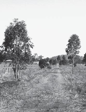
2 rail summar Location Trail summary The Brisbane Valley Rail Trail, when completed, will be a 148 kilometre recreation trail from Wulkuraka to Blackbutt. It will follow the old Brisbane Valley railway line and provide walkers, touring cyclists and horse riders with an opportunity to experience the history and landscape of the Brisbane Valley. The 19 kilometre Esk to Toogoolawah section of the Brisbane Valley Rail is northwest of Brisbane along the Warrego and Brisbane Valley Highways. The township of Toogoolawah is approximately 120 kilometres from the Brisbane CBD. Landscape heritage This section of the trail travels adjacent to Camp Creek and crosses Cressbrook Creek, a tributary of the Brisbane River, at Toogoolawah. The trail extends through farmland including lucerne, other pasture and small crops that are important to the local economy. Both townships have many sites of historical interest including churches, buildings and the Watts Bridge Memorial Airfield near Toogoolawah where various events are held throughout the year. Use The trail is for walking, cycling and horse riding only. The trail surface is gravel and unsuitable for road bicycles or personal mobility vehicles. No motorised vehicles of any type are allowed. Sections of the Brisbane Valley Rail Trail are classified: Easy grade: even surface Moderate grade: surface may be rough Advanced grade: rough surface On trail signage indicates classifications between Esk and Toogoolawah. The distance and trail facilities make this section suitable for people with a moderate to high fitness level. There are no drinking water or toilet facilities between Esk and Toogoolawah. Walking shoes or light hiking boots are required and horses must be shod. Distance Esk Ottaba: 12 kilometres Ottaba Toogoolawah: 7 kilometres
3 y Heritage Indigenous Toogoolawah is derived from the Aboriginal words dhoo (a generic term for tree) and goo/lawa, meaning crescent shaped or bent like a crescent moon. Yuggera and Ugarapul peoples are the traditional owners of the Toogoolawah district. Prior to European settlement in 1824, the landscape of South East Queensland (as elsewhere in Australia) was influenced and protected by millennia of Aboriginal stewardship. Indigenous use and management of the landscape maintained a balance between the land and human needs. The South East Queensland Traditional Owners Alliance now oversees archaeological research into the Indigenous heritage of the Brisbane Valley. Heritage European The first European settler in the Brisbane Valley was David McConnel, who took up the Cressbrook run in In the late 1880s his son James established a condensed milk factory on Cressbrook Creek and subdivided a large part of the run into dairy farms and the township of Cressbrook Creek (later Toogoolawah). The McConnel family was deeply involved in Toogoolawah s economic and social development, encouraging cultural, religious, sporting and economic activity. They employed a contractor to build homes for their farmers, donated land for church purposes, and promoted a variety of district clubs, organisations and societies. Expansion of the town coincided with the rail connection to Ipswich in 1904 and the purchase of the factory by the Nestlé and Anglo-Swiss Condensed Milk Company in Toogoolawah lays claim to one of the most significant events in Queensland history. In 1873, Queen Victoria sent a small herd of red deer as a gift after Queensland was named in her honour. The deer were released at Cressbrook Station in Toogoolawah and descendants of those deer can be found throughout the region today. Historic churches abound in the town of Toogoolawah
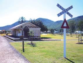
4 Esk trail station Services Public toilets, picnic facilities, post office and convenience stores are located at Esk and Toogoolawah. Trail users have many accommodation options in and around Esk and Toogoolawah. Horse accommodation and facilities are available at the showgrounds in Esk and Toogoolawah. Mobile phone coverage is good. Toogoolawah Minor road Mount Beppo Rd Old Mount Beppo Rd Angledale Ln Cressbrook Creek Morden Rd Key Fire Station Police Station Ottaba Calci te Rd s Linke Mt Beppo Community Hall Playground Ambulance Camping Water on tap Public Toilet Brisbane Valley Highway 17 Ln Accommodation Post office Horse yards Caravan or trailer sites Telephone Esk Cr ows Nest Rd Esk Kilcoy Rd Petrol Picnic area Visitor Information centre Parking area Highland St Esk
5 Do your part by modelling appropriate behaviour and leaving the trail as you found it. Please respect other users, the natural environment and the privacy of adjacent landholders. Before you use the trail, make sure you educate yourself and obtain trail maps and information, check the weather forecast and plan clothing, equipment and supplies accordingly. Sharing Park cars and trailers in designated areas. Please leave all gates as found. Observe local signs and regulations. Do not obstruct the trail. Cyclists must alert other users on approach and pass at a reduced speed. Approach horses with care. Keep dogs under control and on a lead. Environment Keep on the trail. Do not interfere with native plants or animals. Please dispose of all rubbish and animal waste appropriately. Do not light fires. Clean bikes, walking boots and other equipment after your trip to minimise the spread of plant and animal pests and diseases. Trail head and station grounds at Esk
6 For your safety and comfort Be cautious at all road and creek s. Cyclists and horse riders must wear approved safety equipment and ride in control. Do not approach or feed pets or livestock in adjacent properties. Carry drinking water and light snacks. Wear appropriate clothing for the conditions. Maintain your equipment, and carry repair and first aid kits for emergencies. Where possible, don t travel by yourself. Let a responsible person know where you are going and when you expect to return before you go. Emergencies Call 000 For more information Blackbutt Visitor Information Centre Hart Street, Blackbutt Esk Visitor Information Centre 82 Ipswich Street, Esk Fernvale Futures and Visitor Information Centre 1483 Brisbane Valley Highway, Fernvale Ipswich Visitor Information Centre 14 Queen Victoria Parade, Ipswich South Burnett Energy and Visitor Information Centre Corner Drayton and Henry Street, Nanango The Brisbane Valley Rail Trail is one of three regional recreation trails funded by the Queensland Government until 2012 and being delivered through a partnership between the Department of Infrastructure and Planning, Ipswich City, South Burnett and Somerset Regional Councils. Through Growth Management Queensland, the Queensland Government is protecting more land for public recreation to help shape tomorrow s Queensland. July 2010
Timeline for the development of the Brisbane Valley Rail Trail, 2006 to 2012 on behalf of Brisbane Valley Heritage Trails Inc.
 Timeline for the development of the Brisbane Valley Rail Trail, 2006 to 2012 on behalf of Brisbane Valley Heritage Trails Inc. Date: 09/08/2004 Event: Inspection of the proposed trail by 4WD, Linville
Lake Manchester RECREATION GUIDE. seqwater.com.au
 Lake Manchester RECREATION GUIDE seqwater.com.au About Lake Manchester OUR VISION To manage access to recreation opportunities while protecting natural resources and water quality. Lake Manchester is located
Lake Somerset RECREATION GUIDE
 Lake Somerset RECREATION GUIDE seqwater.com.au OUR VISION To manage access to recreation opportunities while protecting the natural resources and water quality About Lake Somerset Lake Somerset is located
Ewen Maddock Dam RECREATION GUIDE
 Ewen Maddock Dam RECREATION GUIDE seqwater.com.au About Ewen Maddock Dam OUR VISION To manage access to recreation opportunities while protecting natural resources and water quality. Ewen Maddock Dam,
Land Management Summary
 photo credit: ANGAIR Anglesea Heath Land Management Summary The Anglesea Heath (6,501 ha) was incorporated into the Great Otway National Park in January 2018. This provides an opportunity to consider the
Hydrology of Recent Flooding in South East Queensland
 Hydrology of Recent Flooding in South East Queensland G. Hausler TOPICS Prelude eu e Rainfalls Catchments Flooding Aftermath Prelude Sea Surface Temperature anomalies for December 2010 Most likely return
Bibbulmun Track. Cape to Cape Track. Two of the world s great long distance walking tracks. 973 km. 135 km km Off-road cycle touring
 Trail revitalising Western Australia Bibbulmun Track 973 km Cape to Cape Track 135 km Two of the world s great long distance walking tracks 1062 km Off-road cycle touring Trail revitalising 1. Framework
Lake Wivenhoe RECREATION GUIDE
 Lake Wivenhoe RECREATION GUIDE seqwater.com.au OUR VISION To manage access to recreation opportunities while protecting the natural resources and water quality About Lake Wivenhoe Lake Wivenhoe, located
Cooloolabin Dam RECREATION GUIDE. seqwater.com.au
 Cooloolabin Dam RECREATION GUIDE seqwater.com.au OUR VISION To manage access to recreation opportunities while protecting natural resources and water quality. About Cooloolabin Dam Cooloolabin Dam is located
ROSEHAVEN ROSEWOOD, IPSWICH, QLD
 ROSEHAVEN, IPSWICH, QLD Ipswich- Rd TRAIN LINE BREMER RIVER RAAF BASE IPSWICH CBD 5O MIN TO BRISBANE CBD Karrabin Rd Waight St Golf Course Laidley Rd High John St Town Centre St Brigid s Primary Station
Cooloolabin Dam Recreation Management Discussion Paper. November 2013
 Cooloolabin Dam Recreation Management Discussion Paper November 2013 Contents November 2013... 1 Background... 3 Overview of Cooloolabin Dam... 6 Weed Management... 7 Cultural Heritage... 7 Commercial
White Rock - Spring Mtn Conservation Estate
 White Rock - Spring Mtn Conservation Estate School Road, White Rock TRAILS OF IPSWICH www.ipswich.qld.gov.au Destination overview Proximity Paperbark Flats Picnic Area 14km (20 mins drive) from City centre
Stephens State Park Trails
 TRAILS OF ALLAMUCHY MOUNTAIN & STEPHENS STATE PARKS Allamuchy Mountain and Stephens State Parks contain 28 marked trails providing access to diverse landscapes for walking, hiking, biking, bird-watching,
Queensland. Stoneleigh Reserve, Logan Reserve. rivergumhomes.com.au freecall
 Stoneleigh Reserve, Logan Reserve rivergumhomes.com.au freecall 1800 675 706 2014 Rivergum Homes Pty Ltd, & Rivergum National Realty P/L trading as Rivergum Communities. While every reasonable care has
Recreation Management Plan Lakes Atkinson/Somerset/Wivenhoe
 Lakes Atkinson/Somerset/Wivenhoe November 2013 Contents Overview... 3 The Value of Our Natural Areas... 4 Management Approach... 6 Funding... 7 Recreation Management... 9 Conditions of Access and Use...
Lewis River Recreation Sites
 Lewis River Recreation Sites Parking Fees Hours Visitors entering day-use sites with vehicles must pay applicable fees during peak recreation season. * Pass holders, please check in with booth attendant
IOW Ramblers Submission Paper to the Sept 2016 ROW Improvement Plan Consultation.
 IOW Ramblers Submission Paper to the Sept 2016 ROW Improvement Plan Consultation. The current Island Rights of Way Improvement Plan is a comprehensive document and much of its content is still relevant
Our Murray River Beaches
 Page 1 of 5 Our Murray River Beaches Click here to print this page West of Yarrawonga are many access points to the river. Earth tracks lead from the Murray Valley Highway through state forests to picnic
Watchorn Provincial Park. Management Plan
 Watchorn Provincial Park Management Plan 2 Watchorn Provincial Park Table of Contents 1. Introduction... 3 2. Park History... 3 3. Park Attributes... 3 3.1 Natural... 4 3.2 Recreational... 4 3.3 Additional
Blair Castle Activities
 Atholl Estates Blair Castle Activities Explore Atholl Estates Off Road Safaris Experience the beauty and tranquillity of rural Scotland in just a few hours on an off road safari. Your expert guide will
Abbotts Falls Walking Track
 Abbotts Falls Walking Track 3 hrs 7.3 km Circuit Hard track 329m This circuit takes you through both dry and moist forest, using a combination of walking trails and wider tracks. The side trip to the dammed
Queensland infrastructure research
 Queensland infrastructure research Conducted for: infrastructure partnerships Australia Infrastructure association of Queensland Property council of Australia Presented to: Queensland Infrastructure Summit,
Lewis and Clark Recreation Area
 Lewis and Clark Recreation Area Bicycle/Pedestrian Trail Also part of the Pierson Ranch Recreation Area trail Type of trail: Walking, biking and rollerblading Trail surface: Asphalt Rated: Mostly flat.
Carnarvon Station Reserve, Qld Camping Information
 Carnarvon Station Reserve. Photo: Katrina Blake Carnarvon Station Reserve, Qld Camping Information Quick facts Acquired: 2001 Area: 59,000 ha Traditional owners: Bidjara Location: Central Highlands region,
60th Annual National Convention Hosted by South Western Model Engineers. Come help us celebrate 60 years of National Conventions
 60th Annual National Convention 2016 Hosted by South Western Model Engineers Come help us celebrate 60 years of National Conventions Cobden Miniature Railway Park COBDEN - VICTORIA INFORMATION KIT The
FAMILY CARAVAN AND CAMPING SITE RULES AND REGULATIONS
 FAMILY CARAVAN AND CAMPING SITE RULES AND REGULATIONS March 2018 March 2018 Family Caravan and Camping Site 2018 Cardiff Bay will play host to the 2018 National Eisteddfod, which will be held between 3
Lake Kurwongbah RECREATION GUIDE
 Lake Kurwongbah RECREATION GUIDE seqwater.com.au OUR VISION To manage access to recreation opportunities while protecting natural resources and water quality. About Lake Kurwongbah Lake Kurwongbah is located
MORAY COAST TRAIL - Notes on multi-use access
 MORAY COAST TRAIL - Notes on multi-use access The Moray Coast Trail in the north-east of Scotland is one of Scotland s Great Trails. Approximately 50 miles long, the route links settlements between Findhorn
Cracow 2013/2023 Place Based Plan
 Cracow 2013/2023 Place Based Plan Cracow Place Based Plan Page 1 The Cracow Place Based Plan is a controlled document. Please visit the Banana Shire Website at http://www.banana.qld.gov.au/index.php/71
NOHOANGA SITE INFORMATION SHEET LAKE HAWEA TIMARU RIVER (TIMARU CREEK) Getting there
 Getting there") NOHOANGA SITE INFORMATION SHEET LAKE HAWEA TIMARU RIVER (TIMARU CREEK) Getting there From the West Coast Wanaka highway (SH6), turn off at the dam and drive through Hawea Township until you join up with
NOHOANGA SITE INFORMATION SHEET LAKE HAWEA TIMARU RIVER (TIMARU CREEK) Getting there From the West Coast Wanaka highway (SH6), turn off at the dam and drive through Hawea Township until you join up with
A summary of Draft Makara Peak Mountain Bike Park Master Plan
 A summary of Draft Makara Peak Mountain Bike Park Master Plan OVEMBER 216 Image: Peter Marshall 2 3 Introduction Since it was established in 1998, the Makara Peak Mountain Bike Park (Makara Peak) has grown
Port Bruce. Interim Management Statement
 Port Bruce Interim Management Statement Port Bruce Interim Management Statement August 3, 1999 This Port Bruce Provincial Park Interim Management Statement provides direction for the custodial management
Quirindi War Memorial
 Liverpool Plains Quirindi War Memorial Fields of sunflowers, sorghum, canola, corn, lucerne and wheat provide the perfect backdrop whilst travelling through the picturesque hills, valleys and sweeping
Lewis River Recreation Sites
 Lewis River Recreation Sites N 0 miles 2 4 8 Parking Fees Hours Visitors entering day-use sites with vehicles must pay applicable fees during peak recreation season. * Pass holders, please check in with
Code of Conduct for Campers
 Code of Conduct for Campers Camping Rallies or Camping on Race Days One named member of the organisation/group (the rally marshal or responsible person ) is to be responsible for the conduct of any exempted
2017 Major Projects Pipeline Report Adrian Hart, Senior Manager Infrastructure & Mining
 2017 Major Projects Pipeline Report Adrian Hart, Senior Manager Infrastructure & Mining Major Projects Pipeline Report - 2017 Presentation Outline Overview and key findings of the 2017 Pipeline Report
Yard Creek Provincial Park. Management Plan
 Yard Creek Provincial Park Management Plan Draft January 2010 Yard Creek Provincial Park Management Plan Approved by: telàlsemkin/siyam/chief Scott Benton Bill Williams Squamish Executive Director ation
Eketahuna Community Board
 Eketahuna Community Board Minutes of a meeting of the Eketahuna Community Board held in the Eketahuna War Memorial Hall, corner of Jones Street and State Highway 2, Eketahuna on Friday 3 November 2017
Camping (Primitive) Camping (RV) Electrical Potable Water Grill Established Fire Pit Picnic Table
 Camping (RV) Electrical Potable Water Grill Established Fire Pit Picnic Table") Alden - 9th Road River Mile 777 Map: 38.20833, -98.32031 Managing Agency: Kansas Department of Wildlife, Parks & Tourism Nearest Community: Alden, Rice County Kansas Developed Amenities Provided Parking
Alden - 9th Road River Mile 777 Map: 38.20833, -98.32031 Managing Agency: Kansas Department of Wildlife, Parks & Tourism Nearest Community: Alden, Rice County Kansas Developed Amenities Provided Parking
Marchand Provincial Park. Management Plan
 Marchand Provincial Park Management Plan 2 Marchand Provincial Park Table of Contents 1. Introduction... 3 2. Park History... 3 3. Park Attributes... 4 3.1 Natural... 4 3.2 Recreational... 4 3.3 Additional
POLICY ON VISITOR USE AND ACTIVITIES IN PARRAMATTA PARK
 POLICY ON VISITOR USE AND ACTIVITIES IN PARRAMATTA PARK Contact Officer: Visitor Services Officer Policy Approval Date: 10 January 2017 Next Policy Review Date: 10 January 2019 Published Date: 13 January
ROYAL NAVY INTERNATIONAL AIR DAY RNAS YEOVILTON - SATURDAY 13 JULY ACCESS STATEMENT Last updated 2 Nov 2018
 ROYAL NAVY INTERNATIONAL AIR DAY RNAS YEOVILTON - SATURDAY 13 JULY 2019 ACCESS STATEMENT Last updated 2 Nov 2018 This access statement does not contain personal opinions as to our suitability for those
Mickelson Connector Feasibility Study
 Friends of the Norbeck PO Box 2003 Rapid City, SD 57709 www.friendsofthenorbeck.org Summary Comments on the Mickelson Connector Feasibility Study Prepared by Brian Brademeyer Submitted to Wyss Associates
NOHOANGA SITE INFORMATION SHEET TUCKERS BEACH, OTAGO. Tuckers Beach Road. Entry Point to Site. Getting there
 NOHOANGA SITE INFORMATION SHEET TUCKERS BEACH, OTAGO Getting there This site is within the Tuckers Beach Wildlife Reserve, at approximately 280 Tuckers Beach Road, 15mins drive north of Queenstown township.
Segment 2: La Crescent to Miller s Corner
 goal of the USFWS refuges is to conserve, protect and enhance fish, wildlife and plants and their habitats for the continuing benefit of the American people. Refuge lands are used largely for fishing,
MT ARTHUR CHALLENGE SPONSORSHIP PROSPECTUS.
 MT ARTHUR CHALLENGE Promoting physical fitness, the beautiful Mt Arthur Reserve and supporting the local community. SPONSORSHIP PROSPECTUS 2018 www.mtarthurchallenge.org.au EVENT INFORMATION The Mt Arthur
Lake Kurwongbah RECREATION GUIDE. seqwater.com.au
 Lake Kurwongbah RECREATION GUIDE seqwater.com.au OUR VISION To manage access to recreation opportunities while protecting natural resources and water quality. About Lake Kurwongbah Lake Kurwongbah is located
ONTARIO TRAILS COUNCIL FAQ
 Trail Facts Ontario has some of the most treasured and protected outdoor areas in the world with: 329 Provincial Parks 400 Conservation Areas 292 Conservation Reserves Many people link trails with recreation
GLASS HOUSE MOUNTAINS PEAKS WALK, BEERBURRUM TRAILHEAD DRAFT CONCEPT PLAN
 GLASS HOUSE MOUNTAINS PEAKS WALK, BEERBURRUM TRAILHEAD DRAFT CONCEPT PLAN GLASS HOUSE Figure 1 REGIONAL WALK/RIDE OVERVIEW Aspirational Goal Create an interconnected nature-based recreation trail network
Recreation Management Plan Lake Baroon and Ewen Maddock Dam
 Lake Baroon and Ewen Maddock Dam December 2013 Contents Overview... 3 The Value of Our Natural Areas... 4 Management Approach... 6 Funding... 7 Recreation Management... 8 Conditions of Access and Use...
ESSINGTON RISE. Leichardt, IPSWICH QLD
 ESSINGTON RISE Leichardt, IPSWICH QLD Riverlink Shopping Centre Ipswich CBD IGA Supermarket Railway Station Leichardt State School Ipswich Grammar School Home HQ Shopping Centre Sporting Fields Ipswich
Around and about Geraldine
 Around and about Geraldine A guide to recreational opportunities SOUTH CANTERBURY Track classifications Short walk Easy walking for up to an hour Track is well formed, with an even, welldrained surface.
STONES CORNER SUBURBPROFILE. Situated three kilometres from the Brisbane CBD, Stones Corner is located within one of Brisbane s key growth areas.
 1 SUBURBPROFILE Situated three kilometres from the Brisbane CBD, Stones Corner is located within one of Brisbane s key growth areas. OVERVIEW Situated three kilometres from the Brisbane CBD, Stones Corner
TALL TIMBER LEISURE PARK 2018/19 RULES and REGULATIONS (Board approved) March 24, 2018
 March 24, 2018") TALL TIMBER LEISURE PARK 2018/19 RULES and REGULATIONS (Board approved) March 24, 2018 The purpose of these Rules and Regulations are for the safety and enjoyment of all residents and their guests. The
TALL TIMBER LEISURE PARK 2018/19 RULES and REGULATIONS (Board approved) March 24, 2018 The purpose of these Rules and Regulations are for the safety and enjoyment of all residents and their guests. The
Whatungarongaro he tangata, toitu te whenua. People come and go but the land endures. leave no trace new zealand
 Pocket Guide Leave No Trace Leave No Trace New Zealand promotes and inspires responsible outdoor recreation through education, research and partnerships. This pocket guide is a part of an education programme
2015 Business Survey Report Erie to Pittsburgh Trail March 2015
 2015 Business Survey Report Erie to Pittsburgh Trail March 2015 Table of Contents Executive Summary 2 2013 EPT Trail User Survey and Impact Analysis 3 Overview 3 Results 3 2014 2015 Erie to Pittsburgh
Tasmanian Budget
 2016-17 Tasmanian Budget Thursday, 26 May 2016 TTF S TASMANIAN BUDGET AGENDA In the lead up to the Tasmanian Budget, TTF released a comprehensive submission outlining key budgetary and policy recommendations
The University of Georgia
 The University of Georgia Center for Agribusiness and Economic Development College of Agricultural and Environmental Sciences Georgia Agritourism Overview: Results from a 2005 Business Survey Center Report:
Access Statement for Rand Farm Park
 Access Statement for Rand Farm Park Introduction Rand Farm Park offers a high quality hands on fun and learning experience for all ages and abilities Large variety of animals to hold, feed, touch and cuddle
PAGE OF CONTENTS PAGE 3
 PAGE OF CONTENTS Pre Departure... 4 Travel Documentation... 5 Travel Fatigue & Planning Ahead... 6 Driving the Campervan... 7 Driving at Night... 8 Bushwalking... 9 Swimming... 10 Fire Restrictions...
WHAT is in YOUR Region?
 WHAT is in YOUR Region? Rural areas are not homogeneous. Despite overall trend of decline some are growing This growth is highly correlated to the presence of amenities which are speculated to drive rural
Access Statement for RNAS Yeovilton International Air Day
 AHA Events Ltd T 08445 780 780 Mayfair 1 The Square F 08445 780 401 Barnstaple E airday@ahagb.co.uk Devon EX32 8LS www.yeoviltonairday.co.uk This access statement does not contain personal opinions as
FAQS and Code of Conduct for use under the Tamar Trails heading on the Tamar Valley AONB and Tamar Trails websites: Tamar Trails FAQs
 FAQS and Code of Conduct for use under the Tamar Trails heading on the Tamar Valley AONB and Tamar Trails websites: Tamar Trails FAQs What are the Tamar Trails? The Tamar Trails are 25km of new and improved
Suburb Profile 12,700 FERNVALE POPULATION TO GROW BY LOCATION POPULATION AND DEMOGRAPHICS FERNVALE
 A DIVISION OF Suburb Profile LOCATION Fernvale is located within southeast Queensland s rapidly growing western corridor. The suburb is located 35 kilometres west of central Brisbane and 20 kilometres
Pembina Valley Provincial Park. Draft Management Plan
 Pembina Valley Provincial Park Draft Management Plan 2 Pembina Valley Provincial Park Table of Contents 1. Introduction... 3 2. Park History... 3 3. Park Attributes... 3 3.1 Natural... 3 3.2 Recreational...
Nov. 19 th Public Workshop Summary
 On November 19 th, more than 60 community members attended an Open Space Matters workshop at the Linen Building in downtown Boise for over two hours. Participants learned about reserves, discussed the
Twin Rivers Annual Report 2017
 Twin Rivers Annual Report 2017 Summary of our volunteer efforts for 2017 Volunteer Hours 2249 hours Trail Miles Cleared 37 miles Vehicle Miles Driven 10198 miles Equipment Hours 79 hours Stock Days 193
CORPORATE ACCOMMODATION SOLUTIONS
 CORPORATE ACCOMMODATION SOLUTIONS TABLE OF CONTENTS EXECUTIVE SUMMARY 3 THE LOCATION 4 KEY FEATURES 5 MASTERPLAN 8 TRANSPORT & PARKING 9 EAST VILLAGE 10 INDICATIVE SCHEME 11 ABOUT THE DEVELOPER 14 2 EXECUTIVE
March 14, SUBJECT: Public input to the Bureau of Land Management, Gunnison Field Office, Travel Management Plan
 March 14, 2019 Delivered via email to ewaters@blm.gov Elijah Waters Field Manager BLM Gunnison Field Office Gunnison, CO 81230 SUBJECT: Public input to the Bureau of Land Management, Gunnison Field Office,
Port Gamble Shoreline Area Conceptual Trail Proposal
 The North Kitsap Trails Association is pleased to be a partner to the Kitsap Forest and Bay Project and assist Kitsap County, Forterra, Olympic Property Group, Great Peninsula Conservancy and the Port
THE INVESTIGATOR DATE CLAIMER. Glasshouse Bushwalkers Club Inc. June - July Official Newsletter of the Glasshouse Bushwalkers Club Inc.
 THE INVESTIGATOR Official Newsletter of the Glasshouse Bushwalkers Club Inc. DATE CLAIMER In this issue: 11 JUNE 2017 Trachyte Circuit Walk with cancer survivors 25 JUNE 2017 Caboolture to Wamuran (Caboolture
Access Statement for RNAS Yeovilton International Air Day
 AHA Events Ltd T 08445 780 780 Mayfair 1 The Square F 08445 780 401 Barnstaple E airday@ahagb.co.uk Devon EX32 8LS www.yeoviltonairday.co.uk This access statement does not contain personal opinions as
JOBS FOR DARLING DOWNS
 JOBS FOR DARLING DOWNS Queensland Budget 2017-18 The Queensland Budget will directly support around 4,300 JOBS in Darling Downs in 2017-18. Infrastructure $917.9M for productivity enhancing infrastructure
Brisbane to Toowoomba Lakes Drive
 jhdfjkhdksfhdhjf Brisbane to Toowoomba Lakes Drive Brisbane to Toowomba via Esk Enjoy picturesque scenery, charming country towns and quirky gift shops on this scenic tour from Brisbane to Toowoomba taking
BREAK O DAY COUNCIL PO Box 21, St Helens, Tasmania 7216 Phone: (03) Fax: (03)
 Fax: (03)") BREAK O DAY COUNCIL PO Box 21, St Helens, Tasmania 7216 Phone: (03) 6376 7900 Fax: (03) 6376 1551 Email: admin@bodc.tas.gov.au www.bodc.tas.gov.au Contents: Introduction Mayor s Message NEW RESIDENT S
BREAK O DAY COUNCIL PO Box 21, St Helens, Tasmania 7216 Phone: (03) 6376 7900 Fax: (03) 6376 1551 Email: admin@bodc.tas.gov.au www.bodc.tas.gov.au Contents: Introduction Mayor s Message NEW RESIDENT S
Santa Clara South Hills Recreation Park Project Development and Management Plan
 Santa Clara South Hills Recreation Park Project Application for Land for Recreation or Public Purposes, City of Santa Clara, Utah Prepared for: Bureau of Land Management, St. George Field Office 345 East
RAY YENKANA Willowbrook Cr, Dawson Creek BC Canada $2,847,000
 1716 Willowbrook Cr, Dawson Creek BC Canada For SALE $2,847,000 This is a rare find, 32 townhomes in Dawson Creek, BC. Excellent investment in a single title multi family complex. Vendor has upgraded this
STAGE TWO BOT BO TLE LEBRUSH RE RELE LEASE
 STAGE TWO BOTTLEBRUSH RELEASE BOTTLEBRUSH RELEASE FREE FENCING AND FRONT YARD LANDSCAPING Conditions apply. Refer to your contract of sale for more details. The Bottlebrush Release features a selection
County of Peterborough Active Transportation Master Plan
 The TMP developed a conceptual AT/cycling network for Peterborough County that identified both on-road and off-road (trail) AT facilities. This was a coarse network based on the existing trails and off-road
Welcome to the future of Terwillegar Park a Unique Natural Park
 Welcome to the future of Terwillegar Park a Unique Natural Park 1 Introduction The Terwillegar Park Concept Plan study will develop an overall concept plan, management objectives and development guidelines
KAWATHA TRANS CANADA TRAIL ADJACENT PRIVATE LAND OWNERSHIP SURVEY
 KAWATHA TRANS CANADA TRAIL ADJACENT PRIVATE LAND OWNERSHIP SURVEY Al MacPherson, President KTCTA Dr. John Marsh, Trail Studies Unit, Trent University October 2015 KAWATHA TRANS CANADA TRAIL ADJACENT PRIVATE
Discover. Ashhurst Domain. Nature s Playground
 Discover Ashhurst Domain Nature s Playground Discover Step back into New Zealand, Aotearoa, of generations long gone. Discover lush natural surrounds echoing with rich birdsong in one of the Manawatu s
Other Agencies and Organizations
 Daniel Boone National Forest 1700 Bypass Road WInchester, KY 40391 859-745-3100 Location Northern terminus is near Morehead, Kentucky. Southern terminus is located in the Big South Fork NRRA in Tennessee.
THE INVESTIGATOR DATE CLAIMER. Glasshouse Bushwalkers Club Inc. Apr Official Newsletter of the Glasshouse Bushwalkers Club Inc.
 Apr 2018 THE INVESTIGATOR Official Newsletter of the DATE CLAIMER In this issue: 22 APR 2018 Baroon Pocket Dam to Kondalilla Falls - Day walk In later issues 5-7 MAY 2018 Central Qld Combined Camp, Mount
Lake Baroon RECREATION GUIDE
 Lake Baroon RECREATION GUIDE seqwater.com.au About Lake Baroon OUR VISION To manage access to recreation opportunities while protecting natural resources and water quality. Lake Baroon, located between
SOLUT SPREAD 9 30 TH. Calgary, AB, Canada T2R 0K1
 MANITOBA METIS FEDER ATION MATRIX SOLUT IONS INC. PARTNERSHIP INDIGENOUS CONSTRUCTION MONITORING WEEKLY REPORT SPREAD 9 SEPTEMBER 24 TH TO SEPTEMBER 30 TH Suite 600, 214 11 Ave. SW Calgary, AB, Canada
Te Awa is a shared cycle/walkway travelling 70 kms along the banks of New Zealand s largest & longest river the Mighty Waikato.
 Te Awa is a shared cycle/walkway travelling 70 kms along the banks of New Zealand s largest & longest river the Mighty Waikato. Project completion date 2013 Ngaruwahia - Hamilton Completion Early 2012
Connected to memories. And the future.
 Connected to memories. And the future. Remember what it was like when you were a kid? How you used to play outdoors with the other kids from your street without a care in the world. It seems like a simpler
2016 Regional Transportation Alternatives Program (TAP) Grant Application
 Grant Application") 2016 Regional Transportation Alternatives Program (TAP) Grant Application PROJECT TITLE: Yelm-Tenino Trail Extension Feasibility Study TRPC use only GENERAL PROJECT INFORMATION Agency or Organization City
2016 Regional Transportation Alternatives Program (TAP) Grant Application PROJECT TITLE: Yelm-Tenino Trail Extension Feasibility Study TRPC use only GENERAL PROJECT INFORMATION Agency or Organization City
DAY 1: Emu Plains to Glenbrook Wednesday, January 2, 2019
 DAY 1: Emu Plains to Glenbrook Wednesday, January 2, 2019 Some sun: 34 C / 21 C 3mm Meeting time: 8.00am @ Our Lady of the Way Catholic Church, Emu Plains [15 Troy Street, Emu Plains; altitude: 32m] Mass:
APPENDIX 5: JUNEAU NORDIC SKI CLUB MEMO
 APPENDIX 5: JUNEAU NORDIC SKI CLUB MEMO To all participants in the McDowell Eaglecrest nordic long-range planning meeting: It was good to meet with all of you last month and talk about our vision for the
LANGPORTS ENGLISH + VOLUNTEERING PROGRAMS
 LANGPORTS ENGLISH + VOLUNTEERING PROGRAMS www.langports.com ENGLISH + VOLUNTEERING PROGRAMS AT LANGPORTS To complement our existing programs, Langports is now offering students increased opportunities
Antique Weekend Drive. Brisbane to Toowoomba Take in a little culture and history as you travel through Ipswich and Toowoomba.
 Antique Weekend Drive Brisbane to Toowoomba Take in a little culture and history as you travel through Ipswich and Toowoomba. Brisbane to Toowoomba Antique Weekend Drive This trip makes for a relaxing
THIS IS FUN FLYING AT ITS BEST, SO COME ON EVERYONE - GIVE IT A GO!!
 The Brisbane Valley Sport Aviation Club s Fun Fly Poker Run will be held on Saturday 7th July 2018. Starting time is 9:00am and finishing at 2:00pm. It doesn t matter what you fly Recreational, Homebuilt,
Doolarie Singh-Knights (Ph.D.) Extension Specialist, West Virginia University Morgantown, WV
 Extension Specialist, West Virginia University Morgantown, WV") DRAFT Assessing the Agritourism and Farm-Based Education Potential of your Region and your Farm Property Doolarie Singh-Knights (Ph.D.) Extension Specialist, West Virginia University Morgantown, WV Adapted
DRAFT Assessing the Agritourism and Farm-Based Education Potential of your Region and your Farm Property Doolarie Singh-Knights (Ph.D.) Extension Specialist, West Virginia University Morgantown, WV Adapted
Common Sense and the Right of Public Access
 Edition 2: May 2004 ENGLISH Common Sense and the Right of Public Access Photo: Johnér/Hans Bonnevier Do not disturb, do not destroy that is the basic principle of Sweden s right of public access. It is
SOVEREIGN PARK. An Exclusive Investment Opportunity. Brassall, QLD Located in Australia's Fastest Growing City. Creating Cashflow Through Property
 An Exclusive Investment Opportunity Located in Australia's Fastest Growing City Sovereign Park Estate Sovereign Park Estate is an exclusive opportunity for investors to secure pre-construction pricing
The Great New Zealand River Ride
 The Great New Zealand Overview River Ride The concept of the national cycleway was proposed at the Employment Summit in February 2009 by the newly elected National government. Objectives for the Cycleway
In your group you are going to prepare a one minute talk on travelling safely.
 In your group you are going to prepare a one minute talk on travelling safely. >> On your group s sheet are a list of questions to think about to help you get started with planning your talk. >> You might
Prince Edward Island National Park of Canada
 Prince Edward Island National Park of Canada Things you should know regarding Cavendish and Stanhope Campgrounds Updated October 20, 2017 Important Notices: Important Notices General Camping Information