Flooding analysis of Karst Poljes in Bosnia & Herzegovina
|
|
|
- Ralph Nichols
- 6 years ago
- Views:
Transcription

1 Flooding analysis of Karst Poljes in Bosnia & Herzegovina Ulrich Schwarz FLUVIUS, Vienna
2 For further information please contact: Romy Durst Euronatur Konstanzerstrasse 22 D Radolfzell Dr. Ulrich Schwarz FLUVIUS Hetzgasse 22/7 A-1030 Vienna This document has been produced by: Ulrich Schwarz, FLUVIUS, Vienna Acknowledgements: Borut Stumberger Cover photo: Livanjsko Polje, Ulrich Schwarz 1
3 Table of Contents Flooding analysis of Karst Poljes in Bosnia & Herzegovina 1. Introduction and aim of the study Methodology Background Geomorphological definition Hydrology Analysis of DEM Analysis of maps Analysis of event documentation and other sources Definition of flood outlines Results (factsheets for Poljes) Bjelajsko polje Borovo polje Carevo polje Cernica Crničko polje Dabarsko polje Dobranjsko polje (Livno) Donje Zijemlje Dugo polje Dugo polje (Dugorudo) Duvanjsko polje Fatničko polje Gatačko polje Glamočko polje Grab polje Gradac Grahovsko polje Hansko polje (Gornje Zijemlje) Hutovo blato (Deransko-Svitavsko polje) Imotsko polje (Bekijsko polje) Jasenpolje Kočerinsko polje Konjsko polje Kruško polje Kupreško polje
4 3.26 Livanjsko polje Ljubinsko polje Ljubomir polje Lukavačko polje Marinkovci Medeno polje Mokro polje (Široki Brijeg) Mokro polje (Trebinje) Mostarsko blato Nevesinjsko polje Orahovac polje Palanka (Lušci polje) Pašića polje Petrovačko polje Plana Podrašničko polje Popovo polje Posušje Rakitno Rašanjsko polje (Rasno) Rastoka i Ljubuško polje Ravanjsko polje Ravna Mliništa Roško polje Rudno polje Slato polje Studeničko polje Šuičko polje Trusinsko polje Viničko polje Vučipolje Vukovsko polje Conclusions References
5 1. Introduction and aim of the study Karst poljes in the Dinarides and in particular in Bosnia & Herzegovina can be characterised as one of the most fascinating landscapes in the Balkan region. Due to the geological and hydrological circumstances (huge carbonate and karst mountains mostly under Mediterranean climate combined with rather high precipitation and water supply from the mountain ridges) an extensive number and area of poljes mostly interconnected by groundwater systems on different altitude levels (from 2-1,200 m above sea level), hosting a wide range of habitats and species (Mediterranean to alpine biogeographical units) in close vicinity was built since last ice age (during last 20,000 years). Poljes are often very fertile and would have a great importance for human development and agricultural production in the mountainous area of Balkans. However many poljes are regularly flooded, even for several months and only the techniques available since a century make it possible to drain and meliorate poljes in a larger scale by controlling the water in and outflows, in particular during the flooding season (mostly in winter and spring time). Several larger poljes were significantly altered. Parts are lost by the enlargement of settlements and infrastructure or are used even for the exploitation of peat/lignite for heating power plants. Due to the regular flooding poljes were used intensively for pasturing and meadows over the past 3,000 years, leading to an extensive very rich habitat mosaic namely for plant and bird species, in particular where near-natural flood tolerant forests stands and natural streams and river banks and bars were preserved, like in Livanjsko polje, which was therefore declared as Ramsar site (wetland). The study try to summaries the potential flooding situation (only maximum water levels no duration) in the poljes to highlight the most sensible habitat areas, but to show also the potential flood risk for adjacent settlements and infrastructure even if flood dikes will be partially constructed preventing flooding from surface). All the analysis is based on the extensive preparation work (delineation and first flood classification of Karst Poljes) by Stumberger from
 flooding.")
6 2. Methodology Flooding analysis of Karst Poljes in Bosnia & Herzegovina The main goal is the identification of flood areas for the more or less frequent and regular flooding and the potential flooding including all those areas protected by dikes from (surface) flooding. Due to the very scattered data situation (in particular hydrological data) the applied approach is basing on the elevation model, the flood documentation in the field and secondary information such as historical maps, case studies and of course the very first raw flood classification by Stumberger Background Geomorphological definition Following the EPA Glossary of Cave and Karst Terms (EPA, 2009) a karst polje, in geological terminology, is a large, flat-floored depression within karst limestone, whose long axis develops in parallel with major structural trends (mountain ridges) and can become several kilometers long. Superficial deposits tend to accumulate along the floor. Drainage may be either by surface watercourses (as an open polje) or by swallow holes (as a closed polje) or ponors (holes and clefts where parts or the entire surface discharge can be disappear). Usually, the ponors cannot transmit entire flood flows, so many poljes become flooded or even wetseason lakes. The structure of some poljes is related to the geological structure, but others are purely the result of lateral dissolution and planation. The development of poljes is fostered by any blockage in the karst drainage. The flat floor of a polje may consist of bare limestone, of a nonsolvable formation, or of soil. A polje typically shows complex hydrogeological characteristics such as exsurgences, estavelles, swallow holes, and lost rivers. The margin along the surrounding mountain foot is the most active hydrological exchange zone. Figure 1: Overview of the distribution of karst polje in the Dinaric region (from Lewine 2009) 5

7 Figure 2: Overview of the distribution of karst polje in Bosnia & Herzegovina used for the analysis (data from Stumberger) 6

8 2.1.2 Hydrology Karst hydrology is a very complex issue and the water balance of only one Polje can be very difficult to determine or even measure (e.g. by tracer experiments). Many gauges would be necessary to measure all in and outflows in particular for the underground water. Not only in smaller poljes the water levels can be rise extraordinarily high: Usually the water levels differ from 2-5 m over large areas but can reach m easily and for some polyes they can reach up to 80 m due to the narrow topography and valley form and possibilities for water to leave the polje. Figure 3: Basic karst features in polje landscapes (after Still 2007) 2.2 Analysis of DEM The first major analysis step is the evaluation of elevation data coming from ASTER 2 data (ASTER GDEM v2 data 2011). Aside of several limitations such as the resolution and the visualization of elevation artifacts the ASTER data is the best available free digital elevation model. Basically the elevation information for the rather plain less vegetated polje areas (mostly grassland) is good and can be estimated by an accuracy of 30x30 m² per pixel by a high accuracy between 2-5 m. Calculating the model for larger areas in poljes areas with differing altitude information such as Forests or infrastructure can be rather good recognized and excluded from the flood area calculation (if surrounding area is deeper and the proof by satellite images and maps is given, the area was assumed as flooded, e.g. flooded forests). Regarding the provided GIS polygons from earlier projects unfortunately the database has a limited resolution and the spatial fit (projection) of the data is in an former national Yugoslavian datum and must be transformed to UTM or decimal degrees in ETRS89 (this should be done in the future as well as amendments for the polje delineation, which was not subject of this elaboration). 7

9 2.3 Analysis of maps In a second analysis run the resulting elevation maps were directly overlaid with the landuse/habitat information available by free satellite images such as Google and Bing maps. The results changed and improved also the existing outline for many poljes. Areas on higher terrain hosting dry brush land can be excluded from the current but in most cases not from the potential flooding. 2.4 Analysis of event documentation and other sources Unfortunately the exiting documentation of polje flooding is rather poor, however the local people has good long-lasting experiences of average and catastrophic events, at least for some localities. The current Euronature photo documentation (Euronatur ) over the last 10 years which was provided for the project allow at least an initial analysis and where meaningful those photographs were added to the respective poljes in the result chapter. Detailed studies such as those from Schwarz (2010) for the Livanjsko polje directly provide flood outline information to the data. Regarding historical maps at least for larger poljes the Österreichische Generalkarte 1:200,000 ( ) was used to verify the basic extend of poljes and main river curses. Figure 4: Example for historical maps for the Buško Blato area (Österreichische Generalkarte 1:200,000 ( ). Additional available satellite quick-look information was screened and at least for the larger poljes some additional information was obtained, in particular only for a very few situationsregarding the flooding period (time steps, start and duration of flooding). 8
10 2.5 Definition of flood outlines In the last step the final result of flood outlines was carried out based on previous three steps by an assessment of each individual polje. Namely the flood outlines were prepared: 1. The current maximum flood outline proved by documentation. Unfortunately it is nearly impossible to define a kind of return interval, but in best case it should represent the maximum flood outline in the last century meaning a 100 years event as usual also for river gauges. 2. The maximum potential flood outline, not considering any flood protection dikes or structures/canals based only on the elevation model by using a certain buffer in high. As mentioned for the first outline it is impossible to define the return intervals, but it would be the multi century flood outline similar to those defined as morphological floodplains for rivers, meaning the maximum potential extend of flooding. 3. Results (factsheets for Poljes) This following chapter will give on each two pages the most important findings as short factsheets/maps for the analysed 57 karst poljes in alphabetical order. Explanation: The maps on left side include a Google earth snapshot and some basic information (Stumberger 2010) together with a photograph and a short text to the flood situation, the maps on right side show a meaningful colored elevation model (ASTER) in elevation classes (m; in best case one m steps for the bottom, for larger poljes however also classes of 2-5 or even 10 m; therefore the coloring is not uniform and the colors indicate only the differences in a good, visual way), the polygon for each polje and the flood outlines (one dark blue bold outline for the active maximum flooding considering field records and flood defenses and in grey the additional potential flooded area; in case of no evidence for active flooding only the potential grey outline is visualised). 9

11 3.1 Bjelajsko polje Flooding analysis of Karst Poljes in Bosnia & Herzegovina Based on vegetation and landuse this polje is only potentially flooded. 10

12 11

13 3.2 Borovo polje Flooding analysis of Karst Poljes in Bosnia & Herzegovina This polje over 1,000 m above sea level is mostly dry, surrounded in its southeastern part by Dolines and rock fields. The landscape of much deeper southeastern part (compare map on next page) is not connected to Borovo polje. 12

14 13

15 3.3 Carevo polje Flooding analysis of Karst Poljes in Bosnia & Herzegovina This very small polje is totally dry. 14

16 15
.")

17 3.4 Cernica The polje is regularly flooded (deepest pools are than up to 30 m). There are no significant structures inside therefore the active and potential flood extent is equal. Flood picture from east to west (Google Panoramio). 16
18 17


19 3.5 Crničko polje Flooding analysis of Karst Poljes in Bosnia & Herzegovina Basically there is no reference for flooding of this polje. However the vegetation and remnants of fluvial activity indicate a potential for flooding. Regarding the raw elevation information the potential areas was delineated by some 10 m altitude difference) Some smaller water bodies in the central part (Jasminko Mulaomerovic). 18

20 19


21 3.6 Dabarsko polje Flooding analysis of Karst Poljes in Bosnia & Herzegovina Still one of the best preserved poljes and regularly flooded. In its upper part two roads crossing the polje bottom and will prevent frequent flooding of same smaller areas. Flooded polje from southeast to northwest, January (Borut Stumberger). 20
22 21

23 3.7 Dobranjsko polje (Livno) No flood evidence is given for this polje, only several small karst springs and creeks on its eastern margin indicate potential flooding. 22

24 23


25 3.8 Donje Zijemlje Flooding analysis of Karst Poljes in Bosnia & Herzegovina This polje is situated on a karst fan on its western part including fluvial land forms assuming a flood potential for the lower central part. Pattern of vegetation depending on soil wetness indicate the potential flooding (Google Panoramio). 24

26 25

27 3.9 Dugo polje Flooding analysis of Karst Poljes in Bosnia & Herzegovina Only the low laying part used as agricultural fields could be potentially flooded. 26

28 27

29 3.10 Dugo polje (Dugorudo) This mountain polje with the Blidinje Lake (1,180 m above see level) host the largest mountain lake in Bosnia. Flooding occurs only in the southwestern lower part and potentially around the lake. 28

30 29


31 3.11 Duvanjsko polje Flooding analysis of Karst Poljes in Bosnia & Herzegovina A large more or less entirely agricultural used polje which is regular flooded. Flooded polje during winter season, January (Borut Stumberger). 30

32 31


33 3.12 Fatničko polje Flooding analysis of Karst Poljes in Bosnia & Herzegovina A beautiful large and extensively flooded polje with no settlement on the valley floor. From Northwest during flood season, January (Borut Stumberger). 32

34 33


35 3.13 Gatačko polje Flooding analysis of Karst Poljes in Bosnia & Herzegovina Huge and heterogeneous polje, in its northwestern part lignite are exploited for energy production. The polje included near natural karst river courses. Phantastic meandering melting rivers and springs indicating the flood period in the northeastern corner, building meander and fans (Borut Stumberger). 34

36 35


37 3.14 Glamočko polje Flooding analysis of Karst Poljes in Bosnia & Herzegovina This polje has a unique shape and is pristine in its southeastern part and scattered settled and invariant in its northwestern area. Flood lake in the southern pool in January (Borut Stumberger). 36

38 37

39 3.15 Grab polje Flooding analysis of Karst Poljes in Bosnia & Herzegovina Potential flooding occurs potentially only along the creek fan in the southern area. 38

40 39

41 3.16 Gradac No regular and significant flooding can be expected for this polje. 40
42 41


43 3.17 Grahovsko polje Flooding analysis of Karst Poljes in Bosnia & Herzegovina This polje is basically dry over large areas, but the central southern part includes some area with karst streams and wet meadows indicating a temporary water cover. Central-south flood area from plane, January (Borut Stumberger). 42

44 43

45 3.18 Hansko polje (Gornje Zijemlje) Only potentially flooded in its southern part. 44

46 45


47 3.19 Hutovo blato (Deransko-Svitavsko polje) One of the most wet poljes (reed beds) and strongly protected the Hutovo blato is directly connected to the Neretva lowlands and the potentially flooded area can be estimated by the comparison with the elevation model on the next page. The artificial reservoir in the south is part of the hydropower system and was earlier a similar wetland. This view from southwest shows the entire flooded area and the submerged meadows in front of the flood dikes caused by groundwater (Borut Stumberger). 46

48 47


49 3.20 Imotsko polje (Bekijsko polje) This polje at the border to Croatia is flooded regularly in its central part. The Matica river is collected in its southeastern part for hydropower generation. Also in the far western corner river regulation and canalization to collect water changed the flooding situation in this part of the polje. Further significant typical forest stands can be find in the central part. Flood in the central part, March (Borut Stumberger). 48

50 49
.")
51 3.21 Jasenpolje Flooding analysis of Karst Poljes in Bosnia & Herzegovina This rather densely settled polje with agricultural landscape is associated with a terraced second polje (right middle part of the image). Flooding occurs only in the meadow valley bottoms. 50

52 51


53 3.22 Kočerinsko polje Flooding analysis of Karst Poljes in Bosnia & Herzegovina This polje has a clearly defined flood bottom. Small flood in the main depression on March (Borut Stumberger). 52

54 53

55 3.23 Konjsko polje Flooding analysis of Karst Poljes in Bosnia & Herzegovina No flooding at all can be presumed for this polje. Only the very most northwards part indicates more wetness. 54

56 55

57 3.24 Kruško polje Flooding analysis of Karst Poljes in Bosnia & Herzegovina This high laying polje surrounded by doline fields is basically not flooded. 56

58 57
.")
59 3.25 Kupreško polje Flooding analysis of Karst Poljes in Bosnia & Herzegovina There is a wide range of fluvial forms in this polje reaching some reed beds and peat areas in the north to meandering rivers in the south. A road crossing the polje and drainage allow agricultural fields. One of the permanent water courses with dense sedge beds, (Borut Stumberger). 58

60 59

.")
61 3.26 Livanjsko polje Flooding analysis of Karst Poljes in Bosnia & Herzegovina The largest among all Bosnian karst fields still host typical huge areas of wetlands, meadows, forests, dry habitat components and is protected. In the south the Busko hydropower plant lake is regulating the water flow (exclusion of several areas from flooding). Left: Large regular and long-lasting flooding in the northern and middle part of the polje (Borut Stumberger). Rigth: Huge temporal karst spring and flood water marks (Dejan Kulier). 60

62 61

63 3.27 Ljubinsko polje Flooding analysis of Karst Poljes in Bosnia & Herzegovina The flood is limited to the vicinity of the active river channel. 62

64 63

65 3.28 Ljubomir polje Flooding analysis of Karst Poljes in Bosnia & Herzegovina Flooding occurs only in the central part along a meandering karst river. 64

66 65


67 3.29 Lukavačko polje Flooding analysis of Karst Poljes in Bosnia & Herzegovina This bottom like polje is only partially flooded in its deepest areas. Some permanent water bodies in the deepest points of the polje (Dejan Kulier). 66

68 67

69 3.30 Marinkovci Flooding analysis of Karst Poljes in Bosnia & Herzegovina This polje seems to be entirely dry. 68

70 69

71 3.31 Medeno polje Flooding analysis of Karst Poljes in Bosnia & Herzegovina The relief of this polje is rather uneven and only a very small area along a central chute could be potentially flooded. 70

72 71


73 3.32 Mokro polje (Široki Brijeg) Flooded in its western central part. View into the most frequently flooded part, January (Martin Schneider-Jacoby). 72

74 73


75 3.33 Mokro polje (Trebinje) Associated with the huge Popovo polje and Trebisnijca river the polje is separated in an upper and lower part by a road dam preventing the flooding of lower parts. January flooding from the cross dike showing the southeastern flooded part (Google Panoramio). 74

76 75


77 3.34 Mostarsko blato Flooding analysis of Karst Poljes in Bosnia & Herzegovina The rather huge and frequently flooded polje is feed by river Lisitca and by underground filling up the bath tube before the water is running through underground to the Neretva Valley (Jasenica is the name of this new short river before entering Neretva) which is 200 m below. Frequent flooded polje bottom, with flood tolerant grass species and willow groups also indicating the high flood dynamic of this polje by the debris flood marks April (Borut Stumberger). 76

78 77

.")
79 3.35 Nevesinjsko polje Flooding analysis of Karst Poljes in Bosnia & Herzegovina Larger flooding occurs in particular in the southern part of the polje along the Zalomka river (flood amplitude is up to 15 meters referencing a road bridge, the riverbed dry out during summer). Picture from plane showing the partially flooded central part (Borut Stumberger). 78

80 79

81 3.36 Orahovac polje Flooding analysis of Karst Poljes in Bosnia & Herzegovina The polje terrain is rather variable including a lot of rocky islands, No flood evidence for this polje. 80

82 81

83 3.37 Palanka (Lušci polje) Flooding analysis of Karst Poljes in Bosnia & Herzegovina Flooding occurs primarily in three separated depressions. 82

84 83


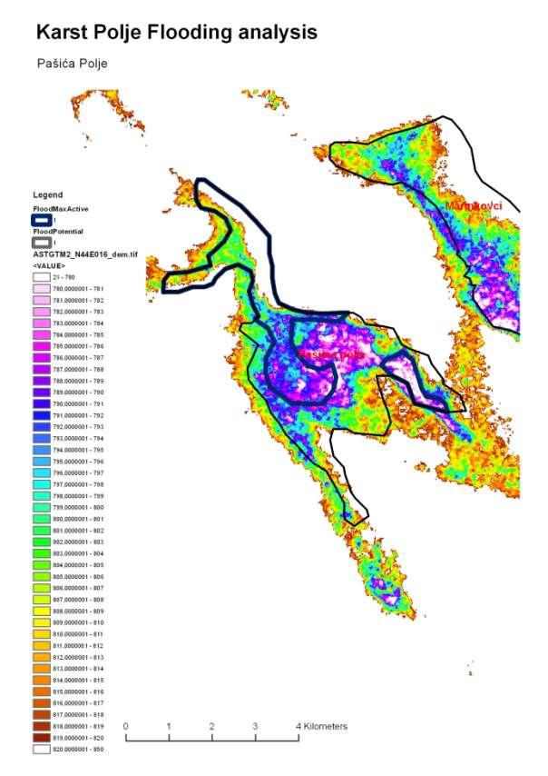
85 3.38 Pašića polje Flooding analysis of Karst Poljes in Bosnia & Herzegovina This polje is very dry in the southeastern lower part, but wet and regularly flooded in its western and northeastern branches. Documentation photo from air plane showing the northeastern flood basin January (Borut Stumberger). 84
86 85

87 3.39 Petrovačko polje Flooding analysis of Karst Poljes in Bosnia & Herzegovina Karst river driven flooding in smaller areas. 86

88 87

89 3.40 Plana The polje seems to be mostly not flooded at all. 88

90 89

91 3.41 Podrašničko polje Flooding analysis of Karst Poljes in Bosnia & Herzegovina Meandering, in its upper parts incised karst rivers with woody galleries characterizing this polje. 90

92 91


93 3.42 Popovo polje Flooding analysis of Karst Poljes in Bosnia & Herzegovina This long east-west shaped polje is flow trough by Trebisnjica river with is nearly entirely canalized or stored in reservoirs for irrigation and hydropower generation. Therefore the polje is strongly altered and large areas are completely cut from flooding at all. However the polje is still subject of extensive flooding and some areas of high protection value remain. Not a hydropower lake but the regular spring flooding: In its lower tubular stretch the flood water can accumulate up to 40 m (Borut Stumberger). 92
94 93

. Flooding in the eastern depression (Martin Schneider-Jacoby).")
95 3.43 Posušje The eastern depression is frequently flooded even if the altitude is much above the western part of the polje (the water leave the area by underground joining neighboring river catchments in the west). Flooding in the eastern depression (Martin Schneider-Jacoby). 94

96 95


97 3.44 Rakitno The polje is regularly flooded by karst streams in its central part. The lower part is clearly separated by karst rock formations and most properly rather dry. View of the wet upper part of the polje, typical extensive grazing grounds (Google Panoramio). 96

98 97


99 3.45 Rašanjsko polje (Rasno) Flooding occur in the western depression. Western part with partial flooding (Google Panoramio). 98

100 99

101 3.46 Rastoka i Ljubuško polje This poly is flow trough by Trebizat river flooding significant areas in its central northern part. 100

102 101

103 3.47 Ravanjsko polje Flooding analysis of Karst Poljes in Bosnia & Herzegovina Not regularly flooded polje (the lower areas in the southeastern part are entirely used for agriculture and include rocky karst elements, only the central part indicates a little more wetness. 102

104 103
 polje surrounded by forests is")

105 3.48 Ravna Mliništa Flooding analysis of Karst Poljes in Bosnia & Herzegovina This high laying (1,150 m) polje surrounded by forests is flooded only in smaller parts in the center. View of the flood basin (the small road in the middle right has a concrete bridge) (Jasminko Mulaomerovic). 104

106 105

107 3.49 Roško polje Flooding analysis of Karst Poljes in Bosnia & Herzegovina Flooding is evident only on smaller areas like in the northwestern part. 106

108 107

109 3.50 Rudno polje Flooding analysis of Karst Poljes in Bosnia & Herzegovina This is mostly a dry polje including in its central part also dry rocky karst elements. However it is covered mostly by grasslands. 108

110 109


111 3.51 Slato polje Flooding analysis of Karst Poljes in Bosnia & Herzegovina Beautiful small polje flooded in its deepest part. Flooded polje on January (Borut Stumberger). 110
112 111

113 3.52 Studeničko polje Flooding analysis of Karst Poljes in Bosnia & Herzegovina Kravica river is feeding this polje, flood occurs along rivers, but the polje floor is used mainly for agriculture. 112
114 113


115 3.53 Šuičko polje Flooding analysis of Karst Poljes in Bosnia & Herzegovina This picturesque polje is a kind of floodplain. Beautiful river meander flooded by melting water, upstream, January (Dejan Kulijer) 114
116 115

117 3.54 Trusinsko polje Flooding analysis of Karst Poljes in Bosnia & Herzegovina Flooding occur only in the western part. 116

118 117

119 3.55 Viničko polje Flooding analysis of Karst Poljes in Bosnia & Herzegovina Flooding occurs in the lowest western part. 118

120 119

121 3.56 Vučipolje Flooding analysis of Karst Poljes in Bosnia & Herzegovina The polje is situated in a dry high plain surrounded by rocky formations and is not usually flooded. 120

122 121


123 3.57 Vukovsko polje Flooding analysis of Karst Poljes in Bosnia & Herzegovina This polje is only scattered flooded in its western part along several small karst creeks. After summer grazing period, October (Borut Stumberger) 122

124 123
125 4. Conclusions Flooding analysis of Karst Poljes in Bosnia & Herzegovina The quick analysis prepared for the karst poljes in Bosnia & Herzegovina indicate for a large area first time a commonly used methodology to approximate potential flooding in polje landscape mainly by analyzing the elevation model in combination with field indication of flood events within the last 10 years and various other sources. The results clearly indicate the importance of flooding for many poljes and the need of sustainable usage and only absolutely necessary flood protection for infrastructure and settlements. Out of the 57 poljes with a total area size of 152,574 ha in 37 poljes (67,507 ha) regular flooding can presumed and additionally in 9 at least potential flooding can be expected. Only 10 poljes are mostly dry. All together the maximum potential for flooding is 80,261 ha. Further analysis must use hydrological data to be able to evaluate flood events, returning intervals and flood duration, which is important for the habitats in the poljes. The poljes are integral part of the Blue heart of Europe for the Balkan rivers, closely linked to floodplains and river flooding (Schwarz 2012). KarstField Total Size ha Max Flood Record ha Potential Max Flood ha Borovo polje Carevo polje Konjsko polje KruÜko polje Marinkovci Orahovac polje Plana Ravanjsko polje Rudno polje VuÞipolje Hansko polje (Gornje Zijemlje) Gradac RoÜko polje Medeno polje Ravna MliniÜta RaÜanjsko polje (Rasno) Dobranjsko polje (Livno) Trusinsko polje StudeniÞko polje Donje Zijemlje Dugo polje Grab polje Vukovsko polje Jasenpolje LukavaÞko polje Mokro polje (èiroki Brijeg)
126 KarstField Total Size ha Max Flood Record ha Potential Max Flood ha Slato polje ViniÞko polje Ljubinjsko polje CrniÞko polje Ljubomir polje èuiþko polje Cernica KoÞerinsko polje PetrovaÞko polje Bjelajsko polje Grahovsko polje Mokro polje (Trebinje) Rakitno PosuÜje Dugo polje (Dugorudo) PaÜiµa polje FatniÞko polje Palanka (LuÜci polje) PodraÜniÞko polje Rastoka i LjubuÜko polje Nevesinjsko polje Dabarsko polje Mostarsko blato Hutovo blato (Deransko-Svitavsko polje) GataÞko polje KupreÜko polje GlamoÞko polje Popovo polje Duvanjsko polje Livanjsko polje

127 Figure 5: Overview of karst polje flooding in Bosnia & Herzegovina 126
128 5. References ASTER GDEM v2 data (2011): Euronatur ( ): Karst Polje Photo Documentation, prepared by Martin Schneider-Jacoby and Borut Stumberger. Lewin, J. & Woodward, J. C. (2009): Geomorphology and Environmental Change. In: Woodward, J.C, editor(s). The Physical Geography of the Mediterranean. 1st ed. Oxford University Press; p Österreichische Generalkarte 1:200,000 ( ): 13 map sheets for Bosnia Schwarz, U. (2012): Outstanding Balkan River landscapes a basis for wise development decisions. For ECA Watch Austria/Euronature Germany/MAVA Switzerland, 150 pp and 101 pp. Separate Annex ( River Catalogue ). Vienna Schwarz, U. (2010): Habitat mapping of the Livanjsko Polje (BA), the Neretva Delta (HR, BA) and Lake Skadar-Shkoder (ME, AL). In: Adriatic Flyway, closing the gap in bird conservation. EURONATUR, edited by Damijan Denac, Martin Schneider-Jacoby and Borut Stumberger, pp Radolfzell. Still, U. (2007): Polje-Model. In Wikimedia Commons: Stumberger (2010): A classification of karst poljes in the Dinarides and their significance for waterbird conservation. In: Adriatic Flyway, closing the gap in bird conservation. EURONATUR, edited by Damijan Denac, Martin Schneider-Jacoby and Borut Stumberger, pp Radolfzell. EPA (US Environmental Agency) (2009): Glossary of Cave and Karst Terms. United States Office of Research and EPA/600/R-02/003 Environmental Protection Development 127
Water resources cycle in karst (feasibility studies and engineering design; case studies)
") Water resources cycle in karst (feasibility studies and engineering design; case studies) Prof. emeritus Ognjen Bonacci Faculty of Civil Engineering, Architecture and Geodesy, Split University E-mail:
Water resources cycle in karst (feasibility studies and engineering design; case studies) Prof. emeritus Ognjen Bonacci Faculty of Civil Engineering, Architecture and Geodesy, Split University E-mail:
Ecohydrology of karst poljes and their vulnerability
 Ecohydrology of karst poljes and their vulnerability Prof. emeritus O. Bonacci Faculty of Civil Engineering, Architecture and Geodesy, Split University, 21000 Split, Matice hrvatske 15, Croatia E-mail:
"ST. KLIMENT OHRIDSKI FACULTY OF GEOLOGY AND GEOGRAPHY
 SOFIA UNIVERSITY "ST. KLIMENT OHRIDSKI FACULTY OF GEOLOGY AND GEOGRAPHY APPLICATION OF THE MODEL "DRIVING FORCES PRESSURE STATE - RESPONSE FOR ASSESSMENT OF FLOOD RISK RADOSTINA BORISOVA DOCHEVA Bachelor
Outstanding Balkan River landscapes a basis for wise development decisions. Slovenia
 Outstanding Balkan River landscapes a basis for wise development decisions Slovenia Table of Contents: 1. Hydromorphological intactness of rivers 2 2. Protected areas, karst poljes, estuaries/deltas and
Chapter 7 Geography and the Early Settlement of Egypt, Kush, and Canaan
 Chapter 7 Geography and the Early Settlement of Egypt, Kush, and Canaan How did geography affect early settlement in Egypt, Kush, and Canaan? Section 7.1 - Introduction RF/NASA//Corbis This satellite photograph
Robson Valley Avalanche Tract Mapping Project
 Robson Valley Avalanche Tract Mapping Project Prepared for: Chris Ritchie Ministry of Water Land and Air Protection 325 1011 4th Avenue Prince George, BC. V2L3H9 and Dale Seip Ministry of Forests 1011
GEOSPATIAL ANALYSIS OF GLACIAL HAZARDS PRONE AREAS OF SHIGAR AND SHAYOK BASINS OF PAKISTAN. By Syed Naseem Abbas Gilany
 GEOSPATIAL ANALYSIS OF GLACIAL HAZARDS PRONE AREAS OF SHIGAR AND SHAYOK BASINS OF PAKISTAN By Syed Naseem Abbas Gilany PRESENTATION OUTLINE Introduction Problem Statement / Rationale Objectives Material
Croatia completes inventory of wetlands
 Croatia completes inventory of wetlands 16 October 2006 Croatia CRO-WET - Croatian Wetland Inventory SGF project completed The Croatian State Institute for Nature Protection (SINP) carried out a comprehensive
Prof. Dr Željko Vaško Doc. Dr Tihomir Predić MSc Boris Marković
 First Interim Meeting of the Regional Expert Advisory Working Group on Areas with Natural Constrains Prof. Dr Željko Vaško Doc. Dr Tihomir Predić MSc Boris Marković 29 th June 01 th July, 2016 Andrevlje,
Settlement Patterns West of Ma ax Na, Belize
 SETTLEMENT PATTERNS WEST OF MA AX NA, BELIZE 1 Settlement Patterns West of Ma ax Na, Belize Minda J. Hernke Faculty Sponsor: Kathryn Reese-Taylor, Department of Sociology/Archaeology ABSTRACT The focus
Chapter 7. Geography and the Early Settlement of Egypt, Kush, and Canaan
 Chapter 7 Geography and the Early Settlement of Egypt, Kush, and Canaan Chapter 7 Geography and the Early Settlement of Egypt, Kush, and Canaan How did geography affect early in Egypt Kush, and Canaan?
1. TITLE OF THE PROJECT HYDROPOWER SYSTEM UPPER HORIZONS. 2. SECTOR Energy
 1. TITLE OF THE PROJECT HYDROPOWER SYSTEM UPPER HORIZONS 2. SECTOR Energy 3. LOCATION The term Upper Horizons means the undeveloped part of the hydropower system Trebišnjica, which is located above the
The Vjosa River in Albania
 The Vjosa River in Albania Europe s Wild jewel - beautiful, unknown and threatened The extensive braided river section near Tepelena would drown in a reservoir of the future Kalivaç dam. (Romy Durst) Major
Lidar Imagery Reveals Maine's Land Surface in Unprecedented Detail
 Maine Geologic Facts and Localities December, 2011 Lidar Imagery Reveals Maine's Land Surface in Unprecedented Detail Text by Woodrow Thompson, Department of Agriculture, Conservation & Forestry 1 Introduction
Town of Oakfield Agricultural and Farmland Protection Plan
 SECTION III COMMUNITY OVERVIEW A. Regional Setting / Location The Town of Oakfield is located in the northwestern portion of Genesee County. Located west of New York's Finger Lakes, the Town is uniquely
Europe s wild jewel - The Vjosa River in Albania
 SAVE THE BLUE HEART OF EUROPE THE BALKAN RIVERS Europe s wild jewel - The Vjosa River in Albania BEAUTIFUL, UNKNOWN AND THREATENED The extensive braided river section near Tepelena would drown in a reservoir
Land Figures & Spatial Data Infrastructure in KOSOVO
 Land Figures & Spatial Data Infrastructure in KOSOVO Idriz SHALA idriz.shala@gmail.com GIS -expert Afrim SHARKU afrim.sharku@gmail.com Land Management - Expert Kick-off meeting of the Regional Expert Advisory
Terrestrial Protected Area Nomination: Central Mangrove Wetland South-West, Grand Cayman
 Terrestrial Protected Area Nomination: Central Mangrove Wetland South-West, Grand Cayman The attached nomination, proposing that a parcel of land in the Central Mangrove Wetland be made a Protected Area
Region 1 Piney Woods
 Region 1 Piney Woods Piney Woods 1. This ecoregion is found in East Texas. 2. Climate: average annual rainfall of 36 to 50 inches is fairly uniformly distributed throughout the year, and humidity and temperatures
2.0 Physical Characteristics
 _ 2.0 Physical Characteristics 2.1 Existing Land Use for the Project The site is comprised of approximately 114 acres bounded by Highway 101 to the north, the existing town of Los Alamos to the east, State
MANAGING FRESHWATER INFLOWS TO ESTUARIES
 MANAGING FRESHWATER INFLOWS TO ESTUARIES Yuna River Hydrologic Characterization A. Warner Warner, A. (2005). Yuna River Hydrologic Characterization. University Park, Pennsylvania: The Nature Conservancy.
Geomorphology. Glacial Flow and Reconstruction
 Geomorphology Glacial Flow and Reconstruction We will use simple mathematical models to understand ice dynamics, recreate a profile of the Laurentide ice sheet, and determine the climate change of the
SECTION 3 GENERAL DESCRIPTION OF THE RIVER BASIN
 SECTION 3 GENERAL DESCRIPTION OF THE RIVER BASIN SECTION 3 GENERAL DESCRIPTION OF THE RIVER BASIN River basin description. A general description of the river basin or subbasin, as appropriate, in which
GOOSENECK SWAMP INFORMATION DAY - Saturday 14 th December 2013
 GOOSENECK SWAMP INFORMATION DAY - Saturday 14 th December 2013 Progress of a restoration trial at Gooseneck Swamp - Grampians National Park, Victoria Gooseneck Swamp is situated at the far south-eastern
A GIS Analysis of Probable High Recreation Use Areas in Three Sisters Wilderness Deschutes and Willamette National Forests
 Lindsey Kiesz Geo 565 Term Project 3/15/2010 A GIS Analysis of Probable High Recreation Use Areas in Three Sisters Wilderness Deschutes and Willamette National Forests Introduction The Three Sisters Wilderness
2.1 What is the climate like?
 José Medeiros This fact sheet allows you to see how varied the countryside is across Brazil. 2.1 What is the climate like? Most of Brazil is in the Southern Hemisphere, where the seasons are the opposite
Overview ICAO Standards and Recommended Practices for Aerodrome Mapping Data reported to AIM
 Overview ICAO Standards and Recommended Practices for Aerodrome Mapping Data reported to AIM References ICAO SARPS Annex 14 Vol. I, 7 th Edition, July 2016 ICAO SARPS Annex 15, 15 th Edition, July 2016
Ancient Egypt and the Near East
 *O*»f ' i ft Ancient Egypt and the Near East Chapter 7 Chapter 8 Chapter 9 Geography and the Early Settlement of Egypt, Kush, and Canaan The Ancient Egyptian P h a r a o h s Daily Life in Ancient Egypt
INTRODUCTION Background: Definitions Wetlands in Egypt Threats to Wetlands Wetland Services
 INTRODUCTION Background: Definitions Wetlands in Egypt Threats to Wetlands Wetland Services NATIONAL STRATEGY Mission: Goal Guiding Principles Objectives and Bases of Action Actions to Achieve Objectives
The Potentially Dangerous Glacial Lakes
 Chapter 11 The Potentially Dangerous Glacial Lakes On the basis of actively retreating glaciers and other criteria, the potentially dangerous glacial lakes were identified using the spatial and attribute
The Role of Glaciers in the Hydrologic Regime of the Nepal Himalaya. Donald Alford Richard Armstrong NSIDC Adina Racoviteanu NSIDC
 The Role of Glaciers in the Hydrologic Regime of the Nepal Himalaya Donald Alford Richard Armstrong NSIDC Adina Racoviteanu NSIDC Outline of the talk Study area and data bases Area altitude distributed
Section 2 North Slope Ecoregions and Climate Scenarios
 Section 2 North Slope Ecoregions and Climate Scenarios North Slope Ecoregions The geographic/ecological scope of the workshop will be freshwater and terrestrial systems of the North Slope of Alaska, with
Final Report of the WWF Protected Areas for a Living Planet Dinaric Arc Ecoregion Project Protected Area Gap Analysis
 Final Report of the WWF Protected Areas for a Living Planet Dinaric Arc Ecoregion Project Protected Area Gap Analysis This document is a synthesis of the Final Report of the WWF Protected Areas for a Living
Geoscape Toronto The Oak Ridges Moraine Activity 2 - Page 1 of 10 Information Bulletin
 About 13,000 years ago as the Laurentide Ice Sheet melted, glacial meltwater accumulated between the ice sheet and the Niagara Escarpment. This formed a lake basin into which gravel and sand were deposited.
Dr. Dimitris P. Drakoulis THE REGIONAL ORGANIZATION OF THE EASTERN ROMAN EMPIRE IN THE EARLY BYZANTINE PERIOD (4TH-6TH CENTURY A.D.
 Dr. Dimitris P. Drakoulis THE REGIONAL ORGANIZATION OF THE EASTERN ROMAN EMPIRE IN THE EARLY BYZANTINE PERIOD (4TH-6TH CENTURY A.D.) ENGLISH SUMMARY The purpose of this doctoral dissertation is to contribute
GC 225 Lecture Exam #2
 GC 225 Lecture Exam #2 Direction- path along which something is moving. 3 Types; - COMPASS DIRECTIONAL NAME (32 in total) - BEARING (four 0 o - 90 o ) - AZIMUTHS (0 o - 360 o ) Compass (32 named points)
Observing Subtleties: Traditional Knowledge and Optimal Water Management of Lake St. Martin
 Observing Subtleties: Traditional Knowledge and Optimal Water Management of Lake St. Martin Myrle Traverse and Richard Baydack Abstract Lake St. Martin First Nation is an Anishinaabe community situated
"Transboundary coordination according to the FD Directive in the shared river basins of Greece
 Workshop on Transboundary Issues Budapest March 31st April 1st "Transboundary coordination according to the FD Directive in the shared river basins of Greece Katerina Triantafyllou, ECOS Consulting S.A.
 AGREEMENT Between Director of the Białowieża National Park, based in Białowieża (Poland) and Director of the National Park Bialowieża Forest, based in Kamieniuki (Belarus) and Head Forester of the Białowieża
Hydrology Input for West Souris River IWMP
 Hydrology Input for West Souris River IWMP Prepared by: Mark Lee Manitoba Water Stewardship 1 1 1 Overall view of: drainage area watershed characteristics gauging stations meteorological stations Runoff
Hydrological study for the operation of Aposelemis reservoir Extended abstract
 Hydrological study for the operation of Aposelemis Extended abstract Scope and contents of the study The scope of the study was the analytic and systematic approach of the Aposelemis operation, based on
Just how big is Africa?
 The United States China India The United Kingdom Portugal Spain France Belgium Germany The Netherlands Switzerland Italy Eastern Europe Japan 11.7 million sq. miles Just how big is Africa? Chapter 18 Section
Hazards caused by natural and anthropogenic changes of catchment area in karst
 Natural Hazards and Earth System Sciences (004) 4: 655 66 SRef-ID: 684-998/nhess/004-4-655 European Geosciences Union 004 Natural Hazards and Earth System Sciences Hazards caused by natural and anthropogenic
ORTHOLOGICAL MANAGEMENT OF HYDROLOGICAL RUNOFF BASINS OF THE PREFECTURE OF DRAMA (CURRENT SITUATION PROTECTIVE ACTIONS PERSPECTIVES)
") ORTHOLOGICAL MANAGEMENT OF HYDROLOGICAL RUNOFF BASINS OF THE PREFECTURE OF DRAMA (CURRENT SITUATION PROTECTIVE ACTIONS PERSPECTIVES) This paper presents the torrential environment of the torrents of the
ORTHOLOGICAL MANAGEMENT OF HYDROLOGICAL RUNOFF BASINS OF THE PREFECTURE OF DRAMA (CURRENT SITUATION PROTECTIVE ACTIONS PERSPECTIVES) This paper presents the torrential environment of the torrents of the
SANBI PLANNING FORUM
 SANBI PLANNING FORUM SPATIAL PLANNING IN PROTECTED AREAS AND THEIR BUFFERS (South Africa) Ms Jayshree Govender, Dr Mike Knight and Mr Russell Smart 22 June 2017 OUTLINE 1) Introduction 2) Protected areas
Hydraulic Report. Trail 5 Snowmobile Trail Over Mulligan Creek. Prepared By: COLEMAN ENGINEERING COMPANY Karisa V. Falls, P.E.
 Prepared for: Prepared by: Marquette County Road Commission Coleman Engineering Company Marquette, Michigan Iron Mountain, MI December 2011 Hydraulic Report Trail 5 Snowmobile Trail Over Mulligan Creek
HYDRAULIC STUDY OF THE NERETVA RIVER (FROM MOSTAR TO THE BORDER WITH THE REPUBLIC OF CROATIA)
") HYDRAULIC STUDY OF THE NERETVA RIVER (FROM MOSTAR TO THE BORDER WITH THE REPUBLIC OF CROATIA) B.Sc. Draženka Kvesić, civ. eng. PRONING DHI d.o.o., Račkog 3, Zagreb Croatia. Email: drazenka@proning-dhi.hr.
HYDRAULIC STUDY OF THE NERETVA RIVER (FROM MOSTAR TO THE BORDER WITH THE REPUBLIC OF CROATIA) B.Sc. Draženka Kvesić, civ. eng. PRONING DHI d.o.o., Račkog 3, Zagreb Croatia. Email: drazenka@proning-dhi.hr.
Chapter 7: The Geography and Settlement of Egypt, Kush, and Canaan
 Chapter 7: The Geography and Settlement of Egypt, Kush, and Canaan Learning Target: I can explain how geography affected early settlement in Egypt, Kush, and Canaan. Ancient Egypt and the Middle East Can
Chapter 20. The Physical Geography of Africa South of the Sahara
 Chapter 20 The Physical Geography of Africa South of the Sahara Chapter Objectives Identify the major landforms, water systems, and natural resources of Africa south of the Sahara. Describe the relationship
ALBERTA S GRASSLANDS IN CONTEXT
 ALBERTA S GRASSLANDS IN CONTEXT GLOBAL GRASSLANDS 1 Temperate grasslands, located north of the Tropic of Cancer and south of the Tropic of Capricorn, are one of the world s great terrestrial biomes 2.
EXPLORING BIOMES IN GORONGOSA NATIONAL PARK
 EXPLORING BIOMES IN GORONGOSA NATIONAL PARK ABOUT THIS WORKSHEET This worksheet complements the Click and Learn Gorongosa National Park Interactive Map (http://www.hhmi.org/biointeractive/gorongosa-national-park-interactive-map),
Monitoring the Environmental Status of the Heart of Borneo
 Monitoring the Environmental Status of the Heart of Borneo By: Stephan Wulffraat The Heart of Borneo conservation initiative has been going on now for several years and has gained increasing support from
What Is An Ecoregion?
 Ecoregions of Texas What Is An Ecoregion? Ecoregion a major ecosystem with distinctive geography, characteristic plants and animals, and ecosystems that receives uniform solar radiation and moisture Sometimes
Glacial lakes as sentinels of climate change in Central Himalaya, Nepal
 Glacial lakes as sentinels of climate change in Central Himalaya, Nepal Sudeep Thakuri 1,2,3, Franco Salerno 1,3, Claudio Smiraglia 2,3, Carlo D Agata 2,3, Gaetano Viviano 1,3, Emanuela C. Manfredi 1,3,
2.0 PARK VISION AND ROLES
 2.0 PARK VISION AND ROLES 2.1 Significance in the Protected Area System Marble Range and Edge Hills provincial parks protect 6.8% of the Pavillion Ranges Ecosection, which is located in the Southern Interior
Blocking Sea Intrusion in Brackish Karstic Springs
 European Water 1/2: 17-23, 3. 3 E.W. Publications Blocking Sea Intrusion in Brackish Karstic Springs The Case of Almiros Spring at Heraklion Crete, Greece A. Maramathas, Z. Maroulis, D. Marinos-Kouris
Module 1 Educator s Guide: Representative Discussion Points Investigation 3
 Module 1 Educator s Guide: Representative Discussion Points Investigation 3 Ethiopia and Eritrea Our combined population is 59,578,171 people. We have just emerged from a long period of civil war and famine.
USGS Methods of Collecting High Water Marks (HWMs)
") USGS Methods of Collecting High Water Marks (HWMs) A. Thomas Ruby III Supervisory Hydrologist Indiana-Kentucky Water Science Center U.S. Department of the Interior U.S. Geological Survey Outline: Overview
USGS Methods of Collecting High Water Marks (HWMs) A. Thomas Ruby III Supervisory Hydrologist Indiana-Kentucky Water Science Center U.S. Department of the Interior U.S. Geological Survey Outline: Overview
SUPPORT TO WATER RESOURCES MANAGEMENT IN THE DRINA RIVER BASIN DRAFT ROOF REPORT INTRODUCTION AND GENERAL APPROACH
 SUPPORT TO WATER RESOURCES MANAGEMENT IN THE DRINA RIVER BASIN DRAFT ROOF REPORT INTRODUCTION AND GENERAL APPROACH Nadja Zeleznik, REC Public Concultation Beograd, Serbia, 4 July 2017 1 1. Introduction
Environmental Development of River Road Ranch
 Environmental Development of River Road Ranch New Braunfels, Texas Alix Scarborough GEO 3426 April 2012 Introduction The 2,400-acre Word-Borcher ranch has been owned by the Word family since 1941. Located
Conservation of Critical Environmental Resources in Chatham Park
 Conservation of Critical Environmental Resources in Chatham Park Elaine Chiosso, Haw Riverkeeper Haw River Assembly Haw River As Seen From Chatham Park "Spreading southwestward from the banks of the Haw
Socio-demographic and Economic Profiles of the Regions in the Republic of Macedonia
 Spatial demography of the Balkans: trends and challenges IV th International Conference of Balkans Demography Session 5: Planning and development challenges -----------------------------------------------------------------------------------------------
HYDROLOGY OF GLACIAL LAKES, FORT SISSETON AREA
 PROC. S.D. ACAD. SCI., VOL. 77 (1998) 59 HYDROLOGY OF GLACIAL LAKES, FORT SISSETON AREA Perry H. Rahn Department of Geology & Geological Engineering South Dakota School of Mines and Technology Rapid City,
USE OF 3D GIS IN ANALYSIS OF AIRSPACE OBSTRUCTIONS
 USE OF 3D GIS IN ANALYSIS OF AIRSPACE OBSTRUCTIONS A project by by Samuka D. W. F19/1461/2010 Supervisor; Dr D. N. Siriba 1 Background and Problem Statement The Airports in Kenya are the main link between
International Conference on Sustainable Hydropower in the Dinaric Arc 07 Ocober 2009 Hotel Lapad, Dubrovnik, Croatia
 International Conference on Sustainable Hydropower in the Dinaric Arc 07 Ocober 2009 Hotel Lapad, Dubrovnik, Croatia 1997 WWF first projects in the region (small grants) 2009 team of 8 people (4 freshwater),
Varied Lands and Varied Resources Chapter 9 Lesson 1
 Varied Lands and Varied Resources Chapter 9 Lesson 1 16 independent countries make up region of Europe From in north to Balkan Peninsula in south Eastern Europe four separate sub regions Western Balkans
CITY OF LYNDEN STORMWATER MANAGEMENT PROGRAM REPORT MARCH 1, 2016
 CITY OF LYNDEN STORMWATER MANAGEMENT PROGRAM 2015 WATER QUALITY MONITORING REPORT CITY OF LYNDEN 300 4 TH STREET LYNDEN, WASHINGTON 98264 PHONE (360) 354-3446 MARCH 1, 2016 This document serves as an attachment
Summary of prescribed fires in Prince Albert National Park 2015
 Summary of prescribed fires in Prince Albert National Park 2015 Prince Albert National Park conducted four controlled fires in spring 2015, plus an additional fire in October. Fuel Management for Hazard
MIDDLE SCHOOL CURRICULUM TR AILING ICE AGE M YST ERI E S ICE AGE TREKKING
 MIDDLE SCHOOL CURRICULUM TR AILING ICE AGE M YST ERI E S ICE AGE TREKKING CONTENTS I. Enduring Knowledge... 3 II. Teacher Background... 3 III. Before Viewing this Video... 5 IV. Viewing Guide... 5 V. Discussion
The Lower Prut Floodplain Natural Park (Romania)
") The Lower Prut Floodplain Natural Park (Romania) Gabriela Costea Natural Sciences Museum Complex Galati (Romania) & member of the Scientific Council of the Lower Prut Floodplain Natural Park The Prut The
The Lower Prut Floodplain Natural Park (Romania) Gabriela Costea Natural Sciences Museum Complex Galati (Romania) & member of the Scientific Council of the Lower Prut Floodplain Natural Park The Prut The
INTERNATIONAL BIRD STRIKE COMMITTEE Amsterdam, April 2000 PHOENIX RIO SALADO/TEMPE TOWN LAKE
 INTERNATIONAL BIRD STRIKE COMMITTEE IBSC25/WP-AV1 Amsterdam, 17-21 April 2000 PHOENIX RIO SALADO/TEMPE TOWN LAKE Paul Eschenfelder US Air Line Pilots Association, 16326 Cranwood, Spring, Texas 77379, USA
APPENDIX G ECOLOGICAL REPORTS. G.2 Badger
 APPENDIX G ECOLOGICAL REPORTS G.2 Badger Damhead Creek 2 ES Volume 2 June 2009 Damhead Creek Phase II Proposed Development Badger Survey Results Survey Date: 26 th October 2006. Surveyors: Miranda Cowan
Workshop on WATER-FOOD-ENERGY-ECOSYSTEMS NEXUS ASSESSMENT IN THE SAVA RIVER BASIN. Sectoral goals in the Sava River Basin
 Workshop on WATER-FOOD-ENERGY-ECOSYSTEMS NEXUS ASSESSMENT IN THE SAVA RIVER BASIN Sectoral goals in the Sava River Basin B&H : Strategic orientation in energy sector Zagreb, 4.3. 14. Prof. Tarik Kupusović
Platform and Products
 International Partnership Space Programme Earth Observation for the Preservation of Ecological Bacalar Corridor Platform and Products Terri Freemantle, Raffaella Guida, Paula Marti, Pasquale Iervolino
Catchment and Lake Research
 LARS 2007 Catchment and Lake Research Multilateral versus bilateral agreements for the establishment of river based organizations: comparison of legal, economic and social benefits in the Zambian experience.
Phoenix Habitat Restoration Projects
 Phoenix Habitat Restoration Projects Spur Cross Ranch Cave Creek (Estergard) Regional Tree and Shade Summit March 9, 2010 Desert Riparian Ecosystems Healthy riparian areas like this once existed along
The Appleton Wetland; Its Decline, Cause and Recommended Action. Appendix K: Wetland Inspection
 The Appleton Wetland; Its Decline, Cause and Recommended Action Appendix K: Wetland Inspection Report prepared by Appleton Wetland Research Group of the Mississippi Valley Field Naturalists Research Group
Observation of cryosphere
 Observation of cryosphere By Sagar Ratna Bajracharya (email: sagar.bajracharya@icimod.org) Samjwal Ratna Bajracharya Arun Bhakta Shrestha International Centre for Integrated Mountain Development Kathmandu,
6th Grade Social Studies Chapter 7: The Geography and Early Settlement of Egypt, Kush and Canaan
 I. Introduction (7.1) A. Egyptians settled along the Nile River, in the NE corner of Africa B. civilization lasted from around 3100 B.C. to 350 C. E. C. Kushites settled to the south of Egypt, along the
HIGH COUNTRY L-BAR RANCH
 HIGH COUNTRY L-BAR RANCH Sandoval and mckinley counties N e w m e x i c o Jim Haworth, Ranch Team Lead Broker ~ 505-235-5236 3613 NMSR 528 NW, Ste. H, Albuquerque, NM 87114 505-792-3713 www.wwrealty.com
Runway Roughness Evaluation- Boeing Bump Methodology
 FLIGHT SERVICES Runway Roughness Evaluation- Boeing Bump Methodology Michael Roginski, PE, Principal Engineer Boeing Airport Compatibility Engineering ALACPA X Seminar, Mexico City, Mexico September 30-
Figure 1 shows the evaluation area around Tailings Basin Cells 2E/1E. Two areas were evaluated for potential wetland impacts including:
 Barr Engineering Company 4700 West 77th Street Minneapolis, MN 55435-4803 Phone: 952-832-2600 Fax: 952-832-2601 www.barr.com An EEO Employer Minneapolis, MN Hibbing, MN Duluth, MN Ann Arbor, MI Jefferson
Runway Roughness Evaluation- Boeing Bump Methodology
 FLIGHT SERVICES Runway Roughness Evaluation- Boeing Bump Methodology Michael Roginski, PE, Principal Engineer Boeing Airport Compatibility Engineering ALACPA X Seminar, Mexico City, Mexico September 3-
NORTH CASCADE SLACIER CLIMATE PROJECT Director: Dr. Mauri S. Pelto Department of Environmental Science Nichols College, Dudley MA 01571
 NORTH CASCADE SLACIER CLIMATE PROJECT Director: Dr. Mauri S. Pelto Department of Environmental Science Nichols College, Dudley MA 01571 INTRODUCTION The North Cascade Glacier-Climate Project was founded
Chapter 7 Snow and ice
 Chapter 7 Snow and ice Throughout the solar system there are different types of large ice bodies, not only water ice but also ice made up of ammonia, carbon dioxide and other substances that are gases
ALPINE PIPELINE RIVER CROSSINGS 2009 MONITORING REPORT
 ALPINE PIPELINE RIVER CROSSINGS 2009 MONITORING REPORT Submitted to ConocoPhillips Alaska, Inc. Submitted by Michael Baker, Jr., Inc. 1400 West Benson Blvd., Suite 200 Anchorage, Alaska 99503 TABLE OF
MONTEVECCHIA Pyramid Hills.. Summary 9 pages
 Gabriela Lukacs, Mag.rer.soc.oec., graduate Vienna university Post graduate art +history university Siena, Italy Participant of the excavations in Visoko, Bosnia since 2006 Grinzinger Allee 15, 1190 Wien,
Initial OPW Designation APSR AFRR IRR Co-ordinates Easting: Northing: River / Catchment / Sub-catchment Type of Flooding / Flood Risk
 Location: Shannon International Airport, Co. Clare Unique ID: 275484 (from PFRA database) Initial OPW Designation APSR AFRR IRR Co-ordinates Easting: 137674 Northing: 161045 River / Catchment / Sub-catchment
EO-based services to support humanitarian operations: monitoring population and natural resources in refugee/idp camps
 How satellites can help to save lives Vienna, Austria 23 February 2016 EO-based services to support humanitarian operations: monitoring population and natural resources in refugee/idp camps Petra FÜREDER
Electronic Terrain and Obstacle Data
 International Civil Aviation Organization Electronic Terrain and Obstacle Data David Lewtas Chief, Aeronautical Information Unit (MET/AIM) 24 November 2010 ICAO CAR AIM Seminar Kingston, Jamaica 22-24
CRAZY HORSE TRAIL GUIDE
 CRAZY HORSE TRAIL GUIDE Abridged Version: July 2016 This is a short form of our interpretive trail guide for the Crazy Horse Trail. The full version of the guide has a more detailed description of the
HEATHROW COMMUNITY NOISE FORUM
 HEATHROW COMMUNITY NOISE FORUM 3Villages flight path analysis report January 216 1 Contents 1. Executive summary 2. Introduction 3. Evolution of traffic from 25 to 215 4. Easterly departures 5. Westerly
Visual and Sensory Aspect
 Updated All Wales LANDMAP Statistics 2017 Visual and Sensory Aspect Final Report for Natural Resources Wales February 2018 Tel: 029 2043 7841 Email: sw@whiteconsultants.co.uk Web: www.whiteconsultants.co.uk
Development of a MIKE11 Model of the Danube, Tisa and Sava Rivers in Serbia
 Development of a MIKE11 Model of the Danube, Tisa and Sava Rivers in Serbia Vasiljka KOLAROV*, Marina BABIĆ MLADENOVIĆ*, Zoran KNEŽEVIĆ*, Martin MIŠIK** * Jaroslav Černi Institute, Department for River
WATER RESOURCES IN BOSNIA AND HERZEGOVINA
 Bosna i Hercegovina Agencija za statistiku Bosne i Hercegovine Bosnia and Herzegovina Agency for Statistics of Bosnia and Herzegovina WATER RESOURCES IN BOSNIA AND HERZEGOVINA Water resources in BiH Climate:
Shrubs and alpine meadows represent the only vegetation cover.
 Saldur river General description The study area is the upper Saldur basin (Eastern Italian Alps), whose elevations range from 2150 m a.s.l. (location of the main monitoring site, LSG) and 3738 m a.s.l.
Wildlife Management from a Regulatory Perspective
 Wildlife Management from a Regulatory Perspective Description Operators of aircraft have a reasonable expectation that any wildlife hazard which may exist at an airport they use will be managed to a level
Park-specific management and policies Wainuiomata Recreation Area
 Park-specific management and policies Wainuiomata Recreation Area 6.8 Wainuiomata Recreation Area 6.8.1 Legal status Title held: Legislative status: Wellington Regional Council Administered under Local
There are actually six geographic sub-regions, three in both the uplands and the lowlands.
 6 Regions of AR Although Arkansas is most easily divided into two distinct geographical regions, the northwestern uplands and the southeastern lowlands, this description does not accurately portray the
PORTISHEAD BRANCH LINE PRELIMINARY ENVIRONMENTAL INFORMATION REPORT VOLUME 4 APPENDIX Water Receptors
 PORTISHEAD BRANCH LINE PRELIMINARY ENVIRONMENTAL INFORMATION REPORT APPENDIX 17. 3 Water Receptors Contents Section Page 1 Water Receptors... 1-1 1.1 Surface Water Features/Receptors in the Study Area