New Restaurant & Retail Available
|
|
|
- Russell Bradford
- 5 years ago
- Views:
Transcription

 S: ±6,100 VPD (NB & SB) E: ±9,300 VPD (EB & WB) W: ±15,689 VPD (EB & WB) *Mesa 015 / Gilbert 015 Loop 0 E: ±50,000 VPD (EB & WB) W:")

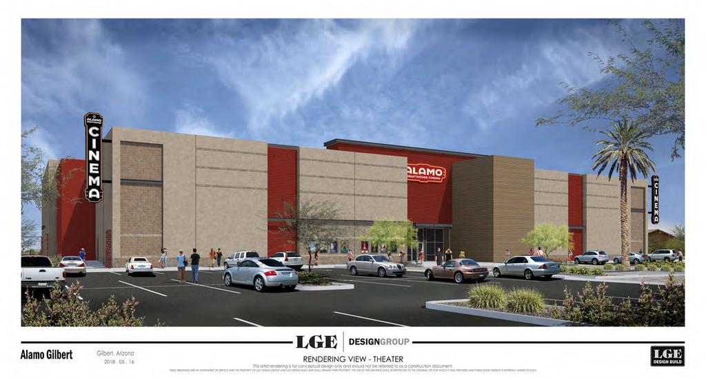
1 New Restaurant & Retail Available S/SWC Power Rd & Ray Rd Gilbert, AZ OPENING Q1 019 Available: Rates: ±1,00 SF up to 8,000 SF, drive-thru pad Please call Demograhics: 1 Mile 3 Miles 5 Miles 018 Population 8,397 69,356 1, Population 9,375 79,614 37, Avg HH Income $91,380 $101,641 $99,318 Comments: New construction adjacent to two large power centers anchored totaling ±710,000 SF GLA of national retail/ restaurants (<1% vacant). New construction end caps and drivethru opportunity. Great street exposure available. Loop 0 access. At The Intersection: Traffic Counts: N: ±30,800 VPD (NB & SB) S: ±6,100 VPD (NB & SB) E: ±9,300 VPD (EB & WB) W: ±15,689 VPD (EB & WB) *Mesa 015 / Gilbert 015 Loop 0 E: ±50,000 VPD (EB & WB) W: ±48,400 VPD (EB & WB) *ADOT East Camelback Road, Suite 340 Phoenix, Arizona Phone: Fax: Teale Bloom tbloom@pca .com Lance Umble lumble@pca .com The information contained herein has been obtained from sources believed reliable. While we do not doubt its accuracy, we have not verified it and make no guarantee, warranty or representation about it. It is your responsibility to independently confirm its accuracy and completeness. Any projections, opinions, assumptions or estimates used are for example only, and do not represent the current or future performance of the property. The value of this transaction to you depends on tax and other factors which should be evaluated by your tax, financial and legal advisors. You and your advisors should conduct a careful, independent investigation of the property to determine to your satisfaction the suitability of the property for your needs. [35] JAN, 019

2
3 1. EXISTING PRIVATE DRIVE TO REMAIN.. EXISTING DRIVE ENTRY TO REMAIN. 3. EXISTING SIDEWALK TO REMAIN. 4. EXISTING LANDSCAPE AREA TO REMAIN. 5. EXISTING STREET LIGHT TO REMAIN. 6. NOT USED. 7. ENHANCED DRIVE W/ STAMPED ASPHALT PAVING TO MATCH EXISTING. 8. ENHANCED CONCRETE CROSSWALK PAVING FLUSH WITH DRIVE, COLOR/FINISH TO MATCH EXISTING, SEE CIVIL DWGS. 9. ASPHALT PAVING IN ALL PARKING AREAS, SEE CIVIL DWGS. 10. PAINTED PARKING STALL STRIPING. 11. LANDSCAPE AREA, SEE LANDSCAPE DWGS. 1. "FUTURE PAD" AREA TO BE PROVIDED WITH DUST PROOFING, SEE LANDSCAPE DWGS " CONCRETE CURB, SEE CIVIL DWGS. 14. CONCRETE SIDEWALK W/ ACID WASH & SALT FINISH. 15. CONCRETE HARDSCAPE W/ ACID WASH & SALT FINISH. 16. NOT USED. 17. NOT USED. 18. ACCESSIBLE ROUTE SHOWN DASHED. 19. ADA COMPLIANT ACCESSIBLE RAMP, SEE DETAILS 05/A ACCESSIBLE PARKING STALL, SEE DETAIL 01/A NOT USED.. EXISTING FIRE HYDRANT. 3. FIRE HYDRANT. 4. FIRELANE- 6-FEET WIDE MINIMUM, 14-FEET MINIMUM VERTICAL CLEARANCE, 35-FOOT MINIMUM TURNING RADIUS. 5. BUILDING MOUNTED F.D.C. 6. FIRE RISER. 7. KNOX BOX LOCATION. 8. 3'-4" HIGH MASONRY SITE SCREEN WALL, SEE DETAIL 16/A MASONRY REFUSE ENCLOSURE W/ 6-FOOT HIGH MASONRY WALL, SEE DETAIL 06/A NOT USED. 31. ELECTRICAL TRANSFORMER ON CONC. PAD, SEE ELECT. DWGS. 3. S.E.S., SEE ELECTRICAL DWGS. 33. POLE MOUNTED LIGHT FIXTURE, SEE DETAIL 10/A0.4 AND ELECTRICAL DWGS. 34. NOT USED. 35. LOCATION OF MONUMENT SIGN (N.I.C.), MONUMENT SIGN UNDER SEPARATE REVIEW/APPROVAL/PERMIT. 36. "R3-5" RIGHT TURN ONLY SIGN " STOP SIGN. BUILDING CODES: 01 INTERNATIONAL BUILDING CODE 01 INTERNATIONAL MECHANICAL CODE 01 UNIFORM PLUMBING CODE 01 INTERNATIONAL FIRE CODE 006 INTERNATIONAL ENERGY CONSTRUCTION CODE 01 INTERNATIONAL ENERGY CONSTRUCTION CODE AS A VOLUNTARY CODE 01 INTERNATIONAL FIRE CODE 011 NATIONAL ELECTRICAL CODE 010 A.D.A. STANDARDS FOR ACCESSIBLE DESIGN INCLUDING ALL TOWN OR GILBERT AMENDMENTS AND ORDINANCES A. REPLACE/REPAIR ANY EXISTING DAMAGED OFFSITE RIGHT-OF-WAY SIDEWALK AND/OR CURBS WITH NEW CONSTRUCTION TO MATCH EXISTING. A. G.C. TO COORDINATE WITH THE FIRE MARSHAL AND PROVIDE FIRE LANE NO PARKING SIGNS AND/OR RED PAINTED CURBS ALONG ALL FIRE LANES AT ALL LOCATIONS REQUIRED IN THE TOWN OF GILBERT FIRE DEPARTMENT SUPPLEMENTAL RULES AND REGULATIONS #1-D103.6R. B. FIRE LANE TURNING RADIUS: 35-FEET MINIMUM INSIDE RADIUS, 55-FEET MINIMUM OUTSIDE RADIUS. FIRE LANE WIDTH: 6-FEET WIDE MINIMUM. C. FIRE RISER ROOM SHALL HAVE IDENTIFICATION SIGNAGE PER TOWN OF GILBERT REQUIREMENTS, G.C. TO COORDINATE WITH FIRE MARSHAL. PROJECT ADDRESS: 5498 S. POWER ROAD - GILBERT, AZ 8595 BUILDING 1 ADDRESS: 5498 S. POWER ROAD - GILBERT, AZ 8595 BUILDING ADDRESS: 5484 S. POWER ROAD - GILBERT, AZ 8595 DEVELOPER: ARCHITECT: LGE DESIGN BUILD 740 NORTH 5ND STREET PHOENIX, AZ LGE DESIGN GROUP 740 NORTH 5ND STREET PHOENIX, AZ BEN McRAE - PROJECT DIRECTOR benm@lgedesigngroup.com PROJECT SCOPE: NEW COMMERCIAL MIXED USE RETAIL CENTER ASSESSOR PARCEL NO.: X CURRENT ZONING: BP NET SITE AREA: 78,83 S.F. (1.79 AC.) LANDSCAPE AREA: 51,634 S.F. (1.0 AC.) LOT COVERAGE: 10.1% 740 N. 5nd Street Phoenix, AZ P: BUILDING 1: STORIES: BUILDING AREA S.F.: COVERED PATIO S.F.: OCCUPANCY: CONSTRUCTION TYPE: ONE STORY (+4'-0" A.F.F.) 8,737 S.F.,097 S.F. M V-B W/ A.F.E.S. BUILDING : NOT A PART ZONING BP ZONING BP NOT A PART STORIES: ONE STORY (+4'-0" A.F.F.) BUILDING AREA S.F.: 4,168 S.F. COVERED PATIO S.F.: 1,481 S.F. OCCUPANCY: M CONSTRUCTION TYPE: V-B W/ A.F.E.S. TOTAL BUILDING 1 & AREA S.F.: 1,905 S.F. REQUIRED PARKING CALCS: SQUARE FT. FACTOR TOTAL ENTIRE SITE 1,905 S.F. 1 / 00 S.F. 65 SPACES ZONING BP NOT A PART ' '-6" O.H '-6" 140'-0" BUILDING TO LOT LINE 9 54'-0" 14'-4" 7'-0" 34'-7" 6'-0" FIRE LANE 6'-0" 16'-10" 7'-0" 13'-0" 36'-0" 6'-0" LIMITS OF CONSTRUCTION '-6" 16'-6" 6'-6" '-3" 9 0'-0" '-6" 16'-6" 0'-0" '-0" '-6" BUILDING 1 8,737 S.F. 5'-0" BUILDING & LANDS. SETBACK 70'-0" R.O.W. 5 5'-0" EXCEPTED PARCEL 7 10'-10" '-4" 6' 0'-4" 9 3 BUILDING 4,168 S.F '-0" BUILDING & LANDS. SETBACK 16'-6" BUILDING TO PROP.LINE 45'-0" TEMP. DRAINAGE EASEMENT 1'-0" WATER EASEMENT FUTURE PAD 63'-0" 11' 6' 11' 36'-0" 5' 7'-0" 6' 7' 6' 50'-0" 7'-0" 11' 5' 11' 99'-7" 6' 13'-5" 36'-0" 6'-0" 6'-0" FIRE LANE 7 FIRE LANE 63'-0" 6' 7'-0" 6' 36'-0" 14'-8" 14'-8" 36'-0" 6' 54'-0" 54'-0" 6' 6' 54'-0" 3 6'-0" '-6" 16'-6" '-0" 9' 11 41'-8" BUILDING TO LOT LINE 16'-6" BUILDING TO PROP.LINE 9 FIRE LANE 45'-0" 6' 63'-0" 8' ' 16'-0" BUILDING TO BUILDING 41'-8" BUILDING TO LOT LINE 19 14'-3" 50'-0" 11'-" 6' 7'-4" 8' 7'-0" 6'-4" 18'-0" 0'-0" '-0" 11 6' 3'-0" 6' 11'-0" 6' 7 0'-0" 7 5'-6" 16'-6" 9' 9' 45 18'-0" '-6" 16'-6" '-6" 16'-6" 6'-0" 31 VAN 9' '-0" FIRE LANE 3 93'-0" 1 194'-0" BUILDING TO LOT LINE UNDER SEPARATE PERMIT S. POWER ROAD 133'-0" 5 4 FIRE LANE '-0" 6' 7'-0" 13'-3" 6'-0" '-6" '-6" O.H. 11 0'-0" B.S.L. L.S. 1 EXISTING COMMON DRIVE ZONING RC EXISTING ADJACENT DEVELOPMENT PARKING PROVIDED TOTAL REGULAR SPACES TOTAL ACCESSIBLE SPACES TOTAL SPACES PARKING RATIO E. RAY RD S. POWER RD 14 SPACES 10 SPACES 4 SPACES 65 SPACES 9.90 CARS FOR 1,000 S.F. ACCESSIBLE PARKING CALCULATION: TOTAL ACCESSIBLE SPACES REQUIRED 5 SPACES TOTAL ACCESSIBLE SPACES PROVIDED 4 SPACES TOTAL ACCESSIBLE SPACES FUTURE **1 SPACES TOTAL ACCESSIBLE SPACES 5 SPACES ** NOTE: DEVELOPMENT OF FUTURE PAD TO INCLUDE A MINIMUM OF 1 ACCESSIBLE SPACE (NEAR MAIN ENTRY) OR AS REQUIRED BASED ON OVERALL ADJUSTED FUTURE PARKING TOTAL. THIS PROJECT CONSISTS OF TWO MULTI-TENANT COMMERCIAL RETAIL BUILDINGS AND A FUTURE PAD. THE DESIGN OF THESE BUILDINGS CONSIST OF SEVERAL DIFFERENT TYPE OF CONCRETE WALLS, EIFS, METAL PANELS, AND BRICK VENEER PLACED TO PROVIDE AN AESTHETIC TEXTURE AND INTEREST WHILE COMPLIMENTING THE EXPOSED STEEL STRUCTURE THAT SUPPORTS THE UNIQUELY DESIGNED ENTRIES. THERE ARE GENEROUS LANDSCAPE AREAS SURROUNDED BY PEDESTRIAN HARDSCAPES THAT TIE THE PROJECT TOGETHER WITH FUTURE DEVELOPMENTS. DRIVES ARE PROVIDED WITH ACCENTED ENTRIES FOR A SENSE OF ARRIVAL TO THE SITE. ALL THE UTILITIES WILL BE AT THE REAR OF THE BUILDINGS AND FULLY SCREENED. S. SOSSAMAN RD NUMBER REVISION DATE CITY COMMENTS 1ST REVIEW PROJECT LOCATION SHEET TITLE: SITE PLAN EXISTING DEVELOPMENT ZONING C- EXISTING DEVELOPMENT ZONING LC E. GALVESTON ST. GILBERT HOSPITAL ISSUE DATE: DRAWN BY: CHECKED BY: PROJECT No.: MLK VJD SITE PLAN SCALE: 1/3" = 1'-0" SHEET:
4

5
6

7

8


9 AERIAL ±48,400 VPD ±50,000 VPD ±30,800 VPD ±30,800 VPD S/SWC Power Rd & Ray Rd Gilbert, AZ ±9,300 VPD POWER RD GILBERT GATEWAY TOWNE CENTER RAY RD ±6,100 VPD ±15,689 VPD SANTAN VILLAGE Loop 0 & Williams Field Rd GILBERT, AZ PHOENIX COMMERCIAL ADVISORS N This map was produced using data from private and governmental sources deemed to be reliable. The information is provided without representation or warranty.

 4173 STU COOLEY STATION - SOUTH 00 UNITS WILLIAMS FIELD RD HIGHLAND RIDGE 800 UNITS WARNER RD COOLEY STATION 106 UNITS 0 6 5 SIGNAL BUT TE RD GUADALUPE RD PHOENIX-MESA")
10 S/SWC Power Rd & Ray Rd Gilbert, AZ HIGHLAND HIGH SCHOOL 3091 STU MULBERRY 1094 UNITS GUADALUPE RD VAL VISTA DR AERIAL SUNLAND SPRINGS EAST 3300 UNITS LA ALDEA 35 UNITS HIGLEY RD ELLSWORTH RD SOSSAMAN RD MORRISON RANCH 546 UNITS WARNER RD ELLIOT RD POWER RD GREENFIELD RD ELLIOT RD EASTMARK UNITS COPPER RANCH 459 UNITS CASCADE 35 UNITS RECKER RD HIGLEY PARK 611 UNITS GILBERT GATEWAY TOWNE CENTER WILLIAMS FIELD HIGH SCHOOL 1871 STU LYONS GATE 164 UNITS BELLA VIA 600 UNITS RAY RD RAY RD THE WILLOWS 586 UNITS SANTAN VILLAGE GATEWAY 100 UNITS ARIZONA STATE UNIVERSITY (POLYTECHNIC) 4173 STU COOLEY STATION - SOUTH 00 UNITS WILLIAMS FIELD RD HIGHLAND RIDGE 800 UNITS WARNER RD COOLEY STATION 106 UNITS SIGNAL BUT TE RD GUADALUPE RD PHOENIX-MESA GATEWAY AIRPORT POWER RD D AN R AM SS HIGLEY HIGH SCHOOL PECOS MANOR 1683 STU 56 UNITS MPC/Housing Data SO HIGLEY RD SANTAN VILLAGE MARKETPLACE "Active" "Future" PECOS RD STRATLAND ESTATES 857 UNITS Power Rd & Ray Rd GILBERT, AZ GERMANN RD 700- acre plot of land Mixed use - Industrial, Commercial, and Residential Provides 10,000+ jobs Brings in $1.3 billion annually Last year,,000 landings and takeoffs makes Gateway busier than Portland International Airport East Valley itself is a market Near Apple s $ billion data center Y KW US EP SOMERSET 86 UNITS RAN CAMPO VERDE HIGHGATEWAY SCHOOL GILBERT 089 STU GREENFIELD RD N Future Development WHITEWING AT HIGLEY 151 UNITS H CH O PHOENIX COMMERCIAL ADVISORS LA JARA FARMS This map was produced using data from private and governmental sources deemed GERMAN SHEA HOMES (018)to be reliable. The information is provided without representation or warranty. N RD

11

12


 classifies Phoenix-Mesa Gateway Airport as a non-hub commercial service airport.")
 Runway 1R-30L: 10,401 x 150 ) Runway 1C-30C: 10,01 x 150 3) Runway 1L-30R: 9,301")
13 Located in the East Valley of the Phoenix Metropolitan Area, Phoenix-Mesa Gateway Airport is a former military airfield that has successfully made the transition to a full service commercial passenger airport. Regularly scheduled commercial service began in October of 007 with initial service from Allegiant Air to 13 destinations. As of January 009, a total of 15 destinations are supported. Allegiant Air accounted for 174,50 enplanements in calendar year 008. An additional 3,399 enplanements were realized from air taxi and charter operations. Approximately 355,000 passengers utilized the airport in 008. Phoenix-Mesa Gateway Airport is operated and maintained by the Williams Gateway Airport Authority (WGAA), a Joint Powers Airport Authority comprised of the Cities of Mesa and Phoenix, the Towns of Queen Creek and Gilbert, and the Gila River Indian Community. The Airport Authority was formed to develop, reuse, operate, and maintain the airport property and facilities at the former Williams Air Force Base, which closed in September Initially operated as a reliever general aviation airport, Phoenix-Mesa Gateway Airport now provides regularly scheduled commercial passenger air service in its own right. In this capacity, the airport provides a much needed alternative for passengers who might otherwise utilize busy Phoenix Sky Harbor International Airport. The Federal Aviation Administration (FAA) classifies Phoenix-Mesa Gateway Airport as a non-hub commercial service airport. The airport has over 100 based general aviation aircraft, including many business aircraft owned or leased by corporations and major employers in the metropolitan area. The following are the major facilities at Phoenix-Mesa Gateway Airport: Three parallel commercial capable runways: 1) Runway 1R-30L: 10,401 x 150 ) Runway 1C-30C: 10,01 x 150 3) Runway 1L-30R: 9,301 x 150 Airport traffic control tower. 33,000 sq. ft. terminal building with 4 gates. 33,000 sq. yd. aircraft parking apron. Over 30,000 sq. yd. cargo ramp. Full-service fixed base operator and other specialty operators. Four business jet service centers (Embraer, Cessna, Hawker Beechcraft, and Crownair) MASTER PLAN PREPARATION The Phoenix-Mesa Gateway Airport Master Plan is the second update to the original master plan undertaken in 1994 and first updated in Proactive airport sponsors will periodically update their airport s master plan to ensure that the airport can continue to adapt to developments in the local and national aviation economies. Updates every five to seven years are particularly important at Phoenix-Mesa Gateway Airport as it has evolved from a military airfield to a public commercial service airport. This study was financed with assistance from the FAA. The Phoenix-Mesa Gateway Airport Master Plan is of interest to many within the local community. This includes local citizens, community organizations, airport users, airport tenants, area-wide planning agencies, and aviation organizations. To assist in the coordination and development of the Master Plan, the Williams Gateway Airport Authority identified a cross-section of these persons and groups to serve on a Planning Advisory Committee (PAC). The committee met six times over the course of the study to review and discuss draft working chapters of the master plan. In addition, four public information workshops were held to provide information to and solicit input from other interested citizens. One workshop was held in the Town of Gilbert, one in the Town of Queen Creek, and the remaining two were held at the airport. The same draft working papers that were provided to the PAC were also made accessible to the public via the consultant and airport web sites. DEMAND-BASED PLANNING Facility planning begins with a definition of demand that may reasonably be expected in the future. For Phoenix-Mesa Gateway Airport, this involved updating forecasts to identify potential future aviation demand. Recognizing the realities of year-to-year fluctuations in activity, the Master Plan is keyed to potential demand levels rather than specific future dates in time. These planning horizons were established as levels of aviation activity that, when reached, trigger consideration by airport management of the next step in the Master Plan program. By developing the airport to meet the aviation demand as those indicators are reached instead of specific points in time, the airport will be able to implement development needs which will meet the operational demands of its users in a cost-efficient and well-planned manner. This program also provides the Airport Authority the flexibility to accelerate or delay project implementation based on actual need or unanticipated changes in needs or demand. The forecast planning horizons are summarized in the accompanying table. Planning Horizon Enplanements Air Carrier Operations Air Cargo Operations Air Taxi Operations Military Operations General Aviation Operations Total Operations Enplaned Air Cargo (Tons) Based Aircraft * 008 Enplanement Short Intermediate Long Baseline Term Term Term ,649* 1, ,675 9,380 76,670 96, ,000 9, ,77 1,500 31, ,000 10, AIRPORT IMPROVEMENT PLAN Several significant changes and events have occurred since the completion of the 1999 Master Plan Update. First, the terrorist attacks of September 11, 001 utilizing commercial airplanes, placed an economic and security strain on the aviation industry. At the time, Phoenix-Mesa Gateway Airport was positioned to welcome commercial passenger service. These events directly contributed to airlines shifting priorities away from expansion. Second, the City of Phoenix was officially given a seat on the Board of Directors. Third, the launch of regularly scheduled commercial service in October 007 has led to a need to reconsider the development priorities of the airport. Fourth, from a socioeconomic standpoint, the East Valley region has continued to grow substantially, often leading the nation in some growth measures. Finally, airport design standards as developed by the FAA have gone through nine different revisions since the completion of the previous master plan. With consideration of these factors a new master plan concept was developed. The new concept preserves all three runways as potential commercial service runways. Runway 1L-30R would be the primary commercial passenger departure runway, Runway 1C-30C would be the primary arrival runway, and Runway 1R-30L would be the general aviation and air cargo runway. The recommended airfield layout was developed in a fashion that would minimize or eliminate the need for additional property acquisition or surface road alterations. 850,000 0,806 1,700 16,171 1, ,83 415,000 1,000 41,00,000 48,166 3,500,866 1, , ,000 44, This was accomplished without any negative impact to current or future operations. The taxiway system was redesigned to meet an FAA recommendation that increases safety by reducing the potential for runway incursions. This redesign creates staggered taxiway exits from the runways that reduce the possibility of an aircraft crossing the runways without being forced to make turns.

14


15 The west side ramp is separated into functional uses. The north ramp is primarily for use by general aviation aircraft. The middle ramp is primarily for use by commercial passenger aircraft, and the south ramp is primarily utilized by airport maintenance businesses and corporate hangar facilities. This division of activity levels is planned to be maintained until such a time that the commercial service facilities are relocated to the east side of the airport. The southwest portion of the airport has over 30 acres of undeveloped property. This area is planned to support both aviation related businesses (those needing taxiway access) and non-aviation businesses (those not needing taxiway access). A new taxiway is planned to open up this area for aviation related business development. This area provides unique development opportunities as the availability of large parcels at major metropolitan airports is rare. With enplanements (passenger boardings) forecast to reach. million within 0 years and potentially 5 million beyond that, development of the east side of the airport with a replacement passenger terminal is recommended. Based on recent enplanement growth trends, the need for more capacity in the passenger terminal building is immediate. The entire flight line on the east side of the airport is reserved for passenger terminal complex expansion. INTERMEDIATE TERM IMPROVEMENTS Initial construction of the east side terminal building East side aircraft ramp East side fuel farm and other support facilities Extension of Runway1L approximately 1,000 feet to the northwest Relocation of Taxiway G to eliminate the diagonal nature of the existing taxiway East side road construction Alpha apron expansion New approach lights leading to Runway 30C Additional vehicle parking (surface and/or multi-story garage) LONG TERM IMPROVEMENTS Expansion of the east side terminal building New taxiway construction Alpha apron expansion Runway 1R-30L extension southeast Reconstruction of general aviation apron East side ARFF facilities East side parking garage Runway 1R-30L reconstruction The Arizona Department of Transportation (ADOT) Aeronautics Division provides.5 percent matching funding on federal grants. ADOT has several additional grant and loan programs available to airport sponsors. The member governments of the Airport Authority Board have also extended long term loans to the airport. The airport also generates revenues on its own through facility rentals and land leases. As a commercial service airport, Phoenix-Mesa Gateway Airport is eligible to impose a passenger facility charge of $4.50 per ticket to be used for specific airport improvements. The table outlines the total funding program for the master plan. Projects directly associated with development of the east side terminal complex are estimated to cost approximately $34 million of the $755 million total. Approximately $401 million of the total costs will be eligible for grants-in-aid administered by the FAA. Approximately $11. million is eligible for state aid, and the remaining $34 million would be the responsibility of the airport. Project eligibility does not guarantee funding. CAPITAL FUNDING PLAN (008) Planning Horizon Short Term Intermediate Term Long Term Totals Project Cost $59,865,000 $35,49,000 $59,333,000 $754,67,000 FOR MORE INFORMATION, PLEASE CONTACT: Phoenix-Mesa Gateway Airport 5835 South Sossaman Road Mesa, Arizona Phone: Fax: website: FAA Eligible ADOT Eligible $191,186,550 $5,661,5 $74,775,450 $1,967,775 $135,331,300 $3,561,350 $401,93,300 $11,190,350 Local Share $63,017,5 $158,685,775 $10,440,350 $34,143,350 As airports are rapidly becoming multi-functional businesses, those areas on the east side that are not reserved for direct aviation related activities are planned for commercial development. The types of development should be keyed to the aviation nature of the facility such as hotels, a convention center, restaurants, and shops. The major development items anticipated for each planning horizon are summarized as follows: ECONOMIC IMPACT As part of the Master Plan study, an Economic Benefit Study of the airport was conducted. The presence of the airport created both tangible and intangible benefits for the airport service area. The airport supports a diverse range of aviation and non-aviation activity. The airport has attracted essential services to the region, including enhanced medical care, such as air ambulance service, support for law enforcement, and air cargo services. In quantifying benefits generated by airports, economists have emphasized indicators of economic activity such as dollar value of output (revenue), number of jobs created (employment), and earnings of workers and business owners (earnings). The total economic benefit (including all multiplier effects) of the Phoenix-Mesa Gateway Airport was $534.6 million in 007/008, supporting 4,075 jobs in the service area. The following summarizes the economic benefits of the airport currently: SHORT TERM IMPROVEMENTS Expansion of the west side passenger terminal and vehicle parking capacity Alpha apron expansion Completion of the dual west side taxiway system Major Rehabilitation of Runway 1C-30C Construction of Taxiway L across the airfield and into the undeveloped southwest parcels Significant drainage and other infrastructure improvements Rehabilitation of portions of Runway 1R-30L Completion of east side parallel Taxiway C Perimeter service road improvements East side terminal complex planning studies Acquisition of 31 acres on the east side CAPITAL IMPROVEMENT FUNDING The full implementation of the Master Plan would involve a financial commitment of $755 million over the planning period. Financing for capital improvements can come from several sources. The FAA administers the federal Airport Improvement Program (AIP) that provides up to 95 percent funding for eligible capital projects. Funding for this program comes from Congressional appropriations of revenues generated by airport users. This includes taxes on airline tickets, aviation fuel, aircraft registrations, and other aviation related sources. The airport has also benefited from its inclusion in the Military Airport Program, which is a federal set aside of AIP grant funds for aiding conversion of former military airfields to civilian use. DIRECT BENEFITS: Created by suppliers of aviation services located on the airport. $01.3 Million Revenues $73.4 Million Earnings 1,51 On-Airport Jobs INDIRECT BENEFITS: Created by air visitors utilizing Phoenix-Mesa Gateway Airport. $36.6 Million Revenues $13.3 Million Earnings 57 Off-Airport Jobs INDUCED BENEFITS: Created by multiplier effects as spending reticulates within the regional economy. $96.7 Million Revenues $11.5 Million Earnings,97 Jobs TOTAL ECONOMIC IMPACTS: The sum of Direct, Indirect, and Induced Impacts. $534.6 Million Revenues $09. Million Earnings 4,074 Jobs
16 ALPHA APRON Airport Consultants


17 Population Summary One Page Summary Power Rd & Ray Rd, Gilbert Prepared By Business Analyst Desktop Latitude: Rings: 1, 3, 5 mile radii Longitude: mile 3 miles 5 miles 000 Total Population 636 9,7 71, Total Population 6,833 48, , Total Population 8,397 69,356 1, Group Quarters Total Population 9,375 79,614 37, Annual Rate.3%.80%.18% 018 Total Daytime Population 7,70 46, ,70 Workers 3,40 1,393 61,67 Residents 4,030 34,71 109,453 Household Summary 000 Households 18,977 3, Average Household Size Households,189 15,57 55, Average Household Size Households,583 1,985 70, Average Household Size Households,884 5,04 78, Average Household Size Annual Rate.3%.77%.15% 010 Families 1,605 1,09 43, Average Family Size Families 1,887 16,955 53, Average Family Size Families,097 19,369 59, Average Family Size Annual Rate.13%.70%.05% Housing Unit Summary 018 Housing Units,687,818 75,851 Owner Occupied Housing Units 69.7% 73.6% 69.6% Renter Occupied Housing Units 6.5%.8% 3.8% Vacant Housing Units 3.9% 3.7% 6.6% Median Household Income 018 $80,1 $86,8 $8, $90,143 $99,393 $9,467 Median Home Value 018 $16,053 $4,864 $6, $50,359 $84,306 $98,636 Average Income Value Average Household Income $91,380 $101,641 $99,318 Per Capita Income 018 $9,144 $3,900 $33,18 03 $34,537 $38,808 $38,814 Median Age Population 5+ by Educational Attainment Total 4,769 40,695 13,15 Less than 9th Grade.0% 1.5% 1.9% 9th - 1th Grade, No Diploma 1.3%.6% 3.% High School Graduate 13.0% 13.7% 16.0% GED/Alternative Credential.%.%.3% Some College, No Degree 9.% 6.4% 6.4% Associate Degree 9.1% 10.6% 9.7% Bachelor's Degree 9.8% 9.5% 7.4% Graduate/Professional Degree 13.3% 13.5% 13.1% Data Note: Household population includes persons not residing in group quarters. Average Household Size is the household population divided by total households. Persons in families include the householder and persons related to the householder by birth, marriage, or adoption. Per Capita Income represents the income received by all persons aged 15 years and over divided by the total population. Source: U.S. Census Bureau, Census 010 Data. Esri forecasts for 018 and 03 October 1, 018 Made with Esri Business Analyst 018 Esri Try it Now! Page 1 of 1
Westover Metropolitan Airport Master Plan Update
 Westover Metropolitan Airport Master Plan Update June 2008 INTRODUCTION Westover Metropolitan Airport (CEF) comprises the civilian portion of a joint-use facility located in Chicopee, Massachusetts. The
ROYAL VIEW DEVELOPMENT
 GRETNA BUILDING FOR LEASE ROYAL VIEW DEVELOPMENT PROPOSED RENDERINGS AVAILABLE FOR PRE-LEASE + + LEASE RATE AND AVAILABILITY MINIMUM SPACE: MAXIMUM SPACE: LEASE RATE: 1,278 SF 16,500 SF $16.50 - $22.00
For Sale: Prime Gilbert/Gateway Property
 Development/Investment Opportunity For Sale: Prime Gilbert/Gateway Property Offering Highlights Lance Richards Broker Approximately 56 Acres Parcels & Pads Sized from.75 to 17.5 Acres Town of Gilbert Zoning
CHAPTER 1 EXECUTIVE SUMMARY
 CHAPTER 1 EXECUTIVE SUMMARY 1 1 EXECUTIVE SUMMARY INTRODUCTION William R. Fairchild International Airport (CLM) is located approximately three miles west of the city of Port Angeles, Washington. The airport
Preferred Alternative Summary
 Tacoma Narrows Airport Master Plan Update Preferred Alternative Summary The Preferred Alternative represents Pierce County s vision for the long-term development of the Tacoma Narrows Airport. This Alternative
STUDY OVERVIEW MASTER PLAN GOALS AND OBJECTIVES
 INTRODUCTION An Airport Master Plan provides an evalua on of the airport s avia on demand and an overview of the systema c airport development that will best meet those demands. The Master Plan establishes
MOON VALLEY TOWNE CENTER
 SEC 7th St & Bell Rd Phoenix, AZ Join SHOP SPACE AVAILABLE FOR LEASE SEC 7th St & Bell Rd Phoenix, AZ PROPERTY DETAILS Join Hobby Lobby, Tutor Time, and a brand new Marshalls, with Michaels coming soon
6.0 Capital Improvement Program. 6.1 Capital Improvement Plan (CIP)
") 6.0 The addresses the phased scheduling of projects identified in this Master Plan and their financial implications on the resources of the Airport and the City of Prescott. The phased Capital Improvement
6.0 The addresses the phased scheduling of projects identified in this Master Plan and their financial implications on the resources of the Airport and the City of Prescott. The phased Capital Improvement
ANNECY EXCLUSIVE LISTING GILBERT, ARIZONA
 ANNECY EXCLUSIVE LISTING GILBERT, ARIZONA LOCATION Property is located S/SEC of ive and Williams Field Road in Gilbert, Arizona PRICE Submit LOTS 311 Finished Row Lots ZONING MF/L HOA Designated Builder
3707 E Southern Ave 3707 E. Southern Ave., Mesa, Arizona 85208
 For Lease Class B Office Building Up To 59,301 SF 3707 E Southern Ave 3707 E. Southern Ave., Mesa, Arizona 85208 Property Features Entire building (± 59,301 SF) available for single-user tenant Floor 1
Finance and Implementation
 5 Finance and Implementation IMPLEMENTATION The previous chapters have presented discussions and plans for development of the airfield, terminal, and building areas at Sonoma County Airport. This chapter
Addendum - Airport Development Alternatives (Chapter 6)
") Bowers Field Addendum - Airport Development Alternatives (Chapter 6) This addendum to the Airport Development Alternatives chapter includes the preferred airside development alternative and the preliminary
Bowers Field Addendum - Airport Development Alternatives (Chapter 6) This addendum to the Airport Development Alternatives chapter includes the preferred airside development alternative and the preliminary
Punta Gorda Airport Master Plan Update
 Punta Gorda Airport Master Plan Update Draft Executive Summary Prepared for: The Charlotte County Airport Authority January 2018 Charlotte County Airport Authority James Herston, Chair Robert D. Hancik,
Airport Planning Area
 PLANNING AREA POLICIES l AIRPORT Airport Planning Area LOCATION AND CONTEXT The Airport Planning Area ( Airport area ) is a key part of Boise s economy and transportation network; it features a multi-purpose
FORECASTING FUTURE ACTIVITY
 EXECUTIVE SUMMARY The Eagle County Regional Airport (EGE) is known as a gateway into the heart of the Colorado Rocky Mountains, providing access to some of the nation s top ski resort towns (Vail, Beaver
Chapter 2 FINDINGS & CONCLUSIONS
 Chapter 2 FINDINGS & CONCLUSIONS 2.01 GENERAL Dutchess County acquired the airport facility in 1947 by deed from the War Assets Administration. Following the acquisition, several individuals who pursued
Chapter 1: Introduction
 Chapter 1: TABLE OF CONTENTS 1... 4 1.1 Master Plan Study Content... 4 1.2 Purpose and Scope of Master Plan Study... 4 1.3 Airport History and Role... 6 1.4 Airport Location and Service Area... 6 1.5 ABIA
Wyoming Valley Airport Proposed Improvements. Presented June 26, 2012 By The WBW Airport Advisory Board & FBO
 Wyoming Valley Airport Proposed Improvements Presented June 26, 2012 By The WBW Airport Advisory Board & FBO Contents Purpose of meeting Airport overview Background of proposed improvements SWOT analysis
Fiesta Commons Shopping Center
 Fiesta Commons Shopping Center NEC OF SOUTHERN AVE & ALMA SCHOOL RD, MESA, AZ PROPERTY SIZE: 163,420 Sq. Ft. Great Infill Property across the street from Fiesta Regional Mall, Bank of America Tower, Carrington
RESOLUTION NO
 RESOLUTION NO. 2015-15 A RESOLUTION OF THE CITY COUNCIL OF THE CITY OF MARINA AUTHORIZING SUBMISSION OF A GRANT APPLICATION TO THE FEDERAL AVIATION ADMINISTRATION (FAA) FOR PARTICIPATION IN THE 2015 MILITARY
Chapter 1: Introduction Draft
 Chapter 1: Draft TABLE OF CONTENTS 1... 4 1.6.1 Stakeholder Engagement Plan... 10 Chapter 1 Page 2 TABLE OF EXHIBITS Exhibit 1.1-1 ABIA Annual Growth Since 1993... 5 Exhibit 1.4-1: ABIA Location Map...
Chapter Seven COST ESTIMATES AND FUNDING A. GENERAL
 Chapter Seven COST ESTIMATES AND FUNDING A. GENERAL This chapter delineates the recommended 2005 2024 Sussex County Airport Capital Improvement Program (CIP). It further identifies probable construction
Table of Contents. Overview Objectives Key Issues Process...1-3
 Table of Contents Chapter One Introduction Overview...1-1 Objectives...1-1 Key Issues...1-2 Process...1-3 Chapter Two Inventory of Existing Conditions Airport Setting...2-1 Locale...2-1 Airport Surroundings...2-5
Airport Master Plan Update June 15, 2017
 Airport Master Plan Update June 15, 2017 www.harveyfield.com The Master Plan is a 20-year plan to understand the needs of current and future users of the Airport. This is important to ensure that safe
Fort Wayne International Airport Master Plan Study. Executive Summary
 Fort Wayne International Airport Master Plan Study Executive Summary March 2012 Introduction Airport Background Forecast of Aviation Activity Development Plans Recommended Airfield & Access Development
Airport Master Plan Update June 15, 2017
 Airport Master Plan Update June 15, 2017 www.harveyfield.com The Master Plan is a 20-year plan to understand the needs of current and future users of the Airport. This is important to ensure that safe
Executive Summary. MASTER PLAN UPDATE Fort Collins-Loveland Municipal Airport
 Executive Summary MASTER PLAN UPDATE Fort Collins-Loveland Municipal Airport As a general aviation and commercial service airport, Fort Collins- Loveland Municipal Airport serves as an important niche
 Existing Conditions AIRPORT PROFILE Passenger Terminal Complex 57 air carrier gates 11,500 structured parking stalls Airfield Operations Area 9,000 North Runway 9L-27R 6,905 Crosswind Runway 13-31 5,276
Current and Forecast Demand
 Existing Facilities Jacksonville International Airport (JIA) is served by a number of airside and landside facilities. There are two runways that serve the airport in an open V configuration. The Annual
AIRPORT FUND. Description. Summary
 Description In March 1941 construction started for the airport at its present site. After Pearl Harbor, the airport, known as Pinellas Army Airfield, was used as a military flight-training base. After
CHAPTER 1: INTRODUCTION
 CHAPTER 1: INTRODUCTION Purpose and Scope The information presented in this report represents the study findings for the 2016 Ronan Airport Master Plan prepared for the City of Ronan and Lake County, the
City of Redding Airports
 City of Redding Airports Benton Airpark Redding Municipal Airport DEVELOPMENT AND USE GUIDELINES FOR GENERAL AVIATION HANGARS April 7, 2009 PREFACE The City of Redding, as owner of federally obligated
Appendix D Project Newsletters. Tacoma Narrows Airport. Master Plan Update
 Appendix D Project Newsletters Tacoma Narrows Airport Master Plan Update This appendix contains the newsletters distributed throughout the project. These newsletters provided updates and information on
Chapter 1 Introduction and Project Overview
 Chapter 1 Introduction and Project Overview Kittitas County in cooperation with the Federal Aviation Administration (FAA) is updating the Airport Master Plan for Bowers Field Airport (FAA airport identifier
Safety, Infrastructure, and Tenant Improvement Project. Public Hearing Informational Brochure February 26, 2013
 New York State Department of Transportation Safety, Infrastructure, and Tenant Improvement Project Public Hearing Informational Brochure February 26, 2013 This DEIS/Draft EA evaluates the potential impacts
HILLSBORO AIRPORT MASTER PLAN UPDATE Planning Advisory Committee Meeting 1
 HILLSBORO AIRPORT MASTER PLAN UPDATE Planning Advisory Committee Meeting 1 Feb. 27, 2017 HILLSBORO AIRPORT MASTER PLAN UPDATE Planning Advisory Committee Welcome Curtis Robinhold, Port of Portland 1 HILLSBORO
PUBLIC NOTICE. Table 1 Projects Proposed by Amendment
 PUBLIC NOTICE The Dallas Department of Aviation (the Department) intends to file an amendment application to increase the PFC amount of one previously approved project at Dallas Love Field Airport (the
Master Plan Update Technical Advisory Committee Meeting
 Nashville International Airport Master Plan Update Technical Advisory Committee Meeting February 14, 2019 Agenda Welcome and Introductions Aviation Activity Forecast Facility Requirements Alternatives
±2.5 ACRES FOR SALE EXCLUSIVE LISTING APACHE JUNCTION, ARIZONA
 ±2.5 ACRES FOR SALE EXCLUSIVE LISTING APACHE JUNCTION, ARIZONA PROPERTY OVERVIEW This ±2.5 acre lot is located at the end of E 34th Avenue and features incredible views of the surrounding mountains. The
CLASS SPECIFICATION 5/12/11 SENIOR AIRPORT ENGINEER, CODE 7257
 Form PDES 8 THE CITY OF LOS ANGELES CIVIL SERVICE COMMISSION CLASS SPECIFICATION 5/12/11 SENIOR AIRPORT ENGINEER, CODE 7257 Summary of Duties: A Senior Airport Engineer performs the more difficult and
Prepared By: Mead & Hunt, Inc Port Lansing Road Lansing, MI 48906
 Master Plan The preparation of this document was financed in part through a planning grant from the Federal Aviation Administration (FAA) as provided under Section 505 of the Airport and Airway Improvement
The presentation was approximately 25 minutes The presentation is part of Working Group Meeting 3
 This is the presentation for the third Master Plan Update Working Group Meeting being conducted for the Ted Stevens Anchorage International Airport Master Plan Update. It was given on Thursday March 7
Kittitas County Airport Bowers Field Airport Master Plan Planning Advisory Committee Meeting #1 April 6, 2016
 Kittitas County Airport Bowers Field Airport Master Plan Planning Advisory Committee Meeting #1 April 6, 2016 Project Team Kittitas County, WA Airport Owner (Sponsor) and Operator, Land Use Century West
2017 Appropriation Budget Table of Contents Board Approved August 19, 2016
 INDIANAPOLIS AIRPORT AUTHORITY 2017 APPROPRIATION BUDGET ORDINANCE NO. 2-2016 BOARD APPROVED AUGUST 19, 2016 2017 Appropriation Budget Table of Contents Board Approved August 19, 2016 1 Appropriation Summary
AIRPORT: Yakima Air Terminal (YKM) ASSOCIATED CITY: Yakima ARC: C-III Region: South Central
 ASSOCIATED CITY: Yakima ARC: C-III Region: South Central") AIRPORT: Yakima Air Terminal (YKM) ASSOCIATED CITY: Yakima ARC: C-III Region: South Central AIRPORT DATA AND FACILITIES is located in Yakima County, three miles south of the City. The Airport has 115 based
AIRPORT: Yakima Air Terminal (YKM) ASSOCIATED CITY: Yakima ARC: C-III Region: South Central AIRPORT DATA AND FACILITIES is located in Yakima County, three miles south of the City. The Airport has 115 based
TABLE OF CONTENTS. General Study Objectives Public Involvement Issues to Be Resolved
 TABLE OF CONTENTS Description Page Number LIST OF ACRONYMS... a CHAPTER ONE INTRODUCTION General... 1-1 Study Objectives... 1-1 Public Involvement... 1-2 Issues to Be Resolved... 1-2 CHAPTER TWO EXISTING
JOSLIN FIELD, MAGIC VALLEY REGIONAL AIRPORT DECEMBER 2012
 1. Introduction The Federal Aviation Administration (FAA) recommends that airport master plans be updated every 5 years or as necessary to keep them current. The Master Plan for Joslin Field, Magic Valley
Yakima Air Terminal/McAllister Field Airport Master Plan Update
 Yakima Air Terminal/McAllister Field Airport Master Plan Update City of Yakima Work Session July 9, 2013 Meeting Goals Summarize the master plan recommendations. Discuss the decision-making process used
Airport Master Plan. Rapid City Regional Airport. October 2015 FAA Submittal
 Airport Master Plan Rapid City Regional Airport October 2015 FAA Submittal Rapid City Regional Airport Master Plan Update Table of Contents Executive Summary... i Scope & Timeline... i Forecasts... i Preferred
SouthwestFloridaInternational Airport
 SouthwestFloridaInternational Airport SouthwestFloridaInternationalAirportislocatedinLee CountyalongtheGulfCoastofSouthFlorida,tenmiles southeastofthefortmyerscentralbusinessdistrict. Theprimaryhighwayaccesstotheairportfrom
AGREEMENT APPLICATION PACKET
 Business Development Office AGREEMENT APPLICATION PACKET 2017 5835 S. Sossaman Road Mesa, AZ 85212 Dear Prospective Applicant: Thank you for your interest in joining the exciting business revolution occurring
Airport Master Plan Open House Front Range Airport February 23, 2017
 Airport Master Plan Open House Front Range Airport February 23, 2017 MASTER PLAN PROCESS AND OVERVIEW MASTER PLAN ELEMENTS The Master Plan is a 20-year plan to understand the needs of current and future
Draft Concept Alternatives Analysis for the Inaugural Airport Program September 2005
 Draft Concept Alternatives Analysis for the Inaugural Airport Program September 2005 Section 1 - Introduction This report describes the development and analysis of concept alternatives that would accommodate
Summary of Committee Discussion/Questions Metropolitan Transportation Services Senior Planner Russ Owen presented this item.
 Committee Report Business Item No. 2017-191 Transportation Committee For the Metropolitan Council meeting of September 13, 2017 Subject: Final Crystal Airport 2035 Long Term Comprehensive Plan (LTCP) Proposed
PRESIDENT S COMMUNITY ADVISORY COUNCIL. February 7, 2017
 PRESIDENT S COMMUNITY ADVISORY COUNCIL February 7, 2017 PMGAA Board of Directors John Giles Mayor Mesa Chair Jenn Daniels Mayor Gilbert Vice Chair Jeff Serdy Mayor Apache Junction Secretary Monica Antone
Economic Impact. Airports and economic development. Airport location. Regional profile. Middleton Municipal Morey Field (C29) 2008 Middleton, WI
 2008 Middleton, WI") Airports and economic development The local general aviation airport is fast becoming the principal access route from a community to the nation and world. As an important part of our statewide transportation
Airports and economic development The local general aviation airport is fast becoming the principal access route from a community to the nation and world. As an important part of our statewide transportation
AIRPORT MASTER PLAN ADVISORY COMMITTEE MEETING #2 AGENDA
 AIRPORT MASTER PLAN ADVISORY COMMITTEE MEETING #2 AGENDA MEETING DATE: Wednesday, June 1, 2011 TIME: 2:30 PM (1½ Hours) LOCATION: Duluth Airport Terminal Building, Skyline Room (2 nd Floor) This meeting
Economic Impact of Aviation in Arizona
 Economic Impact of Aviation in Arizona Presented by: Arizona Department of Transportation Aeronautics Division May 5, 2004 Aviation Contributes $38.5 Billion to the Arizona Economy PRIMARY IMPACT Economic
AIRPORT MASTER PLAN UPDATE
 AIRPORT MASTER PLAN UPDATE PENSACOLA INTERNATIONAL AIRPORT Technical Advisory Committee Meeting #2 June 20, 2017 Agenda» Introduction» Facility Requirements Airside Terminal Landside General Aviation Cargo
Master Plan Update Community Advisory Committee Kick-off Meeting
 Nashville International Airport Master Plan Update Community Advisory Committee Kick-off Meeting September 13, 2018 Agenda Welcome and Introductions Master Plan Objectives Master Plan Process BNA Vision
State of the Airport Robert S. Bowen, Executive Director October 18, 2018
 Robert S. Bowen, Executive Director October 18, 2018 A Year of Change The last year will be remembered as a period when the airlines, bolstered by a growing national economy, moderate fuel prices and changing
BNA Master Plan Update Community Advisory Committee Meeting No. 5
 A Six Sigma Organization BNA Master Plan Update Community Advisory Committee Meeting No. 5 September 19, 2012 Introductions MNAA Staff RW Armstrong Team Albersman & Armstrong, Ltd. Atkins North America,
Chapter 4.0 Alternatives Analysis
 Chapter 4.0 Alternatives Analysis Chapter 1 accumulated the baseline of existing airport data, Chapter 2 presented the outlook for the future in terms of operational activity, Chapter 3 defined the facilities
MONTEREY REGIONAL AIRPORT MASTER PLAN TOPICAL QUESTIONS FROM THE PLANNING ADVISORY COMMITTEE AND TOPICAL RESPONSES
 MONTEREY REGIONAL AIRPORT MASTER PLAN TOPICAL QUESTIONS FROM THE PLANNING ADVISORY COMMITTEE AND TOPICAL RESPONSES Recurring topics emerged in some of the comments and questions raised by members of the
Tallahassee International Airport Master Plan. Technical Advisory Committee Meeting #2 October 19, 2016
 Tallahassee International Airport Master Plan Technical Advisory Committee Meeting #2 October 19, 2016 Agenda Welcome / Introductions Master Plan Process and Project Status Forecast of Aviation Demand
NOTICE OF OPPORTUNITY FOR PUBLIC COMMENT RELATED TO PASSENGER FACILITY CHARGE Posted March 25, 2019
 NOTICE OF OPPORTUNITY FOR PUBLIC COMMENT RELATED TO PASSENGER FACILITY CHARGE Posted March 25, 2019 The City of Atlanta is providing an opportunity for public comment until April 25, 2019 related to the
CHAPTER 3 ALTERNATIVES CONSIDERED
 CHAPTER 3 ALTERNATIVES CONSIDERED 3.0 ALTERNATIVES The 2010 Stevensville Airport Master Plan contained five (5) airside development options designed to meet projected demands. Each of the options from
2009 Muskoka Airport Economic Impact Study
 2009 Muskoka Airport Economic Impact Study November 4, 2009 Prepared by The District of Muskoka Planning and Economic Development Department BACKGROUND The Muskoka Airport is situated at the north end
STAFF REPORT. Airport Land Use Plan Consistency Review: Santa Barbara Airport Master Plan. MEETING DATE: November 19, 2015 AGENDA ITEM: 7D
 STAFF REPORT SUBJECT: Airport Land Use Plan Consistency Review: Santa Barbara Airport Master Plan MEETING DATE: AGENDA ITEM: 7D STAFF CONTACT: Peter Imhof, Andrew Orfila RECOMMENDATION: Adopt findings
CHAPTER 4: ALTERNATIVES
 MSP Long Term Comprehensive Plan Update Metropolitan Airports Commission 4.1 INTRODUCTION CHAPTER 4: ALTERNATIVES Several alternatives were developed and evaluated based on their capability to meet the
Draft Concept Alternatives Analysis for the Inaugural Airport Program September 2005
 Draft Concept Alternatives Analysis for the Inaugural Airport Program September 2005 Section 3 - Refinement of the Ultimate Airfield Concept Using the Base Concept identified in Section 2, IDOT re-examined
Vista Field Airport. Master Plan Update. February, Prepared for: Port of Kennewick One Clover Island Kennewick, Washington
 Vista Field Airport February, 2006 Prepared for: Port of Kennewick One Clover Island Kennewick, Washington 99336 Prepared by: J-U-B ENGINEERS, Inc. 2810 W. Clearwater Avenue, Suite 201 Kennewick, Washington
Lake Tahoe Airport Master Plan
 Lake Tahoe Airport Master Plan City Council Briefing October 20, 2015 What is an Airport Master Plan? a comprehensive study of an airport [that] usually describes the short, medium, and long term development
Rates & Charges Analysis
 Aeronautics Division Rates & Charges Analysis Executive Summary Executive Summary In This Report: Airlines Rates and Charges Other Building Rental Rates Landing Fees Parking Rates Tie-Downs Special Use
Regular Board Meeting August 4, 2015
 Regular Board Meeting August 4, 2015 1616 Airport Circle Hailey, ID 83333 208.788.4956 PUBLIC COMMENT FY 16 Rates & Charges FY 16 Budget Approval Rates & Charges will provide the Board the ability to operate
22.22 ACRES OF MIXED-USE LAND FOR SALE
 FOR SALE - PRICING VARIES PROPERTY HIGHLIGHTS + + 4 parcels totaling ±22.22 acres + + Located in growing area + + Quick access to Forest Blvd N, Fenway Ave N and I-35 freeway + + Adjacent to Regional Airport
Amended & Restated Lease of Terminal Building Premises (Airport Use & Lease Agreement)
") Amended & Restated Lease of Terminal Building Premises (Airport Use & Lease Agreement) Briefing to the Transportation and Environment Committee Department of Aviation October 27, 2008 Purpose Review 5-Party
Amended & Restated Lease of Terminal Building Premises (Airport Use & Lease Agreement) Briefing to the Transportation and Environment Committee Department of Aviation October 27, 2008 Purpose Review 5-Party
FOR SALE $895,000. ±10,836 SQFT Flex Warehouse & Office Space in South Asheville. Prime Location in South Asheville Corridor!
 $895,000 Prime Location in South Asheville Corridor! ±10,836 SQFT Flex Warehouse & Office Space in South Asheville SEE INSIDE FOR MORE INFORMATION! 1276 Hendersonville Road Sisbro Properties, LLC (the
Grants Pass Airport Master Plan & Airport Layout Plan Update
 Attendees: Grants Pass Airport Master Plan & Airport Layout Plan Update Meeting #3 January 26, 2010 Merlin Community Center 100 Acorn Street, Merlin 5:45 7:15 p.m. Josephine County Department of Airports:
Casper/Natrona County International Airport Master Plan Update Technical Advisory Committee Meeting Two - October 14th, :30 PM
 Casper/Natrona County International Airport Master Plan Update Technical Advisory Committee Meeting Two - October 14th, 2014 1:30 PM Casper/Natrona County International Airport Master Plan Update Policy
10.1 INTRODUCTION NORTH PERRY AIRPORT MASTER PLAN UPDATE SECTION 10: CAPITAL IMPROVEMENT PROGRAM
 10.1 INTRODUCTION Based on the findings from the Facility Requirements and the combined plan recommended in the Alternative Analysis, a capital improvement program for North Perry Airport has been developed
VIRGIN ISLANDS PORT AUTHORITY (VIPA) 2016 PUBLIC HEARING ON PROPOSED TARIFF INCREASE. ! July
 2016 PUBLIC HEARING ON PROPOSED TARIFF INCREASE. ! July") VIRGIN ISLANDS PORT! July AUTHORITY (VIPA) 2016 2016 PUBLIC HEARING ON PROPOSED TARIFF INCREASE FINANCIAL OPERATIONS VIPA AVIATION DIVISION VIRGIN ISLANDS PORT AUTHORITY 2 5-YEAR INCOME STATEMENT SNAPSHOT-
VIRGIN ISLANDS PORT! July AUTHORITY (VIPA) 2016 2016 PUBLIC HEARING ON PROPOSED TARIFF INCREASE FINANCIAL OPERATIONS VIPA AVIATION DIVISION VIRGIN ISLANDS PORT AUTHORITY 2 5-YEAR INCOME STATEMENT SNAPSHOT-
Input Efforts Online survey of tenants and users Focus group meetings with Tenants and users Agencies and stakeholders General Aviation Pilot
 Input Efforts Online survey of tenants and users Focus group meetings with Tenants and users Agencies and stakeholders General Aviation Pilot community Airport Advisory Board meetings Elected Officials
SUMMARY OF AVAILABLE INDUSTRIAL BUILDINGS
 SUMMARY OF AVAILABLE INDUSTRIAL BUILDINGS Prepared By: Chris McClurg, Principal Matt Fredrick, Principal LEE & ASSOCIATES ARIZONA March 06 300 E. Camelback Road, Suite 00 Phoenix, Arizona 8508 (60) 956-7777
Financial Plan/Capital Improvements - DRAFT 6-1
 The analyses completed in previous chapters evaluated development needs at McKinney National Airport (TKI or Airport) over the next 20 years, based on forecast activity, facility requirements, safety standards,
2017 Accomplishments
 CY2017 ANNUAL REPORT Vision The Chippewa Valley Regional Airport will provide our users with a safe, efficient and welcoming operation while striving to meet the needs of the communities we serve. 2017
PRICE REDUCED. El Encanto FOR SALE - RARE FREESTANDING BUILDING IN TOWN OF CAVE CREEK
 FOR SALE - RARE FREESTANDING BUILDING IN TOWN OF CAVE CREEK SWC CAVE CREEK ROAD & SCHOOL HOUSE ROAD 6331 East Cave Creel Road Cave Creek, Arizona 85331 PRICE REDUCED El Encanto PROPOSED 70 HOMES CAVE CREEK
Introduction DRAFT March 9, 2017
 Chapter Overview The City of Redmond (City) initiated an update to the Airport Master Plan ( Plan ) to assess the facility and service needs of the Redmond Municipal Airport ( the Airport ) throughout
Prime Retail Space Available for Lease in Downtown Phoenix 45 WEST JEFFERSON PHOENIX, AZ LUHRSCITYCENTER.COM
 Prime Retail Space Available for Lease in Downtown Phoenix 45 WEST JEFFERSON PHOENIX, AZ LUHRSCITYCENTER.COM 45 West Jefferson Phoenix, AZ MODERN The intersection of Madison St. & Central Ave. was once
2018 Accomplishments
 CY2018 ANNUAL REPORT Vision The Chippewa Valley Regional Airport will provide our users with a safe, efficient and welcoming operation while striving to meet the current and future needs of the community
MASTER PLAN UPDATE. Planning Advisory Committee (PAC) FRESNO YOSEMITE INTERNATIONAL AIRPORT. Meeting #4
 FRESNO YOSEMITE INTERNATIONAL AIRPORT. Meeting #4") MASTER PLAN UPDATE Planning Advisory Committee (PAC) FRESNO YOSEMITE INTERNATIONAL AIRPORT Meeting #4 December 14, 2017 Today s Agenda o Welcome o Introductions o Progress update o Alternatives analysis
MASTER PLAN UPDATE Planning Advisory Committee (PAC) FRESNO YOSEMITE INTERNATIONAL AIRPORT Meeting #4 December 14, 2017 Today s Agenda o Welcome o Introductions o Progress update o Alternatives analysis
1.0 Project Background Mission Statement and Goals Objectives of this Sustainable Master Plan
 TABLE OF CONTENTS CHAPTER 1 INTRODUCTION 10 Project Background 1-1 11 Mission Statement and Goals 1-1 12 Objectives of this Sustainable Master Plan 1-2 CHAPTER 2 INVENTORY 20 Airport Background 2-1 201
Sam Imperati Facilitator
 Sam Imperati Facilitator 1 Introductions 1) Facilitator Introduction a) Name b) Occupation c) Role 2) Chair and Member Introductions: a) Name b) Affiliations c) Occupation 3) Project Team Introductions:
WEST VALLEY PLAZA S REDWOOD RD WEST VALLEY CITY, UT MULTI TENANT TRIPLE NET INVESTMENT
 WEST VALLEY PLAZA 4081-4093 S REDWOOD RD WEST VALLEY CITY, UT MULTI TENANT TRIPLE NET INVESTMENT PROPERTY DETAILS PROPERTY HIGHLIGHTS LOCATION OVERVIEW WEST VALLEY CITY 1.05 acre lot with a 10,629 sq.
UNIVERSITY CENTRE 9898 UNIVERSITY BOULEVARD INTERSECTION OF I-376 BUSINESS LOOP & UNIVERSITY BOULEVARD MOON TOWNSHIP, PA
 UNIVERSITY CENTRE 9898 UNIVERSITY BOULEVARD INTERSECTION OF I-376 BUSINESS LOOP & UNIVERSITY BOULEVARD MOON TOWNSHIP, PA EXPLORE ADJACENT TO PITTSBURGH INTERNATIONAL AIRPORT, UNIVERSITY CENTRE WILL FEATURE
DRAFT GENERAL IMPLEMENTATION PLAN AND SPECIFIC IMPLEMENTATION PLAN MIDDLETON MUNICIPAL AIRPORT MOREY FIELD. Revised 12/12/03
 DRAFT GENERAL IMPLEMENTATION PLAN AND SPECIFIC IMPLEMENTATION PLAN MIDDLETON MUNICIPAL AIRPORT MOREY FIELD Revised 12/12/03 As recommended for approval by the Plan Commission General Project Description
COUNTY OF MUSKEGON MUSKEGON COUNTY AIRPORT Rates, Charges and Fee for FY18 October 1, 2017 through September 30, 2018
 COUNTY OF MUSKEGON MUSKEGON COUNTY AIRPORT Rates, Charges and Fee for FY18 October 1, 2017 through September 30, 2018 GROUND & FACILITY LEASE RATES Ground Lease Rate Bare ground for development Per Individual
CHAPTER 61 SHEBOYGAN COUNTY MEMORIAL AIRPORT
 61.01 OPERATION OF AIRPORT 61.02 DEFINITION OF WORDS AND PHRASES 61.03 AIRPORT OPERATION POLICIES 61.04 UTILITIES 61.05 ENTRANCES 61.06 SPECIAL VARIANCE 61.07 ENFORCEMENT 61.08 PENALTY 61.09 MULTIPLE OWNERSHIP
Crossing Outparcel Building
 Streetsboro Crossing Outparcel Building LAD AVAILABLE STREETSBORO CROSSIG OUTLOT 9075 OH- STREETSBORO, OH 44241 9075 SR-, Streetsboro, OH 44241 C L E V E L A D MSA: AKRO MSA 1 V LATITUDE:41.238826 LOGITUDE:
Forecast and Overview
 Forecast and Overview DENVER INTERNATIONAL AIRPORT Overall goals of the (MPR): Work with DEN to refine the preferred airport development plan to guide the development over an approximate 25-year planning