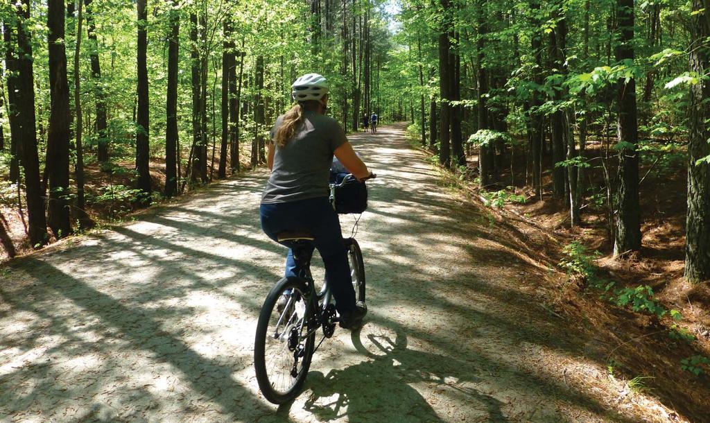
Bicycle/Pedestrian Improve access to transit from each park and provide better awareness of each park at nearby transit stops.
|
|
|
- Erik Stanley
- 5 years ago
- Views:
Transcription


1 . Recommendations
2 Parks and Recreation Master Plan Updates 2016 Overview Wake County is a prime model for livability in North Carolina. Job opportunities, medical centers, education facilities, and inspiring outdoor experiences are among just a small sample of reasons why people choose to live in and visit the area. As growth continues, quality of life for all citizens regardless of age, race, gender, or ability is integral to maintaining healthy, well-balanced communities in rural, suburban, and urban environments. County Parks and Recreation facilities and programs are key contributors to the County s mission to improve economic, social well-being, and physical quality of the community. This plan sets a course for how each facility can be enhanced to respond to the evolving needs of the community and provide quality experiences for generations to come. The recommendations of this plan have been vetted through several perspectives via a robust process of engagement and crosschecking. Each touchpoint of discovering need and determining appropriate action was considered through the lenses of staff, management, citizens, visitors, users, and non-users of all ages and abilities. The purpose of these recommendations is to guide management and staff toward a new vision for each park that complements the context, advances trends in recreation, and focuses on conservation, health and wellness, and social equity. The following pages illustrate improvements at the master planning level, with representative photos, narrative, action steps, funding targets, and conceptual renderings. The division mission and goal is to ensure parks, programs, and resources are accessible all users. Recommendations for the department establish a baseline for each park to provide consistency of information across all communication platforms and a comprehensive wayfinding package to and around each park. Clarity will be critical to encourage new use and provide confidence while navigating each of the parks. Access emerged as the pinnacle to success for the department and each park. This can be defined as access via public transit, access in a sense of approachability, access for users with special needs, and access in the realm of connectivity throughout each programmed space. Together, the overall recommendations and each individual park improvement will result in increased awareness, user experience, environmental health, and social unity for users now and into the next decade. Systemwide Recommendations Throughout the planning process, several recommendations emerged that either were suitable for all parks or were not specific to any one place but would benefit the entire system. These recommendations are outlined below and segmented into the categories of Access + Equity, Facilities, Programs, and Management. Access + Equity emerged as a key topic throughout all input stages, with a strong emphasis on physical, emotional, and social definitions of access from ADA standards to language barriers and public transportation. These recommendations should dovetail with those of the Wake County Greenway System Plan, as well as other countywide transportation and comprehensive planning efforts. Access + Equity Vehicular Improve title signage for visibility and to distinguish from other County facilities. Consider creating a park logo or color palette that distinguishes the parks from other County facilities. Improve welcome sequence. What signage do people see? Where are they directed? How can they access information that will inform a safe and enjoyable visit? Who are they greeted by? Bicycle/Pedestrian Improve access to transit from each park and provide better awareness of each park at nearby transit stops. Connect to Countywide greenway system. Provide sidewalks, crosswalks, countdown signals and/ or HAWK signals at major and (if applicable) minor park entrances. Improve welcome sequence. What signage do people see? Where are they directed? How can they access information that will inform a safe and enjoyable visit? Who are they greeted by? Create a trail rating system to help users understand skill level needed to use a trail. This includes indicating which trails are ADA accessible. Add bicycle parking that meets the requirements of the League of American Bicyclists standards for placement, spacing, and style (replace non-compliant parking). Wayfinding Develop a master wayfinding sign family for the park system. Sign types shall include: title signage (vehicle), title signage (greenway), kiosks (pull up car and pedestrian), directionals (vehicle and bike/ped), loop maps, building/special feature signage, pavement markings, mile markers, and trail blazes. Create an acceptable color pallete and suite of symbols to improve access. Symbols should include a scale for trail difficulty, as well as symbols for park use areas and restrictions. Vehicular signage should indicate where to park, where a welcome center or starting point can be found and major nodes or attractors in the park. Pedestrian and bicycle signs should be placed to capture those arriving via transit and greenway/sidewalk, as well as provide information for those approaching from parking areas. Pedestrian and bicycle signage should, where applicable, indicate distance and time for travel as well as level of difficulty. All trailheads should have kiosks with accurate maps of the trail system, level of difficulty, time investment, and safety information including shade, carrying water, and potential hazards. All loop trails should include mile markers for fitness tracking and safety. Recommendations -2
3 Transit Access, Connections, and Messaging Create awareness for transit to park and park to transit options within maps, brochures, and on the County website. ADA Create primary path that links park features. Coordinate to make sure any programs offered are available for those with physical and mental limitations. Language Provide symbology that is universal in lieu of single language narrative (maps, signs, wayfinding, brochures). User Ability Indicate which facilities are available to persons of various physical and mental skill levels and what the time invested will be per activity. Outreach and Awareness Coordinate website, kiosk, and brochures with same information. Reconcile what is actually offered in each park with outreach materials. Change amphitheater to outdoor classroom on outreach materials, maps, and signage. Create a chart of all activities offered at all facilities and categorize by those offered at each park. Include mileage of trails (multiuse and mountain bike) for user comparison. Facebook and social media are easy and inexpensive avenues for reaching families across the County. Increase the County s presence by having a dedicated Wake County Parks and Recreation Page and consider a page for each park (some parks have a dedicated page). In addition to posting events and activities on the County pages, assign a staff member to monitor other groups, events, and municipal sites for cross posting, promotion, and support. Trail closures should be posted on Facebook, the County website and other social media to provide real-time trip planning. Consider a real-time trail update on the County website (much like how a ski resort indicates when trails are open). Facilities Structures Explore passive solar orientation for all new buildings. Research opportunities to add solar and wind power to all parks. Use LEED guidelines when designing new buildings. Site Furnishings Consider user ability in selecting site furnishings (drinking fountains, signage, seating areas) - ADA accessible, seat level, backs, etc. Include recycling receptacles alongside trash receptacles in each park. Specialty Facilities Consider implementing sustainable landscape programs such as SITES guidelines when making site improvements. Practice low-impact development and consider opportunities to add rain gardens, green roofs, and stormwater collection. Programs Mission and Education Health Cards To coincide with the development of Park Rx Program, Wake County Parks should identify activities that can be accomplished by individuals in 10, 20, 30, 0, and 60 minute increments. These cards should be available in each park display, with information about time and health. The cards should be crafted of sturdy material to enable return and reuse. A marketing campaign should accompany this program and all cards should be visible for trip planning on the County website. In addition to the Health Cards, Wake County should enact a Health and Energy program. This program would have several components. Private partnerships should be explored with Duke Energy to fund personal health tracking devices in parks. These devices could be borrowed (or purchased) at each park to track activity while in the park. These would overcome barriers to health tracking devices for economically challenged individuals. Every person would have the ability to enter a personal number or pin to activate the device and continue to build their personal profile of activity. The County would provide personal login credentials through a health portal on the website where each individual could monitor their steps, calories burned, miles walk/biked/hiked, etc. The park system can become a part of a Countywide media campaign eye on health where the county, in real time, tracks human power, calories burned, etc. as a way to monitor the need to increase physical activity and combat the obesity epidemic, cardiovascular health issues, and inactivity. Provide trip planning messages on brochures and include a trip planner on the website to help people understand how they can get to each park via car, walking, biking, or transit. Management Staff Needs Create a policy for staff to welcome and be accessible to users, especially in concert with improved facilities. Have a resource available in the County to coordinate with staff when developing programs and facilities to represent the needs of special populations (ability, culture, language, etc.). Partnerships Seek a Healthy Routes to Parks partner. Execute a media campaign to link personal and public health to parks via transit and proximity to neighborhoods. Work with the County Health Department to share resources for existing and future initiatives. The County should work with municipal and state parks and recreation departments to connect with doctors and encourage them to begin a Park Rx Program. In this program, doctors will prescribe patients with time spent in parks. Consider local schools as partners. Educate schools about program offerings and facilities available for school classes, programs, and field trips. Develop of list of partners, vendors, and user groups (public, private, non-profit) for each of the parks. Cross promote availability of programs and facilities across the park system for each of these groups. -3 Recommendations

4 Parks and Recreation Master Plan Updates 2016 Park-Specific Recommendations Recommendations -


 at trailheads for improved visibility at dawn and dusk as facilities are opening and closing.")

5 MAIN VISION American Tobacco Trail No current mission statement for this park. The American Tobacco Trail is not just a local trail but a component of an evolving regional system. The trail is a fitness venue for hikers, bikers, and equestrians. It connects urban and rural communities along with corporate and local businesses. Mindful future connections will enhance the natural essence of the trail while expanding educational opportunities about conservation, locomotion, history, and health. Addresses: Wimberly Parking Area: 1017 Wimberly Rd, Apex, NC Unique Feature: Regional Connectivity TRAILHEAD RECOMMENDATIONS ADA ACCESSIBLE PARKING Provide accessible parking spaces and route to the primary trail from existing trailheads. LIGHTING Provide additional lighting (consider Solar/LED fixtures) at trailheads for improved visibility at dawn and dusk as facilities are opening and closing. PARKING SPACES Expand parking areas to accommodate additional car and horse trailer parking. Provide bicycle parking and horse hitches near restrooms and trail entrances New Hill-Olive Chapel Rd Apex, NC Size: 6.5 Miles 1305 White Oak Church Rd Apex, NC Hours: 8 am to 1 hour before sunset BICYCLE REPAIR Provide bicycle repair stations at each trailhead. STRETCHING STATIONS Add stretching stations and outdoor fitness equipment at each trailhead. ART AND INTERPRETATION Add artifacts and art for historic and environmental interpretation along the trail. ACCESS TO FOOD AND WATER Allow mobile food vendors at trailheads and food truck or farmer stands for special events. Provide picnic tables and shelters to facilitate event programming and family picnicking. Provide signage to comfort station and water access and add water bottle, ADA, and pet-friendly water-filling stations. -5 Recommendations


6 ELVIS PERS TION PHASING VE. S. BELLEVUE BLVD. Please Carry Out All Waste P S-78 PAULINE ST. S. CLEVELAND ST. N AVE. 51 THOMAS ST. FIREST Greenway Hours: For Emergency Assistance Call 911 INITY VA R APPLING RD. US-HWY US-HWY. 70 / 79 BROTHER BLV OAK RD. Rules & Regulations Greenway Hours: Dawn till Dusk For Emergency Assistance Call 911 Please Carry Out All Waste Destination Number One Miles 2 Min Destination Number Two Miles 2 Min Destination Number Three Miles 2 Min Destination Number One Destination Number Two Destination Number Three Miles Miles Miles 2 Min 2 Min 2 Min YIELD TO Pass With Care Call Out: On Your Left Parks and Recreation Master Plan Updates HORSE WASTE Explore opportunities to add composting stations at trailheads. BICYCLE AND HORSE RENTAL Research potential mobile vendors to provide bicycles and horses for rent. WAYFINDING Develop a cohesive wayfinding package using the brand of the ATT. Provide kiosks at each trailhead and at key intersections that illustrate the length of the trail, key destinations, trailheads, restrooms, access to water, and the distances and timing via walking and bicycling to arrive at select places along the trail. Coordinate with municipalities for opportunities to co-brand. Use symbols in lieu of language when possible. 2 ART ALONG THE TRAIL identify key locations along the trail (like the Hwy 6 underpass) to include murals, public art, and relics that tell the story of the American Tobacco Trail, history of the area, importance of watersheds, connectivity of the East Coast Greenway, and future of transportation METAL WITH DARK INDUSTRIAL FINISH LETTERING ETCHED AND BURNED INTO CEDAR HUMPHRYES BLVD. HUMPHRYES BLVD. 8x8 POST CARRIAGE BOLT HIGH PRESSURE LAMINATE MAP PANEL HUMPHRYES BLVD Min.2 10 Min.2 10 Min.2 10 Min.2 10 Min.2 10 Min ALUMINUM PANEL INSET IN WOOD MILE 2. HUMPHRYES BLVD. TRAILHEAD 2 1 Kiosk Option 1 Kiosk Option 2 Area Map Directional Front Back Side Side 1 2 Vehicular Trailhead Regulatory Signage SMALL SHELTERS WITH STORAGE AND CABOOSE KIOSK Add shelters with storage areas at each trailhead. Select a key location to add a caboose that will serve as a shelter and information kiosk. TRAILWAY RECOMMENDATIONS TRAIL INTERSECTIONS AND SPURS Provide standards and guidelines to municipalities and neighborhoods to indicate how to properly tie into the trail with signage, trail width, and wayfinding. PULL-OFFS AND RESTING PLACES Explore opportunities to create pull-offs for resting and bicycle repair. Install benches every half to quarter mile. NEW FEATURES 1 GAP CLOSURE AND NOVELTY ATTRACTION Work with New Hope Valley rail line to provide a stop at the east end of their passenger line that could close a critical gap in the ATT and become a major bike to train destination. 3 FUTURE CONNECTIONS As connections to points east are completed, indicate on wayfinding signage the time and distance to the Neuse River Greenway, Downtown Cary, Downtown Apex, and Downtown Raleigh. FUTURE CONNECTIONS Extend greenway from passenger rail line to Harris Lake County Park. BOLLARDS AND FENCES Ensure fence and bollard spacing allows for wheelchair, stroller, and bike carriage accessibility. Recommendations -6

7 American Tobacco Trail -7 Recommendations

8 Parks and Recreation Master Plan Updates American Tobacco Trail recommendations Recommendations -8


9 Blue Jay Point County Park Address: 3200 Pleasant Union Church Road, Raleigh NC, 2761 County s population to experience environmental education in a natural setting. Unique Features: Adventure Recreation/Retreat Center Size: 236 Acres Hours: 8 am-sunset Exhibit Center 8 am-5 pm MAIN VISION Blue Jay Point offers its visitors the best of outdoor recreation and environmental education opportunities. Groups and individuals alike can spend an entire day learning, playing and exploring amongst the park s Center for Environmental Education, trails, shoreline, educational garden and open play fields. Whether you re looking for a quiet, meditative space, a beautiful shoreline to explore, or even a treetop challenge for the more adventurous types, Blue Jay has something to offer every outdoor enthusiast. NEW FEATURES CAMPING Provision of an area for on-site camping was supported by the public during the planning process. Further exploration is recommended to determine where to site the camping, which type of camping will be permitted, and how this addition will affect rules, regulations, and staffing ACCESSIBLE KAYAK LAUNCH Provide kayak launch for users of all abilities. OVERLOOK Provide opportunities along the trail to view the natural habitat. CHALLENGE HIKING Use the existing steep topography to create hiking trails for more advanced users. Provide additional signage where these trails cross the MST. 5 ADA LOOP TRAIL Provide opportunities to interact with the habitat to visitors of all abilities. SMALL SHELTER New shelters should be integrated into the natural surroundings and may take on a more current style. -9 Recommendations
 and/or covered gathering space for day camps and classes.")


10 Parks and Recreation Master Plan Updates 6 Provide a shelter with restrooms, fireplace, and storage that can serve as a gathering space for large groups (200+) and/or covered gathering space for day camps and classes. 8 9 BLUEWAY Add markers and stopping points along a blueway trail that skirts the shoreline of the park. PARKING This lot will accommodate shelter users and visitors using the kayak launch. ENHANCED FEATURES 10 EDUCATION CENTER Expand to provide additional education and display space. 11 NATURE PLAY Expand and enhance the current nature play area. 7 KAYAK BEACH AND OVERLOOK Provide an accessible route from the park center near the active play area to an overlook and kayak access location. In this same location, create an entrance to the park from the water and blueway trail. 12 EXISTING RETREAT CENTER Expand opportunity for a variety of organizations to make use of the center. Blue Jay Point County Park Recommendations -10


11 Blue Jay Point County Park -11 Recommendations

12 Parks and Recreation Master Plan Updates Blue Jay Point County Park recommendations Two foot contours FEET Recommendations -12


13 Crowder District Park Address: 709 Ten Ten Road Apex NC, Unique Features: Gardens/Environmental Programs Size: 33 Acres Hours: 8 am-sunset, 7 days a week MAIN VISION Crowder District Park provides a sense of community in a suburban area. The park is a destination for daily health and physical activities and serves as a place for family/group gatherings and education programming. Utilizing the natural and built elements, themed gardens and plantings, the park hopes to improve the connection between visitors and the environment. Connectivity to existing/future greenways and parks and the acquisition of surrounding property will allow Crowder District Park to expand its programs, facilities, services, and overall community presence. NEW FEATURES 1 2 BOG GARDEN Create a garden with opportunities for play and water quality education. NATURE PLAY A new nature play area will support daily use and can be designed to support park programming. 3 HEALING GARDEN Provide a quiet respite for self-reflection, yoga, stretching, and connecting with self and nature. BACK PORCH Add classroom space in the form of a large screenedin back porch similar to the classroom space at Prairie Ridge. -13 Recommendations


14 Parks and Recreation Master Plan Updates 5 BOARDWALK Add boardwalk to link new back porch with existing boardwalk. Include kayak and water education access for staff during programs and creative platforms for water interaction. 7 DOG AMENITIES Add dog water fountains and additional waste stations along the trail to serve the large population of dogs in the park PARK ENTRANCE Explore realigning the entrance with Cortland Dr. during Ten-Ten Road Improvement Project. PARK CENTER Improve maintenance area, expand welcome center, add parking, and create a welcome plaza, focused on pedestrian arrivals and large enough for gatherings or check-in tents for special events. 11 BIRD GARDEN Provide opportunities for learning more about the connection between plants and birds and add a nest outdoor classroom. 6 HEALTH & WELLNESS GARDEN Replace existing playground equipment and add multigenerational exercise equipment at this location and along the primary greenway trail. ENHANCED FEATURES 8 CONNECTIVITY AND VISIBILITY Support installation of a sidewalk along Ten-Ten Road for pedestrian access and the exploration of a Complete Streets study to provide equity in transportation. Clear vegetation to improve visibility of existing entrance sign. Add a park sign at each property corner to indicate park entrance ahead. Work with NCDOT on adding sidewalks and fully controlled pedestrian crosswalks at Ten-Ten Road and Holly Springs Road to connect nearby neighborhoods and improve pedestrian access to the park. Recommendations -1

15 Crowder District Park 12 PRAIRIE GARDEN Expand the garden by adding vegetation, interpretive signs, and seating areas. 13 GREENWAY CONNECTIVITY Expand the trail system in the park to connect to regional greenway systems RAIN GARDEN Enhance the garden by adding interpretive signage and improving the conveyance and storage functions. BUTTERFLY GARDEN Expand the garden and add interpretive signage. -15 Recommendations

16 Parks and Recreation Master Plan Updates Crowder District Park recommendations Two foot contours FEET Recommendations -16


17 Harris Lake County Park No current mission statement for this park. Address: 2112 County Park Drive, New Hill NC, Unique Features: Hiking Size: 680 Acres Hours: 8 am-sunset, 7 days a week MAIN VISION Harris Lake is the Destination for the Day, a place to reconnect with nature through recreational and educational opportunities. There is something here for each family member to enjoy be it fitness and health-related activities or just back to the simple things in life like fishing and family picnicking. It is nature that connects play, education, and overall human development together. NEW FEATURES CAMPING Provision of an area for on-site camping was supported by the public during the planning process. Further exploration is recommended to determine where to site the camping, which type of camping will be permitted, and how this addition will affect rules, regulations, and staffing. NAME EACH POND Mark each pond with a naming sign and add names of the ponds to the trail maps to aid in navigation. 1 2 LOOP ROAD AND GREENWAY Use the service road to expand vehicular circulation toward the point and bring users to additional places within the park. Create a minimum 10 foot wide ADA greenway loop to enhance access and serve users who prefer this surface type to soft surface trails. GREENWAY CONNECTIVITY Expand the trail system in the park to connect to regional greenway systems. TREE TOP TRAIL Create an elevated trail in the tree canopy that is ADA accessible with several overlooks, hammocks, and spaces that can serve as an outdoor classroom. 3 PARKING AND COMFORT STATION To accommodate disc golf and tree top trail users. -17 Recommendations


18 Parks and Recreation Master Plan Updates 5 PARK CENTER Design a new solar-powered, energy efficient park center to become the official arrival point for visitors. Include offices, indoor classrooms, display areas, restrooms, and storage. Add sufficient parking to accommodate events and groups using the new center. ENHANCED FEATURES 7 8 HIKING TRAILS Add wayfinding, mile markers, and interpretive signage to help navigate and celebrate the mission of the park. TRAIL SYSTEM Add connector trails to shorten loops and enhance access for users. 12 PLAYGROUNDS AND WATER ACCESS Expand the natural play area and upgrade the existing playground. Enhance water access by creating a kayak/ paddleboard/canoe launch with ADA accessibility. Explore the potential of adding a vendor to rent human powered watercraft DISC GOLF Create courses that are ADA accessible and youth friendly. MAINTENANCE AREA Expand the maintenance area to better suit the needs of the grounds, programming, and staff. MOUNTAIN BIKING NETWORK Create sustainable trails and improve rider experience to accommodate a wider variety of skill levels. Enhance the existing trails with signage. 6 BLUEWAY Create a blueway trail along the shoreline using floating mile markers and interpretive signage. Harris Lake County Park Recommendations -18


19 Harris Lake County Park -19 Recommendations

20 2 Parks and Recreation Master Plan Updates Harris Lake County Park recommendations Two foot contours FEET Recommendations -20


21 Historic Oak View County Park In the tradition of a great state which celebrates its past, cherishes its heritage, and nurtures its resources for future generations, Historic Oak View County Park interprets and preserves the agricultural heritage and rural farm life of North Carolina through educational programs, special events, and exhibits, and provides cultural enrichment and passive recreation opportunities for visitors. Address: 028 Carya Drive, Raleigh NC, Unique Features: Historic Farm Size: 27 Acres Hours: 8 am-sunset, 7 days a week NEW FEATURES FARM TO TABLE Look for opportunities that teach about farm-to-table methods using local farmers and food grown at Oak View. 2 ACCESSIBLE GARDEN Allow all users to experience the garden plots by widening the walking aisles and raising the garden beds to easier access. MAIN VISION 1 PEDESTRIAN PATHWAYS Create a primary loop trail around the park and additional ADA accessible pathways to connect each park feature. Historic Oak View County Park interprets North Carolina s diverse agrarian past and invites families to explore and connect with daily farm life. Expanding the park s educational and recreational opportunities will enhance the visitor experience and broaden its role in the community. 3 PARK EXPANSION AREA Offer additional park features including a playground, walking and hiking paths, and fishing platform. -21 Recommendations


22 Parks and Recreation Master Plan Updates INTERPRETIVE PLAY Create and enhance interpretive play spaces throughout the park that allow for interactive learning and user activities that simulate life on the farm. 8 MAIN FARMHOUSE Complete updates and enhancements of permanent exhibits. 13 FISHING ACCESS Improve access near the existing ponds for viewing and fishing while maintaining the natural farm feel of the edge of the lake. 5 6 FISHING PLATFORM Provide access to pond. PLAYGROUND Create new farm-themed playground. ENHANCED FEATURES 7 SIDEWALK AND TRANSIT CONNECTIVITY Expand the trail system in the park to connect to proposed sidewalk facilities, public transit systems, and other recreational amenities, such as the Neuse River Trail FORMAL ENTRY Provide designated entry into historic building. CROPS Expand opportunities to cultivate food on the farm and use for educational purposes. CONNECTIVITY Expand the trail system in the park to connect to Wake County office park and facilities and nearby Neuse River Trail. PARKING AREA Add additional parking spaces REAL ANIMALS Add more live animals to the farm to allow for enhanced interaction with farm life, an opportunity to learn about historic and present day practices, improved user experience, and expansion of the attractions on the farm. SOUND WALL Sound wall on west side of property between I-0 and main farm buildings. Historic Oak View County Park Recommendations -22


23 Historic Oak View County Park -23 Recommendations

24 Parks and Recreation Master Plan Updates Historic Oak View County Park recommendations Two foot contours FEET Recommendations -2


25 Historic Yates Mill County Park Escape the Daily Grind through a variety of unique recreational, cultural, natural and agricultural experiences. Address: 620 Lake Wheeler Road, Raleigh NC, Unique Features: Historic Mill Size: 17 Acres Hours: 8 am-sunset, 7 days a week MAIN VISION Historic Yates Mill County Park celebrates its past, cherishes its heritage, and nurtures its cultural and natural resources for future generations. NC State University s agriculture research farm provides the backdrop and offers glimpses into North Carolina agricultural heritage while protecting significant wildlife habitat in the heart of Raleigh. Expanded trails will elevate the park as a favorite day-use facility for health and wellness while new historical elements will provide users with a reason to linger longer. The relationship between Wake County, Yates Mill Associates, and NC State University, the physical connection with modern agricultural practices, and university based research in natural resource management, will draw groups and individuals looking for an experience in local North Carolina history, an escape into our natural world and quality environmental education. NEW FEATURES BOARDWALK Add a boardwalk through the wetlands to create a loop for trail users. CLASSROOM AND PICNIC AREA Provide new covered shelter to serve as outdoor classroom. ART IN THE FIELD Add art and artifacts that attract visitors and highlight the park entrance. Incorporate art and artifacts near the classroom space that tell the story of the park and create a flexible play space. 5 6 VILLAGE AND HISTORIC ACTIVITIES Add village buildings to create historic activity spaces for a blacksmith and a house creamery, as well as appropriate buildings for a gift shop and concessions. ADA TRAIL TO MILL Add accessible trail to allow people of all abilities to visit the mill. WATERFRONT ACCESS AREA Provide access and water interaction opportunities that encourage picnicking and water activities, such as canoeing and kayaking. -25 Recommendations
26 Parks and Recreation Master Plan Updates 7 OVERLOOK Provide areas along trail to view mill and pond habitat. ENHANCED FEATURES 8 GREENWAY CONNECTIVITY Expand the trail system in the park to connect to regional greenway systems MILL EXPERIENCE Create an ADA accessible entrance to the Mill that protects the integrity of the historic structure. Expand the historic experience by relocating the Phares Yates House to this property and providing access and interpretive signage. PARKING Explore opportunity to share parking with the recycling center for event overflow parking. 9 MAINTENANCE AREA Move some maintenance functions away from the waterfront and expand maintenance area. Screen views into maintenance area with vegetative border. 10 OVERFLOW PARKING AND FLEX-SPACE ENTRANCE Provide new entry signage and clear vegetation to improve visibility and create a more legible park entrance. 11 GREENWAY AND TRANSIT CONNECTIVITY Create key connections to NCSU facilities, nearby sidewalk/paths, and the State Farmers Market. These connections not only create physical opportunities to increase visitation and cross promotion but also tell the agricultural story and mission of the park. Ensure that a road crossing to the NC State greenway is safe by using crosswalks and other devices such as HAWK signals to alert drivers of pedestrian crossings. Collaborate with NC State to explore the potential of connecting people to this park via the Wolfline. Coordinate with NCDOT to explore a greenway connection as part of the bridge replacement project at Lake Wheeler Road. Historic Yates Mill County Park Recommendations -26


27 Historic Yates Mill County Park -27 Recommendations

28 Parks and Recreation Master Plan Updates Historic Yates Mill County Park recommendations Two foot contours FEET Recommendations -28


29 Lake Crabtree County Park Address: 100 Aviation Parkway, Morrisville NC, recreational opportunities available in a natural setting. Unique Features: Mountain Biking/Water Access Size: 215 Acres Hours: 8 am-sunset, 7 days a week Park office, 8 am-1 pm MAIN VISION This park is truly everyone s park. From the ADA accessible trails to the new accessible kayak launches, and connections with trails and transit equity in recreation, leisure, and wellness is the focus. Multi-generational spaces create opportunities for the whole family to enjoy an hour or a whole day at the park. Water activities, peaceful trails, picnic shelters, and multiuse trails provide opportunities for enjoyment for daily activities and special events for all ages and abilities. ACCESSIBILITY FEATURES ADA ACCESSIBLE PARKING Provide accessible parking spaces to all use areas and the primary loop trail. ADA ACCESSIBLE TRAIL LOOP Enhance the existing loop trail to provide equality in mobility and access for all park users. PARK CONNECTIVITY ACCESSIBILITY Renovate park trails and sidewalks to create ADA accessible paths connecting each use area in the park. NEW FEATURES BOARDWALK Constructed in conjunction with future roadway improvements. TRAIL EXPANSION AREA Expand trails across Aviation Parkway. CONNECTIVITY Improve connectivity with crosswalks, links to existing greenways, sidewalk connections to RDU, and coordination with area transit for stop locations and wayfinding. Extend trails across Aviation Parkway to increase total trail length. 5 6 SIDEWALK Complete the pedestrian connection from the entrance and tie into the new park loop. TRAILHEAD Provide a trailhead near the mountain biking trails that has a shelter, bike fix it station, restrooms, first aid station, and changing area. PARK CENTER Create a new Park Center with an iconic building that provides an educational setting, a place for rest and relaxation, observation of the waterfront, and park support facilities. The iconic tower will be re-imagined to preserve the overlook while enhancing safety and accessibility. -29 Recommendations


30 Parks and Recreation Master Plan Updates 7 BLUEWAY Add mile markers and resting places along a blueway trail that skirts the shoreline. 11 GATHERING SPACE Provide a new picnic shelter and restrooms for large groups (over 100 people), new playground, and multi-generational park activities suitable for varied ages and abilities. ENHANCED FEATURES 8 GREENWAY CONNECTIVITY Collaborate with municipalities and the office parks to complete a loop around the lake. 9 PARKING Expand existing parking areas. 10 LOOP TRAIL Enhance the existing loop trail to become an ADA accessible Lake Loop. The route would improve connectivity throughout the park and provide new connections to the Cary and Morrisville greenway systems. Lake Crabtree County Park Recommendations -30


31 Lake Crabtree County Park -31 Recommendations

32 Parks and Recreation Master Plan Updates Lake Crabtree County Park recommendations Two foot contours FEET Recommendations -32


33 North Wake Landfill County Park No current mission statement for this park. Address: 9300 Deponie Drive Raleigh NC, 2761 Unique Features: Reuse/Viewshed Size: N/A Hours: 8 am-sunset, 7 days a week NEW FEATURES CHANGE THE NAME Create a committee or hold a contest to create a new name better aligned with the main vision. ART ON THE HILL Provide a setting for student/community developed art to be placed on the mound. At the east, visitors will view the art from the trail and surrounding area. MAIN VISION 1 TRANSIT CONNECTION Work with CAT to create a stop near the park entrance. This park brings waste, conservation, recycling, and reuse to the forefront of visitor experience. Opportunities will be created throughout the park to reflect on the importance of conscious use of materials, human effects on the earth, and how re-thinking materials which some consider trash can become beautiful art and vehicles for creativity and recreation. 2 3 PARKING To serve top of the hill trail. DUMPSTER PLANTERS Up-cycle dumpsters as planters to provide shade without penetrating the mound. Enlist artists to design each dumpster to tell a story of energy, consumption, and human impacts on the earth. 5 6 PARKING To serve mountain biking trails. INTERPRETIVE VEGETATION Plant bands of native vegetation in colored patterns around the hill to illustrate the height the landfill grew over a period of time. Pair the plantings with interpretive signage around the park. -33 Recommendations


34 Parks and Recreation Master Plan Updates 7 ART LOOP TRAIL + STORY FENCE Create a loop trail around the northern mound to link with Abbotts Creek Trail. To prevent access to the mound, install a story fence to educate visitors about waste, recycling, and re-use. 12 SKATE TRAIL Create a trail system with below-ground level and aboveground ramps. Plazas, railings, and jumps will be created specifically for tricks and challenges for multiple levels. The loop trail will continue on the outside of the skate trail to provide connectivity and observation. ENHANCED FEATURES 15 MOUNTAIN BIKE TRAILS Expand the trail network as planned in the previous master plan. 16 TOP OF THE HILL To provide shade while preserving views. 17 PLAYGROUND To provide shade for youth and adults. 8 RECYCLE PLAY A different take on nature play using recycled materials instead of natural elements to coincide with the theme of the park. 9 TRAIL To connect with Abbotts Creek Trail. 13 TRAIL To connect with the school and community center. 10 LOOP TRAIL Create a greenway trail that loops the perimeter of the road and connects uses throughout the park with dog support facilities including fountains and waste stations. 1 ADA ACCESSIBLE TRAIL A new trail leading to the top of the main hill will be manageable for those with limited physical abilities with gradual slopes, landings, benches, and shade. 11 PARKING This lot will accommodate visitors to the skate trails and art loop. North Wake Landfill County Park Recommendations -3


35 North Wake Landfill County Park -35 Recommendations

36 1 Parks and Recreation Master Plan Updates North Wake Landfill County Park recommendations Two foot contours FEET Recommendations -36
Lake Myra County Park. Wake County, North Carolina Community Forum #2 June 12, 2008
 Lake Myra County Park Wake County, North Carolina Community Forum #2 June 12, 2008 Welcome and Introduction Meeting Agenda Welcome Introductions of Project Team Master Plan Process Community Forum #1 Updates
Regional Wayfinding Sign Strategy Thurston County Trails 2017
 Regional Wayfinding Sign Strategy Thurston County Trails 2017 Partners: Members and partnering organizations of the Thurston Thrives Community Design Action Team City of Lacey, City of Olympia, City of
Wilds. Headwaters. Lakes. Oxbows. Falls
 56 5 4 3 Wilds Headwaters Lakes Oxbows Falls 57 Zones It could be said the on-the-ground essence of this master plan appears within the next 6 pages of this report. As we learned in the preceding Cultural
Welcome to the future of Terwillegar Park a Unique Natural Park
 Welcome to the future of Terwillegar Park a Unique Natural Park 1 Introduction The Terwillegar Park Concept Plan study will develop an overall concept plan, management objectives and development guidelines
The Vision for the San Juan Islands Scenic Byway
 The Vision for the San Juan Islands Scenic Byway 2 Judd Cove, Orcas Island, Courtesy of Kurt Thorson (kurtthorson.com) and San Juan County Land Bank Vision for the San Juan Islands Scenic Byway The San
Chapter 2: Summary of Existing Open Space System
 Chapter 2: Summary of Existing Open Space System In 1976, the Wake County Board of Commissioners established the Wake County Parks and Recreation Department in order to provide park facilities and programs
Silver Lake Park An Environmental Jewel for the Citizens of Prince William County
 Silver Lake Park An Environmental Jewel for the Citizens of Prince William County The Prince William Park Authority Mission Statement states: The Prince William County Park Authority will create quality
Port Gamble Shoreline Area Conceptual Trail Proposal
 The North Kitsap Trails Association is pleased to be a partner to the Kitsap Forest and Bay Project and assist Kitsap County, Forterra, Olympic Property Group, Great Peninsula Conservancy and the Port
Blueways: Rivers, lakes, or streams with public access for recreation that includes fishing, nature observation, and opportunities for boating.
 Parks, Open Space and Trails PRINCE WILLIAM COUNTY 2008 COMPREHENSIVE PLAN TRAILS PLAN CONTENTS The components of the trails plan are: Intent Definitions Goals, Policies, and Action Strategies Trails Map
City of Durango 5.8 FUNDING TRAILS DEVELOPMENT
 5.8 FUNDING TRAILS DEVELOPMENT The City has been successful in establishing dedicated local funding sources as well as applying for grants to develop the City s trail system, having received nearly $2.4
ADVENTURE PLAN EXPLORE PARK
 ADVENTURE PLAN ROANOKE COUNTY S EXPLORE PARK ROANOKE COUNTY PARKS, RECREATION AND TOURISM 1206 KESSLER MILL RD SALEM, VA 24153 (540) 387-6078 WHAT S INCLUDED? Explore Park Adventure Plan - Guided by extensive
Appendix 3. Greenway Design Standards. The Whitemarsh Township Greenway Plan
 Appendix 3 Greenway Design Standards This chapter discusses two design standards for the greenway types discussed above. First, trail design standards are presented together with trailhead facilities and
NORTHWEST SECTION CONTENTS: CLEVELAND PARK FOLWELL PARK RYAN LAKE PARK VICTORY PRAIRIE DOG PARK VICTORY PARK
 NORTHWEST SECTION CONTENTS: CLEVELAND PARK FOLWELL PARK RYAN LAKE PARK VICTORY PRAIRIE DOG PARK VICTORY PARK LUCY LANEY COMMUNITY SCHOOL N 33RD AVE N 33RD AVE SINGLE-FAMILY RESIDENTIAL MULTI-USE DIAMOND
Assessing Your Trails, Keeping Them Safe and Enjoyable
 Jon Wood, PLA, ASLA Associate Vice President Stewart Bert Lynn, PLA, ASLA, LEED AP Project Manager Mecklenburg County Asset and Facility Management Assessing Your Trails, Keeping Them Safe and Enjoyable
Chapter 6: POLICY AND PROCEDURE RECOMMENDATIONS
 Chapter 6 POLICY AND PROCEDURE RECOMMENDATIONS FOR SRRA Below are seven policy elements that should be considered for adoption by the Southwest Regional Recreation Authority of Virginia: 1. Develop strategies
WATER PETALUMA TRAIL WATER WAYS PROJECT PORTFOLIO. petalumawaterways.org OVERVIEW
 WATER TRAIL PROJECT PORTFOLIO OVERVIEW Thirteen miles upstream of San Pablo Bay, Petaluma is the northern point on the San Francisco Bay Water Trail, a network of access points throughout the region. Most
Understanding the caring capacity of the visitor experience Provide facilities to support a high level user experience Address visual quality through
 Understanding the caring capacity of the visitor experience Provide facilities to support a high level user experience Address visual quality through recreation ecological restoration opportunities Collaboration
Citrus Heights Creek Corridor Trail Project Trail Advisory Group Field Trip #2 September 11, :00 11:00 am Trellis Hall, Citrus Heights
 September 11, 2013 9:00 11:00 am Trellis Hall, Citrus Heights Project Overview The City of Citrus Heights is studying the feasibility of establishing a multi use trail system within the City s 26 miles
Proposal to Redevelop Lower Kananaskis River-Barrier Lake. Bow Valley Provincial Park
 Frequently Asked Questions Proposal to Redevelop Lower Kananaskis River-Barrier Lake Bow Valley Provincial Park Frequently Asked Questions What has been decided? What are the details of the plan? What
Chapter eight. Parks and Recreation. Introduction. Crystal Lake Park District
 Chapter eight Parks and Recreation Introduction One of the indicators of quality of life in a city is the parks and recreation system. The City of Crystal Lake is fortunate to have an excellent parks and
Lafourche Parish Government REQUEST FOR QUALIFICATIONS. Landscape Architectural Services
 Lafourche Parish Government REQUEST FOR QUALIFICATIONS Landscape Architectural Services Bayou Lafourche Parish Multi-Use Path Feasibility Study Phase 1 And Bayou Lafourche Parish Multi-Use Path Feasibility
A Vision for South Skunk River and Chichaqua Bottoms Greenbelt
 A Vision for South Skunk River and Chichaqua Bottoms Greenbelt Photo: Jim Pease Chichaqua Bottoms Booklet 7 of 8 Greater Des Moines Water Trails and Greenways 1 2016 Table of Contents Booklet 1: Water
Hudson Highlands Fjord Trail Draft Master Plan. April 29, 2015
 Hudson Highlands Fjord Trail Draft Master Plan April 29, 2015 Agenda Route Overview Proposed Segment Results of Community Survey on that Segment Next Steps Municipal Endorsement Environmental Review Implementation
Waukee Trailhead Public Art and Amenities Project
 Waukee - Trailhead Public Art and Amenities Project Sponsor Waukee Project Title Waukee Trailhead Public Art and Amenities Project Termini Description ( i.e. Park Avenue to 19th Street) NE Intersection
TOURISM & PUBLIC SERVICES RURAL SIGNAGE POLICY
 Policy and Procedures Subject Title: Tourism and Public Services Rural Signage Policy Corporate Policy (Approved by Council): X Policy Ref. No.: ROADS-01-07 Administrative Policy (Approved by CAO): By-Law
CHAPTER 5. Chapter 5 Recreation Element
 CHAPTER 5 Recreation Element Chapter 5 Recreation Element The Recreation Element of the Meyers Area Plan is a supplement to the Recreation Element of the TRPA Regional Plan and the El Dorado County General
Committee. Presentation Outline
 CW-33-15 11/9/2015 Community and Corporate Services Committee November 10, 2015 1 Presentation Outline Background Vision and Objectives Study Process and Timeline Public and Stakeholder Engagement Organization
City of Haslett. City of East Lansing. City of East Lansing
 Central Park North (Nancy L. Moore Park) Lake Park North Expansion White Park Expansion #2 White Park Expansion #1 County East East Haslett East East TF87-212 Acquisition $90,000.00 Park. TF08-138 Acquisition
MASTER PLAN EXECUTIVE SUMMARY
 Biscuit Run State Park Scottsville Road (State Route 20) Charlottesville, VA 22902 Biscuit Run State Park MASTER PLAN EXECUTIVE SUMMARY Department of Conservation and Recreation Division of Planning and
Auburn Trail / Ontario Pathways Trail Connector Feasibility Study Public Information Meeting Wednesday, August 22, 2012
 Auburn Trail / Ontario Pathways Trail Connector Feasibility Study Public Information Meeting Wednesday, August 22, 2012 Purpose of Feasibility Study Purpose Evaluate the feasibility of constructing a multiuse
EXECUTIVE SUMMARY PROGRAM DEVELOPMENT REPORT PURPOSE EXISTING SETTING EXPANDING PARKLAND
 EXECUTIVE SUMMARY PROGRAM DEVELOPMENT REPORT PURPOSE As the culmination of the first phase of the master planning process, this Program Development Report creates the framework to develop the Calero County
West Orange Trail. Clean, Green, Fun!
 West Orange Trail Clean, Green, Fun! The West Orange Trail - when completed - will be a 36-mile, multipurpose recreational greenway containing a 14-foot wide paved surface to be enjoyed by walkers, joggers,
Parks and Recreation Master Plan
 Emerging Themes Parks and Recreation Master Plan City of Mount Dora, Florida September 17, 2018- Revised October 1, 2018 Agenda Welcome & duction Master Plan The Inventory & Existing Community Overview
Longmont to Boulder Regional Trail Jay Road Connection DRAFT FINAL REPORT
 Longmont to Boulder Regional Trail Jay Road Connection DRAFT FINAL REPORT December 2018 Project Summary Boulder County, Colorado, in partnership with the City of Boulder, is evaluating options for multi-use
Pier Enhancements April 6, 2017
 Pier Enhancements April 6, 2017 Pier Enhancement Categories Pier Plaza Improvements Contingency Play Elements Destination Differentiators Water Recreation Zone Furniture, Fixtures & Equipment Transportation
TRUCKEE TAHOE AIRPORT DISTRICT BOARD OF DIRECTOR STAFF REPORT
 AGENDA ITEM: 11 TRUCKEE TAHOE AIRPORT DISTRICT BOARD OF DIRECTOR STAFF REPORT AGENDA TITLE: MEETING DATE: January 24, 2018 PREPARED BY: NTPUD Agency Partnership Opportunity, Multi-Use Trailhead Access
Proposal to Redevelop Lower Kananaskis River-Barrier Lake. Bow Valley Provincial Park. Frequently Asked Questions
 Proposal to Redevelop Lower Kananaskis River-Barrier Lake Bow Valley Provincial Park Frequently Asked Questions What is being proposed? What are the details of the proposal? Where is the project area located?
TORONTO TRANSIT COMMISSION REPORT NO.
 Form Revised: February 2005 TORONTO TRANSIT COMMISSION REPORT NO. MEETING DATE: SUBJECT: Resubmitted December 19, 2012 November 21, 2012 MODERNIZING THE TTC A NEW APPROACH TO COMMUNICATIONS, COMMUNITY
NEWBORO AND PORTLAND HARBOUR REDVELOPMENT PLANS
 INTRODUCTION The Municipal docks in both Newboro and Portland were transferred to the Township of Rideau Lakes by Parks Canada in 2002. Little has been done to improve the docks physical condition or role
Logo Department Name Agency Organization Organization Address Information 5700 North Sabino Canyon Road
 Logo Department Name Agency Organization Organization Address Information United States Forest Coronado National Forest 5700 North Sabino Canyon Road Department of Service Santa Catalina Ranger District
Villages at Buffalo Run East
 Villages at Buffalo Run East Neighborhood Park Subhead to title page goes here. Public Design Meeting April 9, 2015 Capital Improvement Program Commerce City s $137 million CIP is the result of a 2013
The Baker/Carver Regional Trail is intended to
 Section V Design Guidance The Baker/Carver Regional Trail is intended to safely accommodate 183,000 annual visits, an array of non-motorized uses, a variety of skill levels, and persons with special needs.
TRAILS INTERSECTION SIGNS
 TRAILS INTERSECTION SIGNS Intersection signs shall be placed at all trail intersections and located a minimum of 3 from the edge of trail. The top of the post shall pitch away from the sign and trail.
Preferred Recreation Recommendations Stemilt-Squilchuck Recreation Plan March 2018
 Preferred Recreation Recommendations Stemilt-Squilchuck Recreation Plan March 2018 Below are the recommended recreation ideas and strategies that package together the various recreation concepts compiled
River Parks Trail: Tulsa, Oklahoma
 River Parks Trail: Tulsa, Oklahoma Purpose: The purpose of the River Parks Trail is to maintain, preserve, develop, and promote the Arkansas River for the economic and cultural benefit of the community.
FEASIBILITY CRITERIA
 This chapter describes the methodology and criteria used to evaluate the feasibility of developing trails throughout the study areas. Land availability, habitat sensitivity, roadway crossings and on-street
PIONEER PARK. City of Des Peres Parks Master Plan. SWT Design 46 INTRODUCTION
 PIONEER PARK INTRODUCTION Pioneer Park is a 7 acre neighborhood park located east of Interstate 270 and south of Manchester Road along Tallie Road. The park is situated in a residential neighborhood with
Acquisition in fee simple of approximately one-half acre of property on the shore of Spring Lake to expand the Lakeside Beach Park.
 Lakeside Beach TF00-136 $122,550.00 in fee simple of approximately one-half acre of property on the shore of Spring Lake to exp the Lakeside Beach. 2000 River Ravines TF00-150 $910,000.00 in fee simple
2. Goals and Policies. The following are the adopted Parks and Trails Goals for Stillwater Township:
 D. PARKS AND TRAILS 1. Introduction Stillwater Township s population is relatively low, with most residents living on rural residences on large lots. The need for active park space has been minimal in
2009 RIVER TOWN OF THE YEAR AWARD APPLICATION Supplemental Material Images
 2009 RIVER TOWN OF THE YEAR AWARD APPLICATION Supplemental Material Images Our History The earliest record of settlement along the river is in 1854; one of the earliest in Carroll County. About this time
METRO FLEET FUNDING HUMAN RESOURCES
 2018 FACT SHEET METRO FLEET METRO s overall revenue-producing fleet totals 235 vehicles: 144 large buses and 91 smaller paratransit buses. Some passenger vehicles are equipped with a hydraulic lift to
M E S T I Z O C U R T I S P A R K
 ARAPAHOE CONNECTION TO BUS ROUTE AT ND AND LAWRENCE, FUTURE LIGHT RAIL STATION LEGEND SOCIAL TRAIL FLAGSTONE PAVING TO RESTORE/MAINTAIN CONCRETE PAVING DIAGONAL CURVILINEAR SOCIAL ROUTE IS OUT OF HISTORIC
GLASS HOUSE MOUNTAINS PEAKS WALK, BEERBURRUM TRAILHEAD DRAFT CONCEPT PLAN
 GLASS HOUSE MOUNTAINS PEAKS WALK, BEERBURRUM TRAILHEAD DRAFT CONCEPT PLAN GLASS HOUSE Figure 1 REGIONAL WALK/RIDE OVERVIEW Aspirational Goal Create an interconnected nature-based recreation trail network
PARKS & BEACHES PROJECTS
 #18 72ND STREET PARK, LIBRARY, #19 BLUEWAYS & AQUATIC CENTER $1.1 MILLION $60 MILLION New facility to include: Create Kayak Launches with All Wheels Skate Park Floating Docks and Seating at: Library/Media
AGENDA ITEM 5 D WAKULLA ENVIRONMENTAL INSTITUTE (WEI) TRAIL FEASIBILITY STUDY
 TRAIL FEASIBILITY STUDY") March 19, 2018 AGENDA ITEM 5 D WAKULLA ENVIRONMENTAL INSTITUTE (WEI) TRAIL FEASIBILITY STUDY TYPE OF ITEM: Action STATEMENT OF ISSUE The Wakulla Environmental Institute (WEI) Trail is one of several trails
March 19, 2018 AGENDA ITEM 5 D WAKULLA ENVIRONMENTAL INSTITUTE (WEI) TRAIL FEASIBILITY STUDY TYPE OF ITEM: Action STATEMENT OF ISSUE The Wakulla Environmental Institute (WEI) Trail is one of several trails
State Park Visitor Survey
 State Park Visitor Survey Methods, Findings and Conclusions State s Department of Recreation, Park and Tourism Management surveyed state park visitor and trip characteristics, and collected evaluations
A CASE FOR COMPLETING THE JORDAN RIVER PARKWAY: A
 A CASE FOR COMPLETING THE JORDAN RIVER PARKWAY: A safe crossing at 9000 South and 850 West Proposed 9000 South Underpass Parkway Timeline Parkway, Trail, and Tourism Facts Blueprint Jordan River 1971 1973
FIRE Equipment Fire Training Equipment 105, , Total of Equipment 105, ,
 FIRE Equipment Fire Training Equipment 105,000-105,000 - - - - - - - - - - Total of Equipment 105,000-105,000 - - - - - - - - - - Fire Apparatus Aerial Ladder Replacement 5,320,000 1,120,000 - - 1,400,000
DESCRIPTION OF DRAFT LAND USE PLAN ALTERNATIVES. Overview of Draft Alternatives (Common Features and Themes)
") Concord Hills Regional Park Land Use Plan EAST BAY REGIONAL PARK DISTRICT DESCRIPTION OF DRAFT LAND USE PLAN ALTERNATIVES The following memorandum describes the draft Alternatives for Concord Hills Regional
Concord Hills Regional Park Land Use Plan EAST BAY REGIONAL PARK DISTRICT DESCRIPTION OF DRAFT LAND USE PLAN ALTERNATIVES The following memorandum describes the draft Alternatives for Concord Hills Regional
MPRB: Southwest LRT Community Advisory Committee Issues and Outcomes by Location Current to: 12 November 2010
 MPRB: Southwest LRT Community Advisory Committee Issues and Outcomes by Location Current to: 12 November 2010 This is a compilation of issues and outcomes identified by the CAC. It is a work in progress,
CRANE LAKE TRAILS NETWORK AND SPACES
 CRANE LAKE TRAILS NETWORK AND SPACES AREA TRAILS COMMUNITY TRAILS GOLD COAST TRAIL LAKE PARK OPTION ONE LAKE PARK OPTION TWO OVERFLOW TRAILHEAD PARKING THE GATE AREA TRAILS Trails are a major resource
Aloha Stadium Conceptual Redevelopment Report. April 5, 2017
 Aloha Stadium Conceptual Redevelopment Report April 5, 2017 THE HISTORY OF ALOHA STADIUM A Hawaii landmark since 1975 Aloha Stadium has stood for over 40 years and effectively achieved its mission as a
Georgetown-Lewes Rail/Trail Study. Rail/Trail Study: Cool Spring to Cape Henlopen State Park New Road Extension (House Resolution No.
 Georgetown-Lewes Rail/Trail Study Rail/Trail Study: Cool Spring to Cape Henlopen State Park New Road Extension (House Resolution No. 47) August 22, 2011 Presentation Outline Background Benefits Statewide
Understanding user expectations And planning for long term sustainability 1
 Understanding user expectations And planning for long term sustainability 1 What is a natural surface trail? It can be as simple has a mineral soil, mulched or graveled pathway, or as developed as elevated
Hemisfair Civic Park. Vision and Program Plan
 Hemisfair Civic Park Vision and Program Plan OCTOBER 2013 Hemisfair Civic Park Vision and Program Plan Prepared under the direction of the Hemisfair Park Area Redevelopment Corporation. Planning assistance
Appalachian Trail Community
 Harpers Ferry, West Virginia Appalachian Trail Community A Designation Program of the Appalachian Trail Conservancy The Appalachian Trail Conservancy (ATC) mission is to preserve and manage the Appalachian
Flow Stand Up Paddle Board Parkway Plan Analysis
 Regional Parks Department Jeffrey R. Leatherman, Director County of Sacramento Divisions Administration Golf Leisure Services Maintenance Rangers Therapeutic Recreation Services Flow Stand Up Paddle Board
DEPARTMENT OF PARKS & RECREATION
 DEPARTMENT OF PARKS & RECREATION 2016 Budget Presentation 1 RONALD ZUBER, DIRECTOR March 7, 2016 2015 ACCOMPLISHMENTS OFFICE OF DIRECTOR Hosted the National Junior Disability Championships from July 16
REVISED AGENDA. Special Council Meeting. Monday, September 11, 2017 (REVISED TO INCLUDE ON-TABLE ITEMS)
") Mission Statement In carrying out its mandate, Bowen Island Municipality will work towards conducting operations in a way that: Improves the economic, environmental and social well-being for present and
Mission Statement In carrying out its mandate, Bowen Island Municipality will work towards conducting operations in a way that: Improves the economic, environmental and social well-being for present and
Saving RDU Forest. A long-term vision to preserve, expand and enhance a unique community asset
 Saving RDU Forest A long-term vision to preserve, expand and enhance a unique community asset RDU Forest Centrally located 6.1 mi border with Umstead State Park Lake Crabtree: most popular Wake County
OR MISSION TRAIL ELEMENTARY
 Leawood: overview OVERLAD PARK 24: p.70 I-LA PARK 32: p.72 TOMAHAWK PARK 23: p.69 31: p.71 GEZER PARK OR MISSIO TRAIL ELEMETARY 22: p.68 W 133rd St W 135th St KASAS CITY MO - other segments Beginning/end
Bibbulmun Track. Cape to Cape Track. Two of the world s great long distance walking tracks. 973 km. 135 km km Off-road cycle touring
 Trail revitalising Western Australia Bibbulmun Track 973 km Cape to Cape Track 135 km Two of the world s great long distance walking tracks 1062 km Off-road cycle touring Trail revitalising 1. Framework
Coast to Coast Connector Summit
 Project Partners Welcome to the Coast to Coast Connector Summit Winter Garden, Florida City Hall October 1, 2014 1 Why are we here? Objectives 1. Inform key stakeholders on the current state of the C2C
FINAL TESTIMONY 1 COMMITTEE ON RESOURCES UNITED STATES HOUSE OF REPRESENTATIVES. July 13, 2005 CONCERNING. Motorized Recreational Use of Federal Lands
 FINAL TESTIMONY 1 STATEMENT OF DALE BOSWORTH CHIEF Of the FOREST SERVICE UNITED STATES DEPARTMENT OF AGRICULTURE Before the SUBCOMMITTEE ON FORESTS AND FOREST HEALTH And the SUBCOMMITTEE ON NATIONAL PARKS,
National Recreation Trail Application for Designation
 National Recreation Trail Application for Designation Introduction Thank you for your interest in the National Recreation Trail (NRT) program. Completed NRT application packages must be submitted by December
Rogue River Access and Management Plan Draft Alternatives
 Rogue River Access and Management Plan Draft Alternatives The Rogue River Access and Management Plan was initiated in December, 2011 and is being led by Jackson County Parks (JCP) and Oregon Department
Welcome to the Cross County Trail Public Input Session!
 Welcome to the Cross County Trail Public Input Session! Please sign in on the table below! What are we doing here? Camden County has proposed a bicycle and pedestrian trail spanning across the entire county.
Chapter 6. Trail Design. Trail Design
 Chapter 6 Trail Design Trail Design The trail winds through a region rich in scenic beauty, cultural, and natural history. Volunteer landscape architects working with the Core and Planning Teams, have
Outdoor Developed Areas
 The United States Access Board is an independent federal agency that promotes equality for people with disabilities through leadership in accessible design and the development of accessibility guidelines
What s covered. What s not covered. Options for those not covered. ABA Coverage
 The United States Access Board is an independent federal agency that promotes equality for people with disabilities through leadership in accessible design and the development of accessibility guidelines
Northeast Quadrant Distinctive Features
 NORTHEAST QUADRANT Northeast Quadrant Distinctive Features LAND USE The Northeast Quadrant includes all the area within the planning area that is east of Interstate 5 and to the north of State Route 44.
The Narrows Waterfront Park A Crown Jewel for Southern Brooklyn
 The Narrows Waterfront Park A Crown Jewel for Southern Brooklyn In New York, the unquestioned popularity of urban spaces such as Riverside Park, the High Line, Brooklyn Bridge Park and others has demonstrated
Stony Creek Master Plan Public Meeting #2. May 21, 2016
 Stony Creek Master Plan Public Meeting #2 May 21, 2016 Today s Agenda 10:00 10:20 am Presentation 10:20 10:45 am Q & A 10:45 11:30 am Browse, discuss, and comment Metroparks Master Plan Process 4 months
MONTGOMERY COUNTY PLANNING DEPARTMENT THE MARYLAND-NATIONAL CAPITAL PARK AND PLANNING COMMISSION
 MONTGOMERY COUNTY PLANNING DEPARTMENT THE MARYLAND-NATIONAL CAPITAL PARK AND PLANNING COMMISSION MCPB Item No. Date: 6/23/2016 Lucy V. Barnsley Elementary School Addition, Mandatory Referral MR2016027
National Recreation Trail Update Form
 National Recreation Trail Update Form Introduction Thank you for taking the time to complete this form. Your assistance will help ensure that the National Recreation Trail (NRT) database is complete and
13.1 REGIONAL TOURISM ISSUES AND SUMMARY OF FINDINGS
 13 REGIONAL TOURISM T he County of Mariposa s recreation needs and facilities fall within two categories: regional tourism and local recreation. This Element focuses on regional tourism issues related
Lake Waconia Regional Park 6. Lake Waconia Regional Park
 Lower Lakeshore Trail Interpretive/Adventure Trail Multiple Seating & Observation Areas Flexible Day Use Recreation Area Docks/Fishing Group Camping Group Day Use Space Winter Gathering/Event Space -Season
Staff Report Sign Design
 Staff Report Sign Design July 29, 2014 Planning & Zoning Commission Meeting Report date July 23, 2014 Project type Sign Design Legal description Section 2, Township 5, Range 82 Lots 3&4, S1/2NW1/4, SW1/4
IL 390 Station. Wood Dale Open House Summary 5/18/17
 Wood Dale Open House Summary 5/18/17 The first public open house for the Wood Dale Comprehensive Plan took place on May 18 th, 2017. The program was conducted as a fun community event and there were 216
places Mooloolaba s heart five
 five places the mooloolaba heart 1 Flexible community event use of school oval 2 Enhanced streetscape District cycle route Future cross-block pedestrian link 5 Existing school buildings New signalised
Public Workshop #1 Results Report. October 31, 2017
 Public Workshop # Results Report October 3, 07 Table of Contents Section : Introduction... 3 Section : Comment Card Responses... 4 Section 3: Additional Comments... 3 Section 4: Full Comment Summary...
Waterfront Concept Plan: Community Survey Summary
 Waterfront Concept Plan: Community Survey Summary Published April 20, 2016 #1100085 Introduction The survey was one component of the public consultation process endorsed by Council in October, 2015. This
CITY OF MANVEL Parks & Recreation Master Plan Community Meeting Summary
 CITY OF MANVEL Parks & Recreation Master Plan Community Meeting Summary The City of Manvel hosted a Community Meeting on June 23, 2016 at the Church of the Harvest. Over 25 community members attended and
NORTH HEMPSTEAD BEACH PARK MASTER PLAN
 NORTH HEMPSTEAD BEACH PARK MASTER PLAN COMMUNITY DESIGN CHARRETTE Supervisor Judi Bosworth Viviana L. Russell Peter J. Zuckerman Angelo P. Ferrara Anna M. Kaplan Lee R. Seeman Dina M. De Giorgio VISIONING
Camping (Primitive) Camping (RV) Electrical Potable Water Grill Established Fire Pit Picnic Table
 Camping (RV) Electrical Potable Water Grill Established Fire Pit Picnic Table") Alden - 9th Road River Mile 777 Map: 38.20833, -98.32031 Managing Agency: Kansas Department of Wildlife, Parks & Tourism Nearest Community: Alden, Rice County Kansas Developed Amenities Provided Parking
Alden - 9th Road River Mile 777 Map: 38.20833, -98.32031 Managing Agency: Kansas Department of Wildlife, Parks & Tourism Nearest Community: Alden, Rice County Kansas Developed Amenities Provided Parking
Sidewalk. Summer Kids Camp
 Sidewalk Toronto Summer Kids Camp October 2018 Contents About Kids Camp 05 Curriculum 07 Detailed Program 09 Campers Reflections 13 4 About Kids The Sidewalk Toronto Summer Kids Camp was created for children
ROYAL GORGE PARK and RECREATION AREA. A Feat of Natural and Man-Made Engineering
 ROYAL GORGE PARK and RECREATION AREA A Feat of Natural and Man-Made Engineering As Growth Resumed in the 1870 s Town Leaders Began to Envision a Tourist Industry. The Arkansas River Canyon was advertised
PARK PAVILION RULES AND REGULATIONS
 1 HARRY S. TRUMAN PARKWAY ANNAPOLIS, MARYLAND 21401 410-222-7300 PARK PAVILION RULES AND REGULATIONS Reservation Permit Is Issued Subject To The Following: 1. This permit is for a maximum of 100 persons
Environment and Natural Resources Trust Fund 2019 Request for Proposals (RFP)
") Environment and Natural Resources Trust Fund 2019 Request for Proposals (RFP) Project Title: Glacial Edge Trail and Downtown Pedestrian Bridge Category: G. Land Acquisition for Habitat and Recreation ENRTF
Environment and Natural Resources Trust Fund 2019 Request for Proposals (RFP) Project Title: Glacial Edge Trail and Downtown Pedestrian Bridge Category: G. Land Acquisition for Habitat and Recreation ENRTF
BACK COUNTRY UNIT PREFERRED ALTERNATIVE
 BACK COUNTRY UNIT PREFERRED ALTERNATIVE San Francisco (118 mi) Carmel-By-The-Sea Carmel River Carmel Valley Road State Beach Private Property Point Lobos State Reserve Point Lobos Ranch RUSTIC CAMPING