ROYAL GORGE PARK and RECREATION AREA. A Feat of Natural and Man-Made Engineering
|
|
|
- Sabrina Sullivan
- 6 years ago
- Views:
Transcription

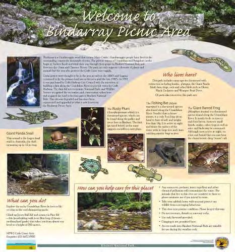
1 ROYAL GORGE PARK and RECREATION AREA A Feat of Natural and Man-Made Engineering
2 As Growth Resumed in the 1870 s Town Leaders Began to Envision a Tourist Industry. The Arkansas River Canyon was advertised to help lure visitors.

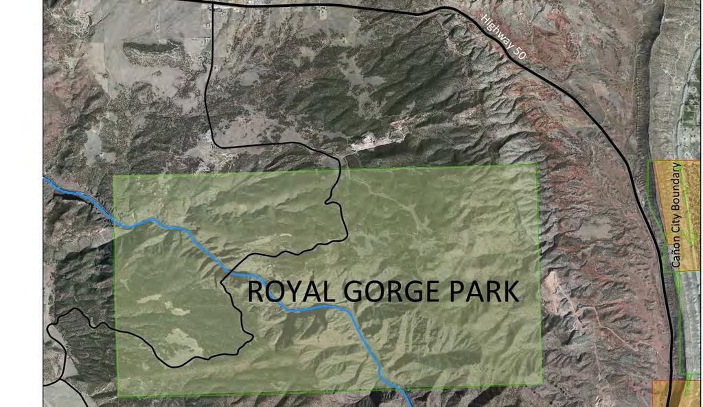
3 Future of the Royal Gorge Park The Royal Gorge Park is a roughly 5,000 acre property owned by the City of Cañon City. It is located 1.3 miles west of the City s boundary in unincorporated Fremont County, although it is actually 9.4 miles by vehicle. In April 2014 the City Council, with participation of many residents, developed a new Vision for Cañon City. From this Plan, a number of ideas and strategies to brand and improve the community were developed, including ideas for the Royal Gorge Park property. Currently, about 300-acres of the Park, or less than one (1) percent, is actively used. That area is leased to the Royal Gorge Company of Colorado. Within the 300-acre leased area are the Royal Gorge Bridge, a new visitor center, tram, zipline, Skycoaster swing, and other associated buildings. Also within the 300 acres is the Incline Railway, which will be inoperable for the foreseeable future due to damage sustained during a June 2013 wildfire. The June 2013 wildfire destroyed most of the facilities within the leased area of the Park. Prior to the fire, the facilities owned by the City but operated by the Royal Gorge Company of Colorado produced about $8.1 million in gross revenue. Of this amount, the City received about $1.6 million in revenue toward City operations. The City Council recognizes that to make many of the community improvements that council members agree are necessary, expanding the City s revenue base is imperative. The Royal Gorge Park is an underutilized asset that can help the City achieve this important objective. However, a Vision, proper amenities and quality throughout will be required.
4
 and the investment will need to complement the existing community. 3. Provide a.")
5 The new community Vision Plan states: 1. The community is a wealth of opportunity...and all of the authentic recreational opportunities in the region, with Cañon City the gateway to it all. 2. The City should invest in the City-owned land (Royal Gorge Park) and the investment will need to complement the existing community. 3. Provide a...wide range of authentic western experiences, including hiking, mountain bike trails, nature trails, etc. This likely should not be extreme sports if it is intended to attract a large family-oriented market, tourists, empty nesters, retirees, and a broad cross-section of the traveling market. This experience also should contribute to the quality of life of those who live in Cañon City. 4. The City should annex the land at the entrance to the Royal Gorge Park and establish land use regulations that would limit what uses could be built there. (Right now, the lower value rubber tomahawk market that exists there today is not a positive image for the visitor, nor is it supportive of a quality destination resort image.) Royal Gorge Bridge Company of Colorado in the implementation of the vision for the City-owned lands. The City may need to consider options to market the long-term vision of the Park consistent with that of the community, and begin developing the Park to complement a the new resort vision, such as: Develop a new destination resort on the city-owned land. Develop a new private development that will support investment for single and multi-family homes on the city-owned parcel. Develop a festival park and performance venue. Design and build a golf course and other on-site recreation venues. Develop an RV destination park. Develop a destination equestrian community. The purpose of this document is to help us imagine the evolution of the Royal Gorge Park as generally described in the Vision Plan. The Royal Gorge Recreation Center might be just one part of the overall property master plan. 5. The City should develop a master plan (long-term vision) for the entire city-owned land, consistent with the western theme and a national park quality. This master plan should focus on a vision that will eventually upgrade the operation of the leased Royal Gorge venue, with destinations spread throughout the property. Seek active participation and commitment on the part of the


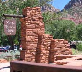
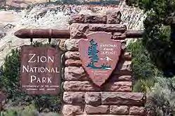
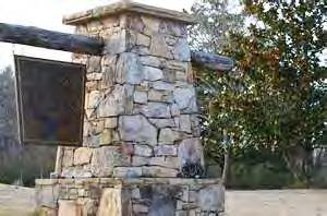
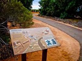
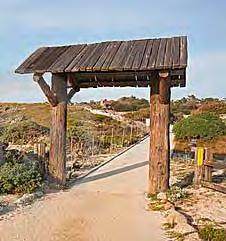
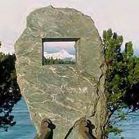
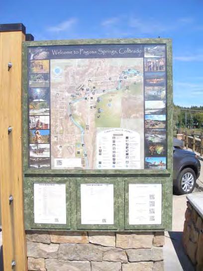
6 Park Entryway Character As stated in the Vision Plan, the activities within the leased area in the Royal Gorge Park have developed around a visitor experience that is catering to adventure and extreme sports, amusement and entertainment. As a result, the length of stay at the Park and in the community is short. Over time, the number of visitors has decreased. Following the June 2013 wildfire, the investment in new facilities appears to be directed again at amusement. In order for the Park to stimulate other activities in the area, the format for the Park, including the leased area, will need to evolve over time to a more national park visitor s experience. The Vision Plan notes that the lower value rubber tomahawk market in the vicinity of the Park today is not a positive image for the visitor; it is not supportive of a quality destination resort image; and it is not representative of National Park image or quality. Efforts should be made to begin changing the image of the Royal Gorge Park, from the front door and throughout the Park. Gateway Monment Welcome Signs Sign Forms that Represent the Morphology of the Gorge Extruded Letters Extruded and Stained Representation of Terrain Masonry Techniques


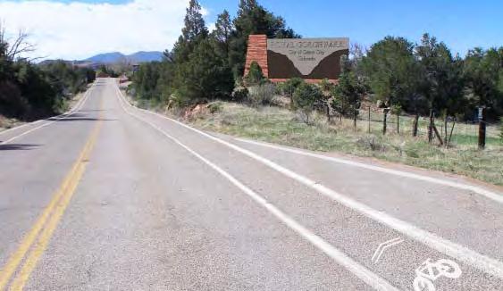
7 Change Entry Character from This To This Photo Pullout


8 Improve Message and Character of Park Directional Signs Replace Standard Highway Directional Signs


9 Future Design Vernacular of Park Buildings Architectural design is one way to upgrade the image of the Royal Gorge Park to National Park quality. Before the wildfire struck the Park in June 2013, buildings at the Park were comprised of a mix of designs and styles from 1930 to the present. The Park had begun to look worn and dated. A new standard or style should be established. It should be one that will stand the test of time; one that clearly reflects the region and the setting in which buildings/structures will be located. Openness and use of glass, native materials and stone, colors and roof lines that refect the surroundings and other design details should be given careful attention. While the vernacular can and should evolve over time to reflect technological changes and needs, the environmental, cultural, and historical context of the basic design should remain constant over time. As stated in the Vision Pan, our goal should be to envoke the image and quality of a National Park. Following the June 2013 fire, significant debate ocurred and effort was made to upgrade the character of the new visitor center at the Royal Gorge Bridge. This effort should be carried throughout in all future improvements in the Park. The photographs provided here are intended only to conjure up images of the design style and quality that could be achieved and maintained long-term at the Park. As a Master Plan is prepared for the Park, the desired design vernacular for the key public buildings should be identified and adopted as a guideline for future development and improvements.

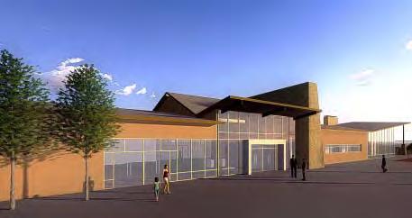
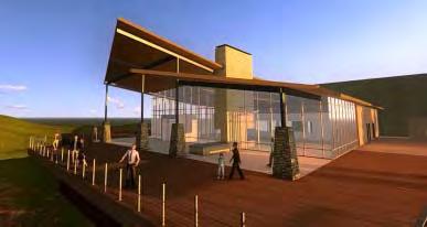
10 New Design Direction


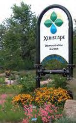
11 Use of Compatible Materials Integrating Design into Surrounding Environment Use of Windows to Bring Outdoor Environment Inside Appropriate Colors and Materials High Desert and Mountain Landscape and Low Water Design Carefully Consider Building Locations and Design Materials and Colors to Avoid Inappropriate Decisions That Will Have a Lasting Effect

12 The Royal Gorge Recreation Area As recommended in the Vision Plan, an active recreation area could be created at the Royal Gorge Park. The Royal Gorge Recreation Area should be both consistent with and integrated into the overall property master plan. The Recreation Center, which would be the hub for related activities, including restrooms, camping, hiking, biking, picnicking, winter sledding, nature experiences and other activities, should be designed so that the construction can be phased over time, as the master plan is completed and funds become available. Initially, basic services should be re-established after the fire, which might include restrooms, improved picnic and campground areas and signage. There should be a long-term commitment to the completion of the Royal Gorge Recreation Area and the Recreation Center. The Recreation Center can be a hub of learning and active recreation that attracts both residents and visitors state-wide and beyond to the Royal Gorge Park. The Recreation Center should provide for recreational opportunities year round. It is important that the Recreation Center not be a feature that competes with or detracts from the activities within the leased area of the Park. Rather, the recreational amenities and facilities offered should help bring more people to the Park and to the paid attractions within the leased area. It should help to promote extended stays locally, which will benefit the entire community.


13 Concept Site Plan Information Desk and Camping Check-in
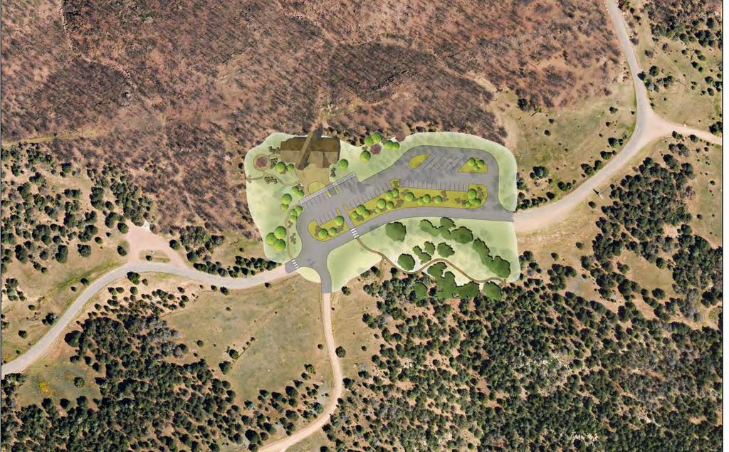
14

15 Royal Gorge Recreation Area Concept Trail Plan Trail Connection to Cañon City Trail Connection to Cañon City Incline Trail Connection with Tunnel Drive Trail


16 The Nature and Learning Center The Nature and Learning Center could be an amenity that is incorporated into the Recreation Area concept. It should be accessible to people of all ages and provide a one-of-a-kind adventure, where visitors can experience animals and plants from both the past and now native to the Royal Gorge Region. The Nature and Learning Center could also disseminate information about the cultural heritage of the Region and create connections to the various museums in Cañon City. In fact, the Center could be an extension of local museum operations that now occur near downtown. Ideally, it would be a hands-on learning center, offering living history demonstrations, interpretive programs, exhibits, multi-media presentations, special events, and trails within the Recreation Area that specifically offer interpretive displays and information. Plant and Wildlife of the Royal Gorge Region Interactive Displays - How the Royal Gorge Was Formed


17 Local Paleontology Link the message to other local museums, quarries and parks Local Natural and Cultural History Displays

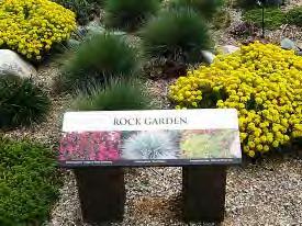
18 Trail Heads and Intrepretation Trail Head Markers Intrepretation and Education Creative Approaches Quality Trail Maps Demonstration and Education Areas


19 Hiking and Equestrian Trails Trails for all ages and abilities Equestrian Trails Scenic Overlook Trails Picnic Areas Incline Trail from Tunnel Drive Trail to Fremont Peak


20 Linking the Train and Recreation Area In the future, the opportunity to connect the community, the Royal Gorge Route Railroad and the Royal Gorge Park and Recreation Area should be explored. As the Incline Railway is repaired and brought back into operation, consideration should be given to linking the community, the Train, the Park and recreational activities at the Park into a seamless experience. Recreational Passengers and Bicycles carried aboard the Train Transporting Visitors and Bicycles between the Train and Park via the Incline Railway


21 Mountain Biking and Challenge Courses Challenge Courses Mountain Bike Trails Road Bike Paths Organized Mountain Bike Events
22 Available Nearby: Fishing Technical Rock Climbing Horseback Riding Camping Whitewater Rafting and Kayaking Tourist Train Excursions Hunting ATV and Jeep Tours Year Round Festivals Helicopter Tours Wineries Dining Shopping Geocaching Golf Museums Rodeo Sightseeing
CHAPTER 5. Chapter 5 Recreation Element
 CHAPTER 5 Recreation Element Chapter 5 Recreation Element The Recreation Element of the Meyers Area Plan is a supplement to the Recreation Element of the TRPA Regional Plan and the El Dorado County General
The Vision for the San Juan Islands Scenic Byway
 The Vision for the San Juan Islands Scenic Byway 2 Judd Cove, Orcas Island, Courtesy of Kurt Thorson (kurtthorson.com) and San Juan County Land Bank Vision for the San Juan Islands Scenic Byway The San
NAVAJO COMMUNITY PLAN
 NAVAJO COMMUNITY PLAN Prepared by the NAVAJO COMMUNITY PLANNERS and THE CITY OF SAN DIEGO City of San Diego Planning Department 202 C Street, MS 4A San Diego, CA 92101 Printed on recycled paper. This information,
System Group Meeting #1. March 2014
 System Group Meeting #1 March 2014 Meeting #1 Outcomes 1. Understand Your Role 2. List of Revisions to Existing Conditions 3. Information Sources Study Area The Purpose of Mountain Accord is to Preserve
South Canon City Center
 South Canon City Center Canon City s Golden Triangle Thank you, Mr. Mayor, City Council and City Administration, for the opportunity to address you. I have a vision to share with you, regarding the recovery
13.1 REGIONAL TOURISM ISSUES AND SUMMARY OF FINDINGS
 13 REGIONAL TOURISM T he County of Mariposa s recreation needs and facilities fall within two categories: regional tourism and local recreation. This Element focuses on regional tourism issues related
Silver Lake Park An Environmental Jewel for the Citizens of Prince William County
 Silver Lake Park An Environmental Jewel for the Citizens of Prince William County The Prince William Park Authority Mission Statement states: The Prince William County Park Authority will create quality
Village of Taos Ski Valley 2015 Master Plan. Recreation Element
 Village of Taos Ski Valley 2015 Master Plan Taos Ski Valley is known across the world for skiing and winter sports, but the Village has more to offer than advanced skiing terrain and short lift lines.
COLORADO STATE PARKS NORTHWEST REGION RON VELARDE NORTHWEST REGIONAL MANAGER
 COLORADO STATE PARKS NORTHWEST REGION RON VELARDE NORTHWEST REGIONAL MANAGER COLORADO STATE PARKS NORTHWEST REGION HIGHLINE LAKE JAMES M. ROBB COLORADO RIVER VEGA RIFLE COMPLEX SYLVAN LAKE STAGECOACH STATE
FY19 Colorado Tourism Office Marketing Matching Grant Recipients
 $25,000 Colorado Campground and Lodging Owners Association A marketing plan centered on the Camp Colorado Guide, and expanding the use of digital marketing and social media channels in order to inspire
Rogue River Access and Management Plan Draft Alternatives
 Rogue River Access and Management Plan Draft Alternatives The Rogue River Access and Management Plan was initiated in December, 2011 and is being led by Jackson County Parks (JCP) and Oregon Department
Chapter 6: POLICY AND PROCEDURE RECOMMENDATIONS
 Chapter 6 POLICY AND PROCEDURE RECOMMENDATIONS FOR SRRA Below are seven policy elements that should be considered for adoption by the Southwest Regional Recreation Authority of Virginia: 1. Develop strategies
MASTER PLAN EXECUTIVE SUMMARY
 Biscuit Run State Park Scottsville Road (State Route 20) Charlottesville, VA 22902 Biscuit Run State Park MASTER PLAN EXECUTIVE SUMMARY Department of Conservation and Recreation Division of Planning and
Blueways: Rivers, lakes, or streams with public access for recreation that includes fishing, nature observation, and opportunities for boating.
 Parks, Open Space and Trails PRINCE WILLIAM COUNTY 2008 COMPREHENSIVE PLAN TRAILS PLAN CONTENTS The components of the trails plan are: Intent Definitions Goals, Policies, and Action Strategies Trails Map
Colorado Springs & Pikes Peak Region Destination Master Plan
 Colorado Springs & Pikes Peak Region Destination Master Plan Overview June 19, 2018 DESTINATION MASTER PLAN What is Destination Master Planning? Focus on infrastructure, facilities, services, attractions
OPEN HOUSE PRESENTATION
 Thank You For Attending Today Capital District Transportation Committee Behan Planning and Design The Chazen Companies Engineering Sidekick Creative C onsultecon, Inc. R obert B engraff Drone Pilot What
These expenses are mainly on gear, vehicles, trips, travel-related expenses and more.
 Americans are increasingly acknowledging the benefits of outdoor recreation: personal health and wellbeing; economic value; aesthetics; community wellbeing; and business opportunities. $646 billion direct
ADVENTURE PLAN EXPLORE PARK
 ADVENTURE PLAN ROANOKE COUNTY S EXPLORE PARK ROANOKE COUNTY PARKS, RECREATION AND TOURISM 1206 KESSLER MILL RD SALEM, VA 24153 (540) 387-6078 WHAT S INCLUDED? Explore Park Adventure Plan - Guided by extensive
Town of Limon Comprehensive Plan CHAPTER 6 TOURISM AND THE VISITOR ECONOMY
 CHAPTER 6 TOURISM AND THE VISITOR ECONOMY 65 VISION Limon s location at the intersection of Interstate 70, and Highways 24, 40, 71, and 287, provides steady traveler traffic with an estimated 80,000 overnight
The Recreational Trail along Cushing Park road has been a successful addition to the city
 The Recreational Trail along Cushing Park road has been a successful addition to the city Trails TRAILS, PATHS, ROUTES AND CONNECTORS Citizen input pointed to trails, paths, bike routes, and other non-motorized
The Airport. p a g e 2
 The Airport Telluride Regional Airport (TEX) with a runway altitude of 9,070 feet MSL is the highest airport in North America with commercial service in light of the fact that, after a two-year hiatus,
LAND USE GUIDELINES NEW TOWN
 VI LAND USE A L T ETruRck TNraiAl T I V E S AarNnelDla D E S I G N W GUIDELINES NEW TOWN ad Ro DAVEN CA LF IRE ALTERNATIVE LAND USE PLANS AND DESIGN GUIDELINES - VI VI LAND USE ALTERNATIVES Asilomar Hotel
Dungeness Recreation Area County Park Master Plan
 Dungeness Recreation Area County Park Public Outreach Meeting October 10, 2007 Project Overview USFWS Site Dungeness Recreation Area County Park Meeting Objectives: Re-Introduce project; provide status
Logo Department Name Agency Organization Organization Address Information 5700 North Sabino Canyon Road
 Logo Department Name Agency Organization Organization Address Information United States Forest Coronado National Forest 5700 North Sabino Canyon Road Department of Service Santa Catalina Ranger District
EXECUTIVE SUMMARY PROGRAM DEVELOPMENT REPORT PURPOSE EXISTING SETTING EXPANDING PARKLAND
 EXECUTIVE SUMMARY PROGRAM DEVELOPMENT REPORT PURPOSE As the culmination of the first phase of the master planning process, this Program Development Report creates the framework to develop the Calero County
Regional Wayfinding Sign Strategy Thurston County Trails 2017
 Regional Wayfinding Sign Strategy Thurston County Trails 2017 Partners: Members and partnering organizations of the Thurston Thrives Community Design Action Team City of Lacey, City of Olympia, City of
Map 1.1 Wenatchee Watershed Land Ownership
 Map 1.1 Wenatchee Watershed Land Ownership Map 1.1 Wenatchee Watershed Land Ownership The Wenatchee watershed lies in the heart of Washington state in Chelan County. Just larger than the state of Rhode
City of Durango 5.8 FUNDING TRAILS DEVELOPMENT
 5.8 FUNDING TRAILS DEVELOPMENT The City has been successful in establishing dedicated local funding sources as well as applying for grants to develop the City s trail system, having received nearly $2.4
±30.68 Gross Acres of Land Available
 ±30.68 Gross Acres of Land Available SEC of Galleria Drive (Hacienda Avenue) and Highest Wolf Lane in Henderson, Nevada GALLERIA AT SUNSET MALL UNION VILLAGE LAS VEGAS STRIP DOWNTOWN LAS VEGAS CADENCE
Ride South Canyon Trails. Bunk House Burgers. Ride Royal Gorge Park Trails. Sustainability Activity
 Published on Colorado.com (https://www.colorado.com) Mountain-Bike Adventures in Cañon City 3 days More Itineraries Experience epic downhill thrills with some of south-central Colorado's most spectacular
Tahoe Donner Association Public Scoping Meeting DUDEK
 Tahoe Donner Association Public Scoping Meeting DUDEK Introduction Purpose of this Meeting: Solicit feedback and ideas from members, and staff as we begin the Association Master Plan. Association Master
EVENT CENTRE / ARENA COMPLEX
 EVENT CENTRE / ARENA COMPLEX BUSINESS CASE ANALYSIS PRESENTATION TO COUNCIL JANUARY 14, 2019 PART A: PROJECT RECAP PART B: DETAILED ASSESSMENT OF THE FACILITY OPTIONS PART C: COMPARING THE OPTIONS PART
HOSPITALITY FOR SALE. 222 Kern River Highway, Kernville, CA FULLY OPERATIONAL 20-ROOM MOUNTAIN RESORT + DEVELOPMENT LAND PROPERTY FEATURES
 SALE PRICE: $1,950,000 LOT SIZE: 19.01 Acres BUILDING SIZE: 9,489 SF 2016 GROSS REVENUE: $246,000 EXISTING MOTEL PARCEL: 228,254 SF FUTURE MOTEL PARCEL: 357,192 SF FUTURE RV PARCELS: 242,629 SF ZONING:
O REGON TRAILS SUMMIT. Oregon Trails Summit. Rogue River National Forest
 O REGON TRAILS SUMMIT Oregon Trails Summit 2014 Rogue River National Forest OREGON TRAILS 2015: A VISION FOR THE FUTURE The 2015-2024 Oregon Statewide Trails Plan Why do a trails plan? 2005-2014 Oregon
Thank you for this second opportunity to comment on the proposed revisions to the Coconino National Forest Management plan.
 March 8, 2011 Flagstaff Biking Organization PO Box 23851 Flagstaff, AZ 86002 Yewah Lau Coconino National Forest Attn: Plan Revision 1824 South Thompson Street Flagstaff, Arizona 86001 Sent via electronic
Welcome to the future of Terwillegar Park a Unique Natural Park
 Welcome to the future of Terwillegar Park a Unique Natural Park 1 Introduction The Terwillegar Park Concept Plan study will develop an overall concept plan, management objectives and development guidelines
5.0 OUTDOOR RECREATION OPPORTUNITIES AND MANAGEMENT
 5.0 OUTDOOR RECREATION OPPORTUNITIES AND MANAGEMENT 5.1 Introduction This section describes the range of recreational activities that currently take place in Marble Range and Edge Hills Parks, as well
COUNTY COMPREHENSIVE PLAN
 50 : Policy Statement Lewis County has a unique and attractive rural character, which makes it a wonderful place to visit and explore. The region abounds with recreation opportunities that attract visitors
LANDING S PARK CONCEPTUAL PLAN HAMILTON ANDERSON JANUARY City of Novi, Michigan. The Park at 13 Mile and Old Novi Road
 HAMILTON ANDERSON JANUARY 2012 LANDING S PARK CONCEPTUAL PLAN January 2012 Page 1 of 15 January 2012 PROJECT GOALS Activate the park by introducing new elements Provide clear access to the water and enhance
National Parks and Beyond
 National Parks and Beyond Canyons, Mesas and Hoodoos Nevada Utah Arizona Red Rock Canyon National Conservation Area Las Vegas, Nevada Begin your adventure under the neon lights of Las Vegas, an oasis in
THE UNITED TOWER COMMERCIAL OFFICES RETAIL SPACE BAHRAIN BAY NOW LEASING
 THE UNITED TOWER BAHRAIN BAY COMMERCIAL RETAIL SPACE NOW LEASING THE UNITED TOWER BAHRAIN BAY A SPIRAL CITY MIXED USE DEVELOPMENT The United Tower was conceived as a building with multiple uses: a vertical
Beth Lucas, Senior Planner Stephanie Brewer, Planner Broome County Planning May 12 th, 2016
 Beth Lucas, Senior Planner Stephanie Brewer, Planner Broome County Planning May 12 th, 2016 Background Data Collection Trail Mapping Promotional Strategy December 2014 County s natural beauty identified
CONTENTS. 1 Introduction Always Moving Forward while Building on the Past A Dynamic Destination... 5
 2010 STRUCTURE PLAN - 2 - CONTENTS 1 Introduction... 5 1.1 Always Moving Forward while Building on the Past... 5 1.2 A Dynamic Destination... 5 2 Map A... 6 Exhibition Place and its Neighbours... 7 3 Demonstration
Chapter 6. Trail Design. Trail Design
 Chapter 6 Trail Design Trail Design The trail winds through a region rich in scenic beauty, cultural, and natural history. Volunteer landscape architects working with the Core and Planning Teams, have
!!! THE ESSENCE OF COLORADO COUNTRY ESTATE LIVING IN A QUINTESSENTIAL LOCATION.
 THE ESSENCE OF COLORADO COUNTRY ESTATE LIVING IN A QUINTESSENTIAL LOCATION. AN UNOBTRUSIVE BUT NOTICEABLE STATEMENT OF TASTE, QUALITY AND SOPHISTICATION. By Active Capital Partners An Overview Enjoy
Restore and implement protected status that is equivalent, or better than what was lost during the mid-1990 s
 THE ROSSLAND RANGE, OLD GLORY AREA. Executive summary. The Friends of the Rossland Range Society, on behalf of the local outdoor community, seeks to accomplish the following with respect to the Old Glory
Proposal to Redevelop Lower Kananaskis River-Barrier Lake. Bow Valley Provincial Park. Frequently Asked Questions
 Proposal to Redevelop Lower Kananaskis River-Barrier Lake Bow Valley Provincial Park Frequently Asked Questions What is being proposed? What are the details of the proposal? Where is the project area located?
About the Airport. Commercial Aviation. Corporate & General Aviation
 About the Airport The Colorado Springs Airport (COS) is a city-owned, public-use commercial airport located at the heart of Colorado and is the primary-use airport for the Pikes Peak Region and Southern
Wilds. Headwaters. Lakes. Oxbows. Falls
 56 5 4 3 Wilds Headwaters Lakes Oxbows Falls 57 Zones It could be said the on-the-ground essence of this master plan appears within the next 6 pages of this report. As we learned in the preceding Cultural
Lane Residence. Silverthorne, Colorado. Offered for $3,999,999. Contact Bill George. (970)
") Lane Residence Silverthorne, Colorado Offered for $3,999,999 Contact Bill George (970) 485 1052 bill@ranchland.com Ownership of this 6,450 square foot custom log home at Shadow Creek Ranch gets you access
Lane Residence Silverthorne, Colorado Offered for $3,999,999 Contact Bill George (970) 485 1052 bill@ranchland.com Ownership of this 6,450 square foot custom log home at Shadow Creek Ranch gets you access
PROPOSED PARK ALTERNATIVES
 8 Chimne y Rock State Park M a ster Pl an 2011 PROPOSED PARK ALTERNATIVES Introduction Three different park development concepts were prepared and presented to the citizens of North Carolina through a
ELEPHANT BUTTE LAND 640 Acres of pristine land surrounded by BLM property Next to Coral Pink Sand Dune Area Southern Utah INVESTMENT OFFERING
 640 Acres of pristine land surrounded by BLM property Next to Coral Pink Sand Dune Area Southern Utah PROPERTY DESCRIPTION Nestled within one of Southern Utah s picturesque red cliff valleys, with spectacular
Flow Stand Up Paddle Board Parkway Plan Analysis
 Regional Parks Department Jeffrey R. Leatherman, Director County of Sacramento Divisions Administration Golf Leisure Services Maintenance Rangers Therapeutic Recreation Services Flow Stand Up Paddle Board
F INAL DESIGN PROPOSAL. Knife River Village MASTER PLAN
 Knife River Village MASTER PLAN The Knife River Village idea is the culmination of the community design process with as much community feedback incorporated as possible into the final design proposal.
PORT GAMBLE HERITAGE PARK
 PORT GAMBLE HERITAGE PARK PARTNERS A Kitsap County Project with non-profit partners: Kitsap County Parks Foundation, administered by Kitsap Community Foundation Visit Kitsap Peninsula Evergreen Mountain
Central Texas. Country Clubs & Resorts
 Central Texas Country Clubs & Resorts Central Texas Country Clubs and Resorts 5 2 46 25 20 9 28 6 27 Ranch Rd. 2 7 6 Ranch Rd. 2 620 26 7 2 3 23 24 826 3 8 8 3 620 2222 0 2 5 4 9 4 2 22 95 95 The country
About the Airport. Commercial Aviation. Corporate & General Aviation
 About the Airport The Colorado Springs Airport (COS) is a city-owned, public-use commercial airport located at the heart of Colorado and is the primary-use airport for the Pikes Peak Region and Southern
ADVENTURE. Activities Offerings ADVENTURE
 Activities Offerings ADVENTURE ADVENTURE Situated on 4,200 acres with 5,000 additional acres of private wilderness, Blackberry Farm is its own unique piece of private wilderness, but surrounding the farm
Alpine Trails Mountain Community Development Lands
 FOR SALE Residential Development Land 228 ± Acres V.T.B. FINANCING AVAILABLE! Size: 228 +/- Acres Zoning: R1B and R3 Price: $7,700,000 CAD ($33,772.00 /Acre) Alpine s Mountain Community Development Lands
Stephens Rd. Nature Preserve
 Stephens Rd. Nature Preserve History Stephens Road Nature Preserve (SRNP) is a 350-acre nature preserve in Huntersville that comprises nine properties purchased between 1994 and 2008. Parcels included
Proposal to Redevelop Lower Kananaskis River-Barrier Lake. Bow Valley Provincial Park
 Frequently Asked Questions Proposal to Redevelop Lower Kananaskis River-Barrier Lake Bow Valley Provincial Park Frequently Asked Questions What has been decided? What are the details of the plan? What
Chapter 1: Introduction
 Chapter 1: Purpose of the Comprehensive Plan The purpose of the Comprehensive Plan of the City of Rockaway Beach is to provide a policy guide for the growth and future development of the City. Section
National Recreation Trail Update Form
 National Recreation Trail Update Form Introduction Thank you for taking the time to complete this form. Your assistance will help ensure that the National Recreation Trail (NRT) database is complete and
Wildlife and Wonder. Exploring Yellowstone and Grand Teton National Parks. 6 Days / 5 Nights DEVELOPED FOR. Couples and Families HIGHLIGHTS
 6 Days / 5 Nights DEVELOPED FOR Couples and Families HIGHLIGHTS Full Day Private Guided Tour of Yellowstone National Park Jackson Lake Lodge One-hour horseback ride Private Morning Wildlife Tour of Grand
Welcome Letter Explorers Welcome Economics & Tourism Regions Map Contacts
 Outline Welcome Letter Explorers Welcome Economics & Tourism Regions Map Contacts Explorers Welcome Welcome Letter Distinguished members of the press, We d like to introduce you to Explore Butte County!
AMERICAN S PARTICIPATION IN OUTDOOR RECREATION: Results From NSRE 2000 (With weighted data) (Round 1)
 (Round 1)") AMERICAN S PARTICIPATION IN OUTDOOR RECREATION: Results From NSRE 2000 (With weighted data) (Round 1) The emphasis of this report is on participation patterns across activities and segments of our society.
AMERICAN S PARTICIPATION IN OUTDOOR RECREATION: Results From NSRE 2000 (With weighted data) (Round 1) The emphasis of this report is on participation patterns across activities and segments of our society.
TRAIL DATABASE SCHEMA (8/26/2014)
") Trail Data Model for LINES Source Data Source Agency dataagency Agency or entity that created the dataset where the original line was sourced from. Source Date of Last Data Used to Update sourcedate Publication
Trail Data Model for LINES Source Data Source Agency dataagency Agency or entity that created the dataset where the original line was sourced from. Source Date of Last Data Used to Update sourcedate Publication
This is a submission to Council s Delivery Plan and Operational Plan
 Goulburn Mulwaree Council Locked Bag 22 Goulburn NSW 2580 Emailed: strategy@goulburn.nsw.gov.au and council@goulburn.nsw.gov.au Marulan/Tallong Community Network C/O 843 Marulan South Road Marulan NSW,
Section II. Planning & Public Process Planning for the Baker/Carver Regional Trail began in 2010 as a City of Minnetrista initiative.
 Section II Planning & Public Process Planning for the began in 2010 as a City of initiative. city staff began discussions with the Park District on the possibility of a north/south regional trail connection
THE AIRTRAIN AIRPORT ACCESS SYSTEM JOHN F. KENNEDY INTERNATIONAL AIRPORT AIRPORT ACCESS SERVICE
 THE AIRTRAIN AIRPORT ACCESS SYSTEM JOHN F. KENNEDY INTERNATIONAL AIRPORT AIRPORT ACCESS SERVICE The JFK AirTrain airport access system interfaces with two existing regional transit systems; the Long Island
Part Three : COMMUNITY PLAN AREAS AND SPECIAL STUDY AREAS SACRAMENTO 2030 GENERAL PLAN. Introduction
 Special study Areas Part Three : COMMUNITY PLAN AREAS AND SPECIAL STUDY AREAS SACRAMENTO 2030 GENERAL PLAN Introduction Beyond the boundaries of the 2030 General Plan, the City has defined Special Study
A. SHAPING RECREATION DESTINATIONS
 A. SHAPING RECREATION DESTINATIONS Shaping SLV Communities into Recreation Destinations Great trails and recreation opportunities don t just satisfy local athletes, they can also attract tourists, boost
Economic Development and Tourism
 SECTION 4 SECTION 4 Economic Development and Tourism 4. Economic Development and Tourism Tourism plays a very important role in Niagara s economy, providing employment and generating business for support
Cascade River State Park Management Plan Amendment
 This document is made available electronically by the Minnesota Legislative Reference Library as part of an ongoing digital archiving project. http://www.leg.state.mn.us/lrl/lrl.asp Cascade River State
Appendix A BC Provincial Parks System Goals
 Appendix A BC Provincial Parks System Goals The British Columbia Provincial Parks System has two mandates: To conserve significant and representative natural and cultural resources To provide a wide variety
A Vision for South Skunk River and Chichaqua Bottoms Greenbelt
 A Vision for South Skunk River and Chichaqua Bottoms Greenbelt Photo: Jim Pease Chichaqua Bottoms Booklet 7 of 8 Greater Des Moines Water Trails and Greenways 1 2016 Table of Contents Booklet 1: Water
Alpine Trails Mountain Community Development Lands Fernie, British Columbia Winter 2018
 FOR SALE Residential Development Land 228 ± Acres Size: Zoning: Price: 228 +/- Acres R1B and R3 $7,700,000 CAD ($33,772.00 /Acre) $6,055,000 USD ($26,557.00 /Acre) Alpine s Mountain Community Development
CHAPTER FIVE PROSPECTS FOR FUTURE ECONOMIC DEVELOPMENT
 CHAPTER FIVE PROSPECTS FOR FUTURE ECONOMIC DEVELOPMENT 5.1 GENERAL The recommended type and location of future land uses in Alpine should, in part, consider potential opportunities for future economic
Pier Enhancements April 6, 2017
 Pier Enhancements April 6, 2017 Pier Enhancement Categories Pier Plaza Improvements Contingency Play Elements Destination Differentiators Water Recreation Zone Furniture, Fixtures & Equipment Transportation
Downtown Revitalization Tomball, Texas. Presented By: Mayor Gretchen Fagan City of Tomball
 Downtown Revitalization Tomball, Texas Presented By: Mayor Gretchen Fagan City of Tomball Downtown defines our community! Brings people together central gathering space Economic Opportunity increased property
Airport Planning Area
 PLANNING AREA POLICIES l AIRPORT Airport Planning Area LOCATION AND CONTEXT The Airport Planning Area ( Airport area ) is a key part of Boise s economy and transportation network; it features a multi-purpose
GRAND TETON NATIONAL PARK. GRAND TETON LODGE COMPANY Part of Something Bigger
 GRAND TETON NATIONAL PARK GRAND TETON LODGE COMPANY Part of Something Bigger Where Grand Adventure Begins TURNS OUT EVERYONE SEES the big picture a little differently. GRAND TETON LODGE COMPANY Grand Teton
Chatsworth Branch Library Devonshire Street, Chatsworth, CA Thursday, November 16, :00-8:00 pm
 Chatsworth Branch Library 21052 Devonshire Street, Chatsworth, CA 91311 Thursday, November 16, 2017 6:00-8:00 pm Project Team County of Los Angeles Department of Parks and Recreation Kathline King Chief
National Scenic Byways Program US Department of Transportation
 1 2 National Scenic Byways Program US Department of Transportation Abstract The Cowlitz-Wahkiakum Council of Governments in partnership with Cowlitz, Skamania and Lewis Counties and the U.S. Forest Service,
National Recreation Trail Application for Designation
 National Recreation Trail Application for Designation Introduction Thank you for your interest in the National Recreation Trail (NRT) program. Completed NRT application packages must be submitted by December
Land Management Summary
 photo credit: ANGAIR Anglesea Heath Land Management Summary The Anglesea Heath (6,501 ha) was incorporated into the Great Otway National Park in January 2018. This provides an opportunity to consider the
Downtown Hotel Development
 Downtown Hotel Development Emerging Opportunities for Small & Medium Size Cities National Extension Tourism Conference, June 15, 2009 Bill Ryan, University of Wisconsin-Extension Bill Way, University of
Visitor Management Plan innovative and hospitable
 Visitor Management Plan 2015-2020 innovative and hospitable Outline of policy, objectives, and enabling conditions Drawn up on 19 March 2015 1. Introduction The Visitor Management Plan 2015-2020 outlines
2321 Filbert Street OAKLAND. O f f e r i n g M e m o r a n d u m. EXCLUSIVE AGENT TOM SOUTHERN CA RE License #
 2321 Filbert Street OAKLAND O f f e r i n g M e m o r a n d u m EXCLUSIVE AGENT TOM SOUTHERN 510.923.9158 tsouthern@ngkf.com CA RE License #01808807 EXECUTIVE SUMMARY Newmark Knight Frank is pleased to
CAIRNS RECTANGULAR PITCH STADIUM NEEDS STUDY PART 1 CAIRNS REGIONAL COUNCIL DRAFT REPORT SEPTEMBER 2011
 CAIRNS RECTANGULAR PITCH STADIUM NEEDS STUDY PART 1 CAIRNS REGIONAL COUNCIL DRAFT REPORT SEPTEMBER 2011 CAIRNS RECTANGULAR PITCH STADIUM NEEDS STUDY PART 1 Cairns Regional Council September 2011 Coffey
Sponsorship & Partnership Opportunities
 Atherton Tablelands About Us Atherton Tablelands Promotion Bureau Limited was established in 1986 under the auspice of the former four Local Government Authorities governing the geographic region of the
Private Cabin - Boone 15 min - Hot Tub - WiFi - Hiking - Specials
 Private Cabin - Boone 15 min - Hot Tub - WiFi - Hiking - Specials Summary Deer Run offers a very secluded natural wooded setting. Located on a unique 78 acres with hiking trails, trout stream and waterfalls.
Stevenson Ranch Library The Old Road, Stevenson Ranch, CA Thursday, November 9, :00-8:00 pm
 Stevenson Ranch Library 25950 The Old Road, Stevenson Ranch, CA 91381 Thursday, November 9, 2017 6:00-8:00 pm Project Team County of Los Angeles Department of Parks and Recreation Kathline King Chief of
Lake Placid Assessment Updated November 2008
 Lake Placid Assessment Updated November 2008 Intro Statement Years ago, Lake Placid took its tourism future in its own hands. It took a blossoming Adirondack resort destination and went out and convinced
±12.29 Acres of Lake Frontage Land
 ±12.29 Acres of Lake Frontage Land Located on 70 Strada di Villagio in the Premier Lake Las Vegas Community $6,200,000 GALLERIA AT SUNSET MALL UNION VILLAGE LAS VEGAS STRIP DOWNTOWN LAS VEGAS CADENCE MASTER
Destination Management Planning
 Destination Management Planning 12 March 2013 DMP: A VET priority Destination Management Plans: Key visitor destinations across the State need a Destination Management Plan To provide a means of understanding
Welcome to The Town of Winfield SCOTT COUNTY, TN
 SCOTT COUNTY, TN Photo Tour and Recommendations The focus of Scott County tourism is as the Tennessee Gateway to the Big South Fork National Park, which is by far the largest tourism attractor to the region.
Tourism Development Framework for Scotland. Executive Summary- Development Framework to 2020 for the Visitor Economy (Refresh 2016)
") Tourism Development Framework for Scotland Executive Summary- Development Framework to 2020 for the Visitor Economy (Refresh 2016) Introduction The Tourism Development Framework for Scotland refresh 2016:
Tourism Development Framework for Scotland Executive Summary- Development Framework to 2020 for the Visitor Economy (Refresh 2016) Introduction The Tourism Development Framework for Scotland refresh 2016:
10,100 People reside in North Perth
 ACTION PLAN THE HISTORY TODAY North Perth was subdivided as early as 1898. In March 1899, the area was declared North Perth Road District and was gazetted as a municipality in 1901. Housing in the area
Visitor Profile - Central Island Region
 TOURISM LABOUR MARKET RESEARCH PROJECT 2003 The Project The Tourism Labour Market Research Project, was designed to study the tourism labour market throughout the Vancouver Island region. The Visitor Survey