F INAL DESIGN PROPOSAL. Knife River Village MASTER PLAN
|
|
|
- Julius Fowler
- 5 years ago
- Views:
Transcription

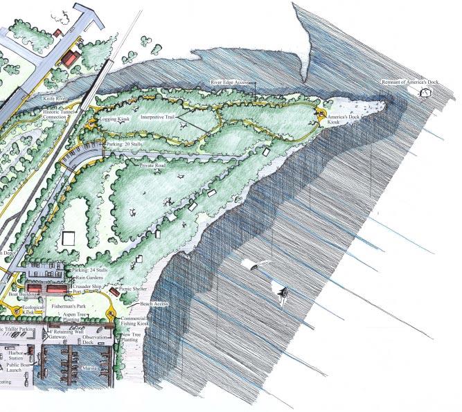
1 Knife River Village MASTER PLAN The Knife River Village idea is the culmination of the community design process with as much community feedback incorporated as possible into the final design proposal. During the course of the design work the campground location was sold and will continue to be opperated as a campground. The design focus then shifted from the campground area to the rail authority land and the KRRC land. These new parcels lent them selves well to the programs dervied by the group but were removed from the scenic drive and had no visual access. Reworking the main intersection became a priority. With changes in paving pattern, new plantings, ballards, and sidwalks a variety of landscape features lead people up towards the marina, rest stop and boat building area (shown in perspective drawings, following pages). New connections have been made with the creation of an interpretive trail. This trail effectively accesses the historic rail underpass, river, rocky point(views of Americas dock, KRRC, Rest Stop, and beach area. Kiosks would occur through out the trail, offering historic, cultural, and environmental interpretation at key locations. The Rest Stop uses a renovated historic Depot and service building. It also serves as a stop for the scenic train from Duluth to Two Harbors. This could become a new stop on the line bringing visitors into Knife River. The KRRC land is developed as a space for the Crusader and new community boat building. This new structure could be used for a variety of community events and serve as a regional center for boat builders. Education, tours, sales, and other contact information could be housed here as this center would become a house and public face for the many speciality boat builders on the North Shore.
2
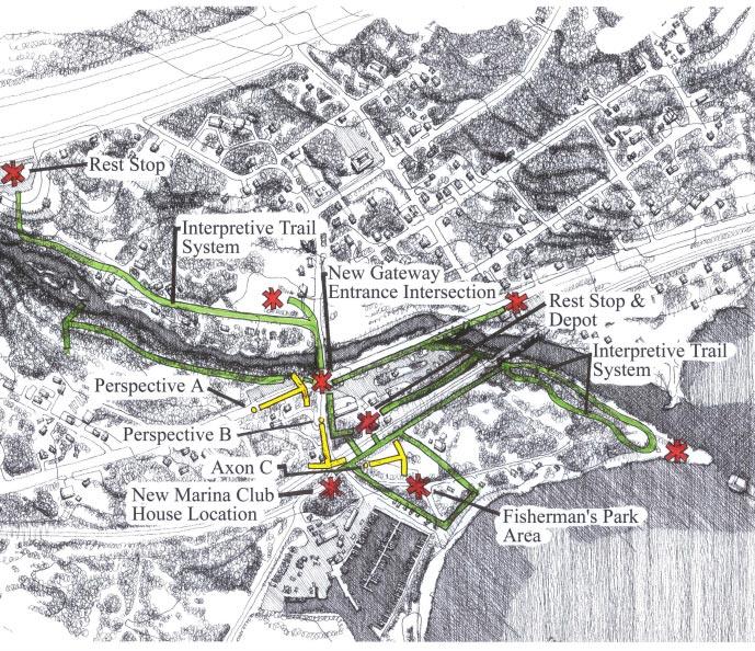
3 DIAGRAMMATIC REPRESENTATION OF PLAN The Interpretive Trail System Key Locations Along the Trail Illustrative Views (following pages) This diagram shows how the interpretive trail links the key features within Knife River. Some of these key locations are the locations of the new marina, rest stop, boat building KRRC land, and intersections taking people to the areas.
4
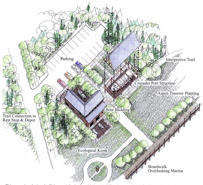
5 The Fisherman s Park & Marina Key Location This axonometric view depicts the Fisherman s Park Area with a proposed Boat Building Center and port for the historic commercial fishing vessel the Crusader. The boat center is conceived as a place to conduct workshops on boat building, recreational boating, as a carry-in location for sea kayaking, and a centralized location for the dispersal of information pertaining to recreational boating and the regional resource for such activity. Swing or convertible space inside the facilities could support club meetings and facilities for outfitters. The setting is fitting with the return of the Crusader to Knife River and the open space park allows visitors prime beach access. The space is well connected to other Knife River amenities via a Boardwalk and viewing platforms over the Marina. Other important connections are provided by trails to the rest stop, and by local streets to Knife River itself. The boardwalk succesfully creates seperation from the public open space and the private areas of the marina while providing views into the marina and marina activity. The interpretive trail connects the KRRC land, Boat building, marina and rest stop. An interpretive Kiosk is located here and could provide historic and cultural information on the commercial fishing industry of Knife River.
6

7 Perspective Views of Key Locations THE GATEWAY LOCATION This view shows how this key intersection can be turned into a gateway that directs people to turn up to the rest stop, fisherman s park, and the marina. The use of different paving patterns, timber bollards, signage, and new side walks leads visitors to the activity areas. Additional spruce planting is used to create a backdrop to heighten the impact of the improvements.


8 THE FISHERMAN S PARK ENTRY & MARINA A strong axial arrangement and continued signage leads visitors from the gateway intersection into the activity area. Notice how the details can be used to create the ambience of village or sea town.

9 Design Details INTERPRETIVE KIOSK FOR KNIFE RIVER The kiosk design is influenced from Scandinavian architecture. It reflects the cultural heritage of the people and founders of Knife River Village. The high pitched roof lines and wood detailing reflects structures typically seen in Norway and other Scandinavian ports. Using a cedar timber frame structure, the design also reflects the natural wood character of Lake Superior.

10 THE CAIRN SIGNS FOR THE ALL AMERICAN ROAD SCENIC NORTH SHORE DRIVE Cities, towns, and villages along the north shore can be tied together with the use of visual cues. These visual cues can be a form of prototype signage. This cairn sign reflects the character of Highway 61 as a trail through the natural landscape of Lake Superior s North Shore. The sign serves as a marker for the various important locations along the highway and can serve to orient travelers to the various amenities and wayside points within each community.

11 A PROTOTYPICAL INTERPRETIVE INFORMATION BOARD This interpretive board depicts some of the information that would be seen at the commercial fishing kiosk. All boards would use the same graphic standards or conventions in order to create a sense of continuity throughout the interpretive trail system.
SIGNATURE ELEMENTS BICYCLE RACKS & FENCING NSSD HWY. 61 CAIRN & TRAIL SIGNS INTERPRETIVE KIOSK
 SIGNATURE ELEMENTS BICYCLE RACKS & FENCING NSSD HWY. 61 CAIRN & TRAIL SIGNS INTERPRETIVE KIOSK 77 SIGNATURE ELEMENTS BICYCLE RACKS & FENCING: A kiosk, signs, fencing, and bike racks were designed as a
ROYAL GORGE PARK and RECREATION AREA. A Feat of Natural and Man-Made Engineering
 ROYAL GORGE PARK and RECREATION AREA A Feat of Natural and Man-Made Engineering As Growth Resumed in the 1870 s Town Leaders Began to Envision a Tourist Industry. The Arkansas River Canyon was advertised
Chapter 6. Trail Design. Trail Design
 Chapter 6 Trail Design Trail Design The trail winds through a region rich in scenic beauty, cultural, and natural history. Volunteer landscape architects working with the Core and Planning Teams, have
CRANE LAKE TRAILS NETWORK AND SPACES
 CRANE LAKE TRAILS NETWORK AND SPACES AREA TRAILS COMMUNITY TRAILS GOLD COAST TRAIL LAKE PARK OPTION ONE LAKE PARK OPTION TWO OVERFLOW TRAILHEAD PARKING THE GATE AREA TRAILS Trails are a major resource
THE REGION LAKE SUPERIOR THE GITCHI-GAMI TRAIL & THE NORTH SHORE
 LAKE SUPERIOR THE GITCHI-GAMI TRAIL & THE NORTH SHORE 7 LAKE SUPERIOR: Water covers 70% of the earth s surface area, but only 3% of it is freshwater. Saltwater makes up 97% of the earth s water supply.
Welcome to The Town of Winfield SCOTT COUNTY, TN
 SCOTT COUNTY, TN Photo Tour and Recommendations The focus of Scott County tourism is as the Tennessee Gateway to the Big South Fork National Park, which is by far the largest tourism attractor to the region.
WATER PETALUMA TRAIL WATER WAYS PROJECT PORTFOLIO. petalumawaterways.org OVERVIEW
 WATER TRAIL PROJECT PORTFOLIO OVERVIEW Thirteen miles upstream of San Pablo Bay, Petaluma is the northern point on the San Francisco Bay Water Trail, a network of access points throughout the region. Most
THE SETTING REGION COMMUNITY ANALYSIS
 THE SETTING REGION COMMUNITY ANALYSIS REGION Historical Setting The Crane Lake waterway pre-dates the American Indians who traveled its waters for generations before it became a fur-trading route for the
STORY MILL COMMUNITY PARK
 OWNER: City of Bozeman Department or Parks and Recreation P.O. Box 1230, 415 N. Bozeman Street Bozeman, MT 59715 Tel: (406)-582-2908 APPLICANT: The Trust for Public Land 1007 E. Main Street, Suite 300
CHAPTER 5. Chapter 5 Recreation Element
 CHAPTER 5 Recreation Element Chapter 5 Recreation Element The Recreation Element of the Meyers Area Plan is a supplement to the Recreation Element of the TRPA Regional Plan and the El Dorado County General
A CASE FOR COMPLETING THE JORDAN RIVER PARKWAY: A
 A CASE FOR COMPLETING THE JORDAN RIVER PARKWAY: A safe crossing at 9000 South and 850 West Proposed 9000 South Underpass Parkway Timeline Parkway, Trail, and Tourism Facts Blueprint Jordan River 1971 1973
NEWBORO AND PORTLAND HARBOUR REDVELOPMENT PLANS
 INTRODUCTION The Municipal docks in both Newboro and Portland were transferred to the Township of Rideau Lakes by Parks Canada in 2002. Little has been done to improve the docks physical condition or role
TRAILS INTERSECTION SIGNS
 TRAILS INTERSECTION SIGNS Intersection signs shall be placed at all trail intersections and located a minimum of 3 from the edge of trail. The top of the post shall pitch away from the sign and trail.
WORKING DRAFT (DECEMBER 2016) - FOR COMMUNITY REVIEW BY
 - FOR COMMUNITY REVIEW BY") PURPOSE The purpose of this Working Draft Spatial Framework summary is to facilitate additional public and stakeholder feedback following the public meetings and reference group workshops held in November
PURPOSE The purpose of this Working Draft Spatial Framework summary is to facilitate additional public and stakeholder feedback following the public meetings and reference group workshops held in November
PROJECT UPDATE PARKS MASTER PLAN UPDATE
 ISSUE V JULY 2016 What s New for Everything in PLAY! CITY OF DORAL PARKS & RECREATION DEPARTMENT PROJECT UPDATE PAGE 2 PAGE 3 PAGE 4 DORAL LEGACY PARK DORAL GLADES PARK AQUATIC FACILITY PARKS MASTER PLAN
CHAPTER FIVE PROSPECTS FOR FUTURE ECONOMIC DEVELOPMENT
 CHAPTER FIVE PROSPECTS FOR FUTURE ECONOMIC DEVELOPMENT 5.1 GENERAL The recommended type and location of future land uses in Alpine should, in part, consider potential opportunities for future economic
MEETING MINUTES District 1 Trail Planning Meeting 1
 MEETING MINUTES District 1 Trail Planning Meeting 1 June 1, 2017 2:00 PM 3:30 PM City of Two Harbors 2:00 Introductions Attendees: Lisa Austin, MnDOT Bryan Anderson, MnDOT Jasna Hadzic-Stanek, MnDOT Justin
Chair and Members of Harbour East - Marine Drive Community Council. Brad Anguish, Director, Parks and Recreation
 P.O. Box 1749 Halifax, Nova Scotia B3J 3A5 Canada Item No. 15.1.1 Harbour East-Marine Drive Community Council December 3, 2015 TO: SUBMITTED BY: Chair and Members of Harbour East - Marine Drive Community
DRIVING TOUR OF PICKETT COUNTY TN THROUGH PHOTOS Traveling east on Hwy 111 starting at the Overton/Pickett County Line
 DRIVING TOUR OF PICKETT COUNTY TN THROUGH PHOTOS Traveling east on Hwy 111 starting at the Overton/Pickett County Line Welcome Sign as one enters County County Line Flea Market and Auction Historic Church
MINNESOTA ARCHITECTURE - HISTORY INVENTORY FORM Property Location
 MINNESOTA ARCHITECTURE - HISTORY INVENTORY FORM ------ - Property Location -- ---- Property Name: Washington Park Address: 215 N 4th Street County: Blue Earth City/Twp: Mankato PIN: R01.09.07.461.001 Legal
PUBLIC SPACE HOTEL FUNCTIONS
 HOTEL FUNCTIONS -Greet Guests & get them to their rooms -Handle money transactions -Clean & Set up rooms -Maintain & Upgrade building systems -Overall Management *Understanding these will lead to lower
APPENDIX 19-II. Ontario Trail Network Trailheads EAST-WEST TIE TRANSMISSION PROJECT AMENDED ENVIRONMENTAL ASSESSMENT REPORT
 EAST-WEST TIE TRANSMISSION PROJECT AMENDED ENVIRONMENTAL ASSESSMENT REPORT APPENDIX 19-II Ontario Network heads Report. 1536607/2000/2219 Ontario Network heads in the n-commercial Land and Resource Use
Proposal to Redevelop Lower Kananaskis River-Barrier Lake. Bow Valley Provincial Park. Frequently Asked Questions
 Proposal to Redevelop Lower Kananaskis River-Barrier Lake Bow Valley Provincial Park Frequently Asked Questions What is being proposed? What are the details of the proposal? Where is the project area located?
Resort Municipality Initiative Annual Report 2015
 Resort Municipality Initiative Annual Report 2015 Submitted by: City of Rossland in association with Tourism Rossland Prepared by: Deanne Steven Acknowledgements The City of Rossland would like to thank
Welcome to the future of Terwillegar Park a Unique Natural Park
 Welcome to the future of Terwillegar Park a Unique Natural Park 1 Introduction The Terwillegar Park Concept Plan study will develop an overall concept plan, management objectives and development guidelines
City of Haslett. City of East Lansing. City of East Lansing
 Central Park North (Nancy L. Moore Park) Lake Park North Expansion White Park Expansion #2 White Park Expansion #1 County East East Haslett East East TF87-212 Acquisition $90,000.00 Park. TF08-138 Acquisition
Santa Cruz Wharf Improvement Project. Briefing Paper. Prepared by City of Santa Cruz. for
 Santa Cruz Wharf Improvement Project Briefing Paper Prepared by City of Santa Cruz for U.S. Army Corps of Engineers Interagency Meeting 12 November 2014 Santa Cruz Wharf Improvement Project Constructed
AMBIENCE IMPROVEMENT PROJECT O.R TAMBO INTERNATIONAL AIRPORT CONCEPT DESIGN
 AMBIENCE IMPROVEMENT PROJECT O.R TAMBO INTERNATIONAL AIRPORT CONCEPT DESIGN DATE: 01 MARCH 2017 Page 2 Good ambience can make the whole experience seem better Page 3 The challenge posed by a project of
BLANKET CREEK PROVINCIAL PARK
 BLANKET CREEK PROVINCIAL PARK PURPOSE STATEMENT AND ZONING PLAN February 2003 BLANKET CREEK PROVINCIAL PARK Purpose Statement and Zoning Plan Primary Role The primary role of Blanket Creek Park is to maintain
Bangs Mountain Picnic Overlook, Sherman Creek Trailhead and Log Flume Heritage Site.
 Fire Lookout on Columbia Mountain. Bangs Mountain Picnic Overlook, Sherman Creek Trailhead and Log Flume Heritage Site. Non-interpretive Site Corridor Opportunities There are a number of sites off the
COCONUT GROVE WATERFRONT MASTER PLAN. ERA / Curtis Rogers / ConsulTech / Paul George Ph.D.
 COCONUT GROVE WATERFRONT MASTER PLAN ERA / Curtis Rogers / ConsulTech / Paul George Ph.D. Agenda City's Vision & Community Input Framework Concepts December 2006 Schemes Draft Final Plan Waterfront Open
Crystal Lake Area Trails
 Lake Area Trails Welcome to the Lake area of the Big Snowy Mountains! This island mountain range in central Montana features peaks reaching to 8,600 feet and long, high ridges from which vistas of the
Rogue River Access and Management Plan Draft Alternatives
 Rogue River Access and Management Plan Draft Alternatives The Rogue River Access and Management Plan was initiated in December, 2011 and is being led by Jackson County Parks (JCP) and Oregon Department
KANANASKIS COUNTRY PROVINCIAL RECREATION AREAS MANAGEMENT PLAN DRAFT TERMS OF REFERENCE - November 20, 2007
 KANANASKIS COUNTRY PROVINCIAL RECREATION AREAS MANAGEMENT PLAN DRAFT TERMS OF REFERENCE - November 20, 2007 BACKGROUND There are 42 Provincial Recreation Areas (PRAs) within Kananaskis Country located
35 Bee Tree Park Planning Zone 3
 35 Bee Tree Park Planning Zone 3 2701 Finestown Road Visit Date: August 2016 St. Louis County Parks Master Plan Page 1 35 Bee Tree Park 2701 Finestown Road St. Louis County Parks Master Plan Planning Zone
Ouimet Canyon Provincial Nature Reserve. Management Plan
 Ouimet Canyon Provincial Nature Reserve Management Plan NOTE: This document has been scanned and formatted, and therefore is slightly different from the original version. -March 2002 Additional copies
Understanding the caring capacity of the visitor experience Provide facilities to support a high level user experience Address visual quality through
 Understanding the caring capacity of the visitor experience Provide facilities to support a high level user experience Address visual quality through recreation ecological restoration opportunities Collaboration
Creating value and appeal: Putting public and culture first. Lessons learned from Governors Island, New York City
 Creating value and appeal: Putting public and culture first Lessons learned from Governors Island, New York City The Basics... 70 hectares island in the middle of New York Harbor, only 244 meters from
INVENTORY : introduction
 EXISTING SIGNAGE Existing Signage. As is typically the case in existing trail locations, there is often an assortment of forms, colors, materials and applications throughout the system. These include some
City of Chelan Shoreline Public Access Plan
 City of Shoreline Public Access Plan This City of Shoreline Public Access Plan documents how the City has planned for parks and recreation in the community, particularly along Lake and the River. This
Wayfinding and Signage Study
 Wayfinding and Signage Study This appendix provides background information regagarding wayfinding and signage nees along the Bayshore Heritage Byway route. Billboards, other off- premise signs and similar
PEMBERTON VALLEY RECREATIONAL TRAILS MASTER PLAN UPDATE Community Open House. April 2018
 PEMBERTON VALLEY RECREATIONAL TRAILS MASTER PLAN UPDATE Community Open House April 2018 Introductions Introductions Matt Bakker, BHA Project Coordinator Other Team Members: Liz Scroggins, Grey Owl Consulting
SEC Highways 41 & 145
 FOR SALE ±1,221 ACRES OF LAND SEC Highways 41 & 145 MADERA COUNTY, CALIFORNIA Asking Price: $23,216,000 BOBBY FENA, SIOR 559 256 2436 bobby.fena@colliers.com License No. 00590204 JACK MESSINA 559 256 2442
North Shore Lacamas Lake
 North Shore Lacamas Lake January 27, 2017 A Vision for Conservation and Recreation Acknowledgements Funding Funding for this planning effort was provided by the City of Camas and the Columbia Land rust
Business Item No
 Metropolitan Parks and Open Space Commission Meeting date: February 6, 2018 For the Community Development Committee meeting of February 20, 2018 For the Metropolitan Council meeting of February 28, 2018
GATEWAY INN GRAND LAKE, CO
 EXECUTIVE SUMMARY: Address: 200 W. Portal Rd, Grand Lake, CO 80447 Website: https://www.google.com/url?sa=t&rct=j&q=&esrc=s&source=web&cd=1&cad=rja&uact=8&ved=0cdaqfjaa ahukewit1pmjnuphahwtcpikhq8obw0&url=http%3a%2f%2fwww.gatewayinn.com%2f&usg=afqjcnh0t
Trappist Monastery Provincial Park. Management Plan
 Trappist Monastery Provincial Park Management Plan 2 Trappist Monastery Provincial Park Table of Contents 1. Introduction... 3 2. Park History... 3 3. Park Attributes... 4 3.1 Natural... 4 3.2 Recreational...
Acquisition in fee simple of approximately one-half acre of property on the shore of Spring Lake to expand the Lakeside Beach Park.
 Lakeside Beach TF00-136 $122,550.00 in fee simple of approximately one-half acre of property on the shore of Spring Lake to exp the Lakeside Beach. 2000 River Ravines TF00-150 $910,000.00 in fee simple
POLICY DCS-04: Tourism Directional Sign Policy. Development and Cultural Services
 DCS-04 Page 1 of 8 POLICY DCS-04: Tourism Directional Sign Policy Development and Cultural Services Approval Date: March 11, 2008 Approval Authority: Council, Resolution No. 7 Effective Date: March 11,
Village of Harrisville and Town of Diana
 Village of Harrisville and Town of Diana Resources are located between NYS DOT End Mile Point Lewis County Line 00.00-11.43 & St. Lawrence County 00.00-7.90 Joseph Bonaparte (former King of Spain and brother
Building Permit Application
 Building Permit Application Co-Owner Name Lot # Address City State Zip Phone (home) (cell) Contractor (if applicable) The above named co-owner hereby makes application to Cedar Shores Campground Condominium
Baile nan Gàidheal Highland Village Site Development Plan. Project Summary
 Baile nan Gàidheal Highland Village Site Development Plan Project Summary Baile nan Gàidheal Highland Village, the only centre of its kind in a living Gàidhealtachd (Gaelic speaking area) outside of Gaelic
Riding Mountain National Park of Canada
 Riding Mountain National Park of Canada Things you should know regarding the otentiks and the Yurt and Equipped Camping in the Wasagaming Campground Important Notices General otentik and Yurt Information
S Central Coast Heritage Protection Act APRIL 21, 2016
 STATEMENT OF GLENN CASAMASSA ASSOCIATE DEPUTY CHIEF, NATIONAL FOREST SYSTEM U.S. FOREST SERVICE U.S. DEPARTMENT OF AGRICULTURE BEFORE THE UNITED STATES SENATE COMMITTEE ON ENERGY AND NATURAL RESOURCES
NORTH FRASER PERIMETER ROAD WEST CORRIDOR DEFINITION STUDY
 NORTH FRASER PERIMETER ROAD WEST CORRIDOR DEFINITION STUDY MAY 2011 SW1132SWD NORTH FRASER PERIMETER ROAD WEST CORRIDOR DEFINITION STUDY TABLE OF CONTENTS 1.0 INTRODUCTION... 1 2.0 CURRENT TRAVEL PATTERNS
Heritage Character Area Zoning - Edmonton s Approach to Preserving(?) Community Character
 Community Character") Heritage Character Area Zoning - Edmonton s Approach to Preserving(?) Community Character Federation of Calgary Communities Community Planning Exchange November 4, 2017 City of Edmonton CITY
Heritage Character Area Zoning - Edmonton s Approach to Preserving(?) Community Character Federation of Calgary Communities Community Planning Exchange November 4, 2017 City of Edmonton CITY
A VISION FOR EL MIRAGE
 el mirage A VISION FOR EL MIRAGE OASIS, ARIZONA A thriving desert jewel destination with a strong arts district, high-wage employment parks system joined together by cohesive, multi-use accessible trails
HARBOR INFRASTRUCTURE INVENTORIES Erie Harbor, PA
 HARBOR INFRASTRUCTURE INVENTORIES Erie Harbor, PA Harbor Location: Erie Harbor is located on the southern shore of Lake Erie in the City of Erie, PA about 98 Miles southwest of Buffalo. Authority: River
HARBOR INFRASTRUCTURE INVENTORIES Buffalo Harbor, New York
 HARBOR INFRASTRUCTURE INVENTORIES Buffalo Harbor, New York Harbor Location: Buffalo Harbor is located on the Eastern shore of Lake Erie in the City of Buffalo, NY. Authority: River & Harbor Acts of 1826,
Northern Rockies District Value of Tourism Research Project December 2007
 Northern Rockies District Value of Tourism Research Project December 2007 Project Partners: Northern Rockies Regional District, Tourism British Columbia, Northern Rockies Alaska Highway Tourism Association,
M E S T I Z O C U R T I S P A R K
 ARAPAHOE CONNECTION TO BUS ROUTE AT ND AND LAWRENCE, FUTURE LIGHT RAIL STATION LEGEND SOCIAL TRAIL FLAGSTONE PAVING TO RESTORE/MAINTAIN CONCRETE PAVING DIAGONAL CURVILINEAR SOCIAL ROUTE IS OUT OF HISTORIC
PIER 44. Premiere Waterfront Retail & Restaurant Opportunities & 4625 Admiralty Way Marina Del Rey, CA 90292
 Premiere Waterfront Retail & Restaurant Opportunities PIER 44 Greg Eckhardt gecko@parcommercial.com 310.395.2663 x101 LIC# 01068613 4635 & 4625 Admiralty Way Marina Del Rey, CA 90292 PIER 44 PROJECT DESCRIPTION:
Premium Bungalow Residences. Unwind, Rejuvenate, Energize
 MahaRERA Registration No.P51800006527 available at website:http://maharera.mahaonline.gov.in. Premium Bungalow Residences. Unwind, Rejuvenate, Energize Credits Architect Ishita Mordani Project Consultants
FOR SALE CALL FOR OFFERS. Pacific Marina Inn - Honolulu 2628 Waiwai Loop Honolulu, Hawaii Thursday, Oct. 16, 2014 Call for Details
 FOR SALE Pacific Marina Inn - Honolulu 2628 Waiwai Loop Honolulu, Hawaii 96819 $20,000,000 119 rooms 8.25% Cap Rate (YE Forecast) Fee Simple Honolulu (updated October 8, 2014) CALL FOR OFFERS Thursday,
The Baker/Carver Regional Trail is intended to
 Section V Design Guidance The Baker/Carver Regional Trail is intended to safely accommodate 183,000 annual visits, an array of non-motorized uses, a variety of skill levels, and persons with special needs.
Camping (Primitive) Camping (RV) Electrical Potable Water Grill Established Fire Pit Picnic Table
 Camping (RV) Electrical Potable Water Grill Established Fire Pit Picnic Table") Alden - 9th Road River Mile 777 Map: 38.20833, -98.32031 Managing Agency: Kansas Department of Wildlife, Parks & Tourism Nearest Community: Alden, Rice County Kansas Developed Amenities Provided Parking
Alden - 9th Road River Mile 777 Map: 38.20833, -98.32031 Managing Agency: Kansas Department of Wildlife, Parks & Tourism Nearest Community: Alden, Rice County Kansas Developed Amenities Provided Parking
CHAPTER 4 -- THE LAND USE PLAN: DESCRIPTIONS AND POLICIES FOR THIRTEEN PLANNING AREAS
 CHAPTER 4 -- THE LAND USE PLAN: DESCRIPTIONS AND POLICIES FOR THIRTEEN PLANNING AREAS NORTH CENTRAL CAC AREA LITTLE VALLEY ROAD TO JUG HANDLE CREEK PLANNING AREA This planning area includes Cleone, Noyo,
EAST-WEST STITCH. Connecting the Western Edge of the City to the Centre
 98 AC_BEU_CCMP_2_TM1_4 _FD.indd 98 20/07/12 12:06 PM 02 EAST-WEST STITCH Connecting the Western Edge of the City to the Centre 01 02 Northern Motorway Daldy Street Fanshawe Street Nelson Street Hobson
The Future of the Road to Revolutions. A Battle Road Scenic Byway Public Forum November 9, 2010
 The Future of the Road to Revolutions A Battle Road Scenic Byway Public Forum November 9, 2010 Who is the Battle Road Scenic Byway? Four Towns: Arlington, Lexington, Lincoln, Concord Minute Man National
1 TP-08 3 TP-08 TP-06 EX.RL SPRINKLER STORAGE TANKS SPRINKLER PUMP ROOM RETAINING WALL WITH HANDRAIL TOW
 TP- EX.RL+. EX.RL+. // SJE EX.RL+. TP- M PYLON SIGN - TYPE NEIGHBOURING SITE TP- EXISTING CARWASH EX.RL+. EX.RL+. A A TP- EX.RL+. EX.RL+. EX.RL+. TOW. EX.RL+. EX.RL+. EX.RL+. EX.RL+. EXISTING DAN MURPHY'S
Trappist Monastery Provincial Park. Draft Management Plan
 Trappist Monastery Provincial Park Draft Management Plan 2 Trappist Monastery Provincial Park Table of Contents 1. Introduction... 3 2. Park History... 3 3. Park Attributes... 3 3.1 Natural... 3 3.2 Recreational...
STAFF REPORT ACTION REQUIRED
 STAFF REPORT ACTION REQUIRED Proposed Area-Specific Amendment to Chapter 694, Signs, General, with Respect to Ricoh Coliseum and BMO Field and a Portion of Exhibition Place Date: July 23, 2014 To: From:
T WIN CREEK & G ERMANT O WN METROPARKS
 T WI CREEK & G ERMAT O W METROARKS RI MA RY & SECO DA RY H UB S R E L IM I ARY S IT E L A A. Outdoor Education & Recreation Center ark Gateway (secondar y) arking Multi-urpose Trails Creek Access / Fossils
These waterfront townhomes are built for entertaining inside and out.
 These waterfront townhomes are built for entertaining inside and out. Blue Bay Villas are a collection of homes within Cobble Beach a vibrant, four season community with outstanding golf and luxury resort
LET STELLAR DOORS GRACE THE ENTRANCE TO YOUR HOME
 LET STELLAR DOORS GRACE THE ENTRANCE TO YOUR HOME The entrance way into a home provides the setting for your welcome and what is to follow inside your design decisions affect the style and character of
Land Management Summary
 photo credit: ANGAIR Anglesea Heath Land Management Summary The Anglesea Heath (6,501 ha) was incorporated into the Great Otway National Park in January 2018. This provides an opportunity to consider the
SAYEBROOK TOWN CENTER
 Discover SAYEBROOK TOWN CENTER Lowcountry Architecture A PLANNED COMMUNITY The South Strand Myrtle Beach, SC MYRTLE BEACH MSA FACTS FEATURES AND ATTRACTIONS: > 13.5 million visitors per year > 60 miles
Tourism Satellite Accounts : The Demand Perspective
 Tourism Satellite Accounts : The Demand Perspective Tourism Gross Fixed Capital Formation and Tourism Collective Consumption Demi Kotsovos Satellite Accounts and Special Studies National Economic Accounts
Map 1.1 Wenatchee Watershed Land Ownership
 Map 1.1 Wenatchee Watershed Land Ownership Map 1.1 Wenatchee Watershed Land Ownership The Wenatchee watershed lies in the heart of Washington state in Chelan County. Just larger than the state of Rhode
SOUTH INTERCHANGE AREA
 Santaquin City General Plan 1 Location and Characteristics The South Interchange Area of Santaquin is located west of Interstate 15 and south of 500 South (Figure 1). It includes properties already annexed
Railroad Safety Trail
 2.1 INTRODUCTION AND PROJECT SETTING 2.1 Introduction & Project Setting Introduction This study is the result of a directed effort on the part of the City of San Luis Obispo to carry out previously established
ICAO Standards. Airfield Information Signs. ICAO Annex 14, 4th Edition Aerodrome Design and Operations
 ICAO Standards Airfield Information Signs ICAO Annex 14, 4th Edition Aerodrome Design and Operations Federal Aviation Administration U.S. Department of Transportation February 2004 ICAO Standards This
Proposal to Redevelop Lower Kananaskis Lake Campgrounds in Peter Lougheed Provincial Park. What We Heard
 Proposal to Redevelop Lower Kananaskis Lake Campgrounds in Peter Lougheed Provincial Park What We Heard In December 2016, Alberta Parks proposed to make several changes to campgrounds in the Lower Kananaskis
01. PRIMARY MONUMENT WAYFINDING, TYP. 03. RULES/REGULATIONS, INTERPRETIVE SIGN, TYP. PARK MAP, WAYFINDING
 Skateboard Park Picnic Area Reading Nest Story Tree and Fire Pit 5 River Access 6 Wetlands 7 Picnic Area YOU ARE HERE This park is open sunrise to sunset. 6 5 7 PARK ICON GREY CONCRETE SKATEABLE CAP WITH
Hazlet. 1. Overview of Hazlet and Its Waterfront. Hazlet Township. 1.1 Geographic Overview
 Hazlet 1. Overview of Hazlet and Its Waterfront 1.1 Geographic Overview Hazlet Township is located in Monmouth County. The Township has a land area of 5.6 square miles. Situated in the Bayshore region
places esplanade Distinctive Destinations Healthy,Active and Event Ready Family Friendly Foreshore Evolution five
 five places 1 6 2 4 3 14 5 7 8 9 13 Foreshore & esplanade Healthy,Active and Event Ready Parkland planning for enhanced triathlon competitor and spectator experience, as well as catering for everyday exercise
Former Middle School Site Green Space & Brecksville Road Streetscape. March 27, 2018
 Former Middle School Site Green Space & Brecksville Road Streetscape March 27, 2018 Brecksville Streetscape & Downtown Greenspace Project Schedule City of Indepenence 2017 2018 Meeting Schedule Tasks/Deliverables
user s guide to Transportation Improvements in Astoria Planning Efforts outside Astoria for more information, contact:
 The Miles Crossing/ Jeffers Garden transportation plan (underway), will identify needed improvements to the Warrenton Astoria Highway and local street improvements to serve expected growth in the Miles
Deluxe cruise DALMATIAN PARADISE. Split - Split
 Deluxe cruise DALMATIAN PARADISE Split - Split Small ship cruises along the charming Croatian coastline and islands on the lavishly designed, fully air-conditioned vessels with spacious en-suite cabins.
7. Plan Implementation
 7. Plan Implementation 7.1 Implementation Timeline This section includes a list of achievable park and recreation actions. In the Implementation Action Matrix that follows, the implementation actions have
Exterior Wayfinding Signage Design Standards
 Exterior Wayfinding Signage Design Standards 05/25/12 TABLE OF CONTENTS CONTENTS SIGNAGE POLICY 2 VEHICULAR SIGNS 3 Main Gateway [Sign 1]... 3 Parking Lot [Sign 2]... 4 Building Identification [Sign 3]...
Spanish Fort Causeway Master Plan
 Spanish Fort Causeway Master Plan Page Intentionally Left Blank. 2 SPANISH FORT CAUSEWAY MASTER PLAN DRAFT [APR. 5, 2018] Plan Outline 1 CAUSEWAY PLAN... 5 OVERALL CAUSEWAY...5 EASTERN SEGMENT... 8 PINEDA
At the time, the portion of the line through Eagle County remains wholly under the ownership of Union Pacific Railroad (UP).
.") Chapter 5 The Railroad Corridor as a Trail Corridor The intent of this chapter is to identify how the rail corridor, if available for lease or purchase in all or part, could be incorporated into the core
Chapter 5 The Railroad Corridor as a Trail Corridor The intent of this chapter is to identify how the rail corridor, if available for lease or purchase in all or part, could be incorporated into the core
Hudson Highlands Fjord Trail Draft Master Plan. April 29, 2015
 Hudson Highlands Fjord Trail Draft Master Plan April 29, 2015 Agenda Route Overview Proposed Segment Results of Community Survey on that Segment Next Steps Municipal Endorsement Environmental Review Implementation
Cascade River State Park Management Plan Amendment
 This document is made available electronically by the Minnesota Legislative Reference Library as part of an ongoing digital archiving project. http://www.leg.state.mn.us/lrl/lrl.asp Cascade River State
A Proposed Framework for the Development of Joint Cooperation On Nature Conservation and Sustainable Tourism At World Heritage Natural sites.
 Introduction: A Proposed Framework for the Development of Joint Cooperation On Nature Conservation and Sustainable Tourism At World Heritage Natural sites Between The tourism industry and the UNESCO, World
SAYEBROOK TOWN CENTER
 Discover SAYEBROOK TOWN CENTER Lowcountry Architecture A PLANNED COMMUNITY The South Strand Myrtle Beach, SC MYRTLE BEACH MSA FACTS FEATURES AND ATTRACTIONS: > 13.5 million visitors per year > 60 miles
PLUMPER COVE MARINE PARK MASTER PLAN
 Lower Mainland Region Park Operations Branch Parks and Outdoor Recreation Division Ministry of Lands, Parks and Housing North Vancouver, B.C. PLUMPER COVE MARINE PARK MASTER PLAN DECEMBER, 1980 PLUMPER
Two Harbors Trail System Plan
 Two Harbors Trail System Plan May 2005 Two Harbors Planning and Zoning Commission Two Harbors Trails Plan May 2005 Adopted by: The City of Two Harbors Robin Glaser, Mayor 2005 City Council John Jacoby,
Staff Report Sign Design
 Staff Report Sign Design July 29, 2014 Planning & Zoning Commission Meeting Report date July 23, 2014 Project type Sign Design Legal description Section 2, Township 5, Range 82 Lots 3&4, S1/2NW1/4, SW1/4