South Hero Village to Allen Point Access Linkage Feasibility and Alignment Study
|
|
|
- Claud Gardner
- 5 years ago
- Views:
Transcription

1 South Hero Village to Allen Point Access Linkage Feasibility and Alignment Study June 2004


2 ACKNOWLEDGEMENTS This study was funded through a grant from the Vermont Agency of Transportation Bicycle and Pedestrian Program to the Town of South Hero. The South Hero Recreation Path Committee and Local Motion, Inc. provided the grant match. The Town of South Hero extends its sincerest appreciation to the local residents, regional organizations, and state agencies that provided information and comments for the development of this study. In particular, the Town would like to recognize the members of the project Steering Committee who shared their time to guide the Study s development: Committee Member Sarah Jacoby Warren Steadman Coletta Greenbaum Phil Reynolds/Jim Mogan Rose Wright Rob Straight Kathleen Swanson Ethelyn Dubuque John Golden/Ruth Walman Bill Crenshaw Chapin Spencer/Brian Costello Don Smallwood Amy Bell Organization or Interest Represented Town of South Hero Selectboard Town of South Hero Selectboard Town of South Hero Recreation Committee South Hero Recreation Committee Equestrian Community Island Snowrunners Local Business Owner Local Land Owner Champlain Islands Chamber of Commerce VT Department of Fish and Wildlife Local Motion Town of South Hero Administrative Assistant Vermont Agency of Transportation Their insights contributed greatly to the identification and evaluation of the alternatives. This study was: Prepared By: In Association With: Northwest Regional Planning Commission 7 Lake Street, Suite 201 St. Albans, VT Wilbur Smith Associates 4076 Shelburne Road Shelburne, Vermont Additional copies of this study can be obtained from the Town of South Hero, PO Box 175, South Hero, VT 05486, telephone: (802)
3 South Hero Village to Allen Point Access Linkage Feasibility and Alignment Study South Hero, Vermont June 2004 TABLE OF CONTENTS EXECUTIVE SUMMARY... ES-1 INTRODUCTION... 1 A. Overview... 1 B. Study Process... 1 C. Purpose and Need... 2 D. Existing Conditions... 3 PREFERRED ALTERNATIVE... 5 A. Description... 5 B. Additional Work... 6 C. Viability... 6 D. Other Considerations... 7 ALTERNATIVE ANALYSIS... 8 A. Overview... 8 B. Potential Impacts of the Preferred Alternative PRELIMINARY ESTIMATE OF PROBABLE CONSTRUCTION COSTS. 16 SCHEDULE Figures 1 Study Area Map (reduced)... ES-5 4 Preferred Alternative Map (reduced)... ES-6 1 Study Area Map.... n/a 2 Existing Conditions Map.... n/a 3 Proposed Alternatives Map... n/a 4 Preferred Alternative Map.... n/a 5 South Street Existing Conditions Photo South Street Improvements Photo Simulation A-1 June 25, 2003 Meeting Attendees by South Hero Address Location... A-6 A-2 August 26, 2003 Meeting Attendees by South Hero Address Location... A-12 A-3 November 13, 2003 Meeting Attendees by South Hero Address Location.... A-16 (Continued next page)
4 South Hero Village to Allen Point Access Linkage Feasibility and Alignment Study South Hero, Vermont June 2004 Tables 1 Alternative Route Comparison Initial Estimate of Probable Construction Cost Development Scenario B-1 Roadway Characteristics... B-9 Attachments A Public Work Session Notes... A-1 B Existing Conditions... B-1 C Proposed Alternatives... C-1 D Correspondence... D-1 E Study Steering Committee Membership... E-1 F Island Line On-Going Efforts... F-1 G South Hero Marsh Trail License Agreement... G-1 H Agency of Natural Resources Equestrian Trail Guidelines... H-1
5 South Hero Village to Allen Point Access Linkage Feasibility and Alignment Study South Hero, Vermont June 2004 South Hero Village to Allen Point Access Linkage Feasibility and Alignment Study EXECUTIVE SUMMARY A. INTRODUCTION For the last several years, bicycle and pedestrian travel in the Town of South Hero has increased by both residents and non-resident alike. Additionally, planning continues on the development of the Island Line, a proposed shared use path and on-road facility extending from Burlington and Colchester across the former railroad causeway to South Hero and the Champlain Islands north to Quebec, Canada. Much of the current as well as the projected non-motorized traffic focuses on the route between the end of the Allen Point Access Area and South Hero village. This study is meant to focus on the best way to provide a link for non-motorized and snowmobile travelers between these two points. The southern end of the proposed facility is the Allen Point Fish and Wildlife Access Area at Martin Road. This study assumed that the northern end of the facility would connect with the bicycle and pedestrian facilities being included in the Route 2 South Hero village traffic calming projects. As currently planned, this project will add gateway signs, gateway medians, and vegetation on Route 2, reconfigure parking along Route 2, and add bulbouts and neck downs at the cross South Street crosswalk across Route 2. Figure 1 provides an overview of the portions of the Town included in the Study Area. The purpose of this project is to improve safety for non-motorized travelers between the Allen Point Access Area at Martin Road and the village of South Hero and to local destination points in between. The need for this project is due to existing conflicts between non-motorized and motorized travelers, especially along the northern portion of South Street. The Town of South Hero Path Steering Committee (the Committee) and the Northwest Regional Planning Commission (NRPC) began work on this project by refining the Purpose and Need Statement for the project, and researching the existing conditions in the Study Area. After this information was gathered, NRPC added Wilbur Smith Associates (WSA) to the project team to assist in the development and evaluation of specific alternatives. The Committee held an initial public work session with the assistance of NRPC and WSA. The majority of the input at the first work session indicated that the facility must address local as well as regional needs, and Page ES-1
6 South Hero Village to Allen Point Access Linkage Feasibility and Alignment Study South Hero, Vermont June 2004 that making South Street itself more conducive for bicycle and pedestrian travel was the most important local need. Using the public input in conjunction with the existing data, the project team identified a comprehensive map of alternate routes for linking the Allen Point Access Area with South Hero village. The team used a second public work session to discuss the relative merits of the various alternatives and move towards a consensus on a preferred route. After refining the Preferred Alternative with more details and information, the Committee presented the Preferred Alternative at a third public work session. B. PREFERRED ALTERNATIVE The Preferred Alternative begins as an on-road, signed bicycle route heading east from the end of the Allen Point Access Area on Martin Road. There will be no improvements to Martin Road, other than to maintain it in its current condition, keeping holes and ruts to a minimum. The route turns north when Martin Road ends at South Street. South Street itself is widened by two to three feet on either side to create paved shoulders. The additional width is combined with a narrowing of the travel lanes to 10 feet, with the excess going into the shoulder. This alternative also recommends the lowering of the roadway over Frechette s Hill by approximately five feet. Included with this alternative is the request to examine the reduction of the speed limit along South Street. The Preferred Alternative also includes a slight clearing of the South Hero Marsh Trail (on the former railroad bed from West Shore Road to Station Road) to eight feet wide and ten feet high to accommodate easier use by those not readily served by the paved shoulders on South Street. Figure 4 depicts the alignment of the Preferred Alternative of the South Hero facility. The Preferred Alternative addresses the needs of the community while providing a convenient means for long distance bicyclists and walkers to travel between the Allen Point Access and the South Hero village area. It does this with surprisingly little impact on the adjacent properties. The potential impacts to houses, trees, wetlands, aesthetics and wildlife are minimal or non-existent with the Preferred Alternative. The most significant modification associated with the Alternative is the lowering of Frechette s Hill, which Page ES-2
7 South Hero Village to Allen Point Access Linkage Feasibility and Alignment Study South Hero, Vermont June 2004 should have no significant negative impacts beyond the right-of-way. There is no need to obtain easements or right-of-ways across private property. The widening of the street will require the relocation of mailboxes along the road. No more than five street trees and four or five hedges should be impacted by the proposed widening. The proposed widening can be accomplished without paving over, or directly adjacent to, the existing water line that runs adjacent to the roadway for much of the length of South Street. C. ALTERNATIVE ANALYSIS Overall, nine alternatives were examined: A. The Lake View Road On-Road Facility, B. The South Hero Marsh Trail, C. The Orchard Shared Use Path, D. The South Street On-Road Facility, E. The East Side On-Road/Shared Use Path Combination, F. The West Shore On-Road Link, G. The Power Line Shared Use Path Link, H. The School Access Shared Use Path Link, and I. No Action. Based on a review of the alternatives analysis and the ways in which each of the various alternatives addressed the Purpose and Need for this project, the Project Team, with public input, recommended Alternative D with a slight modification of Alternative B as the Preferred Alternative. The use of Lake View Road in Alternative A would not allow a direct link with some of the destination points along South Street. The Department of Fish and Wildlife does not support a significant upgrade of the South Hero Marsh Trail, included as part of Alternative B. Alternative C, the Orchard Shared Use Path, would have the most significant impacts of the five main alternatives. This alignment would also likely be the most costly, since almost the entire route involves the construction of a new facility. Alternative E, the East Side facility could provide indirect access to the destinations along South Street, but only via Alternatives G and H or in combination with portions of Alternative D. Alternatives F, G, and H, the linking sections, do not directly address the purpose and need of this project themselves. The common element in reviewing the various alternatives is that none of them provides as much access to local origins and destinations or address non-motorized travel needs of the existing community users, especially those along South Street, as does Alternative D. While good for bicyclists and pedestrians, Alternative D does not provide the adequate provisions for equestrians and snowmobiles that Alternative B does. The slight improvement to the existing South Hero Marsh Trail to make it fully suitable for equestrians and snowmobiles is intended to meet those needs described in the Purpose and Need Statement not met by Alternative D. The proposed widening and, as needed, ditch relocation can be completed entirely within the existing three rod right-of-way for South Street. No additional permanent right-of-ways or easements will be needed to implement the Preferred Alternative, but temporary construction Page ES-3
8 South Hero Village to Allen Point Access Linkage Feasibility and Alignment Study South Hero, Vermont June 2004 easements may be needed from adjacent landowners along South Street. The utility poles along South Street will not need to be moved as part of the development of the Preferred Alternative. The amount of water being conveyed in the ditches will need to be examined in more detail as the project moves forward, to determine if the smaller cross section of the ditch will still provide sufficient capacity for the storm water. If it will not, then the ditches need to be widened to provide the needed volume. The widening will proceed towards trees slowly, carefully pruning tree roots that are encountered as part of the widening. Because there are no wetlands along the sides of South Street, the two-foot widening will not involve disturbing wetlands. The Preferred Alternative should have minimal impacts on the street trees along South Street. Several small shrubs close to the road in the right-of-way may need to be transplanted further away from the road. The Preferred Alternative will not disturb usable agricultural land in the study area. The Preferred Alternative should not encounter hazardous waste sites, based on the current information available from the State on the Active Hazardous Site List. The Preferred Alternative is in conformance with local South Hero plans and policies. D. PRELIMINARY ESTIMATES OF PROBABLE CONSTRUCTION COSTS The initial estimate of probable construction costs for the Preferred Alternative, based only on the schematic plans presented in this Report, is $749,500; with design work, contingencies and construction management the estimate total for this project is $1,114,500. Based on current funding sources, the Town s portion of this cost would be 20 percent, or $261,800. The Town can provide this match in numerous ways, including administration of the contract and work, land donations, materials, and actual construction activities, such as the relocation of the ditches, the placement of new signs, or brush clearing or the removal of the ties on the Marsh Trail. Page ES-4
 Study Area Map Page")
9 South Hero Village to Allen Point Access Linkage Feasibility and Alignment Study South Hero, Vermont June 2004 Figure 1 (reduced) Study Area Map Page ES-5
 Preferred Alternative Map Page")
10 South Hero Village to Allen Point Access Linkage Feasibility and Alignment Study South Hero, Vermont June 2004 Figure 4 (reduced) Preferred Alternative Map Page ES-6
11 South Hero Village to Allen Point Access Linkage Feasibility and Alignment Study South Hero, Vermont June 2004 Page ES-7
12 South Hero Village to Allen Point Access Linkage Feasibility and Alignment Study South Hero, Vermont June 2004 South Hero Village to Allen Point Access Linkage Feasibility and Alignment Study INTRODUCTION A. OVERVIEW For the last several years, bicycle and pedestrian travel in the Town of South Hero has increased by both residents and non-resident alike. Additionally, planning continues on the development of the Island Line, a proposed shared use path and on-road facility extending from Burlington and Colchester across the former railroad causeway to South Hero and the Champlain Islands north to Quebec, Canada. Much of the current, as well as the projected, non-motorized traffic focuses on the route between the end of the Allen Point Access Area and South Hero village. This study is meant to focus on the best way to provide a link for non-motorized and snowmobile travelers between these two points. The southern end of the proposed facility is the Allen Point Fish and Wildlife Access Area at Martin Road. (This study does not address what can or should be planned for the Allen Point Access.) This study assumed that the northern end of the facility would connect with whatever bicycle and pedestrian facilities are being included in the Route 2 South Hero village traffic calming projects. Thus, the facility ends as soon as it reaches the pedestrian/bicycle facilities on Route 2 in South Hero village. Figure 1 provides an overview of the portions of the Town included in the Study Area. B. STUDY PROCESS Together with the Town of South Hero Path Steering Committee (the Committee), the Northwest Regional Planning Commission (NRPC) began work on this project by refining the Purpose and Need Statement for the project, and researching the existing conditions in the Study Area. Attachment E provides a list of the members of the Committee. After this information was gathered, NRPC added Wilbur Smith Associates (WSA) to the project team to assist in the development and evaluation of specific alternatives. The Committee held an initial public work session with the assistance of NRPC and WSA to gather public sentiment and information about the proposed project. Attachment A includes notes from this first public work session. The majority of the input at the first work session indicated that the facility must address local as well as regional needs, and Page ES-8

13 South Hero Village to Allen Point Access Linkage Feasibility and Alignment Study South Hero, Vermont June 2004 that making South Street itself more conducive for bicycle and pedestrian travel was the most important local need. Using the public input in conjunction with the existing data, the project team identified a comprehensive map of alternate routes for linking the Allen Point Access Area with South Hero village. Figure 3 shows the alternate alignments and Attachment C contains a detailed verbal description of the alternatives. The team used additional field walks, meetings with the Committee, and a second public work session to discuss the relative merits of the various alternatives and achieve a consensus on a preferred route. Attachment A contains notes from the second public work session. After refining the Preferred Alternative with more details and information, the Committee, again with help from NRPC and WSA, presented the Preferred Alternative at a third public work session. While generally endorsing the overall layout at that work session, the meeting participants again raised comments on tree impacts, as well as several new concerns that needed to be addressed further before the Preferred Alternative could be finalized. Attachment A contains notes from the third public work session. The draft Final Plan, after addressing these concerns, was presented to the Select Board for their acceptance. It is now ready for Town acceptance. C. PURPOSE AND NEED The Purpose and Need Statement for this project succinctly captures the essence of why this project is being pursued. It helps define and state The project s purpose the problems or needs within a community. The purpose is to improve safety for portion of the statement declares in general terms the non-motorized goals of the project and does not state solutions. The travelers between the need portion states problems that are present and Allen Point Access provides the rationale for why something should be Area at Martin Road done. and the village of South Hero, and to local destination points in between. The purpose of this project is to improve safety for nonmotorized travelers between the Allen Point Access Area at Martin Road and the village of South Hero and to local destination points in between. For the purpose of Page ES-9
14 South Hero Village to Allen Point Access Linkage Feasibility and Alignment Study South Hero, Vermont June 2004 this project, the Steering Committee has defined non-motorized as land-based modes of transportation other than motorcycles, cars, trucks, and all terrain vehicles. (For this study, the Steering Committee decided to consider snowmobiles as non-motorized. ) Secondarily, the project seeks to address conflicts between cyclists and pedestrians and motor vehicles along South Street between the village area and Folsom School. The need for this project is due to existing conflicts between non-motorized and motorized travelers, especially along the northern portion of South Street. The potential development of a bicycle and pedestrian ferry at the southern end of the Allen Point Access Area is expected to significantly increase non-motorized travel, which is likely to increase the number and severity of motorized/non-motorized user conflicts throughout the Study Area. This ferry will connect the Colchester Causeway Trail with the Allen Point Access Area. Roadways connect important destinations and residential areas in South Hero. Except for South Street, Landon Road and Lake View Road, which are paved, existing roadways are generally narrow in width and gravel surfaced in keeping with the Town s rural character. Most roadways do not have shoulders. Travel conditions for non-motorized users are good to excellent when motorized traffic is not present. However, there is insufficient roadway and shoulder width when both non-motorized and motorized travelers use the roadway at the same time. Other issues that have been identified as jeopardizing safety include: Vehicle speeds greater than the posted speed limit along all roadways; Limited visibility at Frechette s Hill and the nearby South Street/Whipple Road/West Shore Road intersection; and Unpredictable movements by children and young adults. The Town and the State of Vermont have implemented permanent and temporary reductions in speed limits at various locations. These changes have had only limited success in addressing excess vehicle speeds. The existing South Hero Marsh Trail through the South Hero Marsh is narrow five feet in width for the majority of its length. The Marsh Area provides important fish and wildlife habitat to a large variety of species. The corridor does not currently begin or end at non-motorized traveler destinations, but is a limited destination itself. D. EXISTING CONDITIONS Figure 2 contains a compilation of the various existing conditions in the Study Area. Attachment B contains more detailed information related to existing conditions in the Study Area. The highlights of this information include: Page ES-10
15 South Hero Village to Allen Point Access Linkage Feasibility and Alignment Study South Hero, Vermont June 2004 The existing South Hero Marsh Trail runs north/south through the Study Area between West Shore Road and Station Road on a right-of-way leased from the Vermont Department of Fish and Wildlife; A large wetland, a portion of which is in the South Hero Marsh Wildlife Management Area, lies on the east side of the South Hero Marsh Trail; Two commercial orchards are located along South Street and abut the east side of the South Hero Marsh; The existing South Hero village area extends along either side of the northern end of South Street; Most of the roads in the Study Area are between 20 and 22 feet wide and do not have paved shoulders; South Street, Landon Road, Lake View Road and Station Road in the Study Area are paved while the remaining roads are unpaved (Table B-1 in Attachment B provides more details about the existing roadway system in the Study Area); Average daily traffic (ADT) on South Street, according to traffic counts in 2001, is less than 1,300 vehicles per day; Just north of Folsom School, 85 percent of the vehicles were traveling at 40 miles per hour (MPH) or less and 85 percent of vehicle just south of Landon Road were traveling at 41 MPH or less. Street trees along South Street are located, for the most part, outside or at the edge of the right-of-way at least 12 feet from the edge of the existing pavement; and Frechette s Hill on South Street, south of the intersection with West Shore Road and Whipple Road is the highest spot in the study area due to its location just south of the intersection; the Hill limits sight distances at the intersection. Page ES-11
16 South Hero Village to Allen Point Access Linkage Feasibility and Alignment Study South Hero, Vermont June 2004 PREFERRED ALTERNATIVE A. DESCRIPTION Figure 4 depicts the alignment of the Preferred Alternative of the South Hero facility. The Preferred Alternative begins as an on-road, signed bicycle route heading east from the end of the Allen Point Access Area on Martin Road. There will be no improvements to Martin Road, other than to maintain it in its current condition, keeping holes and ruts to a minimum. The route turns north when Martin Road ends at South Street. South Street itself is widened by two to three feet on either side to create paved shoulders. The additional width is combined with a narrowing of the travel lanes to 10 feet, with the excess going into the shoulder. The widening extends from the intersection with Martin Road to the northern terminus of South Street at Route 2. The current pavement ranges from approximately 20 to 22 feet, with most sections north of Landon Road being 22 feet wide. The variable pavement widening, in combination with the lane narrowing, results in paved shoulders of a uniform width of three feet. Fog lines, the white stripes that delineate travel lanes from shoulder areas, would delineate the shoulders on either side of the travel lane. This alternative also recommends the lowering of the roadway over Frechette s Hill by approximately five feet. This lowering allows better sight distance over the Hill for motorists approaching from the south. It will bring the roadway closer to the elevation of the property on the east. A stone retaining wall is used on the west side to limit excavation to within the right-of-way and to minimize impacts to adjacent vegetation along the roadside. In addition to the height reduction on the Hill, the alternative recommends the consideration of the addition of signs on South Street, adding to the STOP signs already on Whipple and West Shore Roads. There have previously been concerns that adding STOP signs on South Street would make the situation worse, but the better sight distance limits those concerns. Additionally, South Street is the only road into the southern portion of South Hero south of this intersection. Only those vehicles that have gone through the intersection, and presumably noted the presence of a STOP sign, would be approaching the intersection from the south over the hill as they leave the area. This is the approach to the intersection that, without lowering the hill, could not see the STOP sign until vehicles have topped the hill, close to stopping location. The Preferred Alternative may involve shifting several ditches further away from the center line of the roadway to make room for the widening, mostly in the vicinity of the two orchards. Page ES-12
17 South Hero Village to Allen Point Access Linkage Feasibility and Alignment Study South Hero, Vermont June 2004 Page ES-13

18 South Hero Village to Allen Point Access Linkage Feasibility and Alignment Study South Hero, Vermont June 2004 B. ADDITIONAL WORK Included with this alternative is the request to examine the reduction of the speed limit along South Street. The NRPC conducted a speed study in Another speed study would be conducted after the travel lanes have been narrowed to 10 feet to determine if the narrower travel lanes reduced the existing speeds along the widened street as expected. The Preferred Alternative also includes a slight clearing of the South Hero Marsh Trail to eight feet wide and ten feet high to accommodate easier use by those not readily served by the paved shoulders on South Street. The widening will be completed as far to the west as possible, to maximize the vegetative buffer between the path and the marsh. The remaining railroad ties are removed and the surface smoothed and seeded to create a level grassy path for pedestrians, equestrians, mountain bikes and, in the winter, snowmobiles and cross-country skiing. C. VIABILITY The Preferred Alternative addresses the needs of the community, while at the same time, providing a convenient means for long distance bicyclists and walkers to travel between the Allen Point Access to the South Hero village area. It does this with surprisingly little impact on the adjacent properties. The potential impacts to houses, trees, wetlands, aesthetics and wildlife are minimal or non-existent with the Preferred Alternative. Figures 5 and 6 provide a graphic representation of what the proposed paved shoulders would look like in relationships to the existing conditions. The most significant modification associated with the Alternative is the lowering of Frechette s Hill, which should have no significant negative impacts beyond the right-ofway. Given the areas geology and topography, it is assumed that the roadway is placed over bedrock, which will require blasting to be removed. This can be a temporary annoyance for adjacent landowners and could, if not done correctly, result in structural problems for the homeowners. The strength of the blasts will need to be regulated to eliminate these potential impacts. Because the Preferred Alternative uses only public right-of-ways, there is no need to obtain permanent easements or right-of-ways across private property. This, by itself, increases the viability of the proposed project tremendously. Temporary construction easements may be needed. Page ES-14
19 South Hero Village to Allen Point Access Linkage Feasibility and Alignment Study South Hero, Vermont June 2004 The widening of the street will require the relocation of mailboxes along the road. The proposed widening should impact no more than five street trees. Additionally, four or five hedges growing perpendicular to the road way may need to be trimmed due to the widening and several lengths of roadside ditches may need to be modified which could generate concerns from adjacent property owners. Winter snow plowing should not create additional difficulty for property owners adjacent to South Street due to the Preferred Alternative. Current snow plowing spray patterns do not appear to reach house or foundation plantings along the road. The South Hero Road Crew stated that the initial pass of the snowplows will continue to be at the location and speed that they are now. Subsequent passes to push the snow further back would be slower than they are now, which would keep the snow spray from extending significantly further than it does now. The existing water line runs adjacent to the roadway for much of the length of South Street in the Study Area. The proposed widening can be accomplished without paving over or directly adjacent to the water line. If the water line lies very close to the edge of the existing pavement, additional mitigation measures, described in Section III.B.3 Utilities, can be used to keep the waterline from being under the pavement. Subsequent sections and attachments of this report provide more detailed information on how the preferred alternative addresses or resolves potential conflicts or problems. The potential increased traffic on the Marsh Trail along South Hero Marsh from hikers, mountain bikes, and horses might result in the introduction of nuisance exotic plants such as purple loosestrife and Phragmites. The Vermont Department of Fish and Wildlife reserves the right to restrict activities or temporarily close the trail if such impacts are detected, as the lease allows. Attachment G contains a copy of the current lease. The long-term viability of the solution appears to be good. While continued growth in the residential population of the Town will increase the number of vehicles traveling on South Street, the ten-foot lanes should be able to accommodate the increase vehicular traffic for years to come. The wider shoulders should continue to provide a place for bicyclists and pedestrians to travel easily without being in the vehicular travel lane. Increases in vehicular traffic will not reduce the usefulness of the paved shoulders. D. OTHER CONSIDERATIONS Numerous alternatives were examined as part of this study. While they all did not meet the purpose and need or this particular study, they all have merit for future considerations as part of a larger bicycle and pedestrian network in South Hero. As the Town considers upgrading or repaving Town roads, it may want to consider adding shoulders to enhance pedestrian and bicycle use of the road. Page ES-15
20 South Hero Village to Allen Point Access Linkage Feasibility and Alignment Study South Hero, Vermont June 2004 ALTERNATIVE ANALYSIS A. OVERVIEW During the course of examining the Study Area, the project team readily envisioned three alternate routes for a bicycle/pedestrian connection between the Allen Point Access and the Route 2 proposed bicycle pedestrian facilities in South Hero village. Further study developed an additional two alternatives for a total of five main alternatives, in addition to the no action alternative. The Team also examined several mid-route linkages between the five main alternatives routes that could provide connections between routes or destination points. Overall, nine alternatives were examined: A. The Lake View Road On-Road Facility, B. The South Hero Marsh Trail, C. The Orchard Shared Use Path, D. The South Street On-Road Facility, E. The East Side On-Road/Shared Use Path Combination, F. The West Shore On-Road Link, G. The Power Line Shared Use Path Link, H. The School Access Shared Use Path Link, and I. No Action. As part of the analysis of these alternatives, which are shown in Figure 3, WSA, the NRPC, the Committee, and the community examined a wide range of factors, including suitability for the intended users, potential positive and negative environmental impacts, required permits, and contributions to the character of the historic Village. Table 1 summarizes the results of this analysis. Based on a review of the alternatives analysis and the ways in which each of the various alternatives addressed the Purpose and Need for this project, the Project Team, with public input, generated the Preferred Alternative for the facility. The recommended facility combines Alternative D with a slight modification of Alternative B to create a package that serves each of the intended users, as described in the Purpose and Need Statement. Several findings lead to the selection of this recommended alignment. One significant finding is that the Alternative I, No Action, does not meet the Purpose and Need Statement because it does not address the on-going concerns about motorized/non-motorized traveler conflicts between Route 2 and Folsom School, and was not acceptable. Another significant finding is that other than Alternative D, none of the Alternative I, No Action, does not meet the Purpose and Need Statement. It does not address the existing concern about motorized/ non-motorized traveler conflicts between Route 2 and Folsom School. Page ES-16

21 South Hero Village to Allen Point Access Linkage Feasibility and Alignment Study South Hero, Vermont June 2004 alternatives directly serve the needs of the current users on South Street. The use of Lake View Road in Alternative A would remove bicyclist and pedestrians from conflicts with the vehicular traffic on South Street. It would also provide a scenic route and access to the Town Beach on West Shore Road. Alternative A would provide direct access to the Town Beach. The use of Hall Road and Sunset Beach Road with a short shared use path connecting them would not be easy to achieve; at least one of the owners of the two private roads is not currently inclined to allow the use of the road for bicyclists and pedestrians or the creation of a shared use path next to the road. It would not allow a direct link with some of the destination points along South Street, which is a significant part of the purpose of this proposed project. Alternative B, the South Hero Marsh Trail, provides a direct route between the Allen Point Access and Station Road near South Hero village. Based on recent discussions with landowners, the development of the lower section between Martin Road and West Shore Road is not currently feasible without condemning for the easement. The northern section along the current South Hero Marsh Trail runs adjacent to the South Hero Marsh. The Vermont Department of Fish and Wildlife manages the former rail bed for the State and leases it to the Town of South Hero for a low use Marsh Trail. The Department does not support a significant upgrade of this path to allow a much higher level of use. The information on the marsh indicates that the higher use would result in serious negative impacts on wildlife using the South Hero Marsh. The Marsh Trail would require the use of Alternative F to allow access to the Town Beach, but would not provide a direct link to the destinations along South Street. Alternative C, the Orchard Shared Use Path, provides a direct route between the Allen Point Access and the Route 2 pedestrian/bicycle facilities in South Hero village. Access to destinations along South Street would be possible either through a back entrance or via a connection along the existing transmission line, described in Alternative G. Access to the Town Beach would be via a portion of Alternative F. Alternative C, while appealing, would probably have the most significant impacts of the five main alternatives. In order to be far enough from the wetlands to avoid impacting it, the shared use path would most likely need to impact the orchards and would most certainly consume prime or statewide agricultural soil. No affected landowners voiced strong disagreement with the alignment, but they were also not directly asked if they would be willing to donate an easement to allow development of the path. (Landowners were only going to be asked about their Page ES-17
22 South Hero Village to Allen Point Access Linkage Feasibility and Alignment Study South Hero, Vermont June 2004 willingness to grant easements if the alignment proved to be favored as the preferred alternative.) This alignment would also most likely be the most costly, since almost the entire route involves the construction of a new facility. Several State agencies and the Vermont Land Trust, which holds conservation easements on several of the involved properties, also raised significant concerns about this alternative. Attachment D contains copies of these response letters. Alternative E, the East Side facility, contains several transition points from shared use path to on-road facility. These transitions, while not a problem by themselves, are the most for any of the alternatives considered in this study. This alternative could provide indirect access to the destinations along South Street, but only via Alternatives G and H or in combination with portions of Alternative D. The northern portion of this alignment must cross a significant wetland area north of the former Town landfill in order to reach Route 2. Several State agencies raised concerns about this wetland disturbance. Attachment D contains copies of their response letters submitted by these groups. Alternatives F, G, and H, the linking sections, provide options for combining portions of the other alternatives or could be used to provide access to the destinations along South Street or the Town Beach. They do not directly address the purpose and need of this project themselves. The common element in reviewing the various alternatives is that none of them provide as much access to local origins and destinations or address non-motorized travel needs of the existing community users, especially those along South Street, as does Alternative D, the addition of shoulders to South Street. Alternative D provides direct access to each of the destinations along South Street, without needing to rely on other alternatives. While it would not provide direct access to the Town Beach, it does alleviate the current problem of conflicts between vehicles and bicycle and pedestrians on South Street. Alternative D, the South Street On-Road facility, is able to improve conditions for bicyclists and pedestrians along South Street without significantly affecting motorists or the adjacent properties, many of them historic homes that are placed close to the edge of the right-of-way. In the past, the proximity of the structures to the street has been an issue of concern with earlier proposals to add sidewalks or a shared use path along South Street. Some South Street residents are also concerned about the loss of privacy if Alternative D is implemented, although it would only move pedestrians and bicyclists approximately two feet closer to the houses along South Street. While good for bicyclists and pedestrians, Alternative D does not provide the adequate provisions for equestrians and snowmobiles that Alternative B does. Given the inability of developing the southern portions of Alternative B at the moment, the slight improvement of the existing Marsh Trail to make it fully suitable for equestrians and snowmobiles, helps to meet the needs described in the Purpose and Need Statement not met by Alternative D. This alternative does not improve the path enough to attract significant crowds of users in the summer, which addresses the Department of Fish and Page ES-18
23 South Hero Village to Allen Point Access Linkage Feasibility and Alignment Study South Hero, Vermont June 2004 Wildlife s concerns. This alternative will also preserve the quite and undeveloped character of the current Marsh Trail, which a number of local users identified as important. When and if the Town considers paving West Shore Road between South Street and the Town beach, it should consider a similar widening project to include paved shoulders for bicyclists and pedestrians. The combination of Alternative D with the slight improvements to the Marsh Trail and the Alternative F link between South Street and the southern end of the Marsh Trail is the most acceptable alternative to the public attending the second work session, as well as to the Committee. B. POTENTIAL IMPACTS OF THE PREFERRED ALTERNATIVE NOTE: Attachment B provides a more detailed discussion of the Existing Conditions upon which these potential impacts are based. 1. Roadways The widening of the shoulders could increase the speeds of vehicles traveling on the roadways. The narrower travel lanes, as defined by the fog lines, are meant to counter that tendency. Experience has shown that when narrow travel lanes are defined by significant fog lines (also known as white stripes or striped shoulders ), in combination with moderate shoulders, average vehicular travel speeds do not increase and may actually decrease. The recommendation included with the preferred alternative to conduct another speed study on South Street is meant to test whether average speeds have decreased with the narrower lanes. 2. Rights-of-Way/Easements The proposed widening and as needed, ditch relocation can be completed entirely within the existing three rod right-of-way for South Street. No properties should need to be acquired to implement this alternative. Because the proposed widening and other improvements can be completed entirely within the existing three-rod right-of-way for South Street, no additional permanent right-of-ways or easements will be needed to implement the Preferred Alternative. Temporary construction easements may be needed from adjacent landowners along South Street to allow temporary disturbances to construct the widened shoulders or, as needed, the adjacent drainage ditches. The specific number of properties for which construction easements may be needed cannot be determined until the specific extent of necessary ditch relocation is known. 3. Utilities Page ES-19

24 South Hero Village to Allen Point Access Linkage Feasibility and Alignment Study South Hero, Vermont June 2004 The South Hero Water District #2 water line lies more than more than eight feet from the edge of the current pavement along the northern end of South Street and should not be impacted by the proposed widening. Near the orchards, the water line appears to be closer to the edge of the road. This is also one of the locations in which the current storm water ditch along the side of the road may need to be relocated. There is the potential that the water line may have some of its minimal soil cover removed, either on top or to the side of the line, due to the relocation of the ditches. If this is the case, it may be necessary to either add storm drains under a shallower ditch, or relocate the water line in those sections where there is a conflict. Further development of this plan should include a survey of the water line to determine its exact location and depth. This, combined with an analysis of the carrying capacity of the storm drains, will help determine, first if the storm ditches need to be moved to maintain their current size and second if the relocation will affect the water line. The Water District does not know the exact location of the water line in the southern section between Landon Road and Whipple Road; it may lie as close as 16 feet away from the center line of the road, which is approximately five to six feet off the edge of the pavement. If it is exact location lies within 17 feet of the centerline of the road, two options are possible to allow the installation of the proposed facility without paving over the water line, verbally as requested by the Water District at a discussion with them about the preferred alternative. The widening can be reduced so that the edge of the pavement is more than three feet away from the center of the waterline. This would result in narrower paved shoulders, probably about two feet wide, for these areas. Alternatively, the road can be shifted out of the center of the right-of-way away from the water line, to maintain the paved shoulders at a consistent width. The modification of the center line would need to be well documented, so that it would be clear in the future that the limits of the right-of-way in this location do not follow the center line of the road itself. Future work on this project should include the services of a consultant that can accurately specify the location and depth of the water line with unobtrusive measurements. The utility poles along South Street should not need to be moved as part of the development of the Preferred Alternative, because they should still be four feet away from the edge of the pavement. If, however, South Street is shifted from the centerline of the right-ofway to avoid impacts to the waterline, some utility poles may need to be relocated further away from the edge of the roadway. The specific number of poles can only be determined once the length of the off-center segment, if needed, is determined. Page ES-20
25 South Hero Village to Allen Point Access Linkage Feasibility and Alignment Study South Hero, Vermont June 2004 Angled parking on South Street at the southern end of the Folsom School may be impacted by the proposed shoulders, as they will be shortened by approximately two feet. This can be remedied by one of two alternatives. As part of the first alternative, the spaces that are not close to the existing street trees can be extended by two to three feet. This would also require relocating the small hedge between the parking spaces and the school grounds. The current hedge consists of barberries, which are on the State of Vermont s invasive plant list; they should be replaced with a different, acceptable species if this alternative is pursued. The second alternative involves relocating the spaces to the property adjacent to the school recently purchased by the Town. Moving the spaces would enhance the safety of the pedestrians and bicyclists in this high traffic area, and could possibly be funded as part of this project. It could also potentially be funded separately as part of a safety grant. 4. Stormwater The amount of water being conveyed in the ditches will need to be examined in more detail as the project moves forward, to determine if the smaller cross section of the ditch caused by the road widening will still provide sufficient capacity for the storm water at acceptable, non-eroding velocities. If it will not, then the ditches need to be widened to provide the needed volume. In those cases where the widening will proceed towards street trees slowly, tree roots that may be encountered as part of the widening will be carefully trimmed. This minimal root pruning should not harm the trees. 5. Natural Resources Wetlands Because there are no wetlands along the sides of South Street, the two-foot widening will not involve disturbing wetlands. The clearing of the Marsh Trail along South Hero Marsh is also not expected to have significant impacts on wetland, but the potential increased traffic from hikers, mountain bikes, and horses might result in the introduction of nuisance exotic plants such as purple loosestrife and Phragmites. The Department reserves the right to restrict activities or temporally close the trail if such impacts are detected. The South Hero Marsh Trail should be closely monitored and any exotic plants removed immediately by hand pulling. This conclusion is supported by the Army Corps of Engineers and Agency of Natural Resources. Attachment D contains copies of letters from these agencies. Waterbodies The Preferred Alternative is not going to be constructed close to a waterbody. It should also not result in significant increases in concentrated stormwater runoff. Therefore, no impacts on waterbodies are anticipated. Page ES-21
26 South Hero Village to Allen Point Access Linkage Feasibility and Alignment Study South Hero, Vermont June 2004 Watercourses The Preferred Alternative is not going to disturb or construct a new crossing over a watercourse and is therefore not anticipated to have impacts on watercourses. Floodplains The Preferred Alternative is not going to involve filling flood prone areas and no impacts to these areas are anticipated. Flora Due to the Preferred Alternative s minimal disturbance to flora in the Study Area, it should have minimal impacts on them, including almost, if not all, of the street trees along South Street. There are approximately five trees currently within ten feet of the edge of the South Street between Route 2 and Martin Road. These trees may potentially be impacted by the proposed widening, but the chances are minimal unless new or wider side ditches are needed. The shifting of the drainage ditches may impact several other older trees. Careful root pruning of their exposed roots prior to the actual construction of the ditches, combined with the small percentage of actual roots that will need to be pruned or disturbed, minimizes the chances that this disturbance will cause long term harm to the trees. There are also approximately four hedges perpendicular to roadway, which may need to be trimmed to keep the end more than four feet from the edge of the widened roadway. The Town will need to maintain the hedges at this distance. An alternate solution would be to remove the last plant in the hedge to move the end of the hedge permanently away from the roadway. Several small shrubs close to the road in the right-of-way may need to be transplanted further away from the road. The transplantation would retain the aesthetics or screening value the vegetation now has. Fauna It is anticipated that the modifications to the existing Marsh Trail will not significantly increase public use and negatively impact wildlife using the South Hero Marsh. The introduction of exotic plants, if not detected and controlled, could impacts fish and wildlife by crowding out more desirable native vegetation. The Vermont Department of Fish and Wildlife and the Town of South Hero should continue to work together to prevent these impacts from occurring. The Department reserves the right to restrict activities or temporally close the trail if such impacts are detected. Endangered Species The preferred alignment should have no impacts on rare, threatened, or endangered species due to no or very limited disturbance to areas near the identified habitats. A letter from the Vermont Non-Game and Natural Heritage Program supports this conclusion included in Attachment D. 6. Cultural Resources Page ES-22
27 South Hero Village to Allen Point Access Linkage Feasibility and Alignment Study South Hero, Vermont June 2004 Historic No impacts are anticipated to historic resources. Archeological Although no impacts to archeological resources are anticipated, in locations of archeological sensitivity, the widening can be constructed by adding filter fabric to the surface and minimally disturbing the soil underneath it. Cultural Landscapes No significant impacts to important cultural landscapes are anticipated. Public Lands The Preferred Alternative will use an existing Town transportation rightof-way and a former railroad bed leased from the State for use as a Marsh Trail. The proposed use is in line with their existing use. No other public land will be used as part of the Preferred Alternative. Agricultural Lands The Preferred Alternative will not disturb usable agricultural land in the study area. The Vermont Department of Agriculture, Food & Markets supports this conclusion in a letter included in Attachment D. 7. Hazardous Waste The Preferred Alternative should not encounter hazardous waste sites, based on the current information available from the State on the Active Hazardous Sites List. 8. Local Plans The Preferred Alternative is in conformance with local South Hero plans and policies, including the 2002 Future Needs Study, 1999 Town Plan, and village traffic-calming project. See Attachment B for more information. 9. Regional Plans The Preferred Alternative is in conformance with regional plans, including the Northwest Regional Long-Range Transportation Plan, activities of the Lake Champlain Islands Chamber of Commerce, and efforts to develop the Island Line facility. See Attachment B for more information. 10. State Plans The Proposed Alternative is in conformance with State plans, including the 1998 Vtrans Bicycle and Pedestrian Plan and plans for the Allen Point Access Area. See Attachment B for more information. Page ES-23
28 South Hero Village to Allen Point Access Linkage Feasibility and Alignment Study South Hero, Vermont June 2004 PRELIMINARY ESTIMATE OF PROBABLE CONSTRUCTION COSTS The initial estimate of probable construction costs for the Preferred Alternative, based only on the schematic plans presented in this Report, is $749,500. This estimate is based on a cost of $55 per linear foot for a four foot widening of the road, two foot on either side. The widening includes: The excavation of the base material; Cutting of the outer one foot from the existing road surface; Installation of a compacted base for the widened roadway and new gravel shoulder, blended with the existing base to avoid future separation and cracking at the joint; Widening of the ditches for approximately 20 percent of the roadway; Installation of a paving base course; and Installation of the final paving course over the entire roadway. The inclusion of contingencies, design, municipal management, and construction administration could increase the total cost of the project to approximately $1,114,500 in 2003 dollars. This includes the widening of the South Hero Marsh Trail, with the removal and disposal of the remaining railroad ties. Table 2 provides further information on the development of this estimate. Based on current funding sources, the Town s portion of this cost would be 20 percent, or $261,800. The Town can provide this match in numerous ways, including administration of the contract, management of the project and work, land donations, materials, and actual construction activities, such as labor and equipment for the relocation of the ditches, the placement of new signs, or the removal of the ties and brush clearing on the Marsh Trail. Page ES-24
29 South Hero Village to Allen Point Access Linkage Feasibility and Alignment Study South Hero, Vermont June 2004 SCHEDULE The most advantageous way to develop the Preferred Alternative is to undertake the installation of the additional pavement on South Street as one project, and conduct the widening of the Marsh Trail as a separate project. The widening can be undertaken almost anytime and could be undertaken by Town personnel. Table 3 provides a guide to the work actions needed to bring this project to completion following this scenario. Alternately, the Town could also do the widening in logical smaller sections. This would reduce the short-term costs, but would ultimately result in larger overall costs; the increase would be due, primarily, to the project initiation costs, such as setting up a bidding process, preparing construction staging areas and similar items. This would need to be done for each small section, rather than just once if the project was completed at one time. Page ES-25

30 South Hero Village to Allen Point Access Linkage Feasibility and Alignment Study South Hero, Vermont June 2004 Figure 5 South Street Existing Conditions Figure 6 South Street Proposed Condition Photo Simulation Page ES-26
31 South Hero Village to Allen Point Access Linkage Feasibility and Alignment Study South Hero, Vermont June 2004 Table 1 Alternative Route Compairson Purple Dark Orange Pink Teal Blue Brown Light Orange Gray A B C D E F G H Project Description Lake View Road South Hero Marsh Trail Orchards South Street East Side West Shore Road East/West Power Right-of-Way East/West School Access Length 16,050 feet 12,400 feet 12,600 feet 14,250 feet 19,125 feet 4,350 feet 3,750 feet 1,875 feet Acreage of Disturbance AC 4.6 AC 3.9 acres 6.35 acres 1.2 acres 1.55 acres 0.7 acres Length in roadway ROW 11, 550 feet ,250 feet 9,100 feet 4,350 feet 50 feet 0 Acreage of private property easements 1.9 AC 1.4 AC 5.8 AC 0 5 AC (max) AC (max) 0.65 AC (Max) Acreage of Town Land 2.65 AC AC 4 AC 1 AC AC Type of Road Crossings Unsignalized on gravel road, 5 crosswalks on Unsignalized on gravel road, one crosswalk on paved roads pavement Unsignalized on gravel - 4 crosswalks on pavement 2 crosswalks on pavement Unsignalized on gravel N/A 1 crosswalk on pavement N/A Significant Physical Constraints Environmental/Cultural Constraints Beach, missing road; narrow connection road; poor site distance, gravel Width of railbed- adjacent wetland Topography, forests, orchards, fences, streams, prime ag soils Roadway width - sight distance, drainage ditches, utility poles Topography, wetlands, forests, prime ag soils Topography, sight distance Topography, wetlands, stream, vegetation, prime ag soils Wetlands, prime ag soils Flood Plain No No No No No No No No Forest Impact None Minimal Slight None Slight No Slight Slight Rare, threatened or endangered species No Potential No No No No No No Potential Wetlands Impact No Yes Possible No No No Yes Possible Section 6F Properties No No No No No No No School playground Archaelogical Resources No No Possible No Possible No Possible Possible Historic Resources No No No No No No No No Hazardous Material No No No No No No No No Project Attributes Meets Purpose and Need Statement Yes Yes Yes Yes Yes Yes Yes Yes Provides direct links with future paths/sidewalks Yes Yes Yes Yes Yes N/A N/A N/A Year Round Use No Yes Yes No Partial No Yes Yes Number of unsignalized Driveways Crossed Number of unsignalized Roadway Crossings Signalized Driveway or Roadway Crossings Bicycle Level of Service Readily Serves all age groups and users Marginally - No - grade school kids Yes Yes Yes No No - grade school kids Yes Yes Topographic Changes in Path Steepness No No No No No No No Integrates with Regional Bike/Ped plan Yes Yes Yes Yes Yes N/A N/A N/A Likely future levels and types of demand Low-moderate Moderate Moderate-high High Moderate N/A N/A N/A Public Perception of Safety and Acceptability Moderate Good Good Poor Moderate Moderate Good Good Interaction with Rd Vehicular Traffic Moderate Low Low Moderate Moderate Moderate Low None Acquisition Issues Private road and connection easements Lease renewal and interpretation Entire route needs private easements None private easements - Town purchase of 1 parcel None Easement from VELCO and landowners Town purchase of 1 parcel Utilities Relocate poles - extend culverts None None Relocate poles - water line caution; extend culverts, drainage ditches crosses water line Relocate poles None none Permits Water Quality Certification No Possible No No Yes No Yes No Storm Water Runoff Permit No Possible Possible No Possible No No No Act 250 Permit Modification Required No No No No Yes No Yes No Qualifies for Categorical exclusion Yes Yes Yes Yes Yes Yes Yes Yes ADA Compliance Yes Yes Yes Yes Yes Yes Yes Yes South Hero Site Plan/Zoning Permit Yes Yes Yes No Yes No Yes Yes Construction Initial Cost Estimate High - Road Widening & ROW Acquisition High - Right of Way Acquisition Moderate - New Construction Moderate - Road Widening & Hill Reduction High - Right-of-Way Acquisition & New Construction Low Moderate - Wetland Crosing & New Construction Moderate - Wetland Crosing Ease of Implementation Difficult - Right-of-Way Acquisition Difficult - Right of Way Acquisition, Wildlife Concerns Moderate Moderate Moderate Easy Moderate Moderate Right-of-way Ownership Town and Private State, Town and Private Town and Private Town Town and Private Town and Private Town or Private Town or Private Estimated # of Construction Easements Potential for Many Due to Road Widening 2 8 Potential for Many Due to Road Widening Potential for Many Due to Road Widening Potential for Many Due to Road Widening 3 2 Estimated # Of Permanent Easements Page 19
32 TABLE 2 Initial Estimate of Probable Construction Cost Preferred Alternative, November 2003 CONSTRUCTION South Street (13,625 ft) addition of two feet of paved shoulder / side $749,500 (Based on $55/feet) Frechette s Hill reduction (based on $17/Cy for Rock Removal) $75,000 Tie removal, clearing and widening of Marsh Trail $20,000 Subtotal $844,500 PLANNING AND ENGINEERING Contingency (15%) $126,656 Engineering (10%) $84,500 Municipal Manager (5%) $42,219 Construction Services (2%) $16,888 Subtotal $270,263 Total $1,114,575 This initial estimate does not include the costs associated with the possible relocation of the angled parking on South Street near the Folsom School. * * * * * * * * * Table 3 Development Scenario Preferred Alternative Task Prerequisite Time To Complete 1. Preliminary Design - South Street Funding 6 months 2. Final Plans, Construction Drawings, & Scoping and 1 Year Permits - South Street Preliminary Design 3. Clearing and Widening Marsh Trail Funding & Location for 1 Year Railroad Tie Disposal 4. Construction - South Street Construction Drawings & Funding 6 Months Page 2
33 ATTACHMENT A Public Work Session Notes JUNE 25, 2003 PUBLIC MEETING SUMMARY 7:00-9:00 p.m. at the South Hero Congregational Church Meeting Attendees: Don Smallwood, Dorothy Wi-Lareh, Ron Hackett, Jim Mogan, Cathy Frank, Joe Frank, Mary Harwood, Chuck Woessner, Mary Jane Wirsing, Steve Had, Dick Leydew, Joan Urie, Bob Buermann, Dolf Wirsing, Ethelyn Dubuque, Ken Clark, Peg Clark, Kinda Fishell, Ken Fishell, Robert Skinner, Lou Bresee, Jordon Davies, Jim and Howard Schapiro, Phil Reynolds, Ira Trombley, Bill Crenshaw, Bev Blakely, Alice Wells, Susie Preseton, Stephanie O Rourke, Jonathan Wells, Chapin Spencer, Ray and Muriel Jacoby, Warren Steadman, Stephanie Zehler and Jim Donovan (Wilbur Smith Associates), Bonnie Waninger (NRPC) Note: Several people did not sign in on the meeting attendance sheet. A total of 47 people were counted shortly after the meeting began. Introductions and Project Background Select Board member Warren Steadman welcomed everyone to the meeting and provided a history of past efforts, including the existing South Hero Marsh Trail, the 1980s South Street sidewalk effort, the village traffic calming effort, the Allen Point Access Area trail effort, and the proposed Colchester-South Hero bicycle ferry. He introduced Bonnie Waninger, from the Northwest Regional Planning Commission, who provided a brief update of the Commission s role in the project and activities completed to date. The Town hired the Commission to complete the study, with the understanding that technical portions of the project would be subcontracted to an engineering firm. The Commission hired Wilbur Smith Associates for the technical work. Bonnie reviewed the project progress to date. Commission staff began meeting with the Town s project committee in November Over several months, the Study Committee refined the Commission s scope of work for the project, reviewed a Request For Proposals for technical services, participated on the subconsultant proposal review committee, and developed a shortterm public involvement plan. Commission staff has been compiling information on existing conditions in the study area, meeting with and interviewing members of the community, and reviewing past studies related to the project. The end product of these activities is the maps depicting existing conditions in the study area that were reviewed by participants at the meeting. Bonnie reviewed existing bicycle and pedestrian studies and activities currently underway in the Islands that related to this project. She then introduced Jim Donovan, who is the project manager for Wilbur Smith Associates. Page A-1
34 Existing Conditions Summary Jim provided a summary of existing conditions in the corridor. He reviewed natural and cultural resources, existing and desired non-motorized and snowmobile routes, and parcel boundaries. In general, natural resources may limit east-west travel opportunities in South Hero; utility corridors may provide opportunities for east-west travel. Cultural resources, which excluded archeological resources for this meeting, are concentrated along roadways and shorelines. Existing equestrian routes are informal, handshake agreements with landowners. This network is fairly extensive. Snowmobile routes have been formalized, but it can change if new landowners prohibit snowmobile access. Bicycle and pedestrian routes have been delineated by visitor travel routes and resident travel routes according to level of use (high, medium, low, minimal). As expected, travel levels were reported to be highest in and around the village area and between the village area and the school by local residents. Jim requested that meeting participants let him know if any of the information is incorrect and/or needs minor adjustment or if information is missing. Comments included the following (text in parenthesis indicates responses to questions posed by meeting participants): Was a bicycle or snowmobile count conducted or how was the level of use determined? (Level of use was determined through interviews with town residents. Specific counts were not completed.) West Shore Road between Lakeview Road and South Street should be depicted as medium level of use for both visitors and residents. Lakeview Road to White s Beach is busy, especially with bicycle travel. The bottom of South Street is narrow below Martin Road. The hill between Martin Road and West Shore Road is dangerous for non-motorized travelers due to poor visibility and excess vehicle speeds. This danger extends to West Shore/Whipple Road. Most people walk against traffic; however, children travel however they wish. Why is the causeway designated medium use for residents and low use for visitors? (Residents who walk the corridor reported that it is heavily used by neighbors. Visitor use is expected to increase if the Colchester-South Hero bicycle ferry is completed.) Where do people park when they use the Allen Point Access Area? (Residents reported that people park illegally on Martin Road when walking and bicycle to the corridor from their homes.) Where do the north/south trips start? (Residents reported that most people began walking and bicycling trips at their home and traveled out and back.) It was noted that four people have boats at the cut that they use to transport bicycles across for commutes into Burlington. It was noted that there is a group of walkers who exercise by using West Shore Road to Eagle Camp. South Street was reported to be unsafe at night. It has no street lights; people wear dark clothes; and there is no where to get off the road when two cars pass each other. Page A-2
35 The daycare center on South Street walks its children to the library for storytime. The children and adults stop when cars go by. Why is use of the existing South Hero Marsh Trail low? (Conditions of the trail hamper use, and it is rather buggy.) Public Comments Jim also solicited public comments through directed questions. When asked whether it would be appropriate to pave town roadways to benefit non-motorized travel rather than to construct a new trail, meeting participants replied noted that road paving is an on-going, contentious issue in the town resulting in heated debate at town meeting. Also, road paving doesn t address the existing safety issues on South Street, which is already paved. Other comments included: Have travel patterns to the north been investigated connections to Grand Isle and the rest of the Islands? (No, except for equestrian and snowmobile connections and the Lake Champlain Bikeways route.) Burlington to South Hero is a nice day trip. The South Street issue is more than just people walking in the roadway. Traffic calming measures are also needed. Bicyclists need education. Riding two abreast may be legal, but it aggravates drivers. Cycling single file helps reduce conflicts. Are there any plans for rest areas, especially if people travel from Burlington? (Not at this time) Cyclists travel north/south on South Street, regardless of other routes that are developed. This will continue and likely expand with the development of the proposed ferry. It is likely that destinations will change with ferry development. West Shore Road traffic will increase as visitor access White s Beach, the Grand Isle-Plattsburgh ferry, and the winery. Since South Street is local residents, it s use will remain high. Jim asked what was more important to address: north/south travel on South Street or connecting destinations. There was a clear consensus that South Street use will remain high and should be addressed. It s a catch 22 at Hacketts Orchard visitors versus loss of use. The house is near the edge of the road, so a path along the road would reduce the quality of life. Ron Hackett noted that maintaining the quality of life was more important since the orchard doesn t receive much business from people on bicycles; most is from people in vehicles. Children s safety between the village and the school is the main problem. Other comments included: The speed limit from Landon Road to Route 2 was lowered to 25 mph for a while. Is this still an option? The Select Board is waiting for a community decision on paving and speed limit changes. Page A-3
36 Paving makes traffic go faster, so does road widening. It also reduces the attractiveness for bicycle and pedestrian use. Maintenance issues for sidewalks who does it in winter? (Winter maintenance various among communities. The study will outline options used in other communities.) Would using the Marsh Trail in the Wildlife Management Area and using the power line corridor provide a safer alternative? (This wouldn t solve all the problems. Also, it s private property under the power line so there would be a need to negotiate with landowners.) It was noted that the car ferry in Grand Isle is a destination; however there are problems reaching it. Rt. 314 is very busy with little to no shoulders. An alternative route is needed. Also, the Rt. 2/Rt. 314 intersection has rumble strips, which are awful for cyclists. Since South Street s width is 24 feet, could we mark shoulders instead of building a separated path? (The study will look at the minimum amount need for improvements. It was noted that narrow lanes tend to slow traffic, but you have to paint lines more often.) Striped shoulders are a sign to cyclists and motorists of shared use. Creating superhighway shoulders (4 feet or greater) makes it hard to get hit, but even small shoulders are of some assistance. No shoulders makes it hared to escape vehicles. Contiguous shoulders get longer season maintenance. Do something about South Street even if we don t have a path. If we have a trail off-road, we still need to accommodate on-road users, especially on South Street. Is there a potential for a path between the Wildlife Management Area and South Street? Will there be conflicts between non-motorized users and hunters if an off-road path is developed? We need restrooms!!! It was suggested that a comprehensive sign plan for the entire town be developed for all roads with bicycle and pedestrian travel. Next Steps Next steps include developing potential alignments, determining their impacts, holding a community discussion of ideas with the hope of choosing one alternative, explore this one alternative in more depth, and hold a community discussion on this alternative. Parking Area at Martin Road Information on the proposed (now permitted) parking area for the Allen Point Access Area at Martin Road was provided. The parking area will provide eight parking spaces, one of which will be handicapped accessible. It will have less than 3,000 SF of impact, and require an additional curb cut on Martin Road. There will be a separate ingress/egress for bicycles and pedestrians. Page A-4
37 South Street Entry to Allen Point Access Area Fish and Wildlife is working on a conceptual proposal to provide a new access to the Allen Point Access Area. There will be a notice in the newspaper when the town reviews the proposal. The corridor will continue to be a shared motorized/non-motorized corridor, but separate, parallel routes will be developed from the parking area to the causeway. Jim Mogan noted that at its last meeting, the South Hero Marsh Trail Committee voted to oppose motorized use of the corridor. Funding How was this study funded? (The study was funded by a grant from the Vermont Agency of Transportation Bicycle and Pedestrian Program. The grant match was provided by the South Hero Marsh Trail Committee and Local Motion.) What funding was used to upgrade the Allen Point Access Area for non-motorized travel? (The upgrades were completed by the Vermont Dept. of Fish and Wildlife through pass-through funding from the Vermont Agency of Transportation.) What funding is used on the existing South Hero Marsh Trail? (The Town maintains the West Shore to Station Road portion. Approximately $400 per year is spent from the road budget. The Town has not contributed funding to the Allen Point improvements. The South Hero Recreation Committee, which is different and separate from the South Hero Marsh Trail Committee, looks at use and funding issues for recreational resources in town. Warren Steadman noted that the Select Board said no property tax funding should be used to maintain the Allen Point Access Area trail. This could change at taxpayer request. The existing trail is maintained by grants, private volunteers, the South Hero Marsh Trail Committee, and Local Motion. What do most other towns do to fund maintenance? (It is variable by town. This will be addressed in the final report.) Page A-5
38 AUGUST 26, 2003 PUBLIC MEETING SUMMARY 7:00-9:00 p.m. at the South Hero Congregational Church Meeting Attendees: Don Smallwood, Warren Steadman, Kim and Peg Clark, Phelps and Deborah Holloway, Janine Bellinghiri, Stephanie O Rourke, Bill Crenshaw, Brian Costello, Muriel Jacoby, Jim Mogan, Jim and Kathy Uray, Signe Mitchell, Bev Blakely, Harrison Lebowitz, Gail Hoyze, Cathy and Joe Frank, David Ackermann, Dick Leydon, Will Warren, Carl Frenning, Bob Buermann, Chris Gordon, Kathleen Swanson, Maurice and Connie Desileti, David Brothwick Leslie, Heather York, Ray Jacoby, Ira Trombley, Marle-Bonnie Rocheleau, Eoance Surges, Ron Hackett, Greg Brand, Chuck Woessner, Steve Hard, Elise Casheu (and son), Henry Robinson, Peggy Varney, Phil Reynolds, Jim Donovan (Wilbur Smith Associates), Bonnie Waninger (NRPC) Alternative Alignments Presentation Jim Donovan quickly reviewed the existing conditions information and summarized the key comments from the first meeting: Residents indicated that regardless of the alignment chosen to meet the need and purpose of this study, it was important to address safety issues on South Street. Quality of life is important to local residents. Alignments that travel near houses, especially along South Street, should respect this. Destinations and levels of use may change if the bicycle ferry is developed. Jim explained that the purpose of this study is to explore all potential alignments for creating a non-motorized connection between the Allen Point Access Area and the village area. The study will document the general opportunities and challenges of each proposed alignment and will explore one route in greater detail. Five main routes and three connector routes are being proposed. It was intended that these alternative alignments cover all logical connections between the two points. These routes were proposed without the benefit of input from the owners of land through which the routes pass. Jim explained that all potential alignments should be discussed before discarding any - even if we are reasonably certain that the landowner will not grant permission for access, in order to document that routes are or aren t feasible and why. After the community identifies one route to explore in more detail, landowners along that route will be contacted and can choose to grant permission to further explore an alternative on their property or can refuse permission. Jim explained how the alternatives were developed. Path B, the Marsh Trail, was the most obvious alignment and had been frequently proposed as a potential alignment. Path D, South Street, was also obvious and had been discussed at the June public meeting. Path C, Orchards, provided a logical connection between Martin Road and the village while avoiding some of the issues of the Marsh Trail and South Street. For Path A, Lake View Road, people already use this road as a connector to White s Beach and it roughly parallels South Street. After considering other connections that could be made, WSA decided to expand the alternatives east. Given the existing trails used by snowmobiles and equestrians, it seemed logical to propose Path E, East Page A-7

39 Figure A-1 June 25, 2003 Meeting Attendees by South Hero Address Location Page A-6
40 Side. Finally, WSA believes that the first five options could be maximized if cross route connections were made to existing destination, so Paths G, H, and F were developed. Public Comments Jim solicited public input by opening the floor to questions and comments. Comments were generally centered on two areas: technical issues related to path design and location and expressions of support/non-support for particular alternatives with reasons why. Path Design and Location Comments and Questions: Why does the Marsh Trail need to be 10 ft wide? [Guidelines for path development require a path width of ten feet with 2-foot shoulders on each side. This only applies if federal funds are used for construction. The path width can be reduced to 8 feet, but this is not preferred since it is the minimum distance needed for cyclists to pass one another.] Why would a three foot wide shoulder be needed on Lake View Road and South Street? [South Street currently has no shoulder, and has quite a bit of traffic. Lake View has less traffic, but the consultant assumed a worse case impact to calculate land impacts.] Do all the routes involve paving a path? [No. If the Town wishes to access federal funding for construction costs, any alternative would need to meet accessibility standards. Gravel paths meet these standards. Pavement has a higher initial cost; gravel has a higher maintenance cost.] Alternatives A,B,C, and E end at Rt. 2. Are you assuming the Rt. 2 shoulders are wide enough? [The Town s village center traffic calming study is addressing Rt. 2.] South Street has a mixed use benefit. Is a three foot shoulder wide enough? [Three feet is considered safe as a paved shoulder, but it is not considered a bicycle lane. A bike lane needs to be 5 feet wide, but this has many more physical and visual impacts.] Can the shoulder width vary from 3-5 feet? [Probably, but it would be safer to keep a consistent width. A white line helps restrict the vehicle lane.] Are there other standards for a mixed use shoulder? [No.] Could the road be moved over and a buffer and trail created on one side? [No. Five feet is not wide enough for two-way use and safety is decreased by encouraging bicyclists to ride against traffic. A fully separated path was considered, but it had more impacts ad might decrease safety.] The Marsh Trail width varies on the existing segment in Colchester and South Hero. A six feet width was comfortable riding; four feet was uncomfortable for two-way traffic. [We can try proposing a six foot width; however, if the Town wishes to access federal funding, the Town will need federal approval. The environmental impacts might work as an argument.] Could a boardwalk be constructed across the wetlands to reduce the impact? [The impacts from improvements to the Marsh Trail are not from filling of a wetland, but rather from disturbance to wildlife and habitat.] This is true for South Street too, except it is people not animals who will be disturbed. Can we lower the speed to 35 mph from Martin to Landon Roads and 25 mph from Landon Road to Rt. 2? I m concerned that adding shoulders will make the road seem wider, which could increase traffic speeds. Page A-8
41 C is on the east side of the wetlands. Will it disturb the wetlands? [No. It would be designed to be outside the buffer area of the wetlands.] Could a four-way stop be added at the West Shore Road/South Street intersection? [It might create a safety hazard if you can t see the stopped cars as you come over the hill. It might be possible to cut the hill down to increase visibility.] No thanks! (in response to the lowering idea) Could a narrow separated path be created to go around the hill? [Possibly] Could the Marsh Trail be graded and brushed to improve it a little (using town and private funding)? [The Town is urged to follow path standards and required to follow accessibility standards.] Landowner Contact and Property Impact Comments: On South Street, drivers are generally courteous although there is some speeding. Cyclists are not always courteous; they ride two abreast. The impact to South Street residents is not fair, and it pits visitors against residents. Have property owners along the Orchards alternative been contacted? [The consultant tried to notify them that something was proposed for their properties, but we did not ask permission yet.] How does the Orchards route impact the Allenholm airport location? [It would be preferable to have the path go around it on the west side.] The Marsh Trail alternative has environmental impacts. Has Fish and Wildlife been contacted for comment? [Not yet. If this route is selected as the preferred alternative, they will be contacted for comment.] How many landowners are involved with alternative C? [6-8 landowners] The property owner of the former rail corridor between from Martin Road and West Shore has already expressed that he was not interested in having his property used as a trail. He is concerned about illegal motorized use. Comments on a Preferred Alternative: Could the South Street alternative be extended to include the area south of Martin Road? [Yes. This project was originally defined as extending from the proposed parking area on Martin Road to the village center, but it could be extended further south.] The Marsh Trail is beautiful, but rough. South Street is my favorite because it solves the lack of sidewalks along the street. It is important to improve safety conditions on South Street, so D is my priority. A paved route is preferred, whether the route is improved or not. D is preferred. D is preferred, and both locals and visitors speed. South Street needs safety improvements, but the Marsh Trail (B) is preferred with some improvements on South Street. D is a priority; kids rollerblade along the street. C is a priority. It is a direct route, parallels D. The School Access or Power Line Access should be developed along with C. A property owner said he was not in favor of alternative C. When school lets out, kids spread out on the road. Page A-9
42 C is preferred, but it is unlikely that property owner permission can be obtained. B already has the railroad impacts. D is preferred. It is currently used, has the destinations, and is paved. B and C are good too, but D is easier to maintain as a wide shoulder (wing plow could be used in winter). The Allen Point Access is narrow. There is a need to address South Street with or without the bike ferry. Please extend the South Street improvements past Martin Road. B and C are preferred. The hurdle is Martin Road to West Shore Road. The Marsh Trail is a beautiful path. High use will change its character and atmosphere. D is a priority because it will be hard to acquire property or easements on the other routes. You could combine alternatives B and D to keep traffic off the top. Explore using the southern part of C with D to avoid the hill ad to help create a loop. Additional Comments: There will be other impacts to homeowners, such as moving mailboxes and reducing driveway lengths. How would these costs be handled? [Because the widening is in the rightof-way, these costs would be incorporated into the overall construction costs. The trees and utilities on South Street are far enough back to avoid being impacted. Driveways will be three feet shorter and the road (shoulder) will be three feet closer to homes. The shoulder alternative provided the least impact to property owners.] Have costs been factored into the feasibility consideration? [No. Generally, a preferred alternative is identified first, and then a plan for funding this alternative is developed.] What is the current wide of the Marsh Trail? [It varies from 2-6 feet.] What are the current lease specifications for the Marsh Trail? [There are no specific limitations on trail width, but there are limitations on clearing vegetation.] Would improvements increase use of the Marsh Trail route? [Yes, so there could potentially be greater impacts.] Could different levels of improvements be made on different alternatives to accommodate all user types? [Yes. There could be a route to serve local needs, a route heading north up the Islands, and a route to link these into a loop. The level of improvements along a specific route would depend on the expected level of use, for instance, shoulders on South Street could be reduced to a two-foot width.] What the need for a path based on the existing level of use or the expected future use if the bike ferry is implemented? [Both. South Street has an existing need, but the bike ferry is expected to increase the level of use.] For the ferry demo weekend, an orange caution sign was put up at the hill. It should stay up. What is the quality of the roads proposed for use? [A three-foot widening was assumed. This would be adding a new surface to the shoulder only and did not address the middle of the road.] Don t city-fy South Hero for the Marsh Trail don t make South Street or any other road look like Rt. 2 (very wide). What does non-motorized mean? [The Town must decide what this means, especially related to snowmobiles. On-road alternatives are not likely to serve snowmobile use.] Page A-10
43 Jim summarized the comments from the evening as follows: It appeared that alternative D, improvements along South Street, seemed to be the preferred alternative. Suggestions were made to change speed limits and to install a four-way stop at the West Shore Road/South Street intersection. It was recommended that alternative B, Marsh Trail, and C, Orchards, also be looked at if possible. Alternative F could be considered as a possible connector between B and D. Consideration should be give to extending Alternative D further down South Street. Next Steps Jim explained that the next steps were to: 1) Refine the ideas and talk with landowners along South Street; 2) Look at costs; 3) Have another public meeting to report back on the findings (1-2 months from now); and 4) Make a recommendation to look at alternatives B and C in more detail in the future. Page A-11

44 Figure A-2 August 26, 2003 Meeting Attendees by South Hero Address Location Page A-12
45 NOVEMBER 13, 2003 PUBLIC MEETING SUMMARY 6:30-7:30 p.m. at the South Hero Congregational Church Meeting Attendees: Bonnie Waninger (NRPC), Don Smallwood, David Borthwick-Leslie, Harrison Lebowitz, Chuck Woessner, Gayle Abare, Robert A. Straight, Eric Saxon, Robert E. Straight, Jonathan Wells, Aerie Wells, Warren Steadman, Matthew and Maia Jensen, Bob Britt, Phil Reynolds, Gail Wheeler, Reina Warren, Bev Blakely, Ethelyn Dubuque, Everett Dubuque, Arthur Robinson, Fracer Robinson, Diane Leyden, Dick Leyden, Christine Forde (CCMPO), Gwen Hobbs, Dave Hobbs, Todd Cox, Pat Atwood, Ron Phelps, Anne Quinn, Roland Tremble, Amy Bell, Brian Costello, Craig Della Penna, Paul Smith South Street Alignment Review Jim Donovan quickly reviewed the alternative alignments presented at the August public meeting and summarized the key comments from the meeting that lead to the refinement of South Street as the preferred alternative. The refined recommendation for South Street includes: Adding four foot shoulders from Rt. 2 to Landon Road; Adding three foot shoulders from Landon Road to Martin Road; Add fog lines to South Street and narrow the vehicle travel lanes; Do nothing to Martin Road; Shave the height of Frechette s Hill approximately 4-5 feet to increase visibility towards the intersection; and Clear the existing South Hero Marsh Trail between West Shore Road and Lakeview Road to a six foot width to better accommodate equestrian and snowmobile use. The surface would be grass or fine gravel. Public Comments Jim solicited public input by opening the floor to questions and comments. Comments included the following (text in italics indicates responses to questions posed by meeting participants): Since the water line is adjacent to South Street, what impacts would the widened shoulders have? Would construction cause damage, for instance, by crushing connections? The exact location of the water line is unknown. Based on above ground structures that are visible, it appears that the water line is well out of the area of impact for the actual facility. There may be construction impacts. This will be considered in the final recommendation. Who will pay the cost of the project? Bicycle and pedestrian improvements are usually funded through a combination of state and federal grants, municipal funds, and in-kind services. Because the widened shoulders are a roadway improvement for non-motorized travelers, the project would be eligible for the Agency of Transportation Enhancement Program and Bicycle and Pedestrian Program. Page A-13
46 Winter maintenance is a concern. If the wing plow is used to clear the shoulder, it will throw snow into landscaping and against houses. Will the roots of the large trees along South Street be damaged by construction? These trees should be okay. The edges of their roots may be cut, but the trees are large enough for the impact to be minimal. Will power poles be affected? No. Will ditches be affected? The ones by Hackett s are very close to the road. In most locations, ditches are far enough away from the road and won t be impacted. There are at least two locations where ditches will need to be moved one of these locations is by Hackett s. The newer trees along the street, those that are only years old, were damaged by the Ice Storm. They don t need more stress. Will narrowing the street affect emergency vehicle travel? No. Emergency vehicles already have right-of-way over other vehicles. This will not change. South Street works now. Vehicles drive slowly. Why will an influx of cyclists change this? Residents along the street indicated that drivers are not always courteous, and that there is no place to move off the road. Keep the cyclists on US 2 since it has shoulders. US 2 does have shoulders, but there are cyclists and pedestrians who travel to the school. US 2 doesn t serve the school need. Why was South Street the preferred alternative? The Marsh Trail is leased from the State of Vermont. The State has concerns about impacts to wildlife from vegetation clearing and additional people traveling the corridor. Also, folks on South Street want to use the Street and to have a safe route to school. The proposed bike ferry would increase bicycle day trips to the village area, especially along South Street since services are there. During the past three years, the existing Winooski ferry had 10,000 travelers per year. 80% of the ferry passengers said that they d cross to South Hero. Also, people from the Islands will travel south to Burlington. A suggestion was made to charge cyclists to help pay for the improvements to South Street. A suggestion was made to require bicycle registration to help pay for improvements. It was noted that South Street is dangerous, especially for kids walking to/from the school. A person living near Frechette s Hill noted that there are lots of near misses, although no deaths have occurred yet. There are existing stop signs for east/west travelers at the South Street/Whipple/West Shore Road intersection. What width changes have been proposed? Four foot to Landon Road, three feet to Martin Road, and no changes on Martin Road. Could the project be done in phases or stages in case one change helps slow traffic speed? Yes. Options include developing segments one-by-ones, doing two or three foot shoulders all the way to Martin Road, and doing nothing except painting fog lines and narrowing lanes.. It was noted that there may not be room to make changes along the school. Jim will investigate. Page A-14
47 Do nothing was an option that some people supported. It was noted that the ferry users are more family-oriented, children, and less experienced cyclists. These users need a wider shoulder. The painted white lines need to be done as a signal to walkers stay to the edge of the road. Can we point a two foot shoulder on one side only? For safety, walkers travel against traffic and cyclists travel with traffic. Because you walk/cycle two ways, putting a shoulder only on one side is less safe. Have cost estimates been completed? Rough estimates are completed, but weren t available at the meeting. They will be included in the final study. US 2 has accommodations for non-motorized travelers. Keep them there. You don t need to use the ferry to get to the Islands. I really hope the ferry doesn t mess up the town. Who moves mailboxes? This is part of the overall project costs and responsibility. Will the Town vote on this in March? The Town must approve this type of project if grant funding is sought, however, the Select Board may choose not to put the item on the meeting warning for March or in the future. Next Steps Jim explained that the next steps were to: 1) Review the meeting comments and address those that we can, such as the water main issues, snowplowing, phasing, and striping only as an option. 2) Present a final recommendation to the South Hero Select Board. Page A-15
48 Figure A-3 November 13, 2003 Meeting Attendees by South Hero Address Location Page A-16
49 ATTACHMENT B Existing Conditions TRANSPORTATION FACILITIES AND PATHS Several roads run through the Study Area. Table B-1 provides an overview of the various elements of the roads that are important to this study, including shoulder and travel lane widths and surface types. South Street South Street, a Town road, runs south from Route 2 in South Hero village towards the southern shore of the Town. It ranges from 22 feet wide close to Route 2 to approximately 20 feet wide close to the intersection with Martin Road. South Street is generally flat, except where it passes over Frechette s Hill south of the intersection with West Shore Road. It is lined by village houses and churches at its northern end. Closer to Landon Street, it is lined by orchards and more widely spaced houses and barns. Ditches line the road only is a few locations. Street trees are located along the northern end of the street, but almost all are at least 12 feet away from the edge of the pavement. The Town researched the right-of-way for South Street in The surveyor hired by the Town to do the research indicated that no records of the specific width of the right-of-way could be found. In cases such as this, the surveyor indicated that State law allows the Town to consider the right-of way to be three rods (approximately 50 feet) wide, centered on the centerline of the roadway. This is what the surveyor submitted as the width of the South Street right-of-way. The Northwest Regional Planning Commission conducted a 48-hour traffic study from 1 p.m. on October 31 through 1 p.m. on November 2, 2001 at two locations along South Street. At the 35 MPH sign just north of Folsom School, the Average Annual Daily Traffic (AADT) was 1,283 vehicles. The average speed of the vehicles was 33 miles per hour (MPH). Fifty percent of vehicles were traveling at 34 MPH; 85% at 40 MPH or less; and 95% at 44 MPH or less. At the 40 MPH sign just south of Landon Road, the AADT was 1,116 vehicles. The average speed was 30 MPH. Fifty percent of vehicles were traveling at 28 MPH; 85% at 41 MPH or less; and 95% at 45 MPH or less. Based on the information from this study, the proximity of the school to the roadway, and the ages of children attending the school, the roadway could be designated as a school zone. Landon Road Landon Road is a paved road and is approximately 20 feet wide. It passes through farm land with occasional residences set off the road. There are few street trees along Landon Road West Shore Road Running along portions of the southern and western shores of South Hero, West Shore Road is a gravel road with ditches lining each side. It varies between 20 and 22 feet Page B-1

50 wide from its eastern end at South Street to the intersection with West Shore Road. Much of the land is lightly forested along West Shore closer to South Street. West Shore Road moves over several small hills at its eastern end. Lake View Road Lying on the west side of the Study Area, Lake View Road is paved and varies between 20 and 22 feet wide. It runs generally through rural areas and is lined with farm land interspersed with occasional residences. South Hero Marsh Trail The South Hero Marsh Trail runs between West Shore Road and Station Road along the alignment of the former Rutland Railroad. The railroad right-of-way is leased from the Vermont Department of Fish and Wildlife; the current lease will expire in The Path varies in width from approximately six feet wide to about two feet wide. Some sections of the right-of-way still have the railroad ties in place. Non-Motorized Travel The level of travel by pedestrians, bicyclists, equestrians, and snowmobiles has been rising in the last few years, for both residents and non-residents of South Hero. Figures B-1, B-2, and B-3, located at the end of Attachment B, provide information on the travel patterns of non-motorized and snowmobiles travelers in the Study Area. The recent signing of the Champlain Bikeway principle route through the Islands in 2003 may direct more cyclists to roadways included in the Champlain Bikeway route, increasing non-motorized travel on these roadways. UTILITIES Water A water line lies adjacent to the western side of South Street, between Route 2 and a point south of the intersection of South Street and Landon Street. Water District #2 has no maps showing the exact location of the water line. The Water District does have maps of how surface features, such as shut-off valves and overflows, relates to the water line. Based on the location of these features, the line lies approximately 25 feet away from the centerline of South Street at its northern end at Route 2. The line moves gradually closer to the centerline. In front of the Community Church, it is approximately 19 feet west of the centerline of the road and about eight Page B-2

51 feet from the edge of the pavement. It appears to continue to move closer to the road, so that it as approximately 16 feet from the centerline of the road in front of the Allenholm packing barn. The surface features indicate that it does not get closer to the edge of the road south of this point along the west side of South Street. South of the Landon Street intersection, the water line crosses under the road to the east side of South Street. The line appears to be approximately 18 feet east of the road centerline. The water line continues south to the intersection of South Street with West Shore Road and Whipple Road. The line splits at this intersection. One line runs west on the north side of West Shore Road; the other runs east for a short distance along Whipple Road and then turns south. After crossing Whipple Road, the water line continues south to Hochelaga Road but several hundred feet east of South Street. Water lines also line Route 2 between South Street and Station Road and on both sides of Station Road between Route 2 and Tracy Road. Overhead Overhead utility lines run along the east side of South Street between Route 2 and a point several hundred feet north of the intersection with West Shore Road. At that point, they switch to the west side of the road and continue there until just south of the West Shore Road intersection, where they again cross to the east side of the road. They cross once again to the west side of the road for a short distance and they cross back to the east side of South Street before reaching the intersection with Martin Road. The utility poles are approximately six feet away from the edge of the pavement edge. Utility poles line the north side of West Shore Road between South Street and Lake View Road and the south side of Martin Road. Overhead utility lines run along the north side of Station Rod to the intersection with Tracy Road, at which point they shift to the southeast side of the Road. Overhead utility lines move back and forth several times from the east to the west side of Lake View Road between Station Road and West Shore Road. A large regional electric distribution line cuts east west across the northern portion of the Study Area. It intersects with South Street approximately mid-way between Route 2 and Landon Road. DRAINAGE There are no storm drains within the Study Area. Drainage ditches intermittently line the roadways in the Study Area. The ditches are most noticeable in front of Page B-3

52 Hacketts Orchard and on the east side of South Street in the location of the Allenholm Orchards. Culverts pass under the roads at several locations, but none are very large or carry significant flows, other than the flow north under Station Road from the South Hero Marsh Wildlife Management Area. SECTION 6F PROPERTIES Section 6F properties are properties that have been developed or acquired with federal Land & Water Conservation Fund (LWCF) grant money. These properties, or specific portions of them, are protected by a permanent conservation easement and cannot be converted to any use other than public outdoor recreation uses. The Folsom School grounds on South Street are the only Section 6F property in the Study Area. Section 6F Land and Water Conservation Funds helped to develop the playground and fields. NATURAL RESOURCES Topography Figure 2 shows ten-foot contours. There are no significant areas of topographic change within the Study Area. The most noticeable rise in elevation is at Frechette s Hill, a small rise south of the intersection of South Street with West Shore and Whipple Roads. South Street passes over this hill just to the east of the highest point. The road rises about ten feet on the north side approach and rises about 30 feet on the south side approach to the top of the hill. Wetlands There is a large, significant wetland in the center of the Study Area, to the east of the South Hero Marsh Trail, between Route 2 and West Shore Road. Portions of this wetland are part of the South Hero Marsh Wildlife Management Area, managed by the State of Vermont Department of Fish and Wildlife. Other significant wetlands are situated: Approximately 1,500 feet east of Folsom School on South Street West of Frechette s Hill, south of West Shore Road; North of the Town Beach, north of West Shore Road; and Between the end of Hochelaga Road and the end of East Shore Road (in the vicinity of Knee Deep Road) extending north from the lakeshore. Page B-4
53 Waterbodies There are several small ponds within the Study Area, but no significant waterbodies, other than Lake Champlain itself. Watercourses Numerous smaller streams drain through the study area towards Lake Champlain. The largest stream drains north from the South Hero Marsh into Keeler Bay. The others are relatively, small and most are intermittent. Floodplains The only noted flood prone area on within the Study Area is at the northern end of the South Hero Marsh, where its drainage stream passes under Station Road. Flora - Much of the Study Area was formerly in agricultural use, so, except for the wetland, there are no older natural vegetated areas remaining. While much of the agricultural use of the land has ended, two large orchards are still maintained on either side of South Street between Landon Road and Route 2. Despite the historic disturbances to the natural flora, diversity has returned to the area with the decline in agricultural use. Much of the land has been reverting to forest or marsh and fairly diverse stands of vegetation now exist within the Study Area. Vegetation within the Study Area now includes forest stands of various ages, meadows, orchards, vineyards, and marshes. Hedgerows also divide many of the properties. Many of these hedgerows end within ten feet or less of the edge of the roadway pavements. Fauna - The Study Area contains the usual collection of suburban/rural Vermont fauna, including deer, smaller mammals, turkeys, songbirds, hawks, owls, ducks, geese, fox, frogs, toads, and snakes. The minimal extent of the forests within the Study Area makes it unlikely that any animal species that require large undisturbed tracts of forest land habitat are found within the Study Area. Further information on the extent of wetland fauna in the South Hero Marsh can be obtained from the Vermont Department of Fish and Wildlife. Street Trees - Street trees line both sides of South Street between Route 2 and Landon Road and continue southward an additional 1,200 feet. There are also street trees near the intersection with West Shore and Whipple Roads. These trees are generally a minimum of 12 feet from the edge of the existing pavement; however, approximately four street trees are within ten feet of the edge of the pavement. Street trees also line both sides of West Shore Road, from Hall Road to Lake View Road. Portions of Lake View Road itself are lined with street trees, mostly in the middle sections between its north and south ends. Station Road is lined with street trees along its northwestern side close to the intersection with Lake View Road. These trees are generally at least 12 feet from the edge of the pavement or gravel edge of the road. Denser trees line most of the southern edge of Martin Road between South Street and the Allen Point Access. Similarly dense trees line the north side of Martin Road, between its western end and a point about halfway between South Street and the Allen Point Access. Page B-5
54 Endangered Species - There are no known areas of rare species within the study area. According to the State Agency of Natural Resources, there are two endangered plant species in the Study Area, one near the Town Beach and one in the South Hero Marsh. The Marsh is also contains a State species of concern. CULTURAL RESOURCES Historic The South Hero Village Center Historic District extends along U.S. Route 2 to the west of South Street, including the property in the southwest corner of the intersection. The South Hero Inn, located on this property, is on the National Register of Historic Places. No other sites, structures, or districts are located in the Study Area. Archeological No archeological sites or surveys are recorded in or near the Study Area. Two archeological sites are recorded within a one-mile radius of the Study Area. Open Space and Public Lands The Town owns four large parcels of land within the Study Area: The Cemetery on South Street, The Folsom School property, The Town Beach, and The former Town land fill. The State of Vermont owns and maintains Round Pond State Park on the eastern edge of the Study Area. The Department of Forests, Parks, and Recreation manages the park. The State also owns the former railroad right-of-way now used for the South Hero Marsh Trail, in addition to the Allen Point Access Area, the southern starting point of this study. The Department of Fish and Wildlife manages these facilities. The Department has leased the March Trail to the Town of South Hero. There are numerous privately owned permanent open spaces within the Study Area. Several are associated with the remaining farms and orchards. Figure B-1 shows the location of the known private open space within the Study Area. Agricultural Lands Even with the decline in agricultural land use in the last few years, much of the Study Area is still in agricultural use. Most of the northern portions of the Study Area between South Street and Lake View Road are actively in agricultural use. The orchards along South Street constitute another significant type of agricultural use in the Study Area. Other lands in the Study Area are used for pastures, paddocks, vineyards, and seasonal crops. The Vermont Land Trust holds conservation easements on several agricultural parcels in the Study Area. HAZARDOUS WASTE SITES Page B-6
55 There are no hazardous waste sites listed on the Vermont Active Hazardous Sites list within the Study Area. There are several sites located along Route 2, adjacent to the Study Area, but these should not be disturbed by work associated with the development of the facility being examined by this study. LOCAL PLANS The South Hero Future Needs Study (2002) identified the Rail Trail (Marsh Trail) as actively supported. The Town Plan, adopted July 1999, addressed non-motorized transportation in several sections. The Special Environment of the Island section included a goal of working towards a system of town multiple use paths, trails, and recreation areas. It noted that trails should be accessible to recreational resources, local businesses, the school, and concentrated residential areas. Under Transportation Plan in the Growth and Town Service section, the Plan noted that sidewalks should be incorporated into the main roads in the villages only after careful design that incorporates concerns for pedestrian and vehicular safety, protection of scenic quality, and preservation of the historic character of the villages. It also recommended that walking and bicycle routes include town roads and the South Hero Marsh Trail, and that regional trails should be supported. The Town has developed a Route 2 traffic-calming project for South Hero village. The project was aimed, in part, at making the village setting friendlier to non-motorized travelers. As currently planned, this project will add gateway signs, gateway medians, and vegetation on Route 2, reconfigure parking along Route 2, and add bulbouts and neck downs at the cross South Street crosswalk across Route 2. REGIONAL PLANS The Northwest Regional Planning Commission s Regional Long-Range Transportation Plan promotes transportation in village centers that feature bicycle and pedestrian forms of transportation. One of its five goals emphasizes public and alternative transportation to help reduce the dependence on private automobiles. It also includes a policy of considering safety as a major criterion in all decision relating to the transportation system. The Lake Champlain Islands Chamber of Commerce is actively promoting bicycle touring in the Islands to assist the County with expansion of its economic development opportunities. The Chamber is currently managing a study to identify a four-season, north-south transportation facility through Grand Isle County beginning in South Hero village. This facility would be part of a cross-regional effort known as the Island Line, an on- and off-road route that would connect downtown Burlington, Malletts Bay, the Champlain Islands, and Montreal. The Chamber is interested in the Island Line because of its regional nature and the potential economic benefit of improved bicycle and pedestrian facilities. The study area begins in South Hero village and will Page B-7
56 rely on the recommendations of this report to develop a connection to the Allen Point Access parking area proposed at Martin Road. Local Motion, Inc. is spearheading an effort to develop the Island Line, a route currently comprised of the Burlington Waterfront Bike Path, the Colchester Causeway Trail, and the Allen Point Access Area. As noted in the previous paragraph, the Island Line may be expanded into Grand Isle County using on- and off-road alignments. Attachment F describes the Island Line concept and on-going efforts. STATE PLANS 1998 VTrans Bicycle and Pedestrian Plan includes several objectives and directives that directly support the completion of this facility, including: The State should work with regional planning entities to develop a coordinated, statewide system for bicycle and pedestrian travel. Reinforce bicycle and pedestrian needs in downtown and village centers. The Department of Fish and Wildlife has developed construction plans for the Allen Point Access Area that facilitates travel by motorized and non-motorized users. For the past two years, the Department of Fish and Wildlife has granted permission for a bicycle ferry to use the Allen Point Access as a docking point for one weekend each summer. For 2004, that permission has been extended to four weekends in August. The recommendations in this report facilitate travel between South Hero village and the Allen Point Access. Page B-8
57 Table B-1 Roadway Characteristics (As of August 2003, Measurements in Feet) Section Shoulder Lane Lane Shoulder Road Name Number Left Left Right Right Surface Type 1 Lakeview Rd Paved 2 Lakeview Rd Paved 3 Lakeview Rd Paved 4 Lakeview Rd Paved 5 West Shore Rd Paved 6 West Shore Rd Gravel 7 West Shore Rd Gravel 8 West Shore Rd Gravel 9 West Shore Rd Gravel 10 West Shore Rd Gravel 11 West Shore Rd Gravel 12 SH Marsh Trail 0 Overall Width Crushed Rock 13 SH Marsh Trail 0 Overall Width 5 0 Grass 14 South St Paved 15 South St Paved 16 Allen Point Access Area 0 Overall Width Crushed Rock 17 Landon Rd Paved 18 East Shore Rd Paved 19 East Shore Rd Paved 20 East Shore Rd Paved 21 East Shore Rd Paved, with Gravel Shoulders Notes: All lane and shoulder width measurements are in feet. Shading is for ease of reading only. Page B-9
58 ATTACHMENT C Proposed Alternatives INTRODUCTION During the course of examining the Study Area, the project team readily envisioned three alternate routes for a bicycle / pedestrian connection between the Allen Point Access and the Route 2 proposed bicycle pedestrian facilities in South Hero village. Further study developed an additional two alternatives for a total of five main alternatives, in addition to the no action alternative. The Team also examined several mid-route linkages between the five main alternatives routes that could provide connections between routes or destination points. Overall, nine alternatives were examined: A. The Lake View Road On-Road Facility, B. The South Hero Marsh Trail, C. The Orchard Shared Use Path, D. The South Street On-Road Facility, E. The East Side On-Road/Shared Use Path Combination, F. The West Shore On-Road Link, G. The Power Line Shared Use Path Link, H. The School Access Shared Use Path Link, and I. No Action. The following section describes the different alternatives. The routes generally are described as they head from the Allen Point Access to South Hero village and as they move east to west. At the northern end, each alternative ends when it reaches Route 2. It is assumed that the facility being studied in this report will join the bicycle / pedestrian facilities proposed as part of the Route 2 Traffic Calming project. Figure 3 shows the location of each alternative and Table 1 summarizes the impacts. ALTERNATIVE A: LAKE VIEW ROAD ON-ROAD FACILITY Alternative A moves west from the Allen Point Access as an on-road, signed bicycle route. The facility turns north as a shared use path adjacent to Sunset Beach and Hill Roads. Alternately, it could be developed as an on-road bicycle route, with a short section of shared use path connecting the two road ends. The facility heads west on West Shore Road, again as an on-road, signed bicycle route, which turns north on Lake View Road. The signed bicycle route continues northeast on Station Road to the intersection with Route 2. This alternative does not increase the width of the roadway, but does call for the planting of trees along much of the road as a traffic calming measure to help limit travel speeds of motor vehicles. Page C-1
59 ALTERNATIVE B: SOUTH HERO MARSH TRAIL Alternative B follows the route of the former Island Line of the Rutland Railroad north from Martin Road to the end of the existing South Hero Marsh Trail (Marsh Trail) at Station Road. It would include an eight-foot wide shared use path the entire length of the current Marsh Trail as well as the privately held former railroad right-of-way between West Shore Road and Martin Road. The development of a more formal trail along the former railroad right-of-way requires the clearing of approximately 12 feet of vegetation along the crown of the alignment. The clearing would be place as far to the west as possible to maximize the vegetation between the path and adjacent wetland / wildlife area to the east. ALTERNATIVE C: ORCHARD SHARED USE PATH Alternative C begins as an on-road, signed bicycle route on Martin Road heading east. Before the intersection with South Street, the route would move onto a ten-foot wide shared use path heading north, constructed close to the property line between parcels. The shared use path continues to West Shore Road, crosses the road and continues north towards Route 2. The path would be aligned along the western edge of the existing orchards, close to the eastern edge of the forest and wetland. The specific alignment north of the orchards is selected to minimize the division of viable farm parcels. The shared use path would intersect Route 2 close to the current Town Offices. ALTERNATIVE D: SOUTH STREET ON-ROAD FACILITY Alternative D begins as an on-road, signed bicycle route heading east that turns north when Martin Road ends at South Street. South Street itself is widened by two feet on either side to create two to three foot-wide, paved shoulders. The additional width is achieved by narrowing the travel lanes to 10 feet, with the excess going into the shoulder. The widening extends from the intersection with Martin Road to the northern terminus of South Street at Route 2. This alternative calls for the planting of trees along much of the road where there are currently no street trees as a traffic calming measure to help limit travel speeds of motor vehicles. It also may involve the shifting of several ditches further away from the centerline of the roadway to make room for the widening. This alternative also recommends the lowering of the roadway over Frechette s Hill by approximately five feet. This lowering would allow better sight distance over the hill for motorists approaching from the south. In addition to the height reduction on the hill, the alternative recommends considering the addition of a STOP sign at the intersection. The better sight distance, combined with the fact that drivers can not approach the intersection from the south without already having passed through the intersection from the north, limits concerns that Page C-2
60 the STOP sign could make the situation worse. The Committee also considered avoiding Frechette s Hill by using a portion of Alternatives C and F. A final recommendation included with this alternative is the request to reduce the speed limit along South Street. This alternative includes a speed study to determine if it is possible to reduce the existing speeds along the widened street by an average of 5 miles an hour. ALTERNATIVE E: EAST SIDE ON-ROAD/SHARED USE PATH COMBINATION Alternative E also begins as a signed bicycle route heading east on Martin Road. A crosswalk on the south side of the intersection on South Street helps bring pedestrians across South Street. The route continue north on South Street, again as a signed bicycle route heading north to Whipple Road. At Whipple Road, the signed bicycle route heads east on Whipple Road. A crosswalk on South Street on the north side of the intersection brings pedestrians across the roadway. The route continues east for approximately 2, 750 feet east of the South Street intersection, at which point the route turns north on a ten-foot wide shared use path that follows as much as possible the location of the current informal equestrian trail. As this path intersects Landon Road, it heads east on Landon Road as a signed bicycle route. Signs on both streets and a crosswalk on Landon Street help pedestrians cross the roads. The route again converts to a ten-foot wide shared use path at the Town-held right-of-way to the former Town landfill. The shared use path would follow the right-of-way north, cross the landfill parcel along its western end and continue north on the Lavin Parcel to Route 2, which the Town has already considered acquiring. The specific location on the Lavin Parcel would be identified to limit the impact on the remaining development potential on the property. ALTERNATIVE F: WEST SHORE ROAD LINK This alternative includes the simple development of a signed bicycle route on West Shore Road, from its eastern terminus at South Street to its intersection with Hill Road. No modifications to the road are included in this alternative. West Shore Road is already signed as a part of the onroad Champlain Bikeway route. ALTERNATIVE G: POWER LINE LINK Alternative G is a ten-foot wide shared use path that follows the route of the high power electric transmission line. It runs between the proposed alignment of Alternative E and Alternative C. A crosswalk would bring pedestrians across South Street. Page C-3
61 ALTERNATIVE H: SCHOOL ACCESS LINK Alternative H is a shared use path that would link Alternative E with the Folsom Elementary School. It could follow the eastern alignment of Alternative G close to Alternative E before breaking from the alignment to head more directly towards the School property. ALTERNATIVE I: NO ACTION The no action alternative would leave things as they are now, with no modifications or improvements. Page C-4
62
63
64
65
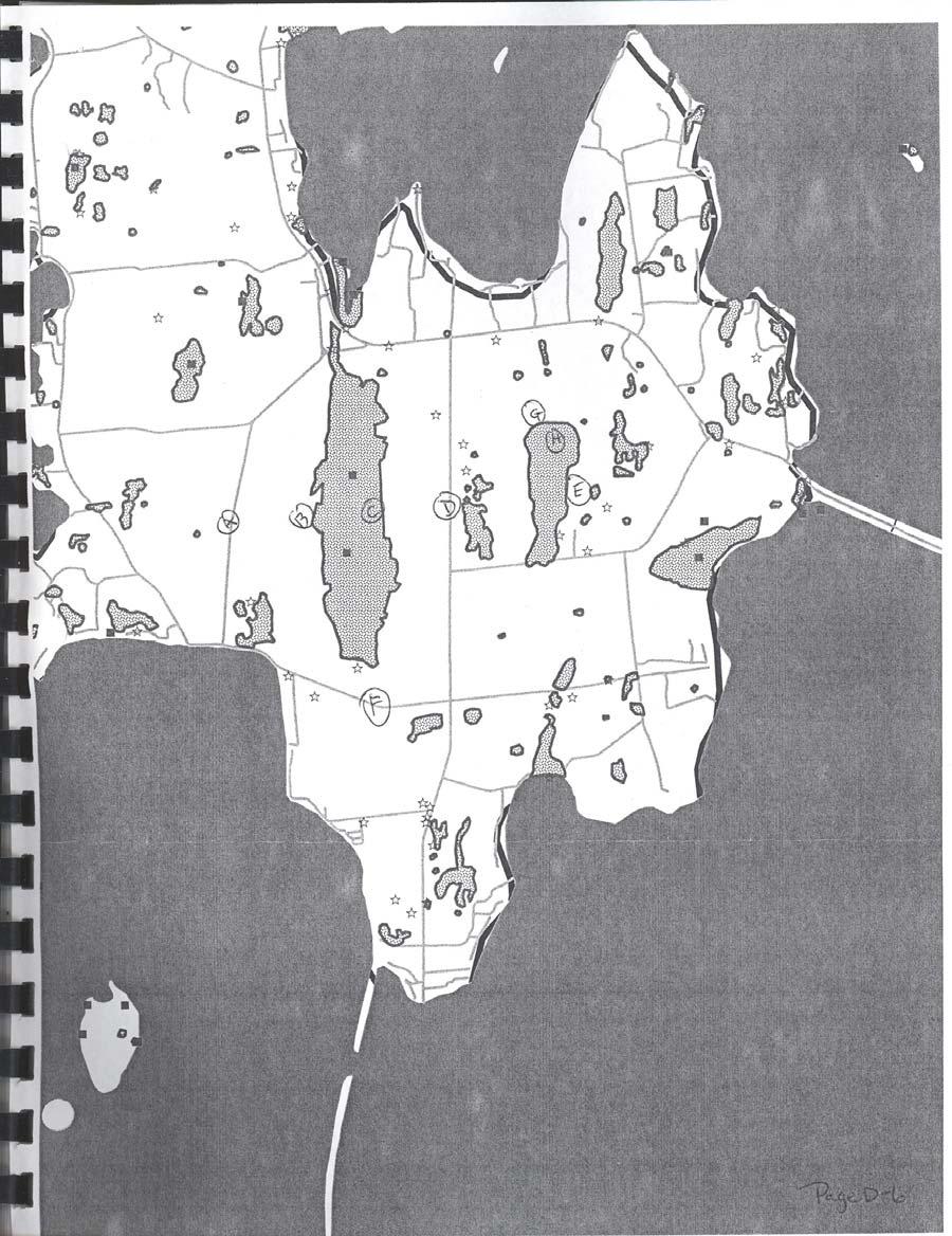
66
67
68
69
70
71
72
73
74
75
76
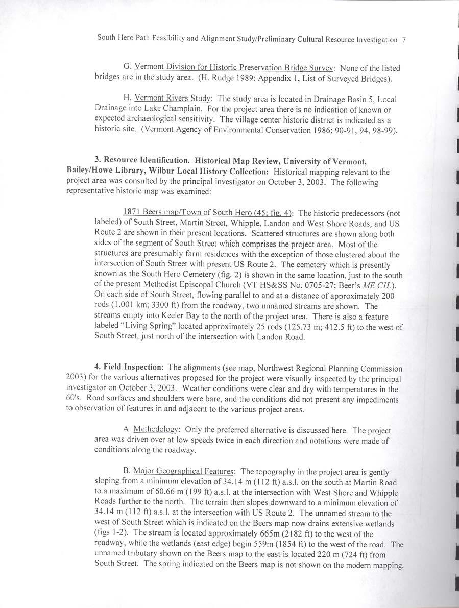
77
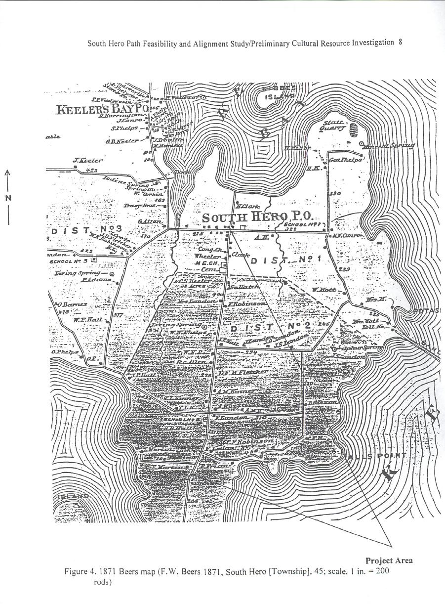
78
79
80
81
82
83
84
85
86
87
88
89
90
91
92
93
94
95
96
97
98
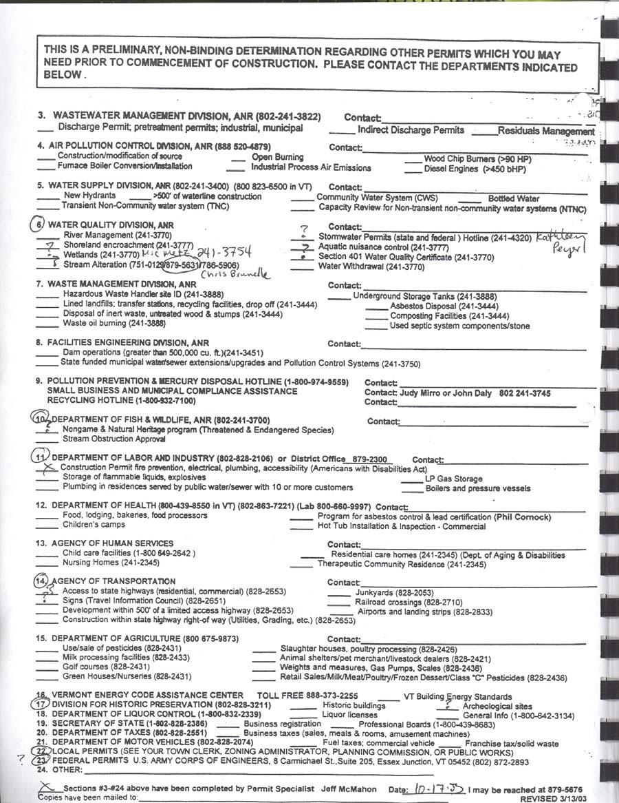
99
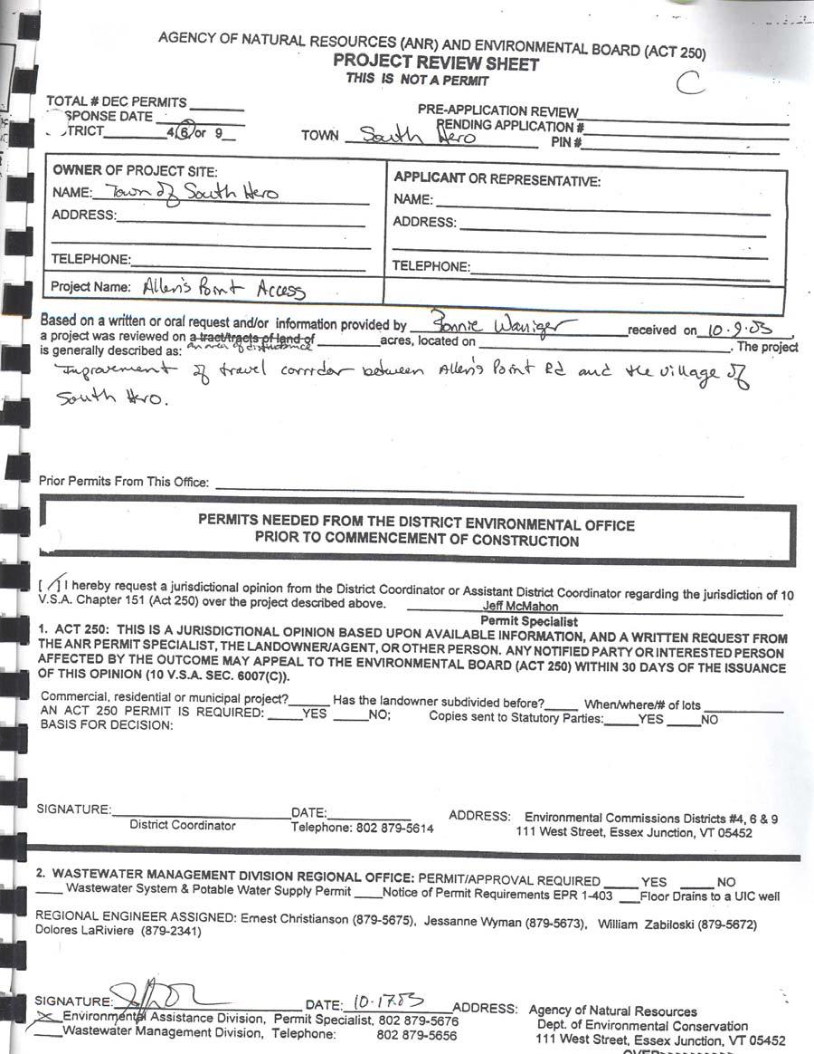
100
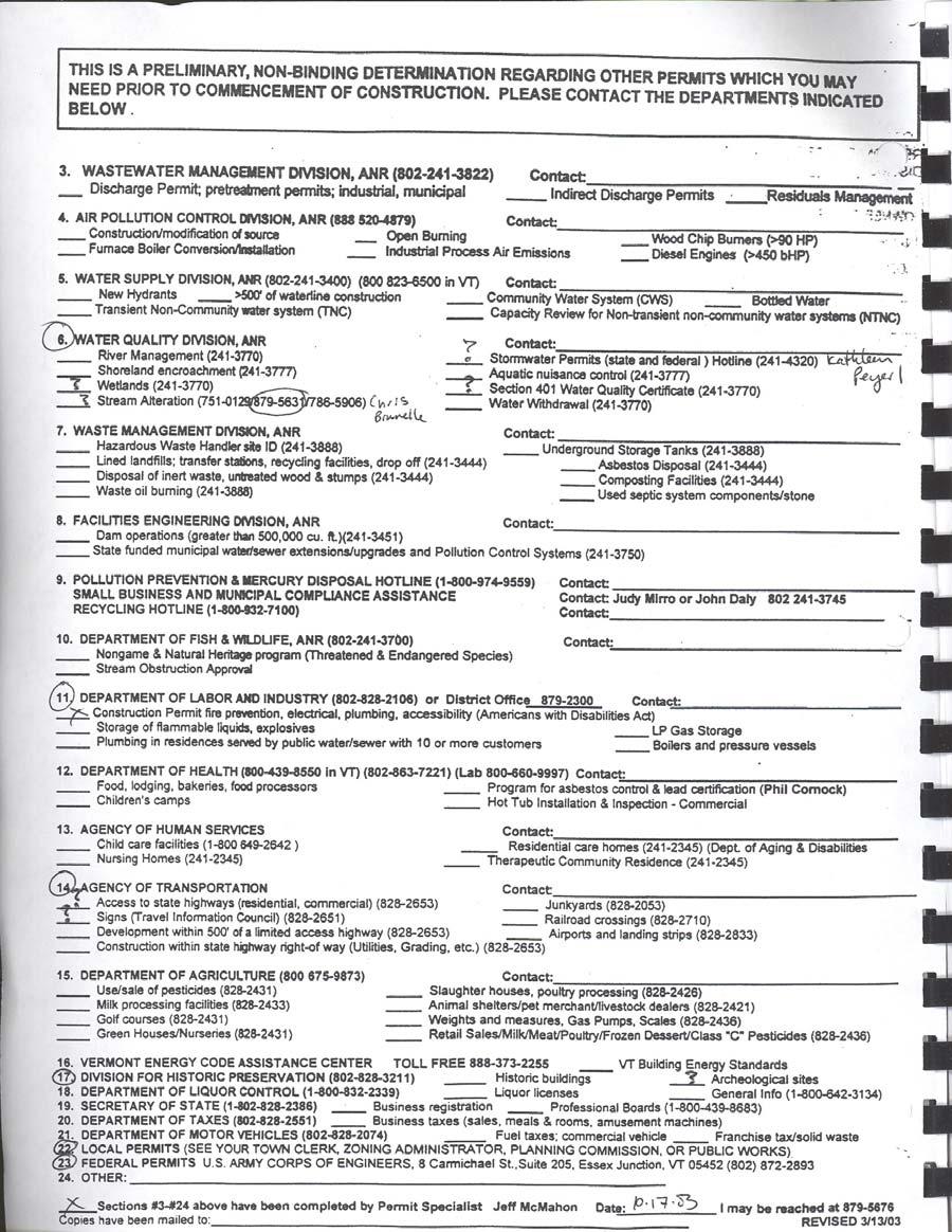
101
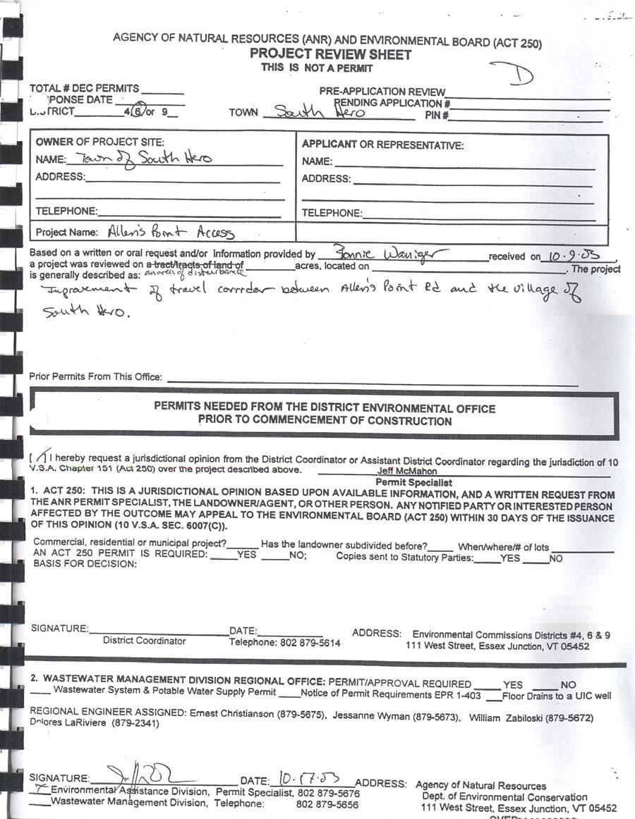
102
103
104

105
106
107
108
109
110
111
112 ATTACHMENT E Study Steering Committee Membership COMMITTEE MEMBER Sarah Jacoby Warren Steadman Coletta Greenbaum Phil Reynolds/Jim Mogan Rose Wright Rob Straight Kathleen Swanson Ethelyn Dubuque John Golden/Ruth Wallman Bill Crenshaw Chapin Spencer/Brian Costello Don Smallwood Amy Bell ORGANIZATION OR INTEREST REPRESENTED Town of South Hero Selectboard Town of South Hero Selectboard Town of South Hero Recreation Committee South Hero Recreation Committee Equestrian Community Island Snowrunners Local Business Owner Local Land Owner Champlain Islands Chamber of Commerce VT Department of Fish and Wildlife Local Motion Town of South Hero (Administrative Assistance) Vermont Agency of Transportation Page D-2
113 Wallys Point Rd Grand Isle Ferry Ed Weed Fish Hatchery Rockwell Bay West Shore Rd Ferry Rd 314 Eagle Camp Rd 2 Lombard Ln Town Line Rd Keeler Bay Access Area Keeler Bay Sweeney Rd Kellog Island Hoyt Bay Hoyt Point Kibbe Farm Rd Lake Champlain Kibbe Point Fish Bladder Island Meadow Ln Keeler Bay Keeler Bay Rd Cedar Island Sawyer Island Sawyer Bay Sunset View Rd Tracy Rd Hill Rd Carte r Ln Heritage Dr Gifford Ln Kibbe Point Rd Richards Rd Paradise Bay Barnes Bay McBride Bay Jackson Point Beech Bay Jackson Pt Narrows Rd Phelps Point The Narrows West Shore Rd Colodny Way Cresent Bay Farm Cresent Bay Rd Station Rd Snowfarm Vineyard Lake View Rd South Hero Town Beach South Hero Marsh Trail South Hero Bicentennial Museum South Hero Marsh Wildlife Management Area (Important boundary Hackett's information in legend) Orchard Farmstand Allenholm Airport South St Folsom Elementary School Allenholm Farm Farmstand Landon Rd Whipple Rd East Shore Rd John Stark Rd 2 Round Pond State Park Contentment Ln Good Hope Horse Farm Featherbed Ln Apple Island Camp Ground VAST Clubhouse To Causeway Overlook Sand Bar Bridge East Shore Rd Providence Island Martin Rd South St Allen Point Access Area Hochelaga Rd Robinson Point Carleton's Prize Camp Hochelega Stave Island Seaplace Stave Island Camp Skyland Allen Point Miles ,000 2,000 Meters 0 2,000 4,000 8,000 Feet Area of Study South Hero Marsh Trail Electric Transmission Line Town Boundary Federal Highway State Highway Road Surface Type Surfaced Gravel Soil or Graded and Drained Earth Impassable or Untravelled Unknown Surface Type Figure: 1 Town of South Hero Study Area Church Cemetery Fishing Access Boat Access Ferry Dock Municipal Property Public Conserved Land South Hero Marsh Wildlife Management Area (SH Marsh WMA boundary is known to be incorrect; a corrected boundary is not available from the State of Vermont Fish & Wildlife Department.) Prepared By: Northwest Regional Planning Commission 7 Lake Street, Suite 201 St. Albans, VT (802) Engineers Planners Economists & Wilber Smith and Associates 4076 Shelburne Road Shelburne, VT (802) For Planning Purposes Only June, 2004 Vermont Coordinate System Transverse Mercator, NAD 83
114
115
116
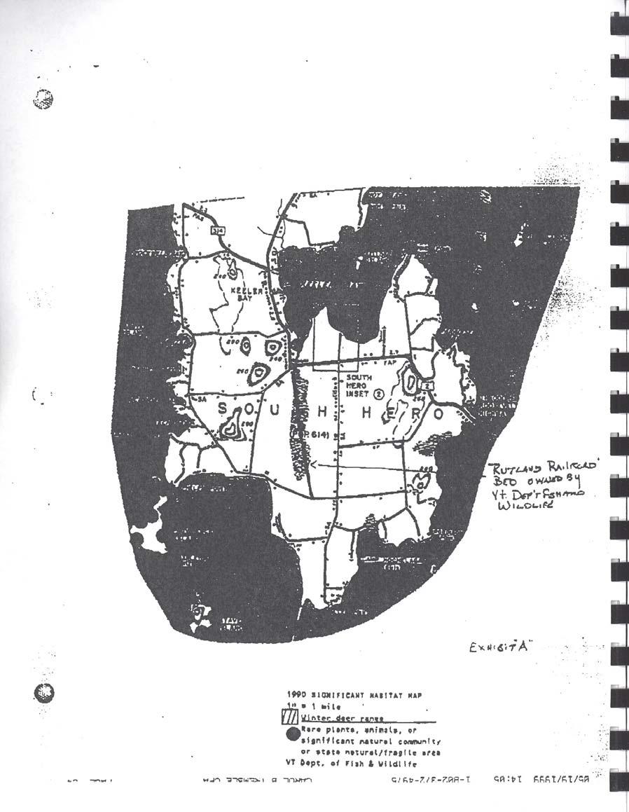
117
118
119
120
121
122
123
124

 Landon Rd 2 Sand Bar Bridge Narrows Rd Phelps Point The Narrows Colodny Way Cresent Bay Rd South St Whipple Rd East Shore Rd Round Pond State Park Contentment Ln East Shore Rd")

125 Wallys Point Rd Featherbed Ln Town Line Rd Sweeney Rd Hoyt Bay Hoyt Point Ferry Rd Lombard Ln Rockwell Bay West Shore Rd 314 Eagle Camp Rd 2 Keeler Bay Access Area Keeler Bay Kellog Island Kibbe Farm Rd Kibbe Point Fish Bladder Island Meadow Ln Keeler Bay Rd Cedar Island Sawyer Island Sawyer Bay Sunset View Rd Tracy Rd Hill Rd Carte r Ln Heritage Dr Gifford Ln Kibbe Point Rd Richards Rd Paradise Bay Barnes Bay John Stark Rd McBride Bay Jackson Point Beech Bay West Shore Rd Jackson Pt Station Rd Lake View Rd South Hero Marsh Trail South Hero Marsh Wildlife Management Area (Important boundary information in legend) Landon Rd 2 Sand Bar Bridge Narrows Rd Phelps Point The Narrows Colodny Way Cresent Bay Rd South St Whipple Rd East Shore Rd Round Pond State Park Contentment Ln East Shore Rd Providence Island Martin Rd South St Hochelaga Rd Robinson Point Carleton's Prize (Public Conserved Land) Allen Point Access Area Stave Island Colchester Causway Trail Allen Point Miles ,000 2,000 Meters 0 2,000 4,000 8,000 Feet Threatened and Endangered Species Ditches Church Powerlines Cemetery Woodsy Areas Fishing Access Large Trees Lining Road Storm Drains Water Lines Listed on the Vermont Active Hazardous Sites List Stream South Hero Marsh Trail Electric Transmission Line Town Boundary Boat Access Parcel Boundary Federal Highway State Highway Road Surface Type Surfaced Gravel Soil or Graded and Drained Earth Impassable or Untravelled Unknown Surface Type Figure: 2 Town of South Hero Existing Conditions Wetlands Soils of State- Wide Agricultural Importance Frequently Flooded Soils Soils with Slopes Greater than 25% Municipal Property Public Conserved Land South Hero Marsh Wildlife Management Area (SH Marsh WMA boundary is known to be incorrect; a corrected boundary is not available from the State of Vermont Fish & Wildlife Department.) Prepared By: Northwest Regional Planning Commission 7 Lake Street, Suite 201 St. Albans, VT (802) Engineers Planners Economists & Wilber Smith and Associates 4076 Shelburne Road Shelburne, VT (802) For Planning Purposes Only June, 2004 Vermont Coordinate System Transverse Mercator, NAD 83
126 Kibbe Point Rd Wallys Point Rd Rd Heritage Dr Carter Ln Tracy Rd Hill Rd South Hero Bicentennial Museum John Stark Rd Cresent Bay Farm ent Bay Rd Station Rd Snowfarm Vineyard Lake View Rd A (State Owned Land) South Hero Marsh Trail South Hero Marsh Wildlife Management Area (Important boundary information in legend) C Hackett's Orchard Farmstand Allenholm Airport G H Folsom Elementary School DAllenholm Farm Farmstand South St Landon Rd E East Shore Rd South Hero Town Beach B F Whipple Rd East Shore Rd Hochelaga Rd Martin Rd South St Miles ,000 2,000 3,000 Feet ,000 Meters Alternative Routes Path A- Lake View Road Path B- South Hero Marsh Trail Path C- Orchards Path D- South Street Path E- East Side Path F- West Shore Road Path G- Power Line Path H- School Access Route on Public Property Route on Private Property Route Contraints Conflict Points Physical Contraints Environmental Concerns Cemetery Fishing AccessAllen Point Boat Access Access Area Federal Highway Road Surface Type Surfaced Gravel Soil or Graded and Drained Earth Impassable or Untravelled Unknown Surface Type Figure: 3 Town of South Hero Alternative Routes Camp Hochelega South Hero Marsh Trail Electric Transmission Line Parcels Municipal Property Public Conserved Land South Hero Marsh Wildlife Management Area (SH Marsh WMA boundary Camp is known to be incorrect; a corrected Skyland boundary is not available from the State of Vermont Fish & Wildlife Department.) Prepared By: Northwest Regional Planning Commission 7 Lake Street, Suite 201 St. Albans, VT (802) Engineers Planners Economists & Wilber Smith and Associates 4076 Shelburne Road Shelburne, VT (802) For Planning Purposes Only June, 2004 Vermont Coordinate System Transverse Mercator, NAD 83
127 bbe Point Rd Wallys Point Rd d Heritage Dr Carter Ln Tracy Rd Hill Rd South Hero Bicentennial Museum John Stark Rd resent y Farm t Bay Rd Station Rd Snowfarm Vineyard Lake View Rd (State Owned Land) South Hero Marsh Trail South Hero Marsh Wildlife Management Area (Important boundary information in legend) Hackett's Orchard Farmstand Clear to 8 ft Wide and Level Allenholm Airport South St Folsom Elementary School D Allenholm Farm Farmstand Add 2-3 ft Shoulder Landon Rd Add 2-3 ft Shoulder East Shore Rd South Hero Town Beach No Change Hochelaga Rd Whipple Rd Lower roadway by 5 ft over hill; Consider adding "STOP" sign at intersection. East Shore Rd Miles ,000 2,000 3,000 Feet ,000 Meters Martin Rd South St Conflict Points Path D- South Street Preferred Route Fishing Access Boat Access Cemetery Federal Highway Road Surface Type Surfaced Gravel Soil or Graded and Drained Earth Impassable or Untravelled Unknown Surface Type Town of South Hero Preferred Alternative South Allen Hero Point Marsh Trail Electric Access Transmission Area Line Parcels Municipal Property Public Conserved Land South Hero Marsh Wildlife Management Area Figure: 4 (SH Marsh WMA boundary is known to be incorrect; a corrected boundary is not available from the State of Vermont Fish & Wildlife Department.) Camp Skyland Camp Hochelega Prepared By: Northwest Regional Planning Commission 7 Lake Street, Suite 201 St. Albans, VT (802) Engineers Planners Economists & Wilber Smith and Associates 4076 Shelburne Road Shelburne, VT (802) For Planning Purposes Only June, 2004 Vermont Coordinate System Transverse Mercator, NAD 83

 Orchard Farmstand Allenholm")

128 Grand Isle Ferry Ed Weed Fish Hatchery Rockwell Bay West Shore Rd Ferry Rd 314 Eagle Camp Rd 2 Lombard Ln Town Line Rd Keeler Bay Access Area Keeler Bay Sweeney Rd Kellog Island Hoyt Bay Hoyt Point Kibbe Farm Rd Kibbe Point Lake Champlain Fish Bladder Island Meadow Ln Keeler Bay Keeler Bay Rd Cedar Island Sawyer Island Barnes Bay Sawyer Bay McBride Bay Jackson Point Beech Bay Jackson Pt Narrows Rd Phelps Point The Narrows West Shore Rd Colodny Way Cresent Bay Farm Sunset View Rd Cresent Bay Rd Station Rd Snowfarm Vineyard Lake View Rd South Hero Town Beach Beach Tracy Rd South Hero Marsh Trail Rail Trail Wallys Point Rd Hill Rd South Hero Bicentennial Museum South Hero Marsh Wildlife Management Area (Important boundary Hackett's information in legend) Orchard Farmstand Allenholm Airport South St Carte r Ln Heritage Dr Folsom Elementary School Allenholm Farm Farmstand Landon Rd Whipple Rd Gifford Ln Village School East Shore Rd Kibbe Point Rd John Stark Rd East Shore Rd Richards Rd 2 Round Pond State Park Contentment Ln Good Hope Horse Farm Paradise Bay Featherbed Ln Apple Island Camp Ground VAST Clubhouse To Causeway Overlook Sand Bar Bridge Providence Island Martin Rd South St Allen Point Access Area Hochelaga Rd Robinson Point Carleton's Prize Camp Hochelega Stave Island Seaplace Stave Island Access Area Camp Skyland Allen Point Miles ,000 2,000 Meters 0 2,000 4,000 8,000 Feet Origins and Destinations for Pedestrians and Cyclists Bicycle and Pedestrian Use Low Level of Use Medium Level of Use High Level of Use South Hero Marsh Trail Electric Transmission Line Town Boundary Figure: B-1 Town of South Hero Resident Bicycle and Pedestrian Origins, Destinations and Levels of Use Church Cemetery Federal Highway State Highway Road Surface Type Surfaced Gravel Soil or Graded and Drained Earth Impassable or Untravelled Unknown Surface Type Fishing Access Boat Access Ferry Dock Municipal Property Public Conserved Land South Hero Marsh Wildlife Management Area (SH Marsh WMA boundary is known to be incorrect; a corrected boundary is not available from the State of Vermont Fish & Wildlife Department.) Prepared By: Northwest Regional Planning Commission 7 Lake Street, Suite 201 St. Albans, VT (802) Engineers Planners Economists & Wilber Smith and Associates 4076 Shelburne Road Shelburne, VT (802) For Planning Purposes Only June, 2004 Vermont Coordinate System Transverse Mercator, NAD 83


129 Ed Weed Fish Hatchery Grand Isle Ferry Ferry & Restaurant Rockwell Bay Eagle Camp & View West Shore Rd Ferry Rd 314 Eagle Camp Rd 2 Lombard Ln Town Line Rd Keeler Bay Access Area Keeler Bay Sweeney Rd Kellog Island Hoyt Bay Hoyt Point Kibbe Farm Rd Lake Champlain Kibbe Point Fish Bladder Island Meadow Ln Keeler Bay Keeler Bay Rd Cedar Island Sawyer Island Providence Island Barnes Bay Sawyer Bay McBride Bay Jackson Point Beech Bay Jackson Pt Narrows Rd Phelps Point The Narrows View West Shore Rd Colodny Way Carleton's Prize View Cresent Bay Farm Sunset View Rd Cresent Bay Rd Station Rd Snowfarm Vineyard Lake View Rd Vineyard South Hero Town Beach Beach Allen Point Access Area Tracy Rd South Hero Marsh Trail Rail Trail Parking Area Wallys Point Rd Martin Rd South St Hill Rd South Hero Bicentennial Museum South Hero Marsh Wildlife Management Area (Important boundary Hackett's information in legend) Orchard Farmstand Orchard Allenholm Airport South St Carte r Ln Hochelaga Rd Camp Hochelega Heritage Dr Folsom Elementary School Allenholm Farm Farmstand Landon Rd Whipple Rd Gifford Ln Village East Shore Rd Kibbe Point Rd John Stark Rd Orchard East Shore Rd Richards Rd 2 Round Pond State Park Contentment Ln Good Hope Horse Farm Paradise Bay Featherbed Ln Apple Island Camp Ground Robinson Point VAST Clubhouse To Causeway Overlook Sand Bar Bridge Stave Island Seaplace Stave Island Access Area Camp Skyland Allen Point Miles ,000 2,000 Meters 0 2,000 4,000 8,000 Feet Origins and Destinations for Pedestrians and Cyclists Bicycle and Pedestrian Use Low Level of Use Medium Level of Use High Level of Use South Hero Marsh Trail Electric Transmission Line Town Boundary Figure: B-2 Town of South Hero Visitor Bicycle and Pedestrian Origins, Destinations and Levels of Use Church Cemetery Federal Highway State Highway Road Surface Type Surfaced Gravel Soil or Graded and Drained Earth Impassable or Untravelled Unknown Surface Type Fishing Access Boat Access Ferry Dock Municipal Property Public Conserved Land South Hero Marsh Wildlife Management Area (SH Marsh WMA boundary is known to be incorrect; a corrected boundary is not available from the State of Vermont Fish & Wildlife Department.) Prepared By: Northwest Regional Planning Commission 7 Lake Street, Suite 201 St. Albans, VT (802) Engineers Planners Economists & Wilber Smith and Associates 4076 Shelburne Road Shelburne, VT (802) For Planning Purposes Only June, 2004 Vermont Coordinate System Transverse Mercator, NAD 83


130 Grand Isle Ferry Rockwell Bay View and Water Access West Shore Rd Ed Weed Fish Hatchery Ferry Rd Eagle Camp Rd Meadow Ln 314 Neighborhood Trail Network 2 Keeler Bay Lombard Ln Access Area Keeler Bay Rd Town Line Rd Keeler Bay Access Area Keeler Bay Neighborhood Trail Network Horse Boarding Sweeney Rd Kellog Island Hoyt Bay Hoyt Point Lake Champlain Kibbe Point Kibbe Farm Rd Fish Bladder Island Cedar Island Sawyer Island Barnes Bay Sawyer Bay McBride Bay Jackson Point Beech Bay Phelps Point The Narrows Jackson Pt Narrows Rd View West Shore Rd Colodny Way Cresent Bay Farm Sunset View Rd Cresent Bay Rd Tracy's Woods Trail Network Station Rd Snowfarm Vineyard Lake View Rd View South Hero Town Beach Tracy Rd South Hero Marsh Trail South Hero Bicentennial Museum South Hero Marsh Wildlife Management Area Hill Rd (Important boundary Hackett's information in legend) Orchard Farmstand Wallys Point Rd Allenholm Airport South St Carte r Ln Heritage Dr Village Services Folsom Elementary School Allenholm Farm Farmstand Landon Rd Whipple Rd Gifford Ln Stables East Shore Rd Kibbe Point Rd John Stark Rd Richards Rd 2 Round Pond State Park Contentment Ln Good Hope Horse Farm Paradise Bay Stables Featherbed Ln Apple Island Camp Ground VAST Clubhouse VAST Clubhouse To Causeway Overlook Sand Bar Bridge East Shore Rd Providence Island Martin Rd South St Hochelaga Rd Knee Deep Road Water Access Robinson Point Carleton's Prize Allen Point Access Area Camp Hochelega Stave Island Seaplace Stave Island Access Area Camp Skyland Allen Point Miles ,000 2,000 Meters 0 2,000 4,000 8,000 Feet Snowmobile Routes Origins/Destinations Existing Route Proposed Route Equestrian Routes* Origins/Destinations CHAMP Route Other Routes *Note: Equestrian Routes are informal agreements with landowners only. South Hero Marsh Trail Electric Transmission Line Town Boundary Figure: B-3 Town of South Hero Equestrian and Snowmobile Routes Church Fishing Access Cemetery Boat Access Federal Highway Ferry Dock State Highway Road Surface Type Municipal Property Surfaced Public Conserved Land Gravel South Hero Marsh Soil or Graded and Drained Earth Wildlife Management Area Impassable or Untravelled (SH Marsh WMA boundary is known to be incorrect; a corrected boundary is not available Unknown Surface Type from the State of Vermont Fish & Wildlife Department.) Prepared By: Northwest Regional Planning Commission 7 Lake Street, Suite 201 St. Albans, VT (802) Engineers Planners Economists & Wilber Smith and Associates 4076 Shelburne Road Shelburne, VT (802) For Planning Purposes Only June, 2004 Vermont Coordinate System Transverse Mercator, NAD 83
 Orchard Farmstand Allenholm Airport South St Folsom Elementary School Allenholm Farm Farmstand")


 Figure: B-4 Town of South Hero Roadway Characteristics Electric Transmission Line Town Boundary South Hero Marsh Trail Federal Highway State Highway Road Surface Type Surfaced Gravel Soil or Graded")
131 d Tracy Rd Hill Rd Carte r Ln ritage Dr rd Ln Rd Richards Rd Bay tation Rd Snowfarm Vineyard y Rd Lake View Rd South Hero Town Beach South Hero Marsh Trail(State Owned Land) South Hero Bicentennial Museum South Hero Marsh Wildlife Management Area (Important boundary Hackett's information in legend) Orchard Farmstand Allenholm Airport South St Folsom Elementary School Allenholm Farm Farmstand Landon Rd Whipple Rd East Shore Rd John Stark Rd 2 Round Pond State Park Contentment Ln Good Hope Horse Farm Featherbed Ln Apple Island Camp Ground VAST Clubhouse East Shore Rd Martin Rd South St Hochelaga Rd Robinson Point Allen Point Access Area Camp Hochelega Camp Skyland Allen Point 0 1,000 2,000 4,000 Feet ,000 1,500 Meters Miles Path/Access Widths 5 Feet 9.5 Feet Lane Widths 9 Feet 10 Feet 10.5 Feet 11 Feet 11.5 Feet Church Cemetery Fishing Access Boat Access Ferry Dock Municipal Property Public Conserved Land South Hero Marsh Wildlife Management Area (SH Marsh WMA boundary is known to be incorrect; a corrected boundary is not available from the State of Vermont Fish & Wildlife Department.) Figure: B-4 Town of South Hero Roadway Characteristics Electric Transmission Line Town Boundary South Hero Marsh Trail Federal Highway State Highway Road Surface Type Surfaced Gravel Soil or Graded and Drained Earth Impassable or Untravelled Unknown Surface Type Prepared By: Northwest Regional Planning Commission 7 Lake Street, Suite 201 St. Albans, VT (802) Engineers Planners Economists & Wilber Smith and Associates 4076 Shelburne Road Shelburne, VT (802) For Planning Purposes Only June, 2004 Vermont Coordinate System Transverse Mercator, NAD 83
AGENDA ITEM 5 D WAKULLA ENVIRONMENTAL INSTITUTE (WEI) TRAIL FEASIBILITY STUDY
 TRAIL FEASIBILITY STUDY") March 19, 2018 AGENDA ITEM 5 D WAKULLA ENVIRONMENTAL INSTITUTE (WEI) TRAIL FEASIBILITY STUDY TYPE OF ITEM: Action STATEMENT OF ISSUE The Wakulla Environmental Institute (WEI) Trail is one of several trails
March 19, 2018 AGENDA ITEM 5 D WAKULLA ENVIRONMENTAL INSTITUTE (WEI) TRAIL FEASIBILITY STUDY TYPE OF ITEM: Action STATEMENT OF ISSUE The Wakulla Environmental Institute (WEI) Trail is one of several trails
Longmont to Boulder Regional Trail Jay Road Connection DRAFT FINAL REPORT
 Longmont to Boulder Regional Trail Jay Road Connection DRAFT FINAL REPORT December 2018 Project Summary Boulder County, Colorado, in partnership with the City of Boulder, is evaluating options for multi-use
Rule Governing the Designation and Establishment of All-Terrain Vehicle Use Trails on State Land
 Rule Governing the Designation and Establishment of All-Terrain Vehicle Use Trails on State Land 1.0 Authority 1.1 This rule is promulgated pursuant to 23 V.S.A. 3506. Section 3506 (b)(4) states that an
Public Notice ISSUED: December 10, 2018 EXPIRES: January 9, 2019
 APPLICANT: REFER TO: St. Louis and Lake Counties Regional Rail Authority 2018-01942-ARC Public Notice ISSUED: December 10, 2018 EXPIRES: January 9, 2019 SECTION:404 - Clean Water Act 1. APPLICATION FOR
FEASIBILITY CRITERIA
 This chapter describes the methodology and criteria used to evaluate the feasibility of developing trails throughout the study areas. Land availability, habitat sensitivity, roadway crossings and on-street
Rural Rustic Road Program
 Virginia Department of Transportation s Rural Rustic Road Program Prepared by the Local Assistance Division Virginia Department of Transportation 1401 East Broad Street Richmond, Virginia 23219 Michael
METROPOLITAN COUNCIL 390 North Robert Street, St. Paul, MN Phone (651) TDD (651)
 TDD (651)") METROPOLITAN COUNCIL 390 North Robert Street, St. Paul, MN 55101 Phone (651) 602 1000 TDD (651) 291 0904 DATE: June 19, 2007 TO: Metropolitan Parks and Open Space Commission FROM: Jan Youngquist, Senior
METROPOLITAN COUNCIL 390 North Robert Street, St. Paul, MN 55101 Phone (651) 602 1000 TDD (651) 291 0904 DATE: June 19, 2007 TO: Metropolitan Parks and Open Space Commission FROM: Jan Youngquist, Senior
Auburn Trail / Ontario Pathways Trail Connector Feasibility Study Public Information Meeting Wednesday, August 22, 2012
 Auburn Trail / Ontario Pathways Trail Connector Feasibility Study Public Information Meeting Wednesday, August 22, 2012 Purpose of Feasibility Study Purpose Evaluate the feasibility of constructing a multiuse
A. CONCLUSIONS OF THE FGEIS
 Chapter 11: Traffic and Parking A. CONCLUSIONS OF THE FGEIS The FGEIS found that the Approved Plan will generate a substantial volume of vehicular and pedestrian activity, including an estimated 1,300
PURPOSE AND NEED (CONCURRENCE POINT 1) NEW CANADA ROAD PROJECT FROM STATE ROUTE 1 (U.S. HIGHWAY 70) TO U.S. INTERSTATE 40
 NEW CANADA ROAD PROJECT FROM STATE ROUTE 1 (U.S. HIGHWAY 70) TO U.S. INTERSTATE 40") PURPOSE AND NEED (CONCURRENCE POINT 1) NEW CANADA ROAD PROJECT FROM STATE ROUTE 1 (U.S. HIGHWAY 70) TO U.S. INTERSTATE 40 Project Description The primary purpose of this project is to improve the major
PURPOSE AND NEED (CONCURRENCE POINT 1) NEW CANADA ROAD PROJECT FROM STATE ROUTE 1 (U.S. HIGHWAY 70) TO U.S. INTERSTATE 40 Project Description The primary purpose of this project is to improve the major
Appendix 3. Greenway Design Standards. The Whitemarsh Township Greenway Plan
 Appendix 3 Greenway Design Standards This chapter discusses two design standards for the greenway types discussed above. First, trail design standards are presented together with trailhead facilities and
Georgetown-Lewes Rail/Trail Study. Rail/Trail Study: Cool Spring to Cape Henlopen State Park New Road Extension (House Resolution No.
 Georgetown-Lewes Rail/Trail Study Rail/Trail Study: Cool Spring to Cape Henlopen State Park New Road Extension (House Resolution No. 47) August 22, 2011 Presentation Outline Background Benefits Statewide
4. Safety Concerns Potential Short and Medium-Term Improvements
 NH Route 104 Access Management Study Page 19 4. Safety Concerns Potential Short and Medium-Term Improvements Potential safety improvement strategies are listed by priority based on field observations by
Becker County Trail Routing Feasibility Study
 2016 Becker County Trail Routing Feasibility Study CONNECTING DETROIT MOUNTAIN AND MOUNTAIN VIEW RECREATIONAL AREA TO THE HEARTLAND TRAIL BECKER COUNTY ULTEIG ENGINEERS Contents Acknowledgements...2 INTRODUCTION...3
The Baker/Carver Regional Trail is intended to
 Section V Design Guidance The Baker/Carver Regional Trail is intended to safely accommodate 183,000 annual visits, an array of non-motorized uses, a variety of skill levels, and persons with special needs.
Understanding user expectations And planning for long term sustainability 1
 Understanding user expectations And planning for long term sustainability 1 What is a natural surface trail? It can be as simple has a mineral soil, mulched or graveled pathway, or as developed as elevated
Chapter 4.0 Alternatives Analysis
 Chapter 4.0 Alternatives Analysis Chapter 1 accumulated the baseline of existing airport data, Chapter 2 presented the outlook for the future in terms of operational activity, Chapter 3 defined the facilities
City of Durango 5.8 FUNDING TRAILS DEVELOPMENT
 5.8 FUNDING TRAILS DEVELOPMENT The City has been successful in establishing dedicated local funding sources as well as applying for grants to develop the City s trail system, having received nearly $2.4
2016 Regional Transportation Alternatives Program (TAP) Grant Application
 Grant Application") 2016 Regional Transportation Alternatives Program (TAP) Grant Application PROJECT TITLE: Yelm-Tenino Trail Extension Feasibility Study TRPC use only GENERAL PROJECT INFORMATION Agency or Organization City
2016 Regional Transportation Alternatives Program (TAP) Grant Application PROJECT TITLE: Yelm-Tenino Trail Extension Feasibility Study TRPC use only GENERAL PROJECT INFORMATION Agency or Organization City
Blueways: Rivers, lakes, or streams with public access for recreation that includes fishing, nature observation, and opportunities for boating.
 Parks, Open Space and Trails PRINCE WILLIAM COUNTY 2008 COMPREHENSIVE PLAN TRAILS PLAN CONTENTS The components of the trails plan are: Intent Definitions Goals, Policies, and Action Strategies Trails Map
2. Goals and Policies. The following are the adopted Parks and Trails Goals for Stillwater Township:
 D. PARKS AND TRAILS 1. Introduction Stillwater Township s population is relatively low, with most residents living on rural residences on large lots. The need for active park space has been minimal in
MORGAN CREEK GREENWAY Final Report APPENDICES
 APPENDICES MORGAN CREEK GREENWAY Appendix A Photos of Existing Conditions in Trail Corridor Photos of existing conditions Main trail corridor - February 2009 Photos of existing conditions south bank Morgan
Daisy Dean Trail 628/619 ATV Trail Construction
 Background and Purpose and Need The Daisy Dean ATV Trail Construction Project is located in the Little Belt Mountains, Musselshell Ranger District, Lewis and Clark National Forest approximately 32 miles
Lake Erie Commerce Center Traffic Analysis
 LOCATION: East of NYS Route 5 at Bayview Road Town of Hamburg Erie County, New York PREPARED BY: Wendel Companies 140 John James Audubon Parkway Suite 200 Amherst, New York 14228 January 2012 i ii Table
SUMMER VILLAGE OF SILVER SANDS. Municipal Development Plan
 SUMMER VILLAGE OF SILVER SANDS Municipal Development Plan Bylaw 253-2014 Adopted August 22, 2014 Summer Village of Silver Sands Municipal Development Plan Bylaw No. 253-2014 Page 2 1 INTRODUCTION 1.1 SETTING
Continental Divide National Scenic Trail Legislative History and Planning Guidance
 Continental Divide National Scenic Trail Legislative History and Planning Guidance Legislation, Policy, and Direction Regarding National Scenic Trails The National Trails System Act, P.L. 90-543, was passed
Sawtooth National Forest Fairfield Ranger District
 United States Department of Agriculture Forest Service Sawtooth National Forest Fairfield Ranger District P.O. Box 189 Fairfield, ID. 83327 208-764-3202 Fax: 208-764-3211 File Code: 1950/7700 Date: December
Trail Feasibility Study
 VOLUSIA COUNTY MPO CITY OF NEW SMYRNA BEACH FINAL REPORT JUNE 30, 2009 Trail Feasibility Study What s inside? 1 Introduction 2 Project Purpose & Scope 3 Physical Inventory & Assessment of Right-of- Way
Blue River Trail Master Plan JSA to Town Hall June 2004
 Blue River Trail Master Plan JSA to Town Hall June 2004 Prepared for: Silverthorne Town Council Silverthorne SPORT Committee Department of Recreation and Culture Silverthorne Public Works Silverthorne
Citrus Heights Creek Corridor Trail Project Trail Advisory Group Field Trip #2 September 11, :00 11:00 am Trellis Hall, Citrus Heights
 September 11, 2013 9:00 11:00 am Trellis Hall, Citrus Heights Project Overview The City of Citrus Heights is studying the feasibility of establishing a multi use trail system within the City s 26 miles
Bradley Brook Relocation Project. Scoping Notice. Saco Ranger District. United States Department of Agriculture Forest Service
 Bradley Brook Relocation Project United States Department of Agriculture Forest Service Scoping Notice White Mountain National Forest February 2011 For Information Contact: Jenny Burnett White Mountain
MUNICIPALITY OF ANCHORAGE
 MUNICIPALITY OF ANCHORAGE ANCHORAGE PARKS & RECREATION Memorandum PRC 08-56 DATE: 5 August 2008 TO: FROM: SUBJECT: Parks & Recreation Commission Holly Spoth-Torres, Park Planner PRC 08-56 Far North Bicentennial
DRAFT - APRIL 13, 2007 ROUTING STUDY FOR TRAIL CONNECTIONS BETWEEN CALAIS AND AYERS JUNCTION
 DRAFT - APRIL 13, 2007 ROUTING STUDY FOR TRAIL CONNECTIONS BETWEEN CALAIS AND AYERS JUNCTION Abstract The vision for the East Coast Greenway is an off-road urban trail system running from Calais, Maine
4.0 Context for the Crossing Project
 4.0 Context for the Crossing Project This section provides background information about key features of the North Douglas Crossing project area, and opportunities and constraints. This information is important
EAST DON TRAIL ENVIRONMENTAL ASSESSMENT. Community Liaison Committee Meeting #3 July 15, :30 to 8:30 pm Flemingdon Park Library
 EAST DON TRAIL ENVIRONMENTAL ASSESSMENT Community Liaison Committee Meeting #3 July 15, 2013 6:30 to 8:30 pm Flemingdon Park Library Agenda 1. Welcome 2. Housekeeping and Updates a) Housekeeping b) CLC
3. COLTA / HUGA CONNECTIONS - PRELIMINARY
 9 3. COLTA / HUGA CONNECTIONS - PRELIMINARY 3.1 COLTA The Chain of Lakes Trail Association (COLTA) trail, formerly identified as the Chester Spur Line, was completed and opened for use in June 2011. The
Logo Department Name Agency Organization Organization Address Information 5700 North Sabino Canyon Road
 Logo Department Name Agency Organization Organization Address Information United States Forest Coronado National Forest 5700 North Sabino Canyon Road Department of Service Santa Catalina Ranger District
Addendum - Airport Development Alternatives (Chapter 6)
") Bowers Field Addendum - Airport Development Alternatives (Chapter 6) This addendum to the Airport Development Alternatives chapter includes the preferred airside development alternative and the preliminary
Bowers Field Addendum - Airport Development Alternatives (Chapter 6) This addendum to the Airport Development Alternatives chapter includes the preferred airside development alternative and the preliminary
CHAPTER III: TRAIL DESIGN STANDARDS, SPECIFICATIONS & PERMITS
 CHAPTER III Trail Design Standards, Specifications & Permits This chapter discusses trail standards, preferred surface types for different activities, permits, and other requirements one must consider
$866,000. $1,400,000 Health Benefits $13,156,000 TOTAL ANNUAL DIRECT BENEFITS. $10,890,000 Economic Benefits
 SINGING RIVER TRAIL Trails Create Value + Generate Economic Activity Trails generate economic returns through improved health, safety, and environmental conditions, raise property values, and attract visitors.
C. APPROACH FOR IDENTIFYING THE BEST ROUTES FOR THE NEEDED TRANSMISSION SYSTEM IMPROVEMENTS
 C. APPROACH FOR IDENTIFYING THE BEST ROUTES FOR THE NEEDED TRANSMISSION SYSTEM IMPROVEMENTS CL&P s approach for identifying the best routes for the needed transmission system improvements included a determination
3.0 LEARNING FROM CHATHAM-KENT S CITIZENS
 3.0 LEARNING FROM CHATHAM-KENT S CITIZENS An important aspect in developing the Chatham-Kent Trails Master Plan was to obtain input from stakeholders and the general public. Throughout the course of the
DRAFT (30 Nov 2016) MULTI-MODAL GATEWAY PLAN for the Town of Brattleboro
 MULTI-MODAL GATEWAY PLAN for the Town of Brattleboro") MULTI-MODAL GATEWAY PLAN for the Town of Brattleboro 30 November 2016 Prepared for the Windham Regional Commission and the Town of Brattleboro by the consultant team of PlaceSense and VHB. PHOTO CREDITS
MULTI-MODAL GATEWAY PLAN for the Town of Brattleboro 30 November 2016 Prepared for the Windham Regional Commission and the Town of Brattleboro by the consultant team of PlaceSense and VHB. PHOTO CREDITS
PULLMAN-MOSCOW REGIONAL AIRPORT Runway Realignment Project
 PULLMAN-MOSCOW REGIONAL AIRPORT Runway Realignment Project GENERAL AIRPORT INFORMATION AIRPORT USERS Airport ownership: Public, owned by the Pullman-Moscow Regional Airport Board Year opened: February
Virginia Department of Transportation s Rural Rustic Road Program
 Virginia Department of Transportation s Rural Rustic Road Program Prepared by the Local Assistance Division Virginia Department of Transportation 1401 East Broad Street Richmond, Virginia 23219 Michael
Decision Memo Broken Wheel Ranch Equestrian Outfitter Special-Use Permit Proposed Action
 Decision Memo Broken Wheel Ranch Equestrian Outfitter Special-Use Permit USDA Forest Service Mississippi Bluffs Ranger District, Shawnee National Forest Jackson and Union Counties, Illinois Proposed Action
Chapter 6: POLICY AND PROCEDURE RECOMMENDATIONS
 Chapter 6 POLICY AND PROCEDURE RECOMMENDATIONS FOR SRRA Below are seven policy elements that should be considered for adoption by the Southwest Regional Recreation Authority of Virginia: 1. Develop strategies
FHWA P/N Guidelines. Corridor Relationship. Highway 22 Segment 1 - US 169 to CSAH 2 Relevance / Documentation of Need
 Highway 22 Segment 1 - US 169 to CSAH 2 Vehicle Mobility Congestion Intersection Congestion Existing Conditions - Based on Highway Capacity Manual methodology, corridor level of service is currently LOS
Date: 11 th January, From: Plaistow & Ifold Parish Neighbourhood Plan - Steering Group. Plaistow & Ifold Parish Council
 Date: 11 th January, 2017 From: Plaistow & Ifold Parish Neighbourhood Plan - Steering Group To: Plaistow & Ifold Parish Council Re: Neighbourhood Plan Report to Parish Council Meeting 17 Jan 2017 The Steering
FINAL. Bicycle/Pedestrian Feasibility Study City of DeBary Dirksen Drive Trail. Prepared For: Volusia County MPO
 City of DeBary Dirksen Drive Trail FINAL Prepared By: Reynolds, Smith and Hills, Inc. Prepared For: Volusia County MPO September 2007 Table of Contents INTRODUCTION...1 PROJECT PURPOSE AND SCOPE...2 PHYSICAL
Non-Motorized Transportation
 Non-Motorized Transportation Non-motorized facilities are important components to the transportation system. They provide an environmentally-friendly, low-cost mode of travel. Some of the facilities can
Section 3-04 Cross Sectional Elements TABLE OF CONTENTS. INTRODUCTION...3 General...3 Exhibit 1-Cross-Sectional Elements...3
 Section 3-04 Cross Sectional Elements TABLE OF CONTENTS INTRODUCTION...3 General...3 Exhibit 1-Cross-Sectional Elements...3 CROSS-SECTIONAL ELEMENTS...3 Traveled Way...3 Shoulder...3 Surfacing Taper...3
Vista Field Airport. Master Plan Update. February, Prepared for: Port of Kennewick One Clover Island Kennewick, Washington
 Vista Field Airport February, 2006 Prepared for: Port of Kennewick One Clover Island Kennewick, Washington 99336 Prepared by: J-U-B ENGINEERS, Inc. 2810 W. Clearwater Avenue, Suite 201 Kennewick, Washington
Estimating Tourism Expenditures for the Burlington Waterfront Path and the Island Line Trail
 A report by the University of Vermont Transportation Research Center Estimating Tourism Expenditures for the Burlington Waterfront Path and the Island Line Trail Report # 10-003 February 2010 Estimating
Preferred Recreation Recommendations Stemilt-Squilchuck Recreation Plan March 2018
 Preferred Recreation Recommendations Stemilt-Squilchuck Recreation Plan March 2018 Below are the recommended recreation ideas and strategies that package together the various recreation concepts compiled
Preliminary Findings of Proposed Alternative
 Preliminary Findings of Proposed Alternative The attached drawing provides a schematic layout of the proposed alternative that will be discussed on July 27, 2010. A full report will follow and should be
This section evaluates the projected traffic operations and circulation impacts associated with the proposed upgrade and expansion of the LWRP.
 4.5 TRAFFIC AND CIRCULATION This section evaluates the projected traffic operations and circulation impacts associated with the proposed upgrade and expansion of the LWRP. 4.5.1 Environmental Setting Existing
COMMUNITY MEETING NOVEMBER 1, Wheaton Regional Park Pine Lake Trail
 COMMUNITY MEETING NOVEMBER 1, 2012 MEETING AGENDA I. Introduction of Project Team II. Trail Renovation Process III. Wheaton Regional Park IV. Pine Lake Trail Renovation Project V. Comments and Questions
4.19 Parks, Recreation, and Conservation Lands
 interchange would have on the Reed Paige Clark Homestead located on the north side of Stonehenge Road. Alternative D would also affect Palmer Homestead, E.F. Adams House, and Knapp Brothers Shoe Manufacturing
HAMPTON ROADS CROSSINGS PATRIOTS CROSSING AND HRBT
 HRTPO Board Meeting March 21, 2013 Agenda ITEM #9: HAMPTON ROADS CROSSINGS PATRIOTS CROSSING AND HRBT Congestion at the Hampton Roads Bridge-Tunnel (HRBT) on I-64 has long been identified as a problem
MONTGOMERY COUNTY PLANNING DEPARTMENT THE MARYLAND-NATIONAL CAPITAL PARK AND PLANNING COMMISSION
 MONTGOMERY COUNTY PLANNING DEPARTMENT THE MARYLAND-NATIONAL CAPITAL PARK AND PLANNING COMMISSION MCPB Item No. Date: 6/23/2016 Lucy V. Barnsley Elementary School Addition, Mandatory Referral MR2016027
I. INTRODUCTION EAST COAST GREENWAY STUDY PURPOSE
 I. INTRODUCTION STUDY PURPOSE The purpose of this study is to determine the engineering feasibility of developing the Eastern Trail. It was initiated at the request of the and funded by the Maine Department
chapter - Hex Highway Touring Route Hamburg to Strausstown Overview
 chapter - 2 Hex Highway Touring Route Hamburg to Strausstown Overview The on-road Hex Highway automobile and bicycle touring route begins on State Street in downtown Hamburg. The route continues west on
DATE: 23 March, 2011 TO: Communities FROM: BlazeSports America. RE: Accessible Trails Checklist 1
 M E M O R A N D U M DATE: 23 March, 2011 TO: Communities FROM: BlazeSports America RE: Accessible Trails Checklist 1 The purpose of the Accessible Trails Checklist (below) is to help the community review
US 380 FEASIBILITY STUDY
 US 380 FEASIBILITY STUDY Denton County CSJ(s): 0135-10-061, 0135-10-062 Public Meeting(s): January 15 & 22, 2019 WELCOME US 380 Denton County Feasibility Study DALLAS DISTRICT PUBLIC MEETING January 15
Agenda Report. Spruce Street Outlet Drainage Improvements Tower Road Relief Sewer
 Agenda Report Subject: Prepared By: Spruce Street Outlet Drainage Improvements Tower Road Relief Sewer Steven M. Saunders, Director of Public Works/Village Engineer Date: August 12, 2012 On March 8, 2012
Gold Coast. Rapid Transit. Chapter twelve Social impact. Chapter content
 Gold Coast Rapid Transit Chapter twelve Social impact Chapter content Social impact assessment process...235 Existing community profile...237 Consultation...238 Social impacts and mitigation strategies...239
Wallace Falls State Park Classification and Management Planning Stage 3 Preliminary Recommendations July 18, 2018 Sultan City Hall
 Wallace Falls State Park Classification and Management Planning Stage 3 Preliminary Recommendations July 18, 2018 Sultan City Hall Thanks for coming! This document contains State Parks preliminary recommendations
MONTEREY REGIONAL AIRPORT MASTER PLAN TOPICAL QUESTIONS FROM THE PLANNING ADVISORY COMMITTEE AND TOPICAL RESPONSES
 MONTEREY REGIONAL AIRPORT MASTER PLAN TOPICAL QUESTIONS FROM THE PLANNING ADVISORY COMMITTEE AND TOPICAL RESPONSES Recurring topics emerged in some of the comments and questions raised by members of the
FEDERAL HIGHWAY ADMINISTRATION NEVADA DEPARTMENT OF TRANSPORTATION ENVIRONMENTAL IMPACT STATEMENT RE-EVALUATION
 FEDERAL HIGHWAY ADMINISTRATION NEVADA DEPARTMENT OF TRANSPORTATION ENVIRONMENTAL IMPACT STATEMENT RE-EVALUATION Project Name: Boulder City/US 93 Corridor Study (Boulder City Bypass) Project Location: The
A number of goals were identified during the initial work on this Big Lake Transportation Plan.
 C. Transportation General Background Information Big Lake s transportation system includes all the roads, paths and facilities that allow the movement of private vehicles, trains and planes, as well as
APPENDIX OFFICIAL MAP ORDINANCE OF HAMILTONBAN TOWNSHIP OFFICIAL MAP NARRATIVE
 APPENDIX A OFFICIAL MAP ORDINANCE OF HAMILTONBAN TOWNSHIP OFFICIAL MAP NARRATIVE INTRODUCTION: The Official Map of Hamiltonban Township has been prepared to identify those lands and features that Hamiltonban
Grade Crossing Regulations
 Grade Crossing Regulations An Overview of Municipal Roles and Responsibilities at Federally Legislated Grade Crossings March 21, 2017 presentation to Alberta Municipal Supervisor Association, Edmonton,
Hermosa Area Preservation The Colorado Trail Foundation 4/11/2008
 Hermosa Area Preservation The Colorado Trail Foundation 4/11/2008 Legend d o Tr ail NPA - National Protection Area ra NCA - National Conservation Area o e C Th The Colorado Trail lo FS inventoried Roadless
STAFF REPORT. Airport Land Use Plan Consistency Review: Santa Barbara Airport Master Plan. MEETING DATE: November 19, 2015 AGENDA ITEM: 7D
 STAFF REPORT SUBJECT: Airport Land Use Plan Consistency Review: Santa Barbara Airport Master Plan MEETING DATE: AGENDA ITEM: 7D STAFF CONTACT: Peter Imhof, Andrew Orfila RECOMMENDATION: Adopt findings
University Region Non-Motorized Plan 2015
 Non-Motorized Transportation Non-motorized facilities are important components to the transportation system. They provide an environmentally-friendly, low-cost mode of travel. Some of the facilities can
White Mountain National Forest Saco Ranger District
 United States Department of Agriculture Forest Service White Mountain National Forest 33 Kancamagus Highway Conway, NH 03818 Comm: (603) 447-5448 TTY: (603) 447-3121 File Code: 1950 Date: February 26,
Recreation Opportunity Spectrum for River Management v
 Recreation Opportunity Spectrum for Management v. 120803 Introduction The following Recreation Opportunity Spectrum (ROS) characterizations and matrices mirror the presentation in the ROS Primer and Field
Segment 2: La Crescent to Miller s Corner
 goal of the USFWS refuges is to conserve, protect and enhance fish, wildlife and plants and their habitats for the continuing benefit of the American people. Refuge lands are used largely for fishing,
ETOBICOKE CREEK NORTH TRAIL PROJECT. May 18, 2017 at Michael Power High School 105 Eringate Drive, Etobicoke ON M9C 3Z7
 ETOBICOKE CREEK NORTH TRAIL PROJECT May 18, 2017 at Michael Power High School 105 Eringate Drive, Etobicoke ON M9C 3Z7 1 Purpose of Open House The purpose of today s open house is to present the design
MEETING MINUTES Page 1 of 5
 Page 1 of 5 50178.000 May 26, 2009 PROJECT PROJECT NO. MEETING DATE ISSUE DATE Citizens Advisory Committee Meeting MEETING LOCATION MEETING PURPOSE Amy Eckland ISSUED BY SIGNATURE PARTICIPANT See attached
THRESHOLD GUIDELINES FOR AVALANCHE SAFETY MEASURES
 BRITISH COLUMBIA MINISTRY OF TRANSPORTATION & INFRASTRUCTURE AVALANCHE & WEATHER PROGRAMS THRESHOLD GUIDELINES FOR AVALANCHE SAFETY MEASURES British Columbia Ministry of Transportation & Infrastructure
Auburn Trail/Ontario Pathways Trail Connector Feasibility Study Project Advisory Group Meeting August 25, 2011 Farmington Town Hall Approved Minutes
 Auburn Trail/Ontario Pathways Trail Connector Feasibility Study Project Advisory Group Meeting August 25, 2011 Farmington Town Hall Approved Minutes Committee Members Attending: Ronald L. Brand, Director
Community Development
 Community Development City & Borough of Juneau Community Development 155 S. Seward Street Juneau, AK 99801 (907) 586 0715 Phone (907) 586 4529 Fax DATE: February 11, 2016 TO: FROM: Planning Commission
COMMENT PERIOD INTRODUCTION
 To: Interested Persons From: Tom Buford File: Del Rio Trail Project Date: June 8, 2018 Community Development Department Reference: NOTICE OF PREPARATION OF AN ENVIRONMENTAL IMPACT REPORT FOR THE DEL RIO
White Mountain National Forest
 White Mountain National Forest United States Department of Agriculture Forest Service Eastern Region Boles Brook Snowmobile Bridge Decision Memo Boles Brook Snowmobile Bridge Project Town of Woodstock
Hudson Highlands Fjord Trail Draft Master Plan. April 29, 2015
 Hudson Highlands Fjord Trail Draft Master Plan April 29, 2015 Agenda Route Overview Proposed Segment Results of Community Survey on that Segment Next Steps Municipal Endorsement Environmental Review Implementation
CITY COUNCIL AGENDA MEMORANDUM
 To: Mayor and City Council From: Charles Ozaki, City and County Manager Prepared By: Kevin Standbridge, Deputy City and County Manager Katie Allen, City and County Engineer David Shinneman, Community Development
Susitna-Watana Hydroelectric Project (FERC No ) Recreation Resources Study Study Plan Section Study Implementation Report
 Recreation Resources Study Study Plan Section Study Implementation Report") (FERC No. 14241) Recreation Resources Study Study Plan Section 12.5 2014 Study Implementation Report Prepared for Prepared by AECOM November 2015 TABLE OF CONTENTS 1. Introduction... 4 2. Study Objectives...
(FERC No. 14241) Recreation Resources Study Study Plan Section 12.5 2014 Study Implementation Report Prepared for Prepared by AECOM November 2015 TABLE OF CONTENTS 1. Introduction... 4 2. Study Objectives...
ALBANY-HUDSON ELECTRIC TRAIL FEASIBILITY STUDY. Final Report OCTOBER 2011
 ALBANY-HUDSON ELECTRIC TRAIL FEASIBILITY STUDY Final Report OCTOBER 2011 ALBANY-HUDSON ELECTRIC TRAIL FEASIBILITY STUDY Prepared for: Town of East Greenbush 225 Columbia Turnpike Rensselaer, New York 12144
WASHINGTON STATE PARKS AND RECREATION COMMISSION POLICY/PROCEDURE
 WASHINGTON STATE PARKS AND RECREATION COMMISSION POLICY/PROCEDURE 65-13-1 Use of Other Power-Driven Mobility Devices by Persons with Mobility Disabilities at State Park Facilities See Also: 28 CFR 35 Title
Draft Concept Alternatives Analysis for the Inaugural Airport Program September 2005
 Section 10 Preferred Inaugural Airport Concept 10.0 Introduction The Preferred Inaugural Airport Concept for SSA was developed by adding the preferred support/ancillary facilities selected in Section 9
EXECUTIVE SUMMARY FALL Introduction. Findings
 EXECUTIVE SUMMARY FALL 2004 Introduction Trails are one of the most popular and highly desirable recreational resources in communities of all sizes throughout the country. In addition to providing a safe
APPENDIX D: SUSTAINABLE TRAIL DESIGN. APPENDICES Town of Chili Parks and Recreation Master Plan Update
 APPENDIX D: SUSTAINABLE TRAIL DESIGN APPENDICES Town of Chili Parks and Recreation Master Plan Update Sustainable Trail Construction Sustainable trails are defined by the US Forest Service as trails having
Appalachian Power Company Smith Mountain Hydroelectric Project FERC No Debris Management Plan
 Appalachian Power Company Smith Mountain Hydroelectric Project FERC No. 2210 Debris Management Plan Final July2008 TABLE OF CONTENTS Description Page SUMMARY 1 1.0 Introduction.. 2 1.1 Project Lands and
Executive Summary. MASTER PLAN UPDATE Fort Collins-Loveland Municipal Airport
 Executive Summary MASTER PLAN UPDATE Fort Collins-Loveland Municipal Airport As a general aviation and commercial service airport, Fort Collins- Loveland Municipal Airport serves as an important niche
Table of Contents. page 3 Long term Goals Project Scope Project History. 4 User Groups Defined Trail Representative Committee. 5 Trail Users Breakdown
 Launched April 27th, 2010 1 Table of Contents page 3 Long term Goals Project Scope Project History 4 User Groups Defined Trail Representative Committee 5 Trail Users Breakdown 13 Trail Users Desires 16
Thank you for this second opportunity to comment on the proposed revisions to the Coconino National Forest Management plan.
 March 8, 2011 Flagstaff Biking Organization PO Box 23851 Flagstaff, AZ 86002 Yewah Lau Coconino National Forest Attn: Plan Revision 1824 South Thompson Street Flagstaff, Arizona 86001 Sent via electronic
Citrus Heights Creek Corridor Trail Project. Trail Advisory Group Meeting #3 July 8, 2013
 Citrus Heights Creek Corridor Trail Project Trail Advisory Group Meeting #3 July 8, 2013 Agenda Introductions Recap: Community Workshop, Survey Findings, and TAG Field Trip Community Concern Discussion:
ROAD AND TRAIL PROJECT APPROVAL
 ROAD AND TRAIL PROJECT APPROVAL www.marincountyparks.org Marin County Parks, 3501 Civic Center Dr, Suite 260, San Rafael, CA 94903 DATE: July 12, 2017 PRESERVE: Gary Giacomini Open Space Preserve PROJECT: