Preliminary Findings of Proposed Alternative
|
|
|
- Pamela Davis
- 5 years ago
- Views:
Transcription
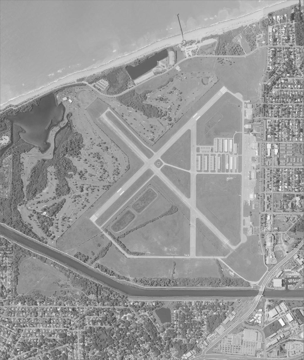
1 Preliminary Findings of Proposed Alternative The attached drawing provides a schematic layout of the proposed alternative that will be discussed on July 27, A full report will follow and should be posted on the City s website no later than July 19 th. The report will contain a greater explanation of how the team arrived at this layout, and a description of additional planning terminology used throughout the study. The contents contained on the attached drawing are still subject to further FAA review and comment as well as additional input from the U.S. Coast Guard.. It is important to note that if the City Council does move forward with this alternative for DY to show on the airport layout plan (ALP), the next step in the process would be for a full airspace review and FAA conditional approval of the ALP. The projects must then receive an environmental determination through the Environmental Assessment (EA) process prior to any design taking place. Introduction and Background On May 6 th, June 9 th, and June 30 th 2010 representatives from the City of Venice and DY Consultants met with FAA staff members from Orlando and Washington D.C. to develop alternatives to address community concerns expressed about homes located in the Runway 13 end Runway Protection Zone (RPZ) and minimizing physical impacts to the Venice Golf Association (VGA) golf course leasehold. A full range of alternatives were identified and reviewed that could potentially alleviate these concerns and at the same time enhance safety and maintain utility of the airport. The discussions addressed alternatives for each runway and ranged from shifting runway threshold locations to the use of Engineered Materials Arresting Systems (EMAS). DY was asked to further investigate the alternatives that were addressed during the working sessions. Several experts in their respective fields were also called upon by DY for additional information necessary to assist with the assessment of the alternatives. Goals and Objectives Goals and objectives of the planning effort and meetings with the FAA continue to be as follows: To the extent practicable, relocate the Runway 13 RPZ onto existing airport property. Maintain design standards and operational utility of a primary runway (same as Runway is today). o Equal landing and departure lengths o Approach capabilities should be equivalent to those that are presently in place on Runway o Maintain existing airport reference code If a standard, graded RSA cannot be achieved due to site constraints, provide equivalent RSA with a standard EMAS providing 70 knot capability. Provide for 600 feet of approach RSA. 1 DRAFT 7/9/2010
2 Increase the width and length of the Object Free Areas while minimizing impacts to the golf course. Provide adequate wind coverage. Conform to all C-II FAA design criteria to the extent practicable as set forth by FAA Advisory Circulars, Orders, regulations and standards. The ultimate objective of the working sessions with the FAA were to determine if a concept exists that could resolve Council and community concerns and at the same time satisfy FAA safety standards; maintain runway utility and avoid potential impacts to users and based aircraft. Potential solutions could not reduce runway utility or safety for any tenant, based aircraft or those that use the airport on a regular basis. Within each of the above cases several concepts were identified to address the key concerns previously identified ranging from shifting runway threshold locations to the use of Engineered Materials Arresting Systems (EMAS). Existing As- Is Conditions Runway The existing conditions will serve as a baseline to compare impacts of the alternatives. The Runway 13 RPZ contains 24 homes within its C-II dimensions. Alternatives will investigate ways to eliminate or reduce that number. The center of the Intracoastal Waterway is located approximately 1,300 feet from the approach end of Runway 31. The waterway is approximately 20 feet below ground elevation and is used intermittently by water vessels to and from the Gulf of Mexico. Sailboat mast heights above 50 feet would currently clear the existing 20:1 threshold siting surface but penetrate the existing 34:1 approach surface and 40:1 departure surface when passing by the runway. Research indicates that the vast majority of all sailboat masts are less than 65 feet. This is a manufacture design characteristic generated by the fact that federal highway bridge design criteria call for a 65-foot waterway clearance (mean high water). Therefore, any mast greater than 65 feet would typically not be able to pass under (non-opening) bridges located throughout the U.S. waterways system. DY is waiting for further information from the U.S. Coast Guard with regard to typical vessel and mast heights for this portion of the Intracoastal Waterway. Runway 4-22 The VGA golf course club house is located within the Runway 4 RSA, ROFA, and RPZ while the cart storage building is located within the Runway 4 RSA and ROFA. The golf course driving range and parts of the golf course that impede compliant RSA and ROFA standards would remain and the City would ask the FAA for modifications to standards. Runway use remains as-is fewer jets will use Runway 4-22 as a noise abatement runway on a consistent basis until it is rehabilitated from its present condition as well as it lacks a non-precision approach to either runway end. An existing condition that must be addressed in the alternative is the bascule bridge (Circus Bridge) over the Intracoastal Waterway on Business 41 approximately 1,200 to 1,300 feet 2
3 northeast of the existing end of Runway 22. The bridge has two leafs that open on demand for water vessels needing more than 25 feet of vertical clearance. The top elevation of the bridge when open is approximately 93 feet. The open height of the bridge must be considered for the approach, threshold siting and departures surfaces for Runway According to calculations conducted a 526 foot displaced threshold is necessary to clear the 20:1 approach surface. In addition the bridge is located within the future Runway 4 40:1 departure surface. Runway Object Free Area (ROFA) Deficiencies and the Golf Course The ROFA along the entire length of the west side of Runway does not meet current FAA design standards nor does the ROFA on either side of Runway 4-22 southwest of the runway intersection due to the location of the fence separating the airport from the Venice Golf Association (VGA) leasehold. The existing ROFA to Runway centerline dimension varies along the entire length of Runway anywhere from 280 to 290 feet. The existing ROFA standard dimension for this runway and Runway 4-22 is 400 feet. The Runway 4-22 ROFA southwest of the runway intersection varies on both sides due to the location of the golf course and narrows even further as it continues toward the runway end. To determine the maximum distance the fence could be relocated without an adverse impact to the golf course a golf course architect was asked to investigate the site and provide suggestions to accomplish this goal. It was determined that the fence located to the west of Runway which is south of the intersection of Runway 4-22 has no room for improvement. North of the Runway 4-22 intersection and west of Runway some improvement could be made with minor changes to the golf course. It was estimated that the maximum the fence could be relocated without adversely impacting the golf course would be 50 feet in some areas. To achieve this, no changes would be necessary to Existing Hole 22 due to its existing length and size. If the FAA desired, Hole 21 could be relocated and the cart path retained if the additional 50 feet were continued to the corner north of Runway The fence could conceivably be relocated along the north side of Runway 4-22 with no change to Hole 20 and converting Hole 19 from a Par 4 to a Par 3. The ROFA would continue to be nonstandard however the FAA does consider the improvement an enhancement to safety at the airport. Proposed Alternative Runway 13-31: Shift 727 feet Southeast, Construct EMAS, use Declared Distances Runway 4-22: Standard RSA Using Declared Distances and 160 feet to Runway 22. The Proposed Alternative as illustrated would involve the installation of engineered materials arresting systems (EMAS) at the Runway 31 end. A 1,000 foot standard RSA is equivalent to a 70 knot arrestor bed placed within the rear of a 600 foot RSA (for undershoot protection). The runway has been shifted to the maximum extent possible. As such in order to maintain 5,000 feet of useable runway and maintain its current utility, the placement of the Runway 13 RPZ has been located as far onto airport property as possible. 3
4 Runway is shifted 727 feet to the southeast, an additional 727 feet is added to the Runway 31 end and a 312 foot long by 100 or 150 wide EMAS bed is placed at the rear of a 600 foot RSA to achieve maximum takeoff and landing distance available in both directions. The EMAS has a 35 foot setback and a 254 foot displaced threshold would begin outside of the setback to provide a full 600 foot approach RSA. The declared distances or useable runway length available in this scenario would be as follows: Runway Declared Distances (in feet) Runway 13 Runway 31 TORA 5,000 5,000 TODA 5,000 5,000 ASDA 5,000 5,000 LDA 5,000 5,000 The Runway 13 approach would have a 605 foot displaced threshold. As a result of this displacement, aircraft would be at a higher altitude over the areas off the 13 end. During the last work session, the potential removal of 400 feet of pavement at the 13 end was discussed assuming the intermittent passage of a 50 foot mast sailboat in the ICW at the end of 31. Subsequent to that meeting, FAA staff asked for further research to be conducted considering a 65 mast. In that event, 122 feet of pavement at the end of the runway could be removed. Both scenarios continue to be researched for final selection of an appropriate mast height. The Relocating the Runway thresholds will require an airspace evaluation to adjust the existing GPS approach procedures. It appears that the 20:1 threshold siting surface will clear intermittent water vessels having a maximum mast height of 50 feet. The Omni Directional Approach Lights to Runway 31 would need to be assessed to determine if reconfiguring the system would be possible. Existing parallel Taxiway D would be extended to meet the new Runway 31 displaced threshold location. The published runway length would be 5,727 feet. The alternative would comply with FAA standards with the exception of the ROFA and two homes would be impacted within the RPZ. As the primary runway it maintains existing useable runway length available. This alternative will satisfy airport user needs that are presently based or frequent the airport. Runway 4-22 Runway 4-22 is the City s Preferred Noise Abatement Runway and all pilots are requested to use it when wind and weather conditions permit. Due to its existing condition it is not being used to its greatest potential. Once rehabilitated it is expected that it could be used to a much greater extent if utility is maintained or improved for existing jet users. Runway 4-22 was given an airspace overview by Mr. Gary Raymond an Airspace Evaluation Program Specialist to determine if a GPS approach with 1 mile visibility minimums or greater could be accommodated to each of the runway ends. According to 4
5 information available to him at this time, if the runways are marked for non-precision instrumentation the following could be obtained: Type Runway 04 Runway 22 LPV DA 212 visibility 1 SM Accurate Survey must be conducted of bridge LNAV/VNAV DA 262 visibility 1 SM DA 344 visibility 1.5 SM LNAV MDA 300 visibility 1 SM 440 visibility 1 SM In addition, the ROFA fence could be relocated 50 feet in most areas with minimal impact to the golf course. Hole 19 could be converted to a Par 3. A portion of the cart building, and clubhouse would remain in the ROFA and RPZ. A portion of Harbor Drive remains in the upper west corner of the ROFA as well. Due to the Circus Bridge height runway length would remain as it is today 5,000 feet however the Runway 22 end displacement will increase to 526 feet. By adding 160 feet to the Runway 22 end, the Accelerated Stop Distance Available (ASDA) length could be increased resulting in declared distances for this alternative as follows: Runway 4-22 Declared Distances (in feet) Runway 4 Runway 22 TORA 5,000 5,000 TODA 5,000 5,000 ASDA 5,000 5,000 LDA 5,000 4,314 As previously indicated GPS approaches to Runway 4-22 can likely be achieved and would be an additional encouragement for jet operators to use the runway on a more regular basis when possible. A survey completed in accordance with FAA AC , 17, and 18B would be required prior to full implementation by the FAA. The Runway 4 departure surface does not clear the Circus Bridge when it is open. Since this is an existing condition and the bridge is open only on demand it is unclear if published departure procedures can be put in place to alleviate the condition. This alternative also depicts Taxiway E at a standard centerline to runway centerline separation distance of 300 feet. Adjusting the taxiway to meet standards would require additional area between the existing fence and the taxiway safety area. This would require additional adjustments to the golf course. To maintain the proper Taxiway OFA criteria, the fence would actually need to be relocated 65.5 feet. Runway 4-22 would comply with FAA standards with the exception of the ROFA. A modification to standards would be required. The preliminary order of magnitude costs to implement the Proposed Alternative is as follows: 5
6 Criteria Evaluated to Date Existing Conditions Proposed Alternative Runway Proposed Alternative Runway 4 22 Total Preliminary Estimate Homes in RPZ Golf Course Modifications RSA/EMAS ROFA Taxiway E 24 none Standard RSA Nonstandard request mods. Portions of 2 N/A Move fence 50 where possible and relocate hole 21 Move fence 50 where possible and relocate Hole 19. Relocate driving range, entrance road and cart path Standard on 13 end EMAS on 31 end Standard using declared distances Note: Costs do not include rehabilitation of Runway 4- ALTERNATIVES FOR EXISTING PRIMARY RUNWAY Request modification Request modification Declared Distances GPS Approach Obstructions Preliminary Cost n/a n/a Yes both ends of 13/31 n/a Yes 5,000 available Published length 5,727 Yes 5,000 available Improved except for LDA on 22 4,965 Airspace evaluation required to re site for new threshold locations Airspace evaluation required to site threshold locations Yes Vessel Mast ok up to 50 feet Yes Vessel Mast less than 50 feet ok. Yes Circus Bridge $15 $20m $9.5 $10.5m $3.5 $4.5m $13.0 $15.0m 6 DRAFT 7/9/2010


7
New Opportunities PUBLIC WORKSHOP. Venice Municipal. Bringing g the pieces together
 Bringing g the PUBLIC WORKSHOP Venice Municipal Airport New Opportunities Presented for Venice City Council & Citizens of Venice September 25, 2009 Slide 1 Bringing g the Welcome & Introductions May 12th
Dallas Executive Airport
 648 DECLARED DISTANCE OPTION 1a DISPLACE 31 THRESHOLD BY 97 Considers RSA Limiting Factor No runway extensions 13 31 TORA 6,451 6,451 TODA 6,451 6,451 ASDA 5,958 6,451 LDA 5,958 6,354 Runway 17-35 (3,8
Safety, Infrastructure, and Tenant Improvement Project. Public Hearing Informational Brochure February 26, 2013
 New York State Department of Transportation Safety, Infrastructure, and Tenant Improvement Project Public Hearing Informational Brochure February 26, 2013 This DEIS/Draft EA evaluates the potential impacts
CHAPTER FOUR AIRPORT ALTERNATIVES
 4.0 INTRODUCTION CHAPTER FOUR The goal of the master planning process is to provide the City of New Smyrna Beach with an assessment of the adequacy and capabilities of the Airport as well as to identify
II. Purpose and Need. 2.1 Background
 II. 2.1 Background The Metropolitan Washington Airports Authority is preparing an Environmental Assessment of potential environmental impacts associated with proposed enhancements to the Runway 4-22 and
Hartford-Brainard Airport Potential Runway Closure White Paper
 Hartford-Brainard Airport Potential Runway 11-29 Closure White Paper June 2012 In recent years there has been discussion regarding the necessity of Runway 11-29 to the Hartford- Brainard Airport (HFD)
MASTER PLAN CONCEPT 1 DRAFT
 The Airport Master Plan Update for Dallas Executive Airport has included the development of aviation demand forecasts, an assessment of future facility needs, and the evaluation of airport development
CHAPTER 3 ALTERNATIVES CONSIDERED
 CHAPTER 3 ALTERNATIVES CONSIDERED 3.0 ALTERNATIVES The 2010 Stevensville Airport Master Plan contained five (5) airside development options designed to meet projected demands. Each of the options from
CHAPTER 2.0 ALTERNATIVES
 CHAPTER 2.0 ALTERNATIVES 2.1 INTRODUCTION 2.1.1 SCOPE OF THE ALTERNATIVES ANALYSIS This chapter summarizes the screening analysis conducted to identify the range of reasonable and practicable alternatives
ADVISORY CIRCULAR ON CALCULATION OF DECLARED DISTANCES
 Page 1 of 6 1. PURPOSE This Advisory circular (AC) provides guidance to operators to calculated declared distances at aerodrome for safe use of runway and promulgation of aeronautical data to the aeronautical
Addendum - Airport Development Alternatives (Chapter 6)
") Bowers Field Addendum - Airport Development Alternatives (Chapter 6) This addendum to the Airport Development Alternatives chapter includes the preferred airside development alternative and the preliminary
Bowers Field Addendum - Airport Development Alternatives (Chapter 6) This addendum to the Airport Development Alternatives chapter includes the preferred airside development alternative and the preliminary
Chapter 4 Airport Facility Requirements
 Chapter 4 Airport Facility Requirements Introduction CHAPTER 4 AIRPORT FACILITY REQUIREMENTS MAY 2013-1 Organization of Materials CHAPTER 4 AIRPORT FACILITY REQUIREMENTS MAY 2013-2 RPZ - ROAD RPZ - NON-AIRPORT
D.1 Introduction. Ronald Reagan Washington National Airport
 Appendix D. Alternatives D.1 Introduction Federal Aviation Administration (FAA) Orders 1050.1E, Environmental Impacts: Policies and Procedures, and 5050.4B, National Environmental Policy Act (NEPA) Implementing
Yolo County Airport. ALP Narrative Report. April Prepared by Mead & Hunt, Inc. for the County of Yolo, California
 Yolo County Airport ALP Narrative Report April 2016 Prepared by Mead & Hunt, Inc. for the County of Yolo, California Yolo County Airport ALP Narrative Report Prepared for the County of Yolo Mindi Nunes,
Appendix D August 2001 RUNWAY SAFETY Revised March 2002 AREA DETERMINATION RUNWAY 17-35
 Appendix D August 2001 RUNWAY SAFETY Revised March 2002 AREA DETERMINATION Master Plan Update RUNWAY 17-35 Hector International Airport SUFFICIENCY ANALYSIS Near the completion of the Master Plan Update
1) Rescind the MOD (must meet the standard); 2) Issue a new MOD which reaffirms the intent of the previous MOD; 3) Issue a new MOD with revisions.
 Rescind the MOD (must meet the standard); 2) Issue a new MOD which reaffirms the intent of the previous MOD; 3) Issue a new MOD with revisions.") ALBUQUERQUE INTERNATIONAL SUNPORT AIRCRAFT HOLD LINE LOCATION ANALYSIS WHITE PAPER JUNE 24, 2016 HOLD LINE LOCATION ISSUE The location of many of the taxiway hold lines at the Sunport do not meet current
ALBUQUERQUE INTERNATIONAL SUNPORT AIRCRAFT HOLD LINE LOCATION ANALYSIS WHITE PAPER JUNE 24, 2016 HOLD LINE LOCATION ISSUE The location of many of the taxiway hold lines at the Sunport do not meet current
Session. Arrester Systems, Declared Distances and Runway Excursion Prevention
 Session Arrester Systems, Declared Distances and Runway Excursion Prevention 1 Runway Excursion Toronto, Canada August 2, 2005 200 meters from end of runway 2 American Airlines Flight 331, Norman Manley
Lopez Island Airport Master Plan Update. Public Meeting June 15, 2017
 Lopez Island Airport Master Plan Update Public Meeting June 15, 2017 Master Plan Update Team Reid Middleton/Everett, WA Shannon Kinsella, Project Manager Melania Haagsma, Project Engineer Mead & Hunt/Tulsa,
CHAPTER 6 IDENTIFICATION AND EVALUATION OF ALTERNATIVES
 CHAPTER 6 IDENTIFICATION AND EVALUATION OF ALTERNATIVES This chapter identifies and evaluates development alternatives for the Duluth International Airport to satisfy the Airport Facility Requirements
FACILITY REQUIREMENTS SUMMARY OF KEY ISSUES OVERVIEW
 FACILITY REQUIREMENTS SUMMARY OF KEY ISSUES OVERVIEW This summary is intended to provide a brief overview of the key issues associated with conformance to FAA standards at Methow Valley State Airport.
5.0 ALTERNATIVES ANALYSIS
 5.0 ALTERNATIVES ANALYSIS The Alternative Analysis chapter describes and evaluates the various development alternatives considered for. In addition, it presents a preferred development plan that accommodates
MEETING MINUTES Page 1 of 5
 Page 1 of 5 50178.000 May 26, 2009 PROJECT PROJECT NO. MEETING DATE ISSUE DATE Citizens Advisory Committee Meeting MEETING LOCATION MEETING PURPOSE Amy Eckland ISSUED BY SIGNATURE PARTICIPANT See attached
ACTION TRANSMITTAL
 Transportation Advisory Board of the Metropolitan Council of the Twin Cities ACTION TRANSMITTAL 2018-16 DATE: February 9, 2018 TO: Transportation Advisory Board FROM: Technical Advisory Committee PREPARED
Chippewa-Eau Claire Metropolitan Planning Area Long Range Transportation Plan
 1.2.7 2010 Eau Claire County Comprehensive Plan According to Eau Claire County s most recent comprehensive plan, the County will limit land use development adjacent to EAU in order to preserve the ability
DRAFT MASTER PLAN UPDATE
 DRAFT MASTER PLAN UPDATE CHAPTER VI: AIRPORT LAYOUT PLAN NARRATIVE DRAFT REPORT APRIL 2017 PREPARED BY: Table of Contents WESTCHESTER COUNTY AIRPORT 6 AIRPORT LAYOUT PLAN NARRATIVE REPORT... 6-1 6.1 AGIS
Summary of Committee Discussion/Questions Metropolitan Transportation Services Senior Planner Russ Owen presented this item.
 Committee Report Business Item No. 2017-191 Transportation Committee For the Metropolitan Council meeting of September 13, 2017 Subject: Final Crystal Airport 2035 Long Term Comprehensive Plan (LTCP) Proposed
STAFF REPORT. Airport Land Use Plan Consistency Review: Santa Barbara Airport Master Plan. MEETING DATE: November 19, 2015 AGENDA ITEM: 7D
 STAFF REPORT SUBJECT: Airport Land Use Plan Consistency Review: Santa Barbara Airport Master Plan MEETING DATE: AGENDA ITEM: 7D STAFF CONTACT: Peter Imhof, Andrew Orfila RECOMMENDATION: Adopt findings
6.1 INTRODUCTION 6.2 AIRSIDE ALTERNATIVES NORTH PERRY AIRPORT MASTER PLAN UPDATE RUNWAY LENGTH REQUIREMENTS SECTION 6: ALTERNATIVES ANALYSIS
 6.1 INTRODUCTION In the previous chapter, facility needs for the 20-year planning horizon were identified. The next step in the planning process is to identify and evaluate the various ways certain facilities
AERONAUTICAL SURVEYS & INSTRUMENT FLIGHT PROCEDURES
 AERONAUTICAL SURVEYS & INSTRUMENT FLIGHT PROCEDURES Current as of November 2012 ALASKA AVIATION SYSTEM PLAN UPDATE Prepared for: State of Alaska Department of Transportation & Public Facilities Division
FACILITY REQUIREMENTS 5.1 Introduction
 Chapter 5 FACILITY REQUIREMENTS 5.1 Introduction The facility requirements section of this study defines the physical facilities needed to safely and efficiently accommodate the current and future aviation
Chapter 4.0 Alternatives Analysis
 Chapter 4.0 Alternatives Analysis Chapter 1 accumulated the baseline of existing airport data, Chapter 2 presented the outlook for the future in terms of operational activity, Chapter 3 defined the facilities
FORT LAUDERDALE-HOLLYWOOD INTERNATIONAL AIRPORT ENVIRONMENTAL IMPACT STATEMENT DRAFT
 D.3 RUNWAY LENGTH ANALYSIS Appendix D Purpose and Need THIS PAGE INTENTIONALLY LEFT BLANK Appendix D Purpose and Need APPENDIX D.3 AIRFIELD GEOMETRIC REQUIREMENTS This information provided in this appendix
GCAA ADVISORY CIRCULAR
 GUYANA CIVIL AVIATION AUTHORITY 73 High Street Kingston Georgetown GUYANA TEL. NOs: (592) 225 6822, 225 0778, 227 8111 FAX: (592) 225 6800 E-mail: director-general@gcaa-gy.org GCAA ADVISORY CIRCULAR AERODROME
Chapter 8.0 Implementation Plan
 Chapter 8.0 Implementation Plan 8.1 Introduction This chapter is the culmination of the analytical work accomplished in the previous chapters. The result is a prioritized list of the essential projects.
Chapter Six ALP Drawings. Tacoma Narrows Airport. Master Plan Update
 Chapter Six ALP Drawings Master Plan Update The master planning process for the (Airport) has evolved through efforts in the previous chapters to analyze future aviation demand, establish airside and landside
AIRSIDE CAPACITY AND FACILITY REQUIREMENTS
 AIRSIDE CAPACITY AND FACILITY REQUIREMENTS This Section investigates the capacity of the airport, its ability to meet current demand, and the facilities required to meet forecasted needs as established
Vista Field Airport. Master Plan Update. February, Prepared for: Port of Kennewick One Clover Island Kennewick, Washington
 Vista Field Airport February, 2006 Prepared for: Port of Kennewick One Clover Island Kennewick, Washington 99336 Prepared by: J-U-B ENGINEERS, Inc. 2810 W. Clearwater Avenue, Suite 201 Kennewick, Washington
APPENDIX E AIRFIELD PLANNING, DESIGN, & CONSTRUCTABILITY REVIEW
 APPENDIX E AIRFIELD PLANNING, DESIGN, & CONSTRUCTABILITY REVIEW The identification, evaluation, and refinement of the airfield development alternatives were subject to a variety of planning, engineering,
Chapter One PROJECT DESCRIPTION
 Chapter One PROJECT DESCRIPTION Environmental Impact Report Monterey Peninsula Airport 1.1 INTRODUCTION This Environmental Impact Report (EIR) analyzes and documents the potential environmental impacts
Facility Requirements
 C H A P T E R T H R E E Facility Requirements 3.0 OVERVIEW Airport planning for facility requirements is based upon addressing any existing issues and accommodating the probable demand that may occur over
Airport Obstruction Standards
 Airport Obstruction Standards Dr. Antonio Trani Department of Civil and Environmental Engineering Virginia Tech Outline of this Presentation Obstructions to navigation around airports Discussion of Federal
Appendix A - Glossary
 Appendix A - Glossary The terms and definitions here are relevant to airport design standards and retrieved from AC 150/5300-13A, Airport Design. A Accelerate-Stop Distance Available (ASDA). See Declared
Chapter 4.0 Facility Requirements
 Chapter 4.0 Facility Requirements Having inventoried the existing infrastructure and forecasted demand, determining airport facility requirements is the next essential step in the airport master planning
Dallas Executive Airport Town Hall Meeting April 3, 2014
 Dallas Executive Airport Town Hall Meeting April 3, 2014 Background 1,040 acre general aviation facility owned and operated by the City of Dallas 150 based aircraft including business jets and helicopters,
C > Capacity Analysis and Facility Requirements
 Buchanan Field Buchanan Field Airport Master Planning Program C. CAPACITY ANALYSIS & FACILITY REQUIREMENTS C > Capacity Analysis and Facility Requirements INTRODUCTION. The capacity of an airfield is primarily
Grove Field Airport Environmental Assessment
 Grove Field Airport Environmental Assessment Advisory Committee Meeting #2 December 9, 2008 Port of Camas-Washougal Conference Room 6:00 7:30 PM Agenda: Welcome and Overview Dave Ripp, Director, Port of
15 Precision Approach Path Indicator 33 None RSA 150 feet wide by 300 feet long 150 feet wide by 300 feet long
 The first (AMP) was completed in 1984 and updated in 2000. The current FAA approved Airport Layout Plan (ALP) is dated November 9, 2001. The FAA suggests updating the AMP every five year in accordance
Appendix C AIRPORT LAYOUT PLANS
 Appendix C AIRPORT LAYOUT PLANS Appendix C AIRPORT LAYOUT PLANS Airport Master Plan Santa Barbara Airport As part of this Airport Master Plan, the Federal Aviation Administration (FAA) requires the development
Airport Master Plan for. Brown Field Municipal Airport PAC Meeting #3
 Airport Master Plan for Brown Field Municipal Airport PAC Meeting #3 Public Meeting #1 > 8/24/17 from 5:30 to 8:00 pm > 41 attendees signed-in > Comments: > EAA area > Environmental constraints > Focus
Airlake Airport 2035 Long Term Comprehensive Plan (LTCP)
") Airlake Airport 2035 Long Term Comprehensive Plan (LTCP) Public Informational Meetings August 9 & 10, 2017 Draft LTCP Overview Briefing Agenda Airport Role & Context Existing Conditions & Previous Plan
Airlake Airport 2035 Long Term Comprehensive Plan (LTCP) Public Informational Meetings August 9 & 10, 2017 Draft LTCP Overview Briefing Agenda Airport Role & Context Existing Conditions & Previous Plan
Friedman Memorial Airport Authority. Regular Meeting September 4, 2012
 Friedman Memorial Airport Authority Regular Meeting September 4, 2012 UNFINISHED BUSINESS Airport Solutions Blaine County Report Airport Solutions City of Hailey Report Airport Solutions Airport Manager
PROPOSED HORIZONTAL LAYOUT FILLET DESIGN FOR ENTRANCE/EXIT TAXIWAYS
 PROPOSED HORIZONTAL LAYOUT FILLET DESIGN FOR ENTRANCE/EXIT TAXIWAYS INTRODUCTION The Zelienople Airport Authority (ZAA) has commenced engineering activities for the rehabilitation of Runway 17-35 to a
JANUARY 2013 Friedman Memorial Airport Pomeroy, Chris
 JANUARY 2013 Friedman Memorial Airport Pomeroy, Chris Friedman Memorial Airport / T-O Engineers Airport Alternatives Technical Analysis Table of Contents 1.0 Background and Purpose of Analysis... 1 1.1
Draft Concept Alternatives Analysis for the Inaugural Airport Program September 2005
 Draft Concept Alternatives Analysis for the Inaugural Airport Program September 2005 Section 3 - Refinement of the Ultimate Airfield Concept Using the Base Concept identified in Section 2, IDOT re-examined
CATCODE ] CATCODE
![CATCODE ] CATCODE](/thumbs/82/85644630.jpg "CATCODE ] CATCODE") Runways. FAC: 1111 CATCODE: 111111 OPR: AFCEC/COS OCR: AF/A3O-A 1.1. Description. The runway is the paved surface provided for normal aircraft landings and take offs. Runways are classified as either Class
Runways. FAC: 1111 CATCODE: 111111 OPR: AFCEC/COS OCR: AF/A3O-A 1.1. Description. The runway is the paved surface provided for normal aircraft landings and take offs. Runways are classified as either Class
Source: Chippewa Valley Regional Airport ASOS, Period of Record
 Chapter 1 Inventory Runway wind coverage is the percentage of time a runway can be used without exceeding allowable crosswind velocities. Allowable crosswind velocities vary depending on aircraft size
CHAPTER 1: INTRODUCTION
 CHAPTER 1: INTRODUCTION Purpose and Scope The information presented in this report represents the study findings for the 2016 Ronan Airport Master Plan prepared for the City of Ronan and Lake County, the
Table of Contents. List of Tables. Cincinnati/Northern Kentucky International Airport 2035 Master Plan Update
 Table of Contents 7.1. Airport Layout Plan (Existing Conditions)... 2 7.2. Airport Layout Plan (Future Conditions)... 3 7.3. Technical Data Sheet... 5 7.4. Commercial Terminal Area Drawing... 5 7.5. East
Milton. PeterPrinceAirportislocatedinSantaRosaCounty, approximatelythreemileseastofmilton.
 Milton GeneralAviationAirport PeterPrinceAirportislocatedinSantaRosaCounty, approximatelythreemileseastofmilton. Existing Facilities Peter Prince Airport is served by one runway, Runway 18/36, 3,700 feet
According to FAA Advisory Circular 150/5060-5, Airport Capacity and Delay, the elements that affect airfield capacity include:
 4.1 INTRODUCTION The previous chapters have described the existing facilities and provided planning guidelines as well as a forecast of demand for aviation activity at North Perry Airport. The demand/capacity
Chapter Four ALTERNATIVES
 Chapter Four ALTERNATIVES Master Plan Update This chapter walks through the process of identifying and evaluating development alternatives to serve the (Airport) in the near-term to the distant future.
Chapter 9 - AIRPORT SYSTEM DESIGN
 Chapter 9 - AIRPORT SYSTEM DESIGN 9.01 GENERAL This chapter discusses the development program for Dutchess County Airport to the year 2020. This airport system design is based upon the airport's existing
Executive Summary. MASTER PLAN UPDATE Fort Collins-Loveland Municipal Airport
 Executive Summary MASTER PLAN UPDATE Fort Collins-Loveland Municipal Airport As a general aviation and commercial service airport, Fort Collins- Loveland Municipal Airport serves as an important niche
TECHNICAL REPORT #7 Palm Beach International Airport Airport Layout Plan
 TECHNICAL REPORT #7 Palm Beach International Airport Airport Layout Plan Technical Report #7 Palm Beach International Airport Layout Plan Palm Beach International Airport Prepared for Palm Beach County
Chapter 4 Airport Capacity Assessment and Identification of Facility Needs
 Chapter 4 Airport Capacity Assessment and Identification of Facility Needs 4.1 Introduction The purpose of the airport capacity assessment and identification of facility needs is to evaluate the single
Merritt Island Airport
 APPENDIX E RUNWAY SAFETY AREA DETERMINATION The purpose of this analysis is to evaluate existing deficiencies for Runway Safety Area (RSA) at Merritt Island Airport (COI) and to propose alternatives that
Appendix D Airfield Ongoing Projects Alternatives
 Appendix D Appendix D D.1 Introduction The set of alternatives for each of the airfield facilities was compared with respect to each other and the existing condition. 1 The screening and evaluation process
1.1.3 Taxiways. Figure 1-15: Taxiway Data. DRAFT Inventory TYPICAL PAVEMENT CROSS-SECTION LIGHTING TYPE LENGTH (FEET) WIDTH (FEET) LIGHTING CONDITION
 WIDTH (FEET) LIGHTING CONDITION") 1.1.3 Taxiways EWN has an extensive network of taxiways and taxilanes connecting the terminal, air cargo, and general aviation areas with the runways as listed in Figure 1-15. A 50-foot wide parallel taxiway
1.1.3 Taxiways EWN has an extensive network of taxiways and taxilanes connecting the terminal, air cargo, and general aviation areas with the runways as listed in Figure 1-15. A 50-foot wide parallel taxiway
Saint Petersburg-Clearwater International Airport. Airspace & Instrument Approach Analysis
 Saint Petersburg-Clearwater International Airport Airspace & Instrument Approach Analysis February 23, 2005 Jeppesen Boeing Jeppesen Government / Military Services Group Airspace Services Division AIRSPACE
Lake Tahoe Airport Master Plan
 Lake Tahoe Airport Master Plan City Council Briefing October 20, 2015 What is an Airport Master Plan? a comprehensive study of an airport [that] usually describes the short, medium, and long term development
Morristown Municipal Airport Runway 5-23 Rehabilitation Environmental Assessment
 1.0 INTRODCTION Morristown Municipal Airport (hereinafter referred to as MM or Airport ) is a busy general aviation reliever airport owned by the Town of Morristown and operated by DM AIRPORTS, LTD. (hereinafter
Lake Tahoe Airport Master Plan Public Meeting March 16, 2015
 Lake Tahoe Airport Master Plan Public Meeting March 16, 2015 What is an Airport Master Plan? a comprehensive study of an airport [that] usually describes the short, medium, and long term development plans
TABLE OF CONTENTS. 1.0 PROJECT SUMMARY INTRODUCTION Scope Summary/Methodology RSA-Runway Environment Relationship...
 TABLE OF CONTENTS 1.0 PROJECT SUMMARY...1 1.1 INTRODUCTION...1 1.1.1 Scope Summary/Methodology...1 1.1.2 RSA-Runway Environment Relationship...2 1.2 EXISTING CONDITIONS...4 1.2.1 Airfield Overview...4
Tallahassee International Airport Master Plan. Technical Advisory Committee Meeting #2 October 19, 2016
 Tallahassee International Airport Master Plan Technical Advisory Committee Meeting #2 October 19, 2016 Agenda Welcome / Introductions Master Plan Process and Project Status Forecast of Aviation Demand
LOS ANGELES INTERNATIONAL AIRPORT MAY 2014
 1. Purpose and Need 1.1 Introduction The City of Los Angeles, through its aviation department, Los Angeles World Airports (LAWA), proposes to construct improvements to the Runway Safety Area (RSA) for
Runway Length Analysis Prescott Municipal Airport
 APPENDIX 2 Runway Length Analysis Prescott Municipal Airport May 11, 2009 Version 2 (draft) Table of Contents Introduction... 1-1 Section 1 Purpose & Need... 1-2 Section 2 Design Standards...1-3 Section
Study Committee Meeting. September 2015
 W ki P T / Working Paper Two/ Study Committee Meeting September 2015 Agenda Introductions and Opening Comments Project Overview, Process, and Schedule Review Materials from Working Paper Two Comments,
Chapter 5 Airport Facility Requirements
 Chapter 5 Airport Facility Requirements Introduction The evaluation of airport facility requirements uses the results of the inventory and forecasts contained in Chapters Two and Three, as well as established
Airport Master Plan for Montgomery-Gibbs Executive Airport PAC Meeting #3
 Airport Master Plan for Montgomery-Gibbs Executive Airport PAC Meeting #3 Agenda > Introductions > Public Meetings Overview > Working Paper 3 - Facility Requirements > Working Paper 4 - Environmental Baseline
Chapter Three AIRPORT FACILITY REQUIREMENTS/ALTERNATIVES
 Chapter Three AIRPORT FACILITY REQUIREMENTS/ALTERNATIVES Airport Layout Plan Report In this chapter, existing components of the Airport are evaluated so that the capacities of the overall system are identified.
Draft Concept Alternatives Analysis for the Inaugural Airport Program September 2005
 Draft Concept Alternatives Analysis for the Inaugural Airport Program September 2005 Section 1 - Introduction This report describes the development and analysis of concept alternatives that would accommodate
Draft Concept Alternatives Analysis for the Inaugural Airport Program September 2005
 Section 10 Preferred Inaugural Airport Concept 10.0 Introduction The Preferred Inaugural Airport Concept for SSA was developed by adding the preferred support/ancillary facilities selected in Section 9
Appendix D Project Newsletters. Tacoma Narrows Airport. Master Plan Update
 Appendix D Project Newsletters Tacoma Narrows Airport Master Plan Update This appendix contains the newsletters distributed throughout the project. These newsletters provided updates and information on
Airport Master Plan Update June 15, 2017
 Airport Master Plan Update June 15, 2017 www.harveyfield.com The Master Plan is a 20-year plan to understand the needs of current and future users of the Airport. This is important to ensure that safe
3.1 Facility Requirements Overview Airfield Facility Requirements... 1
 Table of Contents 3.1 Overview... 1 3.2 Airfield... 1 Airspace Capacity...1 Airside Capacity... 2 Aircraft Mix Index... 3 Arrivals Percentage... 4 Touch-and-Go Percentage... 4 Taxiway Access Factors...
Chapter 1 Introduction and Project Overview
 Chapter 1 Introduction and Project Overview Kittitas County in cooperation with the Federal Aviation Administration (FAA) is updating the Airport Master Plan for Bowers Field Airport (FAA airport identifier
The purpose of this Demand/Capacity. The airfield configuration for SPG. Methods for determining airport AIRPORT DEMAND CAPACITY. Runway Configuration
 Chapter 4 Page 65 AIRPORT DEMAND CAPACITY The purpose of this Demand/Capacity Analysis is to examine the capability of the Albert Whitted Airport (SPG) to meet the needs of its users. In doing so, this
IDENTIFICATION AND EVALUATION OF ALTERNATIVES ST. PETERSBURG-CLEARWATER INTERNATIONAL AIRPORT
 IDENTIFICATION AND EVALUATION OF ALTERNATIVES ST. PETERSBURG-CLEARWATER INTERNATIONAL AIRPORT 7 7.1 GENERAL The primary objective of this chapter is to evaluate potential development alternatives and identify
Chapter 4 Airport Facility Requirements
 Chapter 4 Airport Facility Requirements The evaluation of airport facility requirements uses the results of the inventory and forecasts contained in Chapters Two and Three, as well as established planning
STAFF REPORT. Airport Land Use Plan Consistency Review: Old Town Village Mixed Use Project City of Goleta. MEETING DATE: June 18, 2015 AGENDA ITEM: 5M
 STAFF REPORT SUBJECT: Airport Land Use Plan Consistency Review: Old Town Village Mixed Use Project City of Goleta MEETING DATE: AGENDA ITEM: 5M STAFF CONTACT: Peter Imhof, Andrew Orfila RECOMMENDATION:
Appendix F Cultural Resource Consultation
 Appendix F Cultural Resource Consultation FAA Consultation Letter to the California State Historic Preservation Officer Response Letter from the California State Historic Preservation Officer STATE
The following criteria shall be applied within the boundaries of the AO District:
 Sec. 419 (a) Purpose AIRPORT OVERLAY DISTRICT (AO) The purpose of the Airport Overlay District is to regulate and restrict the height of structures, objects, or natural growth, regulate the locations of
CESSNA CITATION IIB PW JT15D-4 INTRODUCTION. Runway Analysis provides the means to determine maximum allowable takeoff and landing weights based upon:
 CESSNA CITATION IIB PW JT15D-4 INTRODUCTION Runway Analysis provides the means to determine maximum allowable takeoff and landing weights based upon: Airport characteristics consisting of airport elevation,
Chapter 4 Facility Requirements
 Chapter 4 Facility Requirements Introduction This chapter evaluates the existing airport facilities and identifies improvements needed to effectively meet the forecasted demand levels discussed in the
Billy Bishop Toronto City Airport; Porter Airlines Proposal Review; Interim Results/Findings, Airbiz, 26 June 2013
 Billy Bishop Toronto City Airport - Outstanding Questions for Transport Canada EXECUTIVE SUMMARY Transport Action has reviewed the reports published by Airbiz and LPS Avia Consulting and found that they
Notice and Opportunity to Comment on New Proposed Passenger Facility Charge (PFC) New Application
 New Application") July 3, 2018 Notice and Opportunity to Comment on New Proposed Passenger Facility Charge (PFC) New Application The City of Kansas City (City), Missouri through its Aviation Department ( the Department
July 3, 2018 Notice and Opportunity to Comment on New Proposed Passenger Facility Charge (PFC) New Application The City of Kansas City (City), Missouri through its Aviation Department ( the Department
CHAPTER 3 AIRPORT FACILITY REQUIREMENTS
 CHAPTER 3 AIRPORT FACILITY REQUIREMENTS 3.1 Introduction The existing runway and taxiway system at Skyhaven Airport provides more than adequate operational capacity to accommodate future peak hour and
Preferred Alternative Summary
 Tacoma Narrows Airport Master Plan Update Preferred Alternative Summary The Preferred Alternative represents Pierce County s vision for the long-term development of the Tacoma Narrows Airport. This Alternative
chapter 5 Recommended Master Plan Concept airport master plan MASTER PLAN CONCEPT
 chapter 5 Recommended Master Plan Concept airport master plan The planning process for Coolidge Municipal Airport has included several analytical efforts in the previous chapters intended to project potential
4.0 AIRFIELD CAPACITY & FACILITY REQUIREMENTS
 4.0 AIRFIELD CAPACITY & FACILITY REQUIREMENTS A key step in the Airport Master Plan (AMP) process is determining future requirements for airport facilities that will allow for airside and landside development