II. Purpose and Need. 2.1 Background
|
|
|
- Sherilyn Phillips
- 5 years ago
- Views:
Transcription
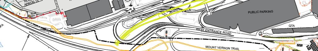
1 II. 2.1 Background The Metropolitan Washington Airports Authority is preparing an Environmental Assessment of potential environmental impacts associated with proposed enhancements to the Runway 4-22 and Runway Runway Safety Areas and related improvements at Ronald Reagan Washington National Airport. The EA is being prepared pursuant to the requirements and guidelines of FAA Order E, 1 FAA Order B, 2 and the FAA Environmental Desk Reference for Airport Actions. 3 The objectives of this section are to: Define the for the Proposed Action, where Need is defined as the problem the Authority is facing and Purpose is defined as the Authority s proposed solution to the problem Describe the Authority s Proposed Action Identify the actions requested of the FAA Define the estimated timeframe for FAA actions and implementation of the Proposed Action The Authority operates the Airport, which occupies approximately 733 acres of land and 127 acres of water along the western shore of the Potomac River in the Commonwealth of Virginia. The Airport is located in Arlington County, immediately north of the City of Alexandria, Virginia, and across the Potomac River from Washington, D.C. The regional setting of the Airport is shown on Exhibit II-1. The Airport has three runways: primary Runway 1-19 and crosswind Runways 4-22 and Runway 1-19 accommodates approximately 92 percent of the aircraft landings and take-offs at the Airport; Runways 4-22 and accommodate approximately 2 percent and 6 percent of the Airport's landings and take-offs, respectively. The current Airport Layout Plan is shown on Exhibit II Runway Safety Area Regulatory Background and Design Standards An RSA is a defined surface surrounding a runway. The RSA is intended to provide a measure of safety in the event of an aircraft excursion from the runway by significantly reducing the extent of personal injury and aircraft damage during overruns, undershoots, and veer-offs. 4 FAA Order established the Runway Safety Area Program (RSAP) and the procedures that the FAA follows in implementing the RSAP. The RSAP requires that all RSAs at federally obligated airports and at airports certificated under Title 14 CFR Part 139, Certification and Operations: Land Airports Serving Certain Air Carriers, shall conform to the standards contained in FAA AC 150/ , Airport Design, to the extent practicable. 5 The Airport is a federally obligated airport certificated under 14 CFR Part Federal Aviation Administration, Order E, Environmental Impacts: Policies and Procedures, Change 1, March 20, Federal Aviation Administration, Order B, National Environmental Policy Act (NEPA) Implementing Instructions for Airport Actions, April 28, Federal Aviation Administration, Environmental Desk Reference for Airport Actions, October Federal Aviation Administration Order , Runway Safety Area Program, Appendix 2. Supporting Documentation for RSA Determinations, Section 4. Considerations in Addressing Alternatives. October 1, Federal Aviation Administration, Advisory Circular 150/ , Airport Design, Change 8, September 30, Draft Environmental Assessment II-1 November 2010
2 THIS PAGE LEFT INTENTIONALLY BLANK Draft Environmental Assessment II-2 November 2010

3 Ronald Reagan Washington National Airport Source: MapPoint Prepared by: Ricondo & Associates, Inc., February Exhibit II-1 not to scale north Regional Setting Draft Environmental Assessment II-3 November 2010
4 THIS PAGE LEFT INTENTIONALLY BLANK Draft Environmental Assessment II-4 November 2010


5 Ronald Reagan Washington National Airport Source: Metropolitan Washington Airports Authority, Office of Engineering, May Prepared by: Ricondo & Associates, Inc., June Exhibit II-2 Airport Layout Plan Not to Scale Draft Environmental Assessment II-5 November 2010
6 THIS PAGE LEFT INTENTIONALLY BLANK Draft Environmental Assessment II-6 November 2010
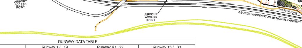
7 FAA Order , Financial Feasibility and Equivalency of Runway Safety Area Improvements and Engineered Material Arresting Systems, is intended to assist: (a) airport sponsors, such as the Authority, in developing a sound proposed action for RSA improvements for environmental review purposes, and (b) FAA Regional Airports Division Managers in preparing an RSA practicability determination, as required by FAA Order FAA Order provides guidance for comparing RSA improvement alternatives with improvements that use an Engineered Materials Arresting System and for determining the maximum financially feasible cost for RSA improvements, whether or not they involve EMAS. EMAS uses materials of closely controlled strength and density placed at the end of a runway to stop or greatly slow an aircraft that overruns the runway. The best material found to date is a lightweight, crushable concrete. When an aircraft rolls into an EMAS arrestor bed, the tires of the aircraft sink into the lightweight concrete and the aircraft is decelerated by having to roll through the material. 7 The U.S. DOT Appropriations Act for FFY 2006 (House Resolution (HR) ) requires the operators of all airports certificated under 14 CFR Part 139 to comply with FAA regulatory requirements for RSAs by FFY The Act also requires the FAA to report annually on its progress toward achieving compliance. FAA AC 150/ provides dimensional requirements for RSAs based on the physical and operating characteristics of the design aircraft operating at an airport. Based on the characteristics of aircraft operating on Airport Runways 4-22 and 15-33, the current standard RSA dimensions are: 500 feet wide and centered on the centerline of the runway 1,000 feet beyond the departure runway end 600 feet prior to the landing threshold Prior to September 30, 2004, the standard RSA dimensions prior to and beyond the end of the runway for the type of aircraft operating on Runways 4-22 and were 1,000 feet. FAA AC 150/ , Change 8, reduced the RSA dimension prior to the landing threshold from 1,000 feet to 600 feet. Exhibits II-3 and II-4 depict the standard RSA overlaid onto existing Runways 4-22 and 15-33, respectively, illustrating the shift in dimensions at the runway ends depending on the direction in which the aircraft operates. For example, when aircraft land on and take off from Runway 4 (i.e., operate in a northeast flow), the dimensional requirements for the RSA would be 600 feet prior to the Runway 4 threshold and 1,000 feet beyond the end of the runway (i.e., the northeast end of the runway). Conversely, in southwest flow conditions with landings on and take-offs from the Runway 22 end, the dimensional requirements for an RSA would be 600 feet prior to the Runway 22 threshold and 1,000 feet beyond the end of the runway (i.e., the southwest end of the runway). Similarly, when aircraft land on and take off from Runway 15 (i.e., operate in a southeast flow), the dimensional requirements for the RSA would be 600 feet prior to the Runway 15 threshold and 1,000 feet beyond the end of the runway (i.e., the southeast end of the runway). Conversely, in northwest flow conditions with landings on and take-offs from the Runway 33 end, the dimensional requirements for an RSA would be 600 feet prior to the Runway 33 threshold and 1,000 feet beyond the end of the runway (i.e., the northwest end of the runway). 6 7 Federal Aviation Administration Order , Financial Feasibility and Equivalency of Runway Safety Area Improvements and Engineered Material Arresting Systems, Section 1. March 15, Federal Aviation Administration, Fact Sheet, Engineered Material Arresting Systems, August 11, Draft Environmental Assessment II-7 November 2010
8 THIS PAGE LEFT INTENTIONALLY BLANK Draft Environmental Assessment II-8 November 2010
9 600 FT 500 FT 1000 FT RUNWAY END SOUTHWEST FLOW RUNWAY 22 ARRIVALS AND DEPARTURES RUNWAY 4-22 (4,911 FT) NORTHEAST FLOW RUNWAY 4 ARRIVALS AND DEPARTURES RUNWAY 4-22 (4,911 FT) RUNWAY 22 THRESHOLD 1000 FT RUNWAY END 500 FT 600 FT RUNWAY 4 THRESHOLD Source: Ricondo and Associates, January Prepared by: Ricondo & Associates, Inc., February Exhibit II-3 not to scale north Standard RSA Design Dimensions Overlaid on Existing Runway 4-22 Draft Environmental Assessment II-9 November 2010
10 THIS PAGE LEFT INTENTIONALLY BLANK Preliminary Draft Environmental Assessment #2 II-10 November 2010
11 1000 FT RUNWAY END NORTHWEST FLOW RUNWAY 33 ARRIVALS AND DEPARTURES 600 FT RUNWAY 15 THRESHOLD RUNWAY (5,204 FT) SOUTHEAST FLOW RUNWAY 15 ARRIVALS AND DEPARTURES RUNWAY (5,204 FT) 600 FT RUNWAY 33 THRESHOLD 500 FT 1000 FT RUNWAY END 500 FT Source: Ricondo and Associates, January Prepared by: Ricondo & Associates, Inc., February Exhibit II-4 not to scale north Standard RSA Design Dimensions Overlaid on Existing Runway Draft Environmental Assessment II-11 November 2010
12 THIS PAGE LEFT INTENTIONALLY BLANK Draft Environmental Assessment II-12 November 2010
13 Within the RSA, the FAA requires surface conditions to be: Cleared, graded, and without potentially hazardous ruts, humps, depressions, or other surface variations; Drained by grading or storm sewers to prevent water accumulation; Capable, under dry conditions, of supporting snow removal equipment, aircraft rescue and fire fighting equipment, and the occasional passage of an aircraft without causing structural damage to the aircraft; and Free of objects, except for objects that need to be located in the RSA because of their function Existing Conditions In its Runway Safety Area Determination 8 prepared in 2007, the FAA found that the Runway 4-22 and Runway RSAs required enhancements to comply with FAA Order and FAA AC 150/ Table II-1 presents a comparison of the findings of the FAA s Runway Safety Area Determination and FAA RSA design standards. Table II-1 Comparison of FAA RSA Determination and FAA RSA Design Standards RSA Determination Design Standard Runway 4 Departure 500 feet by 200 feet a/ 500 feet by 1,000 feet Runway 22 Departure 500 feet by 950 feet 500 feet by 1,000 feet Runway 15 Departure 500 feet by 120 feet b/ 500 feet by 1,000 feet Runway 33 Departure 500 feet by 170 feet 500 feet by 1,000 feet Notes: a/ The runway meets the Potomac riverbank at an angle, and does not meet RSA standards for the entire width of the RSA. The 200-foot-long RSA was measured along the extended runway centerline. b/ The runway meets the Potomac riverbank at an angle, and does not meet RSA standards for the entire width of the RSA. The 120-foot-long RSA was measured along the extended runway centerline. Source: Federal Aviation Administration, Runway Safety Area Determination: Ronald Reagan-Washington National Airport, Virginia (DCA), February 21, Prepared by: Ricondo & Associates, Inc., November Statement The Problem (Need) The FAA has determined that the RSAs for departures from Runways 4, 22, 15 and 33 do not meet the 1,000-foot FAA design standard. The specific RSA deficiencies are presented in Table II-1 above. As the operator of the Airport a federally obligated airport certificated under 14 CFR Part 139 the Authority is obligated by FAA Order and the U.S. DOT Appropriations Act for FFY 2006 (HR ) to comply with FAA regulatory requirements for RSAs by Federal Aviation Administration, Runway Safety Area Determination, Ronald Reagan-Washington National Airport, Virginia (DCA), February 21, Draft Environmental Assessment II-13 November 2010
14 2.2.2 The Authority s Solution (Purpose) FAA Order identifies the alternatives that must be analyzed when an RSA does not comply with applicable FAA AC 150/ standards. 9 Those alternatives are to: Construct a standard RSA; Relocate, shift, and/or realign the runway; Reduce the length of the runway; Implement a combination of relocating, shifting, and/or realigning the runway and reducing runway length; Use declared distances; or Use EMAS. The criteria and screening process used to evaluate these alternatives are discussed in Section III. The construction of standard RSAs was eliminated from detailed consideration early in the screening process because that alternative would have significant impacts on the Potomac River at the Runway 22 and 33 ends and on the George Washington Memorial Parkway at the Runway 33 end. The cost to implement this alternative would exceed the costs of implementing other alternatives and would be impracticable. The Authority believes it is important to increase the runway length available for take-offs from Runway 4 by 89 feet, to a total of 5,000 feet, and to maintain the existing length of Runway However, the Authority also believes that the runway length available for landings on Runway 4-22 can be reduced by 91 feet, from 4,911 feet to 4,820 feet, and that the runway length available for take-offs from and landings on Runway 22 can be reduced by 491 feet, from 4,911 feet to 4,420 feet. The principal runway elements of the Proposed Action are presented in Table II-2. Table II-2 Principal Runway Elements of Proposed Action Runway 4 End Runway 22 End Runway 15 End Runway 33 End Relocate Runway End Yes Yes Yes Yes Displace Threshold Yes Yes No No Shift Runway along Axis No No Yes Yes Use Declared Distances No Yes No No Use EMAS No Yes Yes Yes Source: Federal Aviation Administration, Ronald Reagan International Airport, Runway Safety Area Determination, February 21, Prepared by: Ricondo & Associates, Inc., November Based on consultations with the FAA, the EMAS manufacturer, and the airlines, the Authority selected: a) the A-319 with an adjusted maximum take-off weight (A-MTOW) of 144,500 pounds as the critical design aircraft for overruns of Runway 4; b) the Embraer EMB-145 with an A-MTOW of 34,000 pounds as the critical design aircraft for overruns of Runway 15; and c) the A-319 with an A- MTOW of 138,000 pounds as the critical design aircraft for overruns of Runway 33. Additional 9 Federal Aviation Administration, Order , Runway Safety Area Program, Appendix 2, "Supporting Documentation for RSA Determinations," Section 3, "Alternatives to Be Considered," October 1, Draft Environmental Assessment II-14 November 2010
15 information on the rationale for the selection of the critical design aircraft is provided in Appendix D., Section D and D Within the context of the requirements of FAA Order and FAA AC 150/ , the Authority has conducted studies addressing enhancements to the Runway 4-22 and Runway RSAs. The more recent studies continued the planning documented in the earlier studies: Ricondo & Associates, Inc., Runway Safety Area Study, Phase I Operational Alternatives, First Draft, March HNTB Corporation, Final Report, Runway Safety Area Study, Phase II, Ronald Reagan Washington National Airport, March 25, Following the completion of the Phase II Study, the Authority continued its planning efforts. The Phase II Study considered the use of EMAS that would stop the critical design aircraft that overruns the runway and exits the runway at speeds up to 70 knots. The Post-Phase II alternatives introduced the use of EMAS that would stop the critical design aircraft that overruns the runway and exits the runway at speeds up to 40 knots. Building on the analyses in these studies, the Authority has developed a proposed solution to the need for enhanced Runway 4-22 and Runway RSAs, as follows: Runway 4-22 Relocating the Runway 4 end by 460 feet to the southwest Relocating the Runway 4 threshold by 260 feet to the southwest Increasing the available runway length for take-offs from Runway 4 from 4,911 feet to 5,000 feet Decreasing the available runway length for landings on Runway 4 from 4,911 feet to 4,800 feet. Designating declared distances of 4,400 feet for landings on and take-offs from Runway 22 (a reduction of 511 feet from the existing runway length of 4,911 feet) Extending Taxiway B to the relocated Runway 4 end Installing EMAS (170 feet wide by 336 feet long) at the existing Runway 22 end Relocating the Runway 22 end 371 feet to the southwest (35 feet from the edge of the EMAS bed) Constructing a new taxiway connector to the relocated Runway 22 end Runway Shifting Runway by 270 feet to the southeast Installing EMAS (170 feet wide by 353 feet long) at the relocated Runway 15 end Installing EMAS (170 feet wide by 140 feet long) at the relocated Runway 33 end Constructing new taxiway connectors to the relocated runway ends Placing fill in the Potomac River to support the Runway 33 RSA Approach Aids Relocating three existing visual glide slope indicators used for Runways 22, 15, and 33 Other Elements Rerouting existing service roads Grading and stabilizing soil in the RSA Draft Environmental Assessment II-15 November 2010
16 The proposed solution described in this section, and the related improvements required to implement this solution, are referred to as the Proposed Action and are described in Section Summary of Authority s The Authority is obligated to enhance the Runway 4-22 and Runway RSAs as needed to comply with FAA Order and FAA AC 150/ by FFY Implementing the Proposed Action would enable the Authority to bring the Runway 4-22 and Runway RSAs into compliance with FAA Order and FAA AC 150/ for ARC C-III aircraft. 2.3 Proposed Action The Authority s Proposed Action includes the key elements described below. Except for the protrusion of the RSA at the Runway 33 end into the Potomac River, all construction would take place on Airport land. Exhibits II-5 and II-6 illustrate the Proposed Action for Runway 4-22 and Runway 15-33, respectively Runway 4-22 The Proposed Action for Runway 4-22 involves: Extending the Runway 4 end by 460 feet to the southwest. The runway pavement would be extended 460 feet to the southwest at the same width as the current Runway 4-22 pavement. Runway edge lighting would be added along the extended runway pavement. Relocating the Runway 4 threshold by 260 feet to the southwest. A runway threshold should be located at the beginning of the full-strength runway pavement. A threshold located at a point on a runway other than the designated runway end is referred to as a displaced threshold. The displaced area is available for aircraft take-off or rollout, but not for landing. A displaced threshold does not mark the end of a runway. The threshold for landings on Runway 4 would be displaced 200 feet from the edge of the extended Runway 4 pavement, thereby relocating the threshold for landings 260 feet southwest of its current location. The displacement is required to provide a 600-foot-long RSA prior to the displaced threshold. The displaced threshold would include new in-pavement lights. The runway length available for landing on Runway 4 would be reduced from 4,911 feet to 4,800 feet. Designating declared distances of 4,400 feet for take-offs from and landings on Runway 22. Declared distances would allow the Authority to establish the runway length at a specific distance regardless of the length of pavement available to establish the beginning and ending of the RSA. The use of these declared distances effectively reduces the length of runway available for take-offs from and landings on Runway 22 by 511 feet. Extending Taxiway B to the relocated Runway 4 end. Taxiway B would be extended to the new Runway 4 end. New taxiway edge lights would be installed along the length of the extended pavement. Installing EMAS (170 feet wide by 336 feet long) at the existing Runway 22 end. The EMAS would begin at the existing Runway 22 end and extend southwest 336 feet. The EMAS would be capable of stopping the critical design aircraft (i.e., Airbus A-319 with an A-MTOW of 144,500 pounds) that overruns Runway 4 and exits the runway at speeds up to 70 knots. Draft Environmental Assessment II-16 November 2010
17 Draft Environmental Assessment II-17 November 2010
18 THIS PAGE LEFT INTENTIONALLY BLANK Draft Environmental Assessment II-18 November 2010
19 Draft Environmental Assessment II-19 November 2010
20 THIS PAGE LEFT INTENTIONALLY BLANK Draft Environmental Assessment II-20 November 2010
21 Relocating the Runway 22 end 371 feet to the southwest. Takeoffs from Runway 22 would begin 35 feet southwest of the EMAS bed. Constructing a new taxiway connector to the relocated Runway 22 end. A new taxiway connector would connect the relocated Runway 22 end to Taxiway M. New taxiway edge lights would be installed along the length of the new pavement Runway The Proposed Action for Runway involves: Shifting Runway feet to the southeast. To avoid impacts to the George Washington Memorial Parkway and the bike path adjacent to the existing Runway 33 end, the Proposed Action includes shifting Runway by 270 feet to the southeast along its axis. The runway pavement would be extended 245 feet to the south at the same width as the current Runway pavement. Runway edge lighting would be added along the extended runway pavement. The runway length for landings on and take-offs from Runway would remain the same, 5,204 feet. Installing EMAS (170 feet wide by 353 feet long) at the relocated Runway 15 end. The location of the northwest edge of the EMAS bed at the Runway 15 end is controlled by the location of the service road. At present, the service road crosses through the RSA at the Runway 15 end. The service road cannot cross through the EMAS bed because the vehicle traffic would sink into the EMAS material. Therefore, the service road must be relocated around the end of the EMAS bed and the 10-foot step-down. The Proposed Action includes a setback of 26 feet (20 feet for the service road and 3 feet for the shoulders on either side of the service road) from the 10-foot EMAS step-down at the Runway 15 end. The EMAS would be capable of stopping the critical design aircraft (A-319 with an A-MTOW of 138,000 pounds) that overruns Runway 33 and exits the runway at speeds up to 70 knots. Installing EMAS (170 feet wide by 140 feet long) at the relocated Runway 33 end. The EMAS would be capable of stopping the critical design aircraft (EMB-145 with an A- MTOW of 34,000 pounds) exiting the runway at speeds up to 40 knots. Constructing new taxiway connectors to the relocated runway ends. One new taxiway connector would connect the relocated Runway 15 end to Taxiway N and another taxiway connector would connect the relocated Runway 33 end to the Runway 33 hold apron. New taxiway edge lights would be installed along the length of the new pavement. Placing fill in the Potomac River to support the Runway 33 EMAS. Structurally unsuitable riverbed material must be compressed or removed and replaced with materials suitable for supporting the EMAS at the Runway 33 end. The riverbed area to be disturbed and filled is approximately 5.3 acres. Approximately 3.8 acres of the Potomac River, a Water of the United States, would be impacted. The area of impacts on the riverbed will be larger than the footprint of the EMAS because the new fill would slope away from the EMAS Approach Aids Visual glide slope indicators help pilots establish a stabilized approach at altitudes above terrain. A pilot using VGSIs for navigation expects to land safely at the touchdown point on a runway. The VGSIs for Runway 22, 15, and 33 would be relocated as a result of the new locations of the Runway 22 threshold and the Runway 15 and 33 ends. Draft Environmental Assessment II-21 November 2010
22 2.3.4 Other Elements The Proposed Action also involves: Rerouting existing service roads. Existing service roads would be rerouted in the vicinity of the RSA enhancements at Runway ends 4, 15 and 33. Grading and stabilizing soil in the RSA. At this time, grading and soil stabilization are expected to be limited to the areas of new runway, and taxiway pavement. The Authority is awaiting further engineering design and analysis to determine whether any unpaved RSA locations would require grading or stabilizing soil. No significant impact would be anticipated with the placement and grading of clean fill as needed, and seeding would be accomplished in accordance with an approved erosion and sediment control plan. 2.4 Federal Actions The FAA actions being requested by the Authority include: Approval of the updated ALP for Ronald Reagan Washington National Airport, depicting the proposed airfield pursuant to 49 USC 40103(b), 44718, and 47107(a)(16); 14 CFR Part 77, Objects Affecting Navigable Airspace; and 14 CFR Part 157, Notice of Construction, Alteration, Activation, and Deactivation of Airports; Determinations under 49 USC and relating to the eligibility of the Proposed Action for Federal funding under the Airport Improvement Program; Determination under 49 USC 44502(b) that the Proposed Action is reasonably necessary for use in air commerce or in the interest of national defense; Establishment of instrument flight rule (IFR) procedure modifications pursuant to 14 CFR Part 95, IFR Altitudes; Determination that the Proposed Action would meet the federal Clean Air Act requirements; Continued close coordination with the Authority and appropriate FAA program offices, as required for safety during construction pursuant to 14 CFR Part 139 under 49 USC 44706; Approval of the appropriate amendments to the Airport Certification Manual pursuant to 14 CFR Part 139; Appropriate amendment to air carrier operating specifications pursuant to 49 USC 44705; and FAA determination of the effects on the safe and efficient use of airspace, including a review of changes to air traffic procedures for consistency with the Potomac TRACON Environmental Impact Statement. 2.5 Timeframe of the Proposed Action The Authority currently expects to submit the Final EA for the proposed improvements to the FAA early in the first quarter of 2011 and anticipates that the FAA could issue its finding shortly thereafter. If the EA schedule is met and the FAA issues a favorable finding, the Authority plans to: initiate construction of the Runway RSA enhancements late in the first quarter of 2013 and to complete construction by the fourth quarter of 2014, and to initiate construction of the Runway 4-22 RSA enhancements late in the first quarter of 2015 and to complete construction by the fourth quarter of Draft Environmental Assessment II-22 November 2010
23 2.6 RSA for the Primary Runway Ronald Reagan Washington National Airport The FAA s February 21, 2007, Runway Safety Area Determination for the Airport concluded that RSA enhancements were required to bring the RSAs for each of the Airport s three runways into compliance with FAA Order and FAA AC 150/ The potential environmental impacts resulting from the Authority s enhancements to the Runway 1-19 RSA were evaluated in a previous environmental assessment. The FAA determined that the proposed enhancements to the Runway 1-19 RSA would not result in significant impacts to the environment and issued a Finding of No Significant Impact (FONSI) and Record of Decision (ROD) on March 17, Draft Environmental Assessment II-23 November 2010
24 THIS PAGE LEFT INTENTIONALLY BLANK Draft Environmental Assessment II-24 November 2010
D.1 Introduction. Ronald Reagan Washington National Airport
 Appendix D. Alternatives D.1 Introduction Federal Aviation Administration (FAA) Orders 1050.1E, Environmental Impacts: Policies and Procedures, and 5050.4B, National Environmental Policy Act (NEPA) Implementing
REPORT TO THE BOARD OF DIRECTORS
 REPORT TO THE BOARD OF DIRECTORS RECOMMENDATION TO PURCHASE ENGINEERED MATERIAL ARRESTING SYSTEMS FROM ENGINEERED ARRESTING SYSTEMS CORPORATION AT RONALD REAGAN WASHINGTON NATIONAL AIRPORT MARCH 2013 ACTION
CHAPTER 2.0 ALTERNATIVES
 CHAPTER 2.0 ALTERNATIVES 2.1 INTRODUCTION 2.1.1 SCOPE OF THE ALTERNATIVES ANALYSIS This chapter summarizes the screening analysis conducted to identify the range of reasonable and practicable alternatives
Preliminary Findings of Proposed Alternative
 Preliminary Findings of Proposed Alternative The attached drawing provides a schematic layout of the proposed alternative that will be discussed on July 27, 2010. A full report will follow and should be
Appendix D August 2001 RUNWAY SAFETY Revised March 2002 AREA DETERMINATION RUNWAY 17-35
 Appendix D August 2001 RUNWAY SAFETY Revised March 2002 AREA DETERMINATION Master Plan Update RUNWAY 17-35 Hector International Airport SUFFICIENCY ANALYSIS Near the completion of the Master Plan Update
Dallas Executive Airport
 648 DECLARED DISTANCE OPTION 1a DISPLACE 31 THRESHOLD BY 97 Considers RSA Limiting Factor No runway extensions 13 31 TORA 6,451 6,451 TODA 6,451 6,451 ASDA 5,958 6,451 LDA 5,958 6,354 Runway 17-35 (3,8
Morristown Municipal Airport Runway 5-23 Rehabilitation Environmental Assessment
 1.0 INTRODCTION Morristown Municipal Airport (hereinafter referred to as MM or Airport ) is a busy general aviation reliever airport owned by the Town of Morristown and operated by DM AIRPORTS, LTD. (hereinafter
Appendix F Cultural Resource Consultation
 Appendix F Cultural Resource Consultation FAA Consultation Letter to the California State Historic Preservation Officer Response Letter from the California State Historic Preservation Officer STATE
CHAPTER 3 ALTERNATIVES CONSIDERED
 CHAPTER 3 ALTERNATIVES CONSIDERED 3.0 ALTERNATIVES The 2010 Stevensville Airport Master Plan contained five (5) airside development options designed to meet projected demands. Each of the options from
Hartford-Brainard Airport Potential Runway Closure White Paper
 Hartford-Brainard Airport Potential Runway 11-29 Closure White Paper June 2012 In recent years there has been discussion regarding the necessity of Runway 11-29 to the Hartford- Brainard Airport (HFD)
Yolo County Airport. ALP Narrative Report. April Prepared by Mead & Hunt, Inc. for the County of Yolo, California
 Yolo County Airport ALP Narrative Report April 2016 Prepared by Mead & Hunt, Inc. for the County of Yolo, California Yolo County Airport ALP Narrative Report Prepared for the County of Yolo Mindi Nunes,
For Airport Environmental Services. Date Released: August 27, 2018 Deadline for Submission: 5:00pm, September 17, 2018
 COUNTY OF INYO REQUEST FOR QUALIFICATIONS For Airport Environmental Services Date Released: August 27, 2018 Deadline for Submission: 5:00pm, September 17, 2018 County of Inyo Public Works Department P.O.
Appendix C AIRPORT LAYOUT PLANS
 Appendix C AIRPORT LAYOUT PLANS Appendix C AIRPORT LAYOUT PLANS Airport Master Plan Santa Barbara Airport As part of this Airport Master Plan, the Federal Aviation Administration (FAA) requires the development
New Opportunities PUBLIC WORKSHOP. Venice Municipal. Bringing g the pieces together
 Bringing g the PUBLIC WORKSHOP Venice Municipal Airport New Opportunities Presented for Venice City Council & Citizens of Venice September 25, 2009 Slide 1 Bringing g the Welcome & Introductions May 12th
Morristown Municipal Airport Runway 5-23 Rehabilitation Environmental Assessment
 2.0 PURPOSE AND NEED The Purpose and Need Statement in a NEPA document is a formal declaration of the overall goals and objectives of a proposed project. This statement documents the justification for
LOS ANGELES INTERNATIONAL AIRPORT MAY 2014
 1. Purpose and Need 1.1 Introduction The City of Los Angeles, through its aviation department, Los Angeles World Airports (LAWA), proposes to construct improvements to the Runway Safety Area (RSA) for
CATCODE ] CATCODE
![CATCODE ] CATCODE](/thumbs/82/85644630.jpg "CATCODE ] CATCODE") Runways. FAC: 1111 CATCODE: 111111 OPR: AFCEC/COS OCR: AF/A3O-A 1.1. Description. The runway is the paved surface provided for normal aircraft landings and take offs. Runways are classified as either Class
Runways. FAC: 1111 CATCODE: 111111 OPR: AFCEC/COS OCR: AF/A3O-A 1.1. Description. The runway is the paved surface provided for normal aircraft landings and take offs. Runways are classified as either Class
Runway Length Analysis Prescott Municipal Airport
 APPENDIX 2 Runway Length Analysis Prescott Municipal Airport May 11, 2009 Version 2 (draft) Table of Contents Introduction... 1-1 Section 1 Purpose & Need... 1-2 Section 2 Design Standards...1-3 Section
CHAPTER 1 BACKGROUND AND PROPOSED ACTION
 CHAPTER 1 BACKGROUND AND PROPOSED ACTION 1.0 INTRODUCTION An Environmental Assessment (EA) evaluates the effects of a proposed Federal action on the surrounding environment and is prepared in compliance
Executive Summary. MASTER PLAN UPDATE Fort Collins-Loveland Municipal Airport
 Executive Summary MASTER PLAN UPDATE Fort Collins-Loveland Municipal Airport As a general aviation and commercial service airport, Fort Collins- Loveland Municipal Airport serves as an important niche
CHAPTER TWO THE PROPOSAL
 CHAPTER TWO THE PROPOSAL 2.0 AIRPORT SPONSOR S PROPOSED PROJECT The Airport Sponsor s Proposed Project includes the following elements, which are depicted in Exhibit 2-1, Sponsor s Proposed Project: Expand
According to FAA Advisory Circular 150/5060-5, Airport Capacity and Delay, the elements that affect airfield capacity include:
 4.1 INTRODUCTION The previous chapters have described the existing facilities and provided planning guidelines as well as a forecast of demand for aviation activity at North Perry Airport. The demand/capacity
FORT LAUDERDALE-HOLLYWOOD INTERNATIONAL AIRPORT ENVIRONMENTAL IMPACT STATEMENT DRAFT
 D.3 RUNWAY LENGTH ANALYSIS Appendix D Purpose and Need THIS PAGE INTENTIONALLY LEFT BLANK Appendix D Purpose and Need APPENDIX D.3 AIRFIELD GEOMETRIC REQUIREMENTS This information provided in this appendix
DRAFT MASTER PLAN UPDATE
 DRAFT MASTER PLAN UPDATE CHAPTER VI: AIRPORT LAYOUT PLAN NARRATIVE DRAFT REPORT APRIL 2017 PREPARED BY: Table of Contents WESTCHESTER COUNTY AIRPORT 6 AIRPORT LAYOUT PLAN NARRATIVE REPORT... 6-1 6.1 AGIS
Safety, Infrastructure, and Tenant Improvement Project. Public Hearing Informational Brochure February 26, 2013
 New York State Department of Transportation Safety, Infrastructure, and Tenant Improvement Project Public Hearing Informational Brochure February 26, 2013 This DEIS/Draft EA evaluates the potential impacts
FACILITY REQUIREMENTS SUMMARY OF KEY ISSUES OVERVIEW
 FACILITY REQUIREMENTS SUMMARY OF KEY ISSUES OVERVIEW This summary is intended to provide a brief overview of the key issues associated with conformance to FAA standards at Methow Valley State Airport.
FAA Requirements for Engine-out Procedures and Obstacle Clearance
 FAA Requirements for Engine-out Procedures and Obstacle Clearance Presentation to: CAAC Engine-out Procedures Seminar Name: Chuck Friesenhahn Date: 11/29/2005 Flight Standards Senior Advisor, Advanced
ADVISORY CIRCULAR ON CALCULATION OF DECLARED DISTANCES
 Page 1 of 6 1. PURPOSE This Advisory circular (AC) provides guidance to operators to calculated declared distances at aerodrome for safe use of runway and promulgation of aeronautical data to the aeronautical
Appendix B Ultimate Airport Capacity and Delay Simulation Modeling Analysis
 Appendix B ULTIMATE AIRPORT CAPACITY & DELAY SIMULATION MODELING ANALYSIS B TABLE OF CONTENTS EXHIBITS TABLES B.1 Introduction... 1 B.2 Simulation Modeling Assumption and Methodology... 4 B.2.1 Runway
C > Capacity Analysis and Facility Requirements
 Buchanan Field Buchanan Field Airport Master Planning Program C. CAPACITY ANALYSIS & FACILITY REQUIREMENTS C > Capacity Analysis and Facility Requirements INTRODUCTION. The capacity of an airfield is primarily
Chapter One PROJECT DESCRIPTION
 Chapter One PROJECT DESCRIPTION Environmental Impact Report Monterey Peninsula Airport 1.1 INTRODUCTION This Environmental Impact Report (EIR) analyzes and documents the potential environmental impacts
Addendum - Airport Development Alternatives (Chapter 6)
") Bowers Field Addendum - Airport Development Alternatives (Chapter 6) This addendum to the Airport Development Alternatives chapter includes the preferred airside development alternative and the preliminary
Bowers Field Addendum - Airport Development Alternatives (Chapter 6) This addendum to the Airport Development Alternatives chapter includes the preferred airside development alternative and the preliminary
MASTER PLAN CONCEPT 1 DRAFT
 The Airport Master Plan Update for Dallas Executive Airport has included the development of aviation demand forecasts, an assessment of future facility needs, and the evaluation of airport development
CHAPTER FOUR AIRPORT ALTERNATIVES
 4.0 INTRODUCTION CHAPTER FOUR The goal of the master planning process is to provide the City of New Smyrna Beach with an assessment of the adequacy and capabilities of the Airport as well as to identify
1 PURPOSE AND NEED 1.1 INTRODUCTION
 1.1 INTRODUCTION 1 PURPOSE AND NEED This Environmental Assessment (EA) addresses projects at Juneau International Airport (JIA) that are the direct outcome of a Master Plan prepared for the airport and
TABLE OF CONTENTS. General Study Objectives Public Involvement Issues to Be Resolved
 TABLE OF CONTENTS Description Page Number LIST OF ACRONYMS... a CHAPTER ONE INTRODUCTION General... 1-1 Study Objectives... 1-1 Public Involvement... 1-2 Issues to Be Resolved... 1-2 CHAPTER TWO EXISTING
Source: Chippewa Valley Regional Airport ASOS, Period of Record
 Chapter 1 Inventory Runway wind coverage is the percentage of time a runway can be used without exceeding allowable crosswind velocities. Allowable crosswind velocities vary depending on aircraft size
CHAPTER 1 INTRODUCTION AND BACKGROUND
 CHAPTER 1 INTRODUCTION AND BACKGROUND An Environmental Assessment (EA) evaluates the effects of a proposed Federal action on the surrounding environment and is prepared in compliance with the National
Airport Obstruction Standards
 Airport Obstruction Standards Dr. Antonio Trani Department of Civil and Environmental Engineering Virginia Tech Outline of this Presentation Obstructions to navigation around airports Discussion of Federal
Session. Arrester Systems, Declared Distances and Runway Excursion Prevention
 Session Arrester Systems, Declared Distances and Runway Excursion Prevention 1 Runway Excursion Toronto, Canada August 2, 2005 200 meters from end of runway 2 American Airlines Flight 331, Norman Manley
Study Committee Meeting. September 2015
 W ki P T / Working Paper Two/ Study Committee Meeting September 2015 Agenda Introductions and Opening Comments Project Overview, Process, and Schedule Review Materials from Working Paper Two Comments,
The purpose of this Demand/Capacity. The airfield configuration for SPG. Methods for determining airport AIRPORT DEMAND CAPACITY. Runway Configuration
 Chapter 4 Page 65 AIRPORT DEMAND CAPACITY The purpose of this Demand/Capacity Analysis is to examine the capability of the Albert Whitted Airport (SPG) to meet the needs of its users. In doing so, this
Table of Contents. List of Tables. Cincinnati/Northern Kentucky International Airport 2035 Master Plan Update
 Table of Contents 7.1. Airport Layout Plan (Existing Conditions)... 2 7.2. Airport Layout Plan (Future Conditions)... 3 7.3. Technical Data Sheet... 5 7.4. Commercial Terminal Area Drawing... 5 7.5. East
Airport Design-3 Geometric Design
 Airport Design-3 Geometric Design When designing airport runways, engineers and other planners have many factors to consider. These include the type and volume of air traffic, the impact of noise, and
Tallahassee International Airport Master Plan. Technical Advisory Committee Meeting #2 October 19, 2016
 Tallahassee International Airport Master Plan Technical Advisory Committee Meeting #2 October 19, 2016 Agenda Welcome / Introductions Master Plan Process and Project Status Forecast of Aviation Demand
PROPOSED HORIZONTAL LAYOUT FILLET DESIGN FOR ENTRANCE/EXIT TAXIWAYS
 PROPOSED HORIZONTAL LAYOUT FILLET DESIGN FOR ENTRANCE/EXIT TAXIWAYS INTRODUCTION The Zelienople Airport Authority (ZAA) has commenced engineering activities for the rehabilitation of Runway 17-35 to a
INTERNATIONAL CIVIL AVIATION ORGANIZATION FIRST MEETING OF DIRECTORS OF CIVIL AVIATION OF THE CARIBBEAN REGION (CAR/DCA/1)
") CAR DCA/1 20/09/02 INTERNATIONAL CIVIL AVIATION ORGANIZATION FIRST MEETING OF DIRECTORS OF CIVIL AVIATION OF THE CARIBBEAN REGION (CAR/DCA/1) (Grand Cayman, Cayman Islands, 8-11 October 2002) Agenda Item
CAR DCA/1 20/09/02 INTERNATIONAL CIVIL AVIATION ORGANIZATION FIRST MEETING OF DIRECTORS OF CIVIL AVIATION OF THE CARIBBEAN REGION (CAR/DCA/1) (Grand Cayman, Cayman Islands, 8-11 October 2002) Agenda Item
Lake Tahoe Airport Master Plan Public Meeting March 16, 2015
 Lake Tahoe Airport Master Plan Public Meeting March 16, 2015 What is an Airport Master Plan? a comprehensive study of an airport [that] usually describes the short, medium, and long term development plans
AERONAUTICAL SURVEYS & INSTRUMENT FLIGHT PROCEDURES
 AERONAUTICAL SURVEYS & INSTRUMENT FLIGHT PROCEDURES Current as of November 2012 ALASKA AVIATION SYSTEM PLAN UPDATE Prepared for: State of Alaska Department of Transportation & Public Facilities Division
STAFF REPORT. Airport Land Use Plan Consistency Review: Santa Barbara Airport Master Plan. MEETING DATE: November 19, 2015 AGENDA ITEM: 7D
 STAFF REPORT SUBJECT: Airport Land Use Plan Consistency Review: Santa Barbara Airport Master Plan MEETING DATE: AGENDA ITEM: 7D STAFF CONTACT: Peter Imhof, Andrew Orfila RECOMMENDATION: Adopt findings
TANZANIA CIVIL AVIATION AUTHORITY AIR NAVIGATION SERVICES INSPECTORATE. Title: CONSTRUCTION OF VISUAL AND INSTRUMENT FLIGHT PROCEDURES
 Page 1 of 8 1. PURPOSE 1.1. This Advisory Circular provides guidance to personnel involved in construction of instrument and visual flight procedures for publication in the Aeronautical Information Publication.
CLASS SPECIFICATION 5/12/11 SENIOR AIRPORT ENGINEER, CODE 7257
 Form PDES 8 THE CITY OF LOS ANGELES CIVIL SERVICE COMMISSION CLASS SPECIFICATION 5/12/11 SENIOR AIRPORT ENGINEER, CODE 7257 Summary of Duties: A Senior Airport Engineer performs the more difficult and
STUDY OVERVIEW MASTER PLAN GOALS AND OBJECTIVES
 INTRODUCTION An Airport Master Plan provides an evalua on of the airport s avia on demand and an overview of the systema c airport development that will best meet those demands. The Master Plan establishes
RE: Draft AC , titled Determining the Classification of a Change to Type Design
 Aeronautical Repair Station Association 121 North Henry Street Alexandria, VA 22314-2903 T: 703 739 9543 F: 703 739 9488 arsa@arsa.org www.arsa.org Sent Via: E-mail: 9AWAAVSDraftAC2193@faa.gov Sarbhpreet
Chapter 4 Airport Capacity Assessment and Identification of Facility Needs
 Chapter 4 Airport Capacity Assessment and Identification of Facility Needs 4.1 Introduction The purpose of the airport capacity assessment and identification of facility needs is to evaluate the single
MEETING MINUTES Page 1 of 5
 Page 1 of 5 50178.000 May 26, 2009 PROJECT PROJECT NO. MEETING DATE ISSUE DATE Citizens Advisory Committee Meeting MEETING LOCATION MEETING PURPOSE Amy Eckland ISSUED BY SIGNATURE PARTICIPANT See attached
AIRFIELD SAFETY IN THE UNITED STATES
 International Civil Aviation Organization 24/11/09 North American, Central American and Caribbean Office (NACC) Twenty Second Meeting of Directors of Civil Aviation of the Eastern Caribbean (E/CAR/DCA/22)
DRAFT FINAL REPORT AIRPORT MASTER PLAN. Rifle Garfield County Airport Revised May 15, 2014
 DRAFT FINAL REPORT AIRPORT MASTER PLAN Rifle Garfield County Airport Revised May 15, 2014 As required by Paragraph 425.B(4) of FAA Order 5100.38C, Airport Improvement Program (AIP) Handbook: The preparation
at: Accessed May 4, 2011.
 3.11 SAFETY 3.11.1 Background and Methodology As with other forms of transportation, there is risk associated with aviation activities. This section focuses on risk to those on the ground near airports.
RONALD REAGAN WASHINGTON NATIONAL AIRPORT NOVEMBER 2016
 2. Purpose and Need 2.1 Background The Metropolitan Washington Airports Authority (the Authority) is preparing an Environmental Assessment (EA) of potential environmental impacts associated with the proposed
Table of Contents. Overview Objectives Key Issues Process...1-3
 Table of Contents Chapter One Introduction Overview...1-1 Objectives...1-1 Key Issues...1-2 Process...1-3 Chapter Two Inventory of Existing Conditions Airport Setting...2-1 Locale...2-1 Airport Surroundings...2-5
Punta Gorda Airport Master Plan Update
 Punta Gorda Airport Master Plan Update Draft Executive Summary Prepared for: The Charlotte County Airport Authority January 2018 Charlotte County Airport Authority James Herston, Chair Robert D. Hancik,
Merritt Island Airport
 TABLE OF CONTENTS CHAPTER 1 INTRODUCTION... 1-1 INTRODUCTION AND PROJECT OVERVIEW... 1-1 General Guidelines... 1-1 Prior Planning Documentation... 1-2 Key Issues... 1-2 Goals and Objectives... 1-2 Regulatory
Washington Dulles International Airport (IAD) Aircraft Noise Contour Map Update
 Aircraft Noise Contour Map Update") Washington Dulles International Airport (IAD) Aircraft Noise Contour Map Update Ultimate ASV, Runway Use and Flight Tracks 4th Working Group Briefing 8/13/18 Meeting Purpose Discuss Public Workshop input
Washington Dulles International Airport (IAD) Aircraft Noise Contour Map Update Ultimate ASV, Runway Use and Flight Tracks 4th Working Group Briefing 8/13/18 Meeting Purpose Discuss Public Workshop input
Draft Concept Alternatives Analysis for the Inaugural Airport Program September 2005
 Section 10 Preferred Inaugural Airport Concept 10.0 Introduction The Preferred Inaugural Airport Concept for SSA was developed by adding the preferred support/ancillary facilities selected in Section 9
Office of Airports. Overview of the FAA s. Federal Aviation Administration ACI-NA/AAAE Airport Board & Commissioners Conference Indianapolis, IN
 Overview of the FAA s Office of Airports Prepared for: Presented by: 2016 ACI-NA/AAAE Airport Board & Commissioners Conference Indianapolis, IN Eduardo Angeles Associate Administrator for Airports Date:
Passenger Facility Charge Application #1
 Passenger Facility Charge Application #1 February 2017 APPLICATION PUNTA GORDA AIRPORT PFC ASSURANCES CERTIFICATION STATEMENT The undersigned Chair of the Charlotte County Airport Authority assures
Facility Requirements
 C H A P T E R T H R E E Facility Requirements 3.0 OVERVIEW Airport planning for facility requirements is based upon addressing any existing issues and accommodating the probable demand that may occur over
Session Best Practices Amendments From Annex14, Volume I Annex 15. Runway Incursions Runway Excursions
 Session Best Practices Amendments From Annex14, Volume I Annex 15 Runway Incursions Runway Excursions Annex 15 AIP - Member States Report: Installation of ARRESTOR SYSTEMS Location - Runway End Industry
Draft Concept Alternatives Analysis for the Inaugural Airport Program September 2005
 Draft Concept Alternatives Analysis for the Inaugural Airport Program September 2005 Section 3 - Refinement of the Ultimate Airfield Concept Using the Base Concept identified in Section 2, IDOT re-examined
1.0 Project Background Mission Statement and Goals Objectives of this Sustainable Master Plan
 TABLE OF CONTENTS CHAPTER 1 INTRODUCTION 10 Project Background 1-1 11 Mission Statement and Goals 1-1 12 Objectives of this Sustainable Master Plan 1-2 CHAPTER 2 INVENTORY 20 Airport Background 2-1 201
APPENDIX X: RUNWAY LENGTH ANALYSIS
 APPENDIX X: RUNWAY LENGTH ANALYSIS Purpose For this Airport Master Plan study, the FAA has requested a runway length analysis to be completed to current FAA AC 150/5325-4B, Runway Length Requirements for
JOSLIN FIELD, MAGIC VALLEY REGIONAL AIRPORT DECEMBER 2012
 1. Introduction The Federal Aviation Administration (FAA) recommends that airport master plans be updated every 5 years or as necessary to keep them current. The Master Plan for Joslin Field, Magic Valley
Public Information Meeting. September 2015
 W ki P O & T / Working Papers One & Two/ Public Information Meeting September 2015 Agenda Introductions and Opening Comments Project Overview, Process, and Schedule Review Materials from Working Papers
Agenda: SASP SAC Meeting 3
 Agenda: SASP SAC Meeting 3 Date: 04/12/18 Public Involvement Plan Update Defining the System Recommended Classifications Discussion Break Review current system Outreach what we heard Proposed changes Classification
CHAPTER 1 EXECUTIVE SUMMARY
 CHAPTER 1 EXECUTIVE SUMMARY 1 1 EXECUTIVE SUMMARY INTRODUCTION William R. Fairchild International Airport (CLM) is located approximately three miles west of the city of Port Angeles, Washington. The airport
LAPL(A)/PPL(A) question bank FCL.215, FCL.120 Rev OPERATIONAL PROCEDURES 070
/PPL(A) question bank FCL.215, FCL.120 Rev OPERATIONAL PROCEDURES 070") OPERATIONAL PROCEDURES 070 1 Which one of the following statements is false? An accident must be reported if, between the time that anyone boards an aircraft to go flying and until everyone has left it:
OPERATIONAL PROCEDURES 070 1 Which one of the following statements is false? An accident must be reported if, between the time that anyone boards an aircraft to go flying and until everyone has left it:
Appendix D Airfield Ongoing Projects Alternatives
 Appendix D Appendix D D.1 Introduction The set of alternatives for each of the airfield facilities was compared with respect to each other and the existing condition. 1 The screening and evaluation process
Airports and UAS: Integrating UAS into Airport Infrastructure and Planning
 ACRP Problem Statement 17-03-09 Recommended Allocation: $500,000 Airports and UAS: Integrating UAS into Airport Infrastructure and Planning ACRP Staff Comments This is one of four UAS-themed problem statements
series airplanes with modification and Model A321 series airplanes with modification
 This document is scheduled to be published in the Federal Register on 10/18/2012 and available online at http://federalregister.gov/a/2012-25605, and on FDsys.gov [4910-13] DEPARTMENT OF TRANSPORTATION
Chapter 5 Facility Requirements
 Chapter 5 Facility Requirements 5.0 INTRODUCTION The Facility Requirements chapter of this Sustainable Master Plan Update describes airside and landside facilities, which are needed to accommodate existing
APPENDIX D MSP Airfield Simulation Analysis
 APPENDIX D MSP Airfield Simulation Analysis This page is left intentionally blank. MSP Airfield Simulation Analysis Technical Report Prepared by: HNTB November 2011 2020 Improvements Environmental Assessment/
STAFF REPORT. Airport Land Use Plan Consistency Review: Old Town Village Mixed Use Project City of Goleta. MEETING DATE: June 18, 2015 AGENDA ITEM: 5M
 STAFF REPORT SUBJECT: Airport Land Use Plan Consistency Review: Old Town Village Mixed Use Project City of Goleta MEETING DATE: AGENDA ITEM: 5M STAFF CONTACT: Peter Imhof, Andrew Orfila RECOMMENDATION:
SAN FRANCISCO INTERNATIONAL AIRPORT
 1 SAN FRANCISCO INTERNATIONAL AIRPORT Runway Safety Area Program ACI-NA Operations and Technical Affairs Conference April 7, 2011 RSA Status Completed RSA Studies Environmental Assessment ongoing and on
Federal Aviation Administration. Summary
 Federal Aviation Administration Memorandum Date: February 16, 2006 From: Kim Smith, Manager, Small Airplane Directorate, ACE-100 To: See Distribution Prepared by: Ervin Dvorak, (816) 329-4123 Subject:
CHAPTER 1: INTRODUCTION
 CHAPTER 1: INTRODUCTION Purpose and Scope The information presented in this report represents the study findings for the 2016 Ronan Airport Master Plan prepared for the City of Ronan and Lake County, the
GCAA ADVISORY CIRCULAR
 GUYANA CIVIL AVIATION AUTHORITY 73 High Street Kingston Georgetown GUYANA TEL. NOs: (592) 225 6822, 225 0778, 227 8111 FAX: (592) 225 6800 E-mail: director-general@gcaa-gy.org GCAA ADVISORY CIRCULAR AERODROME
Unmanned Aircraft Operations in the National Airspace System. AGENCY: Federal Aviation Administration (FAA), DOT.
, DOT.") [4910-13] DEPARTMENT OF TRANSPORTATION Federal Aviation Administration 14 CFR Part 91 Docket No. FAA-2006-25714 Unmanned Aircraft Operations in the National Airspace System AGENCY: Federal Aviation Administration
[4910-13] DEPARTMENT OF TRANSPORTATION Federal Aviation Administration 14 CFR Part 91 Docket No. FAA-2006-25714 Unmanned Aircraft Operations in the National Airspace System AGENCY: Federal Aviation Administration
PUBLIC NOTICE. Table 1 Projects Proposed by Amendment
 PUBLIC NOTICE The Dallas Department of Aviation (the Department) intends to file an amendment application to increase the PFC amount of one previously approved project at Dallas Love Field Airport (the
Chapter Six ALP Drawings. Tacoma Narrows Airport. Master Plan Update
 Chapter Six ALP Drawings Master Plan Update The master planning process for the (Airport) has evolved through efforts in the previous chapters to analyze future aviation demand, establish airside and landside
AIRPORT MASTER PLAN FOR. charles B. WHEELER DOWNTOWN AIRPORT KANSAS CITY, MISSOURI
 AIRPORT MASTER PLAN FOR charles B. WHEELER DOWNTOWN AIRPORT KANSAS CITY, MISSOURI Prepared For The City of Kansas City, Missouri By Coffman Associates, Inc. January 2004 "The contents of these documents
RONALD REAGAN WASHINGTON NATIONAL AIRPORT JUNE 2016
 2. Purpose and Need 2.1 Background The Metropolitan Washington Airports Authority (the Authority) is preparing an Environmental Assessment (EA) of potential environmental impacts associated with the proposed
1) Rescind the MOD (must meet the standard); 2) Issue a new MOD which reaffirms the intent of the previous MOD; 3) Issue a new MOD with revisions.
 Rescind the MOD (must meet the standard); 2) Issue a new MOD which reaffirms the intent of the previous MOD; 3) Issue a new MOD with revisions.") ALBUQUERQUE INTERNATIONAL SUNPORT AIRCRAFT HOLD LINE LOCATION ANALYSIS WHITE PAPER JUNE 24, 2016 HOLD LINE LOCATION ISSUE The location of many of the taxiway hold lines at the Sunport do not meet current
ALBUQUERQUE INTERNATIONAL SUNPORT AIRCRAFT HOLD LINE LOCATION ANALYSIS WHITE PAPER JUNE 24, 2016 HOLD LINE LOCATION ISSUE The location of many of the taxiway hold lines at the Sunport do not meet current
ERIE INTERNATIONAL AIRPORT MASTER PLAN TABLE OF CONTENTS
 EXECUTIVE SUMMARY ERIE INTERNATIONAL AIRPORT MASTER PLAN TABLE OF CONTENTS PAGE NO. CHAPTER 1-INTRODUCTION... 1-1 1.01 General...1-1 1.02 Purpose and Scope of Study...1-1 1.03 The Planning Process...1-2
Chapter 8.0 Implementation Plan
 Chapter 8.0 Implementation Plan 8.1 Introduction This chapter is the culmination of the analytical work accomplished in the previous chapters. The result is a prioritized list of the essential projects.
Public Notice July 14, 2017
 Public Notice July 14, 2017 PROPOSED IMPLEMENTATION OF PFC 13 NOTICE TO AIR CARRIERS AND CONSULTATION MEETING Implementation of PFC On June 14, 2017 the Omaha Airport Authority provided written notice
B GEORGIA INFRASTRUCTURE REPORT CARD AVIATION RECOMMENDATIONS DEFINITION OF THE ISSUE. Plan and Fund for the Future:
 2014 GEORGIA INFRASTRUCTURE REPORT CARD B + RECOMMENDATIONS Plan and Fund for the Future: While the system continues to enjoy excess capacity and increased accessibility it still needs continued focus
TABLE OF CONTENTS 1.0 INTRODUCTION...
 Advisory Circular Subject: Publication of the Level of Service with Respect to Departure Below RVR 2600 (½ Statute Mile) Issuing Office: Civil Aviation, Standards Document No.: AC 302-001 File Classification
Lopez Island Airport Master Plan Update. Public Meeting June 15, 2017
 Lopez Island Airport Master Plan Update Public Meeting June 15, 2017 Master Plan Update Team Reid Middleton/Everett, WA Shannon Kinsella, Project Manager Melania Haagsma, Project Engineer Mead & Hunt/Tulsa,
6.1 INTRODUCTION 6.2 AIRSIDE ALTERNATIVES NORTH PERRY AIRPORT MASTER PLAN UPDATE RUNWAY LENGTH REQUIREMENTS SECTION 6: ALTERNATIVES ANALYSIS
 6.1 INTRODUCTION In the previous chapter, facility needs for the 20-year planning horizon were identified. The next step in the planning process is to identify and evaluate the various ways certain facilities