FACILITY REQUIREMENTS 5.1 Introduction
|
|
|
- Jeremy Henderson
- 5 years ago
- Views:
Transcription
1 Chapter 5 FACILITY REQUIREMENTS 5.1 Introduction The facility requirements section of this study defines the physical facilities needed to safely and efficiently accommodate the current and future aviation demands at the. Forecasts of aviation activity are used to establish facility needs. Standard criteria for airport facilities are found in the FAA s Advisory Circulars and Regulations. Facilities discussed in this section include the runway, taxiway, tie-downs, hangars, apron, navigational aids, and miscellaneous facilities. 5.2 Airport Classification The FAA publishes an advisory circular, AC 150/ Airport Design, which deals with site requirements for design of utility airports, aircraft data for airport design, and design of airport aprons. Airport design, under AC 150/ , is guided by the Airport Reference Code (ARC) Airport Reference Code (ARC) The ARC is a coding system used by the FAA to relate airport design criteria to the operational and physical characteristics of the most demanding family of aircraft utilizing an airport. The ARC consists of two components related to the design airplane selected for the airport. A letter depicts one component, the aircraft approach category. The five aircraft approach categories, designated A through E are determined by the aircraft approach speed, which, in general, affects design of runways and runway-related facilities. A Roman numeral designates the second component, the airplane design group. This is related to airplane wing span, which primarily determines aircraft separation requirements and influences the design of taxiways and taxilanes. The six wing span categories are designated I through VI. Table 5-1 lists Airplane Operational Characteristics for the FAA ARC System. The ARC design standards also include a sub-category within Category B, Design Group I, identified as B-I (SAE). The superscript (SAE) denotes use by small airplanes exclusively or airplanes with a maximum certified takeoff weight of 12,500 pounds or less. The superscript (NESA) denotes not exclusively small airplanes. ARC B-I (SAE) dimensional standards are less stringent than those for ARC B-I (NESA) and ARC B-II (see Table 5-3). Since approach speed is one of the most important components of the facility design, planning should consider an upgrade to accommodate the next higher range of approach speeds. The Critical Aircraft (Cessna 340) established in Chapter 4 is an Approach Category B aircraft. The next range of approach speeds, 121 knots but less than 141 knots, is for Category C aircraft. This group of aircraft is predominantly turbo-prop aircraft and turbine-engine jet aircraft. Any consideration of Approach Category C standards must also take into account performance specifications of the critical aircraft to determine required runway length. Category C standards are also more difficult to implement at smaller general aviation airports. Greater dimensional standards are required to safely accommodate the higher performance aircraft. Since Glacier Park International Airport is servicing the same area as and has Approach Category C facilities, it attracts more operations from this category of aircraft; it is not likely that will develop a 67
2 need for Category C standards within the 20-year planning period. Therefore, Category B standards are recommended for use in determining facility requirements driven by approach speed. (a) (b) (c) Table 5-1 Airplane Operational Characteristics for FAA Airport Reference Coding System S Airplane Design Group (Wing Span, ft) Approach I II III IV V VI Category < to to to to to 261 (Speed, Knots) A (less than 90) A-I (a) A-II (a)(b) A-III (b) A-IV (b) B (91 to 120) B-I (a)(b) B-II (a)(b) B-III (b) B-IV (b)(c) C (121 to 140) C-I (b) C-II (a)(b) C-III (b) C-IV (b)(c) C-V (c) C-VI (c) D (141 to 165) D-I (b) D-II (b) D-III (b)(c) D-IV (b)(c) D-V (c) E (166 or more) E-II (b) E-III (b)(c) Small airplanes (12,500 lb or less maximum takeoff weight). Examples: A-I: Cessna 177 A-II: DHC-6 B-I: Beech 100 B-II: Beech 200 Cardinal Twin Otter Beech King Air Beech King Air C-90 Cessna 172 Skyhawk Beech Baron B-55 Cessna Citation II C-II: Rockwell 980 Large airplanes (more than 12,500 lb maximum takeoff weight). Heavy airplanes (takeoff weight of 300,000 lb or more). Aircraft wingspan is the other critical component affecting facility design. Aircraft with wingspans of less than 49 feet such as the Cessna 340 and the Beech Baron B55 are included in Design Group I. This encompasses the majority of aircraft currently operating at the. There is however some occasional use by aircraft that meet Design Group II standards. Aircraft observations conducted at the airport from September, 2010 to September 2011 show that there are some itinerant B-II aircraft currently operating at the airport. However, most of these operations are inconsistent in frequency and do not meet the 500 operation threshold necessary to establish this group as the current Critical Aircraft operating at the airport. There is the possibility that one or two factors are limiting the use of the by B-II aircraft. First, the current airside facilities are constrained to a 60 feet wide runway and 20 feet wide taxiways. If these facilities were expanded to meet Design Group II standards (75 feet wide runway and 35 feet wide taxiways) an increase in use from Design Group II aircraft would be anticipated. The second factor is the proximity to Glacier Park International (GPI) Airport. Only 8 miles from, GPI can better attract larger and higher performance aircraft because of the expanded facilities and additional services which are available. Several advantages that GPI offers include wider and longer primary runway, crosswind runway, precision approach, lower minimums, weather reporting, towered field, and a variety of other on-field services. These two factors complicate the evaluation process when determining ARC code. It is likely however, that the existing width and length of Runway 13/31 at is limiting operations from the larger and higher performance aircraft. Because of the proximity of the airport to the City center, the City airport may be the preferred destination in the valley for itinerant operations from B-II aircraft. It is possible that if the width and 68
3 length of the runway were increased, there would be an increase in the number of operations from Design Group II aircraft sufficient to support the Design Group II designation. Based on the historical and occasional use as well as a projected increase in use by ARC B-II aircraft, it is recommended that the be planned and protected to meet Design Group II standards. Ideally, effective planning should provide for development that accommodates existing and/or historical aeronautical use and reasonably forecasted growth which meets current FAA design standards. Based on the Critical Aircraft determination presented in Chapter 4, the current Critical Aircraft is an Approach Category B, Design Group I (ARC B-I) aircraft; increasing to an Approach Category B, Design Group II (ACR B-II) aircraft within the 20-year planning period. FAA Advisory Circular 150/ states At locations where provision of a crosswind runway is impractical due to severe terrain constraints, consideration may be given to increasing operational tolerance to crosswinds by upgrading the airport layout to the next higher airport reference code (ARC). Although existing and historical aeronautical use would currently only warrant ARC B-I design standards, the Critical Aircraft determination and FAA planning guidance recommend planning and development to ARC B-II design standards. Therefore, development at the Kalispell City Airport should plan, protect, and develop to ARC B-II design standards Airport Approach Visibility Minimums In addition to classifying airport design by ARC, the type of runway is classified based on the type of approach procedure utilized at the facility. The Visual, Non-Precision Instrument, and Precision Instrument approach procedures are described as follows: Visual Runway, commonly called visual flight rule (VFR), is a runway solely intended for the operation of aircraft using visual approach procedures, with no straight-in instrument approach procedure and no instrument designation indicated on an FAA approved airport layout plan, or on other planning documents. Non-precision Instrument (NPI) Runway is one with an instrument approach procedure utilizing air navigation facilities, with only horizontal guidance, or area type navigation equipment for which a straight-in, non-precision instrument approach procedure has been approved or planned. NPI runways are further categorized according to the visibility minimum. These subcategories are Not Lower than 1-Mile, Not Lower than ¾-Mile, and Lower than ¾-Mile. Lower visibility minimums require more stringent design standards. Precision Instrument Runway (PIR) is one with an instrument approach procedure utilizing an instrument landing system (ILS), microwave landing system (MLS), or precision approach radar (PAR). A planned precision instrument runway is one which a precision approach system or procedure is indicated on an FAA approved airport layout plan or other approved planning document. Precision instrument runways are further divided into Categories I, II, and III according to the visibility minimum and type of approach procedure developed for each Runway. This process is complicated and beyond the scope of this planning effort. In recent years, the Wide Area Augmentation System (WAAS), an air navigation aid developed by the FAA to augment the Global Positioning System (GPS) has led to the development of a new type of approach called Localizer Performance with Vertical Guidance (LPV). Essentially, WAAS is intended to enable aircraft to rely on GPS for all phases of flight, including precision approaches to any airport within its coverage area. 69
4 LPV enables pilots to use instrument flight rules for approach and landing operations down to a decision height of 200 feet and ¾ mile visibilities. Now that GPS technology is much more readily available in general aviation aircraft, LPV approaches have become much more common at GA airports. The LPV procedure has the potential to increase safety and airport utility by providing vertical guidance during IFR conditions. Runway 13/31 at is currently a Visual Approach. The potential for an approach procedure will be evaluated in Chapter 6, Improvement Alternatives. 5.3 Pilots Survey Results Beginning in November of 2010 through early January of 2011, a survey of registered pilots in Flathead, Lake, Missoula, Lincoln, and Sanders Counties was conducted. A hardcopy of the survey was mailed to 429 registered pilots in Flathead, Lake, Missoula, Lincoln, and Sanders Counties; with instructions for completing the enclosed survey or a web based survey (with identical questions). Over 36 percent (155) of the recipients completed the surveys. Table 5-2 summarizes the response rate from all of the Counties included in the Survey. Table 5-2 Summary of Response Rates of Surveyed Counties County Number Surveyed Number Responding Response Rate Flathead % Lake % Lincoln % Missoula % Sanders % Total % A copy of the questionnaire and complete results from the survey are included in Appendix H. Some key noteworthy observations pulled out of the survey are noted as follows: 20% of the respondents from all five counties use the ; of these, 20.3% base their aircraft at ; 43.4% of the aircraft used by respondents are equipped with equipment for GPS-based instrument approaches; 44.2% of the pilots using the airport use tie-downs for parking their aircraft; Itinerant users of the airport are predominantly from 1) Missoula, 2) Polson, 3) Ronan, 4) Ferndale; The perceived wind direction is predominantly from the southwest (31.2%), northwest (29.7%), and southeast (23.9%); Pilots use Runway 13 for the approach 65.4% of the time; 70
5 Airport facilities reported as favorable by pilots using the airport included proximity to home, friends, and family; proximity to business; FBO Service; fuel prices; friendly atmosphere, ease of flight in and out; use for flight training; and for alternate weather destination; Airport facilities reported as unfavorable by pilots using the airport included the runway/taxiway facilities, and airport security; 65.4% (72) of the respondents indicated that it was important to widen Runway 13/31; 66.4% (75) of the respondents indicated that it was important to lengthen Runway 13/31; 67.3% (72) of the respondents indicated that it was important to widen the existing Taxiways; 84.5% (98) of the respondents indicated that it was important to provide weather reporting facilities; 62.9% (66) of the respondents indicated that it was important to develop a straight-in GPS approach procedure; 73.5% (75) of the respondents indicated that it was important to resurface Runway 13/31; Questions 15 and 16 in the Pilot s Survey were facilities related. Question 15 requested respondents to indicate the most needed improvements at the airport while Question 16 requested respondents to rate existing facilities. Oddly, the conclusions from these two questions were not always consistent. In Question 15, 65% of the respondents indicated that it was important or very important to widen Runway 13/31. However in Question 16, 64% of the respondents indicated that the width of Runway 13/31 was adequate or better. The same discrepancy was found for runway length. 66% of the respondents indicated that it was important or very important to lengthen Runway 13/31 but 69% of these same respondents indicated that the length was adequate or better. The probable conclusion of these conflicting responses is that most pilots would prefer to use wider and longer facilities; they are much safer to operate on. It is not likely that the existing runway length or width is preventing the majority of pilots from using the airport. One facility which was consistently rated poor and in need of improvement was the taxiway system. The taxiway system, taxiway condition, and taxiway widths were typically perceived as poor to marginal facilities at Kalispell City Airport. Widening the taxiways was also rated important or very important to most users. Other important improvements included improve approach clearances, remove radio towers, and install weather reporting equipment. Respondents were also given the opportunity to provide open comment on the questionnaire. All unedited comments are included in Appendix H. Extraneous comments specific to perceived deficiencies or requested improvements included the following: Relocation of runways/extension is very important for safety. I have not operated at city airport for 10 years or so. The runway is not adequate for twin operation (C-340 and C-310.) There are no hangers available for this size aircraft. The precision opm rach at GPI is very important. The radio towers need to go! Never should have been erected at their present location in the first place. Seems to be a very vocal minority that do not like the airport. Actually, low-lying land makes most of the current airport quite expensive to utilize in another mode. Removing the radio towers in the most important issue. The airport is important to the City of Kalispell and the businesses. 71
6 The (S27) provides an excellent service to our local pilots, community and to visitors. The city council should approve the realignment and improvements immediately. We have studied and debated it long enough. Just do it! I feel this runway needs to be longer and wider for safety reasons. Especially taking into account the altitude and humidity during hot weather. Just don't see how a few "Mal Contents" can derail this improvement. Kalispell city is a great asset to the city and with some upgrades it would be even better. A wider runway is definitely needed, re-orientation would be beneficial to approaches, and some type of VASI would be very helpful for night and day approaches. Taxiways are too narrow. Removal of the radio towers on the South end of the field should be a priority, they are a hazard that is intolerable, especially if approaching the field at night or under marginal weather conditions. The helicopter operations on the narrow taxiways are a serious hazard for wind gusts and obnoxious associated hazards. Therefore, when I do return to airplane ownership, it will not be at Kalispell city unless the helicopter propwash is eliminated both on taxiways and in the proximity of the fueling areas. The airport needs the radio towers removed and the runway lengthened for added safety. It also needs a GPS precision approach and a better approach lighting system for IFR operations. I respectfully request that this airport be expanded, realigned, widen, better lights installed, GPS precision approach installed, obstacles removed and security fence installed, etc. In order for safer flights into and out of this airport a minimum of things such as named above need to be done. Thank you. Summarizing, the need for widening and lengthening the runway, widening taxiways, and removal of the radio towers are recurring comments that should be evaluated further. Responses demonstrate strong use of the Airport, underscoring the importance of maintaining the facility. 5.4 FAA Design Standards The FAA dimensional standards published in AC 150/ Airport Design are summarized in Table 5-3. The dimensions are keyed to Exhibit 5-1. FAA dimensional standards provide important design requirements for a variety of airside development including runway and taxiway width, runway separation standards, runway safety area (RSA), runway object free area (ROFA), taxiway safety area (TSA), taxiway object free area (TOFA), and the Runway Protection Zone (RPZ). As indicated in Section 5.2.1, development at the should initially conform to ARC B-I design standards but should ultimately plan and protect to ARC B-II design standards. These requirements are further discussed in the following paragraphs: Runway and Taxiway Width FAA dimensional criteria provide minimum requirements for the surface width of runways and taxiways according to ARC, Aircraft Approach Category, and approach visibility minimums. Width criteria for ARC B-I runways with approach visibility minimums not lower than ¾ statute mile is 60 72
7 feet; taxiway width is 25 feet. Similarly, the width criterion for ARC B-II runways is 75 feet; taxiway width is 35 feet. The recommended dimensional standard for runway and taxiway width at is to ultimate ARC B-II standards, or a runway width of 75 feet and a taxiway width of 35 feet. As indicated earlier in this chapter, existing and historical airport operations currently warrant ARC B-I design standards. However, Design Group II standards are anticipated within the 20-year planning period. Although the number of operations by B-II aircraft does not presently meet the 500 operation threshold, the FAA has indicated that they support initial development of the runway to full ARC B-II standards. Initial development of the taxiway system, however, may be limited to 25-feet initially if the minimum number of operations from DG-II aircraft has not been attained. At, Runway 13/31 is limited to B-I (NESA) standards with a width of 60 feet. Both the east and west parallel taxiways are deficient in width at 20 feet. Neither of these taxiways meet the minimum dimensional standards for B-I operations. Table 5-3 FAA Dimensional Standards (a) (Approach Categories A and B with Approach Visibility Minimums not Lower than 3/4 Statute Mile) Item Description I I II Dim. Key Length, ft: Runway A Runway Safety Area (RSA)(c) C Runway Object Free Area (RSA)(c) Width, ft: Runway Width B Runway Safety Area (RSA) C Runway Object-Free Area G Taxiway Width D Taxiway Safety Area NA Taxiway Object-Free Area I Taxilane Object-Free Area J Minimum Distance Between: Centerline of Runway and Centerline of Taxiway E Centerline of Runway and aircraft parking Area NA Centerline of Taxiway and aircraft parking Apron H Centerline of Taxiway to obstruction H Centerline of Runway to Building line or obstruction 282.5(d) 282.5(d) 407.5(e) K (SAE) Represents airport serving only small airplanes (an airplane of 12,500 lb or less maximum certificated takeoff weight). (NESA) Represents Not Exclusively Small Aircraft. Blue text represents the dimensional standards met by existing development. a Airport Design, FAA Circular 150/ b Reference Dimension Key to Exhibit 5-1. c d e Length is beyond runway end. For a Visual approach, BRL is based on 250-foot wide primary surface and a 22.5 feet structure height. For a Non-precision instrument approach, BRL is based on 500 foot wide primary surface and a of 22.5 feet. 73

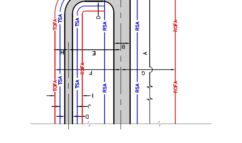
8 Exhibit 5-1 ARC Dimensional Standards 74
9 5.4.2 Runway and Taxiway Separation FAA dimensional criteria require a minimum separation distance (centerline to centerline) between a runway and a parallel runway, parallel taxiway, or aircraft parking area. Separation requirements are based on two components: 1) Approach Visibility Minimums and 2) Facilities Expected to Be Served (or Approach Category). The recommended Approach Category at Kalispell City Airport is A & B. There are essentially two options for approach visibility minimums: Visual and Not Lower Than ¾ Statute Mile and Lower Than ¾ Statute Mile. Lower approach visibility minimums are better so it ideally separation standards should be protected that would allow for lower approach visibility minimums. At, approach visibility minimums are presently Visual. Because of development constraints limiting separation standards at the existing site, approach visibility minimums exceeding Visual and Not Lower than ¾ Statute Mile are not anticipated. However, alternative sites may have the potential to provide greater separation standards and meet the requirements for an approach procedure with minimums Lower than 3/4- Mile Visibility. For Aircraft Approach Categories A & B and approach minimums of Visual and Not Lower Than ¾ Statute Mile, FAA separation standards for ARC B-I (NESA) requires a separation of 225 feet and ARC B-II requires a separation of 240 feet. Increasing approach visibility minimums to Lower than ¾-Mile visibility would require a separation of 300 feet between the runway and parallel taxiway. Based on this criterion, the minimum required separation between runway and taxiway at is 240 feet (ultimate ARC B-II standards and Not Lower Than ¾ Statute Mile. However, alternatives should be evaluated and compared to accommodate the greater separation of 300 feet consistent with approach minimums of Lower Than ¾ Statute Mile. At, the current separation between Runway 13/31 and both parallel taxiways is only 130 feet and therefore does not meet the minimum requirements for any of these design standards Runway and Taxiway Safety Areas FAA dimensional criteria for a Runway Safety Area (RSA) requires a relatively flat area free of any obstructions at each end of and surrounding the runway. FAA criteria for ARC B-I RSA require a total width of 120 feet centered on the runway centerline, extending to a length of 240 feet beyond the runway end. Criteria for ARC B-II RSA require a total width of 150 feet centered on the runway centerline, extending to a length of 300 feet beyond the runway end. Although existing and historical aeronautical operations only warrant ARC B-I dimensional standards at this time, B-II standards are anticipated during the 20-year planning period and must be protected. Therefore, the required dimensional standard for the Runway Safety Area at is to ultimate ARC B-II standards, or an RSA width of 150 feet. The existing RSA dimensions for Runway 13/31 generally comply with the grading and obstruction criteria for ARC B-I standards. However, a portion of the RSA lies outside of airport property and is therefore not under the control of the airport. Approximately 10 feet of the RSA on the west side of Runway 31 lies off of airport property for a distance of approximately 1,430 feet. FAA dimensional criteria for a Taxiway Safety Area (TSA) require a relatively flat area free of any obstructions surrounding the taxiway. FAA criteria for ARC B-I TSA require a total width of 49 feet centered on the taxiway centerline. Criteria for ARC B-II TSA require a total width of 79 feet. Although existing and historical aeronautical operations only warrant ARC B-I dimensional standards at this time, B-II standards are anticipated during the 20-year planning period and must be protected. Therefore, the required dimensional standard for the Taxiway Safety Area at 75
10 is to ultimate ARC B-II standards, or a TSA width of 79 feet. The existing TSA dimensions for the west parallel taxiway currently meets the criteria for ARC B-I. The existing TSA dimensions for the east parallel taxiway generally comply with the grading and obstruction criteria for ARC B-I standards. However, a portion of the TSA lies outside of airport property and is therefore not under the control of the airport. Approximately 14 feet of the TSA on the east side of the parallel taxiway (on the Runway 31 end) lies off of airport property for a distance of approximately 1,260 feet Runway and Taxiway Object Free Areas FAA dimensional criteria for a Runway Object Free Area (ROFA) require an area on both sides of the runway to be free of objects, except those objects needed for navigational purposes. FAA criteria for ARC B-I (SAE) standards require a total width of 250 feet centered on the runway centerline, extending to a length of 240 feet beyond the runway end. B-I (NESA) standards require a width of 400 feet, extending to a length of 240 feet beyond the runway end. B-II standards require a width of 500 feet, extending to a length of 300 feet beyond the runway end. Although existing and historical aeronautical operations only warrant ARC B-I dimensional standards at this time, B-II standards are anticipated during the 20-year planning period and must be protected. Therefore, the required dimensional standard for the Runway Object Free Area at is to ultimate ARC B-II standards, or an ROFA width of 500 feet. The existing ROFA dimensions for Runway 13/31 generally comply with the grading and obstruction criteria for ARC B-I standards. However, a portion of the ROFA lies outside of airport property and is therefore not under the control of the airport. Approximately 75 feet of the RSA on the west side of Runway 31 lies off of airport property for a distance of approximately 1,430 feet. FAA dimensional criteria for a Taxiway Object Free Area (TOFA) require an area on both sides of the taxiway to be free of objects, except those objects needed for navigational purposes. FAA criteria for ARC B-I TOFA require a total width of 79 feet centered on the taxiway centerline. Criteria for ARC B-II TOFA require a total width of 115 feet. Although existing and historical aeronautical operations only warrant ARC B-I dimensional standards at this time, B-II standards are anticipated during the 20-year planning period and must be protected. Therefore, the required dimensional standard for the Taxiway Object Free Area at is to ultimate ARC B-II standards, or an TOFA width of 115 feet. The existing TOFA dimensions for the west parallel taxiway currently meet the criteria for ARC B-I standards. The existing TOFA dimensions for the east parallel taxiway generally comply with the grading and obstruction criteria for ARC B-I standards. However, a portion of the TOFA lies outside of airport property and is therefore not under the control of the airport. Approximately 29 feet of the TOFA on the east side of the parallel taxiway (on the Runway 31 end) lies off of airport property for a distance of approximately 1,260 feet Runway Protection Zones FAA criteria for a Runway Protection Zone (RPZ) require an area clear of all objects such as buildings, roads, and any places of public assembly. The RPZ is trapezoidal in shape and centered about the extended end of the runway. RPZ dimensional requirements are based on two components: 1) Approach Visibility Minimums and 2) Facilities Expected to Be Served (or Approach Category). Facilities to be served are presently Small Aircraft Exclusively but should be increased to protect for Aircraft Approach Categories A & B. There are essentially three options for approach visibility minimums: Visual and Not Lower Than 1-Mile, Not Lower 76
11 Than ¾-Mile, and Lower Than ¾ Statute Mile. Lower approach visibility minimums are better so ideally separation standards should be protected that would allow for lower approach visibility minimums. At, approach visibility minimums are presently Visual. Because of development constraints at the existing site, approach visibility minimums exceeding Not Lower than 1-Mile are not anticipated. However, alternative sites would not be as confined and could therefore allow for development of facilities meeting the requirements for an approach procedure with minimums Not Lower than 3/4-Mile Visibility. Dimensional standards for RPZs are summarized in Table 5-4. RPZ dimensions to serve Small Aircraft Exclusively with approach visibility minimums of Visual and Not lower than 1-mile is 250 feet (inner end) by 450 feet (outer end) by 1,000 feet (length). To serve aircraft in Approach Categories A and B these dimensions increase to 500 feet (inner end) by 700 feet (outer end) by 1,000 feet (length); and for approach visibility minimums down to Not Lower than ¾-Mile, the RPZ dimensions increase to 1,000 feet (inner end) by 1,510 feet (outer end) by 1,700 feet (length). Based on this criterion, the required RPZ dimensions at are 500 feet by 700 feet by 1,000 feet (Approach Category A & B and Not Lower Than 1- Mile ). However, alternatives should be evaluated and compared to accommodate the greater RPZ dimensions consistent with approach minimums of Lower Than ¾-Mile. The RPZ s for Runway 13/31 currently do not meet the minimum design standards for Small Aircraft Exclusively with Visual and Not Lower than 1-Mile approach visibility minimums. The Runway 13 RPZ falls outside of airport property and encompasses a segment of Airport Road and 18 th Street E as well as portions of several privately owned properties including a couple of homes. The Runway 31 RPZ falls almost entirely off of airport property and encompasses a segment of private dirt road as well as portions of several privately owned properties. The periphery of the Runway 31 RPZ extends out to several privately owned buildings. Table 5-4 FAA Dimensions for Runway Protection Zones (a) (Visual and Not Lower than 1-Mile) 1 Small Aircraft Exclusively Approach Categories A and B RPZ Dim. Key(b) Inner Width W1 Outer Width W2 Length 1,000 1,000 L a Airport Design, FAA Circular 150/ b Reference Dimension Key to Exhibit 5-1. The primary issue with the RPZ s at is the ownership and control of the property by the airport. Current FAA practice is to require the acquisition of RPZ s in fee ownership although easements may be allowed on a case by case basis. To meet FAA requirements for RPZ s, land would need to be acquired for both runway ends to obtain the necessary ownership and control for the entire RPZ area. Within the RPZ, existing buildings and structures would need to be removed. While it is desirable to clear all objects from the RPZ, some uses such as roads are occasionally permitted, provided they are outside of the ROFA. In the case of Kalispell City Airport, there are several roads that cross through the RPZ s but fall outside of the ROFA. Airport Road and 18 th Street E are problematic however. Both roads are Arterial Routes with heavy traffic and would therefore not be allowed within the Runway 13 RPZ. The roads would either need to be relocated or the Runway threshold would need to be displaced to rectify this issue. 77
12 5.4.6 Conclusions and Recommendations There are several deficiencies with the existing airport facilities meeting even the minimum FAA design requirements for ARC B-I (SAE) standards. Most of these issues are the direct result of inadequate property ownership for the required safety areas, object free areas, and RPZ s. In addition, neither of the parallel taxiways meet the minimum B-I requirements for width and runway separation. To meet minimum B-I design requirements, the following improvements are required: Acquire property interest and remove obstructions for a 250 feet x 450 feet x 1,000 feet Runway 13 RPZ; Acquire property interest and remove obstructions for a 250 feet x 450 feet x 1,000 feet Runway 31 RPZ; Increase separation between runway and parallel taxiways from 130 feet to 150 feet; Widen taxiways from 20 feet to 25 feet; Acquire property needed for 250 foot wide Runway 31 OFA; It should be noted that the FAA will not support federal funding for development that is restricted to Small Aircraft Exclusively (ie ARC B-I (SAE) ). is a public use airport that does not restrict usage to aircraft weighing less than 12,500 pounds SWG. The minimum facility requirements the FAA would support federal funding on would be to protect for ARC B-II standards while possibly allowing for interim development of facilities meeting ARC B-I (NESA). Upgrading to ultimate ARC B-II standards will impact all of the existing airside facilities with the exception of the new taxilanes and apron areas located on the west side of the airport. To meet B-II design requirements, the following improvements are required: Acquire property interest and remove obstructions for a 500 feet x 700 feet x 1,000 feet Runway 13 RPZ; Acquire property interest and remove obstructions for a 500 feet x 700 feet x 1,000 feet Runway 31 RPZ; Increase separation between runway and parallel taxiways from 130 feet to 240 feet; Widen Runway 13/31 from 60 feet to 75 feet; Widen taxiways from 20 feet to 35 feet; Acquire property needed for a 500 foot wide Runway 31 OFA; Acquire property needed for a 131 feet wide taxiway OFA. 5.5 Runway Length Requirements The required runway length for an airport takes into account the take-off and landing performance of the most critical aircraft expected to make regular use of the airport. Runway length is a function of airport elevation, mean maximum temperature of the hottest month, aircraft take-off weight, aircraft engine performance, runway gradient, etc. All of these variables affect the lift of the aircraft on departure. Prior FAA design guidance for runway length provided for recommended runway lengths that would accommodate 75 percent, 95 percent, and 100 percent of the small airplane fleet. Current FAA guidance (Chapter 2 of AC 150/5325-4B) allows for runway length recommendations for 95 percent and 100 percent of the small airplane fleet; the 75 percent length provision is no longer 78
13 provided. The recommended runway length for Runway 13/31 is determined in accordance with Chapter 2 of AC 150/5325-4B which provides Runway lengths for Small Airplanes with Maximum Certificated Takeoff Weight of 12,500 Pounds (5,670 kg) or Less. This design concept requires grouping of aircraft using the airport by aircraft approach speed. The highest approach speed group is then divided on the basis of passenger capacity into airplanes having fewer than 10 passenger seats and airplanes having more than 10 passenger seats. The less than 10 passenger seat category is then further based on two percentages of fleet: 95 percent of the fleet and 100 percent of the fleet. For, the critical aircraft are twin-engine airplanes with a takeoff weight less than 12,500 pounds (utility or small aircraft), approach speeds between 91 knots and 120 knots (Aircraft Approach Category B), and wing spans less than 49 feet (Design Group I). Two figures are provided in Chapter 2 of AC 150/5325-4B that allow for the determination of recommended runway length. The only information required for this design basis is the average high temperature for the hottest month of the year and the airport elevation. For Kalispell City Airport the recommended runway length was determined from the field elevation of feet above mean sea level and the mean daily maximum temperatures of 81.6 degrees for the hottest month of the year. Utilizing this information in conjunction with Figures 2-1 and 2-2 results in the recommended runway lengths summarized in Table 5-5. The existing 3,600-foot by 60-foot paved Runway 13/31 does not meet the minimum recommended length to accommodate 95 percent of small aircraft fleet with 10 or less passengers. The runway would need to be lengthened by 600 feet to 4,200 feet to the minimum recommended runway length requirements at the existing site. Based on comments from the pilot s survey, questions regarding runway length generated mixed responses. One question reported that 69 percent of the respondents felt the runway length was at least adequate. In contrast, 66 percent of the respondents thought that it was at least important to extend the runway. Developing any conclusions from this can be risky. Most of the pilots that responded to the questionnaire are predominantly flying small aircraft. Runway length would not be a factor at all with this group of pilots. A better indicator would be to question pilots of larger and faster aircraft whether they would use the runway if it were lengthened. However, an effort to target this group of potential users would be difficult, at best. In addition, public comment from regular users of the airport suggests that the current runway length is adequate for the present type of aircraft frequently operating at the airport. Again, most of these pilots are flying small aircraft and there comments may not be representative of other pilots who may be deterred from using the airport because of the facilities. With Glacier Park International Airport only a eight miles away, there is a local airport with facilities sufficient to accommodate high performance aircraft. Lengthening of the runway has been planned for several years to the south, off of the end of Runway 31. The current approved ALP depicts staged runway development with successive lengths of 3,700 feet (75 percent of fleet), 4,200 feet (95 percent of fleet), and 4,700 feet (100 percent of fleet). In order to accommodate the runway extension which would lengthen the runway to an ultimate length of 4,700 feet and allow for expansion to Design Group II dimensional standards, the existing runway alignment must be shifted to the south and west and the orientation must be rotated approximately 4 degrees clockwise. It is not feasible to extend Runway 13 to the north however. There are significant development constraints to north including multiple residences, businesses, and two arterial roadways. 79

 4,700 Ft. Small airplanes with 10 or more passengers (Typical of King Air E90) 4,580 Ft.")

14 Table 5-5 Runway Length Recommendations for Small Airplanes Weighing Less than 12,500 Pounds Airport and Runway Data Airport Elevation Feet Mean Maximum Temperature of the hottest month 81.6 Critical Design Aircraft Approach Speed Knots Maximum Certificated Takeoff Weight 12,500 Pounds Runway Lengths Recommended For Airport Design Small airplanes with approach speeds of less than 30 knots Small airplanes with approach speeds of less than 50 knots Small airplanes with less than 10 passenger seats: 95 percent of Fleet (Typical of Cessna 340) 388 Ft. 1,035 Ft. 4,200 Ft. Small airplanes with less than 10 passenger seats: 100 percent of Fleet (Typical of Cessna 340) 4,700 Ft. Small airplanes with 10 or more passengers (Typical of King Air E90) 4,580 Ft. Large airplanes greater than 12,500 pounds but less than 60,000 pounds (Typical of Dassault Falcon 20) 5,400 Ft. a FAA AC 150/5325-4B, Runway Length Requirements for Airport Design Figure 2-1 and 2-2 Under the proposed plan to shift the Runway 32 threshold further to the south as shown on the current ALP, there would be some immediate improvements to nuisance noise around the airport and aeronautical safety. Aircraft making a Runway 32 departure will now be starting their takeoff approximately 1,550 feet further south. This will allow departing aircraft to gain more altitude before transitioning from above airport property to above residential property. In a Cessna 172 (721 ft/min rate of climb), the relocated threshold would allow the aircraft to be approximately 170 feet higher than it would have been departing from the existing Runway 31 threshold. Not only will the additional altitude improve the level of noise heard on the ground, but there will be benefits to safety 80
15 also. Every foot of additional altitude that an aircraft has provides additional time and options to pilot in an event of an emergency. Additional time may mean the difference in finding, and making it to a safe place to land the aircraft or even making a return to the airport for a landing on airport property. The additional runway length also provides a greater safety margin for aborting takeoffs in either direction. Based on current and forecast aeronautical operations and the FAA s current guidance on runway length, the minimum recommended runway length to accommodate 95 percent of small airplanes with less than 10 passenger seats at is 4,200 feet; a 600 foot increase in length from the existing runway. The need to lengthen the runway to 4,700 feet to accommodate 100 percent of small airplanes is not supported at this time or anticipated during the 20-year planning period. However, runway length may become an issue if the airport is frequented by higher performance aircraft in the future, especially if unanticipated use is the result of the airport being upgraded to ARC B-II standards. Additionally, there has been outspoken public opposition to extending the runway. The general belief of this opposition is that a longer runway will attract larger and higher performance aircraft thereby increasing noise and decreasing safety. Of most concern is a general belief that a longer runway will attract larger, high performance business jets. Exhibit 5-2 on the following page is a graphical depiction of several common general aviation aircraft ranging from the single-engine Cessna 172 Sky Hawk to the large jet Cessna Citation X. The chart graphically depicts the minimum length of runway recommended for the safe operation of these aircraft. Runway length requirements have been determined for the field elevation and temperature requirements specified in Table 5-5 for the. Current and proposed runway lengths have also been added to the figure to show which types of aircraft could safely operate at this facility under these conditions. This figure clearly shows that most jet aircraft require significantly greater runway length than what would be available at to safely operate during the warmer summer months. Use by the King Air 200, needing 4,400 feet of runway, would even be questionable on a warm summer day. Based on this evaluation, the recommended 4,200 foot long runway would not likely attract these larger, faster aircraft. These pilots would likely still continue to use Glacier Park International Airport. In comparison, GPI s airside facilities are much more suitable for higher performance aircraft. Runway 02/20 is 150 feet wide and 9,000 feet long meeting ARC C-III standards; there is part time (0800 to 0000) Air Traffic Control; Automated Surface Observation System (weather); and a precision instrument approach for Runway 02. In conclusion, there does not appear to be a perceived need, based on current use, to extend the existing runway beyond its current 3,600 feet length. However, the forecasted aeronautical operations and the FAA s current guidance on runway length strongly encourage a recommendation at for initial development of a runway length of 4,200 feet to accommodate 95 percent of small airplanes with less than 10 passenger seats and an ultimate length of 4,700 feet to accommodate 100 percent of small airplanes. This will require that the City acquire all of the land required for the airside facilities which meet the minimum recommended runway length of 4,200 feet for 95 percent of the small airplane fleet (less than 10 passengers). The City will also be required to depict an ultimate runway extension to 4,700 feet for 100 percent of the small airplane fleet (less than 10 passengers) on its Airport Layout Plan with the necessary land requirements. A staged approach to runway length would require that the City periodically re-evaluate the critical aircraft using the airport and plan for a future runway extension accordingly. 81


 Approach Type and 2) Runway Type.")
16 Exhibit 5-2 Typical Aircraft Runway Length Requirements Cessna 172 Cessna 340 2,095 3,120 Ex. Runway = 3,600' Fut. Runway = 4,200' Ult. Runway = 4,700' King Air 200 4,400 Cessna Citation X 5,090 Gulfstream G-111 5,500 Cessna Citation 560 5, ,000 2,000 3,000 4,000 5,000 6,000 Runway Length Notes: 1. All lengths based on field elevation of 2,950 MSL and 81.6º F. 2. Cessna 172/340 length represents runway length to clear a 50 obstacle at maximum takeoff weight. 3. Lengths for King Air 200, Cessna Citation X, Gulfstream G-111, and Cessna 560 are declared distances (length to accelerate to V1 and then come to a complete stop). 5.6 Airspace Limitations The FAA has established standards for determining obstructions to airports in Part 77 of the Federal Aviation Regulations. These standards establish the civil imaginary surfaces surrounding an airport. Objects that extend above these surfaces are considered obstructions and should be removed or marked and lighted, depending on the nature of the obstruction and the feasibility of its removal. These Criteria for Airport Imaginary Surfaces for Determining Obstructions are presented in Table 5-6 and depicted in Exhibit 5-3. Identification of Part 77 surface requirements are established from two components: 1) Approach Type and 2) Runway Type. Approach Types include Visual, Non-Precision Instrument with Visibility Minimums Greater than ¾ Mile, Non-Precision Instrument with Visibility Minimums as Low as ¾ Mile, and Precision Instrument. Runway Types include Utility Runways and Runways Larger than Utility. A Utility Runway is one that is constructed for and intended to be used by propeller driven aircraft of 12,500 pounds maximum gross weight and less. 82
17 Dimension Table 5-6 Criteria for Airport t Imaginary Surfaces for Determining Obstructions (a) Dimensional Standards, ft (see Exhibit 5-3) 5 Visual Runway Non-Precision Instrument Runway Runways Larger Runways than Utility Utility Utility larger than Visibility Visibility Runways runways utility minimums minimums greater than as low as 3/4 mi 3/4 mi Precision Instrument Runway A ,000 1,000 B 5,000 5,000 5,000 10,000 10,000 10,000 C 1,250 1,500 2,000 3,500 4,000 16,000 D 5,000 5,000 5,000 10,000 10,000 * E 20:1 20:1 20:1 34:1 34:1 * (a) Federal Aviation Regulations, Part 77. A = Width of primary surface and width of approach surface at inner end B = Radius of horizontal surface C = Approach surface width at end D = Approach surface length E = Approach slope * = Precision Instrument Approach slope is 50:1 for inner 10,000 feet and 40:1 for an additional 40,000 feet Although the is presently a Visual and Utility runway, the City should plan for the implementation of a non-precision instrument approach procedure and protect the airspace consistent with better minimums and larger aircraft. This approach is consistent with the current, approved ALP and the Airport Affected Area Regulations adopted by the City. Although the forecasts do not show substantial use by larger than utility aircraft, the should protect Part 77 Airspace for a Larger Than Utility runway and a Non-Precision Instrument approach with approach visibility minimums Greater Than ¾-Mile. Specific obstructions or penetrations into the Part 77 imaginary surfaces will be evaluated for each of the alternatives presented in Chapter Primary Surface The primary surface is a surface longitudinally centered on the runway and extends 200 feet beyond each end of the runway. The existing primary surface at is 250 feet in total width, meeting the minimum requirements for a Visual, Utility Runway. There are no documented obstructions to the primary surface. The recommended width for the Primary Surface at is 500 feet ( Runways Larger Than Utility and Visibility Minimums Greater than ¾-Mile ). Increasing the primary surface requirements to Utility, Non-precision Instrument Runway or Larger than Utility Runway is not feasible without shifting the runway to the west. On its existing alignment, the 500 foot primary surface would extend into several of the businesses fronting U.S. Highway
18 Figure 5-3 Civil Airport Imaginary Surfaces 84
19 5.6.2 Approach Surfaces Approach surfaces extend outward from the primary surface at each end of the runway. The approach slope for a Visual Runway (Utility and Larger than Utility and a Utility, Non-Precision Instrument Runway is 20:1. A 20:1 approach means that for every 20 feet measured outward (horizontally), the approach surface slopes upward (vertically) one foot. The approach slope for a Larger than Utility, Non-Precision Instrument Runway is 34:1. Approach surface sizes also vary according to aircraft weight and approach type and minimums. These different requirements are described as follows: The approach surface for a Utility, Visible Runway expands outward from an inner width of 250 feet to an outer width of 1,250 feet over a distance of 5,000 feet. The approach surface for a Visible, Larger than Utility Runway expands outward from an inner width of 500 feet to an outer width of 1,500 feet over a distance of 5,000 feet. The approach surface for a Utility, Non-precision Instrument Runway expands from 500 feet to 2,000 feet over its length of 5,000 feet. The approach surface for a Larger than Utility, Non-precision Instrument Runway with Visibility Minimums Greater than ¾-mile expands from 500 feet to 3,500 feet over its length of 10,000 feet. The recommended requirements for the Approach Surface at is the 500 feet to 3,500 feet over a length of 10,000 feet at a 34:1 Slope ( Runways Larger Than Utility and Visibility Minimums Greater than ¾-Mile ). The City of Kalispell has adopted Airport Affected Area Regulations (Appendix B) to protect the airspace associated with the. In accordance with these regulations, no obstructions are authorized in the approach surfaces, transitional surfaces, horizontal surfaces, and conical surfaces. The regulations allow the City of Kalispell to review and permit construction proposals within the airport affected area and require the removal of non-conforming uses which are not grandfathered in Runway 13 Approach The existing Runway 13 approach surface is clear of 20:1 obstructions and meets requirements for a Utility, Visible Runway. However, two (2) of the light poles at Legends Field penetrate into the 34:1 approach surface of the larger than utility, non-precision instrument runway. With the Runway 13 threshold left in its current location, the light poles would penetrate the 34:1 approach surface by approximately 35 feet. There is also the possibility that the Runway 13 approach would have a potential conflict with the precision approach to Glacier Park International Airport. A straight in approach to Runway 13 would intersect the precision approach to Runway 2 at GPI although there would be a significant amount of elevation difference between the two approaches. The Runway 2 approach at GPI is approximately 6000 mean sea level (MSL) and the Runway 13 approach at KCA is approximately 4000 feet MSL, a difference of 2000 feet at the point of intersection. The airspace associated with both of these approaches will be evaluated as part of the airspace action that will be performed on the preferred alternative. 85
FACILITY REQUIREMENTS SUMMARY OF KEY ISSUES OVERVIEW
 FACILITY REQUIREMENTS SUMMARY OF KEY ISSUES OVERVIEW This summary is intended to provide a brief overview of the key issues associated with conformance to FAA standards at Methow Valley State Airport.
CHAPTER 3 ALTERNATIVES CONSIDERED
 CHAPTER 3 ALTERNATIVES CONSIDERED 3.0 ALTERNATIVES The 2010 Stevensville Airport Master Plan contained five (5) airside development options designed to meet projected demands. Each of the options from
CHAPTER 1 BACKGROUND AND PROPOSED ACTION
 CHAPTER 1 BACKGROUND AND PROPOSED ACTION 1.0 INTRODUCTION An Environmental Assessment (EA) evaluates the effects of a proposed Federal action on the surrounding environment and is prepared in compliance
AIRSIDE CAPACITY AND FACILITY REQUIREMENTS
 AIRSIDE CAPACITY AND FACILITY REQUIREMENTS This Section investigates the capacity of the airport, its ability to meet current demand, and the facilities required to meet forecasted needs as established
Source: Chippewa Valley Regional Airport ASOS, Period of Record
 Chapter 1 Inventory Runway wind coverage is the percentage of time a runway can be used without exceeding allowable crosswind velocities. Allowable crosswind velocities vary depending on aircraft size
Chapter 4 Airport Facility Requirements
 Chapter 4 Airport Facility Requirements Introduction CHAPTER 4 AIRPORT FACILITY REQUIREMENTS MAY 2013-1 Organization of Materials CHAPTER 4 AIRPORT FACILITY REQUIREMENTS MAY 2013-2 RPZ - ROAD RPZ - NON-AIRPORT
Agenda: SASP SAC Meeting 3
 Agenda: SASP SAC Meeting 3 Date: 04/12/18 Public Involvement Plan Update Defining the System Recommended Classifications Discussion Break Review current system Outreach what we heard Proposed changes Classification
Chapter Six ALP Drawings. Tacoma Narrows Airport. Master Plan Update
 Chapter Six ALP Drawings Master Plan Update The master planning process for the (Airport) has evolved through efforts in the previous chapters to analyze future aviation demand, establish airside and landside
DRAFT MASTER PLAN UPDATE
 DRAFT MASTER PLAN UPDATE CHAPTER VI: AIRPORT LAYOUT PLAN NARRATIVE DRAFT REPORT APRIL 2017 PREPARED BY: Table of Contents WESTCHESTER COUNTY AIRPORT 6 AIRPORT LAYOUT PLAN NARRATIVE REPORT... 6-1 6.1 AGIS
Appendix C AIRPORT LAYOUT PLANS
 Appendix C AIRPORT LAYOUT PLANS Appendix C AIRPORT LAYOUT PLANS Airport Master Plan Santa Barbara Airport As part of this Airport Master Plan, the Federal Aviation Administration (FAA) requires the development
Airfield Design. Public Review Draft OVERVIEW BASIC DESIGN FACTORS. Airport Role
 Public Review Draft 3 Airfield Design OVERVIEW The Facilities Plan, Figure 3D, presents the recommended airfield improvements. The principal airfield design issues examined in this chapter are the optimal
Runway Length Analysis Prescott Municipal Airport
 APPENDIX 2 Runway Length Analysis Prescott Municipal Airport May 11, 2009 Version 2 (draft) Table of Contents Introduction... 1-1 Section 1 Purpose & Need... 1-2 Section 2 Design Standards...1-3 Section
Preliminary Findings of Proposed Alternative
 Preliminary Findings of Proposed Alternative The attached drawing provides a schematic layout of the proposed alternative that will be discussed on July 27, 2010. A full report will follow and should be
1 DRAFT. General Aviation Terminal Services Aircraft Hangars Aircraft Parking Aprons Airport Support Facilities
 To properly plan for improvements at Dallas Executive Airport, it is necessary to translate forecast aviation demand into the specific types and quantities of facilities that can adequately serve the demand.
CATCODE ] CATCODE
![CATCODE ] CATCODE](/thumbs/82/85644630.jpg "CATCODE ] CATCODE") Runways. FAC: 1111 CATCODE: 111111 OPR: AFCEC/COS OCR: AF/A3O-A 1.1. Description. The runway is the paved surface provided for normal aircraft landings and take offs. Runways are classified as either Class
Runways. FAC: 1111 CATCODE: 111111 OPR: AFCEC/COS OCR: AF/A3O-A 1.1. Description. The runway is the paved surface provided for normal aircraft landings and take offs. Runways are classified as either Class
CHAPTER 1 EXECUTIVE SUMMARY
 CHAPTER 1 EXECUTIVE SUMMARY 1 1 EXECUTIVE SUMMARY INTRODUCTION William R. Fairchild International Airport (CLM) is located approximately three miles west of the city of Port Angeles, Washington. The airport
OVERVIEW BASIC DESIGN FACTORS. Demand Determinants
 3 Airfield Airfield Design Design OVERVIEW The basic configuration of the runway and taxiway system at Hanford Municipal Airport has changed moderately since the airport was constructed in 1950. These
The following criteria shall be applied within the boundaries of the AO District:
 Sec. 419 (a) Purpose AIRPORT OVERLAY DISTRICT (AO) The purpose of the Airport Overlay District is to regulate and restrict the height of structures, objects, or natural growth, regulate the locations of
CHAPTER 3 AIRPORT FACILITY REQUIREMENTS
 CHAPTER 3 AIRPORT FACILITY REQUIREMENTS 3.1 Introduction The existing runway and taxiway system at Skyhaven Airport provides more than adequate operational capacity to accommodate future peak hour and
MASTER PLAN CONCEPT 1 DRAFT
 The Airport Master Plan Update for Dallas Executive Airport has included the development of aviation demand forecasts, an assessment of future facility needs, and the evaluation of airport development
The purpose of this Demand/Capacity. The airfield configuration for SPG. Methods for determining airport AIRPORT DEMAND CAPACITY. Runway Configuration
 Chapter 4 Page 65 AIRPORT DEMAND CAPACITY The purpose of this Demand/Capacity Analysis is to examine the capability of the Albert Whitted Airport (SPG) to meet the needs of its users. In doing so, this
Hartford-Brainard Airport Potential Runway Closure White Paper
 Hartford-Brainard Airport Potential Runway 11-29 Closure White Paper June 2012 In recent years there has been discussion regarding the necessity of Runway 11-29 to the Hartford- Brainard Airport (HFD)
According to FAA Advisory Circular 150/5060-5, Airport Capacity and Delay, the elements that affect airfield capacity include:
 4.1 INTRODUCTION The previous chapters have described the existing facilities and provided planning guidelines as well as a forecast of demand for aviation activity at North Perry Airport. The demand/capacity
Consideration will be given to other methods of compliance which may be presented to the Authority.
 Advisory Circular AC 139-10 Revision 1 Control of Obstacles 27 April 2007 General Civil Aviation Authority advisory circulars (AC) contain information about standards, practices and procedures that the
Airport Obstruction Standards
 Airport Obstruction Standards Dr. Antonio Trani Department of Civil and Environmental Engineering Virginia Tech Outline of this Presentation Obstructions to navigation around airports Discussion of Federal
APPENDIX X: RUNWAY LENGTH ANALYSIS
 APPENDIX X: RUNWAY LENGTH ANALYSIS Purpose For this Airport Master Plan study, the FAA has requested a runway length analysis to be completed to current FAA AC 150/5325-4B, Runway Length Requirements for
4.0 AIRFIELD CAPACITY & FACILITY REQUIREMENTS
 4.0 AIRFIELD CAPACITY & FACILITY REQUIREMENTS A key step in the Airport Master Plan (AMP) process is determining future requirements for airport facilities that will allow for airside and landside development
chapter 5 Recommended Master Plan Concept airport master plan MASTER PLAN CONCEPT
 chapter 5 Recommended Master Plan Concept airport master plan The planning process for Coolidge Municipal Airport has included several analytical efforts in the previous chapters intended to project potential
1.1.3 Taxiways. Figure 1-15: Taxiway Data. DRAFT Inventory TYPICAL PAVEMENT CROSS-SECTION LIGHTING TYPE LENGTH (FEET) WIDTH (FEET) LIGHTING CONDITION
 WIDTH (FEET) LIGHTING CONDITION") 1.1.3 Taxiways EWN has an extensive network of taxiways and taxilanes connecting the terminal, air cargo, and general aviation areas with the runways as listed in Figure 1-15. A 50-foot wide parallel taxiway
1.1.3 Taxiways EWN has an extensive network of taxiways and taxilanes connecting the terminal, air cargo, and general aviation areas with the runways as listed in Figure 1-15. A 50-foot wide parallel taxiway
C > Capacity Analysis and Facility Requirements
 Buchanan Field Buchanan Field Airport Master Planning Program C. CAPACITY ANALYSIS & FACILITY REQUIREMENTS C > Capacity Analysis and Facility Requirements INTRODUCTION. The capacity of an airfield is primarily
5. Facility Requirements
 5. Facility Requirements The purpose of this chapter is to compare existing airfield and adjacent landside facilities with the Airport operations and aircraft forecasts developed in the previous chapter
CHAPTER D Capacity Analysis and Facility Requirements INTRODUCTION
 CHAPTER D Capacity Analysis and Facility Requirements INTRODUCTION The capacity of an airfield is primarily a function of the major aircraft operating surfaces that compose the facility and the configuration
Table of Contents. List of Tables. Cincinnati/Northern Kentucky International Airport 2035 Master Plan Update
 Table of Contents 7.1. Airport Layout Plan (Existing Conditions)... 2 7.2. Airport Layout Plan (Future Conditions)... 3 7.3. Technical Data Sheet... 5 7.4. Commercial Terminal Area Drawing... 5 7.5. East
DEPARTMENT: CIVIL ENGINEERING SEMESTER: III SUBJECT CODE / Name: CE2303/ Railway, Airport and Harbors Engineering 2 MARK QUESTIONS AND ANSWERS
 DEPARTMENT: CIVIL ENGINEERING SEMESTER: III SUBJECT CODE / Name: CE2303/ Railway, Airport and Harbors Engineering 2 MARK QUESTIONS AND ANSWERS 1.Define wind Coverage (AUC NOV/DEC 2010),(AUC NOV/DEC 2011)
New Opportunities PUBLIC WORKSHOP. Venice Municipal. Bringing g the pieces together
 Bringing g the PUBLIC WORKSHOP Venice Municipal Airport New Opportunities Presented for Venice City Council & Citizens of Venice September 25, 2009 Slide 1 Bringing g the Welcome & Introductions May 12th
Chapter 9 - AIRPORT SYSTEM DESIGN
 Chapter 9 - AIRPORT SYSTEM DESIGN 9.01 GENERAL This chapter discusses the development program for Dutchess County Airport to the year 2020. This airport system design is based upon the airport's existing
AERONAUTICAL SURVEYS & INSTRUMENT FLIGHT PROCEDURES
 AERONAUTICAL SURVEYS & INSTRUMENT FLIGHT PROCEDURES Current as of November 2012 ALASKA AVIATION SYSTEM PLAN UPDATE Prepared for: State of Alaska Department of Transportation & Public Facilities Division
Lopez Island Airport Master Plan Update. Public Meeting June 15, 2017
 Lopez Island Airport Master Plan Update Public Meeting June 15, 2017 Master Plan Update Team Reid Middleton/Everett, WA Shannon Kinsella, Project Manager Melania Haagsma, Project Engineer Mead & Hunt/Tulsa,
Executive Summary. MASTER PLAN UPDATE Fort Collins-Loveland Municipal Airport
 Executive Summary MASTER PLAN UPDATE Fort Collins-Loveland Municipal Airport As a general aviation and commercial service airport, Fort Collins- Loveland Municipal Airport serves as an important niche
3 INTRODUCTION. Chapter Three Facility Requirements. Facility Requirements PEAKING CHARACTERISTICS
 Chapter Three Facility Requirements 3 INTRODUCTION This chapter identifies the long-range airfield and terminal area facilities needed to satisfy the 20-year forecast of aviation demand at Monett Municipal
Addendum - Airport Development Alternatives (Chapter 6)
") Bowers Field Addendum - Airport Development Alternatives (Chapter 6) This addendum to the Airport Development Alternatives chapter includes the preferred airside development alternative and the preliminary
Bowers Field Addendum - Airport Development Alternatives (Chapter 6) This addendum to the Airport Development Alternatives chapter includes the preferred airside development alternative and the preliminary
PLU Airport Master Plan. Master Plan Advisory Committee (MPAC) Meeting #4 March 19, 2018
 Meeting #4 March 19, 2018") PLU Airport Master Plan Master Plan Advisory Committee (MPAC) Meeting #4 March 19, 2018 Meeting Agenda 1. Master Plan Status [5 Minutes] 2. Preferred Forecasts [15 Minutes] 3. Runway Length Options [45
PLU Airport Master Plan Master Plan Advisory Committee (MPAC) Meeting #4 March 19, 2018 Meeting Agenda 1. Master Plan Status [5 Minutes] 2. Preferred Forecasts [15 Minutes] 3. Runway Length Options [45
Tallahassee International Airport Master Plan. Technical Advisory Committee Meeting #2 October 19, 2016
 Tallahassee International Airport Master Plan Technical Advisory Committee Meeting #2 October 19, 2016 Agenda Welcome / Introductions Master Plan Process and Project Status Forecast of Aviation Demand
Facility Requirements
 C H A P T E R T H R E E Facility Requirements 3.0 OVERVIEW Airport planning for facility requirements is based upon addressing any existing issues and accommodating the probable demand that may occur over
Chapter 4.0 Facility Requirements
 Chapter 4.0 Facility Requirements Having inventoried the existing infrastructure and forecasted demand, determining airport facility requirements is the next essential step in the airport master planning
15 Precision Approach Path Indicator 33 None RSA 150 feet wide by 300 feet long 150 feet wide by 300 feet long
 The first (AMP) was completed in 1984 and updated in 2000. The current FAA approved Airport Layout Plan (ALP) is dated November 9, 2001. The FAA suggests updating the AMP every five year in accordance
APPENDIX D FEDERAL AVIATION REGULATIONS, PART 77
 APPENDIX D FEDERAL AVIATION REGULATIONS, PART 77 Subparts A through C PART 77 - OBJECTS AFFECTING NAVIGABLE AIRSPACE Subpart A General 77.1 Scope. 77.2 Definition of terms. 77.3 Standards. 77.5 Kinds of
ORDINANCE NO. _2013-
 ORDINANCE NO. _2013- AN ORDINANCE OF THE TOWNSHIP OF CONEWAGO, DAUPHIN COUNTY, PENNSYLVANIA, PROVIDING FOR AIRPORT ZONING REGULATIONS WITHIN THE AIRPORT ZONING OVERLAY DISTRICT CREATED BY THIS ORDINANCE
PORT OF PORTLAND. Chapter Four AVIATION FACILITY REQUIREMENTS
 PORT OF PORTLAND Chapter Four AVIATION FACILITY REQUIREMENTS CHAPTER FOUR PORT OF PORTLAND AVIATION FACILITY REQUIREMENTS In this chapter, existing components of the airport are evaluated to identify the
Chapter 4 Airport Capacity Assessment and Identification of Facility Needs
 Chapter 4 Airport Capacity Assessment and Identification of Facility Needs 4.1 Introduction The purpose of the airport capacity assessment and identification of facility needs is to evaluate the single
Basic Design Factors. Airfield Design. Airport Role
 Chapter 3 Airfield Design Basic Design Factors The Federal Aviation Administration (FAA) provides guidance and standards for airport design through a series of Advisory Circulars (ACs). These guidelines
FINAL SUMMARY REPORT
 FINAL SUMMARY REPORT RUNWAY 1-19 EXTENSION ANALYSIS at MIDDLEBURY STATE AIRPORT PREPARED BY ROXBURY, VERMONT APRIL 2008 FINAL SUMMARY REPORT TABLE OF CONTENTS SECTION PAGE 1.1 INTRODUCTION...1 2.1 OBSTRUCTION
Appendix B Ultimate Airport Capacity and Delay Simulation Modeling Analysis
 Appendix B ULTIMATE AIRPORT CAPACITY & DELAY SIMULATION MODELING ANALYSIS B TABLE OF CONTENTS EXHIBITS TABLES B.1 Introduction... 1 B.2 Simulation Modeling Assumption and Methodology... 4 B.2.1 Runway
Chapter 4 Airport Facility Requirements
 Chapter 4 Airport Facility Requirements The evaluation of airport facility requirements uses the results of the inventory and forecasts contained in Chapters Two and Three, as well as established planning
Chapter Three AIRPORT FACILITY REQUIREMENTS/ALTERNATIVES
 Chapter Three AIRPORT FACILITY REQUIREMENTS/ALTERNATIVES Airport Layout Plan Report In this chapter, existing components of the Airport are evaluated so that the capacities of the overall system are identified.
Dr. Antonio A. Trani Professor of Civil Engineering Virginia Polytechnic Institute and State University. Spring 2015 Blacksburg, Virginia
 CEE 4674 Airport Planning and Design Runway Length Calculations Addendum 1 Dr. Antonio A. Trani Professor of Civil Engineering Virginia Polytechnic Institute and State University Spring 2015 Blacksburg,
Chapter 4 Airport Facility Requirements. Introduction
 Chapter 4 Airport Facility Requirements Introduction The airport facility requirements analysis combines the results of the inventory and forecasts contained in Chapters Two and Three, and the applicable
Chapter 4 AIRPORT DEVELOPMENT ALTERNATIVES
 Chapter 4 AIRPORT DEVELOPMENT ALTERNATIVES Chapter Four Airport Development Alternatives Prior to formulating a development program for Ryan Airfield, it is important to consider development potential
SITE ELEVATION AMSL...Ground Elevation in feet AMSL STRUCTURE HEIGHT...Height Above Ground Level OVERALL HEIGHT AMSL...Total Overall Height AMSL
 ******************************************** * Federal Airways & Airspace * * Summary Report * ******************************************** File: User Assigned File Name Latitude: NAD83 Coordinate Longitude:
CHAPTER FOUR AIRPORT ALTERNATIVES
 4.0 INTRODUCTION CHAPTER FOUR The goal of the master planning process is to provide the City of New Smyrna Beach with an assessment of the adequacy and capabilities of the Airport as well as to identify
AERODROME LICENCE APPLICATION PROCESS
 0000180111 Page 2 Why is a Licence Required? An aerodrome licence is required for a site if it is intended to facilitate operations by commercial transport aircraft, other aerial work other than rotorcraft,
TECHNICAL REPORT #7 Palm Beach International Airport Airport Layout Plan
 TECHNICAL REPORT #7 Palm Beach International Airport Airport Layout Plan Technical Report #7 Palm Beach International Airport Layout Plan Palm Beach International Airport Prepared for Palm Beach County
Draft Concept Alternatives Analysis for the Inaugural Airport Program September 2005
 Draft Concept Alternatives Analysis for the Inaugural Airport Program September 2005 Section 3 - Refinement of the Ultimate Airfield Concept Using the Base Concept identified in Section 2, IDOT re-examined
II. Purpose and Need. 2.1 Background
 II. 2.1 Background The Metropolitan Washington Airports Authority is preparing an Environmental Assessment of potential environmental impacts associated with proposed enhancements to the Runway 4-22 and
Chapter 5. Facility Requirements
 Chapter 5 Facility Requirements Chapter 5 Facility Requirements INTRODUCTION The Baseline Forecast was used to determine facility requirements. Chapter 4 produced a forecast of traffic volumes expected
Technical Memorandum. Synopsis. Steve Carrillo, PE. Bryan Oscarson/Carmen Au Lindgren, PE. April 3, 2018 (Revised)
") Appendix D Orange County/John Wayne Airport (JWA) General Aviation Improvement Program (GAIP) Based Aircraft Parking Capacity Analysis and General Aviation Constrained Forecasts Technical Memorandum To:
Appendix D Orange County/John Wayne Airport (JWA) General Aviation Improvement Program (GAIP) Based Aircraft Parking Capacity Analysis and General Aviation Constrained Forecasts Technical Memorandum To:
Dr. Antonio A. Trani Professor of Civil Engineering Virginia Polytechnic Institute and State University. January 27, 2009 Blacksburg, Virginia
 Dr. Antonio A. Trani Professor of Civil Engineering Virginia Polytechnic Institute and State University January 27, 2009 Blacksburg, Virginia 1 Runway Design Assumptions (FAA 150/5325-4b) Applicable to
PROPOSED HORIZONTAL LAYOUT FILLET DESIGN FOR ENTRANCE/EXIT TAXIWAYS
 PROPOSED HORIZONTAL LAYOUT FILLET DESIGN FOR ENTRANCE/EXIT TAXIWAYS INTRODUCTION The Zelienople Airport Authority (ZAA) has commenced engineering activities for the rehabilitation of Runway 17-35 to a
3.1 Facility Requirements Overview Airfield Facility Requirements... 1
 Table of Contents 3.1 Overview... 1 3.2 Airfield... 1 Airspace Capacity...1 Airside Capacity... 2 Aircraft Mix Index... 3 Arrivals Percentage... 4 Touch-and-Go Percentage... 4 Taxiway Access Factors...
Lake Tahoe Airport Master Plan Public Meeting March 16, 2015
 Lake Tahoe Airport Master Plan Public Meeting March 16, 2015 What is an Airport Master Plan? a comprehensive study of an airport [that] usually describes the short, medium, and long term development plans
Table of Contents. Overview Objectives Key Issues Process...1-3
 Table of Contents Chapter One Introduction Overview...1-1 Objectives...1-1 Key Issues...1-2 Process...1-3 Chapter Two Inventory of Existing Conditions Airport Setting...2-1 Locale...2-1 Airport Surroundings...2-5
Acronyms. Airport Layout Plan Report Appendix A A-1
 Appendix A Acronyms AC... Advisory Circular ADG... Airplane Design Group ADO... Airport District Office AGL... Above Ground Level AIM... Aeronautical Information Manual AIP... Airport Improvement Program
2015 PURDUE ROAD SCHOOL March 11, 2015
 2015 PURDUE ROAD SCHOOL March 11, 2015 Runway Protection Zone (RPZ) Definition It is a trapezoidal shape formed off the end of a runway and its geometry it a function of the airport s aircraft approach
CHAPTER 1: INTRODUCTION
 CHAPTER 1: INTRODUCTION Purpose and Scope The information presented in this report represents the study findings for the 2016 Ronan Airport Master Plan prepared for the City of Ronan and Lake County, the
6.1 INTRODUCTION 6.2 AIRSIDE ALTERNATIVES NORTH PERRY AIRPORT MASTER PLAN UPDATE RUNWAY LENGTH REQUIREMENTS SECTION 6: ALTERNATIVES ANALYSIS
 6.1 INTRODUCTION In the previous chapter, facility needs for the 20-year planning horizon were identified. The next step in the planning process is to identify and evaluate the various ways certain facilities
CHAPTER 3 FACILITY REQUIREMENTS
 CHAPTER 3 FACILITY REQUIREMENTS 3.1 INTRODUCTION To properly plan for the future requirements of Newport News/Williamsburg International Airport, it is necessary to translate the forecasts of aviation
1) Rescind the MOD (must meet the standard); 2) Issue a new MOD which reaffirms the intent of the previous MOD; 3) Issue a new MOD with revisions.
 Rescind the MOD (must meet the standard); 2) Issue a new MOD which reaffirms the intent of the previous MOD; 3) Issue a new MOD with revisions.") ALBUQUERQUE INTERNATIONAL SUNPORT AIRCRAFT HOLD LINE LOCATION ANALYSIS WHITE PAPER JUNE 24, 2016 HOLD LINE LOCATION ISSUE The location of many of the taxiway hold lines at the Sunport do not meet current
ALBUQUERQUE INTERNATIONAL SUNPORT AIRCRAFT HOLD LINE LOCATION ANALYSIS WHITE PAPER JUNE 24, 2016 HOLD LINE LOCATION ISSUE The location of many of the taxiway hold lines at the Sunport do not meet current
CHAPTER 1 INTRODUCTION AND BACKGROUND
 CHAPTER 1 INTRODUCTION AND BACKGROUND An Environmental Assessment (EA) evaluates the effects of a proposed Federal action on the surrounding environment and is prepared in compliance with the National
Milton. PeterPrinceAirportislocatedinSantaRosaCounty, approximatelythreemileseastofmilton.
 Milton GeneralAviationAirport PeterPrinceAirportislocatedinSantaRosaCounty, approximatelythreemileseastofmilton. Existing Facilities Peter Prince Airport is served by one runway, Runway 18/36, 3,700 feet
FORT LAUDERDALE-HOLLYWOOD INTERNATIONAL AIRPORT ENVIRONMENTAL IMPACT STATEMENT DRAFT
 D.3 RUNWAY LENGTH ANALYSIS Appendix D Purpose and Need THIS PAGE INTENTIONALLY LEFT BLANK Appendix D Purpose and Need APPENDIX D.3 AIRFIELD GEOMETRIC REQUIREMENTS This information provided in this appendix
Vista Field Airport. Master Plan Update. February, Prepared for: Port of Kennewick One Clover Island Kennewick, Washington
 Vista Field Airport February, 2006 Prepared for: Port of Kennewick One Clover Island Kennewick, Washington 99336 Prepared by: J-U-B ENGINEERS, Inc. 2810 W. Clearwater Avenue, Suite 201 Kennewick, Washington
Airport Master Plan. Brookings Regional Airport. Runway Runway 17-35
 Runway 17-35 Airport Master Plan Runway 12-30 Brookings Regional Airport Table of Contents Table of Contents Chapter 1: Master Plan Goals... 1-1 1.1. Introduction... 1 1.2. Objective 1 Identify improvements
4.0 FACILITY REQUIREMENTS
 4.0 FACILITY REQUIREMENTS The purpose of this chapter of Master Plan is to identify the needs for additional facilities, or improvements to existing facilities over the planning period. By comparing current
Technical Advisory Committee Meeting February 29, 2016
 Technical Advisory Committee Meeting February 29, 2016 Meeting Agenda Introduction Recap of Planning Process Project Status Goals and Objectives Forecasts of Aviation Demand Overview of Facility Requirements
Airfield Design OVERVIEW BASIC DESIGN FACTORS. Airport Role
 3 Airfield Design OVERVIEW Due to the presence of significant physical constraints, little change to the existing airfield is anticipated. The emphasis in this plan is on identifying airfield improvements
Lake Tahoe Airport Master Plan
 Lake Tahoe Airport Master Plan City Council Briefing October 20, 2015 What is an Airport Master Plan? a comprehensive study of an airport [that] usually describes the short, medium, and long term development
4.0 FACILITY REQUIREMENTS
 4.0 FACILITY REQUIREMENTS This chapter documents the facilities needed to meet the demand requirements as described in Chapter 3, Aviation Activity Forecasts. Current facilities were examined to determine
Appendix A - Glossary
 Appendix A - Glossary The terms and definitions here are relevant to airport design standards and retrieved from AC 150/5300-13A, Airport Design. A Accelerate-Stop Distance Available (ASDA). See Declared
Facility Requirements
 4. This chapter presents the airside and landside facility requirements necessary to accommodate existing and forecasted demand at Erie International Airport (ERI or the Airport) in accordance with Federal
3.1 CRITICAL AIRCRAFT
 The purpose of the demand capacity analysis is to determine an airport s capacity and its ability to support the forecasted aviation demand. Facility requirements identify development, replacement, and/or
Chapter 5 Facility Requirements
 Chapter 5 Facility Requirements 50 INTRODUCTION This chapter describes the airside and landside facility requirements necessary to accommodate existing and forecasted demand in accordance with Federal
Chapter 3 FACILITY REQUIREMENTS
 Chapter 3 FACILITY REQUIREMENTS Chapter Three Facility Requirements To properly plan for the future of Ryan Airfield, it is necessary to translate forecast aviation demand into the specific types and quantities
Chapter 5 Airport Facility Requirements
 Chapter 5 Airport Facility Requirements Introduction The evaluation of airport facility requirements uses the results of the inventory and forecasts contained in Chapters Two and Three, as well as established
Chapter 4 Facility Requirements
 Chapter 4 Facility Requirements Introduction This chapter evaluates the existing airport facilities and identifies improvements needed to effectively meet the forecasted demand levels discussed in the
GLOSSARY A.1 ABBREVIATIONS/ACRONYMS
 Appendices Glossary A A GLOSSARY A.1 ABBREVIATIONS/ACRONYMS AC ADF ADPM AGL AIP ALP ALS ALSF-1 ARC ARFF ARP ARTCC ASDA ASO ASR ASV ATC ATCT AVGAS BLI CBP CIP - Advisory Circular - Automatic Direction
Chapter 4.0 Alternatives Analysis
 Chapter 4.0 Alternatives Analysis Chapter 1 accumulated the baseline of existing airport data, Chapter 2 presented the outlook for the future in terms of operational activity, Chapter 3 defined the facilities
B GEORGIA INFRASTRUCTURE REPORT CARD AVIATION RECOMMENDATIONS DEFINITION OF THE ISSUE. Plan and Fund for the Future:
 2014 GEORGIA INFRASTRUCTURE REPORT CARD B + RECOMMENDATIONS Plan and Fund for the Future: While the system continues to enjoy excess capacity and increased accessibility it still needs continued focus
1 PURPOSE AND NEED 1.1 INTRODUCTION
 1.1 INTRODUCTION 1 PURPOSE AND NEED This Environmental Assessment (EA) addresses projects at Juneau International Airport (JIA) that are the direct outcome of a Master Plan prepared for the airport and
RULES OF TENNESSEE DEPARTMENT OF TRANSPORTATION AERONAUTICS DIVISION CHAPTER LICENSING AND REGISTRATION OF AIRPORTS TABLE OF CONTENTS
 RULES OF TENNESSEE DEPARTMENT OF TRANSPORTATION AERONAUTICS DIVISION CHAPTER 1680-1-2 LICENSING AND REGISTRATION OF AIRPORTS TABLE OF CONTENTS 1680-1-2-.01 Purpose 1680-1-2-.06 Repealed 1680-1-2-.02 Definitions
Chapter 5 Facility Requirements
 Chapter 5 Facility Requirements Chapter 5 Facility Requirements INTRODUCTION Chapter 4 produced a forecast of traffic volumes estimated to be generated at the airport during the 20- year forecast period.