Wild Sky Wilderness Area
|
|
|
- Lenard Blankenship
- 5 years ago
- Views:
Transcription


1 Wild Sky Wilderness Area M T. B A K E R - S N O Q U A L M I E N A T I O N A L F O R E S T S K Y K O M I S H R A N G E R D I S T R I C T USDA FOREST SERVICE WILD SKY WILDERNESS AREA TRAIL PLAN On May 8, 2008 President George W. Bush signed S. 2739, the "Consolidated Natural Resources Act of 2008," which designated the 106,000-acre Wild Sky Wilderness in Washington State, located on the Skykomish Ranger District, Mt. Baker-Snoqualmie National Forest. During the legislative process of nearly a decade, the need for trails within and adjacent to the Wild Sky Wilderness was recognized and a provision in the Act calls for the preparation of a plan for hiking and equestrian trails. Merchant Peak Meadows on Frog Mtn.
 The Secretary of Agriculture shall consult with interested parties and shall establish a trail plan for Forest Service lands in order to develop (i) a system of hiking and equestrian trails")
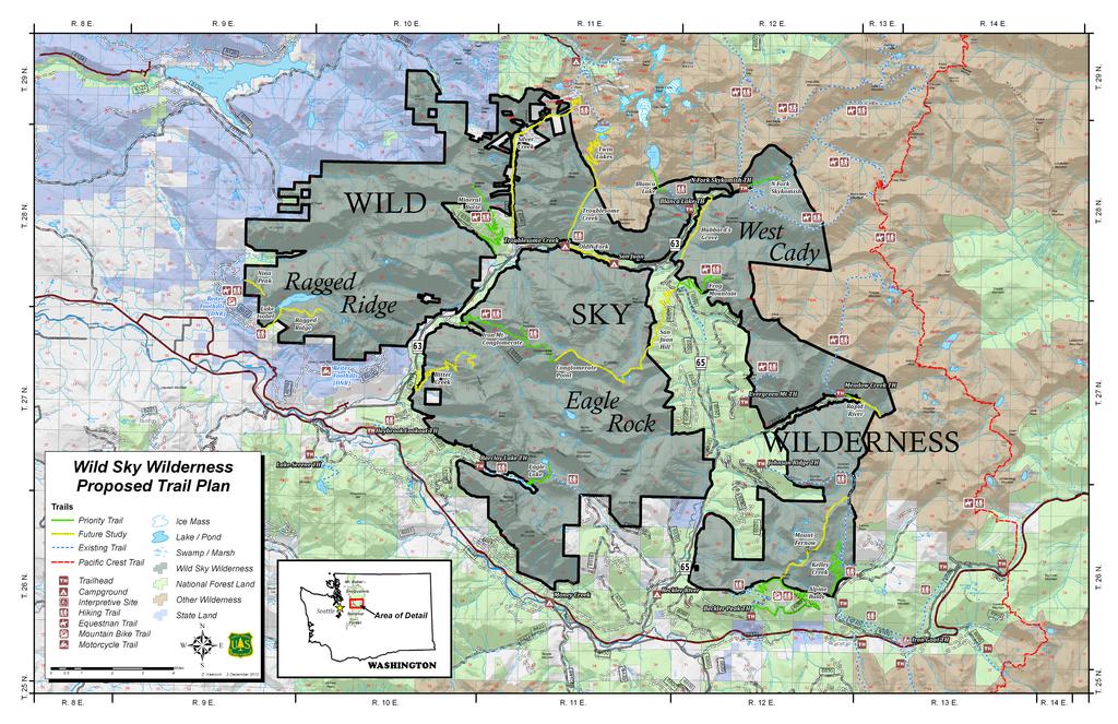
2 Specifically the act reads: TITLE I FOREST SERVICE AUTHORIZATIONS SEC WILD SKY WILDERNESS. (a) ADDITIONS TO THE NATIONAL WILDERNESS PRESERVATION SYSTEM. (2) NEW TRAILS. (A) The Secretary of Agriculture shall consult with interested parties and shall establish a trail plan for Forest Service lands in order to develop (i) a system of hiking and equestrian trails within the wilderness designated by this section in a manner consistent with the Wilderness Act (16 U.S.C et seq.); and (ii) a system of trails adjacent to or to provide access to the wilderness designated by this section. (B) Within 2 years after the date of enactment of this Act, the Secretary of Agriculture shall complete a report on the implementation of the trail plan required under this section. This report shall include the identification of priority trails for development. NEED: Trails serve many functions including: as a means to experience nature, promote physical fitness and mental well-being, provides a leisure time activity to enjoy with friends and family, and to provide access to scenic views, subalpine lakes and meadows, and other trail systems. Waterfall - North Fork Skykomish River Trail use also contributes to the local economy thru expenditures for gas, food, and lodging. Many local business and communities supported the Wild Sky Wilderness due to this benefit to the economy if trail use were to increase. A Port-to-Pass proposal has been developed for an Innovative Partnership Zone for the Skykomish Valley, to stimulate outdoor oriented business. The Wild Sky Wilderness has been identified as a key component. The increasing use of trails is well documented with an increase of about 10% per decade for the State of Washington. Use on the existing trail system of about 150 miles on the Skykomish Ranger District has been at this growth rate or higher. This corresponds to an increase in population of about 17% in Snohomish County between 2000 and The trails with the greatest use include Lake Serene, Barclay Lake, Dorothy Lake, and Blanca Lake. Lakes are a key attraction but these trails also feature good road access, a destination 2


3 easily reachable in a day, old growth forests, and scenic views. These trails also feature issues associated with over use: crowding at the parking lot, along the trail, and at the destination; resource damage such as soil erosion and vegetation loss along the trail and especially at the lakes; and high maintenance and management costs. Clearly additional day use trails to attractive destinations are needed to keep up with trend of increasing use and to disperse users from crowded trails. Conglomerate Point The Wild Sky Wilderness has 3 units: Ragged Ridge, Eagle Rock, and West Cady. The Ragged Ridge unit is a steep, rocky, rugged landscape featuring Lake Isabel on its western boundary. The Eagle Rock unit likewise is steep and rugged and features Mt. Baring and Gunn Peak and Eagle, Simms, Sunset, and Boulder Lakes. The West Cady unit is adjacent to the Henry M. Jackson Wilderness and features large meadows such as W. Cady Ridge along with wild valleys such as Troublesome Creek. There are 67 miles of existing summer trails associated with the Wild Sky Wilderness as shown in the table ( Existing Trails, page 4) below. In addition there are 12.7 miles of winter trails adjacent to the wilderness area. The condition of these trails ranges from poor to good, with drainage or braiding issues noted on some trail segments. Trailheads for these trails range from developed sites with toilets, picnic, tables, and garbage cans to undeveloped trailheads. West Cady Ridge 3
4 EXISTING TRAILS Within and Adjacent to Wild Sky Trail No. NAME Length (Miles) BEGIN TERMINI 650 BALD EAGLE 9.6 CURRY GAP 1050 QUARTZ CREEK N. FORK SKYKOMISH BLANCA LAKE PASS CREEK W. CADY RIDGE 7.7 N. FORK SKYK0MISH N. FORK SKYK0MISH N. FORK SKYK0MISH N. FORK SKYK0MISH N. FORK SKYK0MISH END TERMINI PACIFIC CREST NATIONAL SCENIC TRAIL/DISHPAN GAP CURRY GAP PACIFIC CREST NATIONAL SCENIC TRAIL/DISHPAN GAP BLANCA LAKE PACIFIC CREST NATIONAL SCENIC TRAIL PACIFIC CREST NATIONAL SCENIC TRAIL/CADY GAP 1055 BARCLAY LAKE 2.3 BARCLAY CRK ROAD BARCLAY LAKE DESIGNED USE (Primary Objective) EAGLE LAKE 1.5 BARCLAY LAKE EAGLE LAKE PARADISE MEADOWS 1.5 EAGLE CREEK ROAD EAGLE LAKE 1056 EVERGREEN MT MEADOW CREEK JOHNSON RIDGE HEYBROOK LOOKOUT TRAIL 1076 KELLEY CREEK TROUBLESOME CREEK NATURE TRAIL EVERGREEN MTN RD MEADOW CRK JOHNSON RIDGE ROAD EVERGREEN MOUNTAIN PACIFIC CREST NATIONAL SCENIC TRAIL/DISHPAN GAP JOAN LAKE 1 US HWY 2 HEYBROOK LOOKOUT 0.5 MARTIN CRK TROUBLESOME CREEK CAMPGROUND 1080 LAKE ISABEL 1 RD LK ISABEL 1240 BECKLER PEAK 3.5 BECKLER PEAK ROAD JOHNSON RIDGE TR/SCORPION MTN. TROUBLESOME CREEK CAMPGROUND BECKLER PEAK 6024 BARCLAY CREEK ROAD 6.2 US HWY 2 BARCLAY LAKE 6500 BECKLER RIVER ROAD 6.5 US HWY 2 JCT. W/RAPID RIVER ROAD 4
. Trails must either enter the Wild Sky Wilderness or approach the edge of the Wilderness.")
5 PLANNING PROCESS: In 2011 the USDA Forest Service planning team prepared a map and table showing all proposed trails within the planning area. The team defined the planning area as the Wild Sky Wilderness and adjacent National Forest System Lands (NFSL). Trails must either enter the Wild Sky Wilderness or approach the edge of the Wilderness. Thus the planning area was defined as NFSL to the north of Highway 2 (see map). These proposed trails included trails listed in the 1990 Mt. Baker-Snoqualmie National Forest Land Management Plan; trails proposed during planning for additional trails to disperse use from the Alpine Lakes Wilderness in the mid 1990s; and additional trails proposed during the legislative process. The map of proposed trails and information table was mailed to a list of almost 50 individuals, including representatives of many user and environmental groups. The information was also posted to the Mt. Baker- Snoqualmie National Forest website and a public meeting was held on June 2011 with over 50 attendees including members of Backcountry Horsemen of Washington, hiking and environmental groups, as well as members of the general public. Meeting attendees provided additional proposed trails pushing the number of proposed trails to almost 50. A presentation was made of issues to consider in trail construction and general comments received. In order to begin the process of prioritization of the trails attendees were asked to select their first choice, second choice, and last (or a trail they would not like to see built) choice. Additional written comments were received during the summer of 2011 including letters from the general public, Washington Wilderness Coalition, Wilderness Society, The Mountaineers, Alpine Lakes Protection Society, and North Cascades Conservation Council. In addition, the Wilderness Society and The Mountaineers convened a small group of leaders that also included Washington Trails Association and the Sierra Club and submitted a joint letter. Lake Isabel 5
6


 Future Study (Pages 9-10) Drop from Further Consideration Mt. Daniel from Evergreen Mtn. Mt. Baring from Beckler Peak Scorpion Mountain 7")
7 The FS planning team analyzed these comments and developed a list of key criteria for prioritization of trails. Key criteria or objectives included: Maintenance/reconstruction/relocation of existing trails Construction feasibility/costs and maintenance costs for the trail and trailhead Management issues such as private lands, public safety, and resource damage concerns such as potential impacts to wilderness values, subalpine lakes and grizzly bear core habitat Fulfills a need in the trails system, i.e. is not redundant The planning team ranked the trails into 3 categories: High/Moderate Priority (Page 8) Future Study (Pages 9-10) Drop from Further Consideration Mt. Daniel from Evergreen Mtn. Mt. Baring from Beckler Peak Scorpion Mountain 7
8 PRIORITIZED LIST OF TRAIL PROJECTS WILD SKY WILDERNESS PLANNING AREA Trail No. 1240/ NAME FROG MOUNTAIN ALPINE BALDY/ BECKLER PEAK 1076 KELLEY CREEK 1051 NORTH FORK SKYKOMISH 1052 BLANCA LAKE 1057 MEADOW CREEK EAGLE LAKE BEGIN TERMINI JACKS PASS JUNCTION RD 6066/6067 (JENNIFER DUNN TH) RD 6710 (MARTIN CRK. TH) N. FORK SKYKOMISH TH N. FORK SKYKOMISH ROAD RAPID RIVER ROAD BARCLAY LAKE ENDING TERMINI FROG MT. SUMMIT LOOP VIA ALPINE BALDY, SPUR TO BECKLER PEAK MILES TR PCT 9.1 BLANCA LAKE 3.5 PCT 8.1 EAGLE LK/ PARADISE MEADOWS 2.0 DESIGNED USE LEVEL OF PRIORITY HIGH PRIORITY. Good trailhead site, road-to-trail, west facing slope with meadows, and views from summit. HIGH PRIORITY. Beckler Peak Tr opened 2011, need to decommission part of FSR 6067 to build loop for Mt. bikes/hikers. NEPA complete. HIGH PRIORITY. NEPA completed and work in progress on relocation to Martin Crk TH. As of 2012, 0.9 miles of 3 mile relocation completed by Volunteers for Outdoor Washington. HIGH PRIORITY. Relocation and/or road-to-trail conversion needed first 1.5 miles to prevent future culvert failures and washouts. HIGH PRIORITY. Existing trail is in poor condition approaching ridgeline and down to Blanca Lake and reconstruction is needed due to rough, rocky, and eroded tread. HIGH PRIORITY. Existing trail. Relocation of trailhead to sandpit 1/2 mile up RD 6530, and relocation of 1/2 mile of trail is needed to provide a trailhead suitable to stock. MODERATE PRIORITY. Existing trail (primitive). Need lakeshore mgmt. plan. Need relocation to avoid wetlands in Paradise Meadows, reduce braided trail, and prevent tread erosion. IRON MT/ CONGLOMER- ATE PT RD 6320 CONGLOMER- ATE PT. /SPUR TO IRON MT. 6.8 MODERATE PRIORITY. Long roadto-trail. West facing. Hiker Only spur to Iron Mt. summit. MINERAL BUTTE RD 6330 MINERAL BUTTE SUMMIT 7.7 MODERATE PRIORITY Long roadto-trail w/ matrix mgmt. area and private land. South facing. 8
9 TRAIL PROJECTS LISTED FOR FUTURE CONSIDERATION WILD SKY WILDERNESS PLANNING AREA Trail No. NAME HUBBARD'S GROVE NINA, PINTA, AND ZEKES PEAKS BEGIN TERMINI RD SPUR DNR FROM MAY CRK. ENDING TERMINI RD 68 (DEER FALLS) ZEKES PEAK Length (Miles) (2.0 mi. FS) LEVEL OF PRIORITY FUTURE STUDY. Impressive old growth. Evaluate trail that parallels river (large bridges required) vs. short trail to Goblin Grove. FUTURE STUDY. Long trail to vista point. Long season of use. Access via DNR Reiter Foothills non-motorized area under development. TWIN LAKES TR 1079 (TROUBLE- SOME CR NT) TWIN LAKES 7.1 FUTURE STUDY. Access to Twin Lakes Trail desirable either via this route (Troublesome Crk) or Silver Crk. Rd. especially as Monte Cristo access is more difficult SILVER LAKE OLD N. FORK SKYKOMISH SILVER CR RD (RD 6340) TROUBLESOME CG TR (POODLE DOG PASS) 6.8 SAN JUAN CG 1.8 BITTER CREEK RD 63/ 6310 VISTA PT. 6.5 RAPID RIVER PARADISE MEADOWS LAKE ISABEL # 1080 RAGGED RIDGE RAPID RIVER RD (RD 6530) EAGLE CR RD (RD 6514) RD LK ISABEL (TR 1080) END OF ROAD TR LK ISABEL 2.2 (1.0 mi. is FS) VISTA POINT 2.9 FUTURE STUDY. Access to Twin Lakes Trail desirable either via this route or Troublesome Cr. especially as Monte Cristo access changes. Old road bridges collapsing. Private land and mining claims. FUTURE STUDY. Parallels Index-Galena Rd. Could provide bicycle route between campgrounds. FUTURE STUDY. Road-to-trail. Could avoid lakes and climb up Jumpoff Ridge to Vista Point. FUTURE STUDY. Road-to-trail along river with old growth. Would be an easy hike, although difficult to meet ADA standards as suggested. FUTURE STUDY. Existing primitive hiker only trail. Use is not encouraged currently due to short distance to Eagle Lake and potential to exceed solitude standards. FUTURE STUDY. Existing primitive hiker only trail. Need lakeshore mgmt. plan in conjunction with increased maintenance. Access via DNR Reiter Foothills nonmotorized area under development. Potential mountain bike conflict if maintained. FUTURE STUDY. A segment to a vista point on the ridgeline would help disperse use from Lake Isabel. 9

 TR 1076 VIA JAKES LAKE 5.6 FUTURE STUDY.")
10 TRAIL NO. NAME BEGINNING TERMINI ENDING TERMINI MILES LEVEL OF PRIORITY 1231/ SAN JUAN HILL/ CONGLOMER ATE PT. JACKS PASS OR RD 6570 CONGLOMER- ATE PT from Jacks Pass FUTURE STUDY. Trailhead at Jacks Pass or last switchback on FSR 6570 then road-to-trail to San Juan Hill ridgeline, then west along ridgeline by El Capitan to Conglomerate Pt. Assess need after Iron Mt./Conglomerate Pt. trail is constructed ALPINE BALDY TR 1240 (ALPINE BALDY) TR 1076 VIA JAKES LAKE 5.6 FUTURE STUDY. Identified as high priority in previous planning efforts in 1990s. Would need lakeshore plan for Jakes Lake. Silver Creek from Mineral Butte Historic Trail Sign 10

11 IMPLEMENTATION: Some trail proposals are ongoing, such as Kelley Creek with the relocation being constructed by Volunteers for Outdoor Washington. Other projects had been initiated under other authorities during the Wild Sky deliberations. For example, completion of the Beckler Peak and additions to the Iron Goat Trails help to fulfill the vision of the Wild Sky plan. An application for planning for the Frog Mt. Trail was submitted to the Washington State Non-Highway Road (NOVA) grant program in Funding is needed for planning, design, and construction. Grants, volunteers, and Forest Service funds will need to be leveraged to implement these projects. It typically takes 3 to 5 years to implement a project if funding is received. Site specific analysis and NEPA is required for each trail project which would include additional public involvement and identification of the trail route on the ground. Some projects may be modified or dropped during this analysis. All projects will need to meet the spirit and intent of the Wilderness Act and standards and guidelines of the Mt. Baker-Snoqualmie Land and Resource Management Plan. Burley Mtn. Tarns With the help of partnerships some of these trails can become reality! To volunteer to help maintain and construct Wild Sky Wilderness trails: Washington Trails Association at: Volunteers for Outdoor Washington at: Backcountry Horsemen of Washington at: 11

12 PLANNING TEAM Alpine Baldy Tom Davis, Team Leader Skykomish Ranger District Trails Specialist Kathy White, Trail Design Specialist, Mt. Baker-Snoqualmie National Forest Gary Paull, Forest Trails and Wilderness Coordinator, Mt. Baker-Snoqualmie National Forest Dave Keenum, GIS Specialist Mt. Baker-Snoqualmie National Forest Joe Neal, District Ranger, Skykomish Ranger District 12
13 Wild Sky Wilderness Trail Plan Mt. Baker-Snoqualmie National Forest Website General information about Wild Sky Wilderness
Continental Divide National Scenic Trail Legislative History and Planning Guidance
 Continental Divide National Scenic Trail Legislative History and Planning Guidance Legislation, Policy, and Direction Regarding National Scenic Trails The National Trails System Act, P.L. 90-543, was passed
RUSHMORE CONNECTOR TRAIL PROPOSAL
 PURPOSE AND NEED Background The U.S. Forest Service, Black Hills National Forest (Forest Service) has received a special use permit application from the State of South Dakota Department of Game, Fish and
Central Cascades Wilderness Strategies Project
 Central Cascades Wilderness Strategies Project Wilderness is Unique What makes designated Wilderness different from other national forest lands? Wilderness Act of 1964 to assure that an increasing population
RE: Access Fund Comments on Yosemite National Park Wilderness Stewardship Plan, Preliminary Ideas and Concepts
 September 30, 2016 Superintendent Yosemite National Park Attn: Wilderness Stewardship Plan P.O. Box 577 Yosemite, CA 95389 RE: Access Fund Comments on Yosemite National Park Wilderness Stewardship Plan,
Crystal Lake Area Trails
 Lake Area Trails Welcome to the Lake area of the Big Snowy Mountains! This island mountain range in central Montana features peaks reaching to 8,600 feet and long, high ridges from which vistas of the
Non-motorized Trail Plan & Proposal. August 8, 2014
 Town of Star Valley Ranch, Wyoming and the Star Valley Ranch Association in partnership with the USDA Forest Service, Bridger-Teton National Forest, Greys River Ranger District Non-motorized Trail Plan
Trail Report for KOKANEE GLACIER PROVINCIAL PARK and other Kootenay Lake Area parks (including west side of Purcell Wilderness Conservancy)
") Updated: October 23, 2017 Please call 250-354-6333 if you have new trail conditions to report. PARK AREA ROADS TRAILS ADDITIONAL INFORMATION Kokanee Creek SPECIAL NOTICE: Trail from Gibson Lake to drainage
Updated: October 23, 2017 Please call 250-354-6333 if you have new trail conditions to report. PARK AREA ROADS TRAILS ADDITIONAL INFORMATION Kokanee Creek SPECIAL NOTICE: Trail from Gibson Lake to drainage
playwinterpark.com Off The Beaten Path Hikes Hiking Recommendations for the Adventurous Hiker
 playwinterpark.com Off The Beaten Path Hikes Hiking Recommendations for the Adventurous Hiker Hike: Devil s Thumb (difficult) Length: 3.93 miles one-way Elevation: Trailhead 9609 Destination 12,236 Trailhead
Lava Mountain Trail Distance: Elevation Range: Trail Type: Difficulty: Season: Driving Distance: Driving Time: USGS Maps: Pros Cons
 Lava Mountain Trail Distance: 13.4 miles (including the side trip to North Star Lake) Elevation Range: 5900'-8330' Trail Type: singletrack Difficulty: moderate Season: late June-October Driving Distance:
BACKCOUNTRY TRAIL FLOOD REHABILITATION PROGRAM
 BACKCOUNTRY TRAIL FLOOD REHABILITATION PROGRAM Backcountry Trail Flood Rehabilitation A June 2013 Flood Recovery Program Summary In June 2013, parts of Southern Alberta were devastated from significant
Tracy Ridge Shared Use Trails and Plan Amendment Project
 Tracy Ridge Shared Use Trails and Plan Amendment Project Scoping Document Forest Service Allegheny National Forest Bradford Ranger District McKean, County, Pennsylvania In accordance with Federal civil
BACKSTORY & MMBA RECOMMENDATIONS
 URGENT!! COMMENT PERIOD ENDS MONDAY, MARCH 5 TH, 5PM!! MONTANA MOUNTAIN BICYCLE ALLIANCE RECOMMENDED COMMENTS ON CUSTER GALLATIN FOREST PLAN REVISION, Proposed Actions WINTER 2018 The CGNF Forest Plan
Whitefish Range Partnership Tentatively Approved by WRP 11/18/2013!Rec. Wilderness Page 1
 Whitefish Range Partnership Tentatively Approved by WRP 11/18/2013!Rec. Wilderness Page 1 Recommended Wilderness Background The Whitefish Range has a long management and legislative history associated
National Forest: Snoqualmie National Forest State: WA Counties: King, Snohomish General Location: Central Washington Cascade Range Acres: 105,561
 Wild Sky Wilderness Air Quality Report National Forest: Snoqualmie National Forest State: WA Counties: King, Snohomish General Location: Central Washington Cascade Range Acres: 105,561 Page 1 of 5 Wilderness
Trail Assessment Report
 Trail Assessment Report Trail Options for the Bear Creek Canyon located in Pikes Peak Ranger District, Pike National Forest and on Colorado Springs Utility Lands Due to the presence of a unique species
BACKSTORY & MMBA RECOMMENDATIONS
 URGENT!! COMMENT PERIOD ENDS MONDAY, MARCH 5 TH, 5PM!! MONTANA MOUNTAIN BICYCLE ALLIANCE RECOMMENDED COMMENTS ON CUSTER GALLATIN FOREST PLAN REVISION, Proposed Actions WINTER 2018 The CGNF Forest Plan
White Mountain National Forest Saco Ranger District
 United States Department of Agriculture Forest Service White Mountain National Forest Saco Ranger District 33 Kancamagus Highway Conway, NH 03818 Comm: (603) 447-5448 TTY: (603) 447-3121 File Code: 1950
South Colony Basin Recreation Fee Proposal
 South Colony Basin Recreation Fee Proposal Purpose and Need for Collecting Fees in South Colony Basin: Forest Service appropriated funds have not been sufficient to maintain current recreational services
GATEWAY PHASE 2. U.S. Forest Service and the Mount Shasta Trails Association
 GATEWAY PHASE 2 U.S. Forest Service and the Mount Shasta Trails Association PROJECT DEVELOPMENT Brief history - Gateway Phase 1 - IMBA conceptual plan - BikeShasta: concert series - USFS & MSTA partnered
April 10, Mark Stiles San Juan Public Lands Center Manager 15 Burnett Court Durango, CO Dear Mark,
 Mark Stiles San Juan Public Lands Center Manager 15 Burnett Court Durango, CO 81301 Dear Mark, We are pleased to offer the following comments on the draft San Juan Public Lands Center management plans
September 14, Comments of the Colorado Trail Foundation On the USFS Scoping Notice of August 13, 2010 RE: the relocation of the CDNST/CT Page 1
 THE COLORADO TRAIL FOUNDATION Comments on the U.S. Forest Service Scoping Notice of August 13, 2010 Regarding the Relocation of THE COLORADO TRAIL AND CONTINENTAL DIVIDE NATIONAL SCENIC TRAIL From La Garita
Preferred Recreation Recommendations Stemilt-Squilchuck Recreation Plan March 2018
 Preferred Recreation Recommendations Stemilt-Squilchuck Recreation Plan March 2018 Below are the recommended recreation ideas and strategies that package together the various recreation concepts compiled
Hermosa Area Preservation The Colorado Trail Foundation 4/11/2008
 Hermosa Area Preservation The Colorado Trail Foundation 4/11/2008 Legend d o Tr ail NPA - National Protection Area ra NCA - National Conservation Area o e C Th The Colorado Trail lo FS inventoried Roadless
Eagle Rock Loop Ouachita National Forest Page 1 of 8
 EAGLE ROCK LOOP Eagle Rock Loop Ouachita National Forest Page 1 of 8 Hiking: Biking: Equestrian: Trail Highlights: This trail offers the longest loop trail in Arkansas. A combination of the Little Missouri,
Date Name Trail Segment Conditions, Hazards and General Notes on Trails
 Trail Reports for Sawtooth NRA ***Unless otherwise reported-expect high creeks, snow levels at 7900 ft. and trees on trails. Due to high winds in the area, if trees were previously reported removed there
Decision Memo for Desolation Trail: Mill D to Desolation Lake Trail Relocation
 for Salt Lake County, Utah Uinta-Wasatch-Cache National Forest Salt Lake Ranger District 1. Background The present location of the Desolation Trail (#1159) between Mill D and Desolation Lake follows old
Rogue Gorge (Mt. Stella) Roadless Area-- T30S R3E (primarily in portions of Sections 23, 26, 33, 34 & 35)
 Roadless Area-- T30S R3E (primarily in portions of Sections 23, 26, 33, 34 & 35)") Rogue Gorge (Mt. Stella) Roadless Area-- T30S R3E (primarily in portions of Sections 23, 26, 33, 34 & 35) Rogue River-Siskiyou National Forest--High Cascades Ranger District Upper, higher elevation trail
Rogue Gorge (Mt. Stella) Roadless Area-- T30S R3E (primarily in portions of Sections 23, 26, 33, 34 & 35) Rogue River-Siskiyou National Forest--High Cascades Ranger District Upper, higher elevation trail
PURPOSE AND NEED. Introduction
 Public Scoping: Allocation of Recreation Capacity for Commercial Outfitter Guide Services on North Kruzof Island Trails (Kruzof Island Outfitter Guide) PURPOSE AND NEED Introduction The U.S. Department
Response to Public Comments
 Appendix D Response to Public Comments Comment Letter # Response 1, 2, 3, 4, 5, 7, 8, 9, 10, 11, 12, 13, 14, 15, 16, 17, 18, 19, 20, 22, 23, 24, 25, 26, 27, 29, 30, 31, 32, 33, 34, 35, 36, 37, 38, 39,
U.S.D.A. FOREST SERVICE KETCHUM RANGER DISTRICT 206 SUN VALLEY ROAD P.O. BOX 2356 KETCHUM, ID (208)
") U.S.D.A. FOREST SERVICE KETCHUM RANGER DISTRICT 206 SUN VALLEY ROAD P.O. BOX 2356 KETCHUM, ID 83340 (208) 622-5371 Road and Trail Report 05/8/2015 More trails opened in Greenhorn this week. Only high elevation
U.S.D.A. FOREST SERVICE KETCHUM RANGER DISTRICT 206 SUN VALLEY ROAD P.O. BOX 2356 KETCHUM, ID 83340 (208) 622-5371 Road and Trail Report 05/8/2015 More trails opened in Greenhorn this week. Only high elevation
Figure 1-Example of terracing from livestock
 To: District Ranger Matt Janowiak April 3, 2016 P.O. Box 439, Bayfield, CO 81122 comments-rocky-mountain-san-juan-columbine@fs.fed.us From: Greg Warren Golden, CO 80401 Please consider the following comments
Stephens State Park Trails
 TRAILS OF ALLAMUCHY MOUNTAIN & STEPHENS STATE PARKS Allamuchy Mountain and Stephens State Parks contain 28 marked trails providing access to diverse landscapes for walking, hiking, biking, bird-watching,
Restore and implement protected status that is equivalent, or better than what was lost during the mid-1990 s
 THE ROSSLAND RANGE, OLD GLORY AREA. Executive summary. The Friends of the Rossland Range Society, on behalf of the local outdoor community, seeks to accomplish the following with respect to the Old Glory
Understanding the caring capacity of the visitor experience Provide facilities to support a high level user experience Address visual quality through
 Understanding the caring capacity of the visitor experience Provide facilities to support a high level user experience Address visual quality through recreation ecological restoration opportunities Collaboration
Cr./Left Fork of Boulder Creek/Horse Creek Made it 2.2 miles from Hwy on Left fork of Boulder Creek. Heavy washout;
 Road Inspector Inspection Inspection Date North Fork Mark M. 6/7 Open Boulder Cr. Helitack 6/16 no signs on either section of Boulder Cr. 2) we were able to make it to the creek crossing on Boulder Cr.
Kit Carson-Challenger Ridge Trail Project Annual Performance Report-2014 October 22, 2014
 1 Kit Carson-Challenger Ridge Trail Project Annual Performance Report-2014 October 22, 2014 Willow Lake and Kit Carson Peak 2 SUMMARY The Rocky Mountain Field Institute began Phase 1 of a multi-phase,
Description of the Proposed Action for the Big Creek / Yellow Pine Travel Plan (Snow-free Season) and Big Creek Ford Project
 and Big Creek Ford Project") Description of the Proposed Action for the Big Creek / Yellow Pine Travel Plan (Snow-free Season) and Big Creek Ford Project Payette National Forest Krassel Ranger District Valley and Idaho Counties, Idaho
Description of the Proposed Action for the Big Creek / Yellow Pine Travel Plan (Snow-free Season) and Big Creek Ford Project Payette National Forest Krassel Ranger District Valley and Idaho Counties, Idaho
Stein Valley Nlaka pamux Heritage Park
 Stein Valley Nlaka pamux Heritage Park - Trail Information Update and Winter Advisory November 2017 March 2018 Welcome to Stein Valley Nlaka pamux Heritage Park! **This trail update is to inform park users
Anderson Mt. Proposed Wilderness Additions to the Rogue-Umpqua Divide Wilderness-- T30S R3E (mostly) Sections 4 & 9, and T29S R3E Section 33
 Sections 4 & 9, and T29S R3E Section 33") Anderson Mt. Proposed Wilderness Additions to the Rogue-Umpqua Divide Wilderness-- T30S R3E (mostly) Sections 4 & 9, and T29S R3E Section 33 When the 35,701 acre Rogue-Umpqua Divide Wilderness was designated
Anderson Mt. Proposed Wilderness Additions to the Rogue-Umpqua Divide Wilderness-- T30S R3E (mostly) Sections 4 & 9, and T29S R3E Section 33 When the 35,701 acre Rogue-Umpqua Divide Wilderness was designated
SEGMENT ASSESSMENT REPORT
 2017 SEGMENT ASSESSMENT REPORT SEGMENT 3: MT ROSE / TAHOE MEADOWS TO SPOONER SUMMIT REPORT SUMMARY This report is a compilation of information collected on the Tahoe Rim Trail during assessments performed
Colorado s forests are slated to lose thousands of miles of roads through the new OHV Route Designation process. DON T LET IT HAPPEN!
 Colorado s forests are slated to lose thousands of miles of roads through the new OHV Route Designation process. DON T LET IT HAPPEN! This packet identifies many roads that you may lose if you don t act.
GOLDEN EARS PROVINCIAL PARK
 GOLDEN EARS PROVINCIAL PARK Trail Information as of October 10 th 2015 Do not underestimate the mountainous wilderness of Golden Ears Provincial Park. The combination of rugged terrain and rapidly changing
S Central Coast Heritage Protection Act APRIL 21, 2016
 STATEMENT OF GLENN CASAMASSA ASSOCIATE DEPUTY CHIEF, NATIONAL FOREST SYSTEM U.S. FOREST SERVICE U.S. DEPARTMENT OF AGRICULTURE BEFORE THE UNITED STATES SENATE COMMITTEE ON ENERGY AND NATURAL RESOURCES
DECISION MEMO North Zone (Legacy Trails) Trail Stabilization Project
 Trail Stabilization Project") DECISION MEMO North Zone (Legacy Trails) Trail Stabilization Project USDA FOREST SERVICE Rocky Mountain Region (R2) Shoshone National Forest Wapiti and Greybull Ranger District Park County, Wyoming Background
DECISION MEMO North Zone (Legacy Trails) Trail Stabilization Project USDA FOREST SERVICE Rocky Mountain Region (R2) Shoshone National Forest Wapiti and Greybull Ranger District Park County, Wyoming Background
St. Joe Travel Management Inventoried Roadless Area Report
 St. Joe Travel Management Inventoried Roadless Area Report Lynette Myhre and Tracy Gravelle July 2015 Regulatory Framework Idaho Roadless Rule Roadless area descriptions from the Idaho Roadless Conservation
Partners: Michigan California Timber Company Shasta-Trinity National Forest Pacific Crest Trail Association The Trust for Public Land
 Partners: Michigan California Timber Company Shasta-Trinity National Forest Pacific Crest Trail Association The Trust for Public Land Describe the project location, size, opportunities, and timing. Provide
Paiute Trail Hatfield-McCoy Highwood Mountains
 Paiute Trail Hatfield-McCoy Highwood Mountains Located in Central Utah Main trail is 238 miles 550 miles of designated side trails Links 16 communities in 4 counties Ranges from 5,200 to 11,500 feet Great
Logo Department Name Agency Organization Organization Address Information 5700 North Sabino Canyon Road
 Logo Department Name Agency Organization Organization Address Information United States Forest Coronado National Forest 5700 North Sabino Canyon Road Department of Service Santa Catalina Ranger District
Oregon Equestrian Trails Mt. Hood Chapter
 Oregon Equestrian Trails Mt. Hood Chapter November 17, 2010 To: Michelle Lombardo, Mt. Hood National Forest From: Barb Adams, Oregon Equestrian Trail, Mt. Hood Chapter Re: Barlow and Hood River Ranger
DECISION MEMO. Rawhide Trail #7073 Maintenance and Reconstruction
 Page 1 of 6 Background DECISION MEMO USDA Forest Service Jefferson Ranger District Jefferson County, Montana Rawhide Trail #7073 is located in the Elkhorn Mountain Range approximately 10 miles east of
Bradshaw Trails Series
 Bradshaw Trails Series Curtis James Troop 7014 Curtis.James@erau.edu My Motto: Never get lost! Hiking Rules Bradshaw Hiking Patch Series Hiking Tools Hiking Rules Hiking Merit Badge* Take five 10-mile
Road and Trail Report 05/25/2015
 U.S.D.A. FOREST SERVICE KETCHUM RANGER DISTRICT 206 SUN VALLEY ROAD P.O. BOX 2356 KETCHUM, ID 83340 (208) 622-5371 Road and Trail Report 05/25/2015 Trail and Road conditions remain much the same as last
PROPOSED ACTION South 3000 East Salt Lake City, UT United States Department of Agriculture
 United States Department of Agriculture Forest Service Uinta-Wasatch-Cache National Forest Salt Lake Ranger District 6944 South 3000 East Salt Lake City, UT 84121 801-733-2660 File Code: 1950/2300 Date:
Understanding user expectations And planning for long term sustainability 1
 Understanding user expectations And planning for long term sustainability 1 What is a natural surface trail? It can be as simple has a mineral soil, mulched or graveled pathway, or as developed as elevated
Driving Time: 3 hours (allow extra time for stops)
") Scenic Byways loop This journey takes visitors through the eastern edge of Mt. Rainier National Park and along two of Washington s most beloved scenic byways, the Chinook Byway and the White Pass Scenic
Scenic Byways loop This journey takes visitors through the eastern edge of Mt. Rainier National Park and along two of Washington s most beloved scenic byways, the Chinook Byway and the White Pass Scenic
Route #2) Mt. Massive - Southwest Slopes
 Mt. Massive - Southwest Slopes") Route #2) Mt. Massive - Southwest Slopes Difficulty: Class 2 Ski: Advanced, D6 / R2 / III Exposure: Summit Elevation: Trailhead Elevation: Elevation Gain: Round-trip Length: Trailhead: County Sheriff:
Route #2) Mt. Massive - Southwest Slopes Difficulty: Class 2 Ski: Advanced, D6 / R2 / III Exposure: Summit Elevation: Trailhead Elevation: Elevation Gain: Round-trip Length: Trailhead: County Sheriff:
Date Name Trail Segment Conditions, Hazards and General Notes on Trails
 Trail Reports for Sawtooth NRA ***Unless otherwise reported-expect high creeks, snow levels at 7900 ft. and trees on trails. Due to high winds in the area, if trees were previously reported removed there
ABOUT THE PARKS NANTAHALA NATIONAL FOREST MOUNTAINS NATIONAL PARK CHEROKEE NATIONAL FOREST PISGAH NATIONAL FOREST GREAT SMOKY HIKING TRAILS
 ABOUT THE PARKS GREAT SMOKY MOUNTAINS NATIONAL PARK NANTAHALA NATIONAL FOREST CHEROKEE NATIONAL FOREST PISGAH NATIONAL FOREST GREAT SMOKY MOUNTAINS NATIONAL PARK Straddling the border between North Carolina
Date Name Trail Segment Conditions, Hazards and General Notes on Trails
 Trail Reports for Sawtooth NRA ***Unless otherwise reported-expect high creeks, snow levels at 7900 ft. and trees on trails. Due to high winds in the area, if trees were previously reported removed there
5.0 OUTDOOR RECREATION OPPORTUNITIES AND MANAGEMENT
 5.0 OUTDOOR RECREATION OPPORTUNITIES AND MANAGEMENT 5.1 Introduction This section describes the range of recreational activities that currently take place in Marble Range and Edge Hills Parks, as well
Kit Carson-Challenger Ridge Trail Project
 Kit Carson-Challenger Ridge Trail Project Project Accomplishments Report-USFS December 15, 2015 Photo courtesy of Justin Peterson 815 South 25 th Street, Suite 101 Colorado Springs, CO 80904 Dedicated
Bradley Brook Relocation Project. Scoping Notice. Saco Ranger District. United States Department of Agriculture Forest Service
 Bradley Brook Relocation Project United States Department of Agriculture Forest Service Scoping Notice White Mountain National Forest February 2011 For Information Contact: Jenny Burnett White Mountain
US Forest Service Bears Ears Trail - NFST 1144 California Park to Hole in Wall Creek. Good (1) 2 3
 2 3") Trail Maintenance Endowment Fund Trail Criteria Form The Trail Maintenance Endowment Fund (TMEF) grant criteria form is used in determining the use of funds available on an annual basis. Decisions on how
Trail Maintenance Endowment Fund Trail Criteria Form The Trail Maintenance Endowment Fund (TMEF) grant criteria form is used in determining the use of funds available on an annual basis. Decisions on how
PRIEST LAKE TRAILS. More information contact: Priest Lake Ranger District
 PRIEST LAKE TRAILS The varying terrain in the Priest Lake area ranges from river bottoms with an elevation of 2,600 to 7,500 ft. Valley bottoms, dense forests, meadows and occasional clearings and barren
Wallowa Falls Hydroelectric Project FERC Project No. P-308 Proposed Study Plans - Recreation August 2011
 Wallowa Falls Hydroelectric Project FERC Project No. P-308 August 2011 Prepared by: PacifiCorp Energy Hydro Resources 825 NE Multnomah, Suite 1500 Portland, OR 97232 For Public Review Wallowa Falls Hydroelectric
Decision Memo Sun Valley Super Enduro & Cross-Country Mountain Bike Race. Recreation Event
 Decision Memo 2015 Sun Valley Super Enduro & Cross-Country Mountain Bike Race Recreation Event USDA Forest Service Ketchum Ranger District, Sawtooth National Forest Blaine County, Idaho Background The
St. Joe Travel Management EA CULTURAL RESOURCES
 St. Joe Travel Management EA CULTURAL RESOURCES Bruce Gibson May 2015 Regulatory Framework Forest Plan The Idaho Panhandle National Forests (IPNF) Forest Plan requires systematic cultural resource inventory
A GIS Analysis of Probable High Recreation Use Areas in Three Sisters Wilderness Deschutes and Willamette National Forests
 Lindsey Kiesz Geo 565 Term Project 3/15/2010 A GIS Analysis of Probable High Recreation Use Areas in Three Sisters Wilderness Deschutes and Willamette National Forests Introduction The Three Sisters Wilderness
Trail Beginning Elevation: 7553 ft The Poison Creek Trailhead is located at the end of National Forest Road 646E (NF-646E).
.") West Mountain Trails Poison Creek Trail #134 Length: 2.9 miles (4.7 km) Difficulty Horseback: A good trail for the first time west mountain rider, some steep sections Hiking: Most Difficult USGS Maps:
West Mountain Trails Poison Creek Trail #134 Length: 2.9 miles (4.7 km) Difficulty Horseback: A good trail for the first time west mountain rider, some steep sections Hiking: Most Difficult USGS Maps:
Bear Creek Habitat Improvement Project
 06/10/10 Bear Creek Habitat Improvement Project El Paso County, Colorado Pike National Forest and Colorado Springs Utilities Owned Land Report prepared by: Eric Billmeyer Executive Director Rocky Mountain
Map 1.1 Wenatchee Watershed Land Ownership
 Map 1.1 Wenatchee Watershed Land Ownership Map 1.1 Wenatchee Watershed Land Ownership The Wenatchee watershed lies in the heart of Washington state in Chelan County. Just larger than the state of Rhode
Proposed Action. Payette National Forest Over-Snow Grooming in Valley, Adams and Idaho Counties. United States Department of Agriculture
 United States Department of Agriculture Forest Service January 2012 Proposed Action Payette National Forest Over-Snow Grooming in Valley, Adams and Idaho Counties Payette National Forest Valley, Adams
Sierra National Forest 2015 Wilderness Program Accomplishment Report
 Sierra National Forest 2015 Wilderness Program Accomplishment Report The Sierra National Forest wilderness program provided stewardship and trail maintenance in the Ansel Adams, Dinkey Lakes, John Muir,
FINAL TESTIMONY 1 COMMITTEE ON RESOURCES UNITED STATES HOUSE OF REPRESENTATIVES. July 13, 2005 CONCERNING. Motorized Recreational Use of Federal Lands
 FINAL TESTIMONY 1 STATEMENT OF DALE BOSWORTH CHIEF Of the FOREST SERVICE UNITED STATES DEPARTMENT OF AGRICULTURE Before the SUBCOMMITTEE ON FORESTS AND FOREST HEALTH And the SUBCOMMITTEE ON NATIONAL PARKS,
Trail Notes Palouse Region Hikes
 Trail Notes Palouse Region Hikes Campus Recreation 875 Perimeter Drive MS 1230 Moscow, Idaho 83844-1230 Ph: 208.885.6810 Rentals: 208.885.6170 Fax: 208.885.6879 uidaho.edu/outdoorprogram 0 PALOUSE REGION
BIGHORN BACKCOUNTRY ACCESS MANAGEMENT PLAN
 BIGHORN BACKCOUNTRY ACCESS MANAGEMENT PLAN October, 2002 SPECTACULAR BY NATURE BIGHORN BACKCOUNTRY Alberta s Bighorn Backcountry offers spectacular Rocky Mountain scenery and unforgettable recreational
Williamson Rock/Pacific Crest National Scenic Trail (PCT) Project EIS. Notice of intent to prepare an Environmental Impact Statement.
 Project EIS. Notice of intent to prepare an Environmental Impact Statement.") [3411-15-P] DEPARTMENT OF AGRICULTURE Forest Service Angeles National Forest; Los Angeles County, CA Williamson Rock/Pacific Crest National Scenic Trail (PCT) Project EIS AGENCY: ACTION: Forest Service,
[3411-15-P] DEPARTMENT OF AGRICULTURE Forest Service Angeles National Forest; Los Angeles County, CA Williamson Rock/Pacific Crest National Scenic Trail (PCT) Project EIS AGENCY: ACTION: Forest Service,
Blue Ridge Hiking Club Hike List July- September 2016
 Blue Ridge Hiking Club Hike List July- September 2016 Saturday, July 2, Elk Knob: 3.8 mile round trip with 900 ft. gain in elevation. Spectacular views at the summit. The trails are mostly moderate, but
White Mountain National Forest Saco Ranger District
 United States Department of Agriculture Forest Service White Mountain National Forest 33 Kancamagus Highway Conway, NH 03818 Comm: (603) 447-5448 TTY: (603) 447-3121 File Code: 1950 Date: February 26,
Beaverhead-Deerlodge National Forest Butte Ranger District
 United States Department of Agriculture Forest Service Beaverhead-Deerlodge National Forest 1820 Meadowlark Lane Butte, MT 59701 406 494-2147 File Code: 1950 Date: September 1, 2010 Dear Interested Party:
Trail Phasing Plan. Note: Trails in the Clear Creek Canyon area (Segments will be finalized in the future to minimize wildlife impacts
 Note: Trails in the Clear Creek Canyon area (Segments 2 5 and a future JCOS connection) will be finalized in the future to minimize wildlife impacts Trail Phasing Plan P Parking 3 Easy Trail Intermediate
A Publication of Friends of Sleeping Bear Dunes
 A Publication of Friends of Sleeping Bear Dunes 2014, Friends of Sleeping Bear Dunes, P.O. Box 545, Empire, MI 49630 www.friendsofsleepingbear.org info@friendsofsleepingbear.org Learn more about the Friends
ROAD AND TRAIL PROJECT APPROVAL
 ROAD AND TRAIL PROJECT APPROVAL www.marincountyparks.org Marin County Parks, 3501 Civic Center Dr, Suite 260, San Rafael, CA 94903 DATE: July 12, 2017 PRESERVE: Gary Giacomini Open Space Preserve PROJECT:
Cultural Resource Management Report Deer Valley 4wd Restoration and Blue Lakes Road Maintenance Project R
 Cultural Resource Management Report R2015-05-03-10005 Undertaking Description: The proposes to perform road maintenance and meadow restoration on the Deer Valley 4wd trail and road maintenance on the Blue
TRAILS SANDPOINT RANGER DISTRICT IDAHO PANHANDLE NATIONAL FORESTS. Sandpoint Ranger District 1602 Ontario Street Sandpoint, Idaho (208)
") USDA Forest Service Northern Region IDAHO PANHANDLE NATIONAL FORESTS SANDPOINT RANGER DISTRICT TRAILS Sandpoint Ranger District 1602 Ontario Street Sandpoint, Idaho 83864 (208) 263-5111 HTTP://WWW.FS.USDA.GOV/IPNF
USDA Forest Service Northern Region IDAHO PANHANDLE NATIONAL FORESTS SANDPOINT RANGER DISTRICT TRAILS Sandpoint Ranger District 1602 Ontario Street Sandpoint, Idaho 83864 (208) 263-5111 HTTP://WWW.FS.USDA.GOV/IPNF
RECREATION. Seven issues were identified that pertain to the effects of travel management on outdoor recreation within portions of the project area.
 RECREATION Seven issues were identified that pertain to the effects of travel management on outdoor recreation within portions of the project area. OPPORTUNITIES FOR SOLITUDE / QUIET TRAILS. One attraction
Date Name Trail Segment Conditions, Hazards and General Notes on Trails
 Trail Reports for Sawtooth NRA ***Unless otherwise reported-expect high creeks, snow levels at 7500 ft. and trees on trails. Due to high winds in the area, if trees were previously reported removed there
Geography Faculty Publications and Presentations
 Portland State University PDScholar Geography Faculty Publications and Presentations Geography 5-31-2014 Where Do Mount Baker Snoqualmie National Forest Visitors Go and Which Roads Do They Use To Get There?
LESSON 5 Wilderness Management Case Studies
 LESSON 5 Wilderness Management Case Studies Objectives: Students will: review the key points of the Wilderness Act of 1964. brainstorm solutions for Wilderness management issues. Materials: Í Leave no
MASTER PLAN EXECUTIVE SUMMARY
 Biscuit Run State Park Scottsville Road (State Route 20) Charlottesville, VA 22902 Biscuit Run State Park MASTER PLAN EXECUTIVE SUMMARY Department of Conservation and Recreation Division of Planning and
Wilderness Process #NP-1810: Your letter ID is NP September 5, 2018
 Wilderness Process #NP-1810: Your letter ID is NP-1810-2602-96 September 5, 2018 RE: GMUG Wilderness Evaluation Revised Evaluation Criteria and Draft Report Forest Revision Planning Team: The Continental
National Recreation Trail Application for Designation
 National Recreation Trail Application for Designation Introduction Thank you for your interest in the National Recreation Trail (NRT) program. Completed NRT application packages must be submitted by December
Table of Contents. page 3 Long term Goals Project Scope Project History. 4 User Groups Defined Trail Representative Committee. 5 Trail Users Breakdown
 Launched April 27th, 2010 1 Table of Contents page 3 Long term Goals Project Scope Project History 4 User Groups Defined Trail Representative Committee 5 Trail Users Breakdown 13 Trail Users Desires 16
Friday October 3. Lower Javelina Trail - Level D. about 3 miles, less than 500. Hike Contact: Joel Tormoen
 Friday October 3 Lower Javelina Trail - Level D. about 3 miles, less than 500 Hike Contact: Joel Tormoen joeltormoen@gmail.com Depart WB trailhead 8:00 am - return before 11:00 am This quite easy hike
Date Name Trail Segment Conditions, Hazards and General Notes on Trails
 Trail Reports for Sawtooth NRA ***Unless otherwise reported-expect high creeks, snow levels at 7900 ft. and trees on trails. Due to high winds in the area, if trees were previously reported removed there
White Mountain National Forest. Pond of Safety Accessible Trail & Shoreline Access Project. Scoping Report. Township of Randolph Coos County, NH
 White Mountain National Forest United States Department of Agriculture Forest Service Eastern Region Pond of Safety Accessible Trail & Shoreline Access Project Township of Randolph Coos County, NH Scoping
PacifiCorp North Umpqua Hydroelectric Project FERC Project No VOLUME 1 EXHIBITS
 PacifiCorp North Umpqua Hydroelectric Project FERC Project No. 1927 A VOLUME 1 EXHIBITS TMP and SA Implementation Summary B Settlement Agreement (Section 15) C D E F G H I J K L M N O P Q R S T U Rolling
CHAPTER 5. Chapter 5 Recreation Element
 CHAPTER 5 Recreation Element Chapter 5 Recreation Element The Recreation Element of the Meyers Area Plan is a supplement to the Recreation Element of the TRPA Regional Plan and the El Dorado County General
Piestewa Peak/Dreamy Draw Trail Guide
 Piestewa Peak/Dreamy Draw Trail Guide Trail #1A - Perl Charles Memorial Trail Length: 4.8 miles Elevation: 2,200 ft. - 1,340 ft. Difficulty: Moderate to difficult The Perl Charles trailhead is located
Final Environmental Impact Statement for the Merced Wild and Scenic River. Comprehensive Management Plan, Yosemite National Park, Madera and Mariposa
 This document is scheduled to be published in the Federal Register on 02/26/2014 and available online at http://federalregister.gov/a/2014-04061, and on FDsys.gov DEPARTMENT OF THE INTERIOR 4312-FF NATIONAL