Colorado s forests are slated to lose thousands of miles of roads through the new OHV Route Designation process. DON T LET IT HAPPEN!
|
|
|
- Georgina Russell
- 5 years ago
- Views:
Transcription


1 Colorado s forests are slated to lose thousands of miles of roads through the new OHV Route Designation process. DON T LET IT HAPPEN! This packet identifies many roads that you may lose if you don t act. All you have to do is fill in your name and address and mail this in to the address provided and you re laying the groundwork to keeping your trails open. Please don t delay, the Forest Service must receive this by September 1, (Please remove this sheet before mailing.)
2
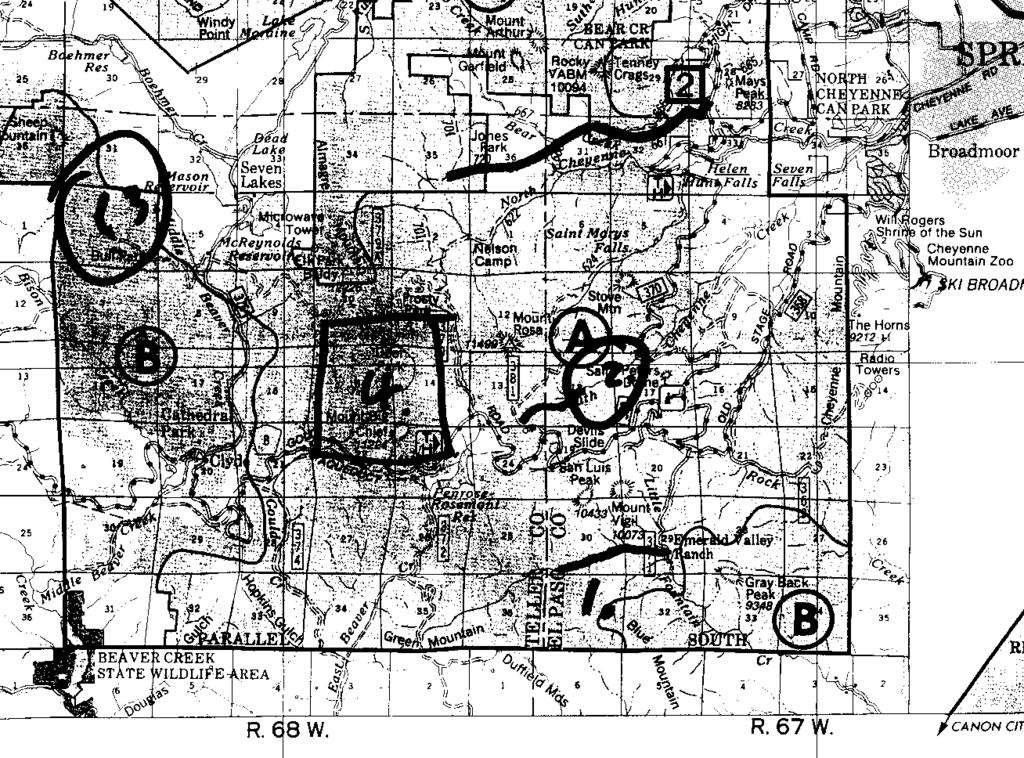
3 Name: Address: City, State, Zip: Date: Attn: Tony Edwards USDA Forest Service Pike & San Isabel National Forests 2840 Kachina Drive Pueblo, CO Dear Mr Edwards: I am concerned about the OHV Route Designation the Forest Service (FS) is undertaking. My concern stems from reviewing the current Pike National Forest (PNF) map and comparing it to topographical maps and what s actually on the ground in the areas I know. To aid in this effort I have taken the liberty of marking the FS map by highlighting 8 areas of concern. Each mark includes a number that is a reference to the numbers in this letter. Also, where possible, I have indicated in a rough manner what the trail looks like. I would also like you to know that there seems to be a tendency of non-motorized users to perceive much more user-conflict than four-wheelers. You should note that we are happy to share the road and give right-of-way to smaller vehicles such as ATV s and motorcycles and we are considerate and sensitive to the needs of horses. If you happen to be confronted with user conflicts from the non-motorized community, please consider mitigating their concerns by educating them on the availability of areas in our forest that can meet their need for quiet and solitude, such as roadless areas, areas categorized as semi-primitive non-motorized, or designated Wilderness areas. Please note that the experiences I get when I go wheeling in the PNF are not available on private lands or in OHV parks as there are none in this area. Therefore, my experiences are not available through other suppliers in this forest s market area and the PNF is the only place that serves as a niche for my recreation. As a result, all of the routes mentioned here should become part of the new OHV designation. Area 1 Trail 371 terminates incorrectly as it continues due west at the Y where Emerald Valley Ranch begins. Currently this road is closed approximately 1.5 miles past the Y and the new map should properly reflect the continuation of this trail. This trail provides access to likely the most unique, diverse, and beautiful canyon near Colorado Springs. It closely hugs a creek and offers several creek crossings, incredibly beautiful views of rock formations high up the hills, and exposure to such beautiful flora as the Lady Yellowslipper Orchid. Also, the terminus of this trail offers an easy turn-around.
4 Area 2 This area denotes several spider-web like mining trails that are absent from the current map and should be included as they offer diverse driving conditions and spectacular views. Just past the start of FSR 381 a trail takes you to a veritable spider-web of connected mining trails. This is not denoted on the current map and should be a designated OHV route because it offers a wonderful opportunity to head deeper into the forest, experience moderately difficult challenges, abandoned structures, and trails that are mostly connected to each other. Further up 381 a side trail identified on the ground and not on the current map as 626 has been closed to motorized travel. This trail used to be open to OHV use and white arrow signs indicated this. The designation apparently changed and the trail was closed and should reappear on the new map with its original designation. A bit further up 381 is a quarry. Although 381 continues from that location due north, a drive through the abandoned mining area due east yields interesting challenges to an OHV along with breath-taking views of Colorado Springs and the huge expanse of the prairie. Many additional spider-web like trails exist that lead to obvious mining testing sites that should also become part of the new designation. Area 3 This area is identified as Bull Park and appears not to show the continuation to the end congruent with signage on the ground. The trail continues up to a large, unique, and beautiful rock formation. Due west you re afforded an incredible view of Bison Reservoir and mining operations near Cripple Creek. Explorations of the area yield remains of old structures, mining equipment, etc. The trail is quite rocky and a wonderful moderately difficult challenge, which also hugs a wetlands area that, depending on the time of year, offers views of beautiful and rarely seen flora. Area 4 This area includes a trail identified as FSR 370C, yet does not appear on the current map. 370C provides likely the most challenging trail close to Colorado Springs. It follows a creek up the mountain and terminates on FSR 379. The termination point allows for further explorations up 379 due west or a return down the mountain due east. This trail offers difficult challenges for specialized OHV vehicles in terms of rocks and dirt moguls; just what serious 4-wheelers look for and can t find anywhere else nearby. Proper identification and OHV route designation of this trail is critically important. Another trail that doesn t appear on the map heads up the mountain to the left prior to 370C. Locals call this trail Saran Wrap and it offers a short yet difficult rocky section that challenges one s driving ability as it becomes narrow at the top. Importantly, one can elect not to take that section and instead run a parallel trail on higher ground to avoid the rock crawling. This is what makes this trail unique as it provides the driver with a choice depending on his or her mood. The trail continues up the mountain and hugs a wetlands area with a creek and beautiful rock formations adjacent to the trail. You are also afforded an opportunity to hang a left and climb up the mountain a bit farther with a steep and challenging trip back down. Area 5 FSR 323 loops around and connects to FSR 324. At the eastern most tip the current map correctly identifies a short section of trail heading due east. The map does not, however, correctly show this trail s continuation down to the Upper Reservoir of Chautauqua Mtn. Beyond the beauty of the trail and incredible vistas, it winds through the forest down to the reservoir and in doing so offers many unique challenges such as deep ruts, tight turns around rocks, and articulation challenges matched nowhere in the Pike National Forest.
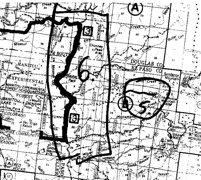
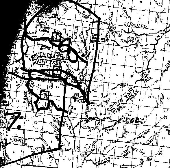
5 Area 6 This section identifies a portion of Rampart Range Road or FSR 300 that is gated. This road can be first accessed due south at Garden of the Gods in Colorado Springs. Travel due north would take you to a beautiful area known as Devil s Head with a Lookout and many OHV trails. However, due to the closure visitors from Colorado Springs cannot access that northern area unless they take I-25 for a good stretch first. This unnecessary inconvenience should be corrected by removing the gate and by properly identifying its location. Area 7 This area is east of FSR 360 and north of the Happy Meadows campground. There are several trails that lead from FSR 360, due east, to the South Platte River. Many of these trails are currently closed, such as FSR 897 and FSR 220. The original rationale for closure was due to erosion stemming from the Hayman fire several years ago. Since these trails are still closed, my fear is that the FS will remove them from the new map. This is a unique area in that it provides a different view of our forest than what you will find closer to Pikes Peak. In addition, since these trails lead down to the river, they provide for wonderful experiences that can only be had on such a beautiful river. Area 8 This area, just north of the start of the northern section of FSR 220 (Hackett Gulch), also contains several trails that are currently closed. Some are marked on the current map, such as FSR 540, others are not. For the same reasons as mentioned for Area 7, these roads should become part of the new OHV designation. Thank you for your attention to this writing and I am looking forward to the additional steps taken in the new OHV route designation process.
6
7
8
RECREATION. Seven issues were identified that pertain to the effects of travel management on outdoor recreation within portions of the project area.
 RECREATION Seven issues were identified that pertain to the effects of travel management on outdoor recreation within portions of the project area. OPPORTUNITIES FOR SOLITUDE / QUIET TRAILS. One attraction
Telluride-to-Moab Alternative Singletrack Options
 Telluride-to-Moab Alternative Singletrack Options Day 1 Day 1 Alternate 1: Galloping Goose to Deep Creek. 18.4 miles, ascent 3,530ft, descent 1,388ft. This is fun, flowey, moderate to intermediate singletrack
5.0 OUTDOOR RECREATION OPPORTUNITIES AND MANAGEMENT
 5.0 OUTDOOR RECREATION OPPORTUNITIES AND MANAGEMENT 5.1 Introduction This section describes the range of recreational activities that currently take place in Marble Range and Edge Hills Parks, as well
Beaverhead-Deerlodge National Forest Butte Ranger District
 United States Department of Agriculture Forest Service Beaverhead-Deerlodge National Forest 1820 Meadowlark Lane Butte, MT 59701 406 494-2147 File Code: 1950 Date: September 1, 2010 Dear Interested Party:
Rogue Gorge (Mt. Stella) Roadless Area-- T30S R3E (primarily in portions of Sections 23, 26, 33, 34 & 35)
 Roadless Area-- T30S R3E (primarily in portions of Sections 23, 26, 33, 34 & 35)") Rogue Gorge (Mt. Stella) Roadless Area-- T30S R3E (primarily in portions of Sections 23, 26, 33, 34 & 35) Rogue River-Siskiyou National Forest--High Cascades Ranger District Upper, higher elevation trail
Rogue Gorge (Mt. Stella) Roadless Area-- T30S R3E (primarily in portions of Sections 23, 26, 33, 34 & 35) Rogue River-Siskiyou National Forest--High Cascades Ranger District Upper, higher elevation trail
Lava Mountain Trail Distance: Elevation Range: Trail Type: Difficulty: Season: Driving Distance: Driving Time: USGS Maps: Pros Cons
 Lava Mountain Trail Distance: 13.4 miles (including the side trip to North Star Lake) Elevation Range: 5900'-8330' Trail Type: singletrack Difficulty: moderate Season: late June-October Driving Distance:
Trail Beginning Elevation: 7553 ft The Poison Creek Trailhead is located at the end of National Forest Road 646E (NF-646E).
.") West Mountain Trails Poison Creek Trail #134 Length: 2.9 miles (4.7 km) Difficulty Horseback: A good trail for the first time west mountain rider, some steep sections Hiking: Most Difficult USGS Maps:
West Mountain Trails Poison Creek Trail #134 Length: 2.9 miles (4.7 km) Difficulty Horseback: A good trail for the first time west mountain rider, some steep sections Hiking: Most Difficult USGS Maps:
Kit Carson-Challenger Ridge Trail Project Annual Performance Report-2014 October 22, 2014
 1 Kit Carson-Challenger Ridge Trail Project Annual Performance Report-2014 October 22, 2014 Willow Lake and Kit Carson Peak 2 SUMMARY The Rocky Mountain Field Institute began Phase 1 of a multi-phase,
Non-motorized Trail Plan & Proposal. August 8, 2014
 Town of Star Valley Ranch, Wyoming and the Star Valley Ranch Association in partnership with the USDA Forest Service, Bridger-Teton National Forest, Greys River Ranger District Non-motorized Trail Plan
Table of Contents. page 3 Long term Goals Project Scope Project History. 4 User Groups Defined Trail Representative Committee. 5 Trail Users Breakdown
 Launched April 27th, 2010 1 Table of Contents page 3 Long term Goals Project Scope Project History 4 User Groups Defined Trail Representative Committee 5 Trail Users Breakdown 13 Trail Users Desires 16
Preferred Recreation Recommendations Stemilt-Squilchuck Recreation Plan March 2018
 Preferred Recreation Recommendations Stemilt-Squilchuck Recreation Plan March 2018 Below are the recommended recreation ideas and strategies that package together the various recreation concepts compiled
Crystal Lake Area Trails
 Lake Area Trails Welcome to the Lake area of the Big Snowy Mountains! This island mountain range in central Montana features peaks reaching to 8,600 feet and long, high ridges from which vistas of the
Description of the Proposed Action for the Big Creek / Yellow Pine Travel Plan (Snow-free Season) and Big Creek Ford Project
 and Big Creek Ford Project") Description of the Proposed Action for the Big Creek / Yellow Pine Travel Plan (Snow-free Season) and Big Creek Ford Project Payette National Forest Krassel Ranger District Valley and Idaho Counties, Idaho
Description of the Proposed Action for the Big Creek / Yellow Pine Travel Plan (Snow-free Season) and Big Creek Ford Project Payette National Forest Krassel Ranger District Valley and Idaho Counties, Idaho
Olympia Adventures OlympiaAdventures.com
 Olympia Adventures OlympiaAdventures.com 832-689-8282 Summer Games Retreat, Western Style Adventure Colorado Springs Trip Summary: Arrival/Departure airport: Colorado Springs Airport (COS) This trip begins
SDTrucksprings. Indiana Off-roading/4x4 Guide Copyright 2015 We Specialize In:
 SDTrucksprings Indiana Off-roading/4x4 Guide Copyright 2015 We Specialize In: Helper Springs Air Bags Leaf Springs Body Lift Kits Coil Springs Timbren Kits Hellwig Springs Lift Blocks And More! Visit www.sdtrucksprings.com
March 14, SUBJECT: Public input to the Bureau of Land Management, Gunnison Field Office, Travel Management Plan
 March 14, 2019 Delivered via email to ewaters@blm.gov Elijah Waters Field Manager BLM Gunnison Field Office Gunnison, CO 81230 SUBJECT: Public input to the Bureau of Land Management, Gunnison Field Office,
FINAL TESTIMONY 1 COMMITTEE ON RESOURCES UNITED STATES HOUSE OF REPRESENTATIVES. July 13, 2005 CONCERNING. Motorized Recreational Use of Federal Lands
 FINAL TESTIMONY 1 STATEMENT OF DALE BOSWORTH CHIEF Of the FOREST SERVICE UNITED STATES DEPARTMENT OF AGRICULTURE Before the SUBCOMMITTEE ON FORESTS AND FOREST HEALTH And the SUBCOMMITTEE ON NATIONAL PARKS,
Decision Memo Broken Wheel Ranch Equestrian Outfitter Special-Use Permit Proposed Action
 Decision Memo Broken Wheel Ranch Equestrian Outfitter Special-Use Permit USDA Forest Service Mississippi Bluffs Ranger District, Shawnee National Forest Jackson and Union Counties, Illinois Proposed Action
Anderson Mt. Proposed Wilderness Additions to the Rogue-Umpqua Divide Wilderness-- T30S R3E (mostly) Sections 4 & 9, and T29S R3E Section 33
 Sections 4 & 9, and T29S R3E Section 33") Anderson Mt. Proposed Wilderness Additions to the Rogue-Umpqua Divide Wilderness-- T30S R3E (mostly) Sections 4 & 9, and T29S R3E Section 33 When the 35,701 acre Rogue-Umpqua Divide Wilderness was designated
Anderson Mt. Proposed Wilderness Additions to the Rogue-Umpqua Divide Wilderness-- T30S R3E (mostly) Sections 4 & 9, and T29S R3E Section 33 When the 35,701 acre Rogue-Umpqua Divide Wilderness was designated
Trout-West Fuels Reduction Project Pike/San Isabel National Forest Recreation Specialist Report Jan Langerman
 Trout-West Fuels Reduction Project Pike/San Isabel National Forest Recreation Specialist Report Jan Langerman Note: If there are any inconsistencies between this report and the Trout-West Final EIS, the
CIEC 9 PEAKS AWARD SUPPLEMENT POSSIBLE ROUTES FOR THE 9 PEAKS AWARD TRIP
 CIEC 9 PEAKS AWARD SUPPLEMENT POSSIBLE ROUTES FOR THE 9 PEAKS AWARD TRIP As you plan your trip, be aware of 3 regulations in this wilderness: 1. Camp only in designated campsites. 2. No campfires allowed.
Proposal to Redevelop Lower Kananaskis River-Barrier Lake. Bow Valley Provincial Park
 Frequently Asked Questions Proposal to Redevelop Lower Kananaskis River-Barrier Lake Bow Valley Provincial Park Frequently Asked Questions What has been decided? What are the details of the plan? What
National Recreation Trail Update Form
 National Recreation Trail Update Form Introduction Thank you for taking the time to complete this form. Your assistance will help ensure that the National Recreation Trail (NRT) database is complete and
THE HISTORIC TRAINS OF COLORADO With Five Historic Rail Excursions September 13-20, 2018
 THE HISTORIC TRAINS OF COLORADO With Five Historic Rail Excursions September 13-20, 2018 8 DAYS TOUR HIGHLIGHTS & INCLUSIONS Roundtrip Airfare Deluxe Motorcoach Transportation 7 Nights Quality Accommodations
Beaver Country Trails ATV Jamboree
 Beaver Country Trails ATV Jamboree #1 Lincoln Mine Intermediate (Open to all ATVs/UTVs) 34 Miles Highlights: This ride will highlight the historic Lincoln Mining District, the first lead mine in Utah,
Three Sisters Wilderness Oct. 2009
 Three Sisters Wilderness Oct. 2009 I was in Bend, OR and had the whole day to travel back to Boise so I decided to take a hike to the popular Green Lakes and summit the South Sister in Three Sisters Wilderness.
Trail Report for KOKANEE GLACIER PROVINCIAL PARK and other Kootenay Lake Area parks (including west side of Purcell Wilderness Conservancy)
") Updated: October 23, 2017 Please call 250-354-6333 if you have new trail conditions to report. PARK AREA ROADS TRAILS ADDITIONAL INFORMATION Kokanee Creek SPECIAL NOTICE: Trail from Gibson Lake to drainage
Updated: October 23, 2017 Please call 250-354-6333 if you have new trail conditions to report. PARK AREA ROADS TRAILS ADDITIONAL INFORMATION Kokanee Creek SPECIAL NOTICE: Trail from Gibson Lake to drainage
NATIONAL ATV / UTV JAMBOREE RIDES
 NATIONAL ATV / UTV JAMBOREE RIDES Note: Rides range from Beginner to Advanced and will last from 2 to 3 hours or an entire day of riding. 1. DESERT RIDE (CLEAR LAKE BIRD REFUGE & LACE CURTAINS/LAVA TUBES)
Coconino National Forest Potential Wilderness Proposal
 Coconino National Forest Potential Wilderness Proposal As part of their Forest Plan Update, the Coconino National Forest needs to address the need for additional wilderness. The last evaluation was done
South Colony Basin Recreation Fee Proposal
 South Colony Basin Recreation Fee Proposal Purpose and Need for Collecting Fees in South Colony Basin: Forest Service appropriated funds have not been sufficient to maintain current recreational services
Wild Sky Wilderness Area
 Wild Sky Wilderness Area M T. B A K E R - S N O Q U A L M I E N A T I O N A L F O R E S T S K Y K O M I S H R A N G E R D I S T R I C T USDA FOREST SERVICE WILD SKY WILDERNESS AREA TRAIL PLAN On May 8,
National Recreation Trail Application for Designation
 National Recreation Trail Application for Designation Introduction Thank you for your interest in the National Recreation Trail (NRT) program. Completed NRT application packages must be submitted by December
Trains & Parks of Colorado June 23 - July 1, 2018
 Warther Tours Presents: Trains & Parks of Colorado June 23 - July 1, 2018 Join Mark Warther on this personally designed adventure through majestic Colorado, the premier destination for rail excursions.
Proposal to Redevelop Lower Kananaskis River-Barrier Lake. Bow Valley Provincial Park. Frequently Asked Questions
 Proposal to Redevelop Lower Kananaskis River-Barrier Lake Bow Valley Provincial Park Frequently Asked Questions What is being proposed? What are the details of the proposal? Where is the project area located?
playwinterpark.com Off The Beaten Path Hikes Hiking Recommendations for the Adventurous Hiker
 playwinterpark.com Off The Beaten Path Hikes Hiking Recommendations for the Adventurous Hiker Hike: Devil s Thumb (difficult) Length: 3.93 miles one-way Elevation: Trailhead 9609 Destination 12,236 Trailhead
Trail Assessment Report
 Trail Assessment Report Trail Options for the Bear Creek Canyon located in Pikes Peak Ranger District, Pike National Forest and on Colorado Springs Utility Lands Due to the presence of a unique species
At the time, the portion of the line through Eagle County remains wholly under the ownership of Union Pacific Railroad (UP).
.") Chapter 5 The Railroad Corridor as a Trail Corridor The intent of this chapter is to identify how the rail corridor, if available for lease or purchase in all or part, could be incorporated into the core
Chapter 5 The Railroad Corridor as a Trail Corridor The intent of this chapter is to identify how the rail corridor, if available for lease or purchase in all or part, could be incorporated into the core
Skiing and Snowshoes on Un-groomed Fernan Saddle Terrain
 Skiing and Snowshoes on Un-groomed Fernan Saddle Terrain Three ski or snowshoe routes are available from the Fernan Saddle Parking Lot which either do not cover routes ordinarily groomed for snow machine
Lakes Landscape Travel Management
 Decision Notice & Finding of No Significant Impact Lakes Landscape Travel Management USDA Forest Service Columbine Ranger District, San Juan National Forest Archuleta, Hinsdale, and La Plata Counties,
Daisy Dean Trail 628/619 ATV Trail Construction
 Background and Purpose and Need The Daisy Dean ATV Trail Construction Project is located in the Little Belt Mountains, Musselshell Ranger District, Lewis and Clark National Forest approximately 32 miles
(Short Listing) DUPUYER ACREAGE, ROCKY MOUNTAN FRONT
 DUPUYER ACREAGE, ROCKY MOUNTAN FRONT") (Short Listing) DUPUYER ACREAGE, ROCKY MOUNTAN FRONT This unique property is located 8½ miles northwest of Dupuyer, Montana and approximately thirty 30 miles northwest of Choteau, Montana. Great Falls
(Short Listing) DUPUYER ACREAGE, ROCKY MOUNTAN FRONT This unique property is located 8½ miles northwest of Dupuyer, Montana and approximately thirty 30 miles northwest of Choteau, Montana. Great Falls
Tracy Ridge Shared Use Trails and Plan Amendment Project
 Tracy Ridge Shared Use Trails and Plan Amendment Project Scoping Document Forest Service Allegheny National Forest Bradford Ranger District McKean, County, Pennsylvania In accordance with Federal civil
Other Agencies and Organizations
 Daniel Boone National Forest 1700 Bypass Road WInchester, KY 40391 859-745-3100 Location Northern terminus is near Morehead, Kentucky. Southern terminus is located in the Big South Fork NRRA in Tennessee.
DECISION MEMO. Rawhide Trail #7073 Maintenance and Reconstruction
 Page 1 of 6 Background DECISION MEMO USDA Forest Service Jefferson Ranger District Jefferson County, Montana Rawhide Trail #7073 is located in the Elkhorn Mountain Range approximately 10 miles east of
Appendix I Case-Studies in Wilderness Management
 Appendix I Case-Studies in Wilderness Management Management Issue Scenarios Note: These scenarios are meant to be used as guidelines for the program leader rather than to be read verbatim. Introduce a
Date Name Trail Segment Conditions, Hazards and General Notes on Trails
 Trail Reports for Sawtooth NRA ***Unless otherwise reported-expect high creeks, snow levels at 7900 ft. and trees on trails. Due to high winds in the area, if trees were previously reported removed there
LAS VARAS RANCH CA COASTAL TRAIL PROPOSED ALIGNMENT
 LAS VARAS RANCH CA COASTAL TRAIL PROPOSED ALIGNMENT Santa Barbara Trails Council * Prepared by Ray Ford February 1,2012 The following notes accompany the Santa Barbara Trails Council map for the Las Varas
SIMON CANYON AREA OF CRITICAL ENVIRONMENTAL CONCERN (ACEC)
") SIMON CANYON AREA OF CRITICAL ENVIRONMENTAL CONCERN (ACEC) Activities: Facilities: Season / Hours: Description: Hiking, backpacking, fishing, picnicking, watchable wildlife. A graveled parking area, picnic
SIMON CANYON AREA OF CRITICAL ENVIRONMENTAL CONCERN (ACEC) Activities: Facilities: Season / Hours: Description: Hiking, backpacking, fishing, picnicking, watchable wildlife. A graveled parking area, picnic
Stein Valley Nlaka pamux Heritage Park
 Stein Valley Nlaka pamux Heritage Park - Trail Information Update and Winter Advisory November 2017 March 2018 Welcome to Stein Valley Nlaka pamux Heritage Park! **This trail update is to inform park users
RECREATION ACCESS AND COMMUNITY ENRICHMENT PLAN
 Template for facilitating Siskiyou County, the City of Yreka and the State of Jefferson in a RECREATION ACCESS AND COMMUNITY ENRICHMENT PLAN Access to the Mountains CREATING ACCESS TO PUBLIC AND PRIVATE
World. Drive Holidays. Guided Seattle to Denver 16 Days / 15 Nights. Available Summer, Autumn. Day 1 - Seattle Arrival
 Canada & Yellowstone Guided Motorcycle Tour Guided Seattle to Denver 16 Days / 15 Nights Available Summer, Autumn This once in a lifetime journey takes you from the emerald waters of Seattle, through the
Date Name Trail Segment Conditions, Hazards and General Notes on Trails
 Trail Reports for Sawtooth NRA ***Unless otherwise reported-expect high creeks, snow levels at 7500 ft. and trees on trails. Due to high winds in the area, if trees were previously reported removed there
St. Joe Travel Management EA CULTURAL RESOURCES
 St. Joe Travel Management EA CULTURAL RESOURCES Bruce Gibson May 2015 Regulatory Framework Forest Plan The Idaho Panhandle National Forests (IPNF) Forest Plan requires systematic cultural resource inventory
Trail Phasing Plan. Note: Trails in the Clear Creek Canyon area (Segments will be finalized in the future to minimize wildlife impacts
 Note: Trails in the Clear Creek Canyon area (Segments 2 5 and a future JCOS connection) will be finalized in the future to minimize wildlife impacts Trail Phasing Plan P Parking 3 Easy Trail Intermediate
Massanutten Mountain Cluster
 Massanutten Mountain Cluster Signal Knob Catback Mountain Southern Massanutten Mountain Five areas of almost 49,000 acres on the Lee Ranger District compose the Massanutten Mountain Cluster of Mountain
CONTENTS. 31 THE TRAILS See next page for a complete listing of all trails and a locator map. Trail descriptions begin on page 31.
 CONTENTS Page Topic 6 Trail List 7 Trail Locator Map 8 Trails Listed by Dificulty 9 Trail Ratings Deined 11 INTRODUCTION 11 Using this Book 12 The Right Trail for You 13 About Moab 15 Utah OHV Laws and
Date Name Trail Segment Conditions, Hazards and General Notes on Trails
 Trail Reports for Sawtooth NRA ***Unless otherwise reported-expect high creeks, snow levels at 7900 ft. and trees on trails. Due to high winds in the area, if trees were previously reported removed there
Mark Warther $2695 PP Dbl (plus air) Warther Tours can handle all air arrangements
 Warther Tours can handle all air arrangements") Warther Tours Presents: Trains & Parks of Colorado August 3rd - 11th, 2019 With train expert and Colorado enthusiast, Mark Warther as featured in Home & Away Magazine Travel Colorado with train expert
Warther Tours Presents: Trains & Parks of Colorado August 3rd - 11th, 2019 With train expert and Colorado enthusiast, Mark Warther as featured in Home & Away Magazine Travel Colorado with train expert
Procedure for the Use of Power-Driven Mobility Devices on Mass Audubon Sanctuaries 1 September 17, 2012
 Procedure for the Use of Power-Driven Mobility Devices on Mass Audubon Sanctuaries 1 September 17, 2012 Background As part of Mass Audubon s mission to preserve the nature of Massachusetts for people and
White Mountain National Forest Saco Ranger District
 United States Department of Agriculture Forest Service White Mountain National Forest 33 Kancamagus Highway Conway, NH 03818 Comm: (603) 447-5448 TTY: (603) 447-3121 File Code: 1950 Date: February 26,
SDTrucksprings. Arkansas Off-roading/4x4 Guide Copyright 2015 We Specialize In:
 SDTrucksprings Arkansas Off-roading/4x4 Guide Copyright 2015 We Specialize In: Helper Springs Air Bags Leaf Springs Body Lift Kits Coil Springs Timbren Kits Hellwig Springs Lift Blocks And More! Visit
Projects Awarded GOCO Funding in El Paso County
 Grant Type Fiscal Year Sponsor Title Grant Amount Acres Conserved Inspire 2016 City of Colorado Springs Out the Door Pikes Peak! $75,000.00 0 Parks 2016 Colorado State Parks 2016 City of Manitou Springs
Stephens State Park Trails
 TRAILS OF ALLAMUCHY MOUNTAIN & STEPHENS STATE PARKS Allamuchy Mountain and Stephens State Parks contain 28 marked trails providing access to diverse landscapes for walking, hiking, biking, bird-watching,
Recreation Opportunity Spectrum for River Management v
 Recreation Opportunity Spectrum for Management v. 120803 Introduction The following Recreation Opportunity Spectrum (ROS) characterizations and matrices mirror the presentation in the ROS Primer and Field
Date Name Trail Segment Conditions, Hazards and General Notes on Trails
 Trail Reports for Sawtooth NRA ***Unless otherwise reported-expect high creeks, snow levels at 7900 ft. and trees on trails. Due to high winds in the area, if trees were previously reported removed there
Bradley Brook Relocation Project. Scoping Notice. Saco Ranger District. United States Department of Agriculture Forest Service
 Bradley Brook Relocation Project United States Department of Agriculture Forest Service Scoping Notice White Mountain National Forest February 2011 For Information Contact: Jenny Burnett White Mountain
Minnesota Off-Road Cyclists
 Minnesota Off-Road Cyclists MORC Mission Minnesota Off-Road Cyclists is a nonprofit volunteer organization dedicated to safeguarding the future of mountain biking in Minnesota through the promotion of
Route #2) Mt. Massive - Southwest Slopes
 Mt. Massive - Southwest Slopes") Route #2) Mt. Massive - Southwest Slopes Difficulty: Class 2 Ski: Advanced, D6 / R2 / III Exposure: Summit Elevation: Trailhead Elevation: Elevation Gain: Round-trip Length: Trailhead: County Sheriff:
Route #2) Mt. Massive - Southwest Slopes Difficulty: Class 2 Ski: Advanced, D6 / R2 / III Exposure: Summit Elevation: Trailhead Elevation: Elevation Gain: Round-trip Length: Trailhead: County Sheriff:
STONE MOUNTAIN PROVINCIAL PARK Purpose Statement and Zoning Plan
 1 STONE MOUNTAIN PROVINCIAL PARK Purpose Statement and Zoning Plan Stone Mountain Provincial Park is situated 140 km west of Fort Nelson at Kilometre 595 of the Alaska Highway. The 25 690 ha park is located
AOTA ArtTrek Locations
 AOTA ArtTrek Locations ArtTrek is a summer-long Grand County, CO art adventure. Highlighted by snow-covered mountain vistas and rolling meadows threaded with sparkling streams and rivers, numerous sites
USDA TRAILS STRATEGY PROGRAM
 USDA TRAILS STRATEGY PROGRAM WRPI Program: English Peak Survey Jorge D. Briceño Southwestern Community College Internship Time Period: June 6, 2016 August 8, 2016 Advisor: Sam Commarto Recreation Officer
Rocky Mountain National Park Hiking Map By Trails Illustrated Maps
 Rocky Mountain National Park Hiking Map By Trails Illustrated Maps 10 Great Hikes for Families with Kids in Estes Park, Colorado - Choose from plenty of great family hikes in Rocky Mountain National park.
GATEWAY PHASE 2. U.S. Forest Service and the Mount Shasta Trails Association
 GATEWAY PHASE 2 U.S. Forest Service and the Mount Shasta Trails Association PROJECT DEVELOPMENT Brief history - Gateway Phase 1 - IMBA conceptual plan - BikeShasta: concert series - USFS & MSTA partnered
Date Name Trail Segment Conditions, Hazards and General Notes on Trails
 Trail Reports for Sawtooth NRA ***Unless otherwise reported-expect high creeks, snow levels at 7900 ft. and trees on trails. Due to high winds in the area, if trees were previously reported removed there
American Conservation Experience
 ACE Project Report For Tonto National Forest, Arizona Trail Association and Arizona State Parks Title of Project: 4 Peaks Trail Maintenance Award Contract Number: ASP NM11021 Project Partner: Paul Burghard
MOAB Multi-Day (update ) RUN ANNOUNCEMENT
 RUN ANNOUNCEMENT") MOAB Multi-Day (update 02-06-18) RUN ANNOUNCEMENT RUN FULL NO MORE RSVPs ACCEPTED Date: March 31st to April 6th 2018 Trail Leader: Mike Wallace (714) 504-8514 Max Vehicle Limit Reached Meeting Tims: To
MOAB Multi-Day (update 02-06-18) RUN ANNOUNCEMENT RUN FULL NO MORE RSVPs ACCEPTED Date: March 31st to April 6th 2018 Trail Leader: Mike Wallace (714) 504-8514 Max Vehicle Limit Reached Meeting Tims: To
Paiute Trail Hatfield-McCoy Highwood Mountains
 Paiute Trail Hatfield-McCoy Highwood Mountains Located in Central Utah Main trail is 238 miles 550 miles of designated side trails Links 16 communities in 4 counties Ranges from 5,200 to 11,500 feet Great
GOLDEN EARS PROVINCIAL PARK
 GOLDEN EARS PROVINCIAL PARK Trail Information as of October 10 th 2015 Do not underestimate the mountainous wilderness of Golden Ears Provincial Park. The combination of rugged terrain and rapidly changing
The Roots of Carrying Capacity
 1 Applying Carrying Capacity Concepts in Wilderness 1872 1964...shall be preserved for the use & enjoyment of the American people...in such manner as will leave them unimpaired for future generations...
COLORADO TRAIN ADVENTURE
 COLORADO TRAIN ADVENTURE by Melody Hagerman at Travel the Horizon Summary Traveling by rail in Colorado is the most spectacular way to take in its unique scenery. From high above the tracks, you'll enjoy
The success of this club and the events it provides to its members is directly related to the participation by its members
 END OF 2016 nwtra.com North West Trail Riders Association PO Box 571, Pendleton, OR 97801 Email: contact@nwtra.com Club President: Geoff Reiff Vice President: Brandon Robinson Treasurer: Chuck Overstreet
LESSON 5 Wilderness Management Case Studies
 LESSON 5 Wilderness Management Case Studies Objectives: Students will: review the key points of the Wilderness Act of 1964. brainstorm solutions for Wilderness management issues. Materials: Í Leave no
Brinker Creek Ranch. Colorado - Routt County - Yampa
 Located at the base of the Flattops Range in the Steamboat/Vail corridor, Brinker Creek Ranch consists of 1,451 acres ideally suited for high country grazing and native grass hay production. Traditionally
PROPOSED ACTION South 3000 East Salt Lake City, UT United States Department of Agriculture
 United States Department of Agriculture Forest Service Uinta-Wasatch-Cache National Forest Salt Lake Ranger District 6944 South 3000 East Salt Lake City, UT 84121 801-733-2660 File Code: 1950/2300 Date:
Friends of the Peak Board Meeting Minutes, August 14, 2012
 Friends of the Peak Board Meeting Minutes, August 14, 2012 Attending: Carol Beckman, Mike Cotter, Jim Strub, Eric Swab, Brian VanValkenburg. Meeting was called to order at 6:40 p.m. Minutes from the previous
 Hike date Exertion Destination/ Leader(s) Description and Contact info Rating Hike Name 7/8-12/10 S+ Extreme Pleinair Sandy Compton Contact info: 208-290-1281 or sandy@scotchmanpeak.org This hike is nearly
EXECUTIVE SUMMARY PROGRAM DEVELOPMENT REPORT PURPOSE EXISTING SETTING EXPANDING PARKLAND
 EXECUTIVE SUMMARY PROGRAM DEVELOPMENT REPORT PURPOSE As the culmination of the first phase of the master planning process, this Program Development Report creates the framework to develop the Calero County
Nov. 19 th Public Workshop Summary
 On November 19 th, more than 60 community members attended an Open Space Matters workshop at the Linen Building in downtown Boise for over two hours. Participants learned about reserves, discussed the
Appendix I. Wilderness Review
 Appendix I. Wilderness Review This appendix contains the wilderness inventory conducted for the Ash Meadows, Moapa Valley, and Pahranagat National Wildlife Refuges (NWRs) as part of the Comprehensive Conservation
Trails Technical Committee
 Trails Technical Committee Winter 2017 Draft Report Alignment Proposals for the Inyo National Forest and the Town of Mammoth Lakes Map ID #S18 February 08, 2017 Map ID #S18 Key Agreements As of February
Route Combo) Mt. Bierstadt - Bierstadt, Sawtooth, Evans
 Mt. Bierstadt - Bierstadt, Sawtooth, Evans") Climbing 14ers can be very dangerous, please read the Mountaineering Safety Page and make sure you have a map+compass and can use them effectively, without the help of electronic devices. Route Combo)
Climbing 14ers can be very dangerous, please read the Mountaineering Safety Page and make sure you have a map+compass and can use them effectively, without the help of electronic devices. Route Combo)
2015 USA Pro Challenge (Stages 3 and 4) State Highway 82 Spectator Guide to Parking and Camping on Independence Pass
 State Highway 82 Spectator Guide to Parking and Camping on Independence Pass") 2015 USA Pro Challenge (Stages 3 and 4) State Highway 82 Spectator Guide to Parking and Camping on Independence Pass Stage 3 Copper Mountain Resort to Aspen, Wednesday, August 19 Racers will head south
2015 USA Pro Challenge (Stages 3 and 4) State Highway 82 Spectator Guide to Parking and Camping on Independence Pass Stage 3 Copper Mountain Resort to Aspen, Wednesday, August 19 Racers will head south
Thank you for this third opportunity to comment on the proposed revisions to the Coconino National Forest Management plan.
 March 19, 2014 Flagstaff Biking Organization PO Box 23851 Flagstaff, AZ 86002 Vern Keller Coconino National Forest Attn: Plan Revision 1824 South Thompson Street Flagstaff, Arizona 86001 coconino_national_forest_plan_revision_team@fs.fed.us
09 LBL Turkey Bay Off-Highway Vehicle Area Rules & Regulations
 09 LBL Turkey Bay Off-Highway Vehicle Area Rules & Regulations Revised 3-2009 ABOUT TURKEY BAY OHV AREA Turkey Bay Off-Highway Vehicle (OHV) Area is a designated area for OHV riding and camping. Turkey
Cataloochee. Fishing Species Rainbow Trout and Brook Trout. Recreation
 Cataloochee River Information The Cataloochee River is located in the historic Cataloochee Valley--a relatively remote part of Smoky Mountain National Park. The campground is a secluded setting and offers
ROAD AND TRAIL PROJECT APPROVAL
 ROAD AND TRAIL PROJECT APPROVAL www.marincountyparks.org Marin County Parks, 3501 Civic Center Dr, Suite 260, San Rafael, CA 94903 DATE: July 12, 2017 PRESERVE: Gary Giacomini Open Space Preserve PROJECT:
GOLDEN BACKCOUNTRY RECREATION ADVISORY COMMITTEE (GBRAC)
") GOLDEN BACKCOUNTRY RECREATION ADVISORY COMMITTEE (GBRAC) MINUTES from November 1, 2006 Meeting Attending: Sector / Stakeholder GBRAC Commercial Aerial Motorized Sector GBRAC Habitat Protection; Sport Fishing
GOLDEN BACKCOUNTRY RECREATION ADVISORY COMMITTEE (GBRAC) MINUTES from November 1, 2006 Meeting Attending: Sector / Stakeholder GBRAC Commercial Aerial Motorized Sector GBRAC Habitat Protection; Sport Fishing
MOUNTAIN BIKING THE CASCADE LOOP
 MOUNTAIN BIKING THE CASCADE LOOP By Henry Freimuth All photographs by Henry Freimuth The Cascades are on the Spanish Creek, which is a tributary of the Feather River. The Feather River was named by Spanish
Congewai Track Head (East) to Watagan Headquarters
 to Watagan Headquarters") Congewai Track Head (East) to Watagan Headquarters 7 hrs Hard track 17.2 km One way 4 973m This full day walk starts from the Congewai valley trackhead (east) and follows the Great North Walk up into the
Congewai Track Head (East) to Watagan Headquarters 7 hrs Hard track 17.2 km One way 4 973m This full day walk starts from the Congewai valley trackhead (east) and follows the Great North Walk up into the
GIFFORD PINCHOT NATIONAL FOREST
 GIFFORD PINCHOT NATIONAL FOREST 9341 Wright Meadow 93 Spencer Meadow Spencer Butte 4247' 30 30A 19 24 80 31C Lewis River Lower Falls 5 Quartz Creek 90 Taidnapam Falls Upper Falls 31 Spencer Peak 3861'