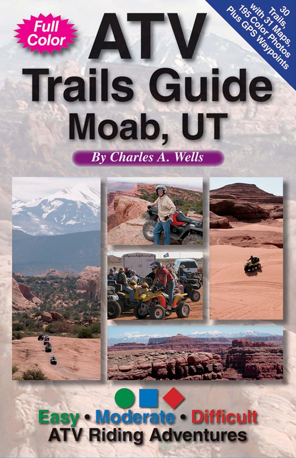
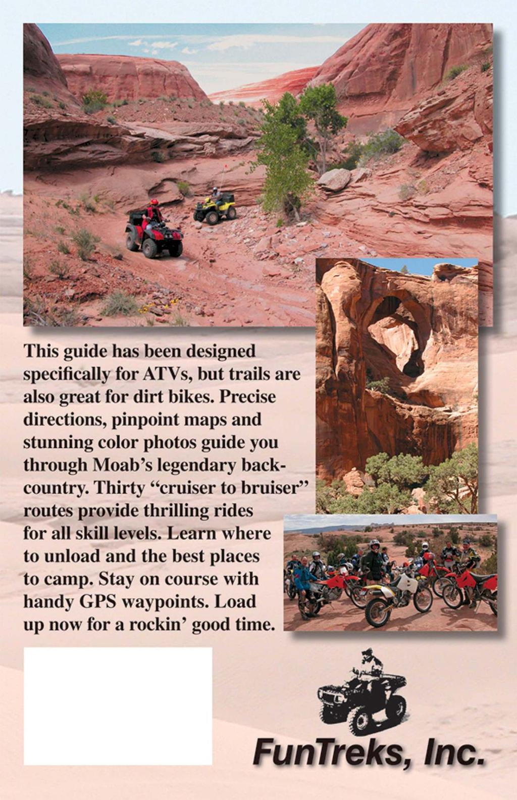
CONTENTS. 31 THE TRAILS See next page for a complete listing of all trails and a locator map. Trail descriptions begin on page 31.
|
|
|
- Britton Townsend
- 5 years ago
- Views:
Transcription
1

2 CONTENTS Page Topic 6 Trail List 7 Trail Locator Map 8 Trails Listed by Dificulty 9 Trail Ratings Deined 11 INTRODUCTION 11 Using this Book 12 The Right Trail for You 13 About Moab 15 Utah OHV Laws and Licensing Requirements 16 Safety Tips 18 Trip Preparation 18 Checklist of Equipment and Supplies 20 Your Responsibilities as a Backcountry Rider 24 Courtesy and Ethics 25 Riding on Slickrock 26 Route-Finding Tips 27 Global Positioning (& GPS Settings) 28 Desert Survival 29 Final Comments 30 Map Legend 31 THE TRAILS See next page for a complete listing of all trails and a locator map. Trail descriptions begin on page APPENDIX 154 References/Maps 155 Contact Information 158 About the Author 160 Order Form for Other FunTreks Books Kane Creek Canyon Rim, Trail #


3 Trail List Trail Locator Map No. Trail Page Rating 1. Crystal Geyser 32 Easy 2. White Wash Sand Dunes* 36 Moderate 3. Tenmile Wash 40 Moderate 4. Rainbow Terrace 44 Moderate 5. Dellenbaugh Tunnel, Secret Spire 48 Moderate 6. Hey Joe Canyon 52 Dificult 7. Determination Towers* 56 Moderate 8. Sevenmile Rim 60 Dificult 9. Sovereign Trail 64 Moderate 10. Gemini Bridges 68 Easy 11. Bull Canyon* 72 Easy 12. Poison Spider Mesa* 76 Dificult 13. Potash 80 Easy 14. Hurrah Pass* 84 Easy 15. Chicken Corners* 88 Easy 16. Kane Creek Canyon* 92 Dificult 17. Picture Frame Arch 96 Easy 18. Kane Creek Canyon Rim 100 Dificult 19. Dome Plateau* 104 Moderate 20. Pole Canyon Rim 108 Easy 21. Top of the World* 112 Dificult 22. Dolores Overlook 116 Easy 23. Onion Creek* 120 Easy 24. Fins & Things* 124 Dificult 25. Steelbender Loop 128 Dificult 26. La Sal Pass* 132 Moderate 27. Hideout Mesa 136 Moderate 28. Greasewood Canyon 140 Dificult 29. Cameo Cliffs/Wilson Arch* 144 Moderate 30. Cameo Cliffs/ El Diablo* 148 Dificult TO SALT LAKE CITY Green Green 70 Ruby Ranch 2 Tenmile Pt. Rd. Spring Cyn. Point Rd. Green Salt Lake City 3 6 UTAH Area Detailed Below 175 Crescent Junction Tenmile Point Dripping Springs 5 4 Levi Well Spring Cyn. Bottom Rd. CANYONLANDS NATIONAL PARK Dubinky Well 180 Blue Hills DEAD HORSE POINT STATE PARK Thompson Springs Mill Canyon ARCHES NATIONAL PARK Moab 128 to Behind the Rocks 202 Needles/ Anticline Overlook TO GRAND JUNCTION Dewey Bridge Kane Creek Easy Trails Moderate Trails Dificult Trails 128 Sand Flats Old Airport Top of long hill Castleton 114 Cisco La Sal Mtn. Loop Entrada Bluffs MANTI-LA SAL NATIONAL FOREST La Sal *Author s Favorites 6 7 N 0 miles 10 To Monticello
4 Trails Listed by Difficulty Although trails are grouped into three major categories, there are still differences in dificulty within each group. For example, Potash is easier than Pole Canyon Rim even though both are rated easy. Trails are progressively more dificult as you pan down the list, although you may have to skip several trails to see any signiicant difference. No. Trail Page Rating 13. Potash 80 Easy 23. Onion Creek 120 Easy 22. Dolores Overlook 116 Easy 10. Gemini Bridges 68 Easy 14. Hurrah Pass 84 Easy 17. Picture Frame Arch 96 Easy 15. Chicken Corners 88 Easy 11. Bull Canyon 72 Easy 1. Crystal Geyser 32 Easy 20. Pole Canyon Rim 108 Easy 2. White Wash Sand Dunes 36 Moderate 27. Hideout Mesa 136 Moderate 7. Determination Towers 56 Moderate 5. Dellenbaugh Tunnel, Secret Spire 48 Moderate 3. Tenmile Wash 40 Moderate 29. Cameo Cliffs/ Wilson Arch 144 Moderate 9. Sovereign Trail 64 Moderate 26. La Sal Pass 132 Moderate 4. Rainbow Terrace 44 Moderate 19. Dome Plateau 104 Moderate 8. Sevenmile Rim 60 Dificult 6. Hey Joe Canyon 52 Dificult 21. Top of the World 112 Dificult 30. Cameo Cliffs/ El Diablo 148 Dificult 18. Kane Creek Canyon Rim 100 Dificult 24. Fins & Things 124 Dificult 25. Steelbender Loop 128 Dificult 16. Kane Creek Canyon 92 Dificult 28. Greasewood Canyon 140 Dificult 12. Poison Spider Mesa 76 Dificult Trail Ratings Deined Trail ratings are very subjective. Conditions change for many reasons, including weather and time of year. An easy trail can quickly become dificult when washed out by a rainstorm or blocked by a fallen rock. You must be the inal judge of a trail s condition on the day you ride it. If any part of a trail is dificult, the entire trail is rated dificult. You may be able to ride a signiicant portion of a trail before reaching the dificult spot. Read each trail description carefully for speciic information. Turn around when in doubt. Always wear a helmet. Easy Trails Gravel, dirt, clay, sand, or mildly rocky trail or road. Gentle grades. Water levels low except during periods of heavy runoff. Adequate room to pass. Where shelf conditions exist, trail is wide and well maintained with minor sideways tilt. Most trails are passable when wet; however, certain types of clay can become impassable under wet conditions. Smaller, two-wheel-drive ATVs are usually adequate in good weather. Easy trails are best suited for novice riders. Moderate Trails Rougher and rockier surfaces require slower running speeds. Some riding experience is needed for steeper climbs and descents. Rock-stacking may be necessary to get over the worst spots. Considerable weight shifting may be necessary to offset sideways tilt. Mud can be deep and you may get stuck. Certain types of clay can become impassable when wet. Sand can be soft and steep. Water may be too deep for smaller ATVs. Larger ATVs can usually get through except during periods of heavy runoff. Aggressive tires needed for two-wheel-drive machines. Four-wheel-drive is usually best. Dificult Trails Very rough and rocky surfaces require careful tire placement. Slopes may be extremely steep with scary sideways tilt. Skillful riding is necessary to avoid tipping or lipping over. Rock-stacking may be necessary in places, and the worst spots could require assistance from other people. Sand can be very soft and steep. Shelf roads can be very narrow with daunting cliffs. Water and mud can be very deep. Wet clay surfaces can be impassable. Some powerful two-wheel-drive ATVs may get through under good weather conditions, but four-wheel-drive with low-range gearing is highly recommended. 8 9

 Staging/Camping: Unload at Waypoint 01 as stated above.")


5 Rocky terrain around Determination Towers. Pass through this rock opening after towers. A few steep climbs. Entering Tusher Tunnel. Determination Towers 7 Getting There: Drive north from Moab on Highway about 13 miles and turn left on Mill Canyon just after mile marker 141. Head west over railroad tracks and continue 0.7 miles to a broad intersection where Mill Canyon goes left to Cotter Mine. Staging is permitted in a wide area to the right of this intersection. (Ignore the irst parking area on the right just after the railroad tracks.) Staging/Camping: Unload at Waypoint 01 as stated above. You can also stage at the other end of Cotter Mine and reach the trail from the south side. This entry point is convenient to Archview C.G. Dificulty: Moderate rock ledges, soft sand and steep climbs. A complex network of roads can be confusing. Highlights: This route serves as an introduction to a broad, scenic area with many fun roads and dramatic rock formations, including Monitor and Merrimac Buttes and Determination Towers. An exciting side trip to Tusher Tunnel includes twisting sand trails and undulating terrain. Stay on existing roads at all times. No cross-country travel allowed. Time & Distance: About 15 miles as described here. Allow 3 to 4 hours. Add more time for other roads you ll want to explore. Trail Description: Climb rocky switchbacks to a high plateau. After a long straightaway across Courthouse Pasture, you ll turn north, then west past the eye-popping Determination Towers. Continue west downhill through twisting, sandy terrain to Tusher Wash. This wide, easy wash goes north toward Tusher Wash. Before you reach Tusher Wash, turn west to see interesting Tusher Tunnel, which requires a short, steep hike. Return to Tusher Wash where it connects to Tusher Wash, then head east back to start. Other routes nearby: Sevenmile Rim, Trail #8. Numerous other roads shown on map. Special Note: Trails through Mill Canyon and around Courthouse Rock are important mountain biking routes. Please stay out of this area. These routes may soon be closed to motorized trafic. Returning from Tusher Tunnel across sandy ridge to rejoin Tusher Wash. Services: Gas and supplies are available at Archview Campground at the intersection of Highways and. No toilets on trail


, bear left at fork as you come downhill.")
 1.7 Turn left at T. Right goes northeast to Tusher Wash. 09 2.0 N38 42.66 W109 46.96 Bear left at fork that is part of loop at base of Tusher Tunnel.")
 08 2.7/0.0 After returning to Wpt.")


6 Directions: (Shadowed portion of trail is described here.) WP Mile Action N W Head south on Cotter Mine. Stay left on main road past several roads that branch to right /0.0 N W Bear right uphill on 7-Mile. Switchbacks become rockier at top. 0.9 Bear right at fork after rocky switchback N W Turn right, leaving 7-Mile Rim Trail. 1.4 Continue straight on best road at major crossroads. bends southwest and heads directly towards Merrimac Butte. 2.4 Bear right at Y N W Make a hard right at major 5-way intersection and head due north N W Turn left towards Determination Towers. 4.7 Stay right of towers and pass through right side of rock opening. Descend through sandy, undulating area. Stay right. 5.9 Stay right as trail drops into narrow wash N W Trail runs into Tusher Wash. Turn right and follow wide wash. It soon passes through a narrow, wet section /0.0 N W To reach Tusher Tunnel, turn left uphill out of Tusher Wash on a steep trail. (Don t be confused by 7-Mile sign.) Straight goes directly to Tusher Wash in 0.8 miles. Right goes to a fun network of roads, one of which goes to a remote overlook of Mill Canyon. 1.2 After a series of steep hills (see photo), bear left at fork as you come downhill. Right goes back to Tusher Wash across a sandy ridge N W Continue straight uphill where four roads converge at bottom of sandy wash. (You ll return here later.) 1.7 Turn left at T. Right goes northeast to Tusher Wash N W Bear left at fork that is part of loop at base of Tusher Tunnel. Find sign and hike up steep path to tunnel entrance. After visiting tunnel, turn around and ride back to Waypoint 08. (Before doing this, you may wish to explore a fun area on the backside of tunnel. Follow road around rocks south of tunnel.) /0.0 After returning to Wpt. 08, bear left at bottom of wash and connect to sandy ridge that goes back to Tusher Wash /0.0 N W Drop into Tusher Wash and turn left to connect with Tusher Wash. Turn right on Tusher Wash, which soon crosses a wide part of Tusher Wash. 0.1 Turn right uphill out of Tusher Wash. Important turn is easy to miss Arrive back at start. To Blue Hills Grid size - 1 mile Tusher Tunnel Tusher Wash Sandy ridge 10 Steep hills Tusher Wash Sandy BLM LAND To Canyonlands National Park 2006 FunTreks, Inc. Power Line Determination Towers To I-70, Crescent Junction Merrimac Butte BLM LAND P MILL CANYON Monitor & Merrimac Biking Trail S Mill Canyon Start Here 01 Courthouse Pasture Monitor Butte P BLM LAND MINI KEY Paved Unpaved Easy Moderate Difficult More Trails Mill Canyon MM 141 Halfway Stage Station Cotter Mine Courthouse Rock Power Line SEVENMILE RIM Trail #8 N Determination Towers S P Archview C.G. S To Moab
7
Contents. Elephant Hill, Trail #53, Difficult.
 Page Topic 6 Trails Listed by Area 7 Trail Locator Map 8 Trails Listed by y, Ratings Defined 10 Trails Listed Alphabetically & Author s Favorites Contents 11 ITRODUCTIO 13 How to Use This Book 13 Selecting
MOAB peopleforbikes.org/e-bikes
 emtb ADVENTURE MAPS MOAB peopleforbikes.org/e-bikes OVERVIEW Moab, Utah is a world-class mountain bike destination known for its vast, red sandstone landscapes nestled below the rising peaks of the La
Arches of the. Sandflats Area. By Virginia Allen
 Arches of the Sandflats Area By Virginia Allen TABLE OF CONTENTS Introduction Dedication Road Log Arches 1. Perforated View Arch 2. Fee Booth Arch 3. Windsong Arch 4. Weird Arch 5. Resting Arch 6. Bike
MOAB Multi-Day (update ) RUN ANNOUNCEMENT
 RUN ANNOUNCEMENT") MOAB Multi-Day (update 02-06-18) RUN ANNOUNCEMENT RUN FULL NO MORE RSVPs ACCEPTED Date: March 31st to April 6th 2018 Trail Leader: Mike Wallace (714) 504-8514 Max Vehicle Limit Reached Meeting Tims: To
MOAB Multi-Day (update 02-06-18) RUN ANNOUNCEMENT RUN FULL NO MORE RSVPs ACCEPTED Date: March 31st to April 6th 2018 Trail Leader: Mike Wallace (714) 504-8514 Max Vehicle Limit Reached Meeting Tims: To
San Juan Hut Systems Telluride To Moab Route Description. Adventure without the weight
 San Juan Hut Systems Telluride To Moab Route Description Due to the inaccuracies caused by varying calibrations in odometers, you may notice some inaccuracies in the mileages listed for the Standard Route
Trail Phasing Plan. Note: Trails in the Clear Creek Canyon area (Segments will be finalized in the future to minimize wildlife impacts
 Note: Trails in the Clear Creek Canyon area (Segments 2 5 and a future JCOS connection) will be finalized in the future to minimize wildlife impacts Trail Phasing Plan P Parking 3 Easy Trail Intermediate
Telluride-to-Moab Alternative Singletrack Options
 Telluride-to-Moab Alternative Singletrack Options Day 1 Day 1 Alternate 1: Galloping Goose to Deep Creek. 18.4 miles, ascent 3,530ft, descent 1,388ft. This is fun, flowey, moderate to intermediate singletrack
(west) onto Charleston Boulevard. Drive 16 miles on Charleston and turn right into Red Rock
 onto Charleston Boulevard. Drive 16 miles on Charleston and turn right into Red Rock") Hike: North Peak and Ice Box Overlook up and back Trailhead: 2.5 miles up the Rocky Gap Road not mark Distance: 5 miles round trip Elevation gain: 2,694 feet Elevation Peak: 7,094 feet Time: 3 to 5 hours
Hike: North Peak and Ice Box Overlook up and back Trailhead: 2.5 miles up the Rocky Gap Road not mark Distance: 5 miles round trip Elevation gain: 2,694 feet Elevation Peak: 7,094 feet Time: 3 to 5 hours
Tiger Mountain State Forest:
 98 60 hikes within 60 miles: SEATTLE 20 Tiger Mountain State Forest: West Tiger Mountain Three Loop i KEY AT-A-GLANCE INFORMATION Length: 5.1 miles round-trip Configuration: Loop Difficulty: Moderate difficult
Hiking Las Vegas.com
 Hike: Mt. Wilson via First Creek Canyon route Trailhead: First Creek marked Distance: 10 miles up and back Elevation gain: 3,400 feet Elevation of Peak: 7,070 feet Time: 7 to 9 hours (up and back) Difficulty:
A Publication of Friends of Sleeping Bear Dunes
 A Publication of Friends of Sleeping Bear Dunes 2014, Friends of Sleeping Bear Dunes, P.O. Box 545, Empire, MI 49630 www.friendsofsleepingbear.org info@friendsofsleepingbear.org Learn more about the Friends
CIEC 9 PEAKS AWARD SUPPLEMENT POSSIBLE ROUTES FOR THE 9 PEAKS AWARD TRIP
 CIEC 9 PEAKS AWARD SUPPLEMENT POSSIBLE ROUTES FOR THE 9 PEAKS AWARD TRIP As you plan your trip, be aware of 3 regulations in this wilderness: 1. Camp only in designated campsites. 2. No campfires allowed.
San Juan Hut Systems Durango to Moab Route Description
 San Juan Hut Systems Durango to Moab Route Description Adventure Without The Weight Using the Daily Route Description: Due to varying calibrations in odometer, riders may notice some inaccuracies in the
HORSEBACK RIDING. All rates are subject to service charges
 HORSEBACK RIDING The Local Loop Ride - A family-friendly 45-minutes to one hour ride around Dunton s east property. Perfect for children and adults who are new to riding. Easy terrain and beautiful views.
Leaden Boot Challenge ROUTE INSTRUCTIONS
 Leaden Boot Challenge ROUTE INSTRUCTIONS Section 1 Alstonefield to Ilam From the village hall car park turn R then L and pass through the village keeping to the R to enter Church Street. Pass the Church
ATACAMA CROSSING 2008 COURSE HANDBOOK STAGE 1. CP1 CP2 CP3 CP4 camp 2 Total Difficult Moderate Moderate km km 8.38 miles. 7.
 Camp 1: Rock Carvings Camp 2: Inca (On the edge of the slot canyons) 1: Navigation by Rock Altitude, rolling hills, flat out landscape. CP2 and Piedra de los cocas hieroglyphs Inca influence - side of
Manti-La Sal National Forest Mountain Bike Trails
 Manti-La Sal National Forest Mountain Bike Trails Trail Name Miles Kilometers Trail Difficulty Rating MTB Project Ranking System New Mexico National Abajo Loop 14.1 22.7 Difficult 2.5 1 127 3,167 Aspen
UTAH 2016 CANYONLANDS
 UTAH 2016 CANYONLANDS THE WHITE RIM TRAIL MAY 17, 2016 We left the cabin at 7:30 a.m. The goal was to get to Great Basin National Park that night. We took Highway 6 towards Tonopah and decided to go north
GOLDEN EARS PROVINCIAL PARK
 GOLDEN EARS PROVINCIAL PARK Trail Information as of October 10 th 2015 Do not underestimate the mountainous wilderness of Golden Ears Provincial Park. The combination of rugged terrain and rapidly changing
Little Grand Canyon near Pomona, Illinois
 Little Grand Canyon near Pomona, Illinois Below: View of the trail and the terrain created using the Map My Hike app Below: Summary of the hike created using the Map My Hike app Presented by: Jennifer
BRYCE CANYON COUNTRY Boulder Mountain Scenic backways itinerary
 BRYCE CANYON COUNTRY Boulder Mountain Scenic backways itinerary Boulder Mountain Area The high plateaus of the Aquarius Plateau (Boulder Mountain), are heavily forested and covered in countless winding
Hiking Las Vegas.com
 Hike: Juniper Peak up and back Trailhead: Oak Creek Canyon marked Distance: 5.5 miles round trip Elevation gain: 2,200 feet Elevation peak: 6,109 feet Time: 4 to 5 hours - Up and back Difficulty: 3 Danger
Southern Utah University Hike Brochure
 Southern Utah University Hike Brochure Taylor Creek Trail Twenty minutes from Cedar City Red Hollow An hour and a half from Cedar City Fees: Entrance fee to Kolb Canyon Length: 5 miles round trip Length:
Black Hill Regional Park, Little Seneca Lake
 Black Hill Regional Park, ittle Seneca ake ittle Seneca ake, in Black Hill Regional Park, is a reservoir created after a previous drought struck the Washington area. The park is under Maryland-National
Trail Beginning Elevation: 7553 ft The Poison Creek Trailhead is located at the end of National Forest Road 646E (NF-646E).
.") West Mountain Trails Poison Creek Trail #134 Length: 2.9 miles (4.7 km) Difficulty Horseback: A good trail for the first time west mountain rider, some steep sections Hiking: Most Difficult USGS Maps:
West Mountain Trails Poison Creek Trail #134 Length: 2.9 miles (4.7 km) Difficulty Horseback: A good trail for the first time west mountain rider, some steep sections Hiking: Most Difficult USGS Maps:
San Luis Obispo. Bishop Peak Felsman Loop Eagle Rock Maino Open Space Poly Canyon Poly P Other Areas
 San Luis Obispo Bishop Peak Felsman Loop Eagle Rock Maino Open Space Poly Canyon Poly P Other Areas 1 JCT. ELEV. 72 400 00 0 FELSMAN LOOP GATE LOOP RIDGE 600 FENCE JCT. ELEV. 860 1000 1200 BISHOP PEAK
Crystal Lake Area Trails
 Lake Area Trails Welcome to the Lake area of the Big Snowy Mountains! This island mountain range in central Montana features peaks reaching to 8,600 feet and long, high ridges from which vistas of the
NATIONAL ATV / UTV JAMBOREE RIDES
 NATIONAL ATV / UTV JAMBOREE RIDES Note: Rides range from Beginner to Advanced and will last from 2 to 3 hours or an entire day of riding. 1. DESERT RIDE (CLEAR LAKE BIRD REFUGE & LACE CURTAINS/LAVA TUBES)
Slad over to Pitchcombe and back
 The walk climbs up from Slad over Wickridge Hill, descends to near Pitchcombe, then climbs back over Wickridge hill and round the back of Slad. Page 1 Start Point: SO 8718 0732 The Woolpack, Slad Length:
Leaden Boot Challenge 2016 ROUTE INSTRUCTIONS
 Leaden Boot Challenge 2016 ROUTE INSTRUCTIONS Section 1 Alstonefield to Ilam (CP2) From the village hall car park turn R then L and pass through the village keeping to the R to enter Church Street. Pass
NATIONAL ATV / UTV JAMBOREE RIDES
 NATIONAL ATV / UTV JAMBOREE RIDES Note: Rides range from Beginner to Advanced and will last from 2 to 3 hours or an entire day of riding. 1. DESERT RIDE (CLEAR LAKE BIRD REFUGE & LACE CURTAINS/LAVA TUBES)
DESERT SOLITAIRE. Pinnaclemag.com
 DESERT SOLITAIRE Inconvenient and remote, Moab, Utah is an oft-overlooked gem for true wilderness enthusiasts. Despite its renowned Slickrock Trail and its close proximity to two national parks, Moab remains
CAMELBACK MOUNTAIN: CHOLLA TRAIL
 CITY OF PHOENIX :: Camelback Mountain: Cholla T rail 21 CAMELBACK MOUNTAIN: CHOLLA TRAIL IN BRIEF Camelback Mountain is the tallest point in the city of Phoenix. From the 2,704-foot summit of Camelback,
C E N T R A L C A T S K I L L S
 120 C E N T R A L C A T S K I L L S Central Catskills Once out of the southern parts of the Catskills, the Long Path enters the more well traveled and civilized regions. The trail joins the Devil s Path,
playwinterpark.com Off The Beaten Path Hikes Hiking Recommendations for the Adventurous Hiker
 playwinterpark.com Off The Beaten Path Hikes Hiking Recommendations for the Adventurous Hiker Hike: Devil s Thumb (difficult) Length: 3.93 miles one-way Elevation: Trailhead 9609 Destination 12,236 Trailhead
Skiing and Snowshoes on Un-groomed Fernan Saddle Terrain
 Skiing and Snowshoes on Un-groomed Fernan Saddle Terrain Three ski or snowshoe routes are available from the Fernan Saddle Parking Lot which either do not cover routes ordinarily groomed for snow machine
ELEPHANT BUTTE LAND 640 Acres of pristine land surrounded by BLM property Next to Coral Pink Sand Dune Area Southern Utah INVESTMENT OFFERING
 640 Acres of pristine land surrounded by BLM property Next to Coral Pink Sand Dune Area Southern Utah PROPERTY DESCRIPTION Nestled within one of Southern Utah s picturesque red cliff valleys, with spectacular
Other Agencies and Organizations
 Daniel Boone National Forest 1700 Bypass Road WInchester, KY 40391 859-745-3100 Location Northern terminus is near Morehead, Kentucky. Southern terminus is located in the Big South Fork NRRA in Tennessee.
Below is an example of a well laid-out template of a route card used by the Sionnach Team which is a good format to begin with.
 Route Card A route card is used as a navigational aid to hill walkers by setting out a step by step plan for an intended hike. It is good practice to make out a route card before every hike you or your
Drive and Stop Routes
 Drive and Stop Routes Limantour Road 1 - easy and likely productive. From Bear Valley Visitor Center drive back out and turn left onto Bear Valley Rd. Turn left at Limantour Road (the first road). Drive
GIFFORD PINCHOT NATIONAL FOREST
 GIFFORD PINCHOT NATIONAL FOREST 9341 Wright Meadow 93 Spencer Meadow Spencer Butte 4247' 30 30A 19 24 80 31C Lewis River Lower Falls 5 Quartz Creek 90 Taidnapam Falls Upper Falls 31 Spencer Peak 3861'
Bryce Canyon Country.
 Bryce Canyon Country Backways Itinerary - Grand Staircase, Capitol Reef Region Grand Staircase/Capitol Reef/Henry Mountains Adventure off the beaten path and revel in the beauty of Utah s scenic backways.
Berowra Waters to Cowan Station
 Berowra Waters to Cowan Station 3 hrs 30 mins 7.2 km One way Hard track 597m This is a hilly walk out of the beautiful Berowra Waters valley to Cowan Station. There are many wide views across Berowra Creek
Stephens State Park Trails
 TRAILS OF ALLAMUCHY MOUNTAIN & STEPHENS STATE PARKS Allamuchy Mountain and Stephens State Parks contain 28 marked trails providing access to diverse landscapes for walking, hiking, biking, bird-watching,
Route #2) Mt. Massive - Southwest Slopes
 Mt. Massive - Southwest Slopes") Route #2) Mt. Massive - Southwest Slopes Difficulty: Class 2 Ski: Advanced, D6 / R2 / III Exposure: Summit Elevation: Trailhead Elevation: Elevation Gain: Round-trip Length: Trailhead: County Sheriff:
Route #2) Mt. Massive - Southwest Slopes Difficulty: Class 2 Ski: Advanced, D6 / R2 / III Exposure: Summit Elevation: Trailhead Elevation: Elevation Gain: Round-trip Length: Trailhead: County Sheriff:
UTAH S NATIONAL PARK TOUR
 UTAH S NATIONAL PARK TOUR DAY 1 Each client needs to check in any time at the fabulous Aria Hotel located in the heart of Las Vegas. We will meet at 6pm for a one hour orientation explaining the schedule
A DESERT CAMPING GUIDE FOR ANZA BORREGO DESERT STATE PARK
 A DESERT CAMPING GUIDE FOR ANZA BORREGO DESERT STATE PARK With over 500,000 acres of beautiful terrain, Anza Borrego Desert State Park offers endless opportunities for Boy Scout Troops, Venture Crews and
Durango. Durango Whitewater Park
 High Adventure Along Colorado s Million Dollar Highway Durango If you re looking for a multi-day trip of Jaw-dropping adventure in the Colorado mountains look no further! This guide outlays 4 days through
BRYCE CANYON COUNTRY. A twisted tree endures rugged life on the rim of the Paunsaugunt Plateau.
 BRYCE CANYON COUNTRY Grand Staircase - Paunsaugunt Plateau Scenic backways itinerary A twisted tree endures rugged life on the rim of the Paunsaugunt Plateau. Travel to Bryce Canyon Country. Lodging check-in,
Route #1) Mt. of the Holy Cross - North Ridge
 Mt. of the Holy Cross - North Ridge") Climbing 14ers can be very dangerous, please read the Mountaineering Safety Page and make sure you have a map+compass and can use them effectively, without the help of electronic devices. Route #1) Mt.
Climbing 14ers can be very dangerous, please read the Mountaineering Safety Page and make sure you have a map+compass and can use them effectively, without the help of electronic devices. Route #1) Mt.
Rock Creek Park, MD - Lake Needwood
 ock Creek Park, MD - Lake Needwood Lake Needwood, is a reservoir located at the end of the north end of the ock Creek hiker-biker trail. At the other end, ock Creek empties into the Potomac iver near Thompson
Internet TripTik. From : Zion National Park, Ut Stop At Stop At Stop At Stop At Stop At. : Bryce Canyon National Park, Ut : Arches National Park, Ut
 MAP: Overview Internet TripTik From : Zion National Stop At Stop At Stop At Stop At Stop At To : Bryce Canyon National Park, Ut : Arches National : Canyonlands National : Monument Valley, Utah : Kayenta,
Note: Coordinates are provided as Universal Transverse Mercator UTM Zone U21, North American Datum 1983 (NAD 83).
.") Northern Traverse Route Description The Northern Traverse (formerly the North Rim Traverse) is an unmarked and rugged backcountry hiking route. It is known be a demanding hike, because of its terrain and
Northern Traverse Route Description The Northern Traverse (formerly the North Rim Traverse) is an unmarked and rugged backcountry hiking route. It is known be a demanding hike, because of its terrain and
Section 7: Pick Up Where You Left Off! S-Tree Road over the Todd Road
 2018 TRACE NOTES Helpful information for your adventure on Section 7 of the Hiker Challenge. Start Point S-Tree Rd. End Point Intersection Todd Rd. / Hale Ridge Rd. WEATHER DECISION Weather Alert!!!! Potential
beach. Make the ford and follow the trail out to the junction with Red Creek Tr in an open grassy area.
 Description: This is a moderate to slightly strenuous 22.8 mile backpack (add 2.6 miles if you do the packless out and back to the Lion s Head) that will have you exploring nearly every thing that is The
FLY FISHING. Half Day $400 for one person -or- $275 per person for 2+ people Full Day $550 for one person -or- $350 per person for 2+ people
 FLY FISHING Enjoy classic western fly fishing on the West Fork of the Dolores River. Both the Dunton Hot Springs and Dunton River Camp offer anglers a combination of meadow oxbows and pocket water canyons.
YOSEMITE ON HORSEBACK: THREE RIDES ALONG TIOGA ROAD Cindy Casey White Wolf Area, May Lake Loop, Ragged Peak Loop
 YOSEMITE ON HORSEBACK: THREE RIDES ALONG TIOGA ROAD Cindy Casey White Wolf Area, May Lake Loop, Ragged Peak Loop The high country along Tioga Road presents us with some of the most dramatic scenery in
Self-Guided Walk Langdale Pikes. Start & Finish: NT car park (free to members) at Sticklebarn - on the right just beyond the New Dungeon Ghyll hotel.
 at Sticklebarn - on the right just beyond the New Dungeon Ghyll hotel.") Self-Guided Walk Langdale Pikes Key Information These mountains form a collection of spires and cliffs on the north side of Langdale. This walk visits four of the main tops Pavey Ark, Harrison Stickle,
Self-Guided Walk Langdale Pikes Key Information These mountains form a collection of spires and cliffs on the north side of Langdale. This walk visits four of the main tops Pavey Ark, Harrison Stickle,
Hiking Trail Descriptions
 Hiking Trail Descriptions For ye shall go out with joy. And be led forth with peace. The mountains and the hills shall break forth before you in singing. And all the trees of the fields shall clap their
GUIDED HIKING. Cancellation Policy. Cancellations within 72 hours of the scheduled activity will result in full payment
 GUIDED HIKING Hiking around Dunton and the beautiful San Juan Mountains, is the quintessential wilderness experience. You ll walk through exquisite high alpine basins blanketed in wildflowers amidst high
Rogue Gorge (Mt. Stella) Roadless Area-- T30S R3E (primarily in portions of Sections 23, 26, 33, 34 & 35)
 Roadless Area-- T30S R3E (primarily in portions of Sections 23, 26, 33, 34 & 35)") Rogue Gorge (Mt. Stella) Roadless Area-- T30S R3E (primarily in portions of Sections 23, 26, 33, 34 & 35) Rogue River-Siskiyou National Forest--High Cascades Ranger District Upper, higher elevation trail
Rogue Gorge (Mt. Stella) Roadless Area-- T30S R3E (primarily in portions of Sections 23, 26, 33, 34 & 35) Rogue River-Siskiyou National Forest--High Cascades Ranger District Upper, higher elevation trail
Colorado s forests are slated to lose thousands of miles of roads through the new OHV Route Designation process. DON T LET IT HAPPEN!
 Colorado s forests are slated to lose thousands of miles of roads through the new OHV Route Designation process. DON T LET IT HAPPEN! This packet identifies many roads that you may lose if you don t act.
TREK TO ANCIENT PETRA
 JORDAN TREK DEMANDING ABOUT THE CHALLENGE This challenging and adventurous trek takes us through unique landscapes in one of the friendliest countries in the world, ending at the impressive rock-hewn facades
Page Topic. 4 Trail List 5 Trail Finder 6 Trail Ratings Deined 6 Author s Vehicles
 Published by FunTreks, Inc. P.O. Box 3127, Monument, CO 80132-3127 Phone: Toll free 877-222-7623 Fax: (719) 277-7411 E-mail: books@funtreks.com Web site: www.funtreks.com Copyright 2011 by FunTreks, Inc.
GUIDED HIKING. *Guests need to bring seasonally appropriate layers, hat, sun glasses, water bottle and sunscreen. Cancellation Policy
 GUIDED HIKING Hiking around Dunton into the beautiful San Juan Mountains is the quintessential wilderness experience. Trails lead you through exquisite high alpine basins blanketed in wildflowers amidst
Baggy Point, Croyde, North Devon
 Baggy Point, Croyde, North Devon A walk using the South West Coast Path that is likely to be suitable for people with impaired mobility or with a pushchair, wheelchair, or mobility scooter. The Coast Path
COURSE DESCRIPTION AND DIRECTIONS
 COURSE DESCRIPTION AND DIRECTIONS START TO BOUNTIFUL B (MILE 0 to MILE 17.05) From the start at East Mountain Wilderness Park, go past the green metal gate of East Mountain Wilderness Park and follow the
CIRCLE THE AMERICAN WEST
 CIRCLE THE AMERICAN WEST 15 Day Tour from Denver to Denver May 31- June 14, 2019 Mother Nature has loaded the West with stunning scenery, and on this National Parks tour, you ll witness some of natures
Staunton River Trail to Hoover Camp and Fork Mtn. Relay Tower (Based on September 18, 2013 hike by Ron Singleton, Fredericksburg, Va.
 Staunton River Trail to Hoover Camp and Fork Mtn. Relay Tower (Based on September 18, 2013 hike by Ron Singleton, Fredericksburg, Va.) The President's Cabin (The "Brown" House) at Camp Hoover. Sign on
Canyons of South-Western USA
 Canyons of South-Western USA The canyon is calling and I must follow... 30 April to 19 May 2018 29 April to 18 May 2019 Trip Length: 20 days / nights Minimum 6 guests / Maximum 11 guests (Maximum numbers
TUPPER DESIGNATED ACCESS ROUTE
 TUPPER DESIGNATED ACCESS ROUTE 1 FOR ACCESS/EGRESS TO CONNAUGHT, LOOKOUT, STONE ARCH, PORTAL PATHS AND TUPPER TRAVERSE EGRESS Length: 2.6km Vertical Gain: +162m / -83m (Values are for access. For egress,
ROAD SCHOLAR SPRING HIKING ADVENTURE Tentative Schedule April 9-14, 2017
 ROAD SCHOLAR SPRING HIKING ADVENTURE Tentative Schedule April 9-14, 2017 Sunday, April 9 PM 3:00-5:00 Arrival, registration and move in to the dorm. 6:00 Supper EVE 7:15 Welcome & Orientation, Sign Ups
Beaver Creek State Park
 GENERAL INFORMATION Name of Park/Forest/Facility: Beaver Creek State Park County: Columbiana (St. Clair Township) Address: 12816 Sprucevale Road (ie County Rd 428) (street #, city) East Liverpool, Ohio
Royal Gorge Far Out Trail to Le Point
 Royal Gorge Far Out Trail to Le Point Direction to trailhead: From East Ridge Campground: Drive west from Canon City on US 50 to County Road 3A, the entrance road to the Royal Gorge Park. Turn left onto
THE NATIONAL PARKS V 8 TOUR
 THE NATIONAL PARKS V 8 TOUR This National Tour will visit the spectacular red rocks and canyon country of Western Colorado and Eastern Utah, with a few high mountains thrown in for additional flavor. The
National Parks and Beyond
 National Parks and Beyond Canyons, Mesas and Hoodoos Nevada Utah Arizona Red Rock Canyon National Conservation Area Las Vegas, Nevada Begin your adventure under the neon lights of Las Vegas, an oasis in
Non-motorized Trail Plan & Proposal. August 8, 2014
 Town of Star Valley Ranch, Wyoming and the Star Valley Ranch Association in partnership with the USDA Forest Service, Bridger-Teton National Forest, Greys River Ranger District Non-motorized Trail Plan
INTERMEDIATE. mayorsmtbchallenge.org
 mayorsmtbchallenge.org Redding s second local Mountain Bike Challenge uniting current and new bicyclists in a friendly self-competition highlighting our diverse trail system. INTERMEDIATE Mule Ridge Cosmos
Hole in the Rock Scenic Backway
 Hole in the Rock Scenic Backway The Hole in the Rock Scenic Backway leads one along the pioneer path created by a Mormon Expedition. Approximately 55 miles one-way from Highway 12 to the Hole-inthe-Rock,
Beaver Country Trails ATV Jamboree
 Beaver Country Trails ATV Jamboree #1 Lincoln Mine Intermediate (Open to all ATVs/UTVs) 34 Miles Highlights: This ride will highlight the historic Lincoln Mining District, the first lead mine in Utah,
Cr./Left Fork of Boulder Creek/Horse Creek Made it 2.2 miles from Hwy on Left fork of Boulder Creek. Heavy washout;
 Road Inspector Inspection Inspection Date North Fork Mark M. 6/7 Open Boulder Cr. Helitack 6/16 no signs on either section of Boulder Cr. 2) we were able to make it to the creek crossing on Boulder Cr.
The Mendip Way. Route Directions and Maps Uphill to Wells
 The Mendip Way Route Directions and Maps Uphill to Wells Website: www.mendiphillsaonb.org.uk Email: mendip@mendiphillsaonb.org.uk Facebook & Twitter: @MendipHillsAONB Phone: 01761462338 1 Uphill to Loxton
LOWER SPRING CANYON - CAPITOL REEF
 LOWER SPRING CANYON - CAPITOL REEF Rating: Moderate Hike Length: 5-7 hours (10-11 miles) Gear: Standard Hiking Gear Maps: Fruita, UT; Twin Rocks, UT; Water: A filterable spring a bit over 1/2 way. Recommend
Mazatzal Wilderness Trail Maintenance and Exploration
 Mazatzal Wilderness Trail Maintenance and Exploration March 15-19 (Wednesday - Sunday) Difficulty: Beginner Camping: Car Camping Mileage: Wednesday ~4 miles Thursday ~4-6 miles Friday ~4-6 miles Saturday
Mt Kuring-gai Track to Berowra station
 Mt Kuring-gai Track to Berowra station 4 hrs 15 mins 9.7 km One way Hard track 4 553m This walk explores three valleys, with great displays of wild flowers in spring, and some nice sandstone overhangs.
JOIN USTO TOURDRAMATIC DESERT LANDSCAPESTHATHAVEBEEN MILLIONS OFYEARSIN THEMAKING
 JOIN USTO TOURDRAMATIC DESERT LANDSCAPESTHATHAVEBEEN MILLIONS OFYEARSIN THEMAKING SEPTEMBER10-21,2018 TOUR FEATURES 11 night's accommodations including Las Vegas (1), Bryce Canyon (1), Moab (3), Page (3),
Lake Wissota Access Locations within the LaFayette Township. By Chad Martin
 Lake Wissota Access Locations within the LaFayette Township By Chad Martin Anson/ Wissota Access Point # 1 Road: 195 th St. Associated Fire Numbers: 13294 Defining Characteristics: Forested from road
MOUNTAIN BIKING THE CASCADE LOOP
 MOUNTAIN BIKING THE CASCADE LOOP By Henry Freimuth All photographs by Henry Freimuth The Cascades are on the Spanish Creek, which is a tributary of the Feather River. The Feather River was named by Spanish
ANGEL PEAK SCENIC AREA
 Activities: Facilities: ANGEL PEAK SCENIC AREA Hiking, photography, watchable wildlife, camping, picnicking. Note: While formal hiking trails in the area are limited, dispersed hiking opportunities abound
Zion National Park/Gooseberry Weekend
 WATCH THE VIDEO Zion National Park/Gooseberry Weekend LENGTH: 3 Days / 2 Nights ACCOMMODATIONS: Camping FITNESS LEVEL: Intermediate For up-to-date pricing and dates, please visit our website. This fun-filled
Victoria Falls Lookout to Blue Gum Forest
 Victoria Falls Lookout to Blue Gum Forest 8 hrs Experienced only 13.8 km One way 5 112m This long day-walk follows a remote track down from Victoria Falls lookout, passing the waterfall, and into the Grose
Cannon Traverse via Lonesome Lake - Hi Cannon - Kinsman Ridge
 AMC April 28, 2010 Cannon Traverse via Lonesome Lake - Hi Cannon - Kinsman Ridge 0 1673 ft 2007, Appalachian Mountain Club. All rights reserved. Notes Created by AMC White Mountain Guide Online wmgonline.org
Whiteside Mountain Land Owned by: Location: Trails:
 Whiteside Mountain Latitude: 35 05.123 N Longitude: 083 07.933 W Elevation: 1,503m Land Owned by: US Forest Service Nantahala Ranger District 828-524-6441 Location: Jackson County, NC Turn off of US Highway
Griffith Park Trail Run Trail Guide Click for
 The Griffith Park Trail Run by Hike- LosAngeles.com Griffith Park Trail Run Trail Guide Click for downloadable cell phone guide and map from EveryTrail. DISTANCE: 4.55 Miles ELEVATION: 1280' ELEVATION
Trail Assessment Report
 Trail Assessment Report Trail Options for the Bear Creek Canyon located in Pikes Peak Ranger District, Pike National Forest and on Colorado Springs Utility Lands Due to the presence of a unique species
Bryce Canyon Country ATV Multi-Day Itinerary
 Bryce Canyon Country ATV Multi-Day Itinerary Look for more trail information and maps on these web-sites listed below. www. Casto Canyon Kick off your ATV adventure with this 36 mile round-trip ride through
Blue Ridge Hiking Club - First Quarter 2018 Hikes
 Blue Ridge Hiking Club - First Quarter 2018 Hikes Monday, Jan 1: Trout Lake to Manor House & Figure 8 Trail: Meet at Trout Lake parking lot, at 9:30. (1st exit left off Parkway just south of Cone Manor
San Miguel to Caserio de la Hoya Circular (San Miguel)
") Tenerife Sur: Short Walks Under 10 km San Miguel to Caserio de la Hoya Circular (San Miguel) Route Summary An informative and scenic walk back in time from San Miguel to below El Roque, overlooking the
Tenerife Sur: Short Walks Under 10 km San Miguel to Caserio de la Hoya Circular (San Miguel) Route Summary An informative and scenic walk back in time from San Miguel to below El Roque, overlooking the
Piestewa Peak/Dreamy Draw Trail Guide
 Piestewa Peak/Dreamy Draw Trail Guide Trail #1A - Perl Charles Memorial Trail Length: 4.8 miles Elevation: 2,200 ft. - 1,340 ft. Difficulty: Moderate to difficult The Perl Charles trailhead is located
HIKING/BIKING IN MERRITT AREA
 HIKING/BIKING IN MERRITT AREA Coquihalla Lakes: Just inside the southern boundary of BC Park's Coquihalla Summit Park, a nice little twin lakes paddle with a private campground & lodge is the Coquihalla