GLACIATED VALLEY LANDSYSTEMS
|
|
|
- Aubrey Wright
- 6 years ago
- Views:
Transcription
1 15-Evans-Glacial-15-ppp 5/27/03 2:38 PM Page 372 CHAPTER 15 GLACIATED VALLEY LANDSYSTEMS Douglas I. Benn, Martin P. Kirkbride, Lewis A. Owen and Vanessa Brazier 15.1 INTRODUCTION The concept of the glaciated valley landsystem was introduced by Boulton and Eyles (1979) and Eyles (1983b), to describe the characteristic sediments and landforms associated with valley glaciers in upland and mountain environments. By focusing on the scale of the whole depositional basin, the glaciated valley landsystem has a broader compass than most of the other landsystems explored in this book, which are specific to particular depositional environments. Indeed, glaciated valley landsystems may incorporate ice-marginal, supraglacial, subglacial, proglacial, periglacial and paraglacial landsystems, recording the juxtaposition and migration of very different depositional environments. Additionally, because glaciated valleys occur in every latitudinal environment from equatorial to polar regions, the dimensions of climate and glacial thermal regime add even more variability. Thus the glaciated valley landsystem should be regarded as a family of landsystems, which exhibits considerably more variety than suggested by the original Boulton and Eyles model (Fig. 15.1). Despite this variability, landsystems in glaciated valleys tend to have certain recurrent features, as a result of two main factors: 1. the strong influence of topography on glacier morphology, sediment transport paths and depositional basins 2. the importance of debris from supraglacial sources in the glacial sediment budget. In this chapter, we emphasise the contrasts between glaciers with limited supraglacial debris ( clean glaciers ) and glaciers with substantial debris covers in their ablation zones ( debriscovered glaciers ), although it should be recognized that intermediate forms occur between these end members. Before examining the landsystems of glaciated valleys, we begin by considering debris sources and transport pathways through valley glaciers, and the ways in which debris cover influences glacier dynamics.
2 15-Evans-Glacial-15-ppp 5/27/03 2:38 PM Page 373 GLACIATED VALLEY LANDSYSTEMS SEDIMENT SOURCES Processes delivering debris to glacier surfaces include debris flows, snow avalanches, rockfalls, and rock avalanches (Gordon and Birnie, 1986). In tectonically active regions, earthquakegenerated rock avalanches are significant (Post, 1964; Hewitt, 1988), but many rock avalanches have no obvious trigger (Gordon et al., 1978; McSaveney, 1992). The input of debris to glacier surfaces by mass movement processes is partly controlled by catchment topography, which determines the gradient, area and distribution of debris source areas. Additionally, bedrock lithology can introduce contrasts in supraglacial debris supply between otherwise similar catchments. For example, granite batholiths overlooking the Baltoro Glacier (Karakoram Mountains) yield little debris, whereas fissile sedimentary rocks in the same region are associated with high debris supply. The importance of the relative rates of debris and snow/ice delivery to the glacier surface is often overlooked. Glaciers with high debris concentrations tend to occur where rockfall rates are high and/or snowfall is low. For example, on the main Himalayan chain in Nepal, where precipitation is low ( 500 mm year 1 ) and the rapid uplift of young sedimentary rocks and extreme topography encourages very high rates of rockfall delivery to glacier surfaces, the majority of glaciers have debris-mantled ablation zones, and rock glaciers are widespread (Müller, 1980). In contrast, in western Norway, where crystalline rocks yield low rockfall rates, and precipitation is in the range 2,000 3,000 mm year 1, glaciers have little or no surface debris and rock glaciers are absent SEDIMENT TRANSPORT PATHWAYS Transport routeways through valley glaciers are varied (Fig. 15.2). Boulton (1978) distinguished two main sediment transport pathways: 1. active subglacial transport, and 2. passive supraglacial or englacial transport. Subglacial debris transport was termed active because sediment in the basal shear zone of glaciers is subjected to high inter-particle contact forces and consequently undergoes significant abrasion, fracture and comminution. Boulton (1978) argued that, in contrast, sediment in higher-level transport undergoes little modification and thus retains the characteristics of the parent debris. While this distinction is a useful one (e.g. Vere and Benn, 1989; Benn and Ballantyne, 1994), it is an oversimplification because supraglacial transport is not always passive. Boulders may undergo edge-rounding as debris is redistributed by ablation of the underlying ice (Benn and Evans, 1998; Owen et al., submitted). Glacifluvial processes were overlooked in Boulton s classification, though they may transport large amounts of sediment over, beneath and through many valley glaciers. Glacifluvial transport is particularly important on low-gradient glaciers with extensive debris cover, where reservoirs of sediment can be accessed by meltwater (Kirkbride and Spedding, 1996; Spedding, 2000). Subglacial conduits can entrain sediment from the glacier bed, and englacial conduits collect debris by wall melting. Glacifluvial sediment can then be delivered to the supraglacial transport zone where conduits emerge at the surface, or following conduit closure or freezing and debris melt-out. Fluvially rounded cobbles and sorted sand occur in the debris covers of New Zealand valley glaciers, Ngozumpa Glacier (Nepal) and other glaciers. Such facies
3 15-Evans-Glacial-15-ppp 5/27/03 2:38 PM Page 374 (A) (B)
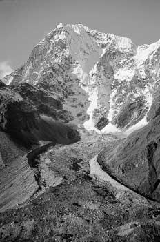
 Chola Glacier, a debris-covered glacier in the Khumbu Himal. Note avalanche cones below the headwall, and large lateral moraines.")
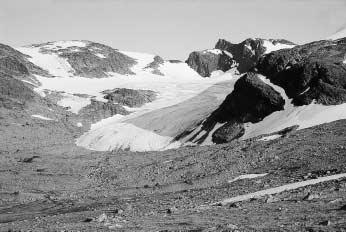
4 15-Evans-Glacial-15-ppp 5/27/03 2:38 PM Page 375 GLACIATED VALLEY LANDSYSTEMS 375 (C) Figure Three examples of mountain glaciers, showing the diversity of glaciated valley landsystems. A) Chola Glacier, a debris-covered glacier in the Khumbu Himal. Note avalanche cones below the headwall, and large lateral moraines. B) Slettmarkbreen, a cirque glacier with little supraglacial debris, Jotunheimen, Norway. C) Un-named hanging glacier and reconstituted lower tongue, Lahul Himalaya. Note avalanche track leading to the lower glacier, and dissected moraines at lower right. probably represent a tiny fraction of the debris flushed out of such glaciers during the ablation season, which is supplied directly to the proglacial outwash system (Kirkbride, 2002). In terms of sediment discharge, the apparent dominance of supraglacial debris is misleading, because the supraglacial load represents an inefficient pathway. Englacial and supraglacial fluvial pathways, although rarely observed, may dominate landsystem development at the termini of large debriscovered glaciers, as shown by the volume of Holocene outwash valley fills, many orders of magnitude greater than the volume of Holocene ice-marginal moraines. Debris passes between transport pathways by several processes, including melt-out, burial by snow, and ingestion by crevasses. In high-relief terrain, steep icefalls above low-gradient
5 15-Evans-Glacial-15-ppp 5/27/03 2:38 PM Page GLACIAL LANDSYSTEMS Figure Debris transport paths in a valley glacier. 1 = burial of rockfall debris in accumulation area, 2 = englacial transport and melt-out in ablation area, 3 = basal traction zone, 4 = suspension zone, 5 = basal till (may undergo deformation), 6 = elevated debris septum below glacier confluence, 7 = diffuse cluster of rockfall debris, 8 = debris elevated from the bed by compressive flow and shear near the margin, 9 = ice-stream interaction medial moraine, 10 = ablation-dominant medial moraine, 11 = avalanche-type medial moraine, 12 = supraglacial lateral moraine. (From Benn and Evans (1998).) ablation zones commonly elevate debris from basal transport to high-level transport by avalanching and glacier reconstitution, supplying large volumes of debris to supraglacial covers (Fig. 15.3). Medial moraines are distinctive features of many valley and cirque glaciers. Eyles and Rogerson (1978) proposed a comprehensive classification based upon the relationship between debris supply and the morphological development of the moraine. Three main types were recognized: 1. ablation-dominant (AD) moraines, which emerge at the surface as the result of the meltout of englacial debris 2. ice-stream interaction (ISI) moraines, which find immediate surface expression downstream from glacier confluences, often by the merging of two supraglacial lateral moraines, and 3. avalanche-type (AT) moraines, which are transient features formed by exceptional rockfall events onto a glacier surface (Fig. 15.2). Although there are shortcomings with this classification (Small et al., 1979; Vere and Benn, 1989), no satisfactory alternative has been proposed, and it remains in common use (Benn and Evans, 1998).

6 15-Evans-Glacial-15-ppp 5/27/03 2:39 PM Page 377 GLACIATED VALLEY LANDSYSTEMS 377 Figure Avalanche-reconstitution of a glacier tongue transferring englacial and basal debris septa into a supraglacial debris cover. Kaufmann Glacier, Mt Haidinger, New Zealand. Where supraglacial sediment is high relative to snow inputs, continuous debris covers typically form in glacier ablation zones. Such debris-covered glaciers are distinctively different from clean glaciers (Higuchi et al., 1980), both in terms of their dynamics and their associated depositional landsystems DYNAMICS OF DEBRIS-COVERED GLACIERS Thin debris cover (< 5 cm) enhances ablation due to reduced albedo and increased absorption of shortwave radiation, whereas thicker debris insulates the underlying ice and reduces ablation, because of its low thermal conductivity (Nakawo and Young, 1981). On debris-covered glaciers, debris thickness generally increases towards the glacier terminus, reversing the ablation gradient and causing ablation rates to be very small on the lower part of the glacier. The reduced ablation causes ablation zones to enlarge to offset mass gains in the accumulation zone. As a
7 15-Evans-Glacial-15-ppp 5/27/03 2:39 PM Page GLACIAL LANDSYSTEMS consequence, debris-covered glaciers in equilibrium have accumulation-area ratios (AARs) of , compared with values of for clean glaciers (Benn and Evans, 1998). Glacier response to climate fluctuations is strongly influenced by the degree of supraglacial debris cover. For clean glaciers, ice volume changes are reflected in oscillations of the glacier terminus. The response of debris-covered glaciers to climatic warming is dampened by the insulating effect of debris. However, if warming is sustained, such glaciers can enter a phase of very rapid ablation if ice-contact lakes expand by calving (Kirkbride, 1993; Reynolds, 2000; Benn et al., 2001). Retreat of debris-covered glaciers and the cessation of sediment delivery to terminal moraines may thus significantly lag climate changes (Benn and Owen, 2002). During periods of glacier stability or thickening, the termini of heavily debris-loaded glaciers are foci of dramatic sediment aggradation, forming some of the most impressive glacial depositional landforms in the world (Owen and Derbyshire, 1993; Kirkbride, 2000). Considerable variation in landsystem development occurs between glaciers, ranging from steep fronted lateral-terminal moraines to lower gradient ice-contact debris fans and outwash heads. This variation largely depends on the relative supply of ice and debris to the terminal area, and the efficiency of its removal by meltwater. Shroder et al. (2000) contrast the terminus environments of three glaciers in the Nanga Parbat massif, Pakistan, and identify three primary controls on landform development: 1. overall sediment supply to the glacier by rockfall and avalanching, which determines the amount of debris available for ice-marginal deposition 2. the velocity of ice in the ablation zone, which controls whether debris accumulates supraglacially or is transferred to the ice-margin for deposition, and 3. the ability of fluvial processes to remove sediment from the ice margin, which determines whether sediment accumulation is focused in the ice-marginal or proglacial zones. The common view that debris-covered glaciers are unresponsive to climate is not strictly true. Large lateral-terminal moraines can act as significant barriers to glacier advance, particularly if depositional rates are high, so mass balance variation on debris-covered glaciers is commonly manifest as thickening and thinning instead of advance and retreat. Research on such glaciers emphasizes negative mass balance conditions where ice is increasingly insulated under thickening supraglacial debris (Kirkbride and Warren, 1999; Nakawo et al., 1999; Naito et al., 2000). Under positive balance, when gradients and velocities are increased, debris covers may accentuate the effects of kinematic waves (Thomson et al., 2000), enhancing an expansionary tendency over multiple mass balance cycles. Kirkbride (2000) suggested that supraglacial load increases over several mass balance cycles, which complicates the response of covered glaciers to climate variation. Indeed, it is debatable whether a true equilibrium between glacier volume and climate can ever be achieved. If mean specific ablation rates decline due to supraglacial loading, continued expansion of the ablation zone is a necessary consequence. Thus, under constant climate, a debris-covered glacier will have to advance to maintain equilibrium mass balance. The slow, sustained advances of glacier ice-cored rock glaciers similarly reflect glaci-dynamic influences and an expansionary tendency. In summary, the terminus positions of debris-covered glaciers tend to be stable for long periods. Debris delivered to the ice margin from glacial transport is concentrated into large landforms

8 15-Evans-Glacial-15-ppp 5/27/03 2:39 PM Page 379 GLACIATED VALLEY LANDSYSTEMS 379 with high preservation potential. Because high supraglacial loads are largely offset by low terminus velocities, it is the long-term stability of the ice-contact zone that is a key determinant on landsystem evolution LANDSYSTEMS OF GLACIAL DEPOSITION While clean and debris-covered glaciers show many similar features within their landsystems, they differ in the dominant processes operating at the ice margin and in the relative development of landforms (Figs 15.4 and 15.5) Ice-Marginal Moraines and Related Landforms Processes of Moraine Formation Moraine formation at glacier margins with limited supraglacial debris involves one or more processes, including pushing (particularly where the margin is buried by glacifluvial deposits or debris flows), dumping of supraglacial debris, and, where fine-grained saturated sediment is present at the margin, squeezing (Benn and Evans, 1998). Thrust moraines may form where glaciers come into contact with thick, unconsolidated sediments such as glacimarine clays and silts (e.g. Gray and Brooks, 1972; Benn and Evans, 1993). Moraines are typically less than 10 m high, but size is strongly influenced by catchment lithology, debris availability and glacier dynamics. In valleys underlain by resistant crystalline rocks, lateral moraines may be little more than boulder lines Lateral-Terminal Moraine Complexes Giant lateral moraines are common along the margins of glaciers with large discharges of debris in high-level transport and poor linkage between the glacial and proglacial transport systems. Figure A landsystem model for valley glaciers with relatively low supraglacial debris inputs. (From Benn and Evans (1998).)
9 H 1m G 1m Fl Fl Sm Sr Sm 2m Dmm Sm Dmm Ccm Dmm Dms Dms Dmm Dmm Dmm D 2m 2m Fl S Dms Fl Sh Ccm Dms Dms Sd Dmm Dmm E 1m Sr Ccm Fl Sm Ccm Fl Sr Ccg Ccm A 2m 2m C B 2m Dms Dms Dms Dms Fl Sl Fld Fld Fl Dmm Fl Ccm Sm Ccg Dmm Dms Sm Dmm Dms Lithology and chain size Dms Dms Sedimentary structures & bedding contacts F 15-Evans-Glacial-15-ppp 5/27/03 2:39 PM Page 380 Clay Silt Sand Pebbles & cobbles Boulders Silt Sand Pebbles & cobbles Bouldery diamicton Silty diamicton Sandy diamicton Silty pebbly sediment Sandy pebbly sediment Bedrock Massive bed Planar bedding plane Cross stratification Erosional contact Laminations Ripples Irregular contact Contorted bed Gradational contact Imbricated clast Support cobbles Poorly defined stratification (Lithofacies codes after Eyles et al 1983) Figure A landsystem model for debris-mantled valley glaciers, based on the Ghulkin Glacier, Hunza Valley, Karakoram Mountains, Northern Pakistan. (From Owen (1994).)

10 15-Evans-Glacial-15-ppp 5/27/03 2:39 PM Page 381 GLACIATED VALLEY LANDSYSTEMS 381 Such moraines represent major sediment sinks, with distal slopes m high near the terminus. Lateral moraines extend from the contemporary equilibrium line as continuous, sharp-crested ridges that increase down-glacier in cross-sectional area. In the upper ablation zone, moraines may have little or no distal slope, being effectively a debris veneer accreted onto the valley side. Down-valley, moraines become increasingly separated from the valley wall, forming lateral morainic troughs (Hewitt, 1993; see below) which act as traps for glacifluvial sediment and slope debris derived from the valley side. Debris-covered glaciers may be perched far above the valley floor as the result of positive feedbacks between moraine deposition and the dynamics of the glacier terminus (Fig. 15.6). If sediment supply is sufficiently large, accumulated debris around the glacier margin constitutes a major barrier to glacier flow, preventing forward advance of the glacier during periods of positive mass balance and forcing the margin to thicken in situ. In turn, this focuses more deposition on the moraine, creating a greater impediment to glacier advance. Large lateral-frontal moraines are formed as debris falls, slumps, slides or flows down the ice edge and accumulates around the glacier margin (Humlum, 1978; Small, 1983; Owen and Derbyshire, 1989, 1993; Owen, 1994; Benn and Owen, 2002). A depositional model has been presented by Owen and Derbyshire (1989, 1993) and Owen (1994), who termed it the Ghulkin-type association after the glacier of that name in the Karakoram Mountains (Fig. 15.5). If the glacier margin remains in a stable position, the accumulation of dumped material produces a wedge-shaped moraine with crude internal bedding dipping away from the glacier at angles between 10 and 40. Facies consist of stacked diamictons with variable clast content interbedded with thin sand and gravel layers reflecting intermittent glacifluvial deposition and reworking (Figs and 15.8). Figure Hatunraju Glacier, Cordillera Blanca, Peru a debris-covered cirque glacier on a raised bed terminating at a large moraine dam. (Photo: C.M. Clapperton).
11 15-Evans-Glacial-15-ppp 5/27/03 2:39 PM Page GLACIAL LANDSYSTEMS Zones Geomorphic characteristics 1 Well-formed lateral moraines that are a few tens of metres high and rise up the valley sides for several hundred metres 2 Small (<=3 m high) moraine ridges that have occasional superimposed small (<=5 m long) flutes on its surface. Lacustrine silts infill areas between the moraine ridges 3a Small (<=10 m high) hummocky moraines within larger (» 10 m high) lateral-terminal moraine ridges that are surmounted by debris aprons. Elongate cone-shaped moraines/debris aprons parallel the valley axis 3b Eroded large ( 20 m high) lateral-frontal end moraine with small (<=5 m) superimposed flutes on its surface 3c Steep (> 30 ) fronted ice-moulded moraine with superimposed flutes on its surface and small hummocks that are sub-parallel to the moraine ridge 4 Lacustrine sediments comprising a 2 m thick unit of laminated fine sand and silt that onlap the adjacent moraines. This zone is discontinuous along its length, but it reaches a maximum width of 150 m 5 Small (<=10 m high) moraine ridges that stretch for several tens of metres dominantly comprising boulders with little or no matrix 6 Outwash terraces comprising well-rounded pebbles and cobbles 7 Kettled deposits comprising small (few metres in length and width) ridges composed of till and outwash deposits of well-rounded pebbles and cobbles. Deformed lacustrine sediments comprising silty sands and fine sands are present on the ridges 8 Five levels of extensive outwash terraces, each separated by 5 10 m in elevation, are associated with large (» 10 m high) lateral moraines. The terraces comprise well-rounded cobbles and contorted 2 m thick lacustrine silts and sands that onlap large moraines in several places 9 Dead ice zone that extends for 500 m from the active ice. Blocks of glacial ices tens of metres in diameter are overlain with metre-thick deposits of rounded cobbles and angular supraglacial boulders. Large (10 20 m deep and wide) circular depressions occasionally containing ponds and are infilling with silt. Kame deposits are present in the lower stretches of this zone 10 Steep (>60 ) ice front of the contemporary glacier with abundant cones and debris flows comprising supraglacial debris Table 15.1 The main geomorphic zones in the forefield of the Bara Shugri glacier in the Lahul Himalaya, Northern India. Figs 15.5, 15.6 and 15.7 show the locations and views of these zones. In general terms, the constituent debris reflects the mix of supraglacial debris types on the glacier, with the addition of thin basal tills by lodgement and/or basal melt-out. Debris covers that are heterogeneous mixes of lithological types will produce lateral moraine complexes containing identifiable compositional modes over quite short distances. Coarse, bouldery layers within the moraine may be derived from supraglacially-transported rock avalanche material (Humlum, 1978). The majority of diamict facies within large lateral moraines are sandy boulder gravels containing predominantly angular debris from passive transport of rockfall material. There is sometimes a significant component of finer debris and a subangular to subrounded clast mode. Various explanations account for the varied quantities of more rounded clasts within lateral moraines:
 1.")
 3.")
12 15-Evans-Glacial-15-ppp 5/27/03 2:39 PM Page 383 GLACIATED VALLEY LANDSYSTEMS 383 (A) Figure Diamicts interbedded with gravels and sands exposed within a large lateral moraine complex, recording deposition from mass movements and meltwater, and within ephemeral ponds. (B) 1. delivery of a higher proportion of basal transport zone debris to the ice margin towards the terminus, giving a clast shape gradient along the moraine (Matthews and Petch, 1982) 2. entrainment of proglacial sediment by the glacier during advance (Slatt, 1971) 3. corrasion of debris in englacial conduits before the debris is returned to passive transport (Kirkbride and Spedding, 1996; Kruger and Aber, 1999; Spedding, 2000), and 4. rounding and comminution of clasts in shear zones within the glacier (Glasser et al., 1999). The ice-proximal parts of lateral-frontal moraines tend to be structurally complex because of widespread collapse and reworking following the removal of ice support. Bedding is commonly contorted as a result of the melt-out of buried ice and gravitational reworking. Individual facies may be hard to distinguish but subglacial tills, including melt-out tills, may be recognized. Diamicts may be interbedded with supraglacial lacustrine and glacifluvial sediments, which typically form deformed channel fills. As noted above, the termini of debris-covered glaciers may repeatedly occupy similar positions in a valley. Consequently, moraines may undergo several aggradational episodes separated by periods of erosion or non-deposition. The old moraine crest may be completely buried, or a new inset moraine may be formed within the older one, forming multi-crested lateral moraine complexes. Complex depositional histories may be preserved in the internal structure, in the form of multiple depositional sequences bounded by erosion surfaces (Boulton and Eyles, 1979; Small, 1983; Richards et al., 2000; Benn and Owen, 2002; Fig. 15.8). Periods of non-deposition
13 15-Evans-Glacial-15-ppp 5/27/03 2:39 PM Page GLACIAL LANDSYSTEMS Till complex Facies S.M. till Scree Collapsed outwash Facies S.M. till Outwash Pre-existing surface Lodgement till Advance 2 Advance 1 Figure Schematic internal stratigraphy of large lateral moraines. (From Boulton and Eyles (1979).) may be recorded by palaeosols or even buried trees, providing a valuable source of palaeoclimatic data (Röthlisberger et al., 1980; Röthlisberger, 1986; Grove, 1988). In many mountain areas, moraine chronologies demonstrate repeated superposition by successive advances over millennia, often over the entire Neoglacial period since c. 5 ka BP. It is probable that at some glaciers, giant moraines store the entire Holocene yield of coarse sediment from the catchment (Lliboutry, 1986). Following glacier thinning and retreat, lateral-frontal moraines are abandoned and their inner faces subject to collapse and paraglacial reworking (Blair, 1994; Ballantyne, 2002b, Chapter 17). Inset moraines will therefore be unstable and short lived, particularly if they are deposited on top of dead ice masses. The presence of thick supraglacial and ice-marginal sediments means that subglacial landsystems are rarely exposed on the forelands of debris-covered glaciers. The existence of deeply incised glacial troughs and the presence of striated, actively transported clasts in lateral-frontal
14 15-Evans-Glacial-15-ppp 5/27/03 2:39 PM Page 385 GLACIATED VALLEY LANDSYSTEMS 385 moraines, indicate that subglacial erosion and transport must be effective, although it is likely to be volumetrically less significant than supraglacial debris entrainment and transport in most basins (Small, 1987a, b; Gardner and Jones, 1993). Lateral-frontal moraines in Ghulkin-type landsystems form continuous ramparts around the glacier margin. Such landsystems tend to develop where meltwater discharges are low relative to debris fluxes and where the moraines are formed predominantly by mass-movement processes. Where meltwater discharges are higher (such as in the monsoon-dominated environments along the southern slope of the Himalayas), glacifluvial processes keep open a central corridor, preventing a continuous moraine loop from forming (Fig. 15.9). Glacifluvial deposition in the proximal proglacial zone forms fans of gravel and sand, sometimes interbedded with diamictons (debris flows and hyperconcentrated flood-flow deposits) Breach-Lobe Moraines Breach-lobe moraines have not previously been recognized as a distinct landform. They form as inset loops or lobate moraines where a glacier exploits a gap in a major moraine ridge, either in lateral or latero-terminal positions, and they may evolve either into large superposed moraine complexes or into accreted suites of individual ridges. Sedimentologically, they are identical to the moraines adjacent to the breach. Multi-lobed glaciers such as Miage Glacier, Italy (Deline, 1999a) and Sachen Glacier, Pakistan (Shroder et al., 2000) owe their terminus morphology to a long-term expansionary tendency and repeated breaching of the main moraine barrier. An explanation of the formation of secondary lobate termini is provided by the moraine-breaching model of Lliboutry (1977), which explains the unusual morphology of Glaciar Hatunraju in Peru (Fig. 15.6). At Miage Glacier (Italy; Fig ), three phases of breaching have punctuated phases of lateral moraine construction (Deline, 1999a, b). The earliest breach dates from c BP, when seven moraine ridges formed before the main lateral moraine sealed the breach by 1250 BP (AD 750). A second set of breach-lobe moraines represent glacier expansion in the c. 8 11th centuries.ad, again followed by lateral moraine construction, before final breaching beginning in the early 17th century and deposition of at least ten breach-lobe moraines before AD At Tasman Glacier (New Zealand), breaches in the lateral moraines formed much earlier and have evolved into broad embayments in the lateral moraines (Kirkbride, 2000). One embayment (Fig ) has evidence of four expansionary phases since c years BP, the latest representing the Little Ice Age and culminating at c. AD Sediments forming the breach are complex, with superposed moraines comprising couplets of bouldery basal and supraglacial melt-out tills, each couplet representing a glacier thinning/stagnation cycle (Fig ) Infills of Lateral Morainic Troughs ( ablation valleys ) Lateral morainic troughs were originally termed ablationsschlucht ( ablation valleys ) by Oestreich (1906), and are features of many large valley glaciers. They separate lateral moraines from valley side slopes and act as gutters trapping slope debris transported by processes including rock fall, debris flow, snow avalanche and fluvial transport (Hewitt, 1993), and may contain ponds between debris cones. When ice levels are low, retreat of the proximal moraine slope may breach the moraine to capture the valley side drainage (Fig ). Sediments

15 15-Evans-Glacial-15-ppp 5/27/03 2:39 PM Page GLACIAL LANDSYSTEMS deposited in lateral morainic troughs have low preservation potential in areas of tectonic uplift, where they are rapidly lost from active slope systems. In the Karakoram Mountains, infills of lateral morainic troughs tend to be more complete further up-glacier, where lateral moraines are smaller and slope processes more effective at supplying material to the trough (Hewitt, 1993). An altitudinal zonation of slope processes, conditioned by decreasing temperature and increasing precipitation with altitude, is manifest in the depositional processes along very long lateral moraines which intersect more than one altitudinal geomorphological zone. At the altitudes of the lateral moraines of Europe and New Zealand, such zonation is less well expressed and fluvial processes are more important than in the greater ranges Within-Valley Asymmetry of Lateral Moraines Within-valley asymmetry refers to larger moraine volumes on one side of the valley than the other (Matthews and Petch, 1982; Fig. 15.4). There are several causes of within-valley asymmetry (Matthews and Petch, 1982; Benn, 1989a): (A)
16 15-Evans-Glacial-15-ppp 5/27/03 2:39 PM Page 387 GLACIATED VALLEY LANDSYSTEMS 387 (B) Figure The Batal Glacier in the Lahul Himalaya. A) View looking southwest at two large lateral moraines. B) Geomorphic map and profiles showing the main landform elements of associated with this debris-covered glacier. 1. larger moraines occur on valley sides with extensive rock walls, which increase debris supply to that side of the glacier. Debris may be delivered to the glacier via rockfalls, or indirectly by the subglacial incorporation of preglacial screes 2. where lateral moraines are formed by pushing or thrusting of pre-existing materials, withinvalley asymmetry can result from differences in the thickness and type of sediment on the foreland

17 15-Evans-Glacial-15-ppp 5/27/03 2:39 PM Page GLACIAL LANDSYSTEMS 3. cross-valley differences in lithology or structure can influence debris supply, either to the surface or bed of the glacier, and 4. asymmetry may occur due to differences in glacier dynamics on either side of a valley. For example, a stable ice margin can build a large moraine, but if the other margin retreats, a series of smaller moraines will form. Total moraine volume may be the same on each valley side, but an impression of asymmetry arises because deposition on one side is more focused Subglacial Sediments and Landforms Where valley glaciers carry relatively small amounts of supraglacial debris, subglacial landsystems may be well exposed on the depositional surface (Figs and 15.14). Indeed, the beds of former valley glaciers may provide the best laboratories for studying the geomorphological and sedimentological products of subglacial processes, because landforms can be clearly placed within the spatial and temporal context of the glacier system as a whole, unlike areas of former ice sheet beds, where the wider context is often rather ill-defined (e.g. Hallet and Anderson, 1982; Sharp et al., 1989; Benn, 1994). (A)
18 15-Evans-Glacial-15-ppp 5/27/03 2:39 PM Page 389 GLACIATED VALLEY LANDSYSTEMS 389 (B) Figure Breach-lobes of the Miage Glacier, Monte Bianco massif, Italy. A) Vertical aerial photograph of the debris-covered tongues of Miage Glacier. The breach-lobe moraines of the Amphitheatre date from >1700 years BP. Other breaches have been exploited to form the three extant lobes of debris-covered ice. (Reproduced with permission of the Compagnia Generale Ripreseaeree, Parma, Italy.) B) Diagrammatic representation of the sequential development of phases of upbuilding and outbuilding of the breach-lobe moraines of Miage Amphitheatre (after Deline, 1999a). Extensive areas of ice-moulded bedrock, recording net erosion of the bed, typically occupy the upper parts of the beds of former valley glaciers. Striated roches moutonnées, whalebacks and overdeepened rock-basins document abrasion and quarrying of the bed by sliding, debrischarged basal ice. Further downvalley, localized subglacial deposits occur in the swales between rock outcrops and downstream of roches moutonnées (lee-side cavity fills; Levson and Rutter, 1989). Down-glacier, more of the bed is occupied by subglacial till. The most abundant subglacial tills of mountain glaciers are overconsolidated lodgement- or high-strength deformation till, with matrix-support, a fissile structure, and abundant faceted, striated clasts (Benn, 1994; Benn and Evans, 1996). Fluted moraines commonly occur down-glacier of boulders and other obstructions (Boulton, 1976; Rose, 1989; Benn, 1994; Benn and Evans, 1996). The preservation potential of fluted moraines is low, and they may not survive as prominent landforms for more than a few decades. In older deglaciated terrain, fluted moraines and other subglacial till surfaces may be reduced to scattered flow-parallel stoss-and-lee boulders (Rose, 1992). Where glaciers extended from the confines of valleys onto fringing lowlands, the depositional zone can resemble the soft-bed subglacial landsystem described in Chapter 2 with drumlinized surfaces underlain by deformation tills and glacitectonites (Rose, 1987; Benn and Evans, 1996). This type of landsystem occurs at the margins of the Scottish Highlands, where piedmont glaciers flowed into lowlands underlain by glacimarine and glacilacustrine sediments during the Loch Lomond (Younger Dryas) Stade (Thorp, 1991; Benn and Evans, 1996).


19 15-Evans-Glacial-15-ppp 5/27/03 2:39 PM Page 390 Figure Oblique aerial photograph of the eastern margin of Tasman Glacier, New Zealand, where ice has expanded to form a lateral embayment in the mouth of Murchison Valley. Figure Bouldery supraglacial melt-out till overlying basal melt-out till, forming a couplet deposited since the mid-1960s by stagnating ice in the Murchison embayment (Tasman Glacier, New Zealand). (Figure at lower right for scale).

20 15-Evans-Glacial-15-ppp 5/27/03 2:39 PM Page 391 GLACIATED VALLEY LANDSYSTEMS 391 Figure Infills of lateral morainic troughs in the Mount Cook region, New Zealand. Exposure of interfingering deposits of bouldery supraglacial till forming the eastern lateral moraine of Hooker Glacier, and colluvium derived from valley-side debris flow and fluvial reworking in the marginal trough. (Figure for scale) Facies of Glacier Retreat Recessional and Hummocky Moraine Recessional moraines mark the positions of annual (winter) readvances or more significant longer-term advances of the margin, and are common in low-relief mountains. Moraines on the forelands of climatically sensitive clean glaciers can form a detailed archive of glacier oscillations and decadal climate change (Nesje and Dahl, 2000). In Scotland, complex assemblages of moraine mounds and ridges (so-called hummocky moraine ) blanket the floors of many valleys. Sissons (1974, 1977) interpreted these landforms as the products of widespread glacier stagnation at the termination of the Loch Lomond (Younger Dryas) Stade. Recently research shows hummocky moraine to be polygenetic, consisting of up to three superimposed landsystems: 1. recessional moraines forming converging cross-valley pairs 2. flow-parallel drumlins and flutings, and 3. non-aligned mounds and ridges recording uncontrolled ice-marginal deposition (Benn, 1992; Bennett, 1994; Wilson and Evans, 2000; Fig ). Recessional moraines, recording oscillating ice margins during overall retreat, are common within Scottish hummocky moraine and show that widespread glacier stagnation did not occur at the end of the Younger Dryas Stade (Bennett and Glasser, 1991; Benn, 1992, 1993; Bennett

21 15-Evans-Glacial-15-ppp 5/27/03 2:39 PM Page GLACIAL LANDSYSTEMS Figure Recessional moraines superimposed on fluted moraines, Maradalsbreen, Norway. and Boulton, 1993; Bennett, 1994). Moraine morphology and sedimentology indicate that most are dump and push moraines, with varying amounts of larger-scale proglacial tectonics. Bennett et al. (1998) argue that transverse elements within Scottish hummocky moraine result from proglacial and englacial thrusting, similar to the contemporary margins of polythermal Arctic glaciers. Aspects of this model are appealing, as it explains anomalously large amounts of debris within hummocky moraine in terms of glacial tectonics in a permafrost environment (Graham and Midgely, 2000). However, an alternative depositional model invoking multiple episodes of moraine deposition and reworking appears more plausible (Wilson and Evans, 2000). Ballantyne (2002b, Chapter 17) argues that inheritance of large volumes of glacial and paraglacial sediment is a characteristic of periods of renewed glaciation in mountain environments Till Sheets Debris-covered glaciers undergoing frontal retreat or progressive downwasting deposit their debris load as a veneer of variable thickness, superimposed on the underlying topography.
22 15-Evans-Glacial-15-ppp 5/27/03 2:39 PM Page 393 Figure Map of hummocky moraine, Sligachan, Isle of Skye. 1 = drumlins, 2 = moraine mounds and ridges. Note transverse chains of moraines marking ice-margin positions (e.g. A D, E F), a chain of eskers (G), and chaotic hummocky moraine (H); 3 = boulders, 4 = water bodies. Inset: Younger Dryas limits and main recessional moraines around Sligachan. (From Benn (1992).)
23 15-Evans-Glacial-15-ppp 5/27/03 2:39 PM Page GLACIAL LANDSYSTEMS Where foreland relief is low, the deposits of retreating glaciers in high-relief environments show close similarities to those of debris-rich temperate lowland ice lobes (e.g. Krüger, 1994a). Three facies of deposition have been defined by Eyles (1979) based upon associations between activity of the terminus, thickness of supraglacial cover and reworking by meltwater. Facies 1 consists of thick reworked accumulations of supraglacial till deposited by backwasting and decay of melting ice cores buried beneath thick debris cover. Where ice at the terminus is stationary (or nearly so), a predominance of melt-out processes results in a chaotic distintegration topography which Eyles termed uncontrolled, because the final product does not reflect the geometry of the ice margin or structures within the ice. Facies 2 is laid down as a dispersed bouldery veneer by dumping from a retreating terminus, which can display down-glacier lineated patterns, reflecting deposition focused by structures such as gullies in the ice front. Debris cover is thin, and no relief inversions are associated with Facies 2 deposition. Seasonal dump moraines may contain internal bedding due to gravity-sorting after release of the debris from the ice margin. Facies 3 describes a supraglacial morainic till complex comprising interfingering lensate horizons of supraglacial melt-out till and glacifluvial sediment. The areal extent of facies 3- type successions is greater at inactive, low-gradient termini where meltwater streams and ponds occur within ice-cored terrain. The distribution and relative development of these facies may aid in the reconstruction of ice-margin dynamics during glacier retreat. The evolution of downwasting, debris-covered glacier termini in Iceland has been documented by Krüger (1994a). His model emphasizes the importance of debris bands within the ice in supplying sediment to the ablating ice surface, and of the interaction between various gravitational, glacifluvial and glacilacustrine reworking processes. The final depositional assemblage consists of low-relief, hummocky topography underlain by variably deformed diamicts and sorted sediments Medial Moraines Supraglacial debris on many valley glaciers is delivered to the terminus as medial moraines. Though conspicuous features on many valley glaciers, they are seldom preserved as prominent landforms following deglaciation. This is because medial moraines generally contain relatively small amounts of debris and tend to undergo considerable reworking during glacier ablation. Where medial moraines consist of distinctive lithologies they may be clearly preserved, particularly where they consist of unusually large boulders. Deposition of medial moraines may form longitudinal bands of facies 1 or 2, superimposed on the underlying lodgement till plain (Eyles 1979; Fig ) ROCK GLACIERS Rock glaciers are tongue-like or lobate masses of ice and coarse debris that flow downslope by internal deformation. They commonly have ridges, furrows and sometimes lobes on their surfaces, and have steep fronts down which debris collapses and is then over-ridden by the advancing mass (Washburn, 1979; Ballantyne and Harris, 1994). A wide range of models have
 facies 1 and 2 in the foreland. (Photograph by Ben Brock.")
24 15-Evans-Glacial-15-ppp 5/27/03 2:39 PM Page 395 GLACIATED VALLEY LANDSYSTEMS 395 Figure Deposition of the medial moraine of the Haut Glacier d Arolla by slow terminus retreat, giving juxtaposition of Eyles (1979) facies 1 and 2 in the foreland. (Photograph by Ben Brock.) been proposed to explain the genesis of rock glaciers. Some researchers use the term rock glacier broadly, to include features with cores of glacier ice or ground ice (e.g. Humlum, 1982): others reserve the term exclusively for periglacial phenomena (e.g. Haeberli, 1985; Barsch, 1987). A twofold genetic classification is used in some texts, consisting of periglacial rock glaciers, which involve the slow deformation of ground ice below talus slopes (eg. Kirkbride and Brazier, 1995), and glacial rock glaciers, which form by the progressive burial and deformation of a core of glacier ice by a thick, bouldery debris mantle (eg. Whalley et al., 1995b). This classification can be difficult to apply in practice, and rock glaciers probably form a genetic continuum with no clear division between periglacial and glacial rock glaciers. In mountain environments, rock, snow and ice are delivered to the base of slopes by avalanches and other mass movement processes, in varying proportions over space and time. Where the rock component is negligible, clean glaciers will form where snow and ice can survive ablation over the balance year. Where the snow and ice component is zero, talus slopes will result. Between these end-members exists a continuum of forms. Debris-covered glaciers form where the rock component is relatively high, and debris accumulates as a lag on the ablation zone of the dirty ice mass. Where the rock component is much higher, avalanche snow and ice will occur as isolated but deformable lenses within a talus, and the resulting form will be a rock glacier. It is probable that many rock glaciers in high mountain environments such as the Khumbu Himal, the Karakoram Mountains and Lahul Himalaya form by this mechanism (Barsch and Jakob, 1998; Owen and England, 1998; Fig ). In the Khumbu region, rock glaciers commonly occur in relatively low-lying catchments (5,000 5,600 m) where snow input occurs only during the drier winter months. Debris-covered glaciers typically occupy higher catchments, where temperatures are low enough for summer monsoon precipitation to fall as

25 15-Evans-Glacial-15-ppp 5/27/03 2:39 PM Page GLACIAL LANDSYSTEMS Figure View over the debris-covered Ngozumpa Glacier to an avalanche-fed rock glacier below the peak of Cholo, Khumbu Himal, Nepal. snow. Other origins of rock glaciers, such as the formation of interstitial ice within a talus by the freezing of groundwater, can also be interpreted within this continuum model. The relative proportions of rock and snow/ice delivered to the base of a slope will change with climate. A decrease in precipitation or an increase in temperature (more precipitation falling as rain rather than snow) will increase the relative importance of the rock component, producing conditions less favourable for glaciers but more favourable for rock glacier formation (Brazier et al., 1998; Nicholson, 2000). During periods of glacier retreat, active rock glaciers may develop at the heads of former debris-covered glaciers, while the remnants of the ablating glacier tongue also evolve into rock glacier forms. Remnant ice-cored moraines sometimes develop into rock glaciers as the protected ice core begins to flow internally under the stresses imposed by the debris overburden and distal slope (Vere and Matthews, 1985; Owen and England, 1998). Such features have been referred to as rock-glacierized moraines in the Canadian arctic (Dyke et al., 1982; Evans, 1993).

26 15-Evans-Glacial-15-ppp 5/27/03 2:39 PM Page 397 GLACIATED VALLEY LANDSYSTEMS LANDSYSTEMS OF PROGLACIAL DEPOSITION Glacial-Proglacial Linkage The proglacial landsystem comprises landform-sediment associations constructed by fluvial, mass movement and aeolian processes, which redistribute glacigenic sediment. Landforms include outwash fans, sandar, terraces formed by fluvial incision into valley fills, and drapes of wind-blown sand and silt. Volumetrically, the proglacial deposits dominate at large glaciers, particularly in maritime ranges, where most of the coarse sediment from glaciers is redistributed as fluvial bedload in proglacial valley trains. At small glaciers and in arid ranges, where proglacial fluvial deposition may be negligible, a proglacial river may be a bedrock channel whose load is primarily fine-grained glacial sediment in suspension Outwash Fans and Sandur Aggrading Outwash Fans and Sandar (Valley Trains) During periods of advance and extended stillstands of maritime glaciers, linkage between the ice-contact and proglacial zones is strong. Efficient fluvial redistribution of sediment aggrades the whole valley width by braided rivers, aided by switching of the loci of the outwash portal at wide glacier termini. Aggradation occurs when sediment is supplied to a proglacial river either directly from glaciers or during periods of paraglacial activity (Ballantyne, 2002b). The valley fill usually forms a sharp break of slope with the valley walls, except where tributaries build fans interfingering with the aggrading sandar surface (Fig ). During periods of glacier retreat, Figure Oblique aerial view of the terminus region of Maud Glacier in the Godley Valley, New Zealand. Ice retreat has opened up an ice-contact lake leading to incision of the outwash stream. Note the abandoned braided channels, and the late 19th century trimline and drift limit of the glacier. (Light autumn snow cover).
27 15-Evans-Glacial-15-ppp 5/27/03 2:39 PM Page GLACIAL LANDSYSTEMS ice-contact lakes influence downstream sedimentation by acting as sediment traps for the coarse sediment delivered from the glacier. Glacifluvial valley fills attain thicknesses of several hundred metres and extend tens to hundreds of kilometres downstream from glacier termini. They form large sediment sinks on timescales of years, even in tectonically active regions where they may be the last remaining depositional evidence for former glacial advances in some valleys. Proximal to the glacier, the valley fill takes the form of an alluvial fan with a broad apex at the ice margin. Downstream, decreases in gradient and sediment size are associated with the gradation of the proglacial fan into the braided river plain (sandur, or valley train). The detailed facies architecture of sandar in relation to fluvial processes is described elsewhere (e.g. Boothroyd and Ashley, 1975; Boothroyd and Nummedal, 1978; Maizels, 2002) Incised Outwash Streams During glacier retreat, sediment supply to the proglacial zone may be reduced for three reasons: 1. opening of a terminal ice-contact proglacial lake trapping coarse sediment 2. exhaustion of glacigenic slope mantles, and 3. stabilization of slopes by vegetation. Reduced sediment supply can lead to incision of sandur surfaces, to give major paired river terraces, within which degradational (unpaired) terraces are inset. Multiple flights of paired terraces are associated with complex glacial histories (eg. Maizels, 1989). The transition is an important threshold in the sediment transfer system. Incision propagates downstream from the glacier terminus, initially forming a narrow inset floodplain (Fig ). The incised reach extends diachronously downstream, and may mark the first phase of a period of complex fluvial response triggered by glacier retreat and/or slope stability Ice-Contact Adverse Slopes (Outwash Heads) The term outwash head describes the up-valley or adverse ice-contact slope bounding a proglacial sandur or fan. Outwash heads are associated with well-connected glacial and fluvial transport systems, in which little debris is incorporated into terminal moraines. If moraines form they have low preservation potential due to destruction by powerful, migratory outwash rivers. Though common landforms along the southern margins of the Laurentide Ice Sheet (e.g. Koteff, 1974), outwash heads are under-represented in research on valley glaciers in humid alpine regions. They are a major ice-marginal form in areas where debris-rich glaciers terminate in wide, gentle valleys (e.g. Alaska, New Zealand). The formation of an outwash head is not dependent on the presence of a debris-covered glacier, though such glaciers in humid regions invariably terminate in outwash heads. The ice-marginal and outwash head environments at Tasman Glacier (Kirkbride, 2000) provide evidence of how Holocene glacier fluctuations reflect the dynamics of the debris-covered ablation zone. Proglacial fluvial aggradation during the Holocene created the outwash head, which now constrains a growing ice-contact lake (Fig ). Neoglacial terminal moraines are clustered in latero-terminal positions and represent a tiny proportion of the debris discharge from the glacier. The vast majority has been transferred directly into the proglacial zone by glacial dumping and syndepositional redistribution in the proglacial fan.


28 15-Evans-Glacial-15-ppp 5/27/03 2:39 PM Page 399 Figure Aggrading braided valley fill in the Godley Valley, New Zealand, a major sediment sink in the glaciated valley landsystem. Note the lack of valley-side fan development and great width of the active outwash plain. Figure Long profile through the terminus of Tasman Glacier, based on geophysical and bathymetric surveys. The outwash head (the former ice-contact adverse slope) ponds the growing proglacial lake. A block of separated dead ice decaying on the adverse slope will eventually form the irregular hummocky topography typical of such landforms. (Adapted from Hochstein et al. (1995).)
29 15-Evans-Glacial-15-ppp 5/27/03 2:39 PM Page GLACIAL LANDSYSTEMS 15.8 PROGLACIAL AEOLIAN LANDSYSTEMS Supraglacial debris or morainic, glacilacustine and glacifluvial sediments may be rich in silt and fine-grained sand. Aeolian processes easily deflate the fine-grained material within these deposits and complex suites of glacioaeolian landforms are present within many valley glacial environments (Derbyshire and Owen, 1996). Patterns of sediment transport are strongly influenced by local wind systems, including katabatic, anabatic and föhn winds. In some regions such as the Himalayas in northern Pakistan and Tibet, thick deposits of loess are present, although these are frequently subjected to colluviation (Owen et al., 1995; Lehmkuhl, 1997; Rose et al., 1998) ICE- AND MORAINE-DAMMED LAKES Temporary lakes dammed by either glacier ice or moraines are common features of mountain environments, and are formed in four main situations (Yamada, 1998; Clague and Evans, 2000): 1. where a glacier emanating from a side-valley blocks the drainage of the trunk valley 2. where a glacier in a trunk valley blocks drainage from side valleys 3. at the junction between two valley glaciers, and 4. behind lateral-frontal moraines and outwash heads. Cases (1), (2) and (3) form during glacier advance, and case (4) during glacier retreat. In the case of ice-dammed lakes, water level may be controlled either by low bedrock or sediment-floored cols in the lake catchment or by the glacier dam itself. An example of the former case is recorded in Glen Roy, Scotland, where ice advance during the Loch Lomond (Younger Dryas) Stade blocked the drainage of a major valley system (Sissons, 1981). Cols on the watershed controlled water level, and the lake rose and fell through three distinct levels as successive cols were blocked by glacier advance or exposed by retreat. The former water levels are recorded by very prominent shorelines known as the Parallel Roads, which remain strikingly clear after approximately 11,000 years of weathering and erosion (Fig ). Subaqueous fans mark the former glacier terminus, and drapes of laminated sediments cover much of the former lake floor. In situations where the ice dam controls lake level, lakes are inherently unstable, as high lake levels will tend to destabilize the dam, thus precipitating catastrophic lake drainage (Clarke, 1982). Such lakes will tend to undergo multiple drainage and filling cycles during a single glacial cycle (Benn, 1989b). The transition from small supraglacial ponds into a large moraine-dammed lake may be quite rapid, occurring within 2 3 decades in some cases (Ageta et al., 2000). Glacier lake outburst floods (GLOFs) from moraine-dammed lakes are currently a significant environmental hazard in high mountain environments in the Himalaya, Andes and North American Cordillera as a result of recent rapid climatic warming and deglaciation (Lliboutry, 1977; Richardson and Reynolds, 2000). Although short lived, ice- and moraine-dammed lakes can have profound effects on glaciated valleys. High sediment fluxes mean that they infill rapidly with sediment. Different combinations of sedimentary facies are deposited according to locally dominant processes. In
 Stade.")
30 15-Evans-Glacial-15-ppp 5/27/03 2:39 PM Page 401 GLACIATED VALLEY LANDSYSTEMS 401 Figure The Parallel Roads of Glen Roy: erosional shorelines formed along icedammed lakes during the Loch Lomond (Younger Dryas) Stade. supraglacial moraine-dammed lakes, dumping of the debris cover into the lake produces an icecored lake floor where relief inversions and buoyant berg release will occur against a background of fine sedimentation from suspension and iceberg dumping. Backwasting of the ice shorelines and coalescence of neighbouring ponds opens up larger lakes until a calving terminus develops in deep water (Kirkbride, 1993). Retreat of the calving margin causes a transition from an icebounded to a predominantly moraine-bounded lake during growth, causing a shift in depositional processes to more distal, fine-grained sedimentation and mass movements from moraine walls. Loss of the subaqueous ice floor produces syndepositional deformation of lakefloor sediments. Depositional facies in Lateglacial valley lakes in Canada and New Zealand (Shaw, 1977c; Pickrill and Irwin, 1983; Eyles et al., 1987; Ryder et al., 1991; Ashley, 2002; Fig ) record deposition dominated by subaqueous mass flow deposits affected by numerous deformation structures caused by the melt-out of buried ice. In some areas, valley-side delta and kame terraces are preserved, recording former lake levels or positions of the ice surface. During the wastage of the Cordilleran Ice Sheet (British Columbia), stagnant glacier ice was isolated in deep valley bottoms and broke up into lake basins. Clague and Evans (1994b) have argued that environmental conditions were similar to those occurring today in the St Elias Mountains, where major debris-covered glacier tongues have thinned dramatically during the last hundred years. Useful sedimentological studies have also been conducted at small, younger lakes elsewhere (e.g. Gilbert and Desloges, 1987; Liverman, 1987; Hicks et al., 1990; Bennett et al., 2000). GLOFs can erode and rework large volumes of sediment. Flood tracks may be preserved in the landscape in the form of channels and boulder fans extending down-valley from the moraine breach (Clague and Evans, 1994a; Coxon et al., 1996).
glacial drift: all deposits associated with glaciation; covers 8% of Earth s surface above sealevel, and 25% of North America
 Glacial depositional features glacial drift: all deposits associated with glaciation; covers 8% of Earth s surface above sealevel, and 25% of North America i) nonstratified drift till: transported & deposited
PHYSICAL GEOGRAPHY GEOGRAPHY EARTH SYSTEMS COASTAL SYSTEMS FLUVIAL SYSTEMS
 PHYSICAL GEOGRAPHY EARTH SYSTEMS FLUVIAL SYSTEMS COASTAL SYSTEMS PHYSICAL GEOGRAPHY CORRIES / CIRQUES A Corrie or Cirque is the armchair shaped hollow that was the birthplace of a glacier. It has steep,
Chapter 16 Glaciers and Glaciations
 Chapter 16 Glaciers and Glaciations Name: Page 419-454 (2nd Ed.) ; Page 406-439 (1st Ed.) Part A: Anticipation Guide: Please read through these statements before reading and mark them as true or false.
Ice-marginal geomorphology and Holocene expansion of debris-covered Tasman Glacier, New Zealand
 Debris-Covered Glaciers (Proceedings of a workshop held at Seattle, Washington, USA, September 2000). IAHS Publ. no. 264, 2000. 211 Ice-marginal geomorphology and Holocene expansion of debris-covered Tasman
glacier Little Ice Age continental glacier valley glacier ice cap glaciation firn glacial ice plastic flow basal slip Chapter 14
 Little Ice Age glacier valley glacier continental glacier ice cap glaciation firn glacial ice plastic flow basal slip glacial budget zone of accumulation zone of wastage glacial surge abrasion glacial
2. (1pt) From an aircraft, how can you tell the difference between a snowfield and a snow-covered glacier?
 From an aircraft, how can you tell the difference between a snowfield and a snow-covered glacier?") 1 GLACIERS 1. (2pts) Define a glacier: 2. (1pt) From an aircraft, how can you tell the difference between a snowfield and a snow-covered glacier? 3. (2pts) What is the relative size of Antarctica, Greenland,
1 GLACIERS 1. (2pts) Define a glacier: 2. (1pt) From an aircraft, how can you tell the difference between a snowfield and a snow-covered glacier? 3. (2pts) What is the relative size of Antarctica, Greenland,
Glaciers and Glaciation Earth - Chapter 18 Stan Hatfield Southwestern Illinois College
 Glaciers and Glaciation Earth - Chapter 18 Stan Hatfield Southwestern Illinois College Glaciers Glaciers are parts of two basic cycles: 1. Hydrologic cycle 2. Rock cycle A glacier is a thick mass of ice
Glaciers Earth 9th Edition Chapter 18 Mass wasting: summary in haiku form Glaciers Glaciers Glaciers Glaciers Formation of glacial ice
 1 2 3 4 5 6 7 8 9 10 11 12 13 14 15 Earth 9 th Edition Chapter 18 Mass wasting: summary in haiku form Ten thousand years thence big glaciers began to melt - called "global warming." are parts of two basic
Chapter 14. Glaciers and Glaciation
 Chapter 14 Glaciers and Glaciation Introduction Pleistocene Glaciations: A series of "ice ages" and warmer intervals that occurred 2.6 million to 10,000 years ago. The Little Ice Age was a time of colder
Glacial Geomorphology Exercise
 James Madison University Field Course in western Ireland Glacial Geomorphology Exercise 3-day road log (abbreviated) Striations Large kame terrace Cirque with moraines Kame delta Striations Eskers Raised
GLACIER STUDIES OF THE McCALL GLACIER, ALASKA
 GLACIER STUDIES OF THE McCALL GLACIER, ALASKA T John E. Sater* HE McCall Glacier is a long thin body of ice shaped roughly like a crescent. Its overall length is approximately 8 km. and its average width
Twentieth century surface elevation change of the Miage Glacier, Italian Alps
 Debris-Covered Glaciers (Proceedings of a workshop held at Seattle, Washington, USA, September 2000). IAHS Publ. no. 264, 2000. 219 Twentieth century surface elevation change of the Miage Glacier, Italian
GEOMORPHOLOGY EXAM #3
 Formation of Glaciers GEOMORPHOLOGY EXAM #3 - Transformation of snow into glacial ice - Density; SNOW = 0.07 0.18 g/cc FIRN(Neve) = 0.4 0.8 g/cc (Pellets) GLACIAL ICE = 0.8 0.9 g/cc - Firn / Ice Boundary
Glaciers and Glaciation
 Chapter 18 Lecture Earth: An Introduction to Physical Geology Eleventh Edition Glaciers and Glaciation Tarbuck and Lutgens Glaciers: A Part of Two Basic Cycles A glacier is a thick mass of ice that forms,
1 Glacial Erosion and
 www.ck12.org Chapter 1. Glacial Erosion and Deposition CHAPTER 1 Glacial Erosion and Deposition Lesson Objectives Discuss the different erosional features formed by alpine glaciers. Describe the processes
READING QUESTIONS: Chapter 7, Glaciers GEOL 131 Fall pts. a. Alpine Ice from larger ice masses flowing through a valley to the ocean
 READING QUESTIONS: Chapter 7, Glaciers GEOL 131 Fall 2018 63 pts NAME DUE: Tuesday, October 23 Glaciers: A Part of Two Basic Cycles (p. 192-195) 1. Match each type of glacier to its description: (2 pts)
Glaciers. Glacier Dynamics. Glacier Dynamics. Glaciers and Glaciation. Types of Glaciers. Chapter 15
 Chapter 15 Glaciers and Glaciation Glaciers A glacier is a large, permanent (nonseasonal) mass of ice that is formed on land and moves under the force of gravity. Glaciers may form anywhere that snow accumulation
Geomorphology. Glacial Flow and Reconstruction
 Geomorphology Glacial Flow and Reconstruction We will use simple mathematical models to understand ice dynamics, recreate a profile of the Laurentide ice sheet, and determine the climate change of the
READING QUESTIONS: Glaciers GEOL /WI 60 pts. a. Alpine Ice from larger ice masses flowing through a valley to the ocean
 READING QUESTIONS: Glaciers GEOL 131 18/WI 60 pts NAME DUE: Tuesday, March 13 Glaciers: A Part of Two Basic Cycles (p. 192-195) 1. Match each type of glacier to its description: (2 pts) a. Alpine Ice from
ENVI2030L - ALPINE AND CONTINENTAL GLACIATION
 NAME ENVI2030L - ALPINE AND CONTINENTAL GLACIATION I. Introduction Glaciers are slowly moving ice sheets. They are very effective erosional agents and can drastically modify the landscapes over which they
Glaciers. Valley or Alpine glaciers. Ice sheets. Piedmont - foot of the mountain glaciers. Form in mountainous areas Move downslope in valleys
 Glaciers & Ice Ages Glaciers Valley or Alpine glaciers Form in mountainous areas Move downslope in valleys Ice sheets Move outward from center Continental glaciers - large scale, ice age type. Presently
Gifts of the Glaciers
 Gifts of the Glaciers Gifts of the Glaciers Moving ice of glacier was responsible for water, landforms, and soil characteristics and patterns of today Sculpturing of bedrock materials Glacial Landforms
GLACIATION. The Last Ice Age (see Chapter 12) and. Pleistocene Ice Cap. Glacial Dynamics 10/2/2012. Laurentide Ice Sheet over NYS
 and. Pleistocene Ice Cap. Glacial Dynamics 10/2/2012. Laurentide Ice Sheet over NYS") GLACIATION and New York State Prof. Anthony Grande The Last Ice Age (see Chapter 1) The Pleistocene Epoch began 1.6 mya. During this time, climates grew colder. There were numerous ice ages starting 100,000000
GLACIATION and New York State Prof. Anthony Grande The Last Ice Age (see Chapter 1) The Pleistocene Epoch began 1.6 mya. During this time, climates grew colder. There were numerous ice ages starting 100,000000
I. Types of Glaciers 11/22/2011. I. Types of Glaciers. Glaciers and Glaciation. Chapter 11 Temp. B. Types of glaciers
 Why should I care about glaciers? Look closely at this graph to understand why we should care? and Glaciation Chapter 11 Temp I. Types of A. Glacier a thick mass of ice that originates on land from the
Glaciers. Clicker Question. Glaciers and Glaciation. How familiar are you with glaciers? West Greenland. Types of Glaciers.
 Chapter 21 Glaciers A glacier is a large, permanent (nonseasonal) mass of ice that is formed on land and moves under the force of gravity. Glaciers may form anywhere that snow accumulation exceeds seasonal
The Potentially Dangerous Glacial Lakes
 Chapter 11 The Potentially Dangerous Glacial Lakes On the basis of actively retreating glaciers and other criteria, the potentially dangerous glacial lakes were identified using the spatial and attribute
Q: What is a period of time whereby the average global temperature has decreased? Q: What is a glacier?
 Q: What is a glacier? A: A large sheet of ice which lasts all year round. Q: What is a period of time whereby the average global temperature has decreased? A: A glacial. Q: What is an interglacial? Q:
1.4 Understand how moving ice acts as an agent of erosion and deposition. (Chap. 2)
") 1.4 Understand how moving ice acts as an agent of erosion and deposition. (Chap. 2) There are two types of glaciation. Alpine Glaciation Continental Glaciation Distinguish between the terms alpine glaciation
1.4 Understand how moving ice acts as an agent of erosion and deposition. (Chap. 2) There are two types of glaciation. Alpine Glaciation Continental Glaciation Distinguish between the terms alpine glaciation
Himalayan glacial sedimentary environments: a framework for reconstructing and dating the former extent of glaciers in high mountains
 Quaternary International 97 98 (2002) 3 25 Himalayan glacial sedimentary environments: a framework for reconstructing and dating the former extent of glaciers in high mountains Douglas I. Benn a, *, Lewis
A trip to Steindalen. - geology and landscape on the way to the glacier. Geoffrey D. Corner
 A TRIP TO STEINDALEN Excursion guide Please take this with you on your trip, but don t leave it behind as litter. A trip to Steindalen - geology and landscape on the way to the glacier A part of Geologiskolen,
Typical avalanche problems
 Typical avalanche problems The European Avalanche Warning Services (EAWS) describes five typical avalanche problems or situations as they occur in avalanche terrain. The Utah Avalanche Center (UAC) has
CHAPTER. ICE-MARGINAL TERRESTRIAL LANDSYSTEMS: SOUTHERN LAURENTIDE ICE SHEET MARGIN Patrick M. Colgan, David M. Mickelson and Paul M.
 06-Evans-Glacial-06-ppp 23/5/03 12:02 pm Page 111 CHAPTER 6 ICE-MARGINAL TERRESTRIAL LANDSYSTEMS: SOUTHERN LAURENTIDE ICE SHEET MARGIN Patrick M. Colgan, David M. Mickelson and Paul M. Cutler 6.1 INTRODUCTION
Glaciers. Glacier Dynamics. Glaciers and Glaciation. East Greenland. Types of Glaciers. Chapter 16
 Chapter 16 Glaciers A glacier is a large, permanent (nonseasonal) mass of ice that is formed on land and moves under the force of gravity. Glaciers may form anywhere that snow accumulation exceeds seasonal
Tidewater Glaciers: McCarthy 2018 Notes
 Tidewater Glaciers: McCarthy 2018 Notes Martin Truffer, University of Alaska Fairbanks June 1, 2018 What makes water terminating glaciers special? In a normal glacier surface mass balance is always close
Recrystallization of snow to form LARGE. called FIRN: like packed snowballs. the weight of overlying firn and snow.
 Chapter 11 Glaciers BFRB P. 103-104, 104, 108, 117-120120 Process of Glacier Formation Snow does NOT melt in summer Recrystallization of snow to form LARGE crystals of ice (rough and granular) called
Glaciers Earth Chapter 18 Chapter 18 Glaciers & Glaciation Glaciers: A Part of Two Basic Cycles Glaciers: A Part of Two Basic Cycles Valley Glacier
 1 2 3 4 5 6 7 8 9 10 11 12 Glaciers Earth Chapter 18 Chapter 18 Glaciers & Glaciation A glacier is a thick mass of ice that forms, over hundreds and thousands of years, by the accumulation, compaction,
Teacher s Guide For. Glaciers
 Teacher s Guide For Glaciers For grade 7 - College Program produced by Centre Communications, Inc. for Ambrose Video Publishing, Inc. Executive Producer William V. Ambrose Teacher's Guide by Mark Reeder
Chapter 17. Glacial & Periglacial Landscapes
 Chapter 17 Glacial & Periglacial Landscapes Cryosphere Cryosphere - the portions of Earth's surface where water is in solid form, including sea ice, lake ice, river ice, snow cover, glaciers, ice caps,
MIDDLE SCHOOL CURRICULUM TR AILING ICE AGE M YST ERI E S ICE AGE TREKKING
 MIDDLE SCHOOL CURRICULUM TR AILING ICE AGE M YST ERI E S ICE AGE TREKKING CONTENTS I. Enduring Knowledge... 3 II. Teacher Background... 3 III. Before Viewing this Video... 5 IV. Viewing Guide... 5 V. Discussion
Shaping of North America. Physical Geography II of the United States and Canada. The Last Ice Age. The Ice Age. Pleistocene Polar Ice Cap 2/14/2013
 Physical Geography II of the United States and Canada Prof. Anthony Grande AFG 2012 Shaping of North America The chief shaper of the landscape of North America is and has been running water. Glaciation
Glaciers. Chapter 17
 Glaciers Chapter 17 Vocabulary 1. Glacier 2. Snowfield 3. Firn 4. Alpine glacier 5. Continental glacier 6. Basal slip 7. Internal plastic flow 8. Crevasses 9. Glacial grooves 10. Ice shelves 11. Icebergs
Geologic Trips, Sierra Nevada
 ISBN 0-9661316-5-7 GeoPress Excerpt from Geologic Trips, Sierra Nevada by Ted Konigsmark All rights reserved. No part of this book may be reproduced without written permission, except for critical articles
THE INFLUENCE OF DEBRIS ON THE FLOW OF GLACIERS.
 THE INFLUENCE OF DEBRIS ON THE FLOW OF GLACIERS. THE behavior of ice under various conditions is frequently illustrated by experiments with pitch or other similar viscous fluids or plastic solids. If sand
LAB P - GLACIAL PROCESSES AND LANDSCAPES
 Introduction LAB P - GLACIAL PROCESSES AND LANDSCAPES Ice has been a significant force in modifying the surface of the earth at numerous times throughout Earth s history. Though more important during the
Dynamic Planet: Glaciers
 Team Name+Number Teammate 1 name Teammate 2 name Dynamic Planet: Glaciers (by Shad160) The following test is 80 questions long, split up into four different sections. The first 20 questions are worth 40
Shrubs and alpine meadows represent the only vegetation cover.
 Saldur river General description The study area is the upper Saldur basin (Eastern Italian Alps), whose elevations range from 2150 m a.s.l. (location of the main monitoring site, LSG) and 3738 m a.s.l.
Durham Research Online
 Durham Research Online Deposited in DRO: 10 June 2010 Version of attached le: Published Version Peer-review status of attached le: Peer-reviewed Citation for published item: Bennett, G. L. and Evans, D.
Glacial Origins and Features of Long Island
 Glacial Origins and Features of Long Island Interior Coastal Plain Continental Shelf Long Island s Geology 0 Ma Phanerozoic 540 Ma Proterozoic 2500 Ma Archean 3800 Ma Hadean 4600 Ma C M P Geologic Time
Glaciers. Reading Practice
 Reading Practice A Glaciers Besides the earth s oceans, glacier ice is the largest source of water on earth. A glacier is a massive stream or sheet of ice that moves underneath itself under the influence
47I THE LAS ANIMAS GLACIER.
 THE LAS ANIMAS GLACIER. ONE of the largest of the extinct glaciers of the Rocky Mountains was that which occupied the valley of the Las Animas river. This stream originates in the San Juan mountains in
MIDDLE SCHOOL CURRICULUM TR AILING ICE AGE M YST ERI E S SEARCHING GLACIAL FEATURES
 MIDDLE SCHOOL CURRICULUM TR AILING ICE AGE M YST ERI E S SEARCHING GLACIAL FEATURES CONTENTS I. Enduring Knowledge... 3 II. Teacher Background... 3 III. Before Viewing the Video... 5 IV. Viewing Guide...
Dynamic Planet Practice Test Written by Samuel Bressler
 Dynamic Planet Practice Test 2013 Written by Samuel Bressler Part 1: Multiple Choice 1. Which of the following is NOT related to alpine glaciation? a) Serac b) Kame c) Col d) Paternoster Lake 2. The common
The Physical Geography of Long Island
 The Physical Geography of Long Island A Bit About Long Island Length 118 miles Brooklyn to Montauk Geo202 Spring 2012 Width 23 miles at it s widest Area 1,400 square miles Formation of Long Island River
Identification and Classification of Kettle Chains Using 2 meter Digital Elevation Model of Long Island! -Sean Tvelia-!
 Identification and Classification of Kettle Chains Using 2 meter Digital Elevation Model of Long Island -Sean Tvelia- Recently released 2.0 meter Digital Elevation Models (DEMs) of the central and eastern
GC 225 Lecture Exam #2
 GC 225 Lecture Exam #2 Direction- path along which something is moving. 3 Types; - COMPASS DIRECTIONAL NAME (32 in total) - BEARING (four 0 o - 90 o ) - AZIMUTHS (0 o - 360 o ) Compass (32 named points)
Glaciated Landscapes. New A Level Subject Content Overview Authors: Dr Richard Waller and Dr Peter Knight
 Glaciated Landscapes New A Level Subject Content Overview Authors: Dr Richard Waller and Dr Peter Knight Dr Peter Knight is Reader at the School of Physical and Geographical Sciences, Keele University
Name Team Number. 1. The famous question: What percent of Earth's surface is covered by glaciers? A) 5% D) neve
 5% D) neve") Part I: Multiple Choice (30pts) Directions: Please choose the best answer for each question. There is only one correct answer for each question unless otherwise stated. There are 30 questions. Each one
Part I: Multiple Choice (30pts) Directions: Please choose the best answer for each question. There is only one correct answer for each question unless otherwise stated. There are 30 questions. Each one
Barbara Borowiecki University of Wisconsin - Milwaukee
 POTENTIAL SIGNIFICANCE OF DRu}~IN FIELD MODIFICATION Barbara Borowiecki University of Wisconsin - Milwaukee Spatial characteristics of numerous drumlin fields, including the one in Wisconsin, have been
traverse from the outwash plain terminal moraine and recessional (Sag Harbor, Greenport and Southold
 1 27 DEGLACIATION OF EASTERN LONG ISLAND: THE TERMINAL MORAINE. RECESSIONAL MORAINES. OUTWASH PLAINS. PROGLACIAL LAKES AND MELTWATER CHANNELS LES SIRKIN. EARTH SCIENCE. ADELPHI UNIVERSITY. GARDEN CITY.
Long Island Subglacial Drainage Patterns Reveal the Direction of Glacial Flow
 Long Island Subglacial Drainage Patterns Reveal the Direction of Glacial Flow Waldemar Pacholik Introduction: The debate regarding the chronology of the development of Long Island s (LI s) topography is
The influence of a debris cover on the midsummer discharge of Dome Glacier, Canadian Rocky Mountains
 Debris-Covered Glaciers (Proceedings of a workshop held at Seattle, Washington, USA, September 2000). IAHS Publ. no. 264, 2000. 25 The influence of a debris cover on the midsummer discharge of Dome Glacier,
Glacier-permafrost hydrology interactions, Bylot Island, Canada
 Glacier-permafrost hydrology interactions, Bylot Island, Canada Permafrost, Phillips, Springman & Arenson (eds) 2003 Swets & Zeitlinger, Lisse, ISBN 90 5809 582 7 B.J. Moorman Earth Science Program, University
Alpine Glacial Features along the Chimney Pond Trail, Baxter State Park, Maine
 Maine Geologic Facts and Localities September, 2009 Alpine Glacial Features along the Chimney Pond Trail, Baxter State Park, Maine 45 54 57.98 N, 68 54 41.48 W Text by Robert A. Johnston, Department of
GEOSPATIAL ANALYSIS OF GLACIAL HAZARDS PRONE AREAS OF SHIGAR AND SHAYOK BASINS OF PAKISTAN. By Syed Naseem Abbas Gilany
 GEOSPATIAL ANALYSIS OF GLACIAL HAZARDS PRONE AREAS OF SHIGAR AND SHAYOK BASINS OF PAKISTAN By Syed Naseem Abbas Gilany PRESENTATION OUTLINE Introduction Problem Statement / Rationale Objectives Material
Glaciology. Water. Glacier. Moraine. Types of glacier-dammed lakes. Mechanics of jökulhlaup
 A Jökulhlaup Jökulhlaup. Catastrophic events where large amounts of water are suddenly discharged. Jökulhlaup s are a sudden and rapid draining of a glacier dammed lake or of water impounded within a glacier.
The SHARE contribution to the knowledge of the HKKH glaciers, the largest ice masses of our planet outside the polar regions
 The SHARE contribution to the knowledge of the HKKH glaciers, the largest ice masses of our planet outside the polar regions Claudio Smiraglia 1 with the collaboration of Guglielmina Diolaiuti 1 Christoph
NORTH CASCADE SLACIER CLIMATE PROJECT Director: Dr. Mauri S. Pelto Department of Environmental Science Nichols College, Dudley MA 01571
 NORTH CASCADE SLACIER CLIMATE PROJECT Director: Dr. Mauri S. Pelto Department of Environmental Science Nichols College, Dudley MA 01571 INTRODUCTION The North Cascade Glacier-Climate Project was founded
Lidar Imagery Reveals Maine's Land Surface in Unprecedented Detail
 Maine Geologic Facts and Localities December, 2011 Lidar Imagery Reveals Maine's Land Surface in Unprecedented Detail Text by Woodrow Thompson, Department of Agriculture, Conservation & Forestry 1 Introduction
Glacier facts and information about Nigardsbreen
 Glacier facts and information about Nigardsbreen Fact sheet for Jostedalen Breførarlag made by Marthe Gjerde 1/1/2014 University of Bergen Marthe Gjerde J.C. Dahl Time WHAT IS A GLACIER? A glacier is a
TEACHER PAGE Trial Version
 TEACHER PAGE Trial Version * After completion of the lesson, please take a moment to fill out the feedback form on our web site (https://www.cresis.ku.edu/education/k-12/online-data-portal)* Lesson Title:
Chapter 7 Snow and ice
 Chapter 7 Snow and ice Throughout the solar system there are different types of large ice bodies, not only water ice but also ice made up of ammonia, carbon dioxide and other substances that are gases
BLASTING GLACIAL ICE AND SNOW ABSTRACT
 BLASTING GLACIAL ICE AND SNOW HERB BLEUER ABSTRACT This presentation, with the aid of slides, is about methods of blasting large quantities of glacial ice and snow. The project illustrated here involved
THE DISEQUILBRIUM OF NORTH CASCADE, WASHINGTON GLACIERS
 THE DISEQUILBRIUM OF NORTH CASCADE, WASHINGTON GLACIERS CIRMOUNT 2006, Mount Hood, OR Mauri S. Pelto, North Cascade Glacier Climate Project, Nichols College Dudley, MA 01571 peltoms@nichols.edu NORTH CASCADE
J. Oerlemans - SIMPLE GLACIER MODELS
 J. Oerlemans - SIMPE GACIER MODES Figure 1. The slope of a glacier determines to a large extent its sensitivity to climate change. 1. A slab of ice on a sloping bed The really simple glacier has a uniform
Recent high-resolution surface velocities and elevation change at a high-altitude, debris-covered glacier: Chacraraju, Peru
 Journal of Glaciology, Vol. 54, No. 186, 2008 479 Recent high-resolution surface velocities and elevation change at a high-altitude, debris-covered glacier: Chacraraju, Peru Bryn HUBBARD, Samuel CLEMMENS
Community resources management implications of HKH hydrological response to climate variability
 Community resources management implications of HKH hydrological response to climate variability -- presented by N. Forsythe on behalf of: H.J. Fowler, C.G. Kilsby, S. Blenkinsop, G.M. O Donnell (Newcastle
Glaciological and Historical Analyses at the Boundary Glacier, Canadian Rocky Mountains
 Western Geography, 10/11(2000/01), pp. 30 42 Western Division, Canadian Association of Geographers Glaciological and Historical Analyses at the Boundary Glacier, Canadian Rocky Mountains N.K. Jones Professor
Comparison Pictures of Receding Glaciers
 Comparison Pictures of Receding Glaciers In the photo above, the west shoreline of Muir Inlet in Alaska's Glacier Bay National Park & Preserve is shown as it appeared in 1895. Notice the lack of vegetation
A high resolution glacier model with debris effects in Bhutan Himalaya. Orie SASAKI Kanae Laboratory 2018/02/08 (Thu)
") A high resolution glacier model with debris effects in Bhutan Himalaya Orie SASAKI Kanae Laboratory 2018/02/08 (Thu) Research flow Multiple climate data at high elevations Precipitation, air temperature
A high resolution glacier model with debris effects in Bhutan Himalaya Orie SASAKI Kanae Laboratory 2018/02/08 (Thu) Research flow Multiple climate data at high elevations Precipitation, air temperature
Mearns Castle High School. Geography Department. Glaciated Landscapes
 Mearns Castle High School Geography Department Glaciated Landscapes Lesson One: Location of Glaciated Uplands in the British Isles The Ice Age in Britain began about 1,000,000 years ago and lasted until
A new technique for identifying rock-avalanche-sourced sediment in moraines and some palaeoclimatic implications
 GSA DATA REPOSITORY 2012090 SUPPLEMENTARY INFORMATION A new technique for identifying rockavalanchesourced sediment in moraines and some palaeoclimatic implications Natalya V. Reznichenko 1*, Timothy R.H.
GLACIER ICE STRUCTURES INFLUENCE ON MORAINES DEVELOPEMENT (HØRBYE GLACIER, CENTRAL SPITSBERGEN)
") QUAESTIONES GEOGRAPHICAE 29/1 2010 GLACIER ICE STRUCTURES INFLUENCE ON MORAINES DEVELOPEMENT (HØRBYE GLACIER, CENTRAL SPITSBERGEN) Adam Mickiewicz University, Institute of Geoecology and Geoinformation,
QUAESTIONES GEOGRAPHICAE 29/1 2010 GLACIER ICE STRUCTURES INFLUENCE ON MORAINES DEVELOPEMENT (HØRBYE GLACIER, CENTRAL SPITSBERGEN) Adam Mickiewicz University, Institute of Geoecology and Geoinformation,
What is a Glacier? GLACIOLOGY vs. GLACIAL GEOLOGY. snow corn firn glacier snow = neve ice
 What is a Glacier? Mass of Ice Derived from Snow Lasts from Year to Year Moves Due to Its Own Weight GLACIOLOGY vs. GLACIAL GEOLOGY Transformation of Snow to Glacial Ice snow corn firn glacier snow = neve
USGS/Austin Post. (b)
") TYPES OF GLACIERS 525 NASA/GSFC/MITI/ERSDAC/JAROS, and U.S./Japan ASTER Science Team (a) USGS/Austin Post (b) FIGURE 19.2 Glaciers that flow into the sea or a deep lake undergo calving, the process by
TYPES OF GLACIERS 525 NASA/GSFC/MITI/ERSDAC/JAROS, and U.S./Japan ASTER Science Team (a) USGS/Austin Post (b) FIGURE 19.2 Glaciers that flow into the sea or a deep lake undergo calving, the process by
1.1.1 Landscape character This is the upper part of a bowl-shaped landform, extending east from the Rothiemurchus character area, contained by the
 1.1 Glen More 1.1.1 Landscape character This is the upper part of a bowl-shaped landform, extending east from the Rothiemurchus character area, contained by the arc of the high granite pluton of the Cairngorms
12: MELTWATER LANDFORM IDENTIFICATION
 Glacial Geology 12. Meltwater Landform Identification 12: MELTWATER LANDFORM IDENTIFICATION 60 Points Objective: learn how to identify meltwater landforms and their characteristics in photos and on topographic
Lesson 5: Ice in Action
 Everest Education Expedition Curriculum Lesson 5: Ice in Action Created by Montana State University Extended University and Montana NSF EPSCoR http://www.montana.edu/everest Lesson Overview: Explore glaciers
Alaskan landscape evolution and glacier change in response to changing climate
 Alaskan landscape evolution and glacier change in response to changing climate Following the publication of two pictures comparing the length of the Muir Glacier in Alaska, USA in the June 2005 issue of
A palaeoclimatic reconstruction of the Cadair Idris area of Snowdonia, using geomorphological evidence from Younger Dryas cirque glaciers
 A palaeoclimatic reconstruction of the Cadair Idris area of Snowdonia, using geomorphological evidence from Younger Dryas cirque glaciers Bethany Radbourne Project Advisor: Stephanie Mills, School of Geography,
Dynamic Planet C Test
 Northern Regional: January 19 th, 2019 Dynamic Planet C Test Name(s): Team Name: School Name: Team Number: Rank: Score: Dynamic Planet B/C Glaciers (87 total points) Multiple choice/fill in the blank (23
Geography 120, Instructor: Chaddock In Class 13: Glaciers and Icecaps Name: Fill in the correct terms for these descriptions: Ablation zone: n zne:
 Geography 120, Instructor: Chaddock In Class 13: Glaciers and Icecaps Name: Fill in the correct terms for these descriptions: Ablation zone: The area of a glacier where mass is lost through melting or
a. The historic avalanche areas, or areas in which there exists clear evidence of previous avalanches, are mapped.
 1 OBJECTIVES AND LIMITATIONS OF STUDY ;J'-o~ 1 j 1.1 BACKGROUND AND STUDY OBJECTIVES The communities of Aspendell, Habegger's, and Sage Flat are located in the eastern Sierra Nevada west of the towns of
raft iiii mi.{.i.v mul\ illliiilli 1 : IB I RbBsJKHR Hfffl attwit ttinli
 ; raft iiii mi.{.i.v m I H I mul\ HI illliiilli 111 1 : IB I RbBsJKHR Hfffl attwit...;','-' ffliill IB ttinli URBANA STATE OF ILLINOIS HENRY HORNER, Governor DEPARTMENT OF REGISTRATION AND EDUCATION
THE GLACIATION OF THE UINTA MOUNTAINS'
 THE GLACIATION OF THE UINTA MOUNTAINS' WALLACE W. ATWOOD The University of Chicago OUTLINE Location and General Physical Features of the Range. The Extent of Glaciation. Comparison of the Glaciation of
Fifty-Year Record of Glacier Change Reveals Shifting Climate in the Pacific Northwest and Alaska, USA
 Fact Sheet 2009 3046 >> Pubs Warehouse > FS 2009 3046 USGS Home Contact USGS Search USGS Fifty-Year Record of Glacier Change Reveals Shifting Climate in the Pacific Northwest and Alaska, USA Fifty years
Parts of a Glacier Division A Study Guide- Part 2
 Parts of a Glacier Division A Study Guide- Part 2 Zones of a glacier Zone of Accumulation: The region where snowfall adds ice to the glacier. It occurs where the temperature remains cold enough year-round
Landscapes in the UK: Glaciation 1. Extent of ice cover across the UK during the last ice age.
 Landscapes in the UK: Glaciation 1. Extent of ice cover across the UK during the last ice age. Key idea: Ice was a powerful force in shaping the landscape of the UK. In the past the climate has got colder
Geoscape Toronto The Oak Ridges Moraine Activity 2 - Page 1 of 10 Information Bulletin
 About 13,000 years ago as the Laurentide Ice Sheet melted, glacial meltwater accumulated between the ice sheet and the Niagara Escarpment. This formed a lake basin into which gravel and sand were deposited.
Please make sure that all teachers and chaperones attending the field study are aware of the following information:
 Dear Teacher, Thank you for signing up for The Ice Age at the Lost Valley Visitor Center in Glacial Park. The visitor center is located in the middle of Glacial Park. Follow the signs from the Harts Road
Introduction to Safety on Glaciers in Svalbard
 Introduction to Safety on Glaciers in Svalbard Content Basic info on Svalbard glaciers Risk aspects when travelling on glaciers Safe travel on glaciers UNIS safety & rescue equipment Companion rescue in