Durham Research Online
|
|
|
- Vivian Fox
- 6 years ago
- Views:
Transcription
1 Durham Research Online Deposited in DRO: 10 June 2010 Version of attached le: Published Version Peer-review status of attached le: Peer-reviewed Citation for published item: Bennett, G. L. and Evans, D. J. A. and Carbonneau, P. and Twigg, D. R. (2010) 'Evolution of a debris-charged glacier landsystem, Kv arj okull, Iceland.', Journal of maps., pp Further information on publisher's website: Publisher's copyright statement: Additional information: Use policy The full-text may be used and/or reproduced, and given to third parties in any format or medium, without prior permission or charge, for personal research or study, educational, or not-for-prot purposes provided that: a full bibliographic reference is made to the original source a link is made to the metadata record in DRO the full-text is not changed in any way The full-text must not be sold in any format or medium without the formal permission of the copyright holders. Please consult the full DRO policy for further details. Durham University Library, Stockton Road, Durham DH1 3LY, United Kingdom Tel : +44 (0) Fax : +44 (0)
2 Evolution of a debris-charged glacier landsystem, Kvíárjökull, Iceland GEORGINA L. BENNETT 1 *, DAVID J.A. EVANS 1, PATRICE CARBONNEAU 1 and DA- VID R. TWIGG 2 1 Department of Geography, Durham University, South Road, Durham, DH1 3LE UK; D.J.A.Evans@durham.ac.uk. 2 Department of Civil and Building Engineering, Loughborough University, Loughborough, Leicestershire, LE11 3TU, UK. *Institute of Environmental Engineering, Swiss Federal Institute of Technology (ETH), Schafmattstrasse 6, ETH Hönggerberg 8093, Z urich, Switzerland. Abstract A time-series of 1:12,500 scale maps of the snout and foreland of the Icelandic glacier Kvíárjökull provides a spatial and temporal assessment of landform evolution from a debris-charged glacier snout over a 58 year period between 1945 and In addition to providing a valuable record of glacier recession over a period of recent global warming, the maps enable the elaboration of existing conceptual models of the debris-charged glacier landsystem based on measurable process-form relationships. Features were identified using a combination of DEM visualization, morphometric analysis, stereoscopic viewing of aerial photographs and field verification. The maps contain twelve colour coded surficial geology units displayed as polygons and various geomorphological features represented by a combination of lines and points. The spatial and temporal evolution of the landforms on the glacier foreland indicate that the snout of Kvíárjökull has been undergoing active retreat and incremental stagnation over the study period. The maps serve as excellent modern landsystem analogues for palaeoglaciological reconstructions in similar climatic and topographic settings. (Received 27 th November 2009; Revised 8 th April 2010; Accepted 8 th April 2010) ISSN doi: /jom
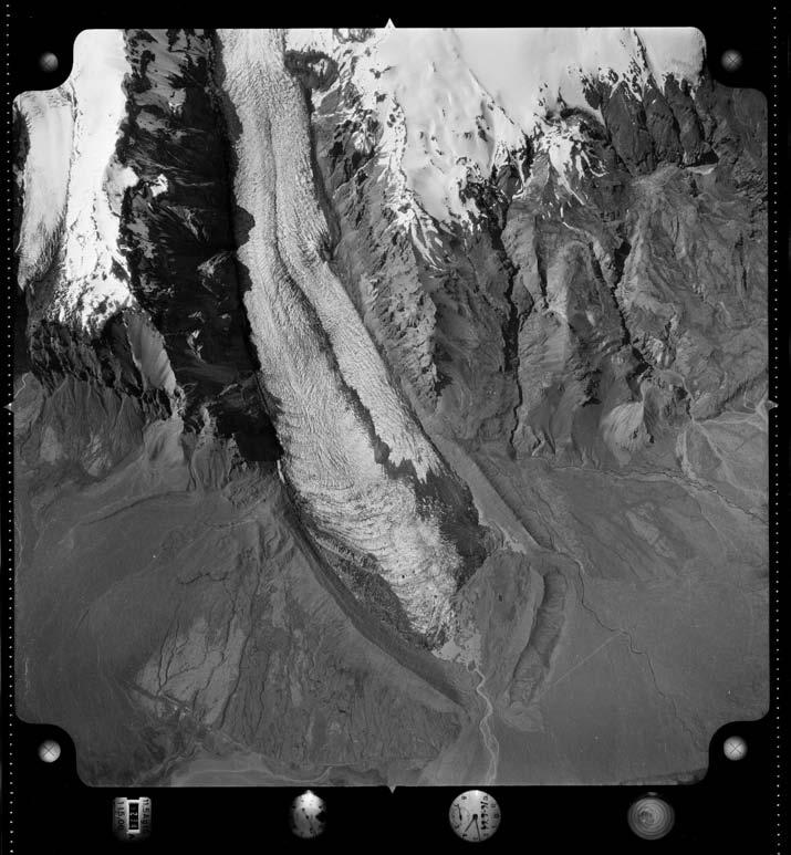
3 1. Introduction The concepts of landsystems and process-form models in glacial geomorphology are increasingly being developed and improved through the use of contemporary analogues, wherein ongoing process-form relationships can be unequivocally demonstrated (e.g. Boulton and Eyles, 1979; Krüger, 1987; Owen and Derbyshire, 1989; Evans and Rea, 1999; 2003; Kirkbride, 2000; Evans et al., 1999b; 2006b; 2007; 2009a;b; Evans, 2003a; 2009a;b; Kjær and Krüger, 2001; Lyså and Lønne, 2001; Andrzejewski, 2002; Evans and Twigg, 2002; 2004; Schomacker and Kjær, 2007; Benediktsson et al., 2008). The recent accelerated recession of glacier snouts around the world, punctuated by occasional readvances and accumulation season oscillations, has facilitated more systematic and quantitative analyses of glacial geomorphic processes on the forelands of glaciers with varying dynamics and morphologies. The time-series of maps of Kvíárjökull (Figure 1) presented in this paper provide a multi-temporal record of glacier retreat by utilizing a long aerial photograph archive commencing in 1945 (Figure 2). They also constitute the most recent additions to the map archive of Icelandic glacier snouts and forelands, produced as part of a long term surveying and landsystems research programme (Evans and Twigg, 2000; 2002; 2004; Evans et al., 2006a;b; 2007; Evans, 2009a;b). These maps provide a sequential record of glacier retreat following the Little Ice Age maximum and illustrate the development of characteristic landform assemblages of a debris-charged glacier (Spedding and Evans, 2002; Evans, 2005). Consequently, they will serve as a spatially and temporally quantified landsystem model for use in palaeoglaciogical reconstructions in moderate relief terrain. Drangajökull Arctic Circle Langjökull ICELAND Snaefell Ice Caps REYKJAVIK Hofsjökull Myrdalsjökull Vatnajökull Kvíárjökull 0 Km 100 Figure 1. Location map of Kvíárjokull, Iceland. Kvíárjökull, located at N and W, is a temperate outlet glacier of the Öræfajökull icecap and occupies a deep incision or short trough in the southern margin of the Öræfi volcano in southeast Iceland (Figure 1). Below the equilibrium line the glacier is fed by an extensive icefall and terminates as a low-angled piedmont tongue. A high debris turnover by the glacier (Eyles, 1979; 1983) is indicated by the size of its latero- 41

4 (a) (b) 42

5 (c) (d) 43
.")
6 (e) Figure 2. Thumbnail images of aerial photographs from each of the 5 years used in the construction of the maps of Kvíárjökull. a) 1945; b) 1964; c) 1980; d) 1998 and e) frontal moraine ridges, which reach a height of 150 m and are the largest in Iceland, being referred to as an enormous amphitheatre by Thórarinsson (1956). Because of their prominence in the landscape they have been named Kvíármýrarkambur (south lateral) and Kumbsmýrarkambur (north lateral). These moraines are thought to have formed over the first period of icecap expansion that occurred within the Neoglacial at around 3200 B.P. (Thórarinsson, 1956; Gudmundsson, 1997; Spedding and Evans, 2002). Along the length of the ice fall, over which the glacier descends from its ice cap down to the coastal plain, steep volcanic rock walls up to 600 m high feed extraglacial debris to the margins of the glacier, and at its terminus the glacier overlies a 50 m deep overdeepening (Spedding and Evans, 2002). The unique topography and high turnover associated with the wet maritime climate combine to produce complex debris transport pathways that differentiate it from a glaciated valley landsystem (Spedding and Evans, 2002; Swift et al., 2006). Although it is a piedmont glacier, Kvíárjökull differs from other Icelandic south coast active, temperate glacier snouts in that its lateral spread has been restricted during the Neoglacial by the latero-frontal moraine and it contains relatively large volumes of debris-rich basal ice and englacial debris septa, which have led to the historical development of complexes of ice-cored ( controlled ; Evans, 2009a) and hummocky moraine and pitted outwash fans and kame terraces inside the latero-frontal moraine amphitheatre" or loop. The high debris content is a product of: a) the large volume of debris transported through the glacier system by rockfall and along passive 44
7 debris pathways (Eyles, 1979); b) the entrainment of material through thrusting and longitudinal flow compression (ogive formation) at the base of the icefall; c) regelation and folding/thrusting of water-worked debris from englacial channel fills; and d) localized supercooling (Spedding and Evans, 2002; Swift et al., 2006). The potential operation of supercooling at Kvíárjökull is a matter of some debate (cf. Roberts et al., 2002; Spedding and Evans, 2002; Swift et al., 2006), one that is crucial to the identification of supercooled snouts in the palaeoglaciological record. For example, Larson et al. (2006) have identified a Pleistocene landsystem imprint at Lake Michigan that they regard as indicative of former supercooling. It features stratified diamictons, interpreted as melt-out tills derived from thick sequences of debris-laden, stratified basal ice, in a landform assemblage of hummocky terrain and kettle holes lying on the distal or adverse slope of an overdeepening. The equifinality problems associated with this interpretation have been discussed at length by Evans (2009a), but progress in palaeoglaciological reconstruction relies on an increasing number of modern landsystem exemplars; improving knowledge of the debris entrainment processes at Kvíárjökull coupled with maps that document the evolution of its proglacial landform-sediment assemblage are therefore invaluable to glacial geomorphology. 2. Methods 2.1 Data acquisition The aerial photograph dataset used for mapping was obtained from Landmælingar Íslands and Loftmyndir ehf (Figure 2; Table 1). All photographs were scanned to a high resolution (15 µm) on a photogrammetric scanner. Twelve ground control points were collected around the glacier foreland in summer 2006 using differential GPS. These were generally large stable boulders deposited on the outer slopes of the latero-frontal moraine rampart and pre-date 1945, thereby avoiding the need for secondary ground control (e.g. Fox and Cziferszky, 2008). Photograph a Nominal Scale Camera calibration Ground resolution (cm) BW 1:50000 Only focal length + flying height BW 1:50000 Complete BW 1:50000 No fiducials BW 1:30000 Complete RGB 1:25000 Complete 51 Table 1. Aerial photograph specifications. a BW and RGB indicate panchromatic and colour photography respectively. 45
8 Year DEM Resolution (m) Number of GCPs RMSE (m) DEM coverage Complete Complete Top left corner missing Complete Complete Table 2. DEM specifications. 2.2 Data processing Digital photogrammetric processing of the aerial photographs was conducted in Leica Photogrammetry Suite 9.1 (LPS). LPS uses the bundle block adjustment, using least squares estimation, to establish the relationship between the positions of a set of photographs and a ground coordinate system, based on the interior and exterior parameters input into the software and the location of ground control points. Each set of photographs was processed as for a metric camera with the exception of 1945 and 1980 for which incomplete camera calibration information required processing for a non-metric camera. The projection used was UTM, with the spheroid WGS 84 for zone 28N. The selection of strategy parameters was based on a visual inspection of digital elevation models (DEMs) output using different strategy parameters. Five DEMs were generated from the historical aerial photography with ground resolutions ranging from 2.5 to 4.5 m, depending on the resolution of the aerial photographs (Table 2), and based on a 5x5 correlation window in the stereo matching process. For example, the size of one pixel in real space in the 2003 photographs is 51 cm. The maximum DEM resolution that can be achieved using a 5x5 pixel window is 5 times this value at Whilst a finer resolution DEM could have been generated using a smaller window size (e.g. 3x3), this would have resulted in greater matching errors, because there is an increased likelihood that 9 pixels will be mismatched on two images using a 3x3 window compared to 25 pixels being wrongly matched using a 5x5 window. Therefore DEM resolution is sacrificed for the sake of better DEM quality. Orthophotos were generated by resampling the aerial photographs using the DEMs at the resolution of the original photographs. 2.3 Geomorphological mapping Overlays of the surficial geology and geomorphological features were digitally drawn in ArcMap using the generated orthophotos. This was accomplished by a combination of stereoscopic viewing and interpretation of aerial photographs, scrutinizing different visualizations of the DEMs, and field mapping. The UTM grid (WGS84, 28N) is com- 46
9 patible with the system currently used on Icelandic maps produced by Landmælingar Íslands. Contour plots at 10 m intervals that accompanied the extraction of the DEMs were smoothed in ArcMap using a smoothing algorithm. The cartographic design was based on previous maps produced by Evans and Twigg (2000) and Evans et al. (2006a;b; 2007; 2009a;b). DEM extraction resulted in an inevitable reduction in resolution from that of the aerial photographs. Therefore only larger features such as moraine complexes, large moraine ridges, eskers and outwash fans could be identified in the DEMs. The identification of these within the DEMs was aided by well known visualization techniques: relief shading, slope gradient and aspect (Smith and Clark, 2005) (Figure 3). Smaller features were identified in the high resolution orthophotos, aided by stereoscopic viewing of the aerial photographs. The evolution of many features was apparent in the time series of aerial photographs enabling the origin of many features to be confidently identified. Furthermore morphometric analysis based on a temporal sequence enabled the identification of ice-cored features within the foreland and the ice marginal oscillations responsible for linearity in hummocky moraine belts. Smaller linear features such as crevasse fills, push moraine ridges, kame terraces, ice cliffs and eskers all have a similar morphology but have been differentiated to a high level of confidence due to: a) the high ground resolution of the aerial photographs of between 0.5 and 0.9 m; and b) the verification of features in the field over the period Glacial geomorphology and surficial geology In addition to bedrock surfaces (blue/grey) that dominate in the area of the cliffs that bound the glacier on the western edge of the maps, twelve surficial geology units are recognized. These can be grouped according to their location and age: 1) supraglacial debris occurs only on the glacier surface; 2) the category of till" includes deposits laid down by glacier ice but these have mostly been emplaced by a variety of supraglacial processes and therefore most areas of this map unit are more appropriately described as supraglacial morainic till" (Boulton and Eyles, 1979). Small areas of this till cover, too small to map at this scale, will have been post-depositionally reworked by paraglacial processes. Till is sub-divided according to its age relative to the recent Little Ice Age" (LIA); recession from the LIA limit started at around 1905AD but the LIA till is draped over moraines of older, Neoglacial age (Evans et al., 1999a). Therefore we recognize four sub-divisions of till at Kvíárjökull: a) ice-cored moraine; b) post-lia till, lying inside the latero-frontal moraine loop; c) LIA till, lying over the older deposits that comprise the latero-frontal moraine loop; and d) pre-lia till, lying outside the latero-frontal moraine loop and including the latero-frontal moraine remnants that extend beyond the LIA limit; 3) glacifluvial deposits are contained within proglacial sandar and ice-marginal 47
 glacilacustrine deposits relate to short-lived proglacial lakes on the proximal foreland; 5) non glacial materials include paraglacial deposits or reworked glacigenic sediment,")
10 Figure 3. Visualisations of the 1998 DEM. a) overlaid with orthophoto; b) relief shaded; c) aspect; and d) slope gradient. kame terraces; 4) glacilacustrine deposits relate to short-lived proglacial lakes on the proximal foreland; 5) non glacial materials include paraglacial deposits or reworked glacigenic sediment, scree accumulating below bedrock cliffs and blockfield and residuum. Additionally, fresh debris flow deposits are recognized within the paraglacial category because of their extensive development on the latero-frontal moraine; 6) ancient jokulhlaup fans occur outside the latero-frontal moraine loop. Geomorphological features relevant to each of the surficial geology units are mapped using symbols and these are described below in association with the surficial units in which they occur. 48
11 3.1 Supraglacial debris cover A characteristic feature of Kvíárjökull is its supraglacial debris cover, a feature that prompted Eyles (1979; 1983) to propose the glacier as an exemplar of the glaciated valley landsystem (cf. Spedding and Evans, 2002). It forms a thin veneer on the glacier snout and is concentrated in a single medial moraine, separating north and south ice flow units, and at the edge of the glacier within margin-parallel/arcuate, up-ice descending, debris-rich foliae that are melting out to form controlled moraine (Figure 4a; Evans, 2009a). The medial moraine characteristically widens as it approaches the glacier margin due to the increasing rate of ice ablation and concomitant lateral spreading of the debris as it melts out. Nearer to the margin, the supraglacial debris cover represents the initial stage in the development of ice-cored moraine, referred to by Clayton (1964) as the young phase", and at Kvíárjökull is related to active ice and transport of debris to the glacier surface along rising debris-rich folia (Spedding and Evans, 2002; Swift et al., 2006). The concentration of debris-rich ice around the snout has been related to the potential occurrence of supercooling in the overdeepening (Roberts et al., 2002), but Spedding and Evans (2002) and Swift et al. (2006) have used subglacial and fluvial clast form characteristics to demonstrate that other processes, such as englacial drainage and ogive formation at the base of the icefall, are likely more significant as debris transfer processes. The medial moraine on Kvíárjökull is fed by rockfall from a bedrock outcrop in the icefall and hence its debris can be differentiated from that melting out from the rising folia on the northern part of the glacier surface due to its red colouration and angular clast forms. A rockfall origin is also likely for the rising debris-rich folia on the south lateral margin of the glacier, because of the mono-lithological content and clast angularity; in contrast to the medial moraine, this debris has been entirely incorporated into englacial positions as ogives after its initial delivery to the glacier surface, which most likely took place on the heavily crevassed part of the snout and/or above the equilibrium line. Nearer the frontal margin of the glacier snout, the supraglacial debris cover becomes increasingly dissected by ice-walled channels, which are occasionally continuous with englacial eskers. This suggests that the roofs of englacial and/or subglacial tunnels are collapsing or tunnel fills are being exposed as the snout thins. Together with the widening of moulins on the southern flow unit of the glacier, this is indicative of the more advanced stage of glacier downwasting, leading ultimately to glacier karst" (Figure 4b; Clayton, 1964). However, this does not indicate glacier stagnation, as the moulins have been a conspicuous feature on the south flow unit of the snout since 1945 and therefore likely relate to a stable glacial meltwater drainage system fed by geothermal activity in the Öræfi caldera. Nonetheless, a proglacial lake has fluctuated in size between 1980 and 2003 and more recently the ponded water has started to flood the thinning snout and occupy the enlarged moulins to produce a supraglacial extension of the lake (Fi- 49
 viewed across the southern flow unit, showing arcuate bands of debris-rich foliae which feather out towards the centre of the snout.")

12 (a) (b) Figure 4. The supraglacial debris cover of Kvíárjökull in 2007: a) viewed across the southern flow unit, showing arcuate bands of debris-rich foliae which feather out towards the centre of the snout. Each band contains a distinct clast lithology representative of a rockfall origin in the area of the icefall. Increasing ablation towards the snout has resulted in the development of controlled moraine ridges in the middle ground. These are being consumed by the expansion of glacier karst and supraglacial lake water visible on the bottom right. Also visible in the distance is the red coloured debris of the medial moraine, which has protected the underlying ice from ablation to produce a significantly higher area on the snout; b) localized ponding, indicative of the more advanced stages of glacier downwasting and the development of glacier karst. Interbedded stratified sediments and mass flow diamictons accumulate in such hollows throughout the period of snout melting. gure 5). The lake will most likely expand in area and depth as the overdeepening is uncovered by glacier thinning and recession (cf. Kirkbride, 2000). 50
 and controlled/hummocky")
13 Figure 5. View northwards across the ice-marginal zone of Kvíárjökull in 2007, showing the recent development of a proglacial/supraglacial lake behind the outwash head (foreground) and controlled/hummocky moraine (middle distance). The role of the medial moraine in protecting the snout from ablation is also illustrated by the red coloured debris draping the ice cliff in the middle distance. Note also the pitted surface of the sandur fan, the channelled outwash and linear hummocky moraine in the right middle distance and beyond the latero-frontal moraine loop with its extensive debris flow scars and gullying (paraglacial deposits). 3.2 Ice-cored moraine (till) Another characteristic feature of Kvíárjökull is its latero-frontal band of ridges or mounds with a relief greater than the adjacent supraglacial debris cover and underlain by buried glacier ice or containing remnant ice cores (Figure 6; Evans, 2009a). This is a product of differential melting and localized thickening of supraglacial debris cover by topographic reversal (cf. Kjær and Krüger, 2001) as well as the advanced development of glacier karst features such as ice walled lakes and collapsed englacial tunnels (Clayton, 1964). This landform/surficial unit is not necessarily completely detached from the glacier-snout, as is suggested to be necessary bylukas et al. (2007) for it to be classified as ice-cored moraine"; it is impossible to define the boundary of active snout ice, which is likely to continue locally into the ice-cored ridges and even below the pitted outwash on the foreland (Evans, 2009a). Several features are indicative of the ice disintegration (backwasting and downwasting) and associated sediment reworking that occurs in ice-cored moraine at the mature stage of development (Kjær and Krüger, 2001). Boulder ridges are linear clusters of boulders that typically occur along the base of ice-cored slopes due to gravitational sorting of debris triggered by ice melt out (Kjær and Krüger, 2001). Sink holes with concentric tension cracks on their inner slopes are small depressions in the debris cover which indicate the collapse of underlying ice (Figure 6b). Meltwater filled depressions in the ice-cored moraine are indicative of more substantial ice cores and are mapped using 51
 exposed by slope collapse, fluvial erosion or mass-movements induced by heavy rainfall (Krüger and Kjær,")
 as well as their")
14 the symbol for lakes (blue polygon with dark blue outline). They are often bounded by ice cliffs (black line with hollow triangle) exposed by slope collapse, fluvial erosion or mass-movements induced by heavy rainfall (Krüger and Kjær, 2000). Other features include eskers and controlled ridges, which are identifiable by their clast forms (higher proportions of water-worked and subglacial material) as well as their linearity amongst high relief hummocks and sink holes. Further linearity has been imparted on ice-cored moraine where it has been pushed by recent ice-marginal oscillations (Evans, 2009a, Figure 6a, c). Former englacial tunnels are also visible as elongate, sinuous sink holes. (a) (b) 52
 at the northern margin of Kvíárjökull in 2009: a) overview of ice-cored moraine showing linearity in arcuate hummocky ridges, which record ice-marginal pushing of the buried")
15 (c) Figure 6. Ice-cored moraine (till) at the northern margin of Kvíárjökull in 2009: a) overview of ice-cored moraine showing linearity in arcuate hummocky ridges, which record ice-marginal pushing of the buried snout ice; b) localized ponding and exposure of buried glacier ice at the locality identified by the E" in Figure 6a. Note the tension cracks surrounding sink holes in the foreground, indicative of melt-out of deeply buried glacier ice; c) exposure through the ice-cored moraine belt in 2000, showing the compressional folding in the crudely stratified sediments at the distal margin of the feature where ice-cored ridges have been bulldozed into fully de-iced hummocks. Since 1945 the latero-frontal arc of ice-cored moraine has migrated up valley with the receding snout, indicating that the production of debris-rich basal ice is an ongoing process. Moreover, evidence of glacier pushing of the ice-cored moraine (Spedding and Evans, 2002; Evans, 2009a) reveals that Kvíárjökull is undergoing active recession, similar to other Icelandic temperate glacier lobes where the bulldozing of marginal sediments, often annually, is common (Price, 1970; Boulton, 1986; Krüger, 1993; 1995; 1996; Evans and Twigg, 2002; Evans, 2003b; 2005; Evans and Hiemstra, 2005). The proglacial pushing of partially de-iced controlled moraine at Kvíárjökull (Figure 6a) demonstrates that the glacier is coupled to the regional climate. This glacier-climate linkage is possible because the debris cover at the snout is confined to the outer 100 m and therefore does not dampen the mass balance signal from the accumulation zone. Therefore the ice-cored moraine and hummocky moraine (see below) of the foreland is a product of incremental stagnation" (Eyles, 1979; 1983). More specifically, the ice-cored moraine on the 1945 and 1964 maps is gradually replaced by post LIA hummocky moraine (see below) in the 1998 and 2003 maps, demonstrating a clear process-form relationship. 3.3 Post-Little Ice Age till Recession of the glacier snout from the base of the latero-frontal moraine rampart has produced a gently undulating terrain comprising moraine complexes of margin-parallel 53
16 linear mounds or hummock chains, often containing high concentrations of water-worked clasts (Figure 7). These landforms have been formed by a combination of the melt out of controlled moraine and the ice-marginal bulldozing of ice-cored moraine and proglacial outwash sediments during active retreat between 1964 and Prior to this time the moraine surfaces were characterized by features indicative of ice core melt-out (see above section and 1945 map). In some areas the post-lia moraines still contain shallow sink holes and turbid lakes that record the final stage of ice-melt out (Kjær and Krüger, 2001). In the outer foreland, moraine complexes are extensively dissected by channels infilled with terraced glacifluvial deposits or ribbon sandur (Figure 7a) and are locally overrun by paraglacial sediments in the form of debris flow fans at the base of the proximal slopes of the latero-frontal moraines. Although paraglacial reworking has been intensive on the proximal slopes of the latero-frontal moraine loop, a number of inset lateral and frontal moraines have survived on the more shallow slopes surrounding the eastern end of the foreland (Figure 7b). Intensive clast form analysis undertaken by Spedding and Evans (2002) has demonstrated that the latero-frontal moraines contain significant quantities of subglacially and fluvially derived material, which increase down moraine in a fashion similar to lateral moraines in mountain terrains where materials indicative of extraglacial transport pathways are gradually diluted by those modified in the subglacial zone and those reworked from proglacial outwash (Matthews and Petch, 1982; Evans, 1999). Additionally, Spedding and Evans (2002) cite the ubiquitous evidence for englacial drainage pathways as a further transport pathway capable of clast modification. Therefore, the striking size and volume of the moraines is not indicative of abnormally high extraglacial debris provision from the steep rockwalls above the icefall (cf. Eyles, 1979; 1983). 3.4 Little Ice Age and pre-little Ice Age till A Little Ice Age status for the bouldery materials covering the latero-frontal moraine loop is based on observations by Thórarinsson (1956) that the glacier last filled its foreland and overtopped these ridges during the LIA. Recession from the summit of the moraine loop began around 1905 AD (Evans et al., 1999a). Therefore, during the LIA the glacier deposited a mantle of till on the latero-frontal moraine loop and early recession from its summit is recorded by inset moraine ridges (Figure 8). It is recognized, however, that the latero-frontal moraines are composite features built up over the Neoglacial (Thórarinsson, 1956) and that much of the underlying material and perhaps surficial deposits on the outer moraine slopes dates to pre-lia times. Moroever, smaller latero-frontal moraine remnants extend from the distal slopes of Kvíármýrarkambur and Kumbsmýrarkambur and are blanketed by Öræfi 1362 tephra, clearly dating them to pre-lia times (Gudmundsson, 1997). Sections through the proximal slopes of the latero-frontal moraine loop reveal crudely to well stratified boulder to gravelly diamic- 54
 view over the linear hummocky moraine ridges on the south side of the foreland, showing spreads of ribbon sandar between moraines; b) view over")
 and the inset sequences of lateral moraines on the paraglacially gullied inner face of Kvíármýrarkambur.")
17 (a) (b) Figure 7. Post Little Ice Age till and landforms in 1992: a) view over the linear hummocky moraine ridges on the south side of the foreland, showing spreads of ribbon sandar between moraines; b) view over linear hummocky moraine on north side of foreland, showing more complex forms likely produced by ice-marginal pushing of ice-cored moraine (cf. Figure 6a for more recent example) and the inset sequences of lateral moraines on the paraglacially gullied inner face of Kvíármýrarkambur. tons, indicative of moraine construction by the mass flowage of glacigenic materials fed by the glacier margin. As noted in the previous section, the down-moraine increase in subglacially and fluvially modified clasts indicates that Kvíárjökull deposited the debris on the latero-frontal moraine loop after transporting it from subglacial and englacial positions, a process likely responsible for the excavation of the overdeepening. Alternatively or additionally, the glacier reworked a large outwash fan that existed on the coastal lowland prior to Neoglacial expansion (cf. Boulton, 1986; Evans and Twigg, 2002; Evans, 2003b). 55
 view along the summit of Kvíármýrarkambur in 2007, showing thin spread of LIA maximum boulders locally thickening to produce a small push moraine.")

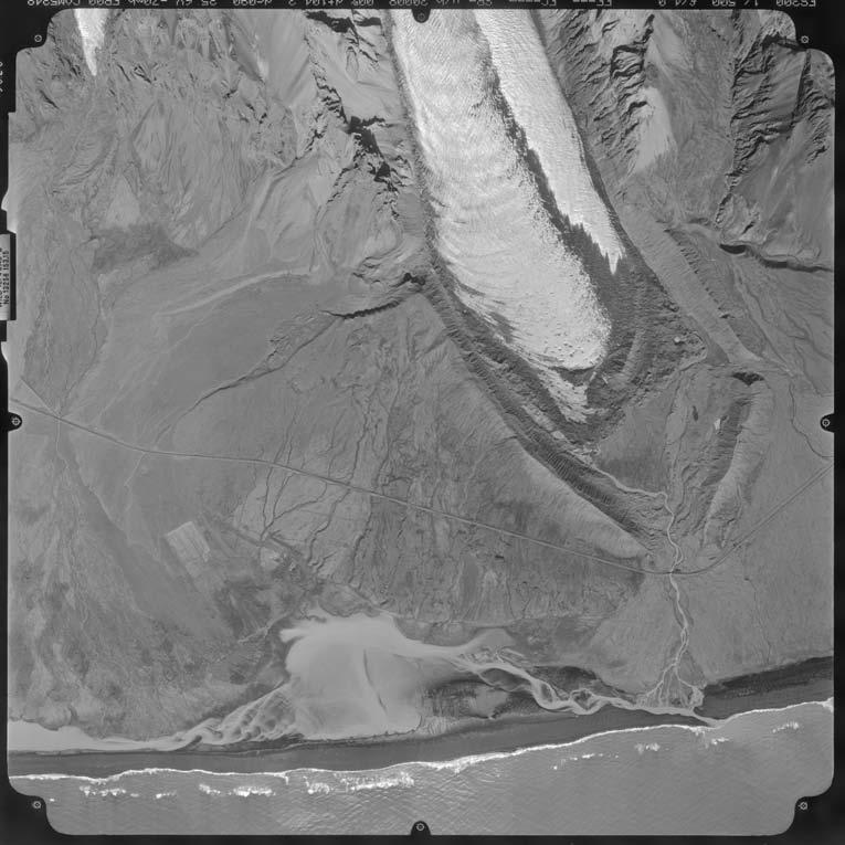
18 (a) (b) Figure 8. Little Ice Age and older sediments and landforms: a) view along the summit of Kvíármýrarkambur in 2007, showing thin spread of LIA maximum boulders locally thickening to produce a small push moraine. This has been draped over the bulk of the latero-frontal moraine rampart deposited during earlier stages of ice advance in the Neoglacial; b) view along the summit of Kumbsmýrarkambur in 1992, showing the inset sequence of LIA moraine draping the older lateral moraine. Note the location of the ice margin in this view, when the uppermost of a flight of inset kame terraces depicted in Figure 10 were being constructed. 3.5 Glacifluvial deposits Glacifluvial deposits are contained in either proglacial outwash fans (Figure 9) or kame terraces (Figure 10). Older outwash fans dating to pre-lia or LIA time are mapped as jokulhlaup outwash and lie outside the latero-frontal moraine loop, with their apexes located at breaches in the loop, immediately below the bedrock cliffs on the north and 56

19 south sides of the glacier. Meltwater discharge from these breaches had ceased by 1945 but it was responsible for the incision of the outwash fans during early post-lia glacier recession, as documented by moraine/valley train associations in the breaches. In the narrow lowland area between the easternmost part of the latero-frontal moraine loop and the coast, a proglacial sandur fan has been constantly occupied and reworked by meltwater since at least Since Kvíárjökull has receded inside the moraine loop, glacifluvial deposits have been concentrated in kame terraces and a small proglacial outwash fan. The latter occupies the expanding foreland and narrows due to the restricted nature of the contemporary breach in the moraine loop to the east. This fan appears partially flooded at its distal end in 1964 and 1980 when buried glacier ice started to melt out in significant volume. Figure 9. A 2007 view over the proglacial outwash fan that has been deposited over the glacier snout. Note the outwash head or ice-contact slope at the margin of the overdeepening now filled with lake water. Surface pitting along the fan surface attests to the melt-out of snout ice. The sequence of maps charts the evolution of the proglacial and lateral glacifluvial assemblages and depicts the influence of ice melt and changing sediment delivery on their form. In 1945 meltwater drained from the centre of the snout terminus, creating a small outwash fan in a corridor through the ice-cored moraine on the foreland. By 1965 the apex of the fan had shifted northwards and by 1980 further drainage was coming from the northern margin of the glacier via the expanding lakes produced by melt-out of buried ice in the ice-cored moraine belt. Consequently, the proglacial fan surface descended in altitude from north to south and ran parallel to the frontal margin of the glacier. Each of these phases is associated with the development of kettle holes and the production of pitted sandur due to the progradation of sands and gravels over the glacier snout and over the remains of reworked ice-cored moraine tracts. By 1998 the fan apex had again shifted southwards to the centre of the snout and kettle holes were fewer in number all over the fan surface, probably due to increased sediment flux and glacifluvial deposition. A further shift in the meltwater efflux point by 2003 shows that drainage was predominantly from two expanding proglacial/supraglacial lakes at the northern and southern glacier margins, likely precursors to a future large proglacial lake situated 57


20 in the overdeepening. The outwash fan as a consequence is now elevated above the lakes and is therefore relict. Its abandonment has once again led to the development of a pitted surface due to the melt-out of buried glacier ice. Eskers and fragmented waterfilled channels emerging on the adjacent glacier surface in 2003 (Figure 11), all converge on the outwash fan apex, revealing the englacial drainage network that formerly fed the fan. Unlike ice-contact outwash fans reported at other Iceland glacier snouts, which typically display pitted surfaces at their apexes, the Kvíárjökull proglacial fan has always, with the exception of 1998, contained pits along its entire length, attesting to the burial of an extensive area of glacier snout due to progradation of glacifluvial sediment into the overdeepening (Figure 9). This is best illustrated in the 2003 map where the distal, (a) (b) 58
 view from ice-cored hummocky moraine in 2009, showing accordant surfaces of terrace remnants in the distance which give the impression of")
 exposure of buried glacier ice in the kame terraces being deposited in 1992 (appearing at left in Figure 9b) at a time when marginal meltwater began to")
21 (c) Figure 10. Kame terraces along the northern margin of Kvíárjökull: a) view from ice-cored hummocky moraine in 2009, showing accordant surfaces of terrace remnants in the distance which give the impression of continuous benches; b) view across older terraces (left) towards freshly deposited features at the ice margin, showing the importance of ongoing incision and tunnelling of buried ice and concomitant collapse of overlying gravel bench; c) exposure of buried glacier ice in the kame terraces being deposited in 1992 (appearing at left in Figure 9b) at a time when marginal meltwater began to disappear sub-marginally through englacial tunnels. The collapse of ice tunnel roofs leads to the deposition of ice-walled channel fills or supraglacial trough fills, which are locally attached to kame terraces. This process also leads to the juxtaposition of eskers and kames. Figure 11. Supraglacial esker emerging from the downwasting glacier snout in The tops of these features were beginning to emerge on the glacier surface in eastern as well as the western, ice-contact margins of the sandur fan have collapsed to form linear extensions of the southern proglacial/supraglacial lake (Figure 4b). Since 1945 glacifluvial sediment has accumulated between the proximal slope of the latero-frontal moraine loop and the northern margin of the glacier in a series of kame terraces that have partially buried the thinning snout (Figure 10). The large volume of 59
22 glacier ice beneath these features is evidenced by extensive faulting and collapse. Older features have been almost totally fragmented by ice melt-out and consequently their former horizontal surface is only apparent in the accordance of the remnant surfaces (Figure 10a). The kame terraces are locally draped by mounds and ridges of red-coloured, angular medial moraine debris dumped directly from the glacier snout on to the accumulating glacifluvial landforms. Smaller areas of glacifluvial deposits occur in ribbon sandar between moraine ridges in the post-lia till units (Figure 7a). This network of ribbon sandur and channels was well developed by 1964 and largely relict by 1980, attesting to the melt-out, fluvial reworking and gradual stabilization of ice-cored moraine between 1945 and Glacifluvial deposits are also contained within eskers, which at Kvíárjökull occur as discontinuous sinuous gravelly ridges that can be traced from englacial and supraglacial positions to the ice-cored moraine around the glacier margin (Figure 11). The emergence, and in most cases in the ice-cored moraine the disappearance, of these eskers through the sequence of maps indicates that they relate to englacial drainage networks (cf. Spedding and Evans, 2002) whose traces become fragmented by the progression of ice core melt-out. If englacial tunnel drainage is widespread in the snout, as envisaged by Spedding and Evans (2002) based on observations on emerging landforms and clast form data, the relict outwash fan that overlies an extensive part of snout ice in the overdeepening should continue to collapse and gradually expose eskers in a similar fashion to the sandar and esker systems at BreiDamerkurjökull (Price, 1969; Evans and Twigg, 2002). 3.6 Glacilacustrine deposits Substantial proglacial lakes have developed intermittently on the foreland of Kvíárjökull, specifically in 1964, 1980 and 2003, where the downwasting snout has locally been flooded before proglacial outwash aggrades and fills up the accommodation space provided by the overdeepening (Figure 2). On the deglaciated forelands of southern Iceland such lakes typically occupy the ice-proximal depressions formed by the abandonment of ice-contact outwash fans or outwash heads (e.g. Howarth and Price, 1969; Evans and Twigg, 2002). At Kvíárjökull additional lakes are produced within tracts of downwasting ice-cored moraine, where the lake water is at least partially supraglacial in nature (Figure 5). This is best illustrated at the northern margin of the snout where until at least 1964 a narrow lake occupied the depression between ice-cored moraine and lateral moraine. This had disappeared by 1998, a time when no lakes appeared anywhere on the foreland, but a substantial lake was developing in the ice-cored moraine at the northern snout margin by 2003 (Figure 6a). The ephemeral nature of the proglacial/supraglacial 60

23 lakes at Kvíárjökull, together with their development in a confined foreland that is largely ice-cored and repeatedly reworked by melt-out and meltwater streams, results in the very restricted accumulation of glacilacustrine deposits. The reworking of these deposits is well illustrated in the maps by their changing areal extent over time. Nonetheless, the maps allow us to predict that glacilacustrine deposits will interdigitate with glacifluvial and mass movement deposits in a complex sequence of folded and faulted sediments in a hummocky terrain once the foreland at Kvíárjökull has undergone complete melt-out. 3.7 Non-glacial materials (paraglacial deposits, scree and residuum) Scree and residuum occur in small areas at the bases of the bedrock buttresses that form the northeastern and southeastern boundaries of Kvíárjökull. Although residuum is predominantly the product of weathered bedrock, some highly weathered and winddeflated glacially transported material may be present. Paraglacial deposits comprising colluvially re-worked glacial sediments occur extensively on both the proximal and distal slopes of the latero-frontal moraine loop, with the degree and intensity of reworking increasing through time, especially as distal slopes become more extensive due to glacier downwasting. Paraglacial deposits are dominated by debris flow features such as channels and levees and lobate fans or cones (Figures 7b, 12). Due to the increasing importance of paraglacial slope processes around the foreland, fresh debris flow deposits are identified as a separate surficial unit in the 2003 map. Figure 12. Debris flow lobe and source gully on the inner slopes of Kvíármýrarkambur. 61
24 4. Synopsis The frequency of aerial photography of many Icelandic glacier snouts and forelands has facilitated time series mapping of landform-sediment assemblages indicative of specific glacial landsystems (Price, 1969; Evans and Twigg, 2002; Evans et al., 2007; 2009a;b; Benediktsson et al., 2008). These modern process-form analogues are also long term cryospheric monitoring programmes that serve as powerful diagnostic criteria for palaeoglaciological reconstructions in an arena of geomorphology that is traditionally heavily reliant on ergodic principles. Our maps of Kvíárjökull record the evolving patterns of landform and sediment associations relating to the recession of a debris-charged glacier snout lying above an overdeepening. Although it is now recognized that Kvíárjökull is not an appropriate exemplar of the glaciated valley landsystem due to its piedmont tongue morphology and the dominance of actively over passively transported debris (cf. Eyles, 1983; Spedding and Evans, 2002; Evans, 2005; Swift et al., 2006), it nonetheless has much in common with the moderate debris/high ice flux end of the glaciated valley landsystem continuum identified by Benn et al. (2003), in which debris cover does not buffer glacier responses to short timescale (annual-decadal) climatic signals and strong coupling between glacier and proglacial meltstreams leads to the development of an outwash head. The maps of Kvíárjökull presented in this paper illustrate how complex transport pathways in a temperate, debris-charged piedmont glacier are manifest in the landform record over a sustained period of glacial retreat and moraine formation. They also document the evolution of a glacier foreland characterized by an overdeepening, which has become increasingly effective as a depositional sink for ice-marginal glacifluvial sediments. Additionally, the enclosure of the glacier foreland by the latero-frontal moraine loop has resulted in the aggradation of glacifluvial outwash on the immediate foreland and the concomitant burying of the downwasting glacier snout. Continued melt-out of the buried snout ice is manifest in extensive pitting of the proglacial sandur surface and the expansion of proglacial lake water which links up with supraglacial lakes developing from expanding glacier karst. The changing ice-marginal dynamics and glacier-topography interactions charted in our maps since 1945, allow the sub-division of the foreland of Kvíárjökull into three zones. Zone A comprises the latero-frontal moraine loop, which accumulated as a sequence of ice-contact, debris flow-dominated fans during a sustained period or periods of positive mass balance (Matthews and Briffa, 2005, Little Ice Age Type Events; LIATE s,). The moraine loop summit was abandoned by the receding glacier margin at the turn of the 20th Century, at which point depositional processes on the ice-proximal slopes were dominated by paraglacial reworking, interrupted by latero-frontal push and dump moraine construction. The latter form an inset sequence of ridges documenting active recession, but moraine continuity has been progressively destroyed by 62
25 paraglacial processes. Kame terraces also developed along the northern and southern margins of the glacier but their positioning on the steep proximal faces of the laterofrontal moraine loop has resulted in significant downslope failure in addition to disaggregation by ice melt-out. Kame terraces are unusual features for a temperate piedmont tongue or lobe and exist at Kvíárjökull only because of the lateral boundary formed by the older moraine loop. This large topographic boundary has forced meltwater streams to follow the ice margin, where they often disappear and continue sub-marginally or englacially before reappearing nearer the snout. Since 1998 the streams have failed to reappear along the margin, probably feeding instead into the proglacial/supraglacial lakes developing in the overdeepening. Zone B is the outer part of the foreland, inside the lower proximal slopes of the eastern end of the latero-frontal moraine loop, where post-lia moraines comprise discontinuous chains of elongate hummocks separated by pitted glacifluvial channels. These landforms constitute evidence of ice-marginal oscillations, and therefore the only indications likely to survive complete deglaciation that Kvíárjökull is an active temperate snout. This moraine is an assemblage of bulldozed, ice-cored ridges that have locally been channelized by marginal, submarginal and supra-marginal meltwater to produce margin-parallel ribbon sandar. Ridge size reflects the former englacial debris concentration as well as the duration of snout stillstand. No subglacial tills have been observed at Kvíárjökull, a reflection of the predominantly supraglacial and proglacial nature of moraine construction in ice-contact glacifluvial material. Zone C covers the ice-marginal zone and proglacial sandur fan and is characterized by widespread collapse due to the melt-out of buried glacier ice. This comprises areas of controlled moraine with their signatures of ice-marginal pushing, kame terrace and icecontact sandur fan. The landform-sediment assemblage that is gradually evolving in this zone will, upon complete deglaciation, be characterized by predominantly chaotic hummocky terrain and heavily kettled surfaces lying on the down-ice or adverse slope of an overdeepening. It is the location of the overdeepening that is conditioning the nature of landform development. Localized linear pockets of sediment with specific grain size and clast form characteristics will mark the former locations of englacial debris concentrations such as eskers, rockfall concentrations and debris-rich foliae. Larger englacial and subglacial meltwater networks may form sinuous ridges (eskers and moulin fills) once they emerge from beneath the melting snout and controlled moraine (cf. Evans and Twigg, 2002). Changes between 1998 and 2003 document the recent expansion of the area of supraglacial ponding and indicate that the glacier snout is beginning to downwaste into the overdeepening. Additionally, the pitting on the downstream end of the proglacial sandur fan is indicative of future collapse of the surface. The pitting of the sandur surface appears to have been interrupted in the 1998 map, when the distal outwash prograded into the proglacial lake visible in The mid 1990 s was a period when Kvíárjökull, like some other south coast snouts, readvanced in response to sustained changes in the North Atlantic Oscillation (Bradwell et al., 2006; Sigurdsson, 2005) 63
26 resulting in the bulldozing and freshening of the linearity of the ice-marginal controlled moraine (Spedding and Evans, 2002; Evans, 2009a). The reduction in areal extent of pitting on the proglacial sandur between the 1980 and 1998 maps was most likely a result of the same readvance, whereby meltwater and glacifluvial sediment was temporarily delivered to the fan apex again after a period of decoupling due to snout thinning below the outwash head. Acknowledgements GLB thanks Durham University for a postgraduate research fellowship. DJAE and DRT thank the participants of the 1992, 1998 and 2002 University of Glasgow/Loughborough University expeditions for field support when glacial geomorphological analysis and ground survey control was established. Work at Kvíárjökull has been funded over the years by the Royal Scottish Geographical Society, the Carnegie Trust, the University of Glasgow and Leica Geosystems. References ANDRZEJEWSKI, L. (2002) The impact of surges on the ice-marginal landsystem of Tungnaárjökull,Iceland, Sedimentary Geology, 149, BENEDIKTSSON, I. O., MÖLLER, P., INGÖLFSSON, O., VAN DER MEER, J. J. M., KJÆR, K. H. and KRÜGER, J. (2008) Instantaneous end moraine and sediment wedge formation during the 1890 glacier surge of Brúarjökull, Iceland, Quaternary Science Reviews, 27, BENN, D. I., KIRKBRIDE, M. P., OWEN, L. A. and BRAZIER, V. (2003) Glaciated valley landsystems, In EVANS, D. J. A., (ed.) Glacial Landsystems, Edward Arnold, London, pp BOULTON, G. S. (1986) Push moraines and glacier contact fans in marine and terrestrial environments, Sedimentology, 33, BOULTON, G. S. and EYLES, N. (1979) Sedimentation by valley glaciers: a model and genetic classification, In SCHLUCHTER, C., (ed.) Moraines and Varves, vol. 33, Balkema, Rotterdam, pp BRADWELL, T., DUGMORE, A. J. and SUGDEN, D. E. (2006) The Little Ice Age glacier maximum in Iceland and the North Atlantic Oscillation: evidence from Lambatungnajökull, southeast Iceland, Boreas, 35, CLAYTON, L. (1964) Karst topography on stagnant glaciers, Journal of Glaciology, 5, EVANS, D. J. A. (1999) Glacial debris transport and moraine deposition: a case study of the Jardalen cirque complex, Sogn-og-Fjordane, western Norway, Zeitschrift fur Geomorphologie, N.F., 2, EVANS, D. J. A. (2003a) Glacial Landsystems, Edward Arnold, London, 734 pp. 64
27 EVANS, D. J. A. (2003b) Ice-marginal terrestrial landsystems: active temperate glacier margins, In EVANS, D. J. A., (ed.) Glacial Landsystems, Arnold, London, pp EVANS, D. J. A. (2005) The Glacier-marginal landsystems of Iceland, In CASELDINE, C., RUSSELL, A., HARDARDOTTIR, J. and KNUDSEN, O., (eds.) Iceland - Modern Processes and Past Environments, Elsevier, Amsterdam, pp EVANS, D. J. A. (2009a) Controlled moraines: origins, characteristics and palaeoglaciological implications, Quaternary Science Reviews, 28, EVANS, D. J. A. (2009b) Glacial geomorphology at Glasgow, Scottish Geographical Journal, 125, EVANS, D. J. A., ARCHER, S. and WILSON, D. J. H. (1999a) A comparison of the lichenometric and Schmidt hammer dating techniques based on data from the proglacial areas of some Icelandic glaciers, Quaternary Science Reviews, 18, EVANS, D. J. A. and HIEMSTRA, J. F. (2005) Till deposition by glacier submarginal, incremental thickening, Earth Surface Processes and Landforms, 30, EVANS, D. J. A., LEMMEN, D. S. and REA, B. R. (1999b) Glacial landsystems of the southwest Laurentide Ice Sheet: modern Icelandic analogue, Journal of Quaternary Science, 17, EVANS, D. J. A. and REA, B. (2003) Surging glacier landsystem, In EVANS, D. J. A., (ed.) Glacial Landsystems, Arnold, London, pp EVANS, D. J. A. and REA, B. R. (1999) Geomorphology and sedimentology of surging glaciers: A landsystems approach, Annals of Glaciology, 28, EVANS, D. J. A., SHAND, M. and PETRIE, G. (2009a) Maps of the snout and proglacial landforms of Fjallsjökull, Iceland (1945, 1965, 1998), Scottish Geographical Journal, 125, EVANS, D. J. A. and TWIGG, D. R. (2000) BreiDamerkurjökull :30,000 Scale Map, University of Glasgow and Loughborough University. EVANS, D. J. A. and TWIGG, D. R. (2002) The active temperate glacial landsystem: a model based on BreiDamerkurjökull and Fjallsjökull, Icelaand, Quaternary Science Reviews, 21, EVANS, D. J. A. and TWIGG, D. R. (2004) þórisjökull: Surficial Geology and Geomorphology of a Plateau Icefield. 1:25,000 Scale Map/Poster, University of Glasgow and Loughborough University. EVANS, D. J. A., TWIGG, D. R. and REA, B. R. (2006a) Surficial geology and geomorphology of the þórisjökull plateau icefield, west-central Iceland, Journal of Maps, v2006, EVANS, D. J. A., TWIGG, D. R. and REA, B. R. (2006b) Surging glacier landsystem of Tungnaárjökull, Iceland. 1:25,000 scale map poster, University of Glasgow. EVANS, D. J. A., TWIGG, D. R., REA, B. R. and SHAND, M. (2007) Surficial geology and geomorphology of the Brúarjökull surging glacier landsystem, Journal of Maps, v2007, EVANS, D. J. A., TWIGG, D. R., REA, B. R. and SHAND, M. (2009b) Surging glacier landsystem of Tungnaárjökull, Iceland, Journal of Maps, v2009, EYLES, N. (1979) Facies of supraglacial sedimentation on Icelandic and Alpine temperate glaciers, Canadian Journal of Earth Sciences, 16,
glacial drift: all deposits associated with glaciation; covers 8% of Earth s surface above sealevel, and 25% of North America
 Glacial depositional features glacial drift: all deposits associated with glaciation; covers 8% of Earth s surface above sealevel, and 25% of North America i) nonstratified drift till: transported & deposited
PHYSICAL GEOGRAPHY GEOGRAPHY EARTH SYSTEMS COASTAL SYSTEMS FLUVIAL SYSTEMS
 PHYSICAL GEOGRAPHY EARTH SYSTEMS FLUVIAL SYSTEMS COASTAL SYSTEMS PHYSICAL GEOGRAPHY CORRIES / CIRQUES A Corrie or Cirque is the armchair shaped hollow that was the birthplace of a glacier. It has steep,
READING QUESTIONS: Glaciers GEOL /WI 60 pts. a. Alpine Ice from larger ice masses flowing through a valley to the ocean
 READING QUESTIONS: Glaciers GEOL 131 18/WI 60 pts NAME DUE: Tuesday, March 13 Glaciers: A Part of Two Basic Cycles (p. 192-195) 1. Match each type of glacier to its description: (2 pts) a. Alpine Ice from
READING QUESTIONS: Chapter 7, Glaciers GEOL 131 Fall pts. a. Alpine Ice from larger ice masses flowing through a valley to the ocean
 READING QUESTIONS: Chapter 7, Glaciers GEOL 131 Fall 2018 63 pts NAME DUE: Tuesday, October 23 Glaciers: A Part of Two Basic Cycles (p. 192-195) 1. Match each type of glacier to its description: (2 pts)
Lidar Imagery Reveals Maine's Land Surface in Unprecedented Detail
 Maine Geologic Facts and Localities December, 2011 Lidar Imagery Reveals Maine's Land Surface in Unprecedented Detail Text by Woodrow Thompson, Department of Agriculture, Conservation & Forestry 1 Introduction
glacier Little Ice Age continental glacier valley glacier ice cap glaciation firn glacial ice plastic flow basal slip Chapter 14
 Little Ice Age glacier valley glacier continental glacier ice cap glaciation firn glacial ice plastic flow basal slip glacial budget zone of accumulation zone of wastage glacial surge abrasion glacial
2. (1pt) From an aircraft, how can you tell the difference between a snowfield and a snow-covered glacier?
 From an aircraft, how can you tell the difference between a snowfield and a snow-covered glacier?") 1 GLACIERS 1. (2pts) Define a glacier: 2. (1pt) From an aircraft, how can you tell the difference between a snowfield and a snow-covered glacier? 3. (2pts) What is the relative size of Antarctica, Greenland,
1 GLACIERS 1. (2pts) Define a glacier: 2. (1pt) From an aircraft, how can you tell the difference between a snowfield and a snow-covered glacier? 3. (2pts) What is the relative size of Antarctica, Greenland,
Chapter 16 Glaciers and Glaciations
 Chapter 16 Glaciers and Glaciations Name: Page 419-454 (2nd Ed.) ; Page 406-439 (1st Ed.) Part A: Anticipation Guide: Please read through these statements before reading and mark them as true or false.
Gifts of the Glaciers
 Gifts of the Glaciers Gifts of the Glaciers Moving ice of glacier was responsible for water, landforms, and soil characteristics and patterns of today Sculpturing of bedrock materials Glacial Landforms
Glaciers and Glaciation Earth - Chapter 18 Stan Hatfield Southwestern Illinois College
 Glaciers and Glaciation Earth - Chapter 18 Stan Hatfield Southwestern Illinois College Glaciers Glaciers are parts of two basic cycles: 1. Hydrologic cycle 2. Rock cycle A glacier is a thick mass of ice
GLACIATION. The Last Ice Age (see Chapter 12) and. Pleistocene Ice Cap. Glacial Dynamics 10/2/2012. Laurentide Ice Sheet over NYS
 and. Pleistocene Ice Cap. Glacial Dynamics 10/2/2012. Laurentide Ice Sheet over NYS") GLACIATION and New York State Prof. Anthony Grande The Last Ice Age (see Chapter 1) The Pleistocene Epoch began 1.6 mya. During this time, climates grew colder. There were numerous ice ages starting 100,000000
GLACIATION and New York State Prof. Anthony Grande The Last Ice Age (see Chapter 1) The Pleistocene Epoch began 1.6 mya. During this time, climates grew colder. There were numerous ice ages starting 100,000000
Glaciers Earth 9th Edition Chapter 18 Mass wasting: summary in haiku form Glaciers Glaciers Glaciers Glaciers Formation of glacial ice
 1 2 3 4 5 6 7 8 9 10 11 12 13 14 15 Earth 9 th Edition Chapter 18 Mass wasting: summary in haiku form Ten thousand years thence big glaciers began to melt - called "global warming." are parts of two basic
Glacial Geomorphology Exercise
 James Madison University Field Course in western Ireland Glacial Geomorphology Exercise 3-day road log (abbreviated) Striations Large kame terrace Cirque with moraines Kame delta Striations Eskers Raised
Ice-marginal geomorphology and Holocene expansion of debris-covered Tasman Glacier, New Zealand
 Debris-Covered Glaciers (Proceedings of a workshop held at Seattle, Washington, USA, September 2000). IAHS Publ. no. 264, 2000. 211 Ice-marginal geomorphology and Holocene expansion of debris-covered Tasman
MIDDLE SCHOOL CURRICULUM TR AILING ICE AGE M YST ERI E S SEARCHING GLACIAL FEATURES
 MIDDLE SCHOOL CURRICULUM TR AILING ICE AGE M YST ERI E S SEARCHING GLACIAL FEATURES CONTENTS I. Enduring Knowledge... 3 II. Teacher Background... 3 III. Before Viewing the Video... 5 IV. Viewing Guide...
Identification and Classification of Kettle Chains Using 2 meter Digital Elevation Model of Long Island! -Sean Tvelia-!
 Identification and Classification of Kettle Chains Using 2 meter Digital Elevation Model of Long Island -Sean Tvelia- Recently released 2.0 meter Digital Elevation Models (DEMs) of the central and eastern
1 Glacial Erosion and
 www.ck12.org Chapter 1. Glacial Erosion and Deposition CHAPTER 1 Glacial Erosion and Deposition Lesson Objectives Discuss the different erosional features formed by alpine glaciers. Describe the processes
LAB P - GLACIAL PROCESSES AND LANDSCAPES
 Introduction LAB P - GLACIAL PROCESSES AND LANDSCAPES Ice has been a significant force in modifying the surface of the earth at numerous times throughout Earth s history. Though more important during the
ENVI2030L - ALPINE AND CONTINENTAL GLACIATION
 NAME ENVI2030L - ALPINE AND CONTINENTAL GLACIATION I. Introduction Glaciers are slowly moving ice sheets. They are very effective erosional agents and can drastically modify the landscapes over which they
The Potentially Dangerous Glacial Lakes
 Chapter 11 The Potentially Dangerous Glacial Lakes On the basis of actively retreating glaciers and other criteria, the potentially dangerous glacial lakes were identified using the spatial and attribute
MIDDLE SCHOOL CURRICULUM TR AILING ICE AGE M YST ERI E S ICE AGE TREKKING
 MIDDLE SCHOOL CURRICULUM TR AILING ICE AGE M YST ERI E S ICE AGE TREKKING CONTENTS I. Enduring Knowledge... 3 II. Teacher Background... 3 III. Before Viewing this Video... 5 IV. Viewing Guide... 5 V. Discussion
Geomorphology. Glacial Flow and Reconstruction
 Geomorphology Glacial Flow and Reconstruction We will use simple mathematical models to understand ice dynamics, recreate a profile of the Laurentide ice sheet, and determine the climate change of the
The Physical Geography of Long Island
 The Physical Geography of Long Island A Bit About Long Island Length 118 miles Brooklyn to Montauk Geo202 Spring 2012 Width 23 miles at it s widest Area 1,400 square miles Formation of Long Island River
Glaciers and Glaciation
 Chapter 18 Lecture Earth: An Introduction to Physical Geology Eleventh Edition Glaciers and Glaciation Tarbuck and Lutgens Glaciers: A Part of Two Basic Cycles A glacier is a thick mass of ice that forms,
Glacial Origins and Features of Long Island
 Glacial Origins and Features of Long Island Interior Coastal Plain Continental Shelf Long Island s Geology 0 Ma Phanerozoic 540 Ma Proterozoic 2500 Ma Archean 3800 Ma Hadean 4600 Ma C M P Geologic Time
47I THE LAS ANIMAS GLACIER.
 THE LAS ANIMAS GLACIER. ONE of the largest of the extinct glaciers of the Rocky Mountains was that which occupied the valley of the Las Animas river. This stream originates in the San Juan mountains in
Glaciers. Glacier Dynamics. Glacier Dynamics. Glaciers and Glaciation. Types of Glaciers. Chapter 15
 Chapter 15 Glaciers and Glaciation Glaciers A glacier is a large, permanent (nonseasonal) mass of ice that is formed on land and moves under the force of gravity. Glaciers may form anywhere that snow accumulation
GLACIATED VALLEY LANDSYSTEMS
 15-Evans-Glacial-15-ppp 5/27/03 2:38 PM Page 372 CHAPTER 15 GLACIATED VALLEY LANDSYSTEMS Douglas I. Benn, Martin P. Kirkbride, Lewis A. Owen and Vanessa Brazier 15.1 INTRODUCTION The concept of the glaciated
Long Island Subglacial Drainage Patterns Reveal the Direction of Glacial Flow
 Long Island Subglacial Drainage Patterns Reveal the Direction of Glacial Flow Waldemar Pacholik Introduction: The debate regarding the chronology of the development of Long Island s (LI s) topography is
Tidewater Glaciers: McCarthy 2018 Notes
 Tidewater Glaciers: McCarthy 2018 Notes Martin Truffer, University of Alaska Fairbanks June 1, 2018 What makes water terminating glaciers special? In a normal glacier surface mass balance is always close
Glaciers. Valley or Alpine glaciers. Ice sheets. Piedmont - foot of the mountain glaciers. Form in mountainous areas Move downslope in valleys
 Glaciers & Ice Ages Glaciers Valley or Alpine glaciers Form in mountainous areas Move downslope in valleys Ice sheets Move outward from center Continental glaciers - large scale, ice age type. Presently
CHAPTER. ICE-MARGINAL TERRESTRIAL LANDSYSTEMS: SOUTHERN LAURENTIDE ICE SHEET MARGIN Patrick M. Colgan, David M. Mickelson and Paul M.
 06-Evans-Glacial-06-ppp 23/5/03 12:02 pm Page 111 CHAPTER 6 ICE-MARGINAL TERRESTRIAL LANDSYSTEMS: SOUTHERN LAURENTIDE ICE SHEET MARGIN Patrick M. Colgan, David M. Mickelson and Paul M. Cutler 6.1 INTRODUCTION
GEOMORPHOLOGY EXAM #3
 Formation of Glaciers GEOMORPHOLOGY EXAM #3 - Transformation of snow into glacial ice - Density; SNOW = 0.07 0.18 g/cc FIRN(Neve) = 0.4 0.8 g/cc (Pellets) GLACIAL ICE = 0.8 0.9 g/cc - Firn / Ice Boundary
12: MELTWATER LANDFORM IDENTIFICATION
 Glacial Geology 12. Meltwater Landform Identification 12: MELTWATER LANDFORM IDENTIFICATION 60 Points Objective: learn how to identify meltwater landforms and their characteristics in photos and on topographic
Glaciated Landscapes. New A Level Subject Content Overview Authors: Dr Richard Waller and Dr Peter Knight
 Glaciated Landscapes New A Level Subject Content Overview Authors: Dr Richard Waller and Dr Peter Knight Dr Peter Knight is Reader at the School of Physical and Geographical Sciences, Keele University
GEOSPATIAL ANALYSIS OF GLACIAL HAZARDS PRONE AREAS OF SHIGAR AND SHAYOK BASINS OF PAKISTAN. By Syed Naseem Abbas Gilany
 GEOSPATIAL ANALYSIS OF GLACIAL HAZARDS PRONE AREAS OF SHIGAR AND SHAYOK BASINS OF PAKISTAN By Syed Naseem Abbas Gilany PRESENTATION OUTLINE Introduction Problem Statement / Rationale Objectives Material
1.4 Understand how moving ice acts as an agent of erosion and deposition. (Chap. 2)
") 1.4 Understand how moving ice acts as an agent of erosion and deposition. (Chap. 2) There are two types of glaciation. Alpine Glaciation Continental Glaciation Distinguish between the terms alpine glaciation
1.4 Understand how moving ice acts as an agent of erosion and deposition. (Chap. 2) There are two types of glaciation. Alpine Glaciation Continental Glaciation Distinguish between the terms alpine glaciation
A trip to Steindalen. - geology and landscape on the way to the glacier. Geoffrey D. Corner
 A TRIP TO STEINDALEN Excursion guide Please take this with you on your trip, but don t leave it behind as litter. A trip to Steindalen - geology and landscape on the way to the glacier A part of Geologiskolen,
Chapter 14. Glaciers and Glaciation
 Chapter 14 Glaciers and Glaciation Introduction Pleistocene Glaciations: A series of "ice ages" and warmer intervals that occurred 2.6 million to 10,000 years ago. The Little Ice Age was a time of colder
GLACIER STUDIES OF THE McCALL GLACIER, ALASKA
 GLACIER STUDIES OF THE McCALL GLACIER, ALASKA T John E. Sater* HE McCall Glacier is a long thin body of ice shaped roughly like a crescent. Its overall length is approximately 8 km. and its average width
Recrystallization of snow to form LARGE. called FIRN: like packed snowballs. the weight of overlying firn and snow.
 Chapter 11 Glaciers BFRB P. 103-104, 104, 108, 117-120120 Process of Glacier Formation Snow does NOT melt in summer Recrystallization of snow to form LARGE crystals of ice (rough and granular) called
LANDSYSTEM ANALYSIS OF THREE OUTLET GLACIERS, SOUTHEAST ICELAND
 LANDSYSTEM ANALYSIS OF THREE OUTLET GLACIERS, SOUTHEAST ICELAND LANDSYSTEM ANALYSIS OF THREE OUTLET GLACIERS IN SOUTHEAST ICELAND By REBECCA LEE, B.Sc. A Thesis Submitted to the School of Graduate Studies
Shaping of North America. Physical Geography II of the United States and Canada. The Last Ice Age. The Ice Age. Pleistocene Polar Ice Cap 2/14/2013
 Physical Geography II of the United States and Canada Prof. Anthony Grande AFG 2012 Shaping of North America The chief shaper of the landscape of North America is and has been running water. Glaciation
Glaciological and Historical Analyses at the Boundary Glacier, Canadian Rocky Mountains
 Western Geography, 10/11(2000/01), pp. 30 42 Western Division, Canadian Association of Geographers Glaciological and Historical Analyses at the Boundary Glacier, Canadian Rocky Mountains N.K. Jones Professor
Glaciers. Reading Practice
 Reading Practice A Glaciers Besides the earth s oceans, glacier ice is the largest source of water on earth. A glacier is a massive stream or sheet of ice that moves underneath itself under the influence
Glaciology. Water. Glacier. Moraine. Types of glacier-dammed lakes. Mechanics of jökulhlaup
 A Jökulhlaup Jökulhlaup. Catastrophic events where large amounts of water are suddenly discharged. Jökulhlaup s are a sudden and rapid draining of a glacier dammed lake or of water impounded within a glacier.
Barbara Borowiecki University of Wisconsin - Milwaukee
 POTENTIAL SIGNIFICANCE OF DRu}~IN FIELD MODIFICATION Barbara Borowiecki University of Wisconsin - Milwaukee Spatial characteristics of numerous drumlin fields, including the one in Wisconsin, have been
Twentieth century surface elevation change of the Miage Glacier, Italian Alps
 Debris-Covered Glaciers (Proceedings of a workshop held at Seattle, Washington, USA, September 2000). IAHS Publ. no. 264, 2000. 219 Twentieth century surface elevation change of the Miage Glacier, Italian
Glaciers. Clicker Question. Glaciers and Glaciation. How familiar are you with glaciers? West Greenland. Types of Glaciers.
 Chapter 21 Glaciers A glacier is a large, permanent (nonseasonal) mass of ice that is formed on land and moves under the force of gravity. Glaciers may form anywhere that snow accumulation exceeds seasonal
Integration Of Reflectance To Study Glacier Surface Using Landsat 7 ETM+: A Case Study Of The Petermann Glacier In Greenland
 Integration Of Reflectance To Study Glacier Surface Using Landsat 7 ETM+: A Case Study Of The Petermann Glacier In Greenland Félix O. Rivera Santiago Department Of Geology, University Of Puerto Rico, Mayaguez
traverse from the outwash plain terminal moraine and recessional (Sag Harbor, Greenport and Southold
 1 27 DEGLACIATION OF EASTERN LONG ISLAND: THE TERMINAL MORAINE. RECESSIONAL MORAINES. OUTWASH PLAINS. PROGLACIAL LAKES AND MELTWATER CHANNELS LES SIRKIN. EARTH SCIENCE. ADELPHI UNIVERSITY. GARDEN CITY.
P1.4 THE INFLUENCE OF METEOROLOGICAL AND GEOLOGICAL PROCESSES ON THE FORMATION, DEVELOPMENT AND CHARACTERISTICS OF MONTANE LAKES
 P1.4 THE INFLUENCE OF METEOROLOGICAL AND GEOLOGICAL PROCESSES ON THE FORMATION, DEVELOPMENT AND CHARACTERISTICS OF MONTANE LAKES Amy Drysdale, Helen Ross, Lianne Ross, Michelle Sheperd Knox Academy, Haddington
Teacher s Guide For. Glaciers
 Teacher s Guide For Glaciers For grade 7 - College Program produced by Centre Communications, Inc. for Ambrose Video Publishing, Inc. Executive Producer William V. Ambrose Teacher's Guide by Mark Reeder
NEW OBSERVATIONS ON THE GLACIAL GEOMORPHOLOGY OF LONG ISLAND FROM A DIGITAL ELEVATION MODEL (DEM) Bennington, J Bret,
 Bennington, J Bret,") 1 NEW OBSERVATIONS ON THE GLACIAL GEOMORPHOLOGY OF LONG ISLAND FROM A DIGITAL ELEVATION MODEL (DEM) Abstract Bennington, J Bret, geojbb@hofstra.edu Department of Geology 114 Hofstra University, Hempstead,
1 NEW OBSERVATIONS ON THE GLACIAL GEOMORPHOLOGY OF LONG ISLAND FROM A DIGITAL ELEVATION MODEL (DEM) Abstract Bennington, J Bret, geojbb@hofstra.edu Department of Geology 114 Hofstra University, Hempstead,
I. Types of Glaciers 11/22/2011. I. Types of Glaciers. Glaciers and Glaciation. Chapter 11 Temp. B. Types of glaciers
 Why should I care about glaciers? Look closely at this graph to understand why we should care? and Glaciation Chapter 11 Temp I. Types of A. Glacier a thick mass of ice that originates on land from the
Glaciers. Glacier Dynamics. Glaciers and Glaciation. East Greenland. Types of Glaciers. Chapter 16
 Chapter 16 Glaciers A glacier is a large, permanent (nonseasonal) mass of ice that is formed on land and moves under the force of gravity. Glaciers may form anywhere that snow accumulation exceeds seasonal
Dynamic Planet: Glaciers
 Team Name+Number Teammate 1 name Teammate 2 name Dynamic Planet: Glaciers (by Shad160) The following test is 80 questions long, split up into four different sections. The first 20 questions are worth 40
Using LiDAR to study alpine watersheds. Chris Hopkinson, Mike Demuth, Laura Chasmer, Scott Munro, Masaki Hayashi, Karen Miller, Derek Peddle
 Using LiDAR to study alpine watersheds Chris Hopkinson, Mike Demuth, Laura Chasmer, Scott Munro, Masaki Hayashi, Karen Miller, Derek Peddle Light Detection And Ranging r t LASER pulse emitted and reflection
A new technique for identifying rock-avalanche-sourced sediment in moraines and some palaeoclimatic implications
 GSA DATA REPOSITORY 2012090 SUPPLEMENTARY INFORMATION A new technique for identifying rockavalanchesourced sediment in moraines and some palaeoclimatic implications Natalya V. Reznichenko 1*, Timothy R.H.
Glacial lakes as sentinels of climate change in Central Himalaya, Nepal
 Glacial lakes as sentinels of climate change in Central Himalaya, Nepal Sudeep Thakuri 1,2,3, Franco Salerno 1,3, Claudio Smiraglia 2,3, Carlo D Agata 2,3, Gaetano Viviano 1,3, Emanuela C. Manfredi 1,3,
Q: What is a period of time whereby the average global temperature has decreased? Q: What is a glacier?
 Q: What is a glacier? A: A large sheet of ice which lasts all year round. Q: What is a period of time whereby the average global temperature has decreased? A: A glacial. Q: What is an interglacial? Q:
Remote Sensing into the Study of Ancient Beiting City in North-Western China
 Dingwall, L., S. Exon, V. Gaffney, S. Laflin and M. van Leusen (eds.) 1999. Archaeology in the Age of the Internet. CAA97. Computer Applications and Quantitative Methods in Archaeology. Proceedings of
North West Geography
 ISSN 1476-1580 North West Geography Volume 15, Number 1, 2015 North West Geography, Volume 15, 2015 19 Analysis of hummocky moraine using Structure-from-Motion photogrammetry Simon J. Cook 1*, Toby N.
Exemplar for Internal Achievement Standard Geography Level 1. Conduct geographic research, with direction
 Exemplar for internal assessment resource Geography for Achievement Standard 91011 Exemplar for Internal Achievement Standard Geography Level 1 This exemplar supports assessment against: Achievement Standard
Alpine Glacial Features along the Chimney Pond Trail, Baxter State Park, Maine
 Maine Geologic Facts and Localities September, 2009 Alpine Glacial Features along the Chimney Pond Trail, Baxter State Park, Maine 45 54 57.98 N, 68 54 41.48 W Text by Robert A. Johnston, Department of
BLASTING GLACIAL ICE AND SNOW ABSTRACT
 BLASTING GLACIAL ICE AND SNOW HERB BLEUER ABSTRACT This presentation, with the aid of slides, is about methods of blasting large quantities of glacial ice and snow. The project illustrated here involved
Chapter 17. Glacial & Periglacial Landscapes
 Chapter 17 Glacial & Periglacial Landscapes Cryosphere Cryosphere - the portions of Earth's surface where water is in solid form, including sea ice, lake ice, river ice, snow cover, glaciers, ice caps,
TEACHER PAGE Trial Version
 TEACHER PAGE Trial Version * After completion of the lesson, please take a moment to fill out the feedback form on our web site (https://www.cresis.ku.edu/education/k-12/online-data-portal)* Lesson Title:
Geologic Trips, Sierra Nevada
 ISBN 0-9661316-5-7 GeoPress Excerpt from Geologic Trips, Sierra Nevada by Ted Konigsmark All rights reserved. No part of this book may be reproduced without written permission, except for critical articles
Glaciers. Chapter 17
 Glaciers Chapter 17 Vocabulary 1. Glacier 2. Snowfield 3. Firn 4. Alpine glacier 5. Continental glacier 6. Basal slip 7. Internal plastic flow 8. Crevasses 9. Glacial grooves 10. Ice shelves 11. Icebergs
THE INFLUENCE OF DEBRIS ON THE FLOW OF GLACIERS.
 THE INFLUENCE OF DEBRIS ON THE FLOW OF GLACIERS. THE behavior of ice under various conditions is frequently illustrated by experiments with pitch or other similar viscous fluids or plastic solids. If sand
Geography 120, Instructor: Chaddock In Class 13: Glaciers and Icecaps Name: Fill in the correct terms for these descriptions: Ablation zone: n zne:
 Geography 120, Instructor: Chaddock In Class 13: Glaciers and Icecaps Name: Fill in the correct terms for these descriptions: Ablation zone: The area of a glacier where mass is lost through melting or
Glaciers Earth Chapter 18 Chapter 18 Glaciers & Glaciation Glaciers: A Part of Two Basic Cycles Glaciers: A Part of Two Basic Cycles Valley Glacier
 1 2 3 4 5 6 7 8 9 10 11 12 Glaciers Earth Chapter 18 Chapter 18 Glaciers & Glaciation A glacier is a thick mass of ice that forms, over hundreds and thousands of years, by the accumulation, compaction,
Regional impacts and vulnerability mountain areas
 Regional impacts and vulnerability mountain areas 1 st EIONET workshop on climate change vulnerability, impacts and adaptation EEA, Copenhagen, 27-28 Nov 2007 Klaus Radunsky 28 Nov 2007 slide 1 Overview
NORTH CASCADE SLACIER CLIMATE PROJECT Director: Dr. Mauri S. Pelto Department of Environmental Science Nichols College, Dudley MA 01571
 NORTH CASCADE SLACIER CLIMATE PROJECT Director: Dr. Mauri S. Pelto Department of Environmental Science Nichols College, Dudley MA 01571 INTRODUCTION The North Cascade Glacier-Climate Project was founded
Lesson 5: Ice in Action
 Everest Education Expedition Curriculum Lesson 5: Ice in Action Created by Montana State University Extended University and Montana NSF EPSCoR http://www.montana.edu/everest Lesson Overview: Explore glaciers
HYDROLOGY OF GLACIAL LAKES, FORT SISSETON AREA
 PROC. S.D. ACAD. SCI., VOL. 77 (1998) 59 HYDROLOGY OF GLACIAL LAKES, FORT SISSETON AREA Perry H. Rahn Department of Geology & Geological Engineering South Dakota School of Mines and Technology Rapid City,
J. Oerlemans - SIMPLE GLACIER MODELS
 J. Oerlemans - SIMPE GACIER MODES Figure 1. The slope of a glacier determines to a large extent its sensitivity to climate change. 1. A slab of ice on a sloping bed The really simple glacier has a uniform
What is a Glacier? GLACIOLOGY vs. GLACIAL GEOLOGY. snow corn firn glacier snow = neve ice
 What is a Glacier? Mass of Ice Derived from Snow Lasts from Year to Year Moves Due to Its Own Weight GLACIOLOGY vs. GLACIAL GEOLOGY Transformation of Snow to Glacial Ice snow corn firn glacier snow = neve
Retreating Glaciers of the Himalayas: A Case Study of Gangotri Glacier Using Satellite Images
 Retreating Glaciers of the Himalayas: A Case Study of Gangotri Glacier Using 1990-2009 Satellite Images Jennifer Ding Texas Academy of Mathematics and Science (TAMS) Mentor: Dr. Pinliang Dong Department
Pacific Forested Glacial Ablation Plain Biophysical Setting Southern Alaska
 Pacific Forested Glacial Ablation Plain Biophysical Setting Southern Alaska Conservation Status Rank: S4 (apparently secure) Introduction Forested glacial ablation plains are represented by mature trees
AGAP Antarctic Research Project Visualizing Data Learning About Antarctica From RADAR Data? Student Version
 AGAP Antarctic Research Project Visualizing Data Learning About Antarctica From RADAR Data? Student Version Name Date Image of Subglacial Lake network courtesy of NSF Ice Sheet: A large glacier that covers
MEASURING ACCESSIBILITY TO PASSENGER FLIGHTS IN EUROPE: TOWARDS HARMONISED INDICATORS AT THE REGIONAL LEVEL. Regional Focus.
 Regional Focus A series of short papers on regional research and indicators produced by the Directorate-General for Regional and Urban Policy 01/2013 SEPTEMBER 2013 MEASURING ACCESSIBILITY TO PASSENGER
Typical avalanche problems
 Typical avalanche problems The European Avalanche Warning Services (EAWS) describes five typical avalanche problems or situations as they occur in avalanche terrain. The Utah Avalanche Center (UAC) has
International Snow Science Workshop
 A PRACTICAL USE OF HISTORIC DATA TO MITIGATE WORKER EXPOSURE TO AVALANCHE HAZARD Jake Elkins Jackson Hole Mountain Resort, Teton Village, Wyoming Bob Comey* Jackson Hole Mountain Resort, Teton Village,
A TOPOGRAPHIC FEATURE OF THE HANGING VALLEYS OF THE YOSEMITE.
 A TOPOGRAPHIC FEATURE OF THE HANGING VALLEYS OF THE YOSEMITE. THE larger hanging valleys around the Yosemite valley have topographic features in common that are interesting in themselves, and they likewise
Dynamic Planet Practice Test Written by Samuel Bressler
 Dynamic Planet Practice Test 2013 Written by Samuel Bressler Part 1: Multiple Choice 1. Which of the following is NOT related to alpine glaciation? a) Serac b) Kame c) Col d) Paternoster Lake 2. The common
EVALUATION OF DIFFERENT METHODS FOR GLACIER MAPPING USING LANDSAT TM
 EVALUATION OF DIFFERENT METHODS FOR GLACIER MAPPING USING LANDSAT TM Frank Paul Department of Geography, University of Zurich, Switzerland Winterthurer Strasse 190, 8057 Zürich E-mail: fpaul@geo.unizh.ch,
Architectural Analysis in Western Palenque
 Architectural Analysis in Western Palenque James Eckhardt and Heather Hurst During the 1999 season of the Palenque Mapping Project the team mapped the western portion of the site of Palenque. This paper
GLACIER ICE STRUCTURES INFLUENCE ON MORAINES DEVELOPEMENT (HØRBYE GLACIER, CENTRAL SPITSBERGEN)
") QUAESTIONES GEOGRAPHICAE 29/1 2010 GLACIER ICE STRUCTURES INFLUENCE ON MORAINES DEVELOPEMENT (HØRBYE GLACIER, CENTRAL SPITSBERGEN) Adam Mickiewicz University, Institute of Geoecology and Geoinformation,
QUAESTIONES GEOGRAPHICAE 29/1 2010 GLACIER ICE STRUCTURES INFLUENCE ON MORAINES DEVELOPEMENT (HØRBYE GLACIER, CENTRAL SPITSBERGEN) Adam Mickiewicz University, Institute of Geoecology and Geoinformation,
Glacier-permafrost hydrology interactions, Bylot Island, Canada
 Glacier-permafrost hydrology interactions, Bylot Island, Canada Permafrost, Phillips, Springman & Arenson (eds) 2003 Swets & Zeitlinger, Lisse, ISBN 90 5809 582 7 B.J. Moorman Earth Science Program, University
FOUNDATIONS OF ARCHAEOLOGY A WALK IN VERNDITCH CHASE
 FOUNDATIONS OF ARCHAEOLOGY A WALK IN VERNDITCH CHASE 1. A Tale of two Long Barrows Long barrows were constructed as earthen or drystone mounds with flanking ditches and acted as funerary monuments during
Climate Change Impact on Water Resources of Pakistan
 Pakistan Water and Power Development Authority (WAPDA) Climate Change Impact on Water Resources of Pakistan Glacier Monitoring & Research Centre Muhammad Arshad Pervez Project Director (GMRC) Outline of
Consideration will be given to other methods of compliance which may be presented to the Authority.
 Advisory Circular AC 139-10 Revision 1 Control of Obstacles 27 April 2007 General Civil Aviation Authority advisory circulars (AC) contain information about standards, practices and procedures that the
Visual and Sensory Aspect
 Updated All Wales LANDMAP Statistics 2017 Visual and Sensory Aspect Final Report for Natural Resources Wales February 2018 Tel: 029 2043 7841 Email: sw@whiteconsultants.co.uk Web: www.whiteconsultants.co.uk
1.1.1 Landscape character This is the upper part of a bowl-shaped landform, extending east from the Rothiemurchus character area, contained by the
 1.1 Glen More 1.1.1 Landscape character This is the upper part of a bowl-shaped landform, extending east from the Rothiemurchus character area, contained by the arc of the high granite pluton of the Cairngorms
Name Team Number. 1. The famous question: What percent of Earth's surface is covered by glaciers? A) 5% D) neve
 5% D) neve") Part I: Multiple Choice (30pts) Directions: Please choose the best answer for each question. There is only one correct answer for each question unless otherwise stated. There are 30 questions. Each one
Part I: Multiple Choice (30pts) Directions: Please choose the best answer for each question. There is only one correct answer for each question unless otherwise stated. There are 30 questions. Each one
raft iiii mi.{.i.v mul\ illliiilli 1 : IB I RbBsJKHR Hfffl attwit ttinli
 ; raft iiii mi.{.i.v m I H I mul\ HI illliiilli 111 1 : IB I RbBsJKHR Hfffl attwit...;','-' ffliill IB ttinli URBANA STATE OF ILLINOIS HENRY HORNER, Governor DEPARTMENT OF REGISTRATION AND EDUCATION
APPENDIX D: SUSTAINABLE TRAIL DESIGN. APPENDICES Town of Chili Parks and Recreation Master Plan Update
 APPENDIX D: SUSTAINABLE TRAIL DESIGN APPENDICES Town of Chili Parks and Recreation Master Plan Update Sustainable Trail Construction Sustainable trails are defined by the US Forest Service as trails having
Physical Geography: Learning and teaching in a discipline so dynamic that textbooks can t keep up!
 MATTERS Physical Geography: Learning and teaching in a discipline so dynamic that textbooks can t keep up! PETER G. KNIGHT ABSTRACT: Physical geography is a dynamic discipline. This makes geography exciting,