Landscapes in the UK: Glaciation 1. Extent of ice cover across the UK during the last ice age.
|
|
|
- Milo Doyle
- 5 years ago
- Views:
Transcription

1 Landscapes in the UK: Glaciation 1. Extent of ice cover across the UK during the last ice age. Key idea: Ice was a powerful force in shaping the landscape of the UK. In the past the climate has got colder and warmer. During cold times ice has covered the UK which did lots of things to our landscape. What is a glacial? A colder period in the Earth s history What is a glacial? A warmer period in the Earth s history. Today, are we in a glacial or interglacial? An interglacial. Which is why there is no ice covering the UK today. What is a glacier? A mass of ice moving slowly downhill due to gravity.
2 Landscapes in the UK: Glaciation 2. Processes: Weathering A) Weathering processes. What is weathering? The wearing way of rock in situ (in its original place). It is mostly caused by weather factors such as rainfall and changes in temperature. What is freeze thaw weathering? When water gets into cracks in the rock, if the temperature falls below zero, the water will freeze, expand by 9% and make the cracks bigger. In the day the water thaws again and the process repeats itself. Freeze thaw weathering in glaciated areas leads to bits of rock being broken off the valley side and being added to a glacier. Remember glaciers are not just made of ice, there are bits of rock in them as well.
3 Landscapes in the UK: Glaciation 2. Processes: Erosion B) Erosion. What is this? The wearing away and removal of rock, in this case by a glacier. 1. Abrasion: Rocks at the bottom of the glacier, scraping against the rock below, wearing it away. 2. Plucking: Glaciers freeze onto the rock below and then pull chunks of it off as they move downhill.
4 Landscapes in the UK: Glaciation 2. Processes: Transportation and movement: rotational slip and bulldozing C) Transportation: What is this? The carrying of material, in this case by a glacier. Two types of glacial movement: Rotational slip: This occurs when the ice moves in a circular motion. This process can help to erode hollows in the landscape, and deepen hollows into bowl shapes (corries) Bulldozing: Ice pushes material of all shapes and sizes as it moves slowly forward.
5 Landscapes in the UK: Glaciation 2. Processes: Deposition D) Deposition what is this? Occurs when material being carried by a glacier is dropped due to the glacier melting.
6 Landscapes in the UK: Glaciation 3. Characteristics and formation of landforms caused by glacial erosion: You need to be able to describe the characteristics of and explain the formation of the following glacial landforms: 1. Corries, aretes and pyramidal peaks 2. Glacial troughs, truncated spurs, ribbon lakes and hanging valleys. In order to explain the formation of a landform you need to do two things: 1. Give a full sequence what was needed for the landform to start to be created, then what happened, then what happened, then always say that this repeated over time leaving the landform in the landscape. 2. Name and explain the processes involved. You should also make sure you can draw a sequence of diagrams showing their formation and recognise photographs of the landforms and what they look like on an OS map.
 As the climate gets colder, snow collects in small hollows on the side of a mountain. Layers of snow build up over time and eventually form a glacier.")

7 What is a corrie? (Armchair shaped hollow in a mountain which may have a lake in it called a tarn. Explain the formation of a corrie. (4marks) As the climate gets colder, snow collects in small hollows on the side of a mountain. Layers of snow build up over time and eventually form a glacier. Freeze thaw weathering above the glacier adds pieces of rock to it. These pieces of rock then scrape along the mountain below the glacier by abrasion carving out a hollow. The glacier moves in a circular motion called rotational slip which widens and deepens the hollow into a corrie. When the climate warms again, the glacier melts leaving a hollow in the mountainside which may fill with water to form a lake called a tarn.

8 Armchair shaped hollow in the mountainside Steep back wall Tarn Rock lip at the front (When labelling with arrows. Make sure the arrow touches the feature you are labelling!)

9 What do corries look like on an OS map? Small circular lake indicates a corrie. This lake is called a tarn. Circular rock formation. Contours close together around the tarn shows steep back wall and sides.

10 Explain the formation of an arete/pyramidal peak. (4marks). First you would describe how a corrie is formed. Then finish the sequence either with What is an arete?. A sharp, knife-like ridge formed when 2 corries erode back to back. What is a pyramidal peak? Where several corries cut back to meet at a central point, the mountain takes the form of a steep pyramid. When two corries erode back to back, this creates a knife edge ridge in the landscape called an arete. When three or more corries erode back to back, this creates a sharp point at the top of a mountain called a pyramidal peak. To identify these on an OS map, just look for corries either back to back or 3 or more in a cluster back to back.


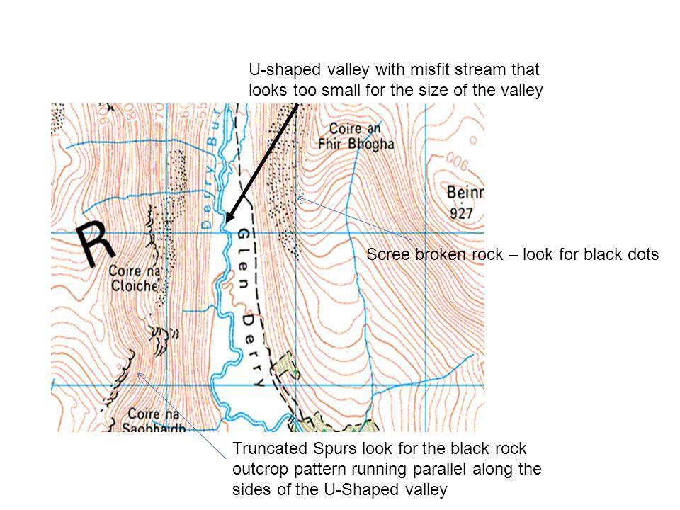
11 Glacial trough (U shaped valley) U shaped valley carved out by a glacier Ribbon lake: A long, narrow lake found in a glacial trough. Explain the formation of a glacial trough/ribbon lake. (4marks) Before glaciation, a river runs through the landscape through a V shaped valley. As the climate gets colder, a glacier forms in the valley by layers of snow building up then becoming compressed into ice. Pieces of rock are added to the glacier through freeze thaw weathering and plucking as the glacier pulls off pieces of rock as it advances. It then scrapes the pieces of rock along the valley bottom and sides, wearing them away into a U shaped valley. This is called abrasion. If part of the valley is made up of softer rock it will erode more deeply. After glaciation this may fill with water creating a long, thin lake.

12 Glacial trough Steep sides. Flat valley bottom. There may be a misfit stream running through the valley

13 (No contours on the valley floor as it is flat.) Stacks
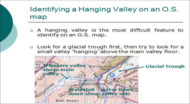
 This forms where a tributary valley flows into a main valley.")
14 Hanging Valley: A smaller valley perched high up on the side of the main valley. This may contain a waterfall. Explain the formation of a Hanging valley (4marks) This forms where a tributary valley flows into a main valley. It is too small to erode very much through abrasion so doesn t erode as deeply as the main glacial valley. When the climate warms up, both glaciers melt leaving the smaller tributary valley perched above the main one. There is often a waterfall where the two valleys join.
15

16 Truncated spurs: A former river valley spur which has been sliced off by a valley glacier, forming clifflike edges. Explain the formation of truncated spurs (4marks). Before glaciation when the climate was warmer, a river followed a winding path down a V shaped valley going around areas of harder rock, called interlocking spurs. As the climate got colder, a glacier filled the old river valley and eroded its way straight through the areas of rock that the river couldn t erode. The glacier cut off the interlocking spurs leaving cliff like edges called truncated spurs.
17
18 Landscapes in the UK: Glaciation 4. Characteristics and formation of landforms caused by deposition: You need to be able to describe the characteristics of and explain the formation of the following glacial landforms: 1. Erratics 2. Drumlins 3. Moraine In order to explain the formation of a landform you need to do two things: 1. Give a full sequence what was needed for the landform to start to be created, then what happened, then what happened, then always say that this repeated over time leaving the landform in the landscape. 2. Name and explain the processes involved. You should also make sure you can draw a sequence of diagrams showing their formation and recognise photographs of the landforms and what they look like on an OS map.
 During glaciation, large chunks of rock can fall on to the glacier broken off by freeze thaw weathering (where water gets into crack in the rock, freezes and expands).")
19 Erratics: What is an erratic? Rocks which have been transported and deposited by a glacier some distance from where they came from. Explain the formation of an erratic. (4marks) During glaciation, large chunks of rock can fall on to the glacier broken off by freeze thaw weathering (where water gets into crack in the rock, freezes and expands). These large rocks are then carried down the valley by the glacier. When the climate warms up the ice melts and can no longer carry the rock so it drops It in an areas with a different rock type. This is an erratic.


20 Drumlins: What are they? An oval hill made of glacial till. (material deposited by a glacier) Explain the formation of a drumlin. (4marks)
21

22 Drumlins on OS maps are lots of tiny rings of contours indicating small hills.

23 Moraine: Material carried aong and then deposited (dropped) by the glacier. Explain the formation of moraine. (4marks) Material is added to a glacier through freeze thaw and plucking. (where the glacier freezes onto rocks on the valley side and the pulls them off as it moves. ) This material is then carried along by the glacier as Lateral moraine (material at the side of the glacier) Medial moraine (material in the centre of the glacier formed when two glaciers and lateral moraines meet.) Terminal moraine (a pile of material at the furthest point of advance of the glacier.) When the climate warms, the glacier melts and can no longer carry the material so it drops it in ridges on the valley floor.

24 Landscapes in the UK: Glaciation 5. An example of a glaciated area in the UK to identify its major landforms of erosion and deposition: The Lake District. The Lake District is an area with many mountains and lakes in northern England. It was once covered by ice which created its landscape. Major landforms of erosion in the Lake District are found in the upland (high up) areas. There is a large corrie at Hellvellyn with a tarn called Red Tarn in it with aretes either side of the corrie where other corries have eroded back to back. These aretes are called Striding Edge and Swirral Edge. There are many glacial troughs throughout the Lake District with beautiful ribbon lakes (hence the name, the Lake District) Lake Coniston is a famous example of a ribbon lake in the Lake District. Landforms of deposition can be found in lower parts of the Lake District although many of them are hard to spot because they have been eroded by rivers or vegetation has grown over them. In Borrowdale, terminal moraines as used as boundaries to fields. Drumlin swarms can be seen at Swindale. Erratics can be found all over lower parts of the Lake District. Some may have been carried all the way from Scotland!!

25 Red Tarn with the arete Striding Edge on its side.

26 Coniston Water, an example of a ribbon lake in the Lake District

27 Erratics can be found all over the Lake District

28 A terminal moraine which now forms the boundary of a field at Borrowdale.
29 Landscapes in the UK: Glaciation Economic activities in glaciated upland areas Key idea: Glaciated upland areas provide opportunities for different economic activities, and management strategies can be used to reduce land use conflicts. What are the main economic activities in upland areas? Tourism Farming Forestry Quarrying It can be difficult to earn a living in upland glaciated areas because of the steep slopes, thin soils and problems with accessibility so these activities are extremely important to these areas.
30 Landscapes in the UK: Glaciation Economic activities in glaciated upland areas Tourism: Often the main source of income in the area as people want to see the mountains and lakes. Provides jobs. Example: Lake District see later notes. Farming: Poor soils in upland areas so mainly used for grazing sheep who tolerate the cold, wet and wind and poor vegetation. In valley bottoms, soils are thicker and machinery can be used on the flat land. Crops include cereals and potatoes.
31 Landscapes in the UK: Glaciation Economic activities in glaciated upland areas Forestry: Forestry is growing trees to then use for timber. Large areas of trees have been planted throughout Scotland and northern England. Conifer trees are well adapted to cope with the bad soils and steep slopes so this is a good way to use land that cannot be used for anything else. The timber is use in constructions and making paper. Quarrying: Quarrying is the digging out of rock from the ground. Upland areas are made of hard, resistant rock which is good for construction and road building. Example: Limestone taken from the Pennines is important in making cement. In lowland areas, sand and gravel which have been deposited by glaciers are also used to make concrete and cement.
32 Landscapes in the UK: Glaciation Conflicts between land uses A conflict is when two or more different groups of people have opposing views as to how the land should be used. Examples of land use conflicts in the Lake District: 1. Tourism and farming often come into conflict. Tourists may trample farmers fields and their dogs may scare the sheep. Often dry stone walls are damaged by tourists climbing over them which will upset farmers. Farmers may stop tourists going on to their land by putting up fences which tourists will be unhappy about. 2. Upland areas are a great place to put dams for HEP. This is good for local businesses and the government who require cheap, green energy sources, however, local people and farmers may have to be relocated to make space for the reservoir behind the dam.
33 Landscapes in the UK: Glaciation Conflicts between development and conservation Development is A country or area making progress in terms of wealth and improving quality of life. Conservation is Managing the environment in order to preserve, protect or restore it. Often these two aims come into conflict as activities that create jobs and opportunities often damage the environment. Examples: 2014 proposal for the Glenridding Zip Wire this would have been an important tourist attraction and brought tourists, money and jobs to the area. However, environmentalists and local people successfully argued that tourists would bring litter, footpath erosion and traffic congestion to the area. The scheme did not go ahead because of the possible impact on the environment.
34 Landscapes in the UK: Glaciation An example of a glaciated upland area used for tourism: The Lake District Attractions of the Lake District to tourism: Physical Attractions: (natural features that make people want to go there) Lakes such as Coniston water provide a location for water sports, cruises and fishing. Mountain landscapes such as the area around Hellvelyn attracts walkers and mountain bikers. Human attractions: Water sports and outdoor activities.. There is lots of culture. Beatrix Potters home called Hill Top now houses a museum. Scenic towns and villages such as Ambleside are enjoyed by tourists.
35 Landscapes in the UK: Glaciation An example of a glaciated upland area used for tourism: The Lake District Impacts of tourism in the Lake District: Economic impacts: 2014 tourists spent 1billion which supports hotels, shops and businesses. Thousands of jobs are available in these businesses. Traffic congestion on the small roads slows down business communication. Social Impacts: Negative impact on local people as tourists disturb local villages. Traffic congestion. 89% of tourists come by car. High house prices because of the demand for property as second homes. This makes housing unaffordable for local people. Jobs in tourism are mostly seasonal, poorly paid and unreliable which has an impact on people s quality of life.
36 Landscapes in the UK: Glaciation An example of a glaciated upland area used for tourism: The Lake District Impacts of tourism in the Lake District: Environmental impacts of tourism: Honeypot sites such as Cat Bells (a small hill that people like to climb) and Beatrix Potters House, Hill Top are showing signs of overcrowding with footpath erosion, litter and damage to grass verges by cars.. Air pollution and oil from vehicles and oil from boats can damage ecosystems. Walkers can damage farmland by trampling crops or leaving litter. Dogs can disturb sheep or cattle. Remember, if asked to discuss the impacts you can: Give positive and negative impacts. Give economic, social and environmental impacts.
37 Landscapes in the UK: Glaciation An example of a glaciated upland area used for tourism: The Lake District Managing tourism in the Lake District: How can traffic congestion be managed? There are many successful strategies in the Lake District. Several dual carriageways have been built around the Lake District to imprave access. Park and ride bus schemes such as the Hositer Rambler have been introduced to take people to honeypot sites in buses rather than all going separately in their cars. Speed bumps have been introduced in villages. Overall the use of public transport has been very successful however roads will be put under increasing pressure with increased visitor numbers into the future. How can footpath erosion be managed? The Upland Path Landscape Restoration project has successfully repaired paths, created steps, resurfaced paths with local stone and replanted native plants. Fix the Fells repair and maintain mountain paths supported by well funded organizations such as the national trust. The schemes have been very successful however, there are still hundreds of km in need of constant attention and their ongoing maintenance provides a huge challenge.
38 Landscapes in the UK: Glaciation An example of a glaciated upland area used for tourism: The Lake District As we have seen, managing environmental problems is fairly straightforward and has been successful, The problem of second homes in the Lake District forcing up house prices is much more difficult to address and is likely to remain an issue into the future.
Landscapes in the UK: Glaciation 1. Extent of ice cover across the UK during the last ice age.
 Landscapes in the UK: Glaciation 1. Extent of ice cover across the UK during the last ice age. Key idea: Ice was a powerful force in shaping the landscape of the UK. As the climate has changed in the past,
Unit 1: Physical Environment Glaciated Landscapes
 Unit 1: Physical Environment Glaciated Landscapes Corries Corries are bowl-shaped hollows high up in the mountains. They are formed in the following way: Snow collects in a hollow on a mountainside (usually
Red Tarn, Lake District They are all features of glacial erosion
 Ribbon Lake Lake Windermere, Lake District Arete Striding Edge, Lake District 1 2 3 Pyramidal Peak Corrie & Tarn 4 Matterhorn, Switzerland Red Tarn, Lake District They are all features of glacial erosion
Mearns Castle High School. Geography Department. Glaciated Landscapes
 Mearns Castle High School Geography Department Glaciated Landscapes Lesson One: Location of Glaciated Uplands in the British Isles The Ice Age in Britain began about 1,000,000 years ago and lasted until
Q: What is a period of time whereby the average global temperature has decreased? Q: What is a glacier?
 Q: What is a glacier? A: A large sheet of ice which lasts all year round. Q: What is a period of time whereby the average global temperature has decreased? A: A glacial. Q: What is an interglacial? Q:
Formation of a Corrie
 Formation of a Corrie A corrie looks rather like a armchair has been cut out of the rock face When a hill has been heavily eroded with 3 or 4 corries the jagged hill that is left is known as a pyramidal
PHYSICAL GEOGRAPHY GEOGRAPHY EARTH SYSTEMS COASTAL SYSTEMS FLUVIAL SYSTEMS
 PHYSICAL GEOGRAPHY EARTH SYSTEMS FLUVIAL SYSTEMS COASTAL SYSTEMS PHYSICAL GEOGRAPHY CORRIES / CIRQUES A Corrie or Cirque is the armchair shaped hollow that was the birthplace of a glacier. It has steep,
1. Study the Ordnance Survey Map of Brodick, Isle of Arran.
 1. Study the Ordnance Survey Map of Brodick, Isle of Arran. To find the map go to: > http://www.bing.com/maps/ > change maps type to Ordnance Survey Map from Road. > search for Glenrosa Water (it is near
1.4 Understand how moving ice acts as an agent of erosion and deposition. (Chap. 2)
") 1.4 Understand how moving ice acts as an agent of erosion and deposition. (Chap. 2) There are two types of glaciation. Alpine Glaciation Continental Glaciation Distinguish between the terms alpine glaciation
1.4 Understand how moving ice acts as an agent of erosion and deposition. (Chap. 2) There are two types of glaciation. Alpine Glaciation Continental Glaciation Distinguish between the terms alpine glaciation
1 Glacial Erosion and
 www.ck12.org Chapter 1. Glacial Erosion and Deposition CHAPTER 1 Glacial Erosion and Deposition Lesson Objectives Discuss the different erosional features formed by alpine glaciers. Describe the processes
Making glacial connections
 Student task A 1. Cut and arrange the cards below to make four sets of four connections: Four connections Matterhorn drumlin lateral U-shaped valley outwash plain truncated spur Lauterbrunnen ground medial
How this guide works...
 How this guide works... This guide is the ice on the land revision guide and should be used alongside the exam question booklet you got last term. Together it gives you a full and detailed guide of everything
Chapter 16 Glaciers and Glaciations
 Chapter 16 Glaciers and Glaciations Name: Page 419-454 (2nd Ed.) ; Page 406-439 (1st Ed.) Part A: Anticipation Guide: Please read through these statements before reading and mark them as true or false.
What would you say was the extend of the ice cover? 100%? 50%? A third? 2/3?
 This map shows the maximum extent of ice cover during the last ice age, 20,000 years ago. What would you say was the extend of the ice cover? 100%? 50%? A third? 2/3? KEY IDEAS & QUESTIONS What is a glacier?
GCSE Geography for AQA specification B. Sample Chapter
 SAMPLE CHAPTER GCSE Geography for AQA specification B Janet Helm and Arthur Robinson Pupil book ISBN: 0435 35358 6 Sample Chapter This sample contains chapter 3 from the GCSE Geography for AQA B pupil
I. Types of Glaciers 11/22/2011. I. Types of Glaciers. Glaciers and Glaciation. Chapter 11 Temp. B. Types of glaciers
 Why should I care about glaciers? Look closely at this graph to understand why we should care? and Glaciation Chapter 11 Temp I. Types of A. Glacier a thick mass of ice that originates on land from the
glacier Little Ice Age continental glacier valley glacier ice cap glaciation firn glacial ice plastic flow basal slip Chapter 14
 Little Ice Age glacier valley glacier continental glacier ice cap glaciation firn glacial ice plastic flow basal slip glacial budget zone of accumulation zone of wastage glacial surge abrasion glacial
GLACIATION. The Last Ice Age (see Chapter 12) and. Pleistocene Ice Cap. Glacial Dynamics 10/2/2012. Laurentide Ice Sheet over NYS
 and. Pleistocene Ice Cap. Glacial Dynamics 10/2/2012. Laurentide Ice Sheet over NYS") GLACIATION and New York State Prof. Anthony Grande The Last Ice Age (see Chapter 1) The Pleistocene Epoch began 1.6 mya. During this time, climates grew colder. There were numerous ice ages starting 100,000000
GLACIATION and New York State Prof. Anthony Grande The Last Ice Age (see Chapter 1) The Pleistocene Epoch began 1.6 mya. During this time, climates grew colder. There were numerous ice ages starting 100,000000
Shaping of North America. Physical Geography II of the United States and Canada. The Last Ice Age. The Ice Age. Pleistocene Polar Ice Cap 2/14/2013
 Physical Geography II of the United States and Canada Prof. Anthony Grande AFG 2012 Shaping of North America The chief shaper of the landscape of North America is and has been running water. Glaciation
How Glaciers Change the World By ReadWorks
 How Glaciers Change the World How Glaciers Change the World By ReadWorks Glaciers are large masses of ice that can be found in either the oceans or on land. These large bodies of frozen water have big
Glaciers Earth 9th Edition Chapter 18 Mass wasting: summary in haiku form Glaciers Glaciers Glaciers Glaciers Formation of glacial ice
 1 2 3 4 5 6 7 8 9 10 11 12 13 14 15 Earth 9 th Edition Chapter 18 Mass wasting: summary in haiku form Ten thousand years thence big glaciers began to melt - called "global warming." are parts of two basic
Glaciers and Glaciation Earth - Chapter 18 Stan Hatfield Southwestern Illinois College
 Glaciers and Glaciation Earth - Chapter 18 Stan Hatfield Southwestern Illinois College Glaciers Glaciers are parts of two basic cycles: 1. Hydrologic cycle 2. Rock cycle A glacier is a thick mass of ice
Recrystallization of snow to form LARGE. called FIRN: like packed snowballs. the weight of overlying firn and snow.
 Chapter 11 Glaciers BFRB P. 103-104, 104, 108, 117-120120 Process of Glacier Formation Snow does NOT melt in summer Recrystallization of snow to form LARGE crystals of ice (rough and granular) called
Great Science Adventures
 Great Science Adventures Lesson 18 How do glaciers affect the land? Lithosphere Concepts: There are two kinds of glaciers: valley glaciers which form in high mountain valleys, and continental glaciers
Geologic Trips, Sierra Nevada
 ISBN 0-9661316-5-7 GeoPress Excerpt from Geologic Trips, Sierra Nevada by Ted Konigsmark All rights reserved. No part of this book may be reproduced without written permission, except for critical articles
Mighty Glaciers. Mighty Glaciers. Visit for thousands of books and materials.
 Mighty Glaciers A Reading A Z Level M Leveled Reader Word Count: 684 LEVELED READER M Mighty Glaciers Written by Ned Jensen Visit www.readinga-z.com for thousands of books and materials. www.readinga-z.com
Chapter 14. Glaciers and Glaciation
 Chapter 14 Glaciers and Glaciation Introduction Pleistocene Glaciations: A series of "ice ages" and warmer intervals that occurred 2.6 million to 10,000 years ago. The Little Ice Age was a time of colder
Darwin s gigantic blunder
 Trail Darwin s gigantic blunder Explore how ice shaped the landscape and why Charles Darwin made a nice mess of Glen Roy Time: 1hr 10 mins Distance: 2 miles Landscape: rural At Glen Roy a curious feature
The Physical Geography of Long Island
 The Physical Geography of Long Island A Bit About Long Island Length 118 miles Brooklyn to Montauk Geo202 Spring 2012 Width 23 miles at it s widest Area 1,400 square miles Formation of Long Island River
Glaciers. Chapter 17
 Glaciers Chapter 17 Vocabulary 1. Glacier 2. Snowfield 3. Firn 4. Alpine glacier 5. Continental glacier 6. Basal slip 7. Internal plastic flow 8. Crevasses 9. Glacial grooves 10. Ice shelves 11. Icebergs
2. (1pt) From an aircraft, how can you tell the difference between a snowfield and a snow-covered glacier?
 From an aircraft, how can you tell the difference between a snowfield and a snow-covered glacier?") 1 GLACIERS 1. (2pts) Define a glacier: 2. (1pt) From an aircraft, how can you tell the difference between a snowfield and a snow-covered glacier? 3. (2pts) What is the relative size of Antarctica, Greenland,
1 GLACIERS 1. (2pts) Define a glacier: 2. (1pt) From an aircraft, how can you tell the difference between a snowfield and a snow-covered glacier? 3. (2pts) What is the relative size of Antarctica, Greenland,
Lornshill Academy. Geography Department Higher Revision Physical Environments - Lithosphere
 Lornshill Academy Geography Department Higher Revision Physical Environments - Lithosphere Physical Environments Lithosphere Formation of erosion and depositional features in coastal landscapes Processes
Dynamic Planet C Test
 Northern Regional: January 19 th, 2019 Dynamic Planet C Test Name(s): Team Name: School Name: Team Number: Rank: Score: Dynamic Planet B/C Glaciers (87 total points) Multiple choice/fill in the blank (23
Glaciers. Clicker Question. Glaciers and Glaciation. How familiar are you with glaciers? West Greenland. Types of Glaciers.
 Chapter 21 Glaciers A glacier is a large, permanent (nonseasonal) mass of ice that is formed on land and moves under the force of gravity. Glaciers may form anywhere that snow accumulation exceeds seasonal
READING QUESTIONS: Chapter 7, Glaciers GEOL 131 Fall pts. a. Alpine Ice from larger ice masses flowing through a valley to the ocean
 READING QUESTIONS: Chapter 7, Glaciers GEOL 131 Fall 2018 63 pts NAME DUE: Tuesday, October 23 Glaciers: A Part of Two Basic Cycles (p. 192-195) 1. Match each type of glacier to its description: (2 pts)
Did It. naturalists. Young. Moving and melting ice shaped many of Minnesota s land features. 30 Minnesota Conservation Volunteer
 Young naturalists by Mary Hoff Photography by Gary Alan Nelson T he Glacier Did It Moving and melting ice shaped many of Minnesota s land features. Shut your eyes. Imagine that it s a sunny summer day
READING QUESTIONS: Glaciers GEOL /WI 60 pts. a. Alpine Ice from larger ice masses flowing through a valley to the ocean
 READING QUESTIONS: Glaciers GEOL 131 18/WI 60 pts NAME DUE: Tuesday, March 13 Glaciers: A Part of Two Basic Cycles (p. 192-195) 1. Match each type of glacier to its description: (2 pts) a. Alpine Ice from
ENVI2030L - ALPINE AND CONTINENTAL GLACIATION
 NAME ENVI2030L - ALPINE AND CONTINENTAL GLACIATION I. Introduction Glaciers are slowly moving ice sheets. They are very effective erosional agents and can drastically modify the landscapes over which they
MIDDLE SCHOOL CURRICULUM TR AILING ICE AGE M YST ERI E S SEARCHING GLACIAL FEATURES
 MIDDLE SCHOOL CURRICULUM TR AILING ICE AGE M YST ERI E S SEARCHING GLACIAL FEATURES CONTENTS I. Enduring Knowledge... 3 II. Teacher Background... 3 III. Before Viewing the Video... 5 IV. Viewing Guide...
Glaciers. Glacier Dynamics. Glacier Dynamics. Glaciers and Glaciation. Types of Glaciers. Chapter 15
 Chapter 15 Glaciers and Glaciation Glaciers A glacier is a large, permanent (nonseasonal) mass of ice that is formed on land and moves under the force of gravity. Glaciers may form anywhere that snow accumulation
MIDDLE SCHOOL CURRICULUM TR AILING ICE AGE M YST ERI E S ICE AGE TREKKING
 MIDDLE SCHOOL CURRICULUM TR AILING ICE AGE M YST ERI E S ICE AGE TREKKING CONTENTS I. Enduring Knowledge... 3 II. Teacher Background... 3 III. Before Viewing this Video... 5 IV. Viewing Guide... 5 V. Discussion
Glaciers. Reading Practice
 Reading Practice A Glaciers Besides the earth s oceans, glacier ice is the largest source of water on earth. A glacier is a massive stream or sheet of ice that moves underneath itself under the influence
Physical Environments: Glaciation. Land Use Conflict in the Lake District
 Physical Environments: Glaciation Land Use Conflict in the Lake District Locating the Lake District Identify and locate the Lake District on your blank UK map. Use an atlas to comment on its site and surroundings
Glaciers and Glaciation
 Chapter 18 Lecture Earth: An Introduction to Physical Geology Eleventh Edition Glaciers and Glaciation Tarbuck and Lutgens Glaciers: A Part of Two Basic Cycles A glacier is a thick mass of ice that forms,
Glaciers and Periglaciers
 Glaciers and Periglaciers Chapter 9, page 132 Glaciation!1836 Louis Agassiz theorized that parts of Europe and North America were covered by huge ice sheets.!known as the Pleistocene Ice Ages Why do we
Glaciers. Glacier Dynamics. Glaciers and Glaciation. East Greenland. Types of Glaciers. Chapter 16
 Chapter 16 Glaciers A glacier is a large, permanent (nonseasonal) mass of ice that is formed on land and moves under the force of gravity. Glaciers may form anywhere that snow accumulation exceeds seasonal
Alpine Glacial Features along the Chimney Pond Trail, Baxter State Park, Maine
 Maine Geologic Facts and Localities September, 2009 Alpine Glacial Features along the Chimney Pond Trail, Baxter State Park, Maine 45 54 57.98 N, 68 54 41.48 W Text by Robert A. Johnston, Department of
Teacher s Guide For. Glaciers
 Teacher s Guide For Glaciers For grade 7 - College Program produced by Centre Communications, Inc. for Ambrose Video Publishing, Inc. Executive Producer William V. Ambrose Teacher's Guide by Mark Reeder
RURAL LAND RESOURCES Case study area 1- the erosional features of the Dorset Coast.
 Case study area 1- the erosional features of the Dorset Coast. Scene setting;- This area lies on the far south coast of England, between the settlements of Lyme Regis and Bournemouth, in the county of
Gifts of the Glaciers
 Gifts of the Glaciers Gifts of the Glaciers Moving ice of glacier was responsible for water, landforms, and soil characteristics and patterns of today Sculpturing of bedrock materials Glacial Landforms
Please make sure that all teachers and chaperones attending the field study are aware of the following information:
 Dear Teacher, Thank you for signing up for The Ice Age at the Lost Valley Visitor Center in Glacial Park. The visitor center is located in the middle of Glacial Park. Follow the signs from the Harts Road
Parts of a Glacier Division A Study Guide- Part 2
 Parts of a Glacier Division A Study Guide- Part 2 Zones of a glacier Zone of Accumulation: The region where snowfall adds ice to the glacier. It occurs where the temperature remains cold enough year-round
Lesson. Glaciers Carve the Land A QUICK LOOK. Overview. Big Idea. Process Skills Key Notes
 EARTH S CHANGING SURFACE CLUSTER 2 HOW THE EARTH S SURFACE CHANGES Lesson 62 Glaciers Carve the Land A QUICK LOOK Big Idea Moving water, ice, and wind break down rock, transport materials, and build up
There are actually six geographic sub-regions, three in both the uplands and the lowlands.
 6 Regions of AR Although Arkansas is most easily divided into two distinct geographical regions, the northwestern uplands and the southeastern lowlands, this description does not accurately portray the
LAB P - GLACIAL PROCESSES AND LANDSCAPES
 Introduction LAB P - GLACIAL PROCESSES AND LANDSCAPES Ice has been a significant force in modifying the surface of the earth at numerous times throughout Earth s history. Though more important during the
Chapter 17. Glacial & Periglacial Landscapes
 Chapter 17 Glacial & Periglacial Landscapes Cryosphere Cryosphere - the portions of Earth's surface where water is in solid form, including sea ice, lake ice, river ice, snow cover, glaciers, ice caps,
Name Team Number. 1. The famous question: What percent of Earth's surface is covered by glaciers? A) 5% D) neve
 5% D) neve") Part I: Multiple Choice (30pts) Directions: Please choose the best answer for each question. There is only one correct answer for each question unless otherwise stated. There are 30 questions. Each one
Part I: Multiple Choice (30pts) Directions: Please choose the best answer for each question. There is only one correct answer for each question unless otherwise stated. There are 30 questions. Each one
Kindergarten Science Unit C: Earth Science Chapter 5: Our Land, Air, and Water Lesson 1: What makes up the Earth?
 Insert Photo or Graphic for Unit or Lesson Theme Kindergarten Science Unit C: Earth Science Chapter 5: Our Land, Air, and Water Lesson 1: What makes up the Earth? Insert Photo/Graphic Earth Insert Photo/Graphic
BISHOPSTONE CIRCULAR WALK
 BISHOPSTONE CIRCULAR WALK 4½ miles (7¼ km) - allow 2 hours (see maps on final pages) Introduction This walk is within the North Wessex Downs Area of Outstanding Natural Beauty and starts from the small,
Geography 120, Instructor: Chaddock In Class 13: Glaciers and Icecaps Name: Fill in the correct terms for these descriptions: Ablation zone: n zne:
 Geography 120, Instructor: Chaddock In Class 13: Glaciers and Icecaps Name: Fill in the correct terms for these descriptions: Ablation zone: The area of a glacier where mass is lost through melting or
Changing Landscapes: Glaciated Landscapes. What are glaciers?
 Changing Landscapes: Glaciated Landscapes What are glaciers? What you need to know Types of ice mass at a range of scales including cirque glaciers, valley glaciers, highland ice field, piedmont glaciers,
Glaciers. Valley or Alpine glaciers. Ice sheets. Piedmont - foot of the mountain glaciers. Form in mountainous areas Move downslope in valleys
 Glaciers & Ice Ages Glaciers Valley or Alpine glaciers Form in mountainous areas Move downslope in valleys Ice sheets Move outward from center Continental glaciers - large scale, ice age type. Presently
Glaciers Earth Chapter 18 Chapter 18 Glaciers & Glaciation Glaciers: A Part of Two Basic Cycles Glaciers: A Part of Two Basic Cycles Valley Glacier
 1 2 3 4 5 6 7 8 9 10 11 12 Glaciers Earth Chapter 18 Chapter 18 Glaciers & Glaciation A glacier is a thick mass of ice that forms, over hundreds and thousands of years, by the accumulation, compaction,
THE DEPARTMENT OF HIGHER EDUCATION UNIVERSITY OF COMPUTER STUDIES FIFTH YEAR
 THE DEPARTMENT OF HIGHER EDUCATION UNIVERSITY OF COMPUTER STUDIES FIFTH YEAR (B.C.Sc./B.C.Tech.) RE- EXAMINATION SEPTEMBER 2018 Answer all questions. ENGLISH Time allowed: 3 hours QUESTION I Glaciers A
GCSE Geography A. Mark Scheme for June Unit A732/02: Geographical skills (Higher Tier) General Certificate of Secondary Education
 General Certificate of Secondary Education") GCSE Geography A Unit A732/02: Geographical skills (Higher Tier) General Certificate of Secondary Education Mark Scheme for June 2016 Oxford Cambridge and RSA Examinations OCR (Oxford Cambridge and RSA)
GCSE Geography A Unit A732/02: Geographical skills (Higher Tier) General Certificate of Secondary Education Mark Scheme for June 2016 Oxford Cambridge and RSA Examinations OCR (Oxford Cambridge and RSA)
Dynamic Planet: Glaciers
 Team Name+Number Teammate 1 name Teammate 2 name Dynamic Planet: Glaciers (by Shad160) The following test is 80 questions long, split up into four different sections. The first 20 questions are worth 40
Just to the left of the trail head sign and across the dirt road, please notice a granite post. Well
 Rice Natural Area TWO BROOKS TRAIL TRAILS WITH TALES, #1 Introduction The land you are about to enter is a quiet place. It is also quite extraordinary. Enjoy your visit. To understand the tale of Two Brooks
Introduction to Safety on Glaciers in Svalbard
 Introduction to Safety on Glaciers in Svalbard Content Basic info on Svalbard glaciers Risk aspects when travelling on glaciers Safe travel on glaciers UNIS safety & rescue equipment Companion rescue in
Limestone terraces (in the distance) and woodland on hills in the Upper Wharfedale valley
 and woodland on hills in the Upper Wharfedale valley") GRASSINGTON North Yorkshire from www.discoverbutterflies.com the website for the book Discover Butterflies in Britain D E Newland 2009 Limestone terraces (in the distance) and woodland on hills in the
GRASSINGTON North Yorkshire from www.discoverbutterflies.com the website for the book Discover Butterflies in Britain D E Newland 2009 Limestone terraces (in the distance) and woodland on hills in the
Lidar Imagery Reveals Maine's Land Surface in Unprecedented Detail
 Maine Geologic Facts and Localities December, 2011 Lidar Imagery Reveals Maine's Land Surface in Unprecedented Detail Text by Woodrow Thompson, Department of Agriculture, Conservation & Forestry 1 Introduction
Global Growth of Tourism Revision Worldwide tourism has grown a lot in the last 50years. Add as many reasons why to the spider diagram below.
 Global Growth of Tourism Revision Worldwide tourism has grown a lot in the last 50years. Add as many reasons why to the spider diagram below Economic Social Worldwide growth in tourism Environmental Exam
Wicklow Mountains Path Survey
 Wicklow Mountains Path Survey Glenmacnass Tonelagee Start to Finish: O 114 030 to O 085 016 Altitude (lowest highest): 370m 817m Weather: Sunny day, hot Access: Military Road, Glenmacnass Surveyed by:
Tuesday 19 May 2015 Afternoon
 Oxford Cambridge and RSA F Tuesday 19 May 2015 Afternoon GCSE GEOGRAPHY A A731/01 Contemporary Themes in Geography (Foundation Tier) *2789690473* Candidates answer on the Question Paper. OCR supplied materials:
glacial drift: all deposits associated with glaciation; covers 8% of Earth s surface above sealevel, and 25% of North America
 Glacial depositional features glacial drift: all deposits associated with glaciation; covers 8% of Earth s surface above sealevel, and 25% of North America i) nonstratified drift till: transported & deposited
Property access tracks
 Property access tracks Planning, location, construction and maintenance The need for farm roads and tracks The efficient running of a property depends on, among other things, ready access to various locations
3rd GRADE MINIMUM CONTENTS UDI 1: LANDSCAPES (5)
") 3rd GRADE MINIMUM CONTENTS UDI 1: LANDSCAPES (5) DIFFERENT LANDSCAPES A landscape is all the things that we see in a place. There are different types of landscapes. Mountain landscapes have mountains and
3rd GRADE MINIMUM CONTENTS UDI 1: LANDSCAPES (5) DIFFERENT LANDSCAPES A landscape is all the things that we see in a place. There are different types of landscapes. Mountain landscapes have mountains and
Dynamic Planet Practice Test Written by Samuel Bressler
 Dynamic Planet Practice Test 2013 Written by Samuel Bressler Part 1: Multiple Choice 1. Which of the following is NOT related to alpine glaciation? a) Serac b) Kame c) Col d) Paternoster Lake 2. The common
Canon Slade School Geography Department Unit 2 Revision Case Studies Tourism
 Canon Slade School Geography Department Unit 2 Revision Case Studies Tourism 1 Case Study of a UK National Park: the Lake District The Lake District is a national park in Cumbria. Attractions are either
Aira Force & Ullswater Access Statement
 Aira Force & Ullswater Access Statement Aira Force, Watermillock, Penrith, CA11 0JS T: 017684 82067 E: ullswater@nationaltrust.org.uk Section 1: Aira Force Section 2: Ullswater Countryside Section 1: Aira
Region 1 Piney Woods
 Region 1 Piney Woods Piney Woods 1. This ecoregion is found in East Texas. 2. Climate: average annual rainfall of 36 to 50 inches is fairly uniformly distributed throughout the year, and humidity and temperatures
Just how big is Africa?
 The United States China India The United Kingdom Portugal Spain France Belgium Germany The Netherlands Switzerland Italy Eastern Europe Japan 11.7 million sq. miles Just how big is Africa? Chapter 18 Section
Specification for Grip blocking using Peat Dams
 Technical Guidance Note 1 Specification for Grip blocking using Peat Dams 1. Introduction Moorland drains (grips) have been dug across much of the Yorkshire upland peatlands. Many of these grips have become
INTERPRETING TOPOGRAPHIC MAPS (MODIFIED FOR ADEED)
") INTERPRETING TOPOGRAPHIC MAPS (MODIFIED FOR ADEED) Science Concept: Topographic maps give information about the forces that shape the features of Earth. Objectives: The student will: identify land features
INTERPRETING TOPOGRAPHIC MAPS (MODIFIED FOR ADEED) Science Concept: Topographic maps give information about the forces that shape the features of Earth. Objectives: The student will: identify land features
For Creative Minds. Glaciers
 For Creative Minds The For Creative Minds educational section may be photocopied or printed from our website by the owner of this book for educational, non-commercial uses. Cross-curricular teaching activities,
Glacial Geomorphology Exercise
 James Madison University Field Course in western Ireland Glacial Geomorphology Exercise 3-day road log (abbreviated) Striations Large kame terrace Cirque with moraines Kame delta Striations Eskers Raised
NYS Invitational Science Olympiad April 2005 DYNAMIC PLANET: GLACIERS
 NYS Invitational Science Olympiad April 2005 School Team # DYNAMIC PLANET: GLACIERS 1. What type of glacier is shown in the photo? 2. a. What is the name of the feature labeled A? b. How did feature A
Geoscape Toronto The Oak Ridges Moraine Activity 2 - Page 1 of 10 Information Bulletin
 About 13,000 years ago as the Laurentide Ice Sheet melted, glacial meltwater accumulated between the ice sheet and the Niagara Escarpment. This formed a lake basin into which gravel and sand were deposited.
The Story of Stickeen
 r4 WT/Math/Rdg Rel '03 4/3/03 11:55 AM Page 65 Read this selection. Then answer the questions that follow it. The Story of Stickeen John Muir (1838 1914) was a well-known author and explorer who helped
Brain Wrinkles. Africa: The impact of location, climate, & physical characteristics on where people live, the type of work they do, & how they travel
 Africa: The impact of location, climate, & physical characteristics on where people live, the type of work they do, & how they travel STANDARDS: SS7G3 The student will explain the impact of location, climate,
Waterproof Debris Shelter
 Bushcraft Video Series: David Styles, creator of 'Deep Nature Mentoring' presents Waterproof Debris Shelter Transcript Of Video 1. How Do We Make A Debris Shelter? Today we are going to learn about how
Guthega to Mt Twynam. 2183m. 1583m. 6 hrs 45 mins 14.8 km Return. Experienced only. 913m
 Guthega to Mt Twynam 6 hrs 45 mins 14.8 km Return Experienced only 5 913m This walk starts from Guthega and makes its way along the Snowy River to the Illawong Lodge, via the Blue Cow Creek flying fox.
Lornshill Academy. Geography Department. National 5 Revision
 Lornshill Academy Geography Department National 5 Revision Physical Environments Glaciated Uplands Processes of Erosion Physical Weathering (Freeze-Thaw Weathering) Rainwater enters cracks in rocks and,
Girrakool to Wondabyne station via Pindar caves
 Girrakool to Wondabyne station via Pindar caves 7 hrs 30 mins 18.1 km One way Experienced only 5 741m This walk starts from the Girrakool picnic area and winds south, following Piles creek into the Brisbane
What Is An Ecoregion?
 Ecoregions of Texas What Is An Ecoregion? Ecoregion a major ecosystem with distinctive geography, characteristic plants and animals, and ecosystems that receives uniform solar radiation and moisture Sometimes
FOOTPATH MANAGEMENT IN ICELAND A VISUAL REFLECTION ON QUALITY CONCERNS AND FOOTPATH POLICY CONSIDERATIONS
 FOOTPATH MANAGEMENT IN ICELAND A VISUAL REFLECTION ON QUALITY CONCERNS AND FOOTPATH POLICY CONSIDERATIONS ANDRÉS ARNALDS DECEMBER 2016 INTRODUCTION It is evident that Iceland is facing tremendous work
CWMGIEDD FROM ABERCRAVE
 Abercrave to Cwmgiedd Walk Page 1 Starting from The Abercrave Inn. Grid Ref: SN 824128 From the Abercrave Inn, an 11.3km (7 miles) walk to the foothills of the Cribarth Mountain, then through forest to
GC 225 Lecture Exam #2
 GC 225 Lecture Exam #2 Direction- path along which something is moving. 3 Types; - COMPASS DIRECTIONAL NAME (32 in total) - BEARING (four 0 o - 90 o ) - AZIMUTHS (0 o - 360 o ) Compass (32 named points)
Student Reading 13.10: The Regions of Ohio
 Student Reading 13.10: The Regions of Ohio Ohio has five natural regions which formed more than 10,000 years ago. A natural region is an area that shares the same natural features. These places have similar
Introduction to Africa
 Introduction to Africa Did you know? Africa has more countries than any other continent. The Sahara is a desert that is the size of the U.S. It s the world's largest desert. Most of the world s gold and
Self-Guided Walk Langdale Pikes. Start & Finish: NT car park (free to members) at Sticklebarn - on the right just beyond the New Dungeon Ghyll hotel.
 at Sticklebarn - on the right just beyond the New Dungeon Ghyll hotel.") Self-Guided Walk Langdale Pikes Key Information These mountains form a collection of spires and cliffs on the north side of Langdale. This walk visits four of the main tops Pavey Ark, Harrison Stickle,
Self-Guided Walk Langdale Pikes Key Information These mountains form a collection of spires and cliffs on the north side of Langdale. This walk visits four of the main tops Pavey Ark, Harrison Stickle,