Please make sure that all teachers and chaperones attending the field study are aware of the following information:
|
|
|
- Bathsheba Conley
- 6 years ago
- Views:
Transcription


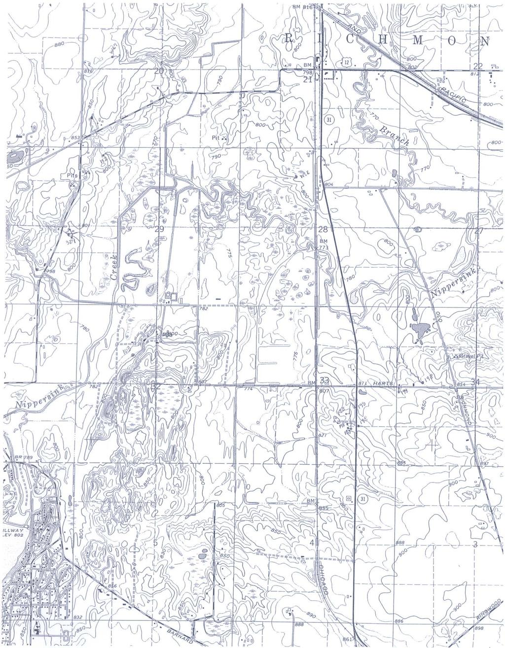
1 Dear Teacher, Thank you for signing up for The Ice Age at the Lost Valley Visitor Center in Glacial Park. The visitor center is located in the middle of Glacial Park. Follow the signs from the Harts Road entrance. If you need further instructions on how to get here please contact us at In the event of inclement weather on the day of your field study, please call us to discuss the day s plans. Please make sure that all teachers and chaperones attending the field study are aware of the following information: 1. Your field study consists of two halves; one indoor and one outdoor. The first 1.5 hours consist of a variety of indoor lessons on glacial geology. Instructors use PowerPoint, video, lecture, and worksheets to teach about geological timelines, ice age origin and geography, and glacial landforms. The second half of the field study consists of a 2 mile hike through the park, exploring various glacial formations. A lunch break in between the two segments will be given at a picnic area outside if weather allows but there is indoor space available if necessary. 2. Teachers, chaperones, and students should dress for the weather including appropriate footwear for hiking over hilly terrain. Fall weather is variable and while it may feel warm at school, Glacial Park tends to be windy and cooler because of the hills. Students should be encouraged to bring layers, including jackets, hats, and gloves. 3. Encourage everyone to bring a waste-free lunch! Pack lunches in insulated containers and include items that can be eaten in their entirety, recycled or composted. Examples are whole fruits and vegetables, drinks in reusable bottles, snacks purchased in bulk and brought in a reusable container, cloth napkins, and reusable ice packs. 4. Background information as well as pre and post-trip activities are available for this and other McHenry County Conservation District school field studies in your choice of format. Completion of the activities ensures a more successful learning experience for your students. Download information from our website at Request that information be sent to your or school address. Call Kim Compton or Andrew Zeiger at Again, we thank you for your interest in the McHenry County Conservation District. We are looking forward to a day of fun and learning with your class. Should you have any questions, please feel free to call us. Sincerely, Kim Compton and Andrew Zeiger Lost Valley Visitor Center Education Program Staff
2 Pre-Trip Activities The Ice Age at Glacial Park Pre-Trip and Post-Trip Activities 1. Complete the Glacial Landforms Crossword activity. A copy and teacher s key is enclosed. 2. Glacier Formation From Earth Science. Namowitz & Spaulding. D.C. Heath and Co., Glaciers form from snow. To see how solid ice can form from snow, take a handful of snow or shaved ice and squeeze it between your hands. Keep applying pressure until you notice a change in the snow or ice particles. What does squeezing seem to do to the particles of snow or ice? What happens when you stop applying pressure? What would cause the packing of snow to form glaciers? How is this activity different from how a glacier forms? 3. Ice on the Move from Ranger Rick s Nature Scope: Geology The Active Earth. National Wildlife Federation, What you need: sand, several flat pieces of shale or limestone, ice cubes, 2 paper towels, water, ice cube tray, a freezer. What to do: Mix several teaspoons of sand with water, and pour the mixture into ice cube trays and freeze. Use a paper towel to pick up one of the sandy ice cubes. Hold the ice tightly against a piece of shale or limestone and slowly push it across the rock several times. Examine the surface of the rock. Do the same thing with a regular ice cube on another piece of rock. What to think about: How do the rock surfaces compare? From what you know about glaciers, how does this experiment explain how glaciers help shape the land? Explain your answer. (Teachers) What should have happened: The ice cube with the sand acts like sandpaper and should leave scratches on the rock surfaces. The control should not be scratched. When glaciers move across land, they pick up and move rock material. Some of this rock material can scratch and gouge rock surfaces. These are called striations. 4. Read The Life of a Glacier at this website: This information may be useful as background information for you or your entire class. Post-Trip Activities 1. Do the enclosed activity entitled The Contour Connection, taken from Ranger Rick s Nature Scope: Geology The Active Earth. National Wildlife Federation, This activity will introduce students to contour mapping of landforms. Once they have completed the first two examples in the book, have them draw contour examples of some glacial landforms moraines, kettles, drumlins, etc. You could also use the activity we completed during the field trip to have the students draw a map with multiple features. 2. Using the enclosed topographic map of Glacial Park, have the students locate the kettles and kames they visited during their trip to Glacial Park. Can they locate any other similar landforms in the area? Locate a topographic map of your school s region, or the area where the students live. What do the landforms tell them about that local area?
3 Glacial Landforms Crossword Across Down 7 Words Crevasse Drift End Erratic Esker Glacier Ground Moraine Ice Front Kames Kettle Lateral Moraine Moraine Outwash Recessional Striations Terminal Till 3. The is a layer of material left behind when a glacier melts 5. A is a huge crack in a glacier 8. A is an accumulation of glacial till 9. An is a long ridge of outwash from subglacial streams 11. are glacial hills formed by meltwater depositing drift at the ice front or in a crevasse 13. The farthest edge of a glacier is called the 14. is unsorted rock material deposited directly by the ice 15. A is a massive sheet of ice formed from snow under extreme pressure 16. End moraine marking a glacier s farthest advance is called the moraine 1. An moraine forms a ridge of till along the ice front when the glacier is stalled 2. A is formed at the sides of a glacier 4. is sorted deposits made by streams of glacial meltwater 6. are long scratches on the bedrock that are parallel to the direction of ice flow 7. moraines are end moraines behind the terminal moraine 10. All deposits of glacial origin are called 11. An ice block buried in a moraine melts and leaves a circular hollow called a 12. A glacial is a large boulder deposited away from its origin by a glacier
4

5

6
7
8

 1.")
9 Field Study Evaluation Mail or fax your form to: Education Services Manager, Prairieview Education Center, 2112 Behan Road, Crystal Lake IL Tel / Fax Thank you for participating in a McHenry County Conservation District field study with your class. The Education Services Department wants to make sure the field studies are the best they can be, so that you meet your classroom goals. We sincerely appreciate your feedback on the field study you attended. School Name Grade Teacher s Name Name of the Program Date of Field Study Conservation District Leader Name(s) 1. Did you choose to receive your field study packet by mail, , or did you download it from our website? 2. How was the field study packet helpful in preparing you and your class for the program? What activities did you use? How could the packet be improved? 3. What were your goals for the field study? Were they met? How could the program better serve your goals? 4. Were the activities and information educational and stimulating for the children? What activities do you recall that worked especially well? What activities could use revision? 5. Was your leader well informed about the subject matter and enthusiastic about working with the group? 6. Would you participate in another Conservation District field study? 7. Do you have any additional suggestions, comments, or remarks? If you would like to receive our Environmental Education Opportunities Teachers Guide electronically (Adobe pdf format) please provide an address here.
1 Glacial Erosion and
 www.ck12.org Chapter 1. Glacial Erosion and Deposition CHAPTER 1 Glacial Erosion and Deposition Lesson Objectives Discuss the different erosional features formed by alpine glaciers. Describe the processes
The Physical Geography of Long Island
 The Physical Geography of Long Island A Bit About Long Island Length 118 miles Brooklyn to Montauk Geo202 Spring 2012 Width 23 miles at it s widest Area 1,400 square miles Formation of Long Island River
Recrystallization of snow to form LARGE. called FIRN: like packed snowballs. the weight of overlying firn and snow.
 Chapter 11 Glaciers BFRB P. 103-104, 104, 108, 117-120120 Process of Glacier Formation Snow does NOT melt in summer Recrystallization of snow to form LARGE crystals of ice (rough and granular) called
MIDDLE SCHOOL CURRICULUM TR AILING ICE AGE M YST ERI E S SEARCHING GLACIAL FEATURES
 MIDDLE SCHOOL CURRICULUM TR AILING ICE AGE M YST ERI E S SEARCHING GLACIAL FEATURES CONTENTS I. Enduring Knowledge... 3 II. Teacher Background... 3 III. Before Viewing the Video... 5 IV. Viewing Guide...
Did It. naturalists. Young. Moving and melting ice shaped many of Minnesota s land features. 30 Minnesota Conservation Volunteer
 Young naturalists by Mary Hoff Photography by Gary Alan Nelson T he Glacier Did It Moving and melting ice shaped many of Minnesota s land features. Shut your eyes. Imagine that it s a sunny summer day
READING QUESTIONS: Chapter 7, Glaciers GEOL 131 Fall pts. a. Alpine Ice from larger ice masses flowing through a valley to the ocean
 READING QUESTIONS: Chapter 7, Glaciers GEOL 131 Fall 2018 63 pts NAME DUE: Tuesday, October 23 Glaciers: A Part of Two Basic Cycles (p. 192-195) 1. Match each type of glacier to its description: (2 pts)
MIDDLE SCHOOL CURRICULUM TR AILING ICE AGE M YST ERI E S ICE AGE TREKKING
 MIDDLE SCHOOL CURRICULUM TR AILING ICE AGE M YST ERI E S ICE AGE TREKKING CONTENTS I. Enduring Knowledge... 3 II. Teacher Background... 3 III. Before Viewing this Video... 5 IV. Viewing Guide... 5 V. Discussion
READING QUESTIONS: Glaciers GEOL /WI 60 pts. a. Alpine Ice from larger ice masses flowing through a valley to the ocean
 READING QUESTIONS: Glaciers GEOL 131 18/WI 60 pts NAME DUE: Tuesday, March 13 Glaciers: A Part of Two Basic Cycles (p. 192-195) 1. Match each type of glacier to its description: (2 pts) a. Alpine Ice from
Teacher s Guide For. Glaciers
 Teacher s Guide For Glaciers For grade 7 - College Program produced by Centre Communications, Inc. for Ambrose Video Publishing, Inc. Executive Producer William V. Ambrose Teacher's Guide by Mark Reeder
PHYSICAL GEOGRAPHY GEOGRAPHY EARTH SYSTEMS COASTAL SYSTEMS FLUVIAL SYSTEMS
 PHYSICAL GEOGRAPHY EARTH SYSTEMS FLUVIAL SYSTEMS COASTAL SYSTEMS PHYSICAL GEOGRAPHY CORRIES / CIRQUES A Corrie or Cirque is the armchair shaped hollow that was the birthplace of a glacier. It has steep,
Gifts of the Glaciers
 Gifts of the Glaciers Gifts of the Glaciers Moving ice of glacier was responsible for water, landforms, and soil characteristics and patterns of today Sculpturing of bedrock materials Glacial Landforms
Glaciers Earth 9th Edition Chapter 18 Mass wasting: summary in haiku form Glaciers Glaciers Glaciers Glaciers Formation of glacial ice
 1 2 3 4 5 6 7 8 9 10 11 12 13 14 15 Earth 9 th Edition Chapter 18 Mass wasting: summary in haiku form Ten thousand years thence big glaciers began to melt - called "global warming." are parts of two basic
glacial drift: all deposits associated with glaciation; covers 8% of Earth s surface above sealevel, and 25% of North America
 Glacial depositional features glacial drift: all deposits associated with glaciation; covers 8% of Earth s surface above sealevel, and 25% of North America i) nonstratified drift till: transported & deposited
glacier Little Ice Age continental glacier valley glacier ice cap glaciation firn glacial ice plastic flow basal slip Chapter 14
 Little Ice Age glacier valley glacier continental glacier ice cap glaciation firn glacial ice plastic flow basal slip glacial budget zone of accumulation zone of wastage glacial surge abrasion glacial
Glaciers and Glaciation Earth - Chapter 18 Stan Hatfield Southwestern Illinois College
 Glaciers and Glaciation Earth - Chapter 18 Stan Hatfield Southwestern Illinois College Glaciers Glaciers are parts of two basic cycles: 1. Hydrologic cycle 2. Rock cycle A glacier is a thick mass of ice
Lesson. Glaciers Carve the Land A QUICK LOOK. Overview. Big Idea. Process Skills Key Notes
 EARTH S CHANGING SURFACE CLUSTER 2 HOW THE EARTH S SURFACE CHANGES Lesson 62 Glaciers Carve the Land A QUICK LOOK Big Idea Moving water, ice, and wind break down rock, transport materials, and build up
1.4 Understand how moving ice acts as an agent of erosion and deposition. (Chap. 2)
") 1.4 Understand how moving ice acts as an agent of erosion and deposition. (Chap. 2) There are two types of glaciation. Alpine Glaciation Continental Glaciation Distinguish between the terms alpine glaciation
1.4 Understand how moving ice acts as an agent of erosion and deposition. (Chap. 2) There are two types of glaciation. Alpine Glaciation Continental Glaciation Distinguish between the terms alpine glaciation
Glaciers. Valley or Alpine glaciers. Ice sheets. Piedmont - foot of the mountain glaciers. Form in mountainous areas Move downslope in valleys
 Glaciers & Ice Ages Glaciers Valley or Alpine glaciers Form in mountainous areas Move downslope in valleys Ice sheets Move outward from center Continental glaciers - large scale, ice age type. Presently
Glaciers. Glacier Dynamics. Glacier Dynamics. Glaciers and Glaciation. Types of Glaciers. Chapter 15
 Chapter 15 Glaciers and Glaciation Glaciers A glacier is a large, permanent (nonseasonal) mass of ice that is formed on land and moves under the force of gravity. Glaciers may form anywhere that snow accumulation
Great Science Adventures
 Great Science Adventures Lesson 18 How do glaciers affect the land? Lithosphere Concepts: There are two kinds of glaciers: valley glaciers which form in high mountain valleys, and continental glaciers
Glacial Origins and Features of Long Island
 Glacial Origins and Features of Long Island Interior Coastal Plain Continental Shelf Long Island s Geology 0 Ma Phanerozoic 540 Ma Proterozoic 2500 Ma Archean 3800 Ma Hadean 4600 Ma C M P Geologic Time
GLACIATION. The Last Ice Age (see Chapter 12) and. Pleistocene Ice Cap. Glacial Dynamics 10/2/2012. Laurentide Ice Sheet over NYS
 and. Pleistocene Ice Cap. Glacial Dynamics 10/2/2012. Laurentide Ice Sheet over NYS") GLACIATION and New York State Prof. Anthony Grande The Last Ice Age (see Chapter 1) The Pleistocene Epoch began 1.6 mya. During this time, climates grew colder. There were numerous ice ages starting 100,000000
GLACIATION and New York State Prof. Anthony Grande The Last Ice Age (see Chapter 1) The Pleistocene Epoch began 1.6 mya. During this time, climates grew colder. There were numerous ice ages starting 100,000000
Glacial Geomorphology Exercise
 James Madison University Field Course in western Ireland Glacial Geomorphology Exercise 3-day road log (abbreviated) Striations Large kame terrace Cirque with moraines Kame delta Striations Eskers Raised
12: MELTWATER LANDFORM IDENTIFICATION
 Glacial Geology 12. Meltwater Landform Identification 12: MELTWATER LANDFORM IDENTIFICATION 60 Points Objective: learn how to identify meltwater landforms and their characteristics in photos and on topographic
Dynamic Planet: Glaciers
 Team Name+Number Teammate 1 name Teammate 2 name Dynamic Planet: Glaciers (by Shad160) The following test is 80 questions long, split up into four different sections. The first 20 questions are worth 40
Alpine Glacial Features along the Chimney Pond Trail, Baxter State Park, Maine
 Maine Geologic Facts and Localities September, 2009 Alpine Glacial Features along the Chimney Pond Trail, Baxter State Park, Maine 45 54 57.98 N, 68 54 41.48 W Text by Robert A. Johnston, Department of
Glaciers. Chapter 17
 Glaciers Chapter 17 Vocabulary 1. Glacier 2. Snowfield 3. Firn 4. Alpine glacier 5. Continental glacier 6. Basal slip 7. Internal plastic flow 8. Crevasses 9. Glacial grooves 10. Ice shelves 11. Icebergs
LAB P - GLACIAL PROCESSES AND LANDSCAPES
 Introduction LAB P - GLACIAL PROCESSES AND LANDSCAPES Ice has been a significant force in modifying the surface of the earth at numerous times throughout Earth s history. Though more important during the
Lesson 5: Ice in Action
 Everest Education Expedition Curriculum Lesson 5: Ice in Action Created by Montana State University Extended University and Montana NSF EPSCoR http://www.montana.edu/everest Lesson Overview: Explore glaciers
NYS Invitational Science Olympiad April 2005 DYNAMIC PLANET: GLACIERS
 NYS Invitational Science Olympiad April 2005 School Team # DYNAMIC PLANET: GLACIERS 1. What type of glacier is shown in the photo? 2. a. What is the name of the feature labeled A? b. How did feature A
ENVI2030L - ALPINE AND CONTINENTAL GLACIATION
 NAME ENVI2030L - ALPINE AND CONTINENTAL GLACIATION I. Introduction Glaciers are slowly moving ice sheets. They are very effective erosional agents and can drastically modify the landscapes over which they
Chapter 14. Glaciers and Glaciation
 Chapter 14 Glaciers and Glaciation Introduction Pleistocene Glaciations: A series of "ice ages" and warmer intervals that occurred 2.6 million to 10,000 years ago. The Little Ice Age was a time of colder
Glaciers. Glacier Dynamics. Glaciers and Glaciation. East Greenland. Types of Glaciers. Chapter 16
 Chapter 16 Glaciers A glacier is a large, permanent (nonseasonal) mass of ice that is formed on land and moves under the force of gravity. Glaciers may form anywhere that snow accumulation exceeds seasonal
Chapter 16 Glaciers and Glaciations
 Chapter 16 Glaciers and Glaciations Name: Page 419-454 (2nd Ed.) ; Page 406-439 (1st Ed.) Part A: Anticipation Guide: Please read through these statements before reading and mark them as true or false.
Parts of a Glacier Division A Study Guide- Part 2
 Parts of a Glacier Division A Study Guide- Part 2 Zones of a glacier Zone of Accumulation: The region where snowfall adds ice to the glacier. It occurs where the temperature remains cold enough year-round
Shaping of North America. Physical Geography II of the United States and Canada. The Last Ice Age. The Ice Age. Pleistocene Polar Ice Cap 2/14/2013
 Physical Geography II of the United States and Canada Prof. Anthony Grande AFG 2012 Shaping of North America The chief shaper of the landscape of North America is and has been running water. Glaciation
What would you say was the extend of the ice cover? 100%? 50%? A third? 2/3?
 This map shows the maximum extent of ice cover during the last ice age, 20,000 years ago. What would you say was the extend of the ice cover? 100%? 50%? A third? 2/3? KEY IDEAS & QUESTIONS What is a glacier?
Q: What is a period of time whereby the average global temperature has decreased? Q: What is a glacier?
 Q: What is a glacier? A: A large sheet of ice which lasts all year round. Q: What is a period of time whereby the average global temperature has decreased? A: A glacial. Q: What is an interglacial? Q:
Glaciers and Glaciation
 Chapter 18 Lecture Earth: An Introduction to Physical Geology Eleventh Edition Glaciers and Glaciation Tarbuck and Lutgens Glaciers: A Part of Two Basic Cycles A glacier is a thick mass of ice that forms,
I. Types of Glaciers 11/22/2011. I. Types of Glaciers. Glaciers and Glaciation. Chapter 11 Temp. B. Types of glaciers
 Why should I care about glaciers? Look closely at this graph to understand why we should care? and Glaciation Chapter 11 Temp I. Types of A. Glacier a thick mass of ice that originates on land from the
Glaciers Earth Chapter 18 Chapter 18 Glaciers & Glaciation Glaciers: A Part of Two Basic Cycles Glaciers: A Part of Two Basic Cycles Valley Glacier
 1 2 3 4 5 6 7 8 9 10 11 12 Glaciers Earth Chapter 18 Chapter 18 Glaciers & Glaciation A glacier is a thick mass of ice that forms, over hundreds and thousands of years, by the accumulation, compaction,
Chapter 17. Glacial & Periglacial Landscapes
 Chapter 17 Glacial & Periglacial Landscapes Cryosphere Cryosphere - the portions of Earth's surface where water is in solid form, including sea ice, lake ice, river ice, snow cover, glaciers, ice caps,
E arth s climate strongly influences
 Section 7.1 7.1 Glaciers 1 FOCUS Section Objectives 7.1 Describe the different types of glaciers and where each type is found. 7.2 Explain how glaciers move and describe the different types of glacial
Red Tarn, Lake District They are all features of glacial erosion
 Ribbon Lake Lake Windermere, Lake District Arete Striding Edge, Lake District 1 2 3 Pyramidal Peak Corrie & Tarn 4 Matterhorn, Switzerland Red Tarn, Lake District They are all features of glacial erosion
GEOMORPHOLOGY EXAM #3
 Formation of Glaciers GEOMORPHOLOGY EXAM #3 - Transformation of snow into glacial ice - Density; SNOW = 0.07 0.18 g/cc FIRN(Neve) = 0.4 0.8 g/cc (Pellets) GLACIAL ICE = 0.8 0.9 g/cc - Firn / Ice Boundary
Oak Ridges Moraine: Southern Ontario's Sponge
 Oak Ridges Moraine: Southern Ontario's Sponge Lesson Overview Students will examine the location and the importance of the Oak Ridges Moraine and investigate ongoing conflicts concerning its development.
I N. -..._ Outline of LEDYARD GLACIAL PARK. Kettlehole Trail .., z,,parking. Main Trail. Kettlehole. --* Trail to Bottom of Kettlehole. Stone Wall ,..
 LEDYARD GLACIAL PARK Kettlehole Trail I N T...s, 4, k..., z,,parking.4' Lot -..._ Outline of Kettlehole Main Trail --* Trail to Bottom of Kettlehole Stone Wall,.. LEDYARD GLACIAL PARK Kettlehole Trail
2. (1pt) From an aircraft, how can you tell the difference between a snowfield and a snow-covered glacier?
 From an aircraft, how can you tell the difference between a snowfield and a snow-covered glacier?") 1 GLACIERS 1. (2pts) Define a glacier: 2. (1pt) From an aircraft, how can you tell the difference between a snowfield and a snow-covered glacier? 3. (2pts) What is the relative size of Antarctica, Greenland,
1 GLACIERS 1. (2pts) Define a glacier: 2. (1pt) From an aircraft, how can you tell the difference between a snowfield and a snow-covered glacier? 3. (2pts) What is the relative size of Antarctica, Greenland,
Mighty Glaciers. Mighty Glaciers. Visit for thousands of books and materials.
 Mighty Glaciers A Reading A Z Level M Leveled Reader Word Count: 684 LEVELED READER M Mighty Glaciers Written by Ned Jensen Visit www.readinga-z.com for thousands of books and materials. www.readinga-z.com
Glaciers. Clicker Question. Glaciers and Glaciation. How familiar are you with glaciers? West Greenland. Types of Glaciers.
 Chapter 21 Glaciers A glacier is a large, permanent (nonseasonal) mass of ice that is formed on land and moves under the force of gravity. Glaciers may form anywhere that snow accumulation exceeds seasonal
Lab: Baby Glaciers. Continue as necessary
 Lab: Baby Glaciers Making baby glaciers To make you glacier, take a 1/2 gallon juice container with a plastic spout and, using the garden shovel, pour in the sediment mixture so that your container is
How Glaciers Change the World By ReadWorks
 How Glaciers Change the World How Glaciers Change the World By ReadWorks Glaciers are large masses of ice that can be found in either the oceans or on land. These large bodies of frozen water have big
The Northeast: America's Gateway to the World
 The Northeast: America's Gateway to the World Living in the Shadow of the Ice a lesson on the impact of glaciation on Northeast landscapes INTRODUCTION: The region we call the Northeast has a very long
INTERPRETING TOPOGRAPHIC MAPS (MODIFIED FOR ADEED)
") INTERPRETING TOPOGRAPHIC MAPS (MODIFIED FOR ADEED) Science Concept: Topographic maps give information about the forces that shape the features of Earth. Objectives: The student will: identify land features
INTERPRETING TOPOGRAPHIC MAPS (MODIFIED FOR ADEED) Science Concept: Topographic maps give information about the forces that shape the features of Earth. Objectives: The student will: identify land features
Name Team Number. 1. The famous question: What percent of Earth's surface is covered by glaciers? A) 5% D) neve
 5% D) neve") Part I: Multiple Choice (30pts) Directions: Please choose the best answer for each question. There is only one correct answer for each question unless otherwise stated. There are 30 questions. Each one
Part I: Multiple Choice (30pts) Directions: Please choose the best answer for each question. There is only one correct answer for each question unless otherwise stated. There are 30 questions. Each one
Rationale or Purpose: This lesson will demonstrate several properties of water and bring awareness of what global warming may do to the sea level.
 Title: Glaciers and Icebergs Grade Level: 5th Objectives: Students will be able to: Identify the differences and similarities between a glacier and an iceberg; Recall the density of water and ice; Observe
c. 1 inch = 0.6 miles e. 1:100,000 f. 1:250,000 f. 1 inch = 4.0 miles
 High School Advance Geology Map Test 2014 Name Use the information on each map to provide the best answer to the questions. Fill in the bubble of the best answer on your answer sheet. Answer questions
Glaciology Resources
 Glaciology Resources Thank you for taking interest in our series of glaciology resources titled The Power of Ice. This resource pack was developed in partnership with Prof. Doug Benn of the School of Geography
Geologic Trips, Sierra Nevada
 ISBN 0-9661316-5-7 GeoPress Excerpt from Geologic Trips, Sierra Nevada by Ted Konigsmark All rights reserved. No part of this book may be reproduced without written permission, except for critical articles
Mearns Castle High School. Geography Department. Glaciated Landscapes
 Mearns Castle High School Geography Department Glaciated Landscapes Lesson One: Location of Glaciated Uplands in the British Isles The Ice Age in Britain began about 1,000,000 years ago and lasted until
Geoscape Toronto The Oak Ridges Moraine Activity 2 - Page 1 of 10 Information Bulletin
 About 13,000 years ago as the Laurentide Ice Sheet melted, glacial meltwater accumulated between the ice sheet and the Niagara Escarpment. This formed a lake basin into which gravel and sand were deposited.
Dynamic Planet Practice Test Written by Samuel Bressler
 Dynamic Planet Practice Test 2013 Written by Samuel Bressler Part 1: Multiple Choice 1. Which of the following is NOT related to alpine glaciation? a) Serac b) Kame c) Col d) Paternoster Lake 2. The common
Descent into the Ice PROGRAM OVERVIEW
 PROGRAM OVERVIEW NOVA follows glaciologists into the underworld of Mont Blanc, where they search for internal lakes. The program: revisits the 1892 disaster in which a hidden lake burst forth from a glacier
Study Questions. to The Glacier Did It. naturalists. Young
 Young naturalists Study Questions to The Glacier Did It Study and learn facts and ideas based on this Young Naturalists nonfiction story in Minnesota Conservation Volunteer, November December 2017, www.mndnr.gov/mcvmagazine.
Geomorphology. Glacial Flow and Reconstruction
 Geomorphology Glacial Flow and Reconstruction We will use simple mathematical models to understand ice dynamics, recreate a profile of the Laurentide ice sheet, and determine the climate change of the
Landscapes in the UK: Glaciation 1. Extent of ice cover across the UK during the last ice age.
 Landscapes in the UK: Glaciation 1. Extent of ice cover across the UK during the last ice age. Key idea: Ice was a powerful force in shaping the landscape of the UK. In the past the climate has got colder
Making glacial connections
 Student task A 1. Cut and arrange the cards below to make four sets of four connections: Four connections Matterhorn drumlin lateral U-shaped valley outwash plain truncated spur Lauterbrunnen ground medial
Tuesday 19 May 2015 Afternoon
 Oxford Cambridge and RSA F Tuesday 19 May 2015 Afternoon GCSE GEOGRAPHY A A731/01 Contemporary Themes in Geography (Foundation Tier) *2789690473* Candidates answer on the Question Paper. OCR supplied materials:
Landscapes in the UK: Glaciation 1. Extent of ice cover across the UK during the last ice age.
 Landscapes in the UK: Glaciation 1. Extent of ice cover across the UK during the last ice age. Key idea: Ice was a powerful force in shaping the landscape of the UK. As the climate has changed in the past,
Lidar Imagery Reveals Maine's Land Surface in Unprecedented Detail
 Maine Geologic Facts and Localities December, 2011 Lidar Imagery Reveals Maine's Land Surface in Unprecedented Detail Text by Woodrow Thompson, Department of Agriculture, Conservation & Forestry 1 Introduction
Geography 120, Instructor: Chaddock In Class 13: Glaciers and Icecaps Name: Fill in the correct terms for these descriptions: Ablation zone: n zne:
 Geography 120, Instructor: Chaddock In Class 13: Glaciers and Icecaps Name: Fill in the correct terms for these descriptions: Ablation zone: The area of a glacier where mass is lost through melting or
Dynamic Planet C Test
 Northern Regional: January 19 th, 2019 Dynamic Planet C Test Name(s): Team Name: School Name: Team Number: Rank: Score: Dynamic Planet B/C Glaciers (87 total points) Multiple choice/fill in the blank (23
Glaciers and Periglaciers
 Glaciers and Periglaciers Chapter 9, page 132 Glaciation!1836 Louis Agassiz theorized that parts of Europe and North America were covered by huge ice sheets.!known as the Pleistocene Ice Ages Why do we
GC 225 Lecture Exam #2
 GC 225 Lecture Exam #2 Direction- path along which something is moving. 3 Types; - COMPASS DIRECTIONAL NAME (32 in total) - BEARING (four 0 o - 90 o ) - AZIMUTHS (0 o - 360 o ) Compass (32 named points)
raft iiii mi.{.i.v mul\ illliiilli 1 : IB I RbBsJKHR Hfffl attwit ttinli
 ; raft iiii mi.{.i.v m I H I mul\ HI illliiilli 111 1 : IB I RbBsJKHR Hfffl attwit...;','-' ffliill IB ttinli URBANA STATE OF ILLINOIS HENRY HORNER, Governor DEPARTMENT OF REGISTRATION AND EDUCATION
A trip to Steindalen. - geology and landscape on the way to the glacier. Geoffrey D. Corner
 A TRIP TO STEINDALEN Excursion guide Please take this with you on your trip, but don t leave it behind as litter. A trip to Steindalen - geology and landscape on the way to the glacier A part of Geologiskolen,
Formation of a Corrie
 Formation of a Corrie A corrie looks rather like a armchair has been cut out of the rock face When a hill has been heavily eroded with 3 or 4 corries the jagged hill that is left is known as a pyramidal
Kindergarten Science Unit C: Earth Science Chapter 5: Our Land, Air, and Water Lesson 1: What makes up the Earth?
 Insert Photo or Graphic for Unit or Lesson Theme Kindergarten Science Unit C: Earth Science Chapter 5: Our Land, Air, and Water Lesson 1: What makes up the Earth? Insert Photo/Graphic Earth Insert Photo/Graphic
Notes for Suitcase Oceanography Icebergs and Sea Ice Lesson 1 Where do Icebergs come from?
 Notes for Suitcase Oceanography Icebergs and Sea Ice Lesson 1 Where do Icebergs come from? 1. In Advance a. One day in advance of you arriving have the teacher give the kids the preevaluation test. b.
2017 VINS Nature Camp Confirmation and Information VINS Nature Center Quechee, Vermont
 2017 VINS Nature Camp Confirmation and Information VINS Nature Center Quechee, Vermont Dear VINS Camper Parent/Guardian, Thank you for registering your child for VINS Nature Camp. This informational packet
Audubon Summer Adventure Camps 2017 SURVIVAL GUIDE
 Audubon Summer Adventure Camps 2017 SURVIVAL GUIDE The staff at Randall Davey Audubon Center & Sanctuary would like to thank you for your participation in our 2017 Summer Adventure Camps. The following
traverse from the outwash plain terminal moraine and recessional (Sag Harbor, Greenport and Southold
 1 27 DEGLACIATION OF EASTERN LONG ISLAND: THE TERMINAL MORAINE. RECESSIONAL MORAINES. OUTWASH PLAINS. PROGLACIAL LAKES AND MELTWATER CHANNELS LES SIRKIN. EARTH SCIENCE. ADELPHI UNIVERSITY. GARDEN CITY.
INVESTIGATING THE GRANDE ECORE & RED RIVER: A HANDS- ON INQUIRY
 INVESTIGATING THE GRANDE ECORE & RED RIVER: A HANDS- ON INQUIRY Paul Nagel, PhD Coordinator, Louisiana Geography Education Alliance Jacqueline L. Mason, Ed.D Assistant Professor, Science Education Northwestern
Long Island Subglacial Drainage Patterns Reveal the Direction of Glacial Flow
 Long Island Subglacial Drainage Patterns Reveal the Direction of Glacial Flow Waldemar Pacholik Introduction: The debate regarding the chronology of the development of Long Island s (LI s) topography is
GY 301: Geomorphology Lab 9: Alpine Glaciers and Geomorphology
 Name: Raw score: /45 Percentage: /100% Your Task: Today s lab deals with the interpretation of geomorphological features that typically result from alpine glacial activity. The exercises should be able
CANADA SAFETY COUNCIL CERTIFIED SNOWMOBILE SAFETY TRAINING
 CANADA SAFETY COUNCIL CERTIFIED SNOWMOBILE SAFETY FROM: SUBJECT: MARITIME COLLEGE OF FOREST TECHNOLOGY February 1 st, 2018 course offering. The Maritime College of Forest Technology s Department of Continuing
2018 VINS Nature Camp Confirmation and Information ArtisTree/Purple Crayon Productions South Pomfret, Vermont
 2018 VINS Nature Camp Confirmation and Information ArtisTree/Purple Crayon Productions South Pomfret, Vermont Dear VINS Camper Parent/Guardian, Thank you for registering your child for VINS Nature Camp
Glaciers. Reading Practice
 Reading Practice A Glaciers Besides the earth s oceans, glacier ice is the largest source of water on earth. A glacier is a massive stream or sheet of ice that moves underneath itself under the influence
Poultry & Egg Education Project: Lesson 2 Teacher Guide. Lesson Overview Time: Minutes
 Poultry & Egg Education Project: Lesson 2 Teacher Guide Lesson Overview Time: 10-20 Minutes Learning Objectives: In this lesson, participants will: Define cross contamination and identify ways that it
Parent Handbook Eco Sprouts
 Parent Handbook Eco Sprouts Children s Eco Programs Summer 2017 Contact Information Camp Staff Contacts: Eco Camp Jr. 1: 416-676-0529 Eco Camp Jr. 2: 416-676-0725 Eco Sprouts Camp: 416-676-0884 Eco Camp
4th Annual Camp Classen Outdoor Education Experience
 4th Annual Camp Classen Outdoor Education Experience October 22-26, 2018 WHY OUTDOOR SCHOOL??? OBJECTIVES: To provide academic experiences for students in an outdoor setting. To provide sensory experiences
Tualatin Hills Nature Center Parent Handbook Summer Camp 2018
 Tualatin Hills Nature Center Parent Handbook Summer Camp 2018 Thank you for choosing us for your child s summer camp experience. Please read through this handbook and discuss it with your child so that
How this guide works...
 How this guide works... This guide is the ice on the land revision guide and should be used alongside the exam question booklet you got last term. Together it gives you a full and detailed guide of everything
Barbara Borowiecki University of Wisconsin - Milwaukee
 POTENTIAL SIGNIFICANCE OF DRu}~IN FIELD MODIFICATION Barbara Borowiecki University of Wisconsin - Milwaukee Spatial characteristics of numerous drumlin fields, including the one in Wisconsin, have been
Parent Handbook High Park Junior & Youth. Children s Eco Programs
 Parent Handbook High Park Junior & Youth Children s Eco Programs Contact Information Camp Staff Contacts: Eco Camp Jr. 1: 416-676-0529 Eco Camp Jr. 2: 416-676-0725 Eco Sprouts Camp: 416-676-0884 Eco Camp
River Center 805 North US Hwy One Jupiter, Florida 33477
 River Center 805 North US Hwy One Jupiter, Florida 33477 Attn: Camp Director RE: River Center Field Trip Program A Program of the Loxahatchee River District Dear Camp Director: Please find enclosed information
RICHLAND 2 ALERT GOES TO
 RICHLAND 2 ALERT GOES TO Mountain Trail Outdoor School Parent Information Meeting January 30, 2018 Mountain Trail Outdoor School Video ALERT MTOS Schedule March 8-9 April 12-13 BRE & RCE (Barfield) LCEU
Exam Review. Part 3- Deserts, Glaciers, and maps
 Exam Review Part 3- Deserts, Glaciers, and maps What causes a desert? Lots of sand Vegetation holds the arms Star Dunes- Star dunes form only in places where wind blows from varied directions over the
Just to the left of the trail head sign and across the dirt road, please notice a granite post. Well
 Rice Natural Area TWO BROOKS TRAIL TRAILS WITH TALES, #1 Introduction The land you are about to enter is a quiet place. It is also quite extraordinary. Enjoy your visit. To understand the tale of Two Brooks
USGS/Austin Post. (b)
") TYPES OF GLACIERS 525 NASA/GSFC/MITI/ERSDAC/JAROS, and U.S./Japan ASTER Science Team (a) USGS/Austin Post (b) FIGURE 19.2 Glaciers that flow into the sea or a deep lake undergo calving, the process by
TYPES OF GLACIERS 525 NASA/GSFC/MITI/ERSDAC/JAROS, and U.S./Japan ASTER Science Team (a) USGS/Austin Post (b) FIGURE 19.2 Glaciers that flow into the sea or a deep lake undergo calving, the process by