The influence of a debris cover on the midsummer discharge of Dome Glacier, Canadian Rocky Mountains
|
|
|
- Maximillian Wheeler
- 5 years ago
- Views:
Transcription
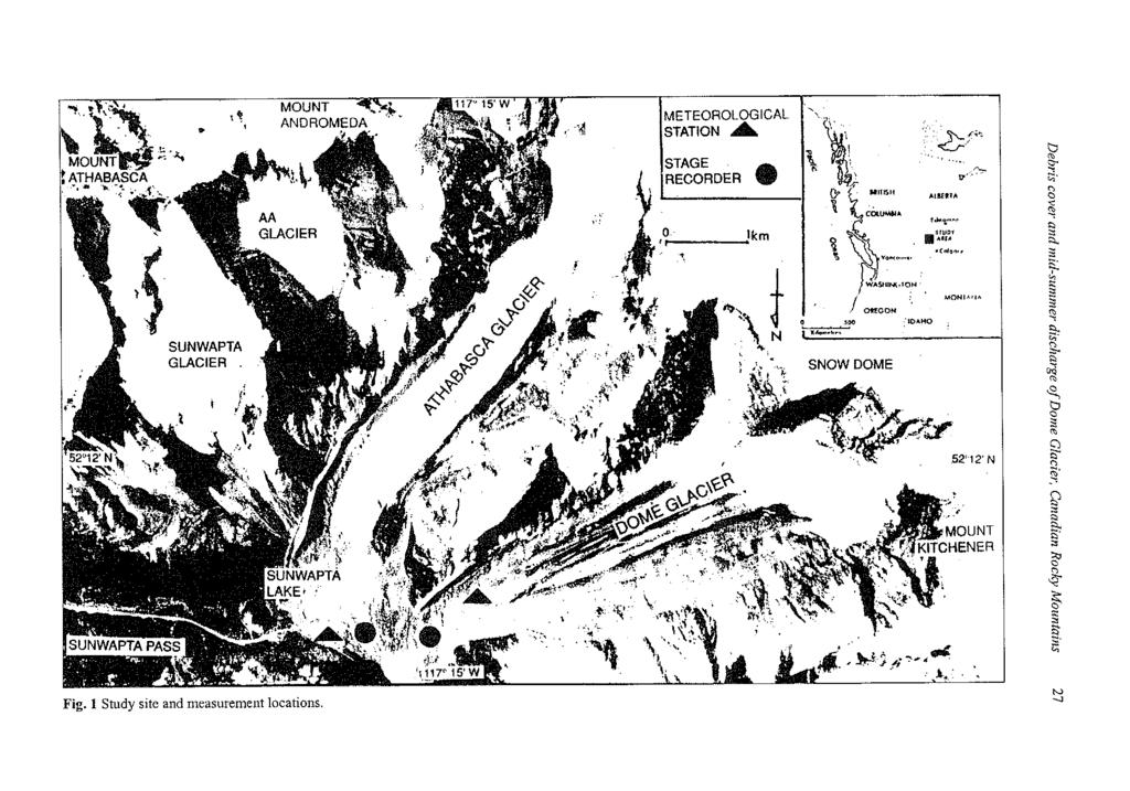
1 Debris-Covered Glaciers (Proceedings of a workshop held at Seattle, Washington, USA, September 2000). IAHS Publ. no. 264, The influence of a debris cover on the midsummer discharge of Dome Glacier, Canadian Rocky Mountains LEIF ERIC MATTSON Department of Geography, Nipissing University, North Bay, Ontario PIB 8L7, Canada ericm@urupissing.ca Abstract Meltwater discharge patterns of two glacierized mountain basins in the Canadian Rocky Mountains are compared over the same 25-day period in 1994 and The glaciers under study are the Dome and Athabasca; both situated in the Columbia Icefield. The two glaciers lie adjacent to one another and are similar in size, orientation, and range in elevation. They differ however, in their surficial characteristics. While the ablation zone of the Athabasca Glacier is mostly debris free, the ablation zone of the Dome Glacier displays an extensive debris cover. It is postulated that this debris cover significantly influences the diurnal discharge patterns of the Dome Glacier's meltwater stream producing different discharge patterns to those observed in the Athabasca Glacier meltwater stream. Results indicate that the debris cover on the Dome Glacier acts as a regulator of streamflow producing annual variances of volumetric discharge of only 1.0% between 1994 and 1995 as compared with 24% for the debris-free Athabasca Glacier. INTRODUCTION It has long been known that significant portions of the world's glaciers carry either a partial or complete debris cover that masks their ablation zones. It is hypothesized that this debris cover significantly influences the discharge characteristics of the meltwater streams emerging from these glaciers through the alteration of surficial energy fluxes. The purpose of this paper is to test this hypothesis by comparing and contrasting the meltwater discharge characteristics of a debris-free glacier and a debris-covered glacier over two contrasting field seasons. REVIEW During the summer of 1989, a 14% difference in meltwater discharge between the Dome and Athabasca Glaciers was measured (in favour of the Athabasca), despite their similarities in size (Mattson, 1990). It was postulated that this difference could possibly be attributed to the debris on the Dome Glacier. Mattson et al. (1993) illustrated that a debris cover can significantly influence the surficial ablation process where, after a threshold thickness of approximately 0.02 m, ablation rates decreased in comparison to "clean" glacier surfaces. They found that the greatest mean ablation rate occurred beneath a debris cover of about 0.01 m. Those areas with less than 0.01 m of debris exhibited relatively lower ablation rates. Similar results had been obtained for

2 26 LeifEric Mattson other debris-covered glaciers through out the world, (e.g. 0strem, 1959; Loomis, 1970; Nakawo & Takahashi, 1982; Khan, 1989). This hyperbolic relationship occurs because a thin layer of debris, rather than insulating the underlying ice, decreases albedo, thereby increasing absorbed shortwave radiation which in a thin debris cover is transmitted to the ice interface contributing to rapid ablation (Mattson & Gardner, 1989). The thermal properties of thick debris covers (>0.03 m) are of critical importance in determining the rate of heat transfer to the debris/ice interface. Mattson & Gardner (1989) found a three-fold increase in the percentage of absorbed surface energy reaching the debris/ice interface of the Rakhiot Glacier when the debris cover was moistened by rainfall. This occurs because of an increase in thermal conductivity. With the continuous fluctuation of the temperature gradient within the debris profile resulting from the variability of the net rate of heat exchange at the surface, the phase and condition of water located within the profile will alter. As a result, the debris cover will not display a continuous conductivity but rather, a series of conductivity's depending on the moisture conditions (Mattson, 1986). STUDY SITES The two basins chosen for this study are the Athabasca (52 11'N 'W) and the Dome (52 12'N 'W), both of which are located in the Columbia Icefield (Fig. 1). These adjacent basins contain the streams that form the headwaters of the Sunwapta River which, in turn, flows via the Athabasca, Slave, and Mackenzie Rivers to the Arctic Ocean. The factors considered in the selection of the basins relate to the degree of similarity between them as well as the relatively easy access to the sites. The Athabasca basin displays a general northeast orientation. It covers an area of roughly 28 km 2. Of this area about 65% or 18 km 2 is covered by glacial ice. There are four glaciers situated within this basin, three of which are relatively small cirque glaciers: the Sunwapta, the AA, and the Andromeda. In total these three glaciers cover an area of 3.7 km 2. The Athabasca Glacier accounts for the remaining 14.3 km 2 of ice cover. The drainage divide for the Athabasca basin is defined by a series of peaks and connecting ridges that encompass it. Along the southeast perimeter Mount Athabasca (3491 m) and Mount Andromeda (3445 m) form the divide. The southern perimeter of the basin is difficult to define because it is located in the greater Icefield. Mount Snow Dome (3456 m) and Little Dome (2750 m) define the northwest perimeter. The mouth of the basin is located along its northeast end. The Sunwapta River emerges from the toe of the glacier and it is from this stream that discharge measurements were derived. The Dome basin also displays a general northeast orientation. In total, the basin covers an area of about 15 km 2 and of this about 68% or 10 km 2 is ice. There is a single cirque glacier associated with the Dome basin; it is situated on the divide between the two basins. This small glacier, known as the Saddle Dome, covers an area of 0.25 km 2 and is thought to contribute an insignificant amount of meltwater to the basin due to its small size and high elevation. The Dome Glacier accounts for the remaining 9.75 km 2 of ice cover.
3
 marks the northwestern perimeter.")
4 28 LeifEric Mattson The drainage divide for the Dome basin is also defined by a series of peaks and the ridges. Little Dome marks the southeast perimeter, Mount Snow Dome marks the southern perimeter, and Mount Kitchener (3490 m) marks the northwestern perimeter. The mouth of the basin is located at the northeast end. There is a single meltwater channel, the Dome River, which flows out of the basin and into the Sunwapta River, 1.5 km below the terminus of the Dome Glacier. The Dome and Athabasca basins are composed predominantly of sedimentary rock from the Palaeozoic era. These rocks have been disturbed and contorted by folding and faulting in response to tectonic activity. The lithologies present are mainly fine-grained mudstone, limestone and dolomite. Green conglomerate, quartzite and shale are also present. It is unknown if either basin is watertight with respect to the subsurface exiting of groundwater. A list of the morphometric, morphologic and dynamic characteristics of the Dome and Athabasca Glaciers is presented in Table 1. It indicates that the two glaciers are very similar with regards to all physical attributes. The extensive debris cover is the most evident characteristic that differentiates the Dome from the Athabasca Glacier. Debris thickness were interpolated for the surface from a series of spot depth measurements, including manually dug pits where thickness could not be visually estimated. The debris cover extends completely over the glacier surface from the terminus to a distance of 625 m upglacier. From this point on, to a distance of 3.5 km from the terminus, the debris cover dominates the surface of the glacier with only a thin strip of "clean" ice extending up the centre. There is a general tendency for the debris-cover thickness to decrease from the lateral margins to the centre axis of the glacier. The debris is up to 0.5 m thick along the margins of the glacier. Summer field observations since 1984 indicate that debris sources include: snow and ice avalanches off the north face of Mount Snow Dome (as many as 21 per day), high-frequency lowmagnitude rockfalls from adjacent slopes (as many as 100 per day), and the emergence of englacial debris derived from subglacial erosion. Table 1 Morphologic, morphometric, and dynamic characteristics of the Dome and Athabasca Glaciers. Physical attributes Dome Athabasca Glacier length (m) Maximum elevation (m a.s.l.) Terminus elevation (m a.s.l.) Altitudinal range (m) Average gradient 1:6 1:4 Firn line elevation (m a.s.l.) Area of accumulation zone (km 2 ) Area of ablation zone (km 2 ) Ice thickness at base of icefall (m)* Velocity at base of icefall (m year"')t Year of maximum Holocene extent J Rate of retreat ( ) (m year"') Rate of retreat ( ) (myear" 1 ) * Cited in Kite & Reid (1977). f Cited in Paterson & Savage (1963). X Cited in Luckman (1988). Cited in Deaton (1975).
 and")
5 Debris cover and mid-summer discharge of Dome Glacier, Canadian Rocky Mountains 29 DATA COLLECTION Meltwater discharge was monitored for both years from 11 July to 9 August for the Dome Glacier basin. Discharge data derived from this basin include both instantaneous stream discharge, calculated on the basis of measurements of water velocity (using an Ott model current meter) and cross-sectional area and continuous stage records which have been translated to hourly readings of discharge through a rating curve. The rationale for employing this technique, though not recommended for streams displaying unstable hydraulic conditions, was to maintain consistency with the data set collected by the Federal Government for the Sunwapta River. Discharge measurements were taken over a 12-h period (06:00-18:00 h) at 15-min intervals resulting in 48 readings. Regression analysis between stage and discharge revealed an r 2 value of 0.98 and 0.97 for 1994 and 1995, respectively. Discharge data for the Sunwapta River (Athabasca basin) were obtained from Inland Waters of Environment Canada and are stated to contain less than 5.0% error. Figure 1 indicates the location of the Sunwapta and Dome River stage recorders. Meteorological measurements were collected from a standard meteorological station situated near the confluence of the two basins at an elevation of 1950 m (Fig. 1). Specific variables measured included relative humidity, air and surface temperature, precipitation as well as incident solar and net radiation. Readings were recorded at 5-min intervals through the employment of a Squirrel data logger. These values were then averaged over hourly periods resulting in a record of over 5000 readings per field season. Additional meteorological information was obtained from the Columbia Icefield Information Centre operated by Parks Canada. OBSERVATIONS Because of the high contrast in meteorological conditions, the 1994 and 1995 field seasons turned out to be ideal for this study. The 1994 field season was predominantly warm, with clear skies and air temperatures averaging 12.1 C. The maximum and minimum temperatures recorded were 22.5 C and 2.5 C, respectively. Cloud cover, measured three times a day, ranged from 0 to 10 tenths but averaged 3 and rain only occurred on 7 days resulting in a total of 30.5 mm. Conversely, the 1995 field season was characterized by cool, wet conditions. The mean air temperature averaged 9.5 C, a difference of 2.6 C from the previous year. The maximum and minimum temperatures recorded were 18.8 C and 1.3 C, respectively. Cloud cover ranged from 0 to 10 tenths but averaged 9 and rain occurred on all but 2 days resulting in a total of 60.9 mm. The 1994 and 1995 hydrographs of the Sunwapta and Dome Rivers (Figs 2 and 3, respectively) were characterized by a series of oscillating waves typical of most proglacial streams described in the literature. This basic pattern consists of a diurnal cycle of rising and falling limbs superimposed over a more consistent baseflow. The baseflow is derived primarily from a combination of groundwater and subglacial melt however the percent contribution of each is unknown to the author. The superimposed daily pattern is primarily controlled by the individual components of the diurnal energy
6 30 LeifEric Mattson Athabasca Glacier, 1994 / 95 Discharge a\_ r y t,,,,,,,,,,,,..,,,.,,...i Q1994 % X X X X X XXXXXXXXXXXXXX X XXw Fig. 2 Discharge for the Sunwapta River from 11 July to 5 August 1994 and Dome Glacier, 1994 / 95 Discharge 15-! o 10- Fig. 3 Discharge records for the Dome River from 11 July to 5 August 1994 and exchange that exists between the atmospheric boundary layer and the surface of the glacier. The energy exchange includes the turbulent fluxes of latent and sensible heat, net radiation, conductive heat flux and precipitation heat transfer. This energy exchange controls the amount of surficial ablation which, in turn, determines the amount of meltwater production from the surface of the glacier. It is evident that the quantities of water released by both basins are of the same order of magnitude. However, a significant difference does exist. The mean discharge for the Sunwapta River during the 1994 field season was 7.79 m 3 s" 1 resulting in an average runoff of 0.28 m 3 s" 1 km" 2 for the Athabasca basin. The total volume of

7 Debris cover and mid-summer discharge of Dome Glacier, Canadian Rocky Mountains 31 meltwater produced over the sampling period was x 10 6 m 3. The mean seasonal discharge for the Dome River for the same period was only 4.40 m 3 s" 1 resulting in an average runoff of 0.29 m 3 s" 1 km" 2 for the Dome basin. The total volume of meltwater produced over the sampling period was 9.45 x 10 6 m 3 ; 7.28 x 10 6 m 3 less than that of the Athabasca basin. The 1995 discharge pattern of the Dome River was similar to that experienced for the same sampling period in 1994 with the exception of an obvious increase in the amount of "noise" experienced. An examination of the meteorological record reveals that these minor spikes in the discharge record correspond with rainfall events. A lag of approximately 1 h exists between the initiation of rainfall and an abrupt increase in discharge indicating the time in which it takes for water to travel through the glacial system. The reason for the absence of the same phenomenon on the discharge record for the Athabasca basin is due to the fact that Sunwapta Lake, a small proglacial lake (Fig. 1) lies between the glacier and the stage recorder. The lake acts as a buffer to these events which results in a much smoother hydrograph. Discharges greater than the 1994 maximum were also due to rainfall events. The mean discharge of the Dome basin in 1995 was approximately 4.41 m 3 s" 1 resulting in an average runoff of 0.29 m 3 s" 1 km" 2. The total volume of water produced from the basin was 9.48 x 10 6 m 3. The 1995 mean seasonal discharge for the Sunwapta River was 5.84 m 3 s" 1 resulting in an average runoff of 0.21 m 3 s" 1 km" 2. The total volume of water produced from the basin was x 10 6 m 3 ;3.08 x 10 6 m 3 more than for the Dome over the same period. In comparing the basins on an individual basis over the two years one can see that large differences exist. Volumetric discharge derived from the Dome Glacier between the 1994 and 1995 field seasons varied by x 10 6 m 3 which translates to a difference of less than 1.0%. On the other hand, the volumetric discharge derived from the Athabasca Glacier for the same period differed by 4.18 x 10 6 m 3 or 24%. DISCUSSION Lower volumes of meltwater derived from the Dome basin, when compared to the Athabasca basin, can be easily explained by the fact that it is smaller in size and contains less ice cover. More specifically, the Dome basin is smaller by 13 km 2 and contains 8 km 2 less ice cover. When the areas of each basin are taken into consideration, and specific discharge or runoff is calculated for each, the two almost equate. This is not surprising considering the fact that the basins lie adjacent to each other and experience the same meteorological conditions. What is of greater interest is the large variation in discharge for the Athabasca basin between the two field seasons compared to that for the Dome basin which varied little. One possible explanation for this could be due to the absence or presence of a debris cover. In the case of the Athabasca Glacier, which displays primarily a debrisfree surface, all of the energy being absorbed through the latent, sensible, and radiative heat fluxes is used directly to melt the exposed ice. No energy is lost through the conductive heat flux into the glacier due to the fact that the ice is at its pressure melting point. During the 1994 field season, which was characterized by warm, clear sky conditions, ample energy was available to promote ablation which, in turn, led to the

8 32 LeifEric Mattson production of large quantities of meltwater. However, during the 1995 field season, which was characterized by cool, overcast conditions, less energy was available to promote ablation leading to significantly less runoff. In the case of a relatively thick debris cover, such as that found on the Dome Glacier, the situation is quite different. During the 1994 field season the debris cover became very dry and much of the energy being absorbed at the debris surface could not reach the underlying ice. A large portion of the energy was expended in increasing the surface and subsurface temperature of the debris cover. This energy was then lost back to the atmospheric boundary layer through the emission of longwave radiation and sensible heat. Only a fraction of the absorbed energy could be transferred to the debris/ice interface because of the low conductivity associated with the dry debris. The wet conditions associated with the 1995 field season exerted a tremendous influence on the physical properties of the debris cover by increasing its thermal conductivity. Although less energy was being absorbed at the atmosphere/debris interface a greater proportion of it was being transferred to the underlying ice to promote ablation. The two-fold increase in precipitation would also add to the volume of water leaving the Dome and Athabasca basins over the 1995 field season but would not account for the differences in variation between the two. CONCLUSIONS This study indicates, by way of presenting volumetric discharge data, that a debris cover may play a significant role in glacier hydrology. Results suggest that the debris cover on the Dome Glacier acts as a regulator of streamflow producing annual variances of volumetric discharge of only 1.0% between 1994 and 1995 as compared with 24% for the debris-free Athabasca Glacier. This most likely occurs because of the changes of moisture content within the debris cover between field seasons. When atmospheric conditions are warm and dry, and ample energy is available for melt, the debris cover retards the transfer of energy to the ice because of its low thermal conductivity. When atmospheric conditions are cool and wet, and little energy is available for melt, the debris cover promotes the transfer of energy to the ice because of its increased thermal conductivity. This implies that a debris-covered glacier may not be as sensitive to changes in climate as would be a debris-free glacier, however, further research is required in order to substantiate this claim. REFERENCES Deaton, G. H. (1975) Glaciers of the Canadian Rocky Mountains. In: Mountain Glaciers of the Northern Hemisphere by W. O. Field). CRREL, Bangor, Maine, USA. Khan, M. (1989) Ablation on Barpu Glacier, Karakoram Himalaya, Pakistan: a study of melt processes on a faceted, debris-covered ice surface. Unpublished Master's Thesis, Wilfrid Laurier University, Waterloo, Canada. Kite, G. W. & Reid, L. A. (1977) Volumetric change of the Athabasca Glacier over the last 100 years. In: J. Hydrol. 32, Loomis, S. R. (1970) Morphology and Structure of an Ice-cored Medial Moraine, Kaskawulsh Glacier, Yukon. In: Studies of Morphology and Stream Action on Ablating Ice (ed. by S. R. Loomis, J. Dozier & K. J. Ewing), Res. Paper no. 57, Arctic Inst. North America, Calgary, Ontario, Canada. Luckman, B. H. (1988) Dating the moraines and recession of Athabasca and Dome Glacier, Alberta, Canada. Arctic Alpine Res. 20(1), (ed.
 The formation and degradation of recently developed ice-cored lateral moraines, Boundary Glacier, Canadian Rocky Mountains. Unpublished Master's Thesis, University of Waterloo, Canada.")
9 Debris cover and mid-summer discharge of Dome Glacier, Canadian Rocky Mountains 33 Mattson, L. E. (1986) The formation and degradation of recently developed ice-cored lateral moraines, Boundary Glacier, Canadian Rocky Mountains. Unpublished Master's Thesis, University of Waterloo, Canada. Mattson, L. E. (1990) The role of debris covers on glacial meltwater discharge, Canadian Rocky Mountains. In: 47th Eastern Snow Conference Annual Proceedings (ed. by M. Ferrick) (Bangor, Maine), CRREL Special Report 90-44, Bangor, Maine, USA. Mattson, L. E. & Gardner, J. S. (1989) Energy exchanges and ablation rates on the debris covered Rakhiot Glacier, Pakistan. Z. Glelscherk. und Glazialgeol. 25(1), Mattson, L. E., Gardner, J. S. & Young, G. J. (1993) Ablation on debris covered glaciers: an example from the Rakhiot Glacier, Punjab, Himalaya. In: Snow and Glacier Hydrology (ed. by G. J. Young) (Proc. Kathmandu Symp., November 1992), IAHS Publ. no Nakawo, M. & Takahashi, S. (1982) A simplified model for estimating glacier ablation under a debris layer. In: Hydrological Aspects of Alpine and High-Mountain Areas (ed. by J. W. Glen) (Proc. Exeter Symp., July 1982), IAHS Publ. no strem, G. (1959) Ice melting under a thin layer of moraine, and the existence of ice cores in moraine ridges. Geogr. Ann._ 41, Paterson, N. S. B. & Savage, J. C. (1963) Geometry and movement of the Athabasca Glacier. J. Geophys. Res. 68,
Revised Draft: May 8, 2000
 Revised Draft: May 8, 2000 Accepted for publication by the International Association of Hydrological Sciences. Paper will be presented at the Debris-Covered Glaciers Workshop in September 2000 at the University
NORTH CASCADE SLACIER CLIMATE PROJECT Director: Dr. Mauri S. Pelto Department of Environmental Science Nichols College, Dudley MA 01571
 NORTH CASCADE SLACIER CLIMATE PROJECT Director: Dr. Mauri S. Pelto Department of Environmental Science Nichols College, Dudley MA 01571 INTRODUCTION The North Cascade Glacier-Climate Project was founded
GLACIER STUDIES OF THE McCALL GLACIER, ALASKA
 GLACIER STUDIES OF THE McCALL GLACIER, ALASKA T John E. Sater* HE McCall Glacier is a long thin body of ice shaped roughly like a crescent. Its overall length is approximately 8 km. and its average width
Chapter 7 Snow and ice
 Chapter 7 Snow and ice Throughout the solar system there are different types of large ice bodies, not only water ice but also ice made up of ammonia, carbon dioxide and other substances that are gases
Seasonal variation of ice melting on varying layers of debris of Lirung Glacier, Langtang Valley, Nepal
 Remote Sensing and GIS for Hydrology and Water Resources (IAHS Publ. 368, 2015) (Proceedings RSHS14 and ICGRHWE14, Guangzhou, China, August 2014). 21 Seasonal variation of ice melting on varying layers
2. (1pt) From an aircraft, how can you tell the difference between a snowfield and a snow-covered glacier?
 From an aircraft, how can you tell the difference between a snowfield and a snow-covered glacier?") 1 GLACIERS 1. (2pts) Define a glacier: 2. (1pt) From an aircraft, how can you tell the difference between a snowfield and a snow-covered glacier? 3. (2pts) What is the relative size of Antarctica, Greenland,
1 GLACIERS 1. (2pts) Define a glacier: 2. (1pt) From an aircraft, how can you tell the difference between a snowfield and a snow-covered glacier? 3. (2pts) What is the relative size of Antarctica, Greenland,
A high resolution glacier model with debris effects in Bhutan Himalaya. Orie SASAKI Kanae Laboratory 2018/02/08 (Thu)
") A high resolution glacier model with debris effects in Bhutan Himalaya Orie SASAKI Kanae Laboratory 2018/02/08 (Thu) Research flow Multiple climate data at high elevations Precipitation, air temperature
A high resolution glacier model with debris effects in Bhutan Himalaya Orie SASAKI Kanae Laboratory 2018/02/08 (Thu) Research flow Multiple climate data at high elevations Precipitation, air temperature
THE DISEQUILBRIUM OF NORTH CASCADE, WASHINGTON GLACIERS
 THE DISEQUILBRIUM OF NORTH CASCADE, WASHINGTON GLACIERS CIRMOUNT 2006, Mount Hood, OR Mauri S. Pelto, North Cascade Glacier Climate Project, Nichols College Dudley, MA 01571 peltoms@nichols.edu NORTH CASCADE
Snow, Glacier and GLOF
 Snow, Glacier and GLOF & Report on Demonstration River Basin Activities Upper Indus Basin The 5th International Coordination Group (ICG) Meeting GEOSS Asian Water Cycle Initiative (AWCI) Tokyo, Japan,
Glaciological and Historical Analyses at the Boundary Glacier, Canadian Rocky Mountains
 Western Geography, 10/11(2000/01), pp. 30 42 Western Division, Canadian Association of Geographers Glaciological and Historical Analyses at the Boundary Glacier, Canadian Rocky Mountains N.K. Jones Professor
The Role of Glaciers in the Hydrologic Regime of the Nepal Himalaya. Donald Alford Richard Armstrong NSIDC Adina Racoviteanu NSIDC
 The Role of Glaciers in the Hydrologic Regime of the Nepal Himalaya Donald Alford Richard Armstrong NSIDC Adina Racoviteanu NSIDC Outline of the talk Study area and data bases Area altitude distributed
Glaciers and Glaciation Earth - Chapter 18 Stan Hatfield Southwestern Illinois College
 Glaciers and Glaciation Earth - Chapter 18 Stan Hatfield Southwestern Illinois College Glaciers Glaciers are parts of two basic cycles: 1. Hydrologic cycle 2. Rock cycle A glacier is a thick mass of ice
Glaciers Earth 9th Edition Chapter 18 Mass wasting: summary in haiku form Glaciers Glaciers Glaciers Glaciers Formation of glacial ice
 1 2 3 4 5 6 7 8 9 10 11 12 13 14 15 Earth 9 th Edition Chapter 18 Mass wasting: summary in haiku form Ten thousand years thence big glaciers began to melt - called "global warming." are parts of two basic
Rapid decrease of mass balance observed in the Xiao (Lesser) Dongkemadi Glacier, in the central Tibetan Plateau
 Dongkemadi Glacier, in the central Tibetan Plateau") HYDROLOGICAL PROCESSES Hydrol. Process. 22, 2953 2958 (2008) Published online 8 October 2007 in Wiley InterScience (www.interscience.wiley.com).6865 Rapid decrease of mass balance observed in the Xiao
HYDROLOGICAL PROCESSES Hydrol. Process. 22, 2953 2958 (2008) Published online 8 October 2007 in Wiley InterScience (www.interscience.wiley.com).6865 Rapid decrease of mass balance observed in the Xiao
New measurements techniques
 2 nd Asia CryoNetWorkshop New measurements techniques Xiao Cunde (SKLCS/CAS and CAMS/CMA) Feb.5, 2016, Salekhard, Russia Outline Definition of New Some relative newly-used techniques in China -- Eddy covariance
Nepal Hirnalaya and Tibetan Plateau: a case study of air
 Annals of Glaciology 16 1992 International Glaciological Society Predictions of changes of glacier Inass balance in the Nepal Hirnalaya and Tibetan Plateau: a case study of air teinperature increase for
Typical avalanche problems
 Typical avalanche problems The European Avalanche Warning Services (EAWS) describes five typical avalanche problems or situations as they occur in avalanche terrain. The Utah Avalanche Center (UAC) has
Simulation of runoff processes of a continental mountain glacier in the Tian Shan, China
 Biogeochemistry of Seasonally Snow-Covered Catchments (Proceedings of a Boulder Symposium, July 1995). IAHS Publ. no. 228, 1995. 455 Simulation of runoff processes of a continental mountain glacier in
Tidewater Glaciers: McCarthy 2018 Notes
 Tidewater Glaciers: McCarthy 2018 Notes Martin Truffer, University of Alaska Fairbanks June 1, 2018 What makes water terminating glaciers special? In a normal glacier surface mass balance is always close
MAURI PELTO, Nichols College, Dudley, MA
 MAURI PELTO, Nichols College, Dudley, MA 01571(mspelto@nichols.edu) Advice I am looking for Better schemes for utilizing atmospheric circulation indices to provide a better forecast for glacier mass balance?
Glacial lakes as sentinels of climate change in Central Himalaya, Nepal
 Glacial lakes as sentinels of climate change in Central Himalaya, Nepal Sudeep Thakuri 1,2,3, Franco Salerno 1,3, Claudio Smiraglia 2,3, Carlo D Agata 2,3, Gaetano Viviano 1,3, Emanuela C. Manfredi 1,3,
PHYSICAL GEOGRAPHY GEOGRAPHY EARTH SYSTEMS COASTAL SYSTEMS FLUVIAL SYSTEMS
 PHYSICAL GEOGRAPHY EARTH SYSTEMS FLUVIAL SYSTEMS COASTAL SYSTEMS PHYSICAL GEOGRAPHY CORRIES / CIRQUES A Corrie or Cirque is the armchair shaped hollow that was the birthplace of a glacier. It has steep,
Albedo of Glacier AX 010 during the Summer Season in Shorong Himal, East Nepal*
 48 Albedo of Glacier AX 010 in Shorong Himal Albedo of Glacier AX 010 during the Summer Season in Shorong Himal, East Nepal* Tetsuo Ohata,** Koichi Ikegami** and Keiji Higuchi** Abstract Variations of
Glaciology. Water. Glacier. Moraine. Types of glacier-dammed lakes. Mechanics of jökulhlaup
 A Jökulhlaup Jökulhlaup. Catastrophic events where large amounts of water are suddenly discharged. Jökulhlaup s are a sudden and rapid draining of a glacier dammed lake or of water impounded within a glacier.
Biotic Acceleration of Glacier Melting in Yala Glacier 9 Langtang Region, Nepal Himalaya
 Snow and Glacier Hydrology (Proceedings of the Kathmandu Symposium, November 992). IAHS Publ. no. 28,993. 309 Biotic Acceleration of Glacier Melting in Yala Glacier 9 Langtang Region, Nepal Himalaya SHIRO
GEOSPATIAL ANALYSIS OF GLACIAL HAZARDS PRONE AREAS OF SHIGAR AND SHAYOK BASINS OF PAKISTAN. By Syed Naseem Abbas Gilany
 GEOSPATIAL ANALYSIS OF GLACIAL HAZARDS PRONE AREAS OF SHIGAR AND SHAYOK BASINS OF PAKISTAN By Syed Naseem Abbas Gilany PRESENTATION OUTLINE Introduction Problem Statement / Rationale Objectives Material
THE NET VOLUMETRIC LOSS OF GLACIER COVER WITHIN THE BOW VALLEY ABOVE BANFF, /
 THE NET VOLUMETRIC LOSS OF GLACIER COVER WITHIN THE BOW VALLEY ABOVE BANFF, 1951-1993 1/ ABSTRACT CHRIS HOPKINSON 2/ Three methods have been used to explore the volumetric change of glaciers in the Bow
Twentieth century surface elevation change of the Miage Glacier, Italian Alps
 Debris-Covered Glaciers (Proceedings of a workshop held at Seattle, Washington, USA, September 2000). IAHS Publ. no. 264, 2000. 219 Twentieth century surface elevation change of the Miage Glacier, Italian
Characteristics of Khumbu Glacier, Nepal Himalaya: recent change in the debris-covered area
 Annals of Glaciology 28 1999 # International Glaciological Society Characteristics of Khumbu Glacier, Nepal Himalaya: recent change in the debris-covered area M. Nakawo, H.Yabuki, A. Sakai Institute for
Chapter 16 Glaciers and Glaciations
 Chapter 16 Glaciers and Glaciations Name: Page 419-454 (2nd Ed.) ; Page 406-439 (1st Ed.) Part A: Anticipation Guide: Please read through these statements before reading and mark them as true or false.
Mapping the Snout. Subjects. Skills. Materials
 Subjects Mapping the Snout science math physical education Skills measuring cooperative action inferring map reading data interpretation questioning Materials - rulers - Mapping the Snout outline map and
READING QUESTIONS: Glaciers GEOL /WI 60 pts. a. Alpine Ice from larger ice masses flowing through a valley to the ocean
 READING QUESTIONS: Glaciers GEOL 131 18/WI 60 pts NAME DUE: Tuesday, March 13 Glaciers: A Part of Two Basic Cycles (p. 192-195) 1. Match each type of glacier to its description: (2 pts) a. Alpine Ice from
Seasonal variations of water temperature and discharge in rivers draining ice free and partially glacierised Alpine basins
 Seasonal variations of water temperature and discharge in rivers draining ice free and partially glacierised Alpine basins Collins, DN Title Authors Type URL Published Date 2009 Seasonal variations of
Community resources management implications of HKH hydrological response to climate variability
 Community resources management implications of HKH hydrological response to climate variability -- presented by N. Forsythe on behalf of: H.J. Fowler, C.G. Kilsby, S. Blenkinsop, G.M. O Donnell (Newcastle
TEACHER PAGE Trial Version
 TEACHER PAGE Trial Version * After completion of the lesson, please take a moment to fill out the feedback form on our web site (https://www.cresis.ku.edu/education/k-12/online-data-portal)* Lesson Title:
Glaciers. Reading Practice
 Reading Practice A Glaciers Besides the earth s oceans, glacier ice is the largest source of water on earth. A glacier is a massive stream or sheet of ice that moves underneath itself under the influence
Recent Changes in Glacier Tongues in the Langtang Khola Basin, Nepal, Determined by Terrestrial Photogrammetry
 Snow and Glacier Hydrology (Proceedings of the Kathmandu Symposium, November 1992). IAHSPubl. no. 218,1993. 95 Recent Changes in Glacier Tongues in the Langtang Khola Basin, Nepal, Determined by Terrestrial
Glaciers. Clicker Question. Glaciers and Glaciation. How familiar are you with glaciers? West Greenland. Types of Glaciers.
 Chapter 21 Glaciers A glacier is a large, permanent (nonseasonal) mass of ice that is formed on land and moves under the force of gravity. Glaciers may form anywhere that snow accumulation exceeds seasonal
GLOFs from moraine-dammed lakes: their causes and mechanisms V. Vilímek, A. Emmer
 GLOFs from moraine-dammed lakes: their causes and mechanisms V. Vilímek, A. Emmer Department of Physical Geography and Geoecology, Faculty of Science, Charles University, Prague, Czech Republic vilimek@natur.cuni.cz
READING QUESTIONS: Chapter 7, Glaciers GEOL 131 Fall pts. a. Alpine Ice from larger ice masses flowing through a valley to the ocean
 READING QUESTIONS: Chapter 7, Glaciers GEOL 131 Fall 2018 63 pts NAME DUE: Tuesday, October 23 Glaciers: A Part of Two Basic Cycles (p. 192-195) 1. Match each type of glacier to its description: (2 pts)
WATER, ICE, AND METEOROLOGICAL MEASUREMENTS AT SOUTH CASCADE GLACIER, WASHINGTON, BALANCE YEARS
 WATER, ICE, AND METEOROLOGICAL MEASUREMENTS AT SOUTH CASCADE GLACIER, WASHINGTON, 2-1 BALANCE YEARS U.S. GEOLOGICAL SURVEY Water-Resources Investigations Report 2-4165 South Cascade Glacier, looking approximately
Geography 120, Instructor: Chaddock In Class 13: Glaciers and Icecaps Name: Fill in the correct terms for these descriptions: Ablation zone: n zne:
 Geography 120, Instructor: Chaddock In Class 13: Glaciers and Icecaps Name: Fill in the correct terms for these descriptions: Ablation zone: The area of a glacier where mass is lost through melting or
Shrubs and alpine meadows represent the only vegetation cover.
 Saldur river General description The study area is the upper Saldur basin (Eastern Italian Alps), whose elevations range from 2150 m a.s.l. (location of the main monitoring site, LSG) and 3738 m a.s.l.
Field Report Snow and Ice Processes AGF212
 Field Report 2013 Snow and Ice Processes AGF212 (picture) Names... Contents 1 Mass Balance and Positive degree day approach on Spitzbergen Glaciers 1 1.1 Introduction............................................
Q: What is a period of time whereby the average global temperature has decreased? Q: What is a glacier?
 Q: What is a glacier? A: A large sheet of ice which lasts all year round. Q: What is a period of time whereby the average global temperature has decreased? A: A glacial. Q: What is an interglacial? Q:
EXPERIENCES WITH THE NEW HYDRO-METEOROLOGICAL
 EXPERIENCES WITH THE NEW HYDRO-METEOROLOGICAL STATION VERNAGTBACH LUDWIG N. BRAUN, HEIDI ESCHER-VETTER, ERICH HEUCKE, MATTHIAS SIEBERS AND MARKUS WEBER Commission for Glaciology, Bavarian Academy of Sciences
I. Types of Glaciers 11/22/2011. I. Types of Glaciers. Glaciers and Glaciation. Chapter 11 Temp. B. Types of glaciers
 Why should I care about glaciers? Look closely at this graph to understand why we should care? and Glaciation Chapter 11 Temp I. Types of A. Glacier a thick mass of ice that originates on land from the
- MASS and ENERGY BUDGETS - IN THE CRYOSPHERE
 PRINCIPLES OF GLACIOLOGY ESS 431 - MASS and ENERGY BUDGETS - IN THE CRYOSPHERE OCTOBER 17, 2006 Steve Warren sgw@atmos.washington.edu Sources Paterson, W.S.B. 1994. The Physics of Glaciers. 3 rd ed. Pergamon.
Climate Change and State of Himalayan Glaciers: Issues, Challenges and Facts
 Climate Change and State of Himalayan Glaciers: Issues, Challenges and Facts D.P. Dobhal dpdobhal@wihg.res.in Wadia Institute of Himalayan Geology Dehra Dun Major Issues Are the Himalayan glaciers receding
Geomorphology. Glacial Flow and Reconstruction
 Geomorphology Glacial Flow and Reconstruction We will use simple mathematical models to understand ice dynamics, recreate a profile of the Laurentide ice sheet, and determine the climate change of the
Using LiDAR to study alpine watersheds. Chris Hopkinson, Mike Demuth, Laura Chasmer, Scott Munro, Masaki Hayashi, Karen Miller, Derek Peddle
 Using LiDAR to study alpine watersheds Chris Hopkinson, Mike Demuth, Laura Chasmer, Scott Munro, Masaki Hayashi, Karen Miller, Derek Peddle Light Detection And Ranging r t LASER pulse emitted and reflection
glacier Little Ice Age continental glacier valley glacier ice cap glaciation firn glacial ice plastic flow basal slip Chapter 14
 Little Ice Age glacier valley glacier continental glacier ice cap glaciation firn glacial ice plastic flow basal slip glacial budget zone of accumulation zone of wastage glacial surge abrasion glacial
The SHARE contribution to the knowledge of the HKKH glaciers, the largest ice masses of our planet outside the polar regions
 The SHARE contribution to the knowledge of the HKKH glaciers, the largest ice masses of our planet outside the polar regions Claudio Smiraglia 1 with the collaboration of Guglielmina Diolaiuti 1 Christoph
Fifty-Year Record of Glacier Change Reveals Shifting Climate in the Pacific Northwest and Alaska, USA
 Fact Sheet 2009 3046 >> Pubs Warehouse > FS 2009 3046 USGS Home Contact USGS Search USGS Fifty-Year Record of Glacier Change Reveals Shifting Climate in the Pacific Northwest and Alaska, USA Fifty years
The Potentially Dangerous Glacial Lakes
 Chapter 11 The Potentially Dangerous Glacial Lakes On the basis of actively retreating glaciers and other criteria, the potentially dangerous glacial lakes were identified using the spatial and attribute
Eastern Snow Conference: 2017 Student Award Recipient
 Eastern Snow Conference: 2017 Student Award Recipient Presentation title: Tracking changes in iceberg calving events and characteristics from Trinity and Wykeham Glaciers, SE Ellesmere, Canada Authors:
Mass balance of a cirque glacier in the U.S. Rocky Mountains
 Mass balance of a cirque glacier in the U.S. Rocky Mountains B. A. REARDON 1, J. T. HARPER 1 and D.B. FAGRE 2 1 Department of Geosciences, University of Montana, 32 Campus Drive #1296,Missoula, MT 59812-1296
Environmental Impact Assessment in Chile, its application in the case of glaciers. Carlos Salazar Hydro21 Consultores Ltda.
 Environmental Impact Assessment in Chile, its application in the case of glaciers Carlos Salazar Hydro21 Consultores Ltda. carlos.salazar@hydro21.cl Introduction Changes in the environmental law in Chile
Dating the Asulkan s East Spill Over Zone. Cali Bingham, Kara Piman, Blair Underhill, Martin Demidow, Sam Ward, Derek Heathfield and Ahmed Mumeni
 Dating the Asulkan s East Spill Over Zone Cali Bingham, Kara Piman, Blair Underhill, Martin Demidow, Sam Ward, Derek Heathfield and Ahmed Mumeni Purpose and Objectives Establish approximate dates of terminal
Observation of cryosphere
 Observation of cryosphere By Sagar Ratna Bajracharya (email: sagar.bajracharya@icimod.org) Samjwal Ratna Bajracharya Arun Bhakta Shrestha International Centre for Integrated Mountain Development Kathmandu,
Integration Of Reflectance To Study Glacier Surface Using Landsat 7 ETM+: A Case Study Of The Petermann Glacier In Greenland
 Integration Of Reflectance To Study Glacier Surface Using Landsat 7 ETM+: A Case Study Of The Petermann Glacier In Greenland Félix O. Rivera Santiago Department Of Geology, University Of Puerto Rico, Mayaguez
BLASTING GLACIAL ICE AND SNOW ABSTRACT
 BLASTING GLACIAL ICE AND SNOW HERB BLEUER ABSTRACT This presentation, with the aid of slides, is about methods of blasting large quantities of glacial ice and snow. The project illustrated here involved
Hydrology Input for West Souris River IWMP
 Hydrology Input for West Souris River IWMP Prepared by: Mark Lee Manitoba Water Stewardship 1 1 1 Overall view of: drainage area watershed characteristics gauging stations meteorological stations Runoff
Present health and dynamics of glaciers in the Himalayas and Arctic
 Present health and dynamics of glaciers in the Himalayas and Arctic AL. Ramanathan and Glacilogy Team School of Environmental Sciences, Jawaharlal Nehru University AL. Ramanthan, Parmanand Sharma, Arindan
J. Oerlemans - SIMPLE GLACIER MODELS
 J. Oerlemans - SIMPE GACIER MODES Figure 1. The slope of a glacier determines to a large extent its sensitivity to climate change. 1. A slab of ice on a sloping bed The really simple glacier has a uniform
Warming planet, melting glaciers
 Warming planet, melting glaciers Arun B Shrestha abshrestha@icimod.org International Centre for Integrated Mountain Development Kathmandu, Nepal Asia-Pacific Youth forum on Climate Actions and Mountain
Characteristics and climatic sensitivities of runoff from a cold-type glacier on the Tibetan Plateau
 HYDROLOGICAL PROCESSES Hydrol. Process. 21, 2882 2891 (2007) Published online 7 December 2006 in Wiley InterScience (www.interscience.wiley.com).6505 Characteristics and climatic sensitivities of runoff
Glaciers. Glacier Dynamics. Glaciers and Glaciation. East Greenland. Types of Glaciers. Chapter 16
 Chapter 16 Glaciers A glacier is a large, permanent (nonseasonal) mass of ice that is formed on land and moves under the force of gravity. Glaciers may form anywhere that snow accumulation exceeds seasonal
Glaciers. Valley or Alpine glaciers. Ice sheets. Piedmont - foot of the mountain glaciers. Form in mountainous areas Move downslope in valleys
 Glaciers & Ice Ages Glaciers Valley or Alpine glaciers Form in mountainous areas Move downslope in valleys Ice sheets Move outward from center Continental glaciers - large scale, ice age type. Presently
Active Glacier Protection in Austria - An adaptation strategy for glacier skiing resorts
 in Austria - An adaptation strategy for glacier skiing resorts Presented by Marc Olefs Ice and Climate Group, Institute of Meteorology And Geophysics, University of Innsbruck Centre for Natural Hazard
GEOGRAPHY OF GLACIERS 2
 GEOGRAPHY OF GLACIERS 2 Roger Braithwaite School of Environment and Development 1.069 Arthur Lewis Building University of Manchester, UK Tel: UK+161 275 3653 r.braithwaite@man.ac.uk 09/08/2012 Geography
Lesson 5: Ice in Action
 Everest Education Expedition Curriculum Lesson 5: Ice in Action Created by Montana State University Extended University and Montana NSF EPSCoR http://www.montana.edu/everest Lesson Overview: Explore glaciers
Assessment of glacier water resources based on the Glacier Inventory of China
 104 Annals of Glaciology 50(53) 2009 Assessment of glacier water resources based on the Glacier Inventory of China KANG Ersi, LIU Chaohai, XIE Zichu, LI Xin, SHEN Yongping Cold and Arid Regions Environmental
Glaciers. Chapter 17
 Glaciers Chapter 17 Vocabulary 1. Glacier 2. Snowfield 3. Firn 4. Alpine glacier 5. Continental glacier 6. Basal slip 7. Internal plastic flow 8. Crevasses 9. Glacial grooves 10. Ice shelves 11. Icebergs
LITTLE LOST MAN CREEK (LLM) (formerly USGS Gaging Station No )
 (formerly USGS Gaging Station No )") LITTLE LOST MAN CREEK (LLM) (formerly USGS Gaging Station No. 11482468) LOCATION: In Redwood National and State Park approximately 0.8 miles upstream from confluence with Prairie Creek and 3.2 miles northeast
LITTLE LOST MAN CREEK (LLM) (formerly USGS Gaging Station No. 11482468) LOCATION: In Redwood National and State Park approximately 0.8 miles upstream from confluence with Prairie Creek and 3.2 miles northeast
CRYOSPHERE ACTIVITIES IN SOUTH AMERICA. Bolivia. Summary
 WORLD METEOROLOGICAL ORGANIZATION GLOBAL CRYOSPHERE WATCH (GCW) CryoNet South America Workshop First Session Santiago de Chile, Chile 27-29 October 2014 GCW-CNSA-1 / Doc. 3.1.2 Date: 20 October 2014 AGENDA
Teacher s Guide For. Glaciers
 Teacher s Guide For Glaciers For grade 7 - College Program produced by Centre Communications, Inc. for Ambrose Video Publishing, Inc. Executive Producer William V. Ambrose Teacher's Guide by Mark Reeder
HYDROLOGY OF GLACIAL LAKES, FORT SISSETON AREA
 PROC. S.D. ACAD. SCI., VOL. 77 (1998) 59 HYDROLOGY OF GLACIAL LAKES, FORT SISSETON AREA Perry H. Rahn Department of Geology & Geological Engineering South Dakota School of Mines and Technology Rapid City,
Glacier Monitoring Internship Report: Grand Teton National Park, 2015
 University of Wyoming National Park Service Research Center Annual Report Volume 38 Article 20 1-1-2015 Glacier Monitoring Internship Report: Grand Teton National Park, 2015 Emily Baker University of Colorado-Boulder
THE INFLUENCE OF DEBRIS ON THE FLOW OF GLACIERS.
 THE INFLUENCE OF DEBRIS ON THE FLOW OF GLACIERS. THE behavior of ice under various conditions is frequently illustrated by experiments with pitch or other similar viscous fluids or plastic solids. If sand
Alpine Glacial Features along the Chimney Pond Trail, Baxter State Park, Maine
 Maine Geologic Facts and Localities September, 2009 Alpine Glacial Features along the Chimney Pond Trail, Baxter State Park, Maine 45 54 57.98 N, 68 54 41.48 W Text by Robert A. Johnston, Department of
The Portland State University study of shrinking Mt. Adams glaciers a good example of bad science.
 The Portland State University study of shrinking Mt. Adams glaciers a good example of bad science. Don J. Easterbrook, Dept. of Geology, Western Washington University, Bellingham, WA The recent Portland
Shrinkage of the Khumbu Glacier, east Nepal from 1978 to 1995
 Debris-Covered Glaciers (Proceedings of a workshop held at Seattle, Washington, USA, September 2000). IAHS Publ. no. 264, 2000. 235 Shrinkage of the Khumbu Glacier, east Nepal from 1978 to 1995 TSUTOMU
Mendenhall Glacier Facts And other Local Glaciers (updated 3/13/14)
") University of Alaska Southeast School of Arts & Sciences A distinctive learning community Juneau Ketchikan Sitka Mendenhall Glacier Facts And other Local Glaciers (updated 3/13/14) This document can be
University of Alaska Southeast School of Arts & Sciences A distinctive learning community Juneau Ketchikan Sitka Mendenhall Glacier Facts And other Local Glaciers (updated 3/13/14) This document can be
Comparison of the meteorology and surface energy fluxes of debris-free and debris-covered glaciers in the southeastern Tibetan Plateau
 Journal of Glaciology (2017), 63(242) 1090 1104 doi: 10.1017/jog.2017.77 The Author(s) 2017. This is an Open Access article, distributed under the terms of the Creative Commons Attribution licence (http://creativecommons.
Glaciers and Glaciation
 Chapter 18 Lecture Earth: An Introduction to Physical Geology Eleventh Edition Glaciers and Glaciation Tarbuck and Lutgens Glaciers: A Part of Two Basic Cycles A glacier is a thick mass of ice that forms,
Northeast Stoney Trail In Calgary, Alberta
 aci Acoustical Consultants Inc. 5031 210 Street Edmonton, Alberta, Canada T6M 0A8 Phone: (780) 414-6373, Fax: (780) 414-6376 www.aciacoustical.com Environmental Noise Computer Modelling For Northeast Stoney
Using of space technologies for glacierand snow- related hazards studies
 United Nations / Germany international conference on International Cooperation Towards Low-Emission and Resilient Societies Using of space technologies for glacierand snow- related hazards studies Bonn,
Effects of debris on ice-surface melting rates: an experimental study
 384 Journal of Glaciology, Vol. 56, No. 197, 2010 Effects of debris on ice-surface melting rates: an experimental study Natalya REZNICHENKO, 1 Tim DAVIES, 1 James SHULMEISTER, 2 Mauri McSAVENEY 3 1 Department
Rainfall Appendix. Summary Statistics of Rainfall Data for Sites in the West-Central Florida. A Simple Conceptualized Rainfall/Discharge Relationship
 Rainfall Appendix Summary Statistics of Rainfall Data for Sites in the West-Central Florida A Simple Conceptualized Rainfall/Discharge Relationship Stream or river flows are, of course, integrally associated
Glacier-permafrost hydrology interactions, Bylot Island, Canada
 Glacier-permafrost hydrology interactions, Bylot Island, Canada Permafrost, Phillips, Springman & Arenson (eds) 2003 Swets & Zeitlinger, Lisse, ISBN 90 5809 582 7 B.J. Moorman Earth Science Program, University
GRANDE News Letter Volume1, No.3, December 2012
 GRANDE News Letter Volume1, No.3, December 2012 Building a water management system in La Paz, Bolivia Climate change is a phenomenon that affects the entire world, but its impact on people differs depending
Ice-marginal geomorphology and Holocene expansion of debris-covered Tasman Glacier, New Zealand
 Debris-Covered Glaciers (Proceedings of a workshop held at Seattle, Washington, USA, September 2000). IAHS Publ. no. 264, 2000. 211 Ice-marginal geomorphology and Holocene expansion of debris-covered Tasman
Section 2 North Slope Ecoregions and Climate Scenarios
 Section 2 North Slope Ecoregions and Climate Scenarios North Slope Ecoregions The geographic/ecological scope of the workshop will be freshwater and terrestrial systems of the North Slope of Alaska, with
Geoscape Toronto The Oak Ridges Moraine Activity 2 - Page 1 of 10 Information Bulletin
 About 13,000 years ago as the Laurentide Ice Sheet melted, glacial meltwater accumulated between the ice sheet and the Niagara Escarpment. This formed a lake basin into which gravel and sand were deposited.
1.4 Understand how moving ice acts as an agent of erosion and deposition. (Chap. 2)
") 1.4 Understand how moving ice acts as an agent of erosion and deposition. (Chap. 2) There are two types of glaciation. Alpine Glaciation Continental Glaciation Distinguish between the terms alpine glaciation
1.4 Understand how moving ice acts as an agent of erosion and deposition. (Chap. 2) There are two types of glaciation. Alpine Glaciation Continental Glaciation Distinguish between the terms alpine glaciation
Part 1 Glaciers on Spitsbergen
 Part 1 Glaciers on Spitsbergen What is a glacier? A glacier consists of ice and snow. It has survived at least 2 melting seasons. It deforms under its own weight, the ice flows! How do glaciers form? Glaciers
Glaciers. Glacier Dynamics. Glacier Dynamics. Glaciers and Glaciation. Types of Glaciers. Chapter 15
 Chapter 15 Glaciers and Glaciation Glaciers A glacier is a large, permanent (nonseasonal) mass of ice that is formed on land and moves under the force of gravity. Glaciers may form anywhere that snow accumulation
47I THE LAS ANIMAS GLACIER.
 THE LAS ANIMAS GLACIER. ONE of the largest of the extinct glaciers of the Rocky Mountains was that which occupied the valley of the Las Animas river. This stream originates in the San Juan mountains in
ENVIRONMENTAL HAZARDS OF AVALANCHES: PRELIMINARY RESEARCH IN GLACIER NATIONAL PARK
 ENVIRONMENTAL HAZARDS OF AVALANCHES: PRELIMINARY RESEARCH IN GLACIER NATIONAL PARK Site Focus: Balu Pass, Glacier National Park, B.C. Avalanche path near Balu Pass. (Photo Courtesy of: www.leelau.net/2007/rogerspass/day1/1)