Dating the Asulkan s East Spill Over Zone. Cali Bingham, Kara Piman, Blair Underhill, Martin Demidow, Sam Ward, Derek Heathfield and Ahmed Mumeni
|
|
|
- Denis Page
- 5 years ago
- Views:
Transcription

1 Dating the Asulkan s East Spill Over Zone Cali Bingham, Kara Piman, Blair Underhill, Martin Demidow, Sam Ward, Derek Heathfield and Ahmed Mumeni
2 Purpose and Objectives Establish approximate dates of terminal and recessional moraines of the Asulkan Glacier, using: Lichenometry Dendrochronology Air Photo Interpretation Determine dates of avalanche occurrence and subalpine fir germination episodes on the upper two terminal moraines, using: Dendrogeomorphology Dendroclimatology

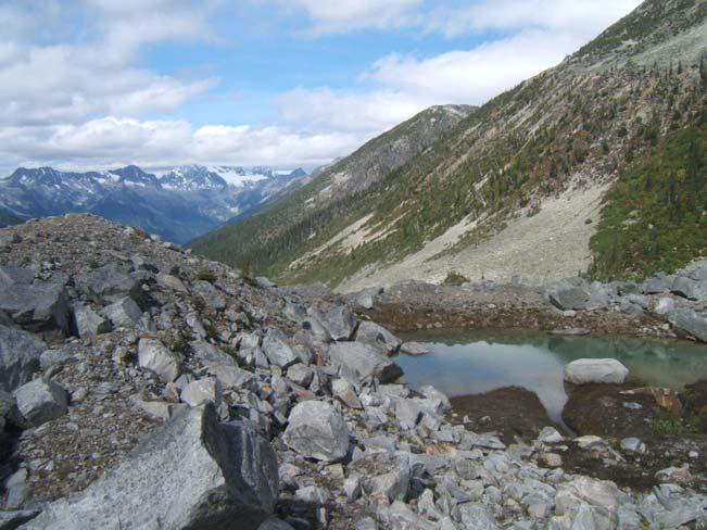
3 Site Description Approximately 75km from Golden, British Columbia, within the Columbia Mountain range in Glacier National Park. Accessible via the Asulkan Valley Trail.
4 The 2 Groups Blair, Derek, Sam, Ahmed, and Martin conducted their research on the lowest two moraines as well as the top most recent moraine. Cali and Kara conducted their research on the top two most recent moraines.
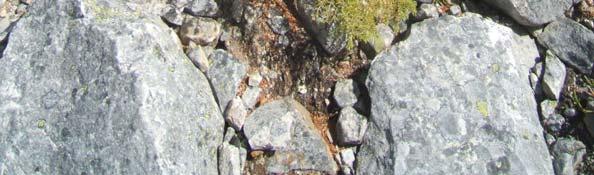
5 Lichenometry Relatively new technique for dating wood, soil and rock. Technique in Canada developed by the late Roland Beschel We We will attempt to date the Asulkan Glacier and its recession using lichenometry on 4 separate moraines
6 Lichenometry Methodology Field measurements Take measurement of lichen thalli in x and y directions with digital caliper Only yellow-green Rh. Geographicum were sampled Only chose largest lichens at each moraine Thalli had to be ellipsoidal or circular Measurements were not taken where one thalli had overtaken another one Did not measure lichen on top of rock 30 thalli samples taken at each moraine Sampling attempted to span entire moraine
7 Results - The Boys Based Based on McCarthy s s growth curve, our 3 moraines dated as follows: Terminal: 270 years (1738) Lower recessional: 153 years (1855) Upper recessional: 102 years (1906)
8 Lichen Growth Curve


9 Lichenometry Methods Upper 2 Moraines Lichen diameters were measured on the entire ridge of the lower moraine and the terminal portion of the upper moraine. Samples were divided into lower, mid and upper sections. The mean lichen diameter was calculated for each of these sections.
10 Results The Girls Ecesis: Ecesis: 35 years (McCarthy, 2003) Lower: Lower: 180 years (1828) Mid: Mid: 140 years (1868) Upper: Upper: 90 years (1918)
11 Lichen growth curve Lower moraine at 180 years old Upper moraine at 90 years old
12 Potential error Underestimates could be due to: Using mean values rather than max thalli size Non-uniform snow cover Overestimates due to: Lichen adjacent to streams Using Using a pre-existing existing growth curve developed for the Illecillewaet Glacier
13 Dendrochronology Dendrochronology has proved to be an invaluable tool for dating events & for providing robust annually resolved paleoenvironmental insights Daniel J(uniper?) Smith, Dendroglaciology Dendrogeomorphology Dendroclimatology
14 Dendroglaciology Reconstructing past glacial activities & maximum glacial extent (Smith & Lewis, 2007)


15 Dendroglaciology The Boys Methods: Initially slight downward angle core root crown interface & minimize age errors Rotten pith cores = corer handle height & standard breast height Tree whorl count for smaller trees Analysis conducted at UVTRL Closest and most relevant data to study area used to extrapolate ecesis intervals: 45 years for sub alpine fir 41 years for mountain hemlock
16 Dendroglaciology Results Terminal Terminal Moraine years (1813) Upper Upper Recessional Moraine years (1903) Lateral Lateral Moraine 97 years (1910)


17 Methods: Dendrochronology The Girls Cored all trees large enough to core Counted whorls of smaller trees Cut down two trees to determine whorl counting accuracy Cut down two scarred treed Used an oblique photo from 1897 to determine ecesis interval

18 Oblique photo showing glacial extent in 1897
19 Dendroglaciology Results The The oldest tree on the lower moraine was 112 years old and the oldest tree on the upper moraine was 31 years old. Ecesis: Ecesis: years Lower Moraine Age: years old ( ) Upper Moraine Age: years old ( ) 1907)
20 Dendrogeomorphology Results There There were two visible scars on both cut trees. They revealed that disturbances (probably avalanches) occurred 12 and 26 years ago.
21 Dendroclimatology Results Three Three distinct germination periods were found by counting seedling whorls: years ago (1973) years ago (1981) years ago (1992)
22 Revelstoke Climate Data and seedling germination
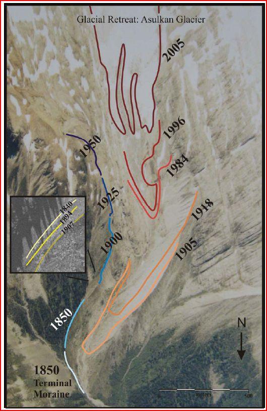
23 Final Cumulative Results Final Final East Asulkan Map.

24 Final Cumulative Results
25 How do we stack up to 2007??? Anastasiades et al. (2007). Terminal Moraine Mid-Recessional Moraine Upper-Recessional Moraine Demidow et al. (2008). Terminal Moraine Lower Recessional Moraine Upper Recessional Moraine
26 Visual Comparison

27 Sources of Error Data Data Collection Height of trees and lichen Aspect of trees and lichen Too many cooks in the kitchen!
28 Sources of Error Ecesis Ecesis and Growth Curves Anastasiades et al. (2007) based their ecesis on a lichen growth curve from Luckman (1977), based in Jasper National Park. This study is based on McCarthy (2003) s s lichen growth curve based on the Illecillewaet glacier. Same Date, Smaller Lichen. Difference?? Moisture Regime. Jasper, Alta. (Mt. Edith Cavell) 394 mm/year Precipitation Golden, BC. (Illecillewaet) 950 mm/year Precipitation

29 Potential Environmental Proximity to streams Natural disturbances Topography Rock type Differences
30 Conclusion Lichenometry and Dendrochronology are effective methods of dating moraine ridges in glacial environments. Growth Growth curves and ecesis rates are spatially variable and regionally independent.
31 Thank-You! Thanks Thanks to Dan, Jim, Bethany, Sarah, Kate, and Lynn for sharing your knowledge and passion of the alpine.
Dating the Cheops Glacier with Lichenometry, Dendrochronology and Air Photo Analyses
 Dating the Cheops Glacier with Lichenometry, Dendrochronology and Air Photo Analyses By: Janek Wosnewski, Sean Hillis, Dan Gregory and Kodie Dewar December 09, 2009 Geography 477 Field School Instructor:
Asulkan Valley Avalanche track. Geography 477 Fall 2007 Penny Simpson, Jessica Paramio, Maciej Stetkiewicz, Ashley Dittmer
 Asulkan Valley Avalanche track Geography 477 Fall 2007 Penny Simpson, Jessica Paramio, Maciej Stetkiewicz, Ashley Dittmer RationaleRationale Objectives Background Methodology ResultsResults Discussion
Retreating Glaciers of the Himalayas: A Case Study of Gangotri Glacier Using Satellite Images
 Retreating Glaciers of the Himalayas: A Case Study of Gangotri Glacier Using 1990-2009 Satellite Images Jennifer Ding Texas Academy of Mathematics and Science (TAMS) Mentor: Dr. Pinliang Dong Department
Exemplar for Internal Achievement Standard Geography Level 1. Conduct geographic research, with direction
 Exemplar for internal assessment resource Geography for Achievement Standard 91011 Exemplar for Internal Achievement Standard Geography Level 1 This exemplar supports assessment against: Achievement Standard
ENVIRONMENTAL HAZARDS OF AVALANCHES: PRELIMINARY RESEARCH IN GLACIER NATIONAL PARK
 ENVIRONMENTAL HAZARDS OF AVALANCHES: PRELIMINARY RESEARCH IN GLACIER NATIONAL PARK Site Focus: Balu Pass, Glacier National Park, B.C. Avalanche path near Balu Pass. (Photo Courtesy of: www.leelau.net/2007/rogerspass/day1/1)
VOLUME CHANGES OF THE GLACIERS IN SCANDINAVIA AND ICELAND IN THE 21st CENTURY
 VOLUME CHANGES OF THE GLACIERS IN SCANDINAVIA AND ICELAND IN THE 21st CENTURY Valentina Radić 1,3 and Regine Hock 2,3 1 Depart. of Earth & Ocean Sciences, University of British Columbia, Vancouver, Canada
NORTH CASCADE SLACIER CLIMATE PROJECT Director: Dr. Mauri S. Pelto Department of Environmental Science Nichols College, Dudley MA 01571
 NORTH CASCADE SLACIER CLIMATE PROJECT Director: Dr. Mauri S. Pelto Department of Environmental Science Nichols College, Dudley MA 01571 INTRODUCTION The North Cascade Glacier-Climate Project was founded
Shaping of North America. Physical Geography II of the United States and Canada. The Last Ice Age. The Ice Age. Pleistocene Polar Ice Cap 2/14/2013
 Physical Geography II of the United States and Canada Prof. Anthony Grande AFG 2012 Shaping of North America The chief shaper of the landscape of North America is and has been running water. Glaciation
Evolution of Ossoue glacier, French Pyrenees: Tools and methods to generate a regional climate-proxy
 Evolution of Ossoue glacier, French Pyrenees: Tools and methods to generate a regional climate-proxy Renaud MARTI ab, Simon GASCOIN a, Thomas HOUET b, Dominique LAFFLY b, Pierre RENE c a CESBIO b GEODE,
GLACIATION. The Last Ice Age (see Chapter 12) and. Pleistocene Ice Cap. Glacial Dynamics 10/2/2012. Laurentide Ice Sheet over NYS
 and. Pleistocene Ice Cap. Glacial Dynamics 10/2/2012. Laurentide Ice Sheet over NYS") GLACIATION and New York State Prof. Anthony Grande The Last Ice Age (see Chapter 1) The Pleistocene Epoch began 1.6 mya. During this time, climates grew colder. There were numerous ice ages starting 100,000000
GLACIATION and New York State Prof. Anthony Grande The Last Ice Age (see Chapter 1) The Pleistocene Epoch began 1.6 mya. During this time, climates grew colder. There were numerous ice ages starting 100,000000
TEACHER PAGE Trial Version
 TEACHER PAGE Trial Version * After completion of the lesson, please take a moment to fill out the feedback form on our web site (https://www.cresis.ku.edu/education/k-12/online-data-portal)* Lesson Title:
The Role of Glaciers in the Hydrologic Regime of the Nepal Himalaya. Donald Alford Richard Armstrong NSIDC Adina Racoviteanu NSIDC
 The Role of Glaciers in the Hydrologic Regime of the Nepal Himalaya Donald Alford Richard Armstrong NSIDC Adina Racoviteanu NSIDC Outline of the talk Study area and data bases Area altitude distributed
glacier Little Ice Age continental glacier valley glacier ice cap glaciation firn glacial ice plastic flow basal slip Chapter 14
 Little Ice Age glacier valley glacier continental glacier ice cap glaciation firn glacial ice plastic flow basal slip glacial budget zone of accumulation zone of wastage glacial surge abrasion glacial
The Regents of the University of Colorado, a body corporate, contracting on behalf of the University of Colorado at Boulder for the benefit of INSTAAR
 The Regents of the University of Colorado, a body corporate, contracting on behalf of the University of Colorado at Boulder for the benefit of INSTAAR A Chronology of Late Holocene Glacier Fluctuations
GLACIER STUDIES OF THE McCALL GLACIER, ALASKA
 GLACIER STUDIES OF THE McCALL GLACIER, ALASKA T John E. Sater* HE McCall Glacier is a long thin body of ice shaped roughly like a crescent. Its overall length is approximately 8 km. and its average width
Using LiDAR to study alpine watersheds. Chris Hopkinson, Mike Demuth, Laura Chasmer, Scott Munro, Masaki Hayashi, Karen Miller, Derek Peddle
 Using LiDAR to study alpine watersheds Chris Hopkinson, Mike Demuth, Laura Chasmer, Scott Munro, Masaki Hayashi, Karen Miller, Derek Peddle Light Detection And Ranging r t LASER pulse emitted and reflection
Late Holocene glacial activity of Bridge Glacier, British Columbia Coast Mountains
 1753 Late Holocene glacial activity of Bridge Glacier, British Columbia Coast Mountains Sandra M. Allen and Dan J. Smith Abstract: Bridge Glacier is a prominent eastward-flowing valley glacier located
The Use of Dendrochronology to Determine Avalanche Frequency Along the Avalanche Path East of Balu Peak, Within the Balu Pass Trail, Roger's Pass, BC.
 1 The Use of Dendrochronology to Determine Avalanche Frequency Along the Avalanche Path East of Balu Peak, Within the Balu Pass Trail, Roger's Pass, BC. Allison Dick, Donald Mcfarlane, and Robyn McGregor
The Portland State University study of shrinking Mt. Adams glaciers a good example of bad science.
 The Portland State University study of shrinking Mt. Adams glaciers a good example of bad science. Don J. Easterbrook, Dept. of Geology, Western Washington University, Bellingham, WA The recent Portland
Glaciers Earth 9th Edition Chapter 18 Mass wasting: summary in haiku form Glaciers Glaciers Glaciers Glaciers Formation of glacial ice
 1 2 3 4 5 6 7 8 9 10 11 12 13 14 15 Earth 9 th Edition Chapter 18 Mass wasting: summary in haiku form Ten thousand years thence big glaciers began to melt - called "global warming." are parts of two basic
Predicting a Dramatic Contraction in the 10-Year Passenger Demand
 Predicting a Dramatic Contraction in the 10-Year Passenger Demand Daniel Y. Suh Megan S. Ryerson University of Pennsylvania 6/29/2018 8 th International Conference on Research in Air Transportation Outline
PREPARE TO STOP DIP ROUGH ROAD SPEED ZONE AHEAD DANGER STOP AT PULLOFF ONLY 30 MUXIMUM SLOW TRAFFIC KEEP RIGHT. FOrm SINGLE LINE.
 SPEED ZONE AHEAD PREPARE TO STOP DANGER STOP AT PULLOFF ONLY 30 SLOW TRAFFIC KEEP RIGHT Maple Leaf FOrm SINGLE LINE DIP ROUGH ROAD MUXIMUM 30 (1101) éé 7/1 7/2 7/3 7/4 7/5 7/6 7/7~8 7/9 7/10 Monashe Mountain
Robson Valley Avalanche Tract Mapping Project
 Robson Valley Avalanche Tract Mapping Project Prepared for: Chris Ritchie Ministry of Water Land and Air Protection 325 1011 4th Avenue Prince George, BC. V2L3H9 and Dale Seip Ministry of Forests 1011
GEOGRAPHY OF GLACIERS 2
 GEOGRAPHY OF GLACIERS 2 Roger Braithwaite School of Environment and Development 1.069 Arthur Lewis Building University of Manchester, UK Tel: UK+161 275 3653 r.braithwaite@man.ac.uk 09/08/2012 Geography
How Glaciers Change the World By ReadWorks
 How Glaciers Change the World How Glaciers Change the World By ReadWorks Glaciers are large masses of ice that can be found in either the oceans or on land. These large bodies of frozen water have big
Prairie Drought: Precedents and Prospects
 Prairie Drought: Precedents and Prospects Dave Sauchyn Prairie Adaptation Research Collaborative, University of Regina Managing Climate and Weather Risks for Peace River District Agriculture, Grande Prairie,
TO THE WORLD HERITAGE LIST. Convention concerning the Protection of the World Cultural and Natural Heritage
 NOMINATION TO THE WORLD HERITAGE LIST Convention concerning the Protection of the World Cultural and Natural Heritage Name I CANADIAN ROCKIES Identification No, 304 Date received by WH Secretariat, 23.12.83
1.4 Understand how moving ice acts as an agent of erosion and deposition. (Chap. 2)
") 1.4 Understand how moving ice acts as an agent of erosion and deposition. (Chap. 2) There are two types of glaciation. Alpine Glaciation Continental Glaciation Distinguish between the terms alpine glaciation
1.4 Understand how moving ice acts as an agent of erosion and deposition. (Chap. 2) There are two types of glaciation. Alpine Glaciation Continental Glaciation Distinguish between the terms alpine glaciation
Childhood Obesity in Wiltshire:
 Childhood Obesity in Wiltshire: National Child Measurement Programme (NCMP) Analysis 2011/12 2013/14 Public Health Intelligence Team December 2014 Document Prepared by Simon Hodsdon Public Health Analyst
Snowmobile Trail Signing REF: DNR Trail Signing Handbook
 AWSC FALL WORKSHOP TRAIL SIGNING & MAINTENANCE NOVEMBER 5, 2011 Workshop presenters: Larry Erickson, AWSC Trails Committee Chairman, Iron County Director Dave Peterson, Langlade County Director Snowmobile
American Airlines Next Top Model
 Page 1 of 12 American Airlines Next Top Model Introduction Airlines employ several distinct strategies for the boarding and deboarding of airplanes in an attempt to minimize the time each plane spends
ENSC454 Snow and Ice: Glaciers April Roger Wheate (NRES)
") ENSC454 Snow and Ice: Glaciers April 1 2015 Roger Wheate (NRES) Roger.Wheate@unbc.ca Sólheimajökull, Iceland The main purpose of snow: it makes glaciers April 1 other uses of snow April 1 uses of glaciers:
ENSC454 Snow and Ice: Glaciers April 1 2015 Roger Wheate (NRES) Roger.Wheate@unbc.ca Sólheimajökull, Iceland The main purpose of snow: it makes glaciers April 1 other uses of snow April 1 uses of glaciers:
along a transportation corridor in
 Rockfall hazard and risk assessment along a transportation corridor in the Nera Valley, Central Italy Presentation on the paper authored by F. Guzzetti and P. Reichenbach, 2004 Harikrishna Narasimhan Eidgenössische
47I THE LAS ANIMAS GLACIER.
 THE LAS ANIMAS GLACIER. ONE of the largest of the extinct glaciers of the Rocky Mountains was that which occupied the valley of the Las Animas river. This stream originates in the San Juan mountains in
Labrador - Island Transmission Link Target Rare Plant Survey Locations
 27-28- Figure: 36 of 55 29-28- Figure: 37 of 55 29- Figure: 38 of 55 #* Figure: 39 of 55 30- - east side Figure: 40 of 55 31- Figure: 41 of 55 31- Figure: 42 of 55 32- - secondary Figure: 43 of 55 32-
Revised Draft: May 8, 2000
 Revised Draft: May 8, 2000 Accepted for publication by the International Association of Hydrological Sciences. Paper will be presented at the Debris-Covered Glaciers Workshop in September 2000 at the University
GEOSPATIAL ANALYSIS OF GLACIAL HAZARDS PRONE AREAS OF SHIGAR AND SHAYOK BASINS OF PAKISTAN. By Syed Naseem Abbas Gilany
 GEOSPATIAL ANALYSIS OF GLACIAL HAZARDS PRONE AREAS OF SHIGAR AND SHAYOK BASINS OF PAKISTAN By Syed Naseem Abbas Gilany PRESENTATION OUTLINE Introduction Problem Statement / Rationale Objectives Material
2010 International Snow Science Workshop
 USING GIS AND GOOGLE EARTH FOR THE CREATION OF THE GOING-TO-THE-SUN ROAD AVALANCHE ATLAS, GLACIER NATIONAL PARK, MONTANA, USA Erich H. Peitzsch 1*, Daniel B. Fagre 1, Mark Dundas 2 1 U.S. Geological Survey,
2.0 PARK VISION AND ROLES
 2.0 PARK VISION AND ROLES 2.1 Significance in the Protected Area System Marble Range and Edge Hills provincial parks protect 6.8% of the Pavillion Ranges Ecosection, which is located in the Southern Interior
Cost-Effective Flight Test Training Using In-House Resources: An application to the HAF Academy
 Cranfield University Alumni Event and Defense Education Conference Athens, 1 June 2017 Cost-Effective Flight Test Training Using In-House Resources: Cpt (HAF) Aristidis Antonakis HAF Electronics Depot
Victor Lake Park. Management Plan
 Victor Lake Park Management Plan November 2012 Victor Lake Park Management Plan Approved by: Jeff Leahy, Regional Director Thompson Cariboo Region BC Parks March 28, 2012 Date Brian Bawtinheimer, Executive
HIKING IN THE CANADIAN ROCKIES
 HIKING IN THE CANADIAN ROCKIES Distance Time Elevation y MORAINE LAKE TRAILS THE ROCKPILE 0.8 km (0.5 mi) 20 min 30 m (98 ft) Located adjacent to the Lodge, the short interpretive trail up the Rock Pile
Q: What is a period of time whereby the average global temperature has decreased? Q: What is a glacier?
 Q: What is a glacier? A: A large sheet of ice which lasts all year round. Q: What is a period of time whereby the average global temperature has decreased? A: A glacial. Q: What is an interglacial? Q:
Glacial lakes as sentinels of climate change in Central Himalaya, Nepal
 Glacial lakes as sentinels of climate change in Central Himalaya, Nepal Sudeep Thakuri 1,2,3, Franco Salerno 1,3, Claudio Smiraglia 2,3, Carlo D Agata 2,3, Gaetano Viviano 1,3, Emanuela C. Manfredi 1,3,
Railway-Highway Crossing at Grade Regulations: Guidelines for British Columbia s Provincial Heritage Railways
 Railway-Highway Crossing at Grade Regulations: Guidelines for British Columbia s Provincial Heritage Railways SHORT TITLE 1. These Guidelines may be cited as the Railway-Highway Crossing at Grade Guidelines.
Glaciers and Glaciation Earth - Chapter 18 Stan Hatfield Southwestern Illinois College
 Glaciers and Glaciation Earth - Chapter 18 Stan Hatfield Southwestern Illinois College Glaciers Glaciers are parts of two basic cycles: 1. Hydrologic cycle 2. Rock cycle A glacier is a thick mass of ice
Tool: Overbooking Ratio Step by Step
 Tool: Overbooking Ratio Step by Step Use this guide to find the overbooking ratio for your hotel and to create an overbooking policy. 1. Calculate the overbooking ratio Collect the following data: ADR
AVIATION INVESTIGATION REPORT A05P0032 SETTLING WITH POWER ROLL-OVER
 Transportation Safety Board of Canada Bureau de la sécurité des transports du Canada AVIATION INVESTIGATION REPORT A05P0032 SETTLING WITH POWER ROLL-OVER TASMAN HELICOPTERS LTD. BELL 212 (HELICOPTER) C-GEEC
Glacier fluctuations during the past millennium in Garibaldi Provincial Park, southern Coast Mountains, British Columbia
 Glacier fluctuations during the past millennium in Garibaldi Provincial Park, southern Coast Mountains, British Columbia Johannes Koch, John J. Clague, and Gerald D. Osborn 1215 Abstract: The Little Ice
Kinder Morgan Canada Trans Mountain Pipeline Expansion Project
 Kinder Morgan Canada Trans Mountain Pipeline Expansion Project Lands Taken Up Inventory May 2015 LIMITATION Information collected for this Study is the sole property of the Michel First Nation. The information
Glaciers. Reading Practice
 Reading Practice A Glaciers Besides the earth s oceans, glacier ice is the largest source of water on earth. A glacier is a massive stream or sheet of ice that moves underneath itself under the influence
Challenges in the Airspace Safety Monitoring
 Challenges in the Airspace Safety Monitoring Antar Bandyopadhyay (Based on joint project with BOBASMA, AAI & ISI) Theoretical Statistics and Mathematics Unit Indian Statistical Institute, New Delhi and
A Study of Ancient Resharpening
 A Study of Ancient Resharpening By James R. Bennett, Jim Fisher, & Dan Long Published in Identifying Altered Ancient Flint Artifacts: Relics & Reproductions Series Book II by James R. Bennett The goal
Reservoir Tin workings
 The workings are quite over-grown and covered in moss, suggesting that they date to the earliest period of mining. This is supported by the fact that their head race was cut off by the reservoir (D49/47)
Bridge River Delta Park. Management Plan. Final Public Review Draft
 Bridge River Delta Park Management Plan Final Public Review Draft March 2016 Bridge River Delta Park Management Plan Approved by: Jeff Leahy Regional Director Thompson Cariboo Region BC Parks Date Brian
Original Research Paper DETERMINATION OF HAND FROM A FINGERPRINT
 Original Research Paper DETERMINATION OF HAND FROM A FINGERPRINT K.R. Nagesh,Professor & Head, Department of Forensic Medicine, Father Muller Medical College, * Pratik Sahoo, Medical Graduate, Kasturba
5 MAP SPECIFICATION FOR SKI-ORIENTEERING
 5 MAP SPECIFICATION FOR SKI-ORIENTEERING 5.1 General Maps for ski orienteering are based on the specifications for foot-orienteering maps. However in order to meet the specific requirements put on the
AN AVALANCHE CHARACTERIZATION CHECKLIST FOR BACKCOUNTRY TRAVEL DECISIONS. Roger Atkins* Canadian Mountain Holidays
 AN AVALANCHE CHARACTERIZATION CHECKLIST FOR BACKCOUNTRY TRAVEL DECISIONS Roger Atkins* Canadian Mountain Holidays ABSTRACT: This paper presents a checklist to assess the character of likely avalanche activity
Pocahontas Area Map Jasper INFORMATION CENTRES Lake Louise Field Golden Banff
 Pocahontas Miette Hot Springs Area Map Jasper Maligne JASPER Columbia Icefield Saskatchewan River Crossing INFORMATION CENTRES Banff National Park Louise Kootenay Park Lodge Yoho National Park Columbia
AURORA WILDLIFE RESEARCH
 AURORA WILDLIFE RESEARCH Kim Poole 2305 Annable Rd. Nelson, BC, V1L 6K4 Canada Tel: (250) 825-4063; Fax: (250) 825-4073 e-mail: klpoole@shaw.ca 27 April 2005 Mike Gall Conservation Specialist and Glenn
Chapter 7 Snow and ice
 Chapter 7 Snow and ice Throughout the solar system there are different types of large ice bodies, not only water ice but also ice made up of ammonia, carbon dioxide and other substances that are gases
THE NET VOLUMETRIC LOSS OF GLACIER COVER WITHIN THE BOW VALLEY ABOVE BANFF, /
 THE NET VOLUMETRIC LOSS OF GLACIER COVER WITHIN THE BOW VALLEY ABOVE BANFF, 1951-1993 1/ ABSTRACT CHRIS HOPKINSON 2/ Three methods have been used to explore the volumetric change of glaciers in the Bow
The dynamic response of Kolohai Glacier to climate change
 Article The dynamic response of Kolohai Glacier to climate change Asifa Rashid 1, M. R. G. Sayyed 2, Fayaz. A. Bhat 3 1 Department of Geology, Savitribai Phule Pune University, Pune 411007, India 2 Department
I. Types of Glaciers 11/22/2011. I. Types of Glaciers. Glaciers and Glaciation. Chapter 11 Temp. B. Types of glaciers
 Why should I care about glaciers? Look closely at this graph to understand why we should care? and Glaciation Chapter 11 Temp I. Types of A. Glacier a thick mass of ice that originates on land from the
HYDROLOGY OF GLACIAL LAKES, FORT SISSETON AREA
 PROC. S.D. ACAD. SCI., VOL. 77 (1998) 59 HYDROLOGY OF GLACIAL LAKES, FORT SISSETON AREA Perry H. Rahn Department of Geology & Geological Engineering South Dakota School of Mines and Technology Rapid City,
Northeast Stoney Trail In Calgary, Alberta
 aci Acoustical Consultants Inc. 5031 210 Street Edmonton, Alberta, Canada T6M 0A8 Phone: (780) 414-6373, Fax: (780) 414-6376 www.aciacoustical.com Environmental Noise Computer Modelling For Northeast Stoney
Photopoint Monitoring in the Adirondack Alpine Zone
 Photopoint Monitoring in the Adirondack Alpine Zone Julia Goren (PI) and Seth Jones Adirondack High Peaks Summit Steward Program Adirondack Mountain Club summit@adk.org PO Box 867, Lake Placid, NY 12946
VISITOR RISK MANAGEMENT APPLIED TO AVALANCHES IN NEW ZEALAND
 VISITOR RISK MANAGEMENT APPLIED TO AVALANCHES IN NEW ZEALAND Don Bogie*, Department of Conservation, Christchurch, New Zealand Mike Davies, Department of Conservation, Wellington, New Zealand ABSTRACT:
Accuracy of Flight Delays Caused by Low Ceilings and Visibilities at Chicago s Midway and O Hare International Airports
 Meteorology Senior Theses Undergraduate Theses and Capstone Projects 12-2016 Accuracy of Flight Delays Caused by Low Ceilings and Visibilities at Chicago s Midway and O Hare International Airports Kerry
Pump Fillage Calculation (PFC) Algorithm for Well Control
 Algorithm for Well Control") 6 th Annual Sucker Rod Pumping Workshop Wyndham Hotel, Dallas, Texas September 14 17, 2010 Pump Fillage Calculation (PFC) Algorithm for Well Control Victoria Ehimeakhe, Ph.D. Weatherford Introduction For
6 th Annual Sucker Rod Pumping Workshop Wyndham Hotel, Dallas, Texas September 14 17, 2010 Pump Fillage Calculation (PFC) Algorithm for Well Control Victoria Ehimeakhe, Ph.D. Weatherford Introduction For
2010 International Snow Science Workshop
 MAPPING EXPOSURE TO AVALANCHE TERRAIN Cam Campbell* and Peter Marshall Canadian Avalanche Centre, Revelstoke, British Columbia ABSTRACT: During the winter of 2009-10, several signs were created in collaboration
DR1. OFFSET MEASUREMENTS OF DISPLACED FEATURES ALONG THE DENALI FAULT AND ERROR CALCULATIONS
 DR1. OFFSET MEASUREMETS OF DISPLACED FEATURES ALOG THE DEALI FAULT AD ERROR CALCULATIOS The Denali fault trace is marked by a red line in all the photos. Black and white air photos were taken during August
Guidelines for Snow Avalanche Risk Determination and Mapping. David McClung University of British Columbia
 Guidelines for Snow Avalanche Risk Determination and Mapping David McClung University of British Columbia Why do we need guidelines? Costs: 14 fatalities/year, $0.5 M/year property damage, $10 M/year avalanche
New measurements techniques
 2 nd Asia CryoNetWorkshop New measurements techniques Xiao Cunde (SKLCS/CAS and CAMS/CMA) Feb.5, 2016, Salekhard, Russia Outline Definition of New Some relative newly-used techniques in China -- Eddy covariance
1 Introduction 2 2 Acknowledgements 2 3 Differences between Green Star SA rating tools 2 4 About the Calculator 2 5 How to Use the Calculator 2
 Green Star SA COMMUTING MASS TRANSPORT GUIDE 1 Introduction 2 2 Acknowledgements 2 3 Differences between Green Star SA rating tools 2 4 About the Calculator 2 5 How to Use the Calculator 2 5.1 Step 1:
Recrystallization of snow to form LARGE. called FIRN: like packed snowballs. the weight of overlying firn and snow.
 Chapter 11 Glaciers BFRB P. 103-104, 104, 108, 117-120120 Process of Glacier Formation Snow does NOT melt in summer Recrystallization of snow to form LARGE crystals of ice (rough and granular) called
Settlements around Indus Threatened With rise in temperatures, glaciers receding, increase in rainfall and tributaries changing course settlements
 INTRODUCTION Over the centuries the Indus has been the life line for several civilizations. In Ladakh most of the villages have come up on the north bank along the tributaries that are fed by the glacial
2000 SOUTHERN EAST KOOTENAY GOAT AERIAL SURVEY
 COLUMBIA BASIN FISH & WILDLIFE COMPENSATION PROGRAM 2000 SOUTHERN EAST KOOTENAY GOAT AERIAL SURVEY PREPARED BY Robert Halko, P.Ag., Keith Hebert FOR Columbia Basin Fish & Wildlife Compensation Program
Clinical results using the Holladay 2 intraocular lens power formula
 Clinical results using the Holladay 2 intraocular lens power formula Kenneth J. Hoffer, MD ABSTRACT Purpose: To analyze the accuracy of the Holladay 2 formula, which has been proposed as an improvement
BLASTING GLACIAL ICE AND SNOW ABSTRACT
 BLASTING GLACIAL ICE AND SNOW HERB BLEUER ABSTRACT This presentation, with the aid of slides, is about methods of blasting large quantities of glacial ice and snow. The project illustrated here involved
CRAZY HORSE TRAIL GUIDE
 CRAZY HORSE TRAIL GUIDE Abridged Version: July 2016 This is a short form of our interpretive trail guide for the Crazy Horse Trail. The full version of the guide has a more detailed description of the
WATER, ICE, AND METEOROLOGICAL MEASUREMENTS AT SOUTH CASCADE GLACIER, WASHINGTON, BALANCE YEARS
 WATER, ICE, AND METEOROLOGICAL MEASUREMENTS AT SOUTH CASCADE GLACIER, WASHINGTON, 2-1 BALANCE YEARS U.S. GEOLOGICAL SURVEY Water-Resources Investigations Report 2-4165 South Cascade Glacier, looking approximately
Customer Satisfaction Tracking Annual Report British Columbia Ferry Services Inc.
 Customer Satisfaction Tracking Annual Report 0 British Columbia Ferry Services Inc. Presented to: British Columbia Ferry Services Inc. Victoria, British Columbia 0 05 West Second Avenue Vancouver BC V6H
Environmental Development of River Road Ranch
 Environmental Development of River Road Ranch New Braunfels, Texas Alix Scarborough GEO 3426 April 2012 Introduction The 2,400-acre Word-Borcher ranch has been owned by the Word family since 1941. Located
Pillar Park. Management Plan
 Pillar Park Management Plan January 2014 Pillar Park Management Plan Approved by: Jeff Leahy Regional Director Thompson Cariboo Region BC Parks January 9, 2014 Date Brian Bawtinheimer Executive Director
AGAP Antarctic Research Project Visualizing Data Learning About Antarctica From RADAR Data? Student Version
 AGAP Antarctic Research Project Visualizing Data Learning About Antarctica From RADAR Data? Student Version Name Date Image of Subglacial Lake network courtesy of NSF Ice Sheet: A large glacier that covers
Late Holocene glacial activity in Manatee Valley, southern Coast Mountains, British Columbia, Canada
 603 Late Holocene glacial activity in Manatee Valley, southern Coast Mountains, British Columbia, Canada Lindsey Koehler and Dan J. Smith Abstract: The dendroglaciologic and lichenometric research methodologies
THRESHOLD GUIDELINES FOR AVALANCHE SAFETY MEASURES
 BRITISH COLUMBIA MINISTRY OF TRANSPORTATION & INFRASTRUCTURE AVALANCHE & WEATHER PROGRAMS THRESHOLD GUIDELINES FOR AVALANCHE SAFETY MEASURES British Columbia Ministry of Transportation & Infrastructure
HIGH RESOLUTION TREE-RING BASED SPATIAL RECONSTRUCTIONS OF SNOW AVALANCHE ACTIVITY IN GLACIER NATIONAL PARK, MONTANA, USA
 HIGH RESOLUTION TREE-RING BASED SPATIAL RECONSTRUCTIONS OF SNOW AVALANCHE ACTIVITY IN GLACIER NATIONAL PARK, MONTANA, USA Gregory T. Pederson (1,2) *, Blase A. Reardon (1), Christian J. Caruso (1,2), and
In the 1860s, with a movement to
 Trains Railway crew on hand car, 1888. In the 1860s, with a movement to push for Canadian independence gaining ground, the British government passed legislation establishing the Dominion of Canada. At
Going-to-the-Sun Road, Glacier National Park, MT, USA Avalanche Path Atlas
 Going-to-the-Sun Road, Glacier National Park, MT, USA Avalanche Path Atlas Erich H. Peitzsch Daniel B. Fagre USGS Northern Rocky Mountain Science Center West Glacier, MT, USA Introduction... 2 Overview
Dynamic Planet C Test
 Northern Regional: January 19 th, 2019 Dynamic Planet C Test Name(s): Team Name: School Name: Team Number: Rank: Score: Dynamic Planet B/C Glaciers (87 total points) Multiple choice/fill in the blank (23
glacial drift: all deposits associated with glaciation; covers 8% of Earth s surface above sealevel, and 25% of North America
 Glacial depositional features glacial drift: all deposits associated with glaciation; covers 8% of Earth s surface above sealevel, and 25% of North America i) nonstratified drift till: transported & deposited
Climate Change and State of Himalayan Glaciers: Issues, Challenges and Facts
 Climate Change and State of Himalayan Glaciers: Issues, Challenges and Facts D.P. Dobhal dpdobhal@wihg.res.in Wadia Institute of Himalayan Geology Dehra Dun Major Issues Are the Himalayan glaciers receding
The Physical Geography of Long Island
 The Physical Geography of Long Island A Bit About Long Island Length 118 miles Brooklyn to Montauk Geo202 Spring 2012 Width 23 miles at it s widest Area 1,400 square miles Formation of Long Island River
National Forest: Snoqualmie National Forest State: WA Counties: King, Snohomish General Location: Central Washington Cascade Range Acres: 105,561
 Wild Sky Wilderness Air Quality Report National Forest: Snoqualmie National Forest State: WA Counties: King, Snohomish General Location: Central Washington Cascade Range Acres: 105,561 Page 1 of 5 Wilderness
Geomorphology. Glacial Flow and Reconstruction
 Geomorphology Glacial Flow and Reconstruction We will use simple mathematical models to understand ice dynamics, recreate a profile of the Laurentide ice sheet, and determine the climate change of the
Figure 1. Location of Rocky Mountain National Park in north-central Colorado, in relation to surrounding population centers, and topography
 Figure 1. Location of Rocky Mountain National Park in north-central Colorado, in relation to surrounding population centers, and topography (elevation in meters). Figure 2. Elk ranges as delimited by drawing
Barbara Borowiecki University of Wisconsin - Milwaukee
 POTENTIAL SIGNIFICANCE OF DRu}~IN FIELD MODIFICATION Barbara Borowiecki University of Wisconsin - Milwaukee Spatial characteristics of numerous drumlin fields, including the one in Wisconsin, have been
Dating the Moraines and Recession of Athabasca and Dome Glaciers, Alberta, Canada
 Arctic and Alpine Research ISSN: 0004-0851 (Print) 2325-5153 (Online) Journal homepage: https://www.tandfonline.com/loi/uaar19 Dating the Moraines and Recession of Athabasca and Dome Glaciers, Alberta,