event map book SYDNEY 50KM SYDNEY 100KM
|
|
|
- Tiffany Floyd
- 6 years ago
- Views:
Transcription


1 event map book SYDNEY 50KM SYDNEY 100KM SATURDAY 26 SUNDAY 27 AUGUST 2017 BOBBIN HEAD TO THE HARBOUR FRIDAY 25 SUNDAY 27 AUGUST 2017 THE HAWKESBURY TO THE HARBOUR NATIONAL PARTNERS


2 WELCOME 100KM ONLY 100km START POINT BROOKLYN 100KM ONLY THIS MAP BOOK HAS BEEN PREPARED TO GUIDE YOU THROUGH THE EVENT ROUTE, CHECKPOINT BY CHECKPOINT. IT IS DESIGNED TO BE YOUR PRIMARY NAVIGATIONAL AID DURING PRE-EVENT TRAINING AND THROUGHOUT THE EVENT WEEKEND. Oxfam Trailwalker is a tough event. Much of the trail covers difficult terrain and you will be exposed to the elements for many hours. It requires appropriate and committed training and preparation. By registering for Oxfam Trailwalker, you have accepted responsibility for your own conduct and for the risks inherent in such a demanding endurance event. A planned approach, adequate training, familiarity with the trail and a thorough knowledge of the event rules and the safety information provided on the website and in the Training and Preparation Guide will help to minimise risk to you and your team. We hope you enjoy Oxfam Trailwalker! rest stop 50KM ONLY TIMBARRA RD (END OF WARRIMOO TRACK EXIT) 50km START POINT BOBBIN HEAD 100KM & 50KM 100KM ONLY 100KM ONLY 100KM & 50KM 100KM & 50KM ARARAT RESERVE 100KM & 50KM CHECKPOINT FACILITIES 100KM START PARSLEY BAY, BROOKLYN CHECKPOINT MUOGAMARRA RURAL FIRE STATION, COWAN CHECKPOINT BEROWRA COMMUNITY CENTRE, BEROWRA FIRST AID BASIC FOOD FOR TEAMS^ WATER NO Cold Hot & cold Hot & cold CHECKPOINT BOBBIN HEAD, KU-RING-GAI CHASE NATIONAL PARK Hot & cold 50KM START BOBBIN HEAD REST STOP (50KM ONLY) TIMBARRA RD (END OF WARRIMOO TRACK EXIT) CHECKPOINT ST IVES SHOWGROUND, ST IVES CHECKPOINT FRENCHS FOREST SHOWGROUND, FRENCHS FOREST CHECKPOINT DAVIDSON PARK, GARIGAL NATIONAL PARK CHECKPOINT ARARAT RESERVE, FRENCHS FOREST FINISH TANIA PARK, BALGOWLAH HEIGHTS SUPPORT CREW ACCESS* limited NO PRIVATE CAMPING NO NO NO NO Cold NO NO Cold NO NO NO Hot & cold Hot & cold Hot & cold Hot & cold Hot & cold NO NO NO NO TRAIL PROFILE 700 DIFFICULTY RATING: See USING THIS MAP BOOK for details on the rating system used. metres KM START PARSLEY BAY MUOGAMARRA RFS 50KM START BOBBIN HEAD BEROWRA COMMUNITY CENTRE BOBBIN HEAD ST IVES SHOWGROUND FRENCHS FOREST SHOWGROUND DAVIDSON PARK ARARAT RESERVE TANIA PARK km 11.9km 15.2km 15.3km 12.4km 11.3km 7.9km 10.3km 0KM 0KM 15.7KM 27.6KM 42.8KM 20.5KM 31.8KM 39.7KM 58.1KM 70.5KM 81.8KM 89.7KM 50KM 100KM * The 50km distance does not include the trail loop to/from Checkpoint 4 ^ Additional food vendors, sausage sizzles, etc, will be provided at some checkpoints for an additional cost in some instances. These will be detailed in the final briefing notes provided approximately 10 days prior to the event. * The restrictive size of the checkpoints allows only one vehicle per team with restrictions on the type and, particularly, the size of vehicles. No trailers, towed caravans or vehicles longer than one-and-a-half standard cars (such as large campervans) are allowed. The one vehicle per team rule will be enforced at some checkpoints.
3 USING THIS MAP BOOK THIS MAP BOOK USES TOPOGRAPHICAL MAPS TO COMMUNICATE THE TRAIL ROUTE. IF YOU HAVEN T USED TOPOGRAPHICAL MAPS PREVIOUSLY, YOU SHOULD SPEND SOME TIME BECOMING FAMILIAR WITH THE CHARACTERISTICS OF THE MAPS USED IN THIS BOOKLET AND UNDERTAKE FURTHER READING TO INCREASE YOUR NAVIGATION SKILLS BEFORE VENTURING OUT ON THE TRAIL. Below is some basic advice adapted from the Geoscience Australia educational booklet Map Reading Guide: How to Use Topographic Maps, which is available from MAP SCALE The maps contained in this booklet are scaled 1:25,000 (unless otherwise indicated), which means that each centimetre represented on the map is 25,000 centimetres (or 250 metres) on the ground. CONTOURS Topographical maps use contour lines, which join points of equal height to represent the relief on the terrain depicted. If the contour lines are close together, the terrain is steep. Contour lines that are far apart indicate land with gentle slopes. It is also worth being aware of the contour interval, which is the vertical distance between adjacent contour lines. This information allows the user to determine altitude at any point on the map. WHICH WAY IS NORTH? To assist in making correct directional decisions, the use of a magnetic compass is highly recommended for anyone who ventures into the bush. A compass works on the principle that the pivoting magnetised needle (or the north point of the swinging dial) always points to the north magnetic pole. An icon is included on topographical maps indicating the direction of grid north, so the beginner map user can use their compass to orient their map to the north before confidently navigating their way along their intended route. MAP COORDINATES AND GRID REFERENCES Topographical maps show coordinates in two ways: geographical coordinates (given as latitude and longitude); or as grid coordinates (given as easting and northing values). These coordinates are useful to either find or express a location on the map. For simplicity, grid coordinates will be used in this map book to reference points of directional significance and for you to communicate your position in an emergency. Grid lines are the equally spaced vertical and horizontal intersecting lines superimposed over the maps. The vertical grid lines that run north-south are known as eastings, and the horizontals running east-west are known as northings. Each grid line is numbered at the edge of the map and the distance between the adjacent grid lines represents one kilometre. To reference a point on the map, a six-figure grid reference will specify the position to an accuracy of one-tenth of the grid interval (or to within 100 metres). To create a six-figure grid reference you need to: 1. Locate the easting or vertical grid line to the left of the point of interest and read the two figure easting value from the edge of the map. This number becomes the first two digits in the six figure reference. 2. Visually divide the grid square that contains the point of interest by 10 increments. Estimate the number of increments from the vertical grid line to the point. This number (0 to 9) becomes the third digit in the six-figure reference. 3. Locate the northing or horizontal grid line below the point of interest and add the two figure northing digits to the reference. 4. Estimate the number of increments up from the horizontal grid line to the point. This digit completes the six-figure grid reference. DIFFICULTY RATING The difficulty ratings in this map book have been developed using the Australian Walking Track Grading System, which forms part of the national industry standard to assist walkers in judging the suitability of trails to their walking ability. Each section is graded from its hardest component; it may have some easier components than the ultimate grade. For further details about the grading system employed, search Australian Walking Track Grading System online. SYMBOLS USED ON THE MAPS


4 TRAIL ESSENTIALS THE INFORMATION BELOW CONTAINS KEY POINTS TO REMEMBER WHEN YOU ARE OUT ON THE TRAIL. ADDITIONAL SAFETY INFORMATION IS PROVIDED IN THE TRAINING AND PREPARATION GUIDE AND ON THE WEBSITE. TRAIL ETIQUETTE You share the walking trails used for the event with the general public. Be considerate of other users at all times. Always respect the requests of landowners and land managers. In national parks, you must abide by the conditions of park entry. MOBILE RECEPTION Mobile phone reception varies along the trail and there are some areas of the trail where mobile phones may not have any reception. Telstra currently has the best coverage. To improve your team s chances of having mobile reception during training and the event, we recommend all teams carry phones connected to at least two different network providers. NIGHT WALKING Walking at night requires special vigilance on the part of all team members to reduce the risk of injury. All team members must carry a head torch with extra batteries. With the National Parks area closed to the public at night, we highly recommend gaining some night training at one of our Oxfam Trailwalker Training events. HIGH TIDES & FLASH FLOODING Certain sections of the trail may be subject to high tides or flash flooding (particularly sections 4, 5 and 6). You should exercise extreme caution when at water crossings as water levels can rise rapidly. You should not attempt to cross any swollen or rapidly flowing waterways. When planning your training walks, visit the NSW Roads & Maritime website for tide tables. ROAD CROSSINGS The trail crosses public roads throughout the route. Always use pedestrian lights where available. Take care when crossing or walking alongside roads during training and the event. During the event, the instructions provided by our marshals and the signage at each crossing must be followed to ensure your safety. FIRST AID Each team is required to carry a first aid kit, including a thermal blanket for each team member and pressure bandages to treat injuries such as sprains, blisters, cuts and snake or spider bites. Snakes are a real danger on the event trail during the summer months when you are training. Left alone and unprovoked, snakes present little danger, however, should someone be bitten, you must be aware of the correct treatment. Team members are encouraged to learn basic first aid techniques and be aware of each other s pre-existing health concerns or injuries. HYDRATION Proper hydration is critical. You can place your body in serious danger by not drinking enough water and becoming dehydrated or by drinking too much water causing hyponatremia. You need to find the perfect balance between the two. Insufficient consumption of fluids can cause dehydration. Symptoms are only apparent when you are already dehydrated and can include tiredness, irritability, tight/heavy feeling muscles, headache, and dry mouth and lips. On the other hand, hyponatremia also known as water intoxication is an extremely dangerous condition that can rapidly lead to coma and may result in death. It occurs when too much water has been consumed, causing reduced salt levels in the blood and body tissues. Symptoms include fatigue, nausea, headaches and lack of coordination. To maintain the correct hydration levels and avoid dehydration or hyponatremia, drink a combination of electrolytes and water, and continually monitor your fluid intake. Drink enough so you don t feel thirsty and are urinating at normal periods. If you are not urinating, or your urine is dark in colour, you may be dehydrated. If urination becomes frequent and clear coloured, you may be drinking too much. HYPOTHERMIA The temperature can drop dramatically during the event and a lack of sufficient clothing, or getting wet, can cause hypothermia. Symptoms can include fatigue, shivering, muscle spasms, clammy skin, stammering and hallucinations. If you become hypothermic, change out of wet clothes immediately, cover your head, face, neck and body with warm clothing, consume hot drinks and high-calorie food to maintain body temperature and seek medical help. Appropriate clothing should be carried at all times. HEAT EXHAUSTION AND HEATSTROKE During strenuous activity, the body s temperature can rise and this can result in heat exhaustion and potentially heatstroke. Symptoms of heat exhaustion include severe thirst, muscle weakness, nausea and headache. Symptoms of heatstroke can include severe headache, confusion, irritability, difficulties breathing, elevation of body temperature and flushed, hot skin. Heatstroke can be fatal. If a team member exhibits these symptoms, find a shady area, administer frequent sips of water, remove excess clothing and seek medical help. To prevent heat exhaustion, always maintain adequate fluid intake. OVERUSE OF PAIN KILLERS Take care if using medications during the event and/or training. Overuse of pain killers can lead to serious health complications and hospitalisation. If you intend to use medications of any kind during the event, seek professional medical advice. OUR ENVIRONMENT Leave nothing but footprints on the trail. We ask that you make Oxfam Trailwalker a low-impact event by recycling wherever possible and discarding your waste during training and the event in sustainable ways. Carry out all rubbish and bury your human waste and toilet paper. Alternatively, carry out used toilet paper in a snap-lock bag. A small garden trowel weighs the same as a muesli bar. To help Oxfam Australia reduce the event s environmental impact, please make every effort to catch public transport where available (or carpool) to and from the trail when training. Photo: Michael Myers/OxfamAUS

 website for weather conditions, forecasts and current warnings. www.bom.gov.")
 or Google Play (Android) *Please note this app requires mobile reception to function correctly. Check park alerts on the National Park website at www.")
5 EMERGENCY PROCEDURES DURING TRAINING Training for Oxfam Trailwalker is a necessary commitment. If you choose to train on the event trail, you need to ensure that you and your fellow teammates remain safe at all times. Remember, you re responsible for your safety during training so follow these tips to stay safe and enjoy yourself. Before you go: Check the Bureau of Meteorology (BOM) website for weather conditions, forecasts and current warnings. Download the BOM Weather app on to your compatible smartphone for up to date weather conditions, forecasts and warnings. Available on the App Store (Apple iphone) or Google Play (Android) *Please note this app requires mobile reception to function correctly. Check park alerts on the National Park website at au/alert/state-alerts for the latest information on trail conditions and track closures. Oxfam Trailwalker Sydney operates in the following National Parks: Berowra National Park Garigal National Park Ku-ring-gai Chase National Park; and Sydney Harbour National Park. Take some friends with you. Never walk alone. Always carry your Event Map Book and a compass. Leave details of your planned route, estimated completion time, vehicles, and fellow walkers with a friend, relative or other reliable person in case you get lost. This person is responsible for contacting the police if you are overdue. Ensure you pack a torch just in case you don t reach your intended destination before night fall, and that you are carrying your fully charged mobile phones. During your walk: Always carry a first aid kit, including one thermal blanket per person, and wet weather gear. Wear a hat and sunscreen to avoid sunburn. Detour around any snakes. Never provoke them. Stay on the track. Read all signs carefully. Where the trail traverses alongside a road, don t walk on the road. Walk single file on the verge. Always take more water than you think you ll need and drink frequently. Don t drink creek or tank water. Even apparently pure water can be contaminated. If you become lost or require emergency assistance, remain calm, conserve energy, seek shelter and wait for assistance once you have made contact with the emergency services. Do not split up, as doing so may result in rescuers having to look for two lost parties. Never leave an injured person alone. DURING THE EVENT During the event, there will be trail markers along the entire trail route with unique numbers that relate to specific locations on the master event map at the Event Control Centre. If you are lost, injured or otherwise require emergency assistance during the event, provide the number of the nearest trail marker to help rescue crews locate you. Do not remove trail markers under any circumstances. EMERGENCY CONTACTS DURING TRAINING In an emergency CALL 000 If you can t reach 000, call 112 which connects to all carriers in emergency situations. DURING THE EVENT In an emergency or for any other assistance call the event emergency number NOTE: The event emergency number is only available on the event weekend. Photo: Richard Kendall/OxfamAUS Photo: Michael Myers/OxfamAUS
6 100KM ONLY TRAIL SECTION 1, MAP 1 OF 2 100KM START PARSLEY BAY to CHECKPOINT MUOGAMARRA RURAL FIRE STATION EVENT DISTANCE SECTION DISTANCE CUMULATIVE DISTANCE CHECKPOINT CLOSING TIME 100km 15.7km 15.7km Checkpoint 1 closes at 4pm Friday 50km N/A N/A Checkpoint 1 is not part of the 50km distance Trail description: DIFFICULTY 4 A steep ascent up a wide fire trail takes you past Brooklyn Dam and across Porto Ridge in Ku-ring-gai Chase National Park. Becoming single track, the trail then descends RATING: to scenic Jerusalem Bay before climbing to the township of Cowan and into Muogamarra Rural Fire Station. NOTE: Due to restrictive space, Checkpoint 1 is CLOSED to support crews during the event. You will not be able to meet your support crew until Checkpoint 2, so ensure you carry all your own requirements. Only water and basic snacks will be provided at Checkpoint 1. The Rural Fire Service will be holding a fundraising BBQ selling meat and vegetarian burgers, so remember to carry money. MAP REF GRID REF CUMULATIVE INSTRUCTION km 1A km 1B km Depart the Start, located in the Parsley Bay car park, and walk up George Street heading west. At the intersection of George Street and William Street, turn left, walk to the end of the street and enter the steep, concreted fire trail. Turn left at the fire trail intersection as signposted to Cowan, following the Great North Walk (GNW) marker posts to Brooklyn Dam. 1C km At Brooklyn Dam, continue on the fire trail around the southern end of the dam. 1D km On the far side of the dam, continue north on the fire trail as marked by GNW marker posts. 1E km 1F km 1G km Take the left fork where an intersecting fire trail ascends towards the ridge top, as indicated by a GNW marker post. At the sign detailing the GNW route, near the conclusion of the fire trail, turn left onto the GNW foot track towards Jerusalem Bay. At the sign stating Jerusalem Bay > and < Brooklyn Dam, continue following the GNW marker posts towards Jerusalem Bay. 1H km At Jerusalem Bay, continue along GNW towards Cowan. Continued on Map 2 Maps produced with permission of Land and Property Information, a division of NSW Department of Finance and Services. New South Wales Government 2013.


7 100km Start
8 100KM ONLY TRAIL SECTION 1, MAP 2 OF 2 100KM START PARSLEY BAY to CHECKPOINT MUOGAMARRA RURAL FIRE STATION EVENT DISTANCE SECTION DISTANCE CUMULATIVE DISTANCE CHECKPOINT CLOSING TIME 100km 15.7km 15.7km Checkpoint 1 closes at 4pm Friday 50km N/A N/A Checkpoint 1 is not part of the 50km distance Trail description: DIFFICULTY 4 A steep ascent up a wide fire trail takes you past Brooklyn Dam and across Porto Ridge in Ku-ring-gai Chase National Park. Becoming single track, the trail then descends RATING: to scenic Jerusalem Bay before climbing to the township of Cowan and into Muogamarra Rural Fire Station. NOTE: Due to restrictive space, Checkpoint 1 is CLOSED to support crews during the event. You will not be able to meet your support crew until Checkpoint 2 so ensure you carry all your own requirements. Only water and basic snacks will be provided at Checkpoint 1. The Rural Fire Service will be holding a fundraising BBQ selling meat and vegetarian burgers, so remember to carry money. MAP REF GRID REF CUMULATIVE INSTRUCTION 1I km 1J km After crossing the footbridge over the F3 Freeway, turn left and follow the GNW marker posts alongside the railway line. Ascend the stairs to the eastern platform of Cowan Railway Station. Once on platform, turn left and use only the designated pedestrian crossing point to safely cross the railway line. Do not exit the station here. Proceed onto and along the western platform to the exit ramp prior to the northern end of the platform. Follow the ramp from the railway platform directly onto the pedestrian crossing on the Pacific Highway and cross to the opposite side. At the far side, turn left onto the footpath and continue to the gated GNW trailhead prior to the boat sales yard. 1K km Enter the GNW trail and follow the GNW marker posts towards Glendale Road. 1L km At Glendale Road (unsealed), turn left and walk towards Muogamarra Rural Fire Station km Arrive at Checkpoint 1 at Muogamarra Rural Fire Station. Maps produced with permission of Land and Property Information, a division of NSW Department of Finance and Services. New South Wales Government 2013.

9
10 100KM ONLY TRAIL SECTION 2 CHECKPOINT MUOGAMARRA FIRE STATION to CHECKPOINT BEROWRA COMMUNITY CENTRE EVENT DISTANCE SECTION DISTANCE CUMULATIVE DISTANCE CHECKPOINT CLOSING TIME 100km 11.9km 27.6km Checkpoint 2 closes at 10pm Friday 50km N/A N/A Checkpoint 2 is not part of the 50km distance DIFFICULTY RATING: 5 Trail description: This challenging section along a single track has a number of steep ascents and descents before meeting the water s edge at Berowra Waters. The trail then climbs along Berowra Creek and up into the township of Berowra. NOTE: During the event, you may experience two-way foot traffic between Map Ref 2H and 2I, and Map Ref 2L and Checkpoint 2. Due to limited parking at Checkpoint 2, during the event support crews are asked to arrive no more than 15 minutes prior to their team s expected arrival and to depart promptly after their team s departure. Caution is required when crossing Berowra Waters Road (Map Ref 2L) as the crossing point is a school crossing and not a standard pedestrian crossing. Cars do not have to give way. At peak time over the event Friday, traffic controllers will be directing walkers and car traffic here we appreciate your patience. Keep noise to a minimum in residential areas. MAP REF GRID REF CUMULATIVE INSTRUCTION km Depart Checkpoint 1 and walk back along Glendale Road towards the Great North Walk (GNW) crossing point. 2A km At the GNW crossing point, turn left onto GNW and continue as signposted to Berowra Waters. 2B km 2C km Cross Joe Crafts Creek and climb up the other side of the valley. Once you pass through a rock gully, keep climbing up and stay left until you pass a walkers log book in a green box. Cross a fire trail that is signposted To Turner Road and continue to follow the GNW marker posts to Berowra Waters. 2D km At the water s edge of Berowra Creek, turn left and head towards Berowra Waters. 2E km Enter Kirkpatrick Way and walk towards Berowra Waters Road. 2F km Enter the GNW trailhead opposite Kirkpatrick Way at the intersection with Berowra Waters Road and follow marker posts towards Berowra. 2G km Turn right at the junction of the foot track and the fire trail, as signposted GNW. 2H km Continue along the fire trail, past the signposted track to Crosslands. 2I km 2J km 2K km 2L km At the junction with the fire trail towards Joalah Crescent, continue on the fire trail to the right, as signposted GNW. Turn left at the junction between the fire trail and the foot track, following the GNW marker posts towards Crowley Road in Berowra. At the trailhead on Crowley Road, turn immediately left onto the unmarked bush track behind the old community hall and tennis courts. Turn right into King Street and safely cross Berowra Waters Road via the school crossing, continuing along King Street. Enter the stairs at the junction of King Street and Boundary Street and take them down to the Berowra Community Centre km Arrive at Checkpoint 2 at Berowra Community Centre. Maps produced with permission of Land and Property Information, a division of NSW Department of Finance and Services. New South Wales Government 2013.

11
12 100KM ONLY TRAIL SECTION 3 CHECKPOINT BEROWRA COMMUNITY CENTRE to CHECKPOINT BOBBIN HEAD EVENT DISTANCE SECTION DISTANCE CUMULATIVE DISTANCE CHECKPOINT CLOSING TIME 100km 15.2km 42.8km Checkpoint 3 closes at 5am Saturday 50km N/A N/A Checkpoint 3 is not part of the 50km distance DIFFICULTY RATING: 4 Trail description: Exiting the township of Berowra, the trail descends to Berowra Creek before heading up through the challenging Lyrebird Gully. The trail then descends onto the Mt Ku-ring-gai Track and meanders alongside Cowan Creek into Apple Tree Bay, before a short up and over to Bobbin Head. NOTE: During the event, you may experience two-way foot traffic between Checkpoint 2 and Map Ref 3A, and Map Ref 3G and 3H. MAP REF GRID REF CUMULATIVE INSTRUCTION km Depart Checkpoint 2, taking the stairs from the car park up to King Street. 3A km Safely cross Berowra Waters Road and turn right to continue along the footpath beside Berowra Waters Road. 3B km Turn left into Arcadia Crescent. 3C km Turn left into Creole Street 3D km Turn right into Holliday Avenue. 3E km Turn right into Joalah Crescent. 3F km Turn left onto the gated fire trail and continue to a short concreted descent. 3G km Turn right onto the fire trail signposted GNW at the base of the concrete descent. 3H km Turn left onto the single file foot track, as signposted to Crosslands. 3I km Cross Sams Creek and turn right towards Berowra Creek and Crosslands. 3J km After crossing the salt marsh boardwalk, turn left into the Benowie Walking Track, heading up Lyrebird Gully towards Mt Ku-ring-gai. 3K km At the end of the bush track, ascend the sealed access road to exit at Glenview Road. 3L km After crossing Glenview Road onto the footpath beside Pacific Highway, ascend the pedestrian footbridge and cross the Pacific Highway. 3M km At the end of the pedestrian footbridge, continue on the footpath across the road bridge (Church Street). At the intersection with Leeming Street, cross Church Street safely and enter the pedestrian walkway opposite. 3N km Turn right into Harwood Avenue and continue along the footpath to the eastern end. 3O km At the fire trail gate enter Mt Ku-ring-gai Track and descend towards Cowan Creek. 3P km At the junction of the Berowra Track, turn right and continue alongside the water s edge towards Apple Tree Bay. 3Q km Cross the footbridge into Apple Tree Bay, walking past the kiosk towards the entry roadway. 3R km Exit Apple Tree Bay via the entry roadway. Walk single file and be aware of oncoming traffic. 3S km Turn right and ascend the bush trail that is signposted to Regional HQ. 3T km At the picnic area beside the road, cross Ku-ring-gai Chase Road into the Regional HQ car park. 3U km At the far side of the car park, enter the Birrawanna Track, taking the lower left fork towards Bobbin Head. 3V km At the base of the steps beside Ku-ring-gai Chase Road, veer right and follow the path alongside the roadway past Bobbin Inn. Turn right into Bobbin Head picnic grounds and make your way towards Checkpoint km Arrive at Checkpoint 3, Bobbin Head picnic grounds. Maps produced with permission of Land and Property Information, a division of NSW Department of Finance and Services. New South Wales Government 2013.

13
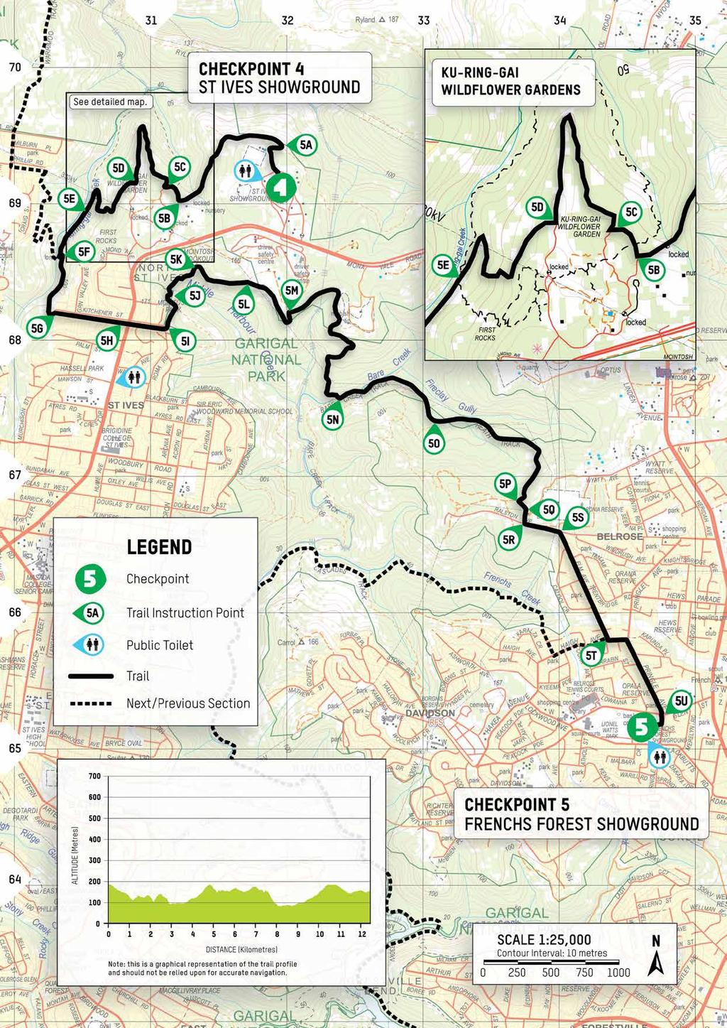
14 100KM ONLY TRAIL SECTION 4 CHECKPOINT BOBBIN HEAD to CHECKPOINT ST IVES SHOWGROUND EVENT DISTANCE SECTION DISTANCE CUMULATIVE DISTANCE CHECKPOINT CLOSING TIME 100km 15.3km 58.1km Checkpoint 4 closes at 2pm Saturday DIFFICULTY RATING: Trail description: 4 After crossing a mangrove boardwalk, the trail follows Gibberagong Track alongside Cockle Creek before a short climb to North Turramurra. Re-entering the national park, the trail passes through the historic Sphinx War Memorial before passing back up through St Ives Chase and entering the spectacular Ku-ring-gai Wildflower Gardens on the way to St Ives Showground. NOTE: Caution is required along Gibbergong Track as it is, at times, slippery, narrow and includes numerous steep drop-offs (refer to Map Ref 4B). Due to locked gate, access is not possible between St Ives Showground and Ku-ring-gai Wildflower Gardens (except during the event). The gates to the Wildflower Gardens are locked at night from 4pm-8am should you wish to leave your vehicles during training walks. During the event, you may experience two-way foot traffic between Map Ref 4Q to Checkpoint 4, where possible stay to the left hand side. Please keep noise to a minimum in residential areas. MAP REF GRID REF CUMULATIVE INSTRUCTION km Depart Checkpoint 3, heading south through the picnic grounds towards the mangrove boardwalk and Gibberagong Track. 4A km Enter Gibberagong Track by crossing the suspension footbridge and continuing along the mangrove boardwalk. 4B km At the junction signposted Wahroonga and Rainforest, turn right towards Wahroonga and continue along Gibberagong Track. 4C km Turn left at the junction with the unnamed track signposted To Murrua Road and ascend the unnamed track towards Murrua Walking Track. 4D km At the top of the climb, turn right at the junction with the fire trail as signposted To Murrua Road and continue south towards Murrua Road. 4E km Exit the fire trail following the path between the metal fence line, passing through the gate onto Murrua Road. Stay on the footpath towards McTaggart Road. 4F km Turn left into McTaggart Road, then shortly after, turn right into Kirkpatrick Street. 4G km Turn right into Du Faur Street and shortly after, turn left onto Bobbin Head Road. Continue on the footpath alongside Bobbin Head Road. 4H km At Leura Crescent, safely cross Bobbin Head Road and continue through the national park entry gates. 4I km Immediately after the toll gates, turn right into the Sphinx War Memorial access road. 4J km Continue through the Sphinx War Memorial, joining the sealed path at the bottom that leads to the Sphinx Fire Trail. Turn right onto Sphinx Fire Trail and then immediately turn left onto Sphinx Walking Track, descending towards the intersection with Warrimoo Track. 4K km Turn right onto Warrimoo Track. 4L km Shortly after entering Warrimoo Track, cross a minor creek via the high water path by staying close to the creek, stepping over the log and down onto the stone boulders. At the far side of the creek, turn left back onto the trail and follow the creek. 4M km Cross Cowan Creek and, at the far side, turn left onto the dirt track and ascend the hill towards Timbarra Road. 4N km Cross Timbarra Road into Warrimoo Avenue and continue towards Phillip Road. 4O km Turn left into Phillip Road. 4P km Enter the fire trail and continue down towards the creek. 4Q km Just after the creek crossing at the junction, bare left onto the fire trail. (Please note, this is the junction of the double back section). 4R km Continue heading north on the fire trail. Do not enter the Muller Track which crosses the Management Trail on both right and left. 4S km The trail turns sharply right and up a steep ascent. Please take care as participants are also heading down during the event. 4T km At intersection turn left onto the sealed cycleway (Solander Trail) and continue towards the junction with Browns Trail. 4U km Turn left into Browns Trail cycleway (also sealed) and continue past the junction with the Muller Track (near signposted Dip sign). 4V km 40 metres past the Muller Track junction, turn left onto an unmarked, pebbly fire trail towards St Ives Showground. Please note there is a locked gate further down the trail (open during the event). 4W km Turn right at the junction marked with a blue arrow and horse sign, and continue left past Princess Anne Equestrian Area km Arrive at Checkpoint 4, on St Ives Showground main arena. Continue onto page 20 for Section 5 trail instructions and map for the 100km distance. Maps produced with permission of Land and Property Information, a division of NSW Department of Finance and Services. New South Wales Government 2013.

15
16 50KM ONLY TRAIL SECTIONS 4 & 5, MAP 1 OF 2 50KM START BOBBIN HEAD to CHECKPOINT EVENT DISTANCE SECTION DISTANCE CUMULATIVE DISTANCE FRENCHS FOREST SHOWGROUND CHECKPOINT CLOSING TIME 50km 20.5km 20.5km Checkpoint 5 closes at 8pm Saturday DIFFICULTY RATING: Trail description: 4 After crossing a mangrove boardwalk, the trail follows the Gibberagong Track alongside Cockle Creek before a short climb to North Turramurra. Re-entering the National Park, the trail passes through the historic Sphinx War Memorial before passing through St Ives Chase rugged bush landscape. NOTE: Caution is required along Gibbergong Track as it is, at times, slippery, narrow and includes numerous steep drop-offs (refer to Map Ref 4B). Please keep noise to a minimum in residential areas. MAP REF GRID REF CUMULATIVE INSTRUCTION km 4A km 4B km 4C km 4D km 4E km Depart the Start, located at Bobbin Head picnic grounds (Apple Tree Bay Rd side), and carefully cross Ku-ring-gai Chase Rd, continuing through the picnic grounds towards the mangrove boardwalk and Gibberagong Track. Enter Gibberagong Track by crossing the suspension footbridge and continuing along the mangrove boardwalk. At the junction signposted Wahroonga and Rainforest, turn right towards Wahroonga and continue along Gibberagong Track. Turn left at the junction with the unnamed track signposted To Murrua Road and ascend the unnamed track towards Murrua Walking Track. At the top of the climb, turn right at the junction with the fire trail as signposted To Murrua Road and continue south towards Murrua Road. Exit the fire trail following the path between the metal fence line, passing through the gate onto Murrua Road. Stay on the footpath towards McTaggart Road. 4F km Turn left into McTaggart Road, then shortly after, turn right into Kirkpatrick Street. 4G km Turn right into Du Faur Street and shortly after, turn left onto Bobbin Head Road. Continue on the footpath alongside Bobbin Head Road. 4H km At Leura Crescent, safely cross Bobbin Head Road and continue through the national park entry gates. 4I km Immediately after the toll gates, turn right into the Sphinx War Memorial access road. 4J km Continue through the Sphinx War Memorial, joining the sealed path at the bottom that leads to the Sphinx Fire Trail. Turn right onto Sphinx Fire Trail and then immediately turn left onto Sphinx Walking Track, descending towards the intersection with Warrimoo Track. 4K km Turn right onto Warrimoo Track. 4L km Shortly after entering Warrimoo Track, cross a minor creek via the high water path by staying close to the creek, stepping over the log and down onto the stone boulders. At the far side of the creek, turn left back onto the trail and follow the creek. 4M km Cross Cowan Creek and, at the far side, turn left onto the dirt track and ascend the hill towards Timbarra Road. 4N km Cross Timbarra Road into Warrimoo Avenue and continue towards Phillip Road. 4O km Turn left into Phillip Road. 4P km Enter the fire trail and continue down towards the creek. 4Q km Just after the creek crossing at the junction, bare right onto the fire trail, leading up to Kitchener St. (Please note, those completing the 100km distance will be turning left at this junction) Continue onto page 18 for continued instructions and map for the 50km distance, starting at 5G. Maps produced with permission of Land and Property Information, a division of NSW Department of Finance and Services. New South Wales Government 2013.

17
18 50KM ONLY TRAIL SECTIONS 4 & 5, MAP 2 OF 2 50KM START BOBBIN HEAD to CHECKPOINT EVENT DISTANCE SECTION DISTANCE CUMULATIVE DISTANCE FRENCHS FOREST SHOWGROUND CHECKPOINT CLOSING TIME 50km 20.5km 20.5km Checkpoint 5 closes at 8pm Saturday DIFFICULTY RATING: 3 Trail description: The trail continues, cutting through North St Ives and into Garigal National Park. After a short decent, cross over Bare Creek and head up Heath Track before entering the suburbs and heading down into Frenchs Forest Showground. NOTE: Keep noise to a minimum in residential areas (particularly Kitchener Street - Map Ref 5I) During the event, you may experience two-way foot traffic between 5U to Checkpoint 5. Where possible stay to the left hand side of the trail. MAP REF GRID REF CUMULATIVE INSTRUCTION 5G km Enter Kitchener Street, heading towards Mona Vale Road. 5H km Cross Mona Vale Road with care via the pedestrian crossing at the traffic lights, and continue down Kitchener St. 5I km 5J km At the bottom of the hill, enter the unnamed fire trail on the left, with a locked gate at the entrance (next to Roma Rd sign), and continue down the trail. After a short descent, turn left at the fire trail intersection. 5K km Turn right onto the dirt road at the intersection. 5L km Turn right at the junction with the road signposted to Pump House and continue past the pump house grounds. 5M km Turn right at the intersecting fire trails and continue through the national park boundary gate onto the Garigal Quarry Track. 5N km At the end of the Garigal Quarry Track (going over Bare Creek), turn left onto the un-signosted Bare Creek Track. 5O km Continue onto Heath Track following the main trail up the hill. 5P km After passing through the locked gate, turn left at the intersection further up the hill. 5Q km Follow the track to the right of the mobile network tower passing the house on your right 5R km At the end of the trail, turn left onto the gravel road. Be aware of traffic. 5S KM At the bitumen turn right onto Elm Avenue. Please stick to the left and keep noise to a minimum. 5T km At the end of Elm Avenue cross Haigh Avenue then head left to Pringle Avenue where you will turn right. Please take extra care when crossing the road. 5U km At the roundabout cross Glen Street and enter the Showgrounds through the wooden fence entry off Glen St km Arrive at Checkpoint 5, at Frenchs Forest Showground oval. Maps produced with permission of Land and Property Information, a division of NSW Department of Finance and Services. New South Wales Government 2013.

19
20 100KM ONLY TRAIL SECTION 5 CHECKPOINT ST IVES SHOWGROUND to CHECKPOINT FRENCHS FOREST SHOWGROUND EVENT DISTANCE SECTION DISTANCE CUMULATIVE DISTANCE CHECKPOINT CLOSING TIME 100km 12.4km 70.5km Checkpoint 5 closes at 8pm Saturday DIFFICULTY RATING: Trail description: 3 After passing through the spectacular Ku-ring-gai Wildflower Gardens, the trail crosses through North St Ives and into Garigal National Park. After a short decent, cross over Bare Creek and head up Heath Track before entering the suburbs and heading down into Frenchs Forest Showground. NOTE: Due to a locked gate, access is not possible between Ku-ring-gai Wildflower Gardens and St Ives Showgrounds (except during event weekend). The gates to the Wildflower Gardens are locked at night from 4pm-8am should you wish to leave your vehicles during training walks. During the event, you may experience two-way foot traffic between Checkpoint 4 and Map Ref 5F and 5U to Checkpoint 5. Where possible stay to the left hand side of the trail. Please keep noise to a minimum in residential areas (particularly Kitchener Street - Map Ref 5I) MAP REF GRID REF CUMULATIVE INSTRUCTION km Depart Checkpoint 4 via the dirt road towards Princess Anne Equestrian Area (PEA), north west of the showgrounds. Enter trail just passed the PEA area. Please note there is a locked gate further down the trail (open during the event). 5A km Turn left onto the fire trail at the junction marked with blue arrow and horse sign. 5B km Turn right onto Browns Trail sealed cycleway. 5C km Turn right onto Solander Trail sealed cycleway. 5D km Turn right onto the fire trail signposted The Management Trail 5E km At the intersection with the Muller Track, turn left and stay on the fire trail. 5F km Turn left at the intersection signposted Wildflower Garden 250m (do not cross the creek), heading towards Kitchener Street. 5G km Enter Kitchener Street, heading towards Mona Vale Road. 5H km Cross Mona Vale Road with care via the pedestrian crossing at the traffic lights, and continue down Kitchener St. 5I km At the bottom of the hill, enter the unnamed fire trail on the left, with a locked gate at the entrance (next to Roma Rd sign), and continue down the trail. 5J km After a short descent, turn left at the fire trail intersection. 5K km Turn right onto the dirt road at the intersection. 5L km Turn right at the junction with the road signposted to Pump House and continue past the pump house grounds. 5M km Turn right at the intersecting fire trails and continue through the national park boundary gate onto the Garigal Quarry Track. 5N km At the end of the Garigal Quarry Track (going over Bare Creek), turn left onto the un-signposted Bare Creek Track. 5O km Continue onto Heath Track following the main trail up the hill. 5P km After passing through the locked gate, turn left at the intersection further up the hill. 5Q km Follow the track to the right of the mobile network tower passing the house on your right 5R km At the end of the trail, turn left onto the gravel road. Be aware of traffic. 5S km At the bitumen turn right onto Elm Avenue. Please stick to the left and keep noise to a minimum. 5T km At the end of Elm Avenue cross Haigh Avenue then head left to Pringle Avenue where you will turn right. Please take extra care when crossing the road. 5U km At the roundabout cross Glen Street and enter the Showgrounds through the wooden fence entry off Glen St km Arrive at Checkpoint 5, at Frenchs Forest Showground oval. Maps produced with permission of Land and Property Information, a division of NSW Department of Finance and Services. New South Wales Government 2013.
21
22 50KM & 100KM TRAIL SECTION 6 CHECKPOINT FRENCHS FOREST SHOWGROUND to CHECKPOINT DAVIDSON PARK EVENT DISTANCE SECTION DISTANCE CUMULATIVE DISTANCE CHECKPOINT CLOSING TIME 100km 11.3km 81.8km Checkpoint 6 closes at 2am Sunday 50km 11.3km 31.8km Checkpoint 6 closes at 2am Sunday DIFFICULTY RATING: 3 Trail description: After passing through Davidson, the trail then becomes rugged and narrow along the valley floor next to Middle Harbour Creek. After crossing the pipeline and Carroll Creek, the single track then stays along the water s edge before opening up to a fire trail just before arriving at Davidson Park picnic area. NOTE: During the event, you may experience two-way foot traffic between Checkpoint 5 to 6C. Please keep to the left side of the path where possible. Keep noise to a minimum in residential areas, upon leaving the checkpoint. The gates to the Davidson Park picnic areas are locked at night from sunset to sunrise by the NSW National Parks & Wildlife Service (except during the event). Check local signage to confirm BEFORE you leave your vehicle during training walks. MAP REF GRID REF CUMULATIVE INSTRUCTION km Exit Checkpoint 5 and walk towards Glen & Pringle St roundabout. 6A km At the roundabout, carefully cross Glen Street and continue down Pringle Ave. 6B km Turn left at Haigh Ave and continue down towards Wanniti Rd, keeping left on the walkway. 6C km Cross Haigh Ave into Wanniti Rd and head to the end, baring left to enter the Frenchs Creek Track. 6D km Turn right at the junction of the Cascades Trail. 6E km Continue straight at The Cascades onto Middle Harbour Creek Track as signposted. Keep left as the trail winds itself around the rock face. (Take extra care on this track as it is, at times, narrow and rugged and can be underwater during king tides. After rain this area can get very soggy). 6F km At the junction, continue straight on Governor Phillip Walk. 6G km At the junction with the concrete service road (Davidson Track) continue along Governor Phillip Walk and walk under the pipeline. 6H km Cross Carroll Creek via a series of stepping stones and turn right into Lyrebird Gully. 6I km At the end of Lyrebird Track cross through the car park turning bay, keeping right, enter the grassed picnic area of Davidson Park. Continue through the parklands and head left just over the small foot bridge km Arrive at Checkpoint 6, Davidson Park picnic grounds Maps produced with permission of Land and Property Information, a division of NSW Department of Finance and Services. New South Wales Government 2013.

23
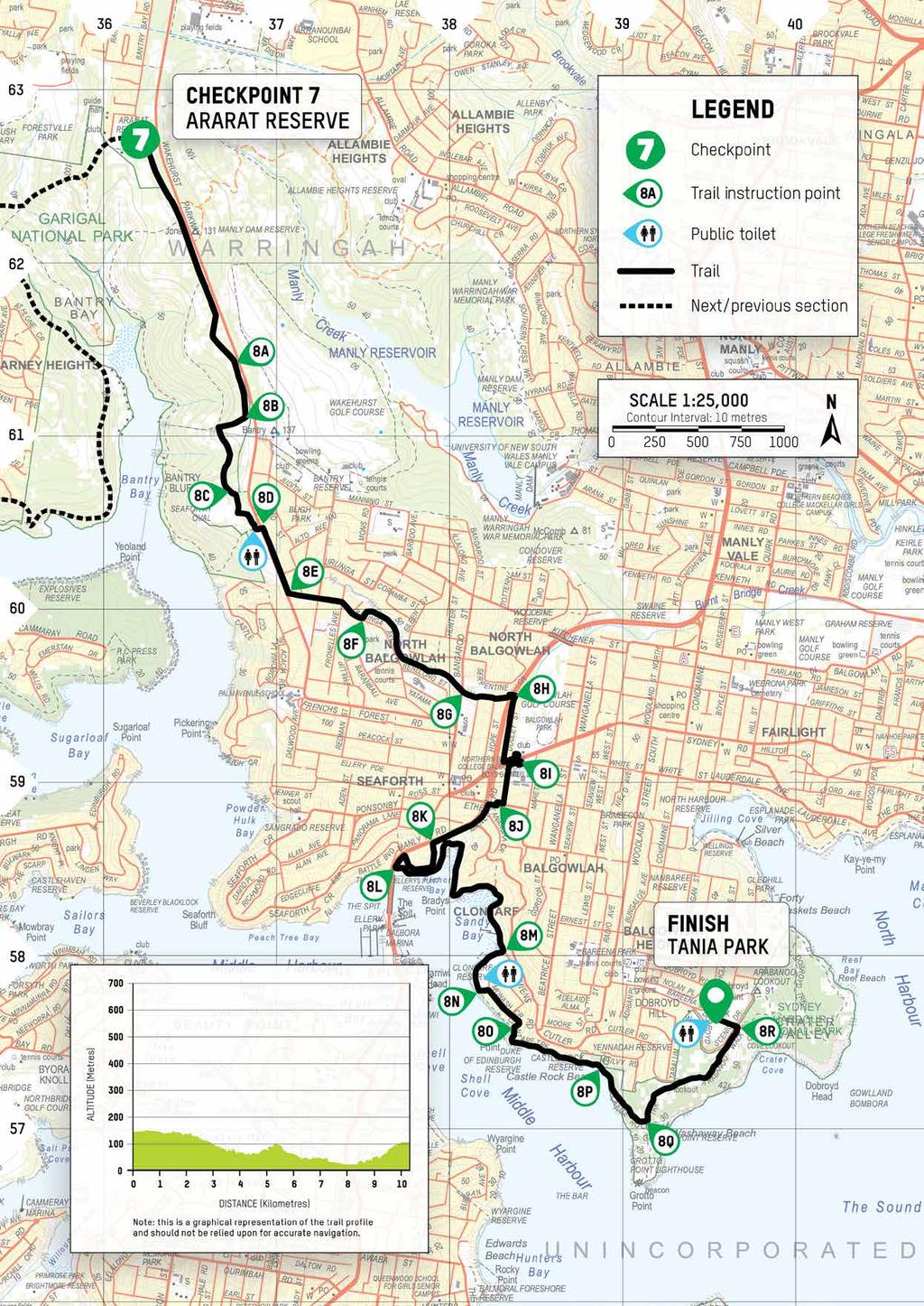
24 50KM & 100KM TRAIL SECTION 7 CHECKPOINT DAVIDSON PARK to CHECKPOINT ARARAT RESERVE EVENT DISTANCE SECTION DISTANCE CUMULATIVE DISTANCE CHECKPOINT CLOSING TIME 100km 7.9km 89.7km Checkpoint 7 closes at 6am Sunday 50km 7.9km 39.7km Checkpoint 7 closes at 6am Sunday DIFFICULTY RATING: 4 Trail description: Travelling alongside Middle Harbour, there is a short urban section before the trail passes the secluded Flat Rock Beach. The trail enters Bantry Bay, behind the Bantry Bay Explosives Magazine Complex. From here, the trail passes through a few tributary creeks, crossing the amazing Natural Bridge and climbing a big rock slab on the way to Ararat Reserve. NOTE: Caution is required along the wire fence line adjacent to the Bantry Bay Explosives Magazine Complex (Map Ref 7G) as some sections of barbed wire remain. Please be aware of mountain bikers in this area. MAP REF GRID REF CUMULATIVE INSTRUCTION km Depart Checkpoint 6 following the river heading south towards Roseville Bridge 7A km Shortly after travelling under Roseville Bridge, make your way to the intersection with the entry road descending down into Davidson Park from Warringah Road. Enter the Flat Rock Track located on the left hand side of the road. 7B km Turn left at the access road and head up the hill to meet Downpatrick Road 7C km 7D km Continue up Downpatrick Road and then turn right into Drumcliff Avenue. Continue right onto Killarney Drive and head to the end. At the end of Killarney Drive head into Flat Rock Track then bare left into the Magazine Track. At the next trail junction turn left continuing down the stairs. Continue to follow Magazine Track towards beach. 7E km Hook left to continue to follow the trail down the stairs. 7F km 7G km 7H km 7I km 7J km 7K km 7L km Take the trail left of the main trail, avoiding stairs down towards Flat Rock Beach. Follow the Magazine Track past the beach. Veer left at the wire fence, following the Magazine Track past the rear of the Bantry Bay Explosives Magazine Complex. Continue straight at the intersection just north of the Bantry Bay Explosives Magazine Complex, and continue on the Magazine Track towards Bates Creek. Continue straight onto Bates Creek Track as signposted at the intersection with the service trail from Tipperary Avenue. Turn right and cross the creek to enter Currie Road Track at the four-way junction with the fire trail from Cook Street and Bates Creek Track. Turn right into the Natural Bridge Track heading towards the Natural Bridge. (Continue straight through Serraton Track). Caution is required as you climb a big rock slab after the Natural Bridge. A hand line will be in place to assist you during the event. Turn left onto The Bluff Track and continue towards Grattan Crescent. Take care as you cross Grattan Crescent to enter Ararat Reserve km Arrive at Checkpoint 7, on the south side of Ararat Reserve. Maps produced with permission of Land and Property Information, a division of NSW Department of Finance and Services. New South Wales Government 2013.

25
26 50KM & 100KM TRAIL SECTION 8 CHECKPOINT ARARAT RESERVE to FINISH TANIA PARK EVENT DISTANCE SECTION DISTANCE CUMULATIVE DISTANCE CHECKPOINT CLOSING TIME 100km 10.3km 100km Finish closes at 10am Sunday 50km 10.3km 50km Finish closes at 10am Sunday DIFFICULTY RATING: Trail description: 3 This final section passes through urban areas, via the beautifully restored Burnt Bridge Creek to the underpass of Burnt Creek Bridge Deviation, before heading down to the Spit Bridge, where the trail follows the stunning views of the Spit to Manly trail to finish up at the scenic Tania Park. NOTE: Please take extra care when crossing roads. Please keep noise to an absolute minimum through urban areas, especially in the evening. MAP REF GRID REF CUMULATIVE INSTRUCTION km Cross Ararat Reserve, heading past the amenities block on your right, then turn right down Bantry Bay Road. Continue onto Engravings Track, past the boundary gate. 8A km Towards the end of Engravings Track, follow the trail into the scrub towards Seaforth Oval. 8B km Turn right at the fork in the trail, away from the Wakehurst Parkway. 8C km 8D km Turn left at the trail junction and continue to Seaforth Oval car park. Use the footpath on the right hand side to make your way towards the carpark exit onto Wakehurst Parkway. Cross Wakehurst Parkway using pedestrian crossing at traffic lights, turn right on footpath alongside Wakehurst Parkway continuing south. 8E km Turn left down Lister Avenue. 8F km 8G km 8H km 8I km 8J km Continue straight of the staggered cross road into Baringa Avenue and enter the Burnt Bridge Creek foot/ bike path signposted Manly. Watch for cyclists. With care, cross Brook Road and continue on shared foot/ bike path. Please be mindful of the residents in this area and keep noise to a minimum. When the path meets the main road (Burnt Bridge Creek Deviation), follow the left loop down to the underpass then immediately follow the left loop up after the underpass. The trail continues uphill and slight left on Dudley Street. At the end of Dudley Street turn left on Sydney Road and cross over the foot bridge. Head back down Sydney Road a short distance and turn left into Coral Street, carefully crossing over to the right side and following the footpath up the street. At the end of the road turn right on Ethel Street, then cross at a safe point. Please take extra care crossing Ethel Street. Turn left into Kanangra Crescent then bare right into foot path adjacent to Manly Road. 8K km Cross Heaton Avenue and continue down the hill, then turn left into Avona Crescent. 8L km Follow Avona Crescent round and turn left into the path shortly before Manly Road (Manly Scenic Walkway). With care, head down the steps into the car park then head left into the Spit to Manly Walk. Follow the trail heading towards Clontarf Reserve. 8M km At Clontarf Reserve, keep right and follow the water s edge around the reserve. 8N km 8O km 8P km As you exit Clontarf Reserve and past the pump house, turn left and take the hightide route. Cross the small green diagonally and bare right on to Monash Crescent. Please be respectful of the residents in this area. At the end of Monash Crescent bare right back towards the beach then turn left towards Manly (Castle Rock Direction) At a T-intersection, head right towards the water for about 20m then head left and continue on the Spit to Manly Walk. 8Q km At the crossroad of the Grotto Point trail continue straight towards Manly. 8R km At the junction near Tania Park continue straight. The trail turns sharply then ascends up steps to Dobroyd Scenic Drive. Please take care when crossing the road. Continue up the steps on to the oval directly opposite the trail exit km Arrive at the Finish, Tania Park Maps produced with permission of Land and Property Information, a division of NSW Department of Finance and Services. New South Wales Government 2013.
27
 8204 3919")


28 SYDNEY Oxfam Trailwalker Sydney Level 3, 25 Cooper Street, Surry Hills NSW 2010 Call: (02) twitter.com/oaustrailwalker facebook.com/oxfamtrailwalkeraustralia instagram.com/oaustrailwalker Cover photo: Michael Myers/OxfamAUS We acknowledge the traditional owners, the Guringai people, of the land on which we walk on and recognise their continuing connection to land, waters and community. We pay our respects to them and their culture and to elders past and present. We welcome Aboriginal people and pay our respects to the people of the Eora Nation, their ancestors, elders and families we share this country with. ABN:
event map book SYDNEY 50KM SYDNEY 100KM
 event map book SYDNEY 50KM SYDNEY 100KM SATURDAY 25 SUNDAY 26 AUGUST 2018 BOBBIN HEAD TO THE HARBOUR FRIDAY 24 SUNDAY 26 AUGUST 2018 THE HAWKESBURY TO THE HARBOUR NATIONAL PARTNERS WWW.OXFAM.ORG.AU/TRAILWALKER
Section 9 - Warringal Parklands, Heidelberg to Fairfield Park, Fairfield
 Section 9 - Warringal Parklands Heidelberg to Fairfield Park Fairfield EVENT DISTANCE SECTION DISTANCE CUMULATIVE DISTANCE CHECKPOINT CLOSING TIME 100KM 11.4KM 100KM The Finish closes at 11.00pm on Saturday
event map book BRISBANE 60KM BRISBANE 100KM
 event map book BRISBANE 60KM BRISBANE 100KM SATURDAY 18 SUNDAY 19 JUNE 2016 LAKE MANCHESTER TO MOUNT COOT-THA FRIDAY 17 SUNDAY 19 JUNE 2016 LAKE MANCHESTER TO MOUNT COOT-THA EVENT SPONSORS WWW.OXFAM.ORG.AU/TRAILWALKER
Mt Kuring-gai Track to Berowra station
 Mt Kuring-gai Track to Berowra station 4 hrs 15 mins 9.7 km One way Hard track 4 553m This walk explores three valleys, with great displays of wild flowers in spring, and some nice sandstone overhangs.
Berowra Waters to Cowan Station
 Berowra Waters to Cowan Station 3 hrs 30 mins 7.2 km One way Hard track 597m This is a hilly walk out of the beautiful Berowra Waters valley to Cowan Station. There are many wide views across Berowra Creek
Merritts Traverse. 1928m
 Merritts Traverse 3 hrs Hard track 5.8 km Circuit 4 167m This walk starts with a scenic journey to the top of the hill on the chairlift. Starting along Merritts Nature walk, this walk soon detours down
Gibberagong Track. 169m
 Gibberagong Track 2 hrs 30 mins 6.5 km One way Hard track 4 180m Starting in suburban Wahroonga, this wellmaintained track follows Cockle Creek down to Bobbin Head in the Ku-ring-gai Chase National Park.
Hiking. Lesson 4.1. Fitness. Hiking
 Lesson 4.1 By Carone Fitness If you enjoy walking, you will probably enjoy hiking. The main difference between hiking and fitness walking is the change in terrain. is typically done in a forest, wilderness,
Crosslands to Cowan. 220m
 Crosslands to Cowan 7 hrs 30 mins 14 km One way Hard track 4 1103m This section of the Great North Walk starts from the Crosslands camping area and winds north alongside Berowra creek, passing through
Jerusalem Bay Track (Cowan to Brooklyn)
") Jerusalem Bay Track (Cowan to Brooklyn) 5 hrs 30 mins 13.4 km One way Hard track 4 654m This Cowan to Brooklyn Station walk is a popular section of the Great North Walk, with scenery ranging from foreshore
Jerusalem Bay Track (Cowan to Brooklyn) 5 hrs 30 mins 13.4 km One way Hard track 4 654m This Cowan to Brooklyn Station walk is a popular section of the Great North Walk, with scenery ranging from foreshore
Berowra to Cowan via Berowra Waters
 Berowra to Cowan via Berowra Waters 6 hrs Hard track 12.9 km One way 4 884m With train station at each end this walk explores the ridges and valleys around Berowra Waters. There are plenty of excellent
Below is an example of a well laid-out template of a route card used by the Sionnach Team which is a good format to begin with.
 Route Card A route card is used as a navigational aid to hill walkers by setting out a step by step plan for an intended hike. It is good practice to make out a route card before every hike you or your
GOLDEN EARS PROVINCIAL PARK
 GOLDEN EARS PROVINCIAL PARK Trail Information as of October 10 th 2015 Do not underestimate the mountainous wilderness of Golden Ears Provincial Park. The combination of rugged terrain and rapidly changing
Staples Lookout to Mt Wondabyne loop
 Staples Lookout to Mt Wondabyne loop 4 hrs 3 mins 1.8 km Circuit Hard track 337m This walk starts and finishes at Staples Lookout, on Woy Woy Rd. The walk follows sections of the Great North Walk around
Leura Cascades to Gordon Falls Reserve
 Leura Cascades to Gordon Falls Reserve 1 hr 15 mins 1.8 km One way Moderate track 200m From Leura Park to Gordon Falls Park, this diverse walk offers fantastic views of the Jamison Valley, as well as two
Nature Track. 900m. 789m. 2 hrs 3.1 km Circuit. Hard track 238m. Blue Mountains National Park
 Nature Track 2 hrs 3.1 km Circuit Hard track 238m Largely following the ridges around the top edge of Wentworth Falls, this track is incredibly beautiful. After taking in the great views at Edinburgh Castle
Crosslands to Brooklyn
 Crosslands to Brooklyn 2 Days Hard track 27.4 km One way 4 1757m From the Crosslands Reserve, this walk heads along the Great North Walk via Berowra Waters, Cowan, Jerusalem Bay and onto Brooklyn. This
Congewai Track Head (East) to Watagan Headquarters
 to Watagan Headquarters") Congewai Track Head (East) to Watagan Headquarters 7 hrs Hard track 17.2 km One way 4 973m This full day walk starts from the Congewai valley trackhead (east) and follows the Great North Walk up into the
Congewai Track Head (East) to Watagan Headquarters 7 hrs Hard track 17.2 km One way 4 973m This full day walk starts from the Congewai valley trackhead (east) and follows the Great North Walk up into the
Difficult Run Stream Valley Park
 Difficult Run Stream Valley Park The more intense mountain bikers have known about for Difficult Run for some time. Equestrians have known it longer. Eight miles of unpaved trail, the Rails to River Trail
Trail Phasing Plan. Note: Trails in the Clear Creek Canyon area (Segments will be finalized in the future to minimize wildlife impacts
 Note: Trails in the Clear Creek Canyon area (Segments 2 5 and a future JCOS connection) will be finalized in the future to minimize wildlife impacts Trail Phasing Plan P Parking 3 Easy Trail Intermediate
Girrakool to Wondabyne station
 Girrakool to Wondabyne station 4 hrs Hard track 9.5 km One way 4 438m This walk starts from the Girrakool picnic area and winds south, through the Brisbane Waters National Park. The walk crosses some long
Victoria Falls Lookout to Blue Gum Forest
 Victoria Falls Lookout to Blue Gum Forest 8 hrs Experienced only 13.8 km One way 5 112m This long day-walk follows a remote track down from Victoria Falls lookout, passing the waterfall, and into the Grose
Leaden Boot Challenge ROUTE INSTRUCTIONS
 Leaden Boot Challenge ROUTE INSTRUCTIONS Section 1 Alstonefield to Ilam From the village hall car park turn R then L and pass through the village keeping to the R to enter Church Street. Pass the Church
Berowra to Hornsby. 9 hrs 18 mins 22.6 km One way. Hard track. 1423m
 Berowra to Hornsby 9 hrs 18 mins 22.6 km One way Hard track 4 1423m One of the longer day walks in Berowra Valley National Park, this walk mostly follows Berowra Creek along the Great North Walk. Excellent
Wentworth Pass. 893m. 535m. 4 hrs. Hard track 5.1 km Circuit. 692m
 Wentworth Pass 4 hrs Hard track 5.1 km Circuit 4 692m This walk offers a great way to explore the magical, upper section of the Valley of the Waters. The walk starts and finishes at Conservation Hut, which
Walking and Hiking in Tirol
 Walking and Hiking in Tirol Emergency app Tirolean Mountain Rescue Service There is a lot to learn about mountain climbing and that takes time! Just like skiing, initial climbing experiences should be
Victoria Falls and Grose Valley to Blackheath Station
 This walk explores a fantastic section of the Grose Valley. Starting above Victoria Falls, the walk explores the cascades before dropping into the valley for the first nights rest at Burra Korain campsite.
Trail First Aid Advice for Advisors John Blackwell
 Trail First Aid Advice for Advisors John Blackwell NCAC High Adventure Committee Philmont Training III - March 11, 2016 Trail First Aid Advice for Advisors Wilderness First Aid Context Crew Advisor s Role
Erskine Creek via Pisgah Rock and Jack Evans
 Erskine Creek via Pisgah Rock and Jack Evans 4 hrs 30 mins 7.1 km Circuit Very experienced only 6 421m This walk visits some great lookouts and explores the lower section of Erskine Creek. Most of the
Premium Waterfront Land for Sale
 Premium Waterfront Land for Sale An opportunity has arisen for the astute investor to purchase one of the last remaining blocks of absolute waterfront land at Berowra Waters. Lot 3 Coba point features
Patonga to Wondabyne station via Mt Wondabyne
 Patonga to Wondabyne station via Mt Wondabyne 7 hrs 3 mins 19.5 km One way Hard track 4 861m This walk explores some grand views, pleasant cascades, varied bushland and remote areas of Brisbane Waters
Guthega to Mt Twynam. 2183m. 1583m. 6 hrs 45 mins 14.8 km Return. Experienced only. 913m
 Guthega to Mt Twynam 6 hrs 45 mins 14.8 km Return Experienced only 5 913m This walk starts from Guthega and makes its way along the Snowy River to the Illawong Lodge, via the Blue Cow Creek flying fox.
Leaden Boot Challenge 2016 ROUTE INSTRUCTIONS
 Leaden Boot Challenge 2016 ROUTE INSTRUCTIONS Section 1 Alstonefield to Ilam (CP2) From the village hall car park turn R then L and pass through the village keeping to the R to enter Church Street. Pass
Crosslands to Berowra Waters return
 Crosslands to Berowra Waters return 6 hrs Hard track 13.7 km Return 4 1005m This return walk starts from the Crosslands Reserve and follows the Great North Walk along Berowra creek. The walk includes some
National Pass. 893m. 665m. 3 hrs 30 mins 4.6 km Circuit. Hard track 773m. Blue Mountains National Park
 National Pass 3 hrs 3 mins 4.6 km Circuit Hard track 773m 4 This walk offers fantastic views of the Jamison Valley and the surrounding cliffs. Take time to explore the historic and very scenic ledge halfway
Patonga to Staples Lookout
 Patonga to Staples Lookout 6 hrs 3 mins 17 km One way Hard track 4 72m This great walk explores much of the main ridge ridge running through Brisbane Water National Park. The walk visits a number of great
Backpacking Honour Booklet
 Backpacking Honour Booklet Name: Church: Club: Class Due Date: In order to successfully complete this honour, you must: 1. Satisfactorily complete this Booklet. The pass mark is 75%. The number of marks
The Queen Stage. 100, 200 & 300 Audax Rides - Saturday 22 nd July 2017
 The Queen Stage 100, 200 & 300 Audax Rides - Saturday 22 nd July 2017 A challenging course including most of the big climbs through Northern Sydney before heading north towards Yarramalong and returning
Basic Bushwalking Skills Certificate. Assessment Package
 Basic Bushwalking Skills Certificate Assessment Package Basic Bushwalking Skills Aligning with National Outdoor Recreation Modules E:\Contract Work\Andrew Govan\Bushwalking Leadership\2015-09-11 Basic
Manly to Austlink servicing Balgowlah, Seaforth, Northern Beaches Hospital, Frenchs Forest, Glenrose Village Shopping Centre & Belrose
 Manly to Austlink servicing Balgowlah, Seaforth, Northern Beaches Hospital, Frenchs Forest, Glenrose Village Shopping Centre & Belrose How to use this timetable This timetable provides a snap shot of service
Illawarra Escarpment State Conservation Area Walking Tracks
 Illawarra Escarpment State Conservation Area Walking Tracks NPWS Illawarra Area Office Ground Floor, Government Office Block 84 Crown Street Wollongong NSW 2500 02 4223 3000 (Mon-Fri) Royal National Park
Sponsored by. statestreet.com
 /STATESTREETISLANDWALK #ISLANDWALKJSY Sponsored by statestreet.com Important Information If you forget everything else PLEASE remember the following.» Remember to check OUT of every checkpoint» If you
Scenic Railway to Ruined Castle
 Scenic Railway to Ruined Castle 7 hrs 30 mins 12.4 km Return Hard track 4 963m This is a very popular, full day walk, in the Katoomba Area, offering great views of the valley. The walk follows the edge
Hornsby station to Crosslands
 Hornsby station to Crosslands 6 hrs 45 mins 16.1 km One way Hard track 4 938m This section of the Great North Walk starts from Hornsby train station and winds down along the Blue Gum Walk into Fishponds.
Hiking Las Vegas.com
 Hike: Mt. Wilson via First Creek Canyon route Trailhead: First Creek marked Distance: 10 miles up and back Elevation gain: 3,400 feet Elevation of Peak: 7,070 feet Time: 7 to 9 hours (up and back) Difficulty:
Self-Guided Walk Langdale Pikes. Start & Finish: NT car park (free to members) at Sticklebarn - on the right just beyond the New Dungeon Ghyll hotel.
 at Sticklebarn - on the right just beyond the New Dungeon Ghyll hotel.") Self-Guided Walk Langdale Pikes Key Information These mountains form a collection of spires and cliffs on the north side of Langdale. This walk visits four of the main tops Pavey Ark, Harrison Stickle,
Self-Guided Walk Langdale Pikes Key Information These mountains form a collection of spires and cliffs on the north side of Langdale. This walk visits four of the main tops Pavey Ark, Harrison Stickle,
BUDGET GROUP ACCOMMODATION 2018
 PITTWATER YHA BUDGET GROUP ACCOMMODATION 2018 Located within Kur-ring-gai Chase National Park, overlooking Morning Bay on Pittwater s western shore, this property offers exclusive use accommodation for
Other Agencies and Organizations
 Daniel Boone National Forest 1700 Bypass Road WInchester, KY 40391 859-745-3100 Location Northern terminus is near Morehead, Kentucky. Southern terminus is located in the Big South Fork NRRA in Tennessee.
Cowan to Wondabyne station via Patonga rest area
 Cowan to Wondabyne station via Patonga rest area 2 Days Hard track 33.4 km One way 4 1523m This section of the Great North Walk starts from Cowan train station and wanders past the majestic Jerusalem Bay
Tumbler Ridge Global Geopark
 Tumbler Ridge Global Geopark WILDERNESS WATERFALLS These waterfalls are in remote locations, no trails exist, and GPS is required. Not every geosite needs a hiking trail. Providing ready access to all
Risk Assessment. This risk assessment is fully reviewed on and annual basis. Amendments and additions are incorporated as required.
 KICC is a camping and activity centre located in Kingsdown, Nr Deal, Kent. Set in 40 acres of sloping open grassland the estate enjoys woodland boundaries and unparalleled sea views across the English
Carnarvon Station Reserve, Qld Camping Information
 Carnarvon Station Reserve. Photo: Katrina Blake Carnarvon Station Reserve, Qld Camping Information Quick facts Acquired: 2001 Area: 59,000 ha Traditional owners: Bidjara Location: Central Highlands region,
TOUR MANAGEMENT HANDBOOK CAMPSITE. Tour Management Handbook - Campsite
 TOUR MANAGEMENT HANDBOOK CAMPSITE Tour Management Handbook - Campsite CONTENTS 1. Introduction 2 2. Camp Fires 3 3. Weather: Cold & Wet Conditions 4 4. Weather: Hot & Sunny Conditions 5 5. Hygiene 6 6.
Geocaching Activity Plan
 Geocaching Activity Plan CONTENTS Outcomes... 2 Activity... 2 2.1 Outline... 2 2.2 Equipment... 2 2.3 Communication... 3 2.4 First Aid... 3 People... 3 3.1 Activity Instructor... 3 3.2 School Staff Member
Survivor (Lake Version) Activity Plan
 Activity Plan") Survivor (Lake Version) Activity Plan CONTENTS Outcomes... 2 Activity... 2 2.1 Outline... 2 2.2 Equipment... 3 2.3 Communication... 3 2.4 First Aid... 3 People... 4 3.1 Activity Instructor... 4 3.2 School
Survivor (Lake Version) Activity Plan CONTENTS Outcomes... 2 Activity... 2 2.1 Outline... 2 2.2 Equipment... 3 2.3 Communication... 3 2.4 First Aid... 3 People... 4 3.1 Activity Instructor... 4 3.2 School
Skiing and Snowshoes on Un-groomed Fernan Saddle Terrain
 Skiing and Snowshoes on Un-groomed Fernan Saddle Terrain Three ski or snowshoe routes are available from the Fernan Saddle Parking Lot which either do not cover routes ordinarily groomed for snow machine
Overnight Hike Activity Plan
 Overnight Hike Activity Plan CONTENTS Outcomes... 2 Activity... 2 2.1 Outline... 2 2.2 Equipment... 2 2.3 Communication... 3 2.4 First Aid... 3 People... 3 3.1 Activity Instructor... 3 3.2 School Staff
Logo Department Name Agency Organization Organization Address Information 5700 North Sabino Canyon Road
 Logo Department Name Agency Organization Organization Address Information United States Forest Coronado National Forest 5700 North Sabino Canyon Road Department of Service Santa Catalina Ranger District
Saturday Hike - Hancock Loop & Out
 AMC August 3, 2015 Saturday Hike - Hancock Loop & Out 0 2487 ft 2007, Appalachian Mountain Club. All rights reserved. Notes Created by AMC White Mountain Guide Online wmgonline.org 1 Distance Time Elev
Dadder Cave and Jack Evans track
 Dadder Cave and Jack Evans track 2 Days 10.3 km Circuit Very experienced only 535m This fairly short overnight walk is a great way to explore Erskine Creek. The walking along Erskine creek is mostly off
Tiger Mountain State Forest:
 98 60 hikes within 60 miles: SEATTLE 20 Tiger Mountain State Forest: West Tiger Mountain Three Loop i KEY AT-A-GLANCE INFORMATION Length: 5.1 miles round-trip Configuration: Loop Difficulty: Moderate difficult
Stephens State Park Trails
 TRAILS OF ALLAMUCHY MOUNTAIN & STEPHENS STATE PARKS Allamuchy Mountain and Stephens State Parks contain 28 marked trails providing access to diverse landscapes for walking, hiking, biking, bird-watching,
Great Ocean Road Two Day Tour
 www.greatoceanroad.vc Great Ocean Road Two Day Tour This two day trip of approximately 530 kilometre starts from Melbourne and provides a good overview of features along the Great Ocean Road between Anglesea
COLOUR G U I D E. Sydney to Newcastle: Australia s most accessible long-distance walk
 COLOUR G U I D E Sydney to Newcastle: Australia s most accessible long-distance walk Woodslane Press Pty Ltd Unit 7/5 Vuko Place Warriewood, NSW 2102 Australia Email: info@woodslane.com.au Tel: (02)
Abbotts Falls Walking Track
 Abbotts Falls Walking Track 3 hrs 7.3 km Circuit Hard track 329m This circuit takes you through both dry and moist forest, using a combination of walking trails and wider tracks. The side trip to the dammed
Witte Museum Tour Painted Shelter on the Rio Grande River Saturday June 2, :30 A.M. 3:00 P.M.
 Witte Museum Tour Painted Shelter on the Rio Grande River Saturday June 2, 2018 9:30 A.M. 3:00 P.M. This tour is limited to 35 participants (Ages 12 and up) All minors must be accompanied by a parent or
Blackheath to Blue Gum loop
 Blackheath to Blue Gum loop 2 Days Hard track 24.1 km Circuit 4 1335m This walk is great for fit people getting into overnight walking, with its fantastic scenery and nostalgia as a classic overnighter.
The Mendip Way. Route Directions and Maps Uphill to Wells
 The Mendip Way Route Directions and Maps Uphill to Wells Website: www.mendiphillsaonb.org.uk Email: mendip@mendiphillsaonb.org.uk Facebook & Twitter: @MendipHillsAONB Phone: 01761462338 1 Uphill to Loxton
Somersby to Yarramalong via Stringy Bark Point
 Somersby to Yarramalong via Stringy Bark Point 2 Days Hard track 26.7 km One way 4 1201m This section of the Great North Walk starts form the Somersby General Store and follows the Great North Walk north
7. OMG WHAT DO I WEAR? COASTREK PLAN & TRAIN E-BOOK BY WILD WOMEN ON TOP
 OMG WHAT DO I WEAR? 7. OMG WHAT DO I WEAR? COASTREK PLAN & TRAIN E-BOOK BY WILD WOMEN ON TOP 2 The good news is, here is a gear list! The bad news is, there is no such thing as the perfect gear list 3
CWMGIEDD FROM ABERCRAVE
 Abercrave to Cwmgiedd Walk Page 1 Starting from The Abercrave Inn. Grid Ref: SN 824128 From the Abercrave Inn, an 11.3km (7 miles) walk to the foothills of the Cribarth Mountain, then through forest to
Wondabyne station to Somersby Store
 Wondabyne station to Somersby Store 10 hrs Hard track 26.2 km One way 4 1164m This walk, following a section of the Great North Walk, starts from the Wondabyne train station and winds north, into the Brisbane
EMERGENCY MEDICAL RESPONSE
 First Aid EMERGENCY MEDICAL RESPONSE Should an injury occur that requires an ambulance to transport an injured employee to a physician or hospital, the below listed actions will be taken in order given:
Cambridge Folk Festival
 Cambridge Folk Festival 28 31 July 2016 Cherry Hinton Hall Grounds Promoted by Cambridge Live Information Sheet for Disabled People 1 General Information The Festival takes place outdoors within 36 acres
Girrakool to Wondabyne station via Pindar caves
 Girrakool to Wondabyne station via Pindar caves 7 hrs 30 mins 18.1 km One way Experienced only 5 741m This walk starts from the Girrakool picnic area and winds south, following Piles creek into the Brisbane
Witte Museum Tour Meyers Spring Ranch Tour Saturday, September 1, a.m. - 4 p.m.
 Witte Museum Tour Meyers Spring Ranch Tour Saturday, September 1, 2018 10 a.m. - 4 p.m. This tour is limited to 35 participants (Ages 12 and up) All minors must be accompanied by a parent or legal guardian.
Bibbulmun Track. Cape to Cape Track. Two of the world s great long distance walking tracks. 973 km. 135 km km Off-road cycle touring
 Trail revitalising Western Australia Bibbulmun Track 973 km Cape to Cape Track 135 km Two of the world s great long distance walking tracks 1062 km Off-road cycle touring Trail revitalising 1. Framework
Northern Beaches Transport Action Plan
 Northern Beaches Transport Action Plan The NSW Government is taking action now to deliver transport improvements for the Northern Beaches, as well as planning for the future growth of the area. $633 million
Snowmobile Safety Tips
 Snowmobile Safety Tips The winter weather is bringing out snowmobilers, and safety officials are urging them to be careful. More than 200,000 registered snowmobiles hit Wisconsin s 25,000 miles of groomed
MudCrew : The Roseland August Trail (RAT) : 2019 EVENT GUIDE
 : 2019 EVENT GUIDE") MudCrew : The Roseland August Trail (RAT) : 2019 EVENT GUIDE MudCrew presents: The Roseland August Trail (RAT) Series 2019 Thank you for interest in the 2019 Roseland August Trail (RAT) Race Series. The
MudCrew : The Roseland August Trail (RAT) : 2019 EVENT GUIDE MudCrew presents: The Roseland August Trail (RAT) Series 2019 Thank you for interest in the 2019 Roseland August Trail (RAT) Race Series. The
PAGE OF CONTENTS PAGE 3
 PAGE OF CONTENTS Pre Departure... 4 Travel Documentation... 5 Travel Fatigue & Planning Ahead... 6 Driving the Campervan... 7 Driving at Night... 8 Bushwalking... 9 Swimming... 10 Fire Restrictions...
Road Signs, Markings and Their Meaning
 Road Signs, Markings and Their Meaning FUNCTIONS OF ROAD SIGNS AND MARKINGS 1. Guides 2. Directs 3. Warns 4. Informs 5. Prohibits 6. Regulates CLASSIFICATION OF ROAD SIGNS 1. Warning 2. Regulatory 3. Informatory
BELIEVE ACHIEVE INSPIRE
 TRIP NOTES BELIEVE ACHIEVE INSPIRE DORSET 3 PEAKS CHALLENGE UK Sat 29 Sep Sat 29 Sep 2018 OVERVIEW DORSET 3 PEAKS CHALLENGE UK 2 In aid of Diverse Abilities 29 Sep 29 Sep 2018 1 DAYS UK CHALLENGING Join
2019 DAY HIKE AT IRON MOUNTAIN SATURDAY, JANUARY 19
 WHERE? In Google Maps, paste the following coordinates for Iron Mountain: 32.978215,-116.972593 or CLICK ON THIS LINK. I. Purpose of the Day Hike A. THE WBC Day Hike is a relatively short trail hike to
Split Point Lighthouse Aires Inlet
 www.greatoceanroad.vc Great Ocean Road Three Day Tour 2 Night Stay This three day trip of approximately 730 kilometre starts from Melbourne and provides a good overview of features along the Great Ocean
Suggested Day Hikes. Mount Greylock State Reservation 3, 4 1, 2. Take a Hike! Things to remember:
 Suggested Day Hikes Mount Greylock State Reservation Take a Hike! This guide offers suggested day hike routes in two parts: 1) Year-round Hikes and 2) Seasonal Hikes (late-may to Nov.1). Use this guide
Main Range Walk - Charlotte Pass to Mount Kosciuszko
 Main Range Walk - Charlotte Pass to Mount Kosciuszko 9 hrs Hard track 21.9 km Circuit 4 920m This full day walk explores some of the greatest alpine country on offer in NSW. The walk grants views of Blue,
All persons have a duty to do all they can to avoid harm to themselves or others.
 This risk assessment is designed to highlight some of the potential hazards involved in a trip to Morocco, how Discover Ltd has attempted to reduce these risks and how individuals can reduce the risk to
Survey Summary. 1. Overview. Pilot Implementation Survey Toronto Parks & Trails Wayfinding Strategy (Phase II) September 30 November 6, 2017
 September 30 November 6, 2017") Survey Summary Pilot Implementation Survey Toronto Parks & Trails Wayfinding Strategy (Phase II) September 30 November 6, 2017 1. Overview Between September 30 and November 6, 2017, the City of Toronto
Survey Summary Pilot Implementation Survey Toronto Parks & Trails Wayfinding Strategy (Phase II) September 30 November 6, 2017 1. Overview Between September 30 and November 6, 2017, the City of Toronto
Mind Hike, The Lakes September 2017
 I made new, life-long friends and smashed what I thought were my own personal limits. Mind Hike, The Lakes September 2017 Registration fee: 85 Minimum sponsorship 675 www.mind.org.uk/hike2017 Reg. Charity
beach. Make the ford and follow the trail out to the junction with Red Creek Tr in an open grassy area.
 Description: This is a moderate to slightly strenuous 22.8 mile backpack (add 2.6 miles if you do the packless out and back to the Lion s Head) that will have you exploring nearly every thing that is The
The Witte Museum Rock Art Foundation White Shaman Preserve Guided Tours
 The Witte Museum Rock Art Foundation White Shaman Preserve Guided Tours Every Saturday, September through May These tours are limited to 20 participants (ages 12 and up) All minors must be accompanied
HOW TO SURVIVE WHEN LOST IN THE DESERT
 HOW TO SURVIVE WHEN LOST IN THE DESERT Do not panic, especially if people know where you are and when you are scheduled to return. If you have a vehicle, stay with it do not wander! If you are on foot,
Our Murray River Beaches
 Page 1 of 5 Our Murray River Beaches Click here to print this page West of Yarrawonga are many access points to the river. Earth tracks lead from the Murray Valley Highway through state forests to picnic
TriPyramids via Slide Trails
 AMC August 12, 2010 TriPyramids via Slide Trails 0 2999 ft 2007, Appalachian Mountain Club. All rights reserved. Notes Created by AMC White Mountain Guide Online wmgonline.org 1 Distance Time Elev Change
The Mountains are for Everyone. Hillwalking Adventure Skill General Guidance Stages 1 to 9
 The Mountains are for Everyone Hillwalking Adventure Skill General Guidance Stages 1 to 9 Hill Walking Adventure Skills Key Elements Part of the Larger ONE programme roll out A 9 Stage Scheme from first
Cambridge Folk Festival. Information Sheet for Disabled People
 Cambridge Folk Festival 27 30 July 2017 Cherry Hinton Hall Grounds Promoted by Cambridge Live Information Sheet for Disabled People 1 General Information The Festival takes place outdoors within 36 acres
Victoria Falls to Blackheath Station
 Victoria Falls to Blackheath Station 2 Days Experienced only 22.2 km One way 5 1561m This is a fantastic overnight walk with a sleep in Acacia Flats camping area. The Grose Valley, with its views of the
Atlas Mountains Expedition - Information Sheet
 Atlas Mountains Expedition - Information Sheet Thank you for enquiring about our upcoming Atlas Mountains Expedition. Hopefully this document will provide you with sufficient detail about the trip and
Victoria Falls and Grose Valley to Blackheath Station
 Victoria Falls and Grose Valley to Blackheath Station 3 Days Experienced only 22.5 km One way 5 158m This walk explores a fantastic section of the Grose Valley. Starting above Victoria Falls, the walk