Roads Main trails on this map include; to download this map or Map 1 and track notes
|
|
|
- Norman Chapman
- 5 years ago
- Views:
Transcription


 Best of both worlds Ride the")


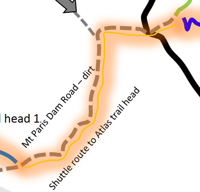

1 MAD times with Bus2Berms.net.au shuttles Derby & Blue Tier Tier Mountain Mountain Bike Trails Trails, ails, Bush Tracks & Access Roads Roads Main trails on this map include; to download this map or Map 1 and track notes New single track all intermediate rated 40 km Blue Derby Epic Trail Blue Tier > Weldborough 18 km (includes Big Chook) Weldborough > Atlas trail head 6 km Atlas > Dam Busters 8 km Dam Busters > Devilwolf 2 km Devilwolf > Derby 2 km Or Devilwolf > Long Shadows > Return to Sender Tasman Highway Mobile Derby to Blue Tier $55 Weldborough to Atlas $10 Derby to Atlas $25 Merida ebike Hire 32 Main St Derby Atlas Big Chook Loop (Can ride up Emu Rd (dirt) from Weldborough 4 km and 5 km down Big Chook! Little Chook loop Moorina Map 2 of 2 Ringarooma River Track Derby stacked loop trails - See Map 1 Cemetery Golf club Old School Trails all intermediate rated and include; Blue Tier Descent (about 10 km, depending on start route) OC Track - 8 km Mutual Road Descent 7 km to Mutual Rd and another 8 km to Derby (starting at Atlas trail head) Best of both worlds Ride the first 6.4 km of the new Blue Tier trail (from under the timber gateway) and exit over the back of the left hand berm. A 20 metre hike a bike gets you on the old school Blue Tier Descent (turn left onto trail). Rocks slabs, bouldering, river crossing follow then onto the 4wd track and finish with a full Big Chook. Can life get any better than this? Derby Start of OC track multi purpose Krushka s Branxholm 6.4 km from start of new Blue Tier gateway you can jump onto the best section of old school Blue Tier Descent shuttle point to trail head Black Stump Follow signs from here to ride up to top of Atlas Blue Tier Trail Blue Tier Trail shuttle point to Atlas Trail Head 1 Weldborough Atlas trail head 1 shuttle point Weldborough & Big Chook or pick up for Atlas and Blue Tier Sign on Mt Paris Dam Rd shuttle point to the 40 Km Blue Derby Epic Trail or TM Blue Tier Descent
2

3 Basic Trail Info for Derby & Blue Tier The trails around Derby are a stacked loop design and are ridden in a single direction ONLY. Note direction of arrows. Take plenty of water / food with you, especially if riding up to Atlas or Dam Busters. Do not drink from creeks! Not toilets on trails either! Mobile Telstra patchy. No other providers have coverage in this valley! For the kids & beginners (green trails) Fitness level required not much 3 trails only sorry! River trail - from the showers (primary trail head) to the secondary trail head and shuttle depart point for Atlas. Chain Gang This trail is wheel chair friendly and flows around the mining works around the Cascade River s edge. Great easy trail. Rusty Crusty This is a third option but please be careful as there are some rough rocky creek crossings and the odd rough section. Kids / beginners may need to walk these. The rest of the trail rides like Chain Gang and well worth it. This trail is the main trail into the trail network and thus links onto Saw Tooth. Experienced beginner to intermediate riders Axe Head This is the main trail that takes you up to all the other trails in the Derby network. This is a great ride that takes you through along the lower reaches of the Cascade River and through the twisties. Be sure to grab a photo at Trout Falls before heading up to Devil Wolf. Devil Wolf This rocky canyon is a must stop and is reached after crossing a small green bridge and rock pathway. More often than not, you miss this until you ride Long Shadows & Flickity Sticks. Devil Wolf is the centre of most of the trails in this area. From here you can ride; 1. Up Long Shadows & down Flickity Sticks 2. Up Long Shadows, Long Shadows Upper From this you can ride; Return to Sender, Long Shadows Upper & Lower, Shearpin & 23 Stitches, Dentonate or onto Dam Busters or Atlas (via Carnac Rd) 3. Dam Busters (via Long Shadows & 1/3 Flickity Sticks and along The Great Race and up Heart Break Hill) 4. Krushka s 5. Trouty (via Krushka s) 6. Rattler 7. Boulder Falls 8. or back to Derby via Relics & Saw Tooth 9. You can ride up to the Atlas, via Dam Busters (up route), then follow the signs. Long Shadows (5 15 minutes) up Long Shadows is a gentle climbing ride on an easy trail. Basic fitness is required, with basic bike skills. It follows a few water races, which were used to direct water to Derby s tin mines, many years ago, as it winds its way up to Flickity Sticks.
4 Long Shadows Upper (5-15 minutes) up Long Shadows upper takes you to the new shuttle point at the top of Casacade Dam Rd. The trail uses switchbacks to assist in the required elevation gain. A nice ride that requires a bit of effort & fitness. The payoff is worth it, with a choice of 3 trails at the top. Flickity Sticks Upper & Lower, Return to Sender (takes you back to Derby), Shearpin / 23 Stiches or onto Dam Busters / Atlas. Flickity Sticks Upper (3-8 minutes) down This is an awesome extension of Flickity Sticks lower and well worth the extra climbing. With heaps of huge berms, roll overs and features, this light blue trails suits the advance beginner on. Flickity Sticks (5-8 minutes) down Flickity Sticks is a great descending ride, with a selection of berms to get you ready for the other trails in the area. It is the easiest of the blue trails in the network and well worth your effort. Note If you find Flickity Sticks difficult, do not try the others and make your way back to Derby via Relics & Saw Tooth Boulder Falls (5 10 minutes) Easy except for crossing at falls Relics (5 minutes) Easy. Suit experienced beginner Relics is a return trail from the junction at Long Shadows & Flickity Sticks. It basically follows the old road back to where Rattler trails joins Saw Tooth. Saw Tooth (10 20 minutes) Easy. Suit experienced beginner Saw Tooth is the return trail back to Derby from Devil Wolf. It has a few minor technical points along the way, but these can be walked if need be. You can side track to Monument, which needs to be ridden with care, as some sections go past 3 metre drops. The monument gives you a view over the township of Derby. Blue Derby Trail (Blue Tier Section) This trail start at the top of the Blue Tier at Piomenia, This trail is a 50 to 90 minutes (18 km) light blue ride with a few technical features. It transverses sub alpine terrain, with great views across north east Tasmania (on a sunny day!) It goes through Myrtle forests and along creels and stream, similar those found in in Cradle Mountain National Park. It has a very gentle sloping gradient, with the odd switchback and creek crossing. The trail builders have gone for back country experience over excitement and adrenaline in this trail. Intermediate Riders Dam Busters (1 2 hours) Good level of bike skills required (for the descent into Devil Wolf fitness and) This ride requires a bit of effort to get to the main trail. From Devil Wolf you head up Long Shadows > then go down 1/3 of Flickity Sticks and turn right onto the Dam Busters Trail. You ll travel up along Heart Break Hill before descending down onto Cascade Dam Rd. You ll then follow this 4wd tack until one again hitting some magic single track. Be sure to look up and around as you ride along this bit of trail. When you hit the old logging bridge with the new bit over the top, stop here for a refueling stop, as the fun now begins or at the lakeside Stop, 5 minutes further on. Dam Busters finishes at Devil Wolf. This is the rock canyon you see in many photos. From here, you can ride Krushka s or Long Shadows > Flickity Sticks or head back to Derby either via right (Boulder Falls) or left & cross over green bridge and head off right down Relics, cross the creek and left into Saw Tooth onto Derby. Ride Option 2 - This is a quicker and easier UP option, or so we believe, as it takes out Heartbreak Hill. Ride up Cascade Dam Rd (which starts of Krushka s St (see Derby Town Hall). A tarmac rd soon turns to dirt and is a steady climb. You ll soon pass a Blue Derby trail signpost, where Long Shadows pops onto the road. Continue up Cascade Dam Rd and head straight ahead when the road goes right. Just after this, you ll see the trail post for Flickity Sticks. Continue up Cascade Dam Rd, as it climbs for another few km. Then it s down to the lake. Turn right head (Dam Busters trail from Heartbreak Hill comes in from the right here. You are now on the old road that will take you to Dam Busters & Atlas trails. Return to Sender (10 20 minutes) along & down, down, down. A great ride back to Derby, following some former mining water races at first. Then you start to descend, passing some great natural features, huge berms and lots of flow. After a bit of climbing, a rest on a bench and lots of ferns, you enter the flow zone, descending into Derby, with 1 metre gap jumps (B lines available) and HUGE berms, you d lose cows in. With a rock slab finish you be spat out in the middle of Derby, opposite the Derby Post Office. Ie. You have just been Returned to Sender! Shearpin (5-10 minutes) down a selection of techy rock slab descents and crossing with a few purpose built timber bridges to help you along. This little warm up gets you ready for 23 Stitches, with a few HUGE berms, 1 metre gap jumps and a nice little techy rock sections to end you up at the bottom of Flickity Sticks. You ll want more after that little effort. Krushka s (45 90 minutes) - Good level of bike skills & fitness required for both the climb up and descent. Intermediate beginner could attempt this, with car & fitness. This is a great ride, especially if you like to put in a bit of effort before your reward. A typical cross country type of ride with descending berms you can lose cows in. It has a few technical sections for the advance beginner, if you have the fitness, both when climbing & descending. It takes through a variety of forest types, so be sure to look around as you ride through. Climb up from Devil Wolf takes between minutes, depending on fitness. Rattler (10 15 minutes) Rattler is normally done as part of Krushka s and requires the same level of skills and fitness.
5 Howler (5 10 minutes) takes you past Boulder Falls. Advanced Beginner could ride this. Just be careful of rock features. You may be best to walk these. Atlas (30-60 minutes one way) - a good level of bike skills is required. Not for beginners! Atlas is a 10km descent (14 km if riding back to Derby), with a few small climbs. You can roll over everything, with B-lines for those that need a safer option. You ll need a few rides to really appreciate the technical aspects of this trail. The trail builders have built a heap of hidden A-line features, for your riding pleasure. If you ride from Devil Wolf up to the top of Atlas & back to Devil Wolf, you ll need to allow 2 hours. The ride up to the Atlas trail head is from the top of Dam Busters. It is well sign posted from this point and is 4.7 km and follows Carnac Rd (forestry road). Mutual Road Descent Suit advanced beginner rider up. This is an old school trail and is 28 km if ridden from Derby, via Dam Busters, up Carnac Rd to the Atlas Trail Head. From here, follow the first section of Atlas and turn right at 3 km (See pink writing on trees (MRD). There is a well-defined old logging trail heading down. 100 metres on, these is a junction to the right. Continue straight on. You are on the descent section. Enjoy. There is some trail marking. Follow MRD signage and pink ribbons/ markings. Weldborough / Blue Tier Little Chook suit beginner Big Chook suit intermediate beginner rider up. Big Chook is the first part of the Blue Tier Trail to open and is accessed from the southern end (ie. Weldborough Hotel). It can be found 4 km from the Weldborough Hotel, down Emu Rd. If heading off from the gate (1 km down Emu Rd) it will be 3 km until you reach the top of the first big climb. The climb requires some fitness but is not too technical. Big Chook itself is an easy ride, with a very smooth and flowy trail with berms you can loose cows in. The trail would suit intermediate beginners on and is a trail that has a lot of small A line jumps. These jumps would appeal to those that are keen to learn how to find some air, but on safe jumps. The land zones are particularly friendly, with smooth wide zones. It goes through a range of environments with again, heaps of ferns enjoy. Note You may like to ride from Derby to ride this section of the Blue Tier trail, a quick drink & lunch at pub and then up Mt Paris Dam Road to the Atlas Trail Head. The quickest way to ride to Weldborough is via Banks Rd, at 2.7 km right onto Mutual Rd (after concrete bridge), turn right at 7. 2 km and up first section of Mutual Road Descent and left up forestry rd. Right at top of forestry rd and left when you hit the Weldborough sign. All up, this is a 14 km ride. (Zero speedo at start of River Track at signage at shower trail head). Alternatively, ride via Atlas ride route, but head right before final pinch and ride towards quarry and then down Mt Paris dam Rd to Weldborough. This is about 19 km. Blue Derby Wilderness Trail (50 90 minutes) This trail would suit an advance beginner upwards. (Blue Tier Section) This trail start at the top of the Blue Tier at Piomenia, This trail is a 50 minute to 90 minutes.. It has a very gentle sloping gradient, with the odd switchback and creek crossing. The trail has three distinct sections. First 1/3 transverses sub alpine terrain, with great views across north east Tasmania (on a sunny day!) It goes through Myrtle forests and along creels and stream, similar those found in in Cradle Mountain National Park. The second 1/3 is a super flowy funfest. Best described as 20 minutes of endless flow. Smile on your dial stuff!. The Final 1/3 is follows the Big Chook trail. Endless berms on this section of track, but be careful, there are a few technical features that can catch you out! Old School Blue Tier Descent ( minutes) This is one of the most organic trails in Australia and is an old logging / mining track. It is multi use, so you ll come across walkers, runners, 4 wheelers, motor bikes and 4wds. They travel in both directions, so please be careful. This trail start at the top of the Blue Tier at Piomenia, the same place as the Blue DerbyTrail (follow road signage). It is for advanced intermediate riders who can pick ride lines. Extreme caution when riding when wet as rocks will be very slippery. You can either self-shuttle or grab a commercial one to get yourself to the start at Piomenia or you can ride up Emu Rd (the way you ride up to Big Chook from the Weldborough Hotel) and along to Frome Rd and the old school Blue Tier Descent track. This takes about 90 minutes, if you have average fitness. Remember you are riding up, for at least half of the 12 km ride).
 Shuttle Derby to / from")
6 Shuttle & Ride Suggestions brought to you by MAD times with Bus 2 Berms orwww.bus2berms.net.au Shuttle & Ride Suggestions - Rides starting from the Blue Tier Reserve Ride 1 - All Day Blue Derby Epic 40+ km (Intermediate and better riding ability and fitness) Shuttle Derby to / from Weldborough to Blue Tier Ride Blue Tier Trail Last 2/3 of Big Chook trail Lunch a Weldborough Hotel Shuttle up Mt Paris Dam Rd to Atlas Trail (or ride the 4 km gravel grind - up) Atlas Trail Dam Busters - final section (plus Black Dragon, if you dare!) Arrive at Devilwolf - had enough? Head directly back to Derby via Howler, Sawtooth, Berns & Ferms Want more? Option A - up Long Shadows and back down Flickity Sticks then onto Howler, Sawtooth, Berns & Ferms to Derby Want more? Option B - up Flickity Sticks and Flickity Stick Upper and pick one of 3 rides from Black Stump. These options are; 1. Ride Full Flickity Sticks, 2. Shearpin & 23 Stitches (black trail) 3. Return to Sender back into Derby (best option) This is backcountry riding, so you need to be self sufficient. There are no short cuts out, so if you can't fix something, you are pushing your bike all the way to the end of Big Chook. Take the usual spares, chain breaker, links, pump, cable ties, etc Take a drink bottle / Camelback, snacks & $$$ for Weldborough pub. Camera etc Phone reception is virtually non-existent on this trail. You will get reception at the Atlas trail head 1 and some spots on Atlas trail. Ride 2 - World famous All Day Blue Tier Descent 40+ km (Intermediate and better riding ability and fitness) Same as Ride 1 but from the Blue Tier drop off, you follow the Wellington Creek walking track to the Blue Tier Descent This ride is old school riding and requires great bike skills including picking ride lines etc. This ride gives you full Big Chook descent as well. From Welborough Hotel, same as above. This is backcountry riding, so you need to be self sufficient. There are no short cuts out, so if you can't fix something, you are pushing your bike to either the forestry road Frome Rd or back to the Weldborough pub. Take the usual spares, chain breaker, links, pump, cable ties, etc Take a drink bottle / Camelback, snacks & $$$ for Weldborough pub. Camera etc Phone reception is vertually non-existent on this trail. You will get reception at the Atlas trail head 1 and some spots on Atlas trail.
7 Shuttle & Ride Suggestions - Rides starting from Weldborough Ride 3 - Big Chook & Atlas trail (Intermediate and better riding ability and fitness) Big Chook is a 8 km up and down loop and Atlas is a 10 km ride down into Devilwolf. Most riders do a number of Big Chook loops leaving from Weldborough before heading back to grab a feed or drink at the Weldborough Hotel, before shuttling or riding up to the Atlas Trail Head (6 km) Shuttle from Derby to Weldborough Ride Big Chook trail (heaps) Pub rehydration / feed Shuttle up Mt Paris Dam Rd to Atlas Trail Head 1 (or ride the 4 km gravel grind - up) Atlas Trail Dam Busters - final section (plus Black Dragon) Arrive at Devilwolf - had enough? Head directly back to Derby via Howler, Sawtooth, Berns & Ferms Want more 1 - up Long Shadows and back down Flickity Sticks then onto Howler, Sawtooth, Berns & Ferms to Derby Want more 2 - up Flickity Sticks and Flickity Stick Upper and pick one of 3 rides from Black Stump. 1. Ride Full Flickity Sticks - See Ride 5 below 2. Shearpin & 23 Stitches (black trail) - See Ride 6 below 3. Return to Sender back into Derby (best option) - see Ride 7 below Take the usual spares, chain breaker, links, pump, cable ties, etc Take a drink bottle / Camelback, snacks & $$$ for Weldborough pub. Camera etc Phone reception is virtually non-existent on Big Chook or Weldborough. You will get reception at the Atlas trail head 1 and some spots on Atlas trail. Ride 4 - Direct to Atlas trail head 1 (Intermediate and better riding ability and fitness) This is the trail that put Blue Derby on the MTB map, internationally. Atlas is a 8 km descent down to the last section of Dam Busters, then into Devilwolf. You're read all about it, so now it's time to ride it. Shuttle from Derby or Weldborough to Atlas Trail Head 1 8 km Atlas trail Dam Busters - final section (plus Black Dragon) Arrive at Devilwolf - had enough? Head directly back to Derby via Howler, Sawtooth, Berms & Ferns Want more 1 - up Long Shadows and back down Flickity Sticks then onto Howler, Sawtooth, Berms & Ferns to Derby Want more 2 - up Flickity Sticks and Flickity Stick Upper and pick one of 3 rides from Black Stump. 1. Ride Full Flickity Sticks - See Ride 5 below 2. Shearpin & 23 Stitches (black trail) - See Ride 6 below 3. Return to Sender back into Derby (best option) - see Ride 7 below Take the usual spares, chain breaker, links, pump, cable ties, etc Take a drink bottle / Camelback, snacks & $$$ for Weldborough pub. Camera etc Phone reception is virtually non-existent on Big Chook or Weldborough. You will get reception at the Atlas trail head 1 and some spots on Atlas trail.
8 Shuttle & Ride Suggestions - around Derby's looped trail system Black Stump Trail Head Ride 5 - Flickity Sticks Upper & Lower (advanced beginner on - blue trail rating) then onto Howler, Sawtooth, Berms & Ferns to Derby - add 3.6 km Ride 6 - Shearpin & 23 Stitches - (3 km ) (experienced riders only) then onto Howler, Sawtooth, Berms & Ferns to Derby Ride 6a New Shearpin rockgarden via Flickity Sticks Upper. Joins Shearpin lower. Ride 7 Detonate Bloody hard black diamond trail that comes off the top of Flickity Sticks and joins onto Flickity Sticks lower. Ride 8 - Return to Sender 5 km- (advanced beginner on - blue trail rating). Awesome trail that spits you out in the heart of Derby, near Derby's Post Office. Features following Derby's old mining water races and 1 metre gap jumps, rocks slabs and features through out. Minimal climbing. :-) Ride 8 - Dam Busters - without the climb up about minutes back to Devilwolf - (advanced beginner on - blue trail rating)
Route #2) Mt. Massive - Southwest Slopes
 Mt. Massive - Southwest Slopes") Route #2) Mt. Massive - Southwest Slopes Difficulty: Class 2 Ski: Advanced, D6 / R2 / III Exposure: Summit Elevation: Trailhead Elevation: Elevation Gain: Round-trip Length: Trailhead: County Sheriff:
Route #2) Mt. Massive - Southwest Slopes Difficulty: Class 2 Ski: Advanced, D6 / R2 / III Exposure: Summit Elevation: Trailhead Elevation: Elevation Gain: Round-trip Length: Trailhead: County Sheriff:
Trail Phasing Plan. Note: Trails in the Clear Creek Canyon area (Segments will be finalized in the future to minimize wildlife impacts
 Note: Trails in the Clear Creek Canyon area (Segments 2 5 and a future JCOS connection) will be finalized in the future to minimize wildlife impacts Trail Phasing Plan P Parking 3 Easy Trail Intermediate
west coast MTB sterling valley montezuma falls spray tunnel heemskirk loop 12km 28km 6km 14km granville harbour 12km
 west coast MTB 2 4 3 5 2 3 4 sterling valley montezuma falls spray tunnel heemskirk loop 28km 6km 4km 5 granville harbour sterling valley A Rosebery A A : 3m west of the Anthony Road junction on Murchison
HIKING/BIKING IN MERRITT AREA
 HIKING/BIKING IN MERRITT AREA Coquihalla Lakes: Just inside the southern boundary of BC Park's Coquihalla Summit Park, a nice little twin lakes paddle with a private campground & lodge is the Coquihalla
INTERMEDIATE. mayorsmtbchallenge.org
 mayorsmtbchallenge.org Redding s second local Mountain Bike Challenge uniting current and new bicyclists in a friendly self-competition highlighting our diverse trail system. INTERMEDIATE Mule Ridge Cosmos
Hiking Las Vegas.com
 Hike: Mt. Wilson via First Creek Canyon route Trailhead: First Creek marked Distance: 10 miles up and back Elevation gain: 3,400 feet Elevation of Peak: 7,070 feet Time: 7 to 9 hours (up and back) Difficulty:
San Luis Obispo. Bishop Peak Felsman Loop Eagle Rock Maino Open Space Poly Canyon Poly P Other Areas
 San Luis Obispo Bishop Peak Felsman Loop Eagle Rock Maino Open Space Poly Canyon Poly P Other Areas 1 JCT. ELEV. 72 400 00 0 FELSMAN LOOP GATE LOOP RIDGE 600 FENCE JCT. ELEV. 860 1000 1200 BISHOP PEAK
Guthega to Mt Twynam. 2183m. 1583m. 6 hrs 45 mins 14.8 km Return. Experienced only. 913m
 Guthega to Mt Twynam 6 hrs 45 mins 14.8 km Return Experienced only 5 913m This walk starts from Guthega and makes its way along the Snowy River to the Illawong Lodge, via the Blue Cow Creek flying fox.
HORSEBACK RIDING. All rates are subject to service charges
 HORSEBACK RIDING The Local Loop Ride - A family-friendly 45-minutes to one hour ride around Dunton s east property. Perfect for children and adults who are new to riding. Easy terrain and beautiful views.
Griffith Park Trail Run Trail Guide Click for
 The Griffith Park Trail Run by Hike- LosAngeles.com Griffith Park Trail Run Trail Guide Click for downloadable cell phone guide and map from EveryTrail. DISTANCE: 4.55 Miles ELEVATION: 1280' ELEVATION
CIEC 9 PEAKS AWARD SUPPLEMENT POSSIBLE ROUTES FOR THE 9 PEAKS AWARD TRIP
 CIEC 9 PEAKS AWARD SUPPLEMENT POSSIBLE ROUTES FOR THE 9 PEAKS AWARD TRIP As you plan your trip, be aware of 3 regulations in this wilderness: 1. Camp only in designated campsites. 2. No campfires allowed.
Victoria Falls Lookout to Blue Gum Forest
 Victoria Falls Lookout to Blue Gum Forest 8 hrs Experienced only 13.8 km One way 5 112m This long day-walk follows a remote track down from Victoria Falls lookout, passing the waterfall, and into the Grose
Route #1) Mt. of the Holy Cross - North Ridge
 Mt. of the Holy Cross - North Ridge") Climbing 14ers can be very dangerous, please read the Mountaineering Safety Page and make sure you have a map+compass and can use them effectively, without the help of electronic devices. Route #1) Mt.
Climbing 14ers can be very dangerous, please read the Mountaineering Safety Page and make sure you have a map+compass and can use them effectively, without the help of electronic devices. Route #1) Mt.
Tour de Tasmania 1200 Ride Report
 When I first read about the TdT1200 I was immediately interested. Interesting terrain, plenty of climbing, and close enough to New Zealand to make for an affordable trip. I registered my interest and secured
Skiing and Snowshoes on Un-groomed Fernan Saddle Terrain
 Skiing and Snowshoes on Un-groomed Fernan Saddle Terrain Three ski or snowshoe routes are available from the Fernan Saddle Parking Lot which either do not cover routes ordinarily groomed for snow machine
Marten & Kelly Lakes 10 th Annual Daddy-daughter Backpacking Adventure
 Marten & Kelly Lakes 10 th Annual Daddy-daughter Backpacking Adventure I took my daughters to Marten and Kelly Lakes this year (mid July 2016) for our daddy-daughter overnighter. Marten Lake is west of
Staunton River Trail to Hoover Camp and Fork Mtn. Relay Tower (Based on September 18, 2013 hike by Ron Singleton, Fredericksburg, Va.
 Staunton River Trail to Hoover Camp and Fork Mtn. Relay Tower (Based on September 18, 2013 hike by Ron Singleton, Fredericksburg, Va.) The President's Cabin (The "Brown" House) at Camp Hoover. Sign on
Section 7: Pick Up Where You Left Off! S-Tree Road over the Todd Road
 2018 TRACE NOTES Helpful information for your adventure on Section 7 of the Hiker Challenge. Start Point S-Tree Rd. End Point Intersection Todd Rd. / Hale Ridge Rd. WEATHER DECISION Weather Alert!!!! Potential
Arches of the. Sandflats Area. By Virginia Allen
 Arches of the Sandflats Area By Virginia Allen TABLE OF CONTENTS Introduction Dedication Road Log Arches 1. Perforated View Arch 2. Fee Booth Arch 3. Windsong Arch 4. Weird Arch 5. Resting Arch 6. Bike
Tiger Mountain State Forest:
 98 60 hikes within 60 miles: SEATTLE 20 Tiger Mountain State Forest: West Tiger Mountain Three Loop i KEY AT-A-GLANCE INFORMATION Length: 5.1 miles round-trip Configuration: Loop Difficulty: Moderate difficult
beach. Make the ford and follow the trail out to the junction with Red Creek Tr in an open grassy area.
 Description: This is a moderate to slightly strenuous 22.8 mile backpack (add 2.6 miles if you do the packless out and back to the Lion s Head) that will have you exploring nearly every thing that is The
The Nest Bouldering Guide By Marc Eveleigh Updated March 24 th, 2016
 The Nest Bouldering Guide By Marc Eveleigh Updated March 24 th, 2016 Introduction The Nest is a small bouldering area set in a neat section of canyon with a rushing stream. Originally called Mophead a
Merritts Traverse. 1928m
 Merritts Traverse 3 hrs Hard track 5.8 km Circuit 4 167m This walk starts with a scenic journey to the top of the hill on the chairlift. Starting along Merritts Nature walk, this walk soon detours down
Zion National Park/Gooseberry Weekend
 WATCH THE VIDEO Zion National Park/Gooseberry Weekend LENGTH: 3 Days / 2 Nights ACCOMMODATIONS: Camping FITNESS LEVEL: Intermediate For up-to-date pricing and dates, please visit our website. This fun-filled
(west) onto Charleston Boulevard. Drive 16 miles on Charleston and turn right into Red Rock
 onto Charleston Boulevard. Drive 16 miles on Charleston and turn right into Red Rock") Hike: North Peak and Ice Box Overlook up and back Trailhead: 2.5 miles up the Rocky Gap Road not mark Distance: 5 miles round trip Elevation gain: 2,694 feet Elevation Peak: 7,094 feet Time: 3 to 5 hours
Hike: North Peak and Ice Box Overlook up and back Trailhead: 2.5 miles up the Rocky Gap Road not mark Distance: 5 miles round trip Elevation gain: 2,694 feet Elevation Peak: 7,094 feet Time: 3 to 5 hours
GATEWAY PHASE 2. U.S. Forest Service and the Mount Shasta Trails Association
 GATEWAY PHASE 2 U.S. Forest Service and the Mount Shasta Trails Association PROJECT DEVELOPMENT Brief history - Gateway Phase 1 - IMBA conceptual plan - BikeShasta: concert series - USFS & MSTA partnered
Telluride-to-Moab Alternative Singletrack Options
 Telluride-to-Moab Alternative Singletrack Options Day 1 Day 1 Alternate 1: Galloping Goose to Deep Creek. 18.4 miles, ascent 3,530ft, descent 1,388ft. This is fun, flowey, moderate to intermediate singletrack
Black Hill Regional Park, Little Seneca Lake
 Black Hill Regional Park, ittle Seneca ake ittle Seneca ake, in Black Hill Regional Park, is a reservoir created after a previous drought struck the Washington area. The park is under Maryland-National
Cruel Jewel 50 Mile. Course Description
 Cruel Jewel 50 Mile Course Description The Cruel Jewel 50 is a 56-mile foot race deep within the beautiful Chattahoochee National Forest of the North Georgia Mountains. It consists of 49 miles of trails,
Proposed Peninsula Bay Bike Track Development
 Proposed Peninsula Bay Bike Track Development May 2018 BACKGROUND The area of land at the northern extreme of Wanaka's Peninsula Bay development (Lot 923 DP 501325), currently owned by Infinity Investment
playwinterpark.com Off The Beaten Path Hikes Hiking Recommendations for the Adventurous Hiker
 playwinterpark.com Off The Beaten Path Hikes Hiking Recommendations for the Adventurous Hiker Hike: Devil s Thumb (difficult) Length: 3.93 miles one-way Elevation: Trailhead 9609 Destination 12,236 Trailhead
Durango. Durango Whitewater Park
 High Adventure Along Colorado s Million Dollar Highway Durango If you re looking for a multi-day trip of Jaw-dropping adventure in the Colorado mountains look no further! This guide outlays 4 days through
BRYCE CANYON COUNTRY Boulder Mountain Scenic backways itinerary
 BRYCE CANYON COUNTRY Boulder Mountain Scenic backways itinerary Boulder Mountain Area The high plateaus of the Aquarius Plateau (Boulder Mountain), are heavily forested and covered in countless winding
FLY FISHING. Half Day $400 for one person -or- $275 per person for 2+ people Full Day $550 for one person -or- $350 per person for 2+ people
 FLY FISHING Enjoy classic western fly fishing on the West Fork of the Dolores River. Both the Dunton Hot Springs and Dunton River Camp offer anglers a combination of meadow oxbows and pocket water canyons.
Our 7 Unique Day Rides. *Ride times tailored for each group
 Our 7 Unique Day Rides *Ride times tailored for each group Ride 1 Sheep Station Creek Ramble Arrive at approx 9:30AM at the Wool Shed. The ride departs from here at around 10.00am. It begins with riding
TONY FONTANA TRIP JUNE, 2014
 DAY 1, 11 TH JUNE TONY FONTANA TRIP JUNE, 2014 Collect from Malpensa at 10am and drive to the Dolomites (4 1/2 hrs). We will drop you off in Ortisei which sits at 1200 metres and you can ride the 40 kilometres
Stephens State Park Trails
 TRAILS OF ALLAMUCHY MOUNTAIN & STEPHENS STATE PARKS Allamuchy Mountain and Stephens State Parks contain 28 marked trails providing access to diverse landscapes for walking, hiking, biking, bird-watching,
MOUNTAIN BIKING THE CASCADE LOOP
 MOUNTAIN BIKING THE CASCADE LOOP By Henry Freimuth All photographs by Henry Freimuth The Cascades are on the Spanish Creek, which is a tributary of the Feather River. The Feather River was named by Spanish
HARDMOORS 55 RACE ROUTE 2018 HELMSLEY - GUISBOROUGH
 HARDMOORS 55 RACE ROUTE 2018 HELMSLEY - GUISBOROUGH HELMSLEY - CHECKPOINT 1 (WHITE HORSE) 1. Leave RACE START, continue ahead on road (Baxtons Sprunt) At crossroads turn right down Canons Garth eventualy
Stein Valley Nlaka pamux Heritage Park
 Stein Valley Nlaka pamux Heritage Park - Trail Information Update and Winter Advisory November 2017 March 2018 Welcome to Stein Valley Nlaka pamux Heritage Park! **This trail update is to inform park users
Note: Coordinates are provided as Universal Transverse Mercator UTM Zone U21, North American Datum 1983 (NAD 83).
.") Northern Traverse Route Description The Northern Traverse (formerly the North Rim Traverse) is an unmarked and rugged backcountry hiking route. It is known be a demanding hike, because of its terrain and
Northern Traverse Route Description The Northern Traverse (formerly the North Rim Traverse) is an unmarked and rugged backcountry hiking route. It is known be a demanding hike, because of its terrain and
Best Hikes on Orcas Island
 Published on San Juan Islands Washington Visitors Bureau Orcas Island Lopez Island Friday Harbor San Juan Island (https://www.visitsanjuans.com) Best Hikes on Orcas Island The Emerald Isle offers big trees,
Erskine Creek via Pisgah Rock and Jack Evans
 Erskine Creek via Pisgah Rock and Jack Evans 4 hrs 30 mins 7.1 km Circuit Very experienced only 6 421m This walk visits some great lookouts and explores the lower section of Erskine Creek. Most of the
Route Combo) Mt. Bierstadt - Bierstadt, Sawtooth, Evans
 Mt. Bierstadt - Bierstadt, Sawtooth, Evans") Climbing 14ers can be very dangerous, please read the Mountaineering Safety Page and make sure you have a map+compass and can use them effectively, without the help of electronic devices. Route Combo)
Climbing 14ers can be very dangerous, please read the Mountaineering Safety Page and make sure you have a map+compass and can use them effectively, without the help of electronic devices. Route Combo)
Baggy Point, Croyde, North Devon
 Baggy Point, Croyde, North Devon A walk using the South West Coast Path that is likely to be suitable for people with impaired mobility or with a pushchair, wheelchair, or mobility scooter. The Coast Path
APPENDIX D: SUSTAINABLE TRAIL DESIGN. APPENDICES Town of Chili Parks and Recreation Master Plan Update
 APPENDIX D: SUSTAINABLE TRAIL DESIGN APPENDICES Town of Chili Parks and Recreation Master Plan Update Sustainable Trail Construction Sustainable trails are defined by the US Forest Service as trails having
Great Falls National Park, Virginia
 Great Falls National Park, Virginia Despite having grown-up in the area, I had not seen Great Falls until I was near an adult. I used to think places like Great Falls only existed someplace else that you
SAMPLE HIKING TRIPS Made with love by your CUHC Officers
 SAMPLE HIKING TRIPS Made with love by your CUHC Officers DISCLAIMER: Be sure to check trail conditions and weather before you hit the trail! IMPORTANT: Permits and wilderness regulations are frequently
CAMELBACK MOUNTAIN: CHOLLA TRAIL
 CITY OF PHOENIX :: Camelback Mountain: Cholla T rail 21 CAMELBACK MOUNTAIN: CHOLLA TRAIL IN BRIEF Camelback Mountain is the tallest point in the city of Phoenix. From the 2,704-foot summit of Camelback,
Location: Height: Access: Distance: Elevation: Season: Difficulty: Lat/Long: Directions:
 Upper Eagle Falls Upper Eagle Falls (~20 ft.) is a short hike up from the roadside at the Eagle Falls picnic area. It is very difficult to get a parking spot here during the day, so it is recommended to
Mazatzal Wilderness Trail Maintenance and Exploration
 Mazatzal Wilderness Trail Maintenance and Exploration March 15-19 (Wednesday - Sunday) Difficulty: Beginner Camping: Car Camping Mileage: Wednesday ~4 miles Thursday ~4-6 miles Friday ~4-6 miles Saturday
Leura Cascades to Gordon Falls Reserve
 Leura Cascades to Gordon Falls Reserve 1 hr 15 mins 1.8 km One way Moderate track 200m From Leura Park to Gordon Falls Park, this diverse walk offers fantastic views of the Jamison Valley, as well as two
Bryce Canyon Country ATV Multi-Day Itinerary
 Bryce Canyon Country ATV Multi-Day Itinerary Look for more trail information and maps on these web-sites listed below. www. Casto Canyon Kick off your ATV adventure with this 36 mile round-trip ride through
Mountain Biking and Off Road Trails in Warren County, New York
 Mountain Biking and Off Road Trails in Warren County, New York Warren County Safe and Quality Bicycling Organization 96 Country Club Road Queensbury, NY 12804 www.bikewarrenco.org Warren County Safe and
Your Guide to Mountainbiking around Atlin (yes, you can hike these trails as well)
") Your Guide to Mountainbiking around Atlin (yes, you can hike these trails as well) Foreword Thanks to the rich mining history in Atlin, the historic mining roads have become the perfect trails for recreational
Your Guide to Mountainbiking around Atlin (yes, you can hike these trails as well) Foreword Thanks to the rich mining history in Atlin, the historic mining roads have become the perfect trails for recreational
Blue Ridge Hiking Club - First Quarter 2018 Hikes
 Blue Ridge Hiking Club - First Quarter 2018 Hikes Monday, Jan 1: Trout Lake to Manor House & Figure 8 Trail: Meet at Trout Lake parking lot, at 9:30. (1st exit left off Parkway just south of Cone Manor
CRANBERRY. Introduction
 Introduction Introduction The Cranberry Boulders are a group of 60 problems set in a beautiful mossy forest above the Cranberry Creek. The boulders are located approximately 36km south of Revelstoke on
Wentworth Pass. 893m. 535m. 4 hrs. Hard track 5.1 km Circuit. 692m
 Wentworth Pass 4 hrs Hard track 5.1 km Circuit 4 692m This walk offers a great way to explore the magical, upper section of the Valley of the Waters. The walk starts and finishes at Conservation Hut, which
Trail Details Location
 Blind Blue Ribbon Centennial Conditions: Forest trail, with duckboards, and rope railing. Need: Blind trail activity bag, available in the camp office. None Availability: Open all seasons. Use the outdoor
Queen Mary Falls Ride. 40ks
 Queen Mary Falls Ride 40ks The 70k riders had wheeled out of the park at around 10,00am but the 40k riders had another hour to sit around and soak up the day. While we were waiting for kick off some of
The temperature is nice at this time of year, but water is already starting to be scarce.
 In March of 2003, Scott Morrison and I went backpacking in the Grand Canyon. The temperature is nice at this time of year, but water is already starting to be scarce. Another issue with this time of year
Ystwyth and Rheidol Bridleway Routes. Route 2:Llanilar Circular
 Ystwyth and Rheidol Bridleway Routes Route 2:Llanilar Circular Route overview and terrain: A long circle using connecting ridges with fine views to link the Rheidol and Ystwyth river valleys. The route
3 DAYS 2 NIGHTS BEACH CAMPING WINE TASTING BIKING HIKING
 SUMMER TASSIE SAFARI PARTY IN THE PADDOCK 2107 3 DAYS 2 NIGHTS BEACH CAMPING WINE TASTING BIKING HIKING Airport transfers 3 day road trip 2 nights camping Guided walks Fresh Tassie produce Wine & beer
4. Improvement Plan Elements
 4. Improvement Plan Elements Detailed description of all elements Leigh Creekside Park Improvement Plan Preliminary Conceptual Time Zone Layout Caveat: in the following plans and descriptions, specific
Self-Guided Walk Langdale Pikes. Start & Finish: NT car park (free to members) at Sticklebarn - on the right just beyond the New Dungeon Ghyll hotel.
 at Sticklebarn - on the right just beyond the New Dungeon Ghyll hotel.") Self-Guided Walk Langdale Pikes Key Information These mountains form a collection of spires and cliffs on the north side of Langdale. This walk visits four of the main tops Pavey Ark, Harrison Stickle,
Self-Guided Walk Langdale Pikes Key Information These mountains form a collection of spires and cliffs on the north side of Langdale. This walk visits four of the main tops Pavey Ark, Harrison Stickle,
Victoria Falls and Grose Valley to Blackheath Station
 This walk explores a fantastic section of the Grose Valley. Starting above Victoria Falls, the walk explores the cascades before dropping into the valley for the first nights rest at Burra Korain campsite.
GOLDEN EARS PROVINCIAL PARK
 GOLDEN EARS PROVINCIAL PARK Trail Information as of October 10 th 2015 Do not underestimate the mountainous wilderness of Golden Ears Provincial Park. The combination of rugged terrain and rapidly changing
Located in the northeastern part of WA, the Gibb River Road is ready for adventure. Photo: Aaron Schubert
 Australia has some world class camping destinations, and the Gibb River Road in the northern part of Western Australia is a prime example of this. Located in the Kimberley, the Gibb River Road is a spectacular
Pontfadog. Walk A. Walk A
 Walk A A Bird s eye view of the village 2km. (1 1 /2 miles); height gain 45m. (150ft) about 45 minutes. Six minutes walk along the main road towards Glyn Ceiriog reach a signpost to Llwynmawr. Take the
Below is an example of a well laid-out template of a route card used by the Sionnach Team which is a good format to begin with.
 Route Card A route card is used as a navigational aid to hill walkers by setting out a step by step plan for an intended hike. It is good practice to make out a route card before every hike you or your
Sunday / Monday - Osceolas
 AMC August 3, 2015 Sunday / Monday - Osceolas 0 1737 ft 2007, Appalachian Mountain Club. All rights reserved. Notes Created by AMC White Mountain Guide Online wmgonline.org 1 Distance Time Elev Change
MT BULLER & MT STIRLING ESCAPE TO THE MOUNTAINS
 MT BULLER & MT STIRLING ESCAPE TO THE MOUNTAINS 2018 19 COME ON UP! You won t believe you are just 3 hours from the hustle of Melbourne when you step out of the car and into this pristine alpine setting.
TriPyramids via Slide Trails
 AMC August 12, 2010 TriPyramids via Slide Trails 0 2999 ft 2007, Appalachian Mountain Club. All rights reserved. Notes Created by AMC White Mountain Guide Online wmgonline.org 1 Distance Time Elev Change
Mt. Eolus and North Eolus
 Mt. Eolus and North Eolus Difficulty: Class 3 Exposure: Summit Elev.: Mt. Eolus: 14,083 feet N. Eolus: 14,039 feet Camp Elev.: 11,100 feet Elevation Gain: 3,200' starting at Chicago Basin 6,300' starting
Greenbush Town Hall / Fire Station
 Page 1 of 18 Course Description Greenbush Town Hall / Fire Station Both races start in front of the Greenbush Town Hall / Fire Station, just south of Highway 23 on Sugarbush Road. Parking will be in the
GIFFORD PINCHOT NATIONAL FOREST
 GIFFORD PINCHOT NATIONAL FOREST 9341 Wright Meadow 93 Spencer Meadow Spencer Butte 4247' 30 30A 19 24 80 31C Lewis River Lower Falls 5 Quartz Creek 90 Taidnapam Falls Upper Falls 31 Spencer Peak 3861'
Asheville & WNC Hikes
 Asheville & WNC Hikes Amazingly, we have 3,000+ miles of free public hiking trails near Asheville, including 1,600 miles in the Pisgah and Nantahala National Forests, 850 miles in Great Smokey Mountains
Salmo Ski Hill 2015 Operating Season SVTS Annual Work Plan
 Salmo Ski Hill 2015 Operating Season SVTS Annual Work Plan 2014 Review Our goal for 2014 had been to complete construction of a 2.5km loop trail (Figure 1) with scouting and possibly layout for the remainder
Hiking Las Vegas.com
 Hike: Juniper Peak up and back Trailhead: Oak Creek Canyon marked Distance: 5.5 miles round trip Elevation gain: 2,200 feet Elevation peak: 6,109 feet Time: 4 to 5 hours - Up and back Difficulty: 3 Danger
Aira Force & Ullswater Access Statement
 Aira Force & Ullswater Access Statement Aira Force, Watermillock, Penrith, CA11 0JS T: 017684 82067 E: ullswater@nationaltrust.org.uk Section 1: Aira Force Section 2: Ullswater Countryside Section 1: Aira
ABOUT THE PARKS NANTAHALA NATIONAL FOREST MOUNTAINS NATIONAL PARK CHEROKEE NATIONAL FOREST PISGAH NATIONAL FOREST GREAT SMOKY HIKING TRAILS
 ABOUT THE PARKS GREAT SMOKY MOUNTAINS NATIONAL PARK NANTAHALA NATIONAL FOREST CHEROKEE NATIONAL FOREST PISGAH NATIONAL FOREST GREAT SMOKY MOUNTAINS NATIONAL PARK Straddling the border between North Carolina
LAS VARAS RANCH CA COASTAL TRAIL PROPOSED ALIGNMENT
 LAS VARAS RANCH CA COASTAL TRAIL PROPOSED ALIGNMENT Santa Barbara Trails Council * Prepared by Ray Ford February 1,2012 The following notes accompany the Santa Barbara Trails Council map for the Las Varas
Larrabee State Park Trail Planning Public Meeting Comments
 Transcribed March 18, 2019 Larrabee State Park Trail Planning Public Meeting Comments Held on March 13, 2019 at Squalicum Boathouse in Zuanich Point Park Trail Connections Blanchard Forest block-connector
June 17 th John Kramer Distance miles, Elevation Gain 7500 ft, Very little traffic but there may be more as July recreation picks up.
 Preride Route Notes June 17 th John Kramer Distance 125.5 miles, Elevation Gain 7500 ft, Very little traffic but there may be more as July recreation picks up. Home Valley to Bingen The start time is early,
APPENDIX 5: JUNEAU NORDIC SKI CLUB MEMO
 APPENDIX 5: JUNEAU NORDIC SKI CLUB MEMO To all participants in the McDowell Eaglecrest nordic long-range planning meeting: It was good to meet with all of you last month and talk about our vision for the
Three Sisters Wilderness Oct. 2009
 Three Sisters Wilderness Oct. 2009 I was in Bend, OR and had the whole day to travel back to Boise so I decided to take a hike to the popular Green Lakes and summit the South Sister in Three Sisters Wilderness.
20 ways with Nature Play
 20 ways with Nature Play Winter edition adelaideparklands.com.au 20 ways with Nature Play Remember spending time outdoors as a child? Riding your bike, making mud pies and climbing trees? It s what fond
San Miguel to Caserio de la Hoya Circular (San Miguel)
") Tenerife Sur: Short Walks Under 10 km San Miguel to Caserio de la Hoya Circular (San Miguel) Route Summary An informative and scenic walk back in time from San Miguel to below El Roque, overlooking the
Tenerife Sur: Short Walks Under 10 km San Miguel to Caserio de la Hoya Circular (San Miguel) Route Summary An informative and scenic walk back in time from San Miguel to below El Roque, overlooking the
Charnley Explorer June 24 - July 15, 2018 Bachsten Creek and the Charnley River. Second draft: 14 November 2017
 Charnley Explorer June 24 - July 15, 2018 Bachsten Creek and the Charnley River. Second draft: 14 November 2017 The best part of the original section one is now part of out Gibb Road Gorges trip. The dates
Difficult Run Stream Valley Park
 Difficult Run Stream Valley Park The more intense mountain bikers have known about for Difficult Run for some time. Equestrians have known it longer. Eight miles of unpaved trail, the Rails to River Trail
AUSTRALIA TASMANIA, the island state. 8 Days / 7 Nights HOBART to LAUNCESTON, EAST COAST TOUR ITINERARY
 AUSTRALIA TASMANIA, the island state. 8 Days / 7 Nights HOBART to LAUNCESTON, EAST COAST TOUR ITINERARY Tasmania is the smallest and only island Australian State. It is named after the Dutch explorer Abel
CONTENTS. 31 THE TRAILS See next page for a complete listing of all trails and a locator map. Trail descriptions begin on page 31.
 CONTENTS Page Topic 6 Trail List 7 Trail Locator Map 8 Trails Listed by Dificulty 9 Trail Ratings Deined 11 INTRODUCTION 11 Using this Book 12 The Right Trail for You 13 About Moab 15 Utah OHV Laws and
L U N C H C R E E K T R A I L GLACIER NATIONAL PARK
 D I R T I N M Y S H O E S L U N C H C R E E K T R A I L GLACIER NATIONAL PARK Lunch Creek "Secret" Hike This short hike on the Lunch Creek Trail will knock your socks off! It's the perfect mix of length,
Road and Trail Report 04/02/2015
 U.S.D.A. FOREST SERVICE KETCHUM RANGER DISTRICT 206 SUN VALLEY ROAD P.O. BOX 2356 KETCHUM, ID 83340 (208) 622-5371 Road and Trail Report 04/02/2015 o Dry weather and a dwindling snowpack continue to bring
Trail Beginning Elevation: 7553 ft The Poison Creek Trailhead is located at the end of National Forest Road 646E (NF-646E).
.") West Mountain Trails Poison Creek Trail #134 Length: 2.9 miles (4.7 km) Difficulty Horseback: A good trail for the first time west mountain rider, some steep sections Hiking: Most Difficult USGS Maps:
West Mountain Trails Poison Creek Trail #134 Length: 2.9 miles (4.7 km) Difficulty Horseback: A good trail for the first time west mountain rider, some steep sections Hiking: Most Difficult USGS Maps:
Jeff at Bar 10, trikes and planes in background. My trike. Living room, dining room Bar 10 Lodge
 Monday, October 23, 2017 Cobra flight #609, PIC #622, 4 landings Zion Canyon, Bruce Canyon, Escalante, Stevens Arch, San Juan Goosenecks, Bluff Dirt Road I got a great night sleep, and woke up a little
1. Waterfall Gully Mt Lofty. 5 Of the Best Hikes in Adelaide
 Adelaide is a beautiful city, and one of the most incredible things about Adelaide is the quality of bushwalking available on the suburban fringe. It is surrounded by the Mt Lofty Ranges, and much of the
Little Grand Canyon near Pomona, Illinois
 Little Grand Canyon near Pomona, Illinois Below: View of the trail and the terrain created using the Map My Hike app Below: Summary of the hike created using the Map My Hike app Presented by: Jennifer
Hiking Trail Descriptions
 Hiking Trail Descriptions For ye shall go out with joy. And be led forth with peace. The mountains and the hills shall break forth before you in singing. And all the trees of the fields shall clap their
San Juan Hut Systems Telluride To Moab Route Description. Adventure without the weight
 San Juan Hut Systems Telluride To Moab Route Description Due to the inaccuracies caused by varying calibrations in odometers, you may notice some inaccuracies in the mileages listed for the Standard Route