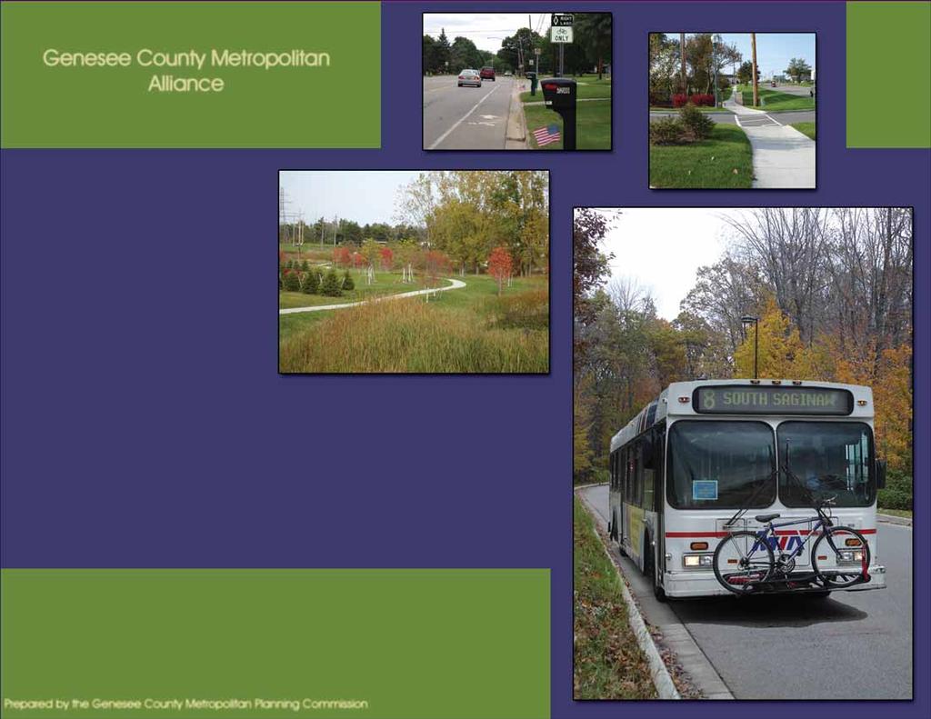
Genesee County Regional Trail Plan. Genesee County Metropolitan Alliance August 2007
|
|
|
- Annice Hodges
- 5 years ago
- Views:
Transcription
1
2
3 Genesee County Metropolitan Alliance August 2007

4 Mark Corba Dan Adamson Genesee County Board of Commissioners City of Burton City of Clio City of Davison City of Fenton City of Flint City of Flushing City of Grand Blanc City of Linden City of Montrose City of Mt. Morris City of Swartz Creek Argentine Township Atlas Township GENESEE COUNTY METROPOLITAN ALLIANCE 1101 Beach Street, Room 223 Flint, Michigan Telephone: (810) Fax: (810) Robert Johnson, Chairperson Robert Cole, Vice-Chairperson Ronald Flowers, Treasurer Trustees: Esther Galuszka Leslie Hasselblad Participating Agencies: Clayton Township Davison Township Fenton Township Flint Township Flushing Township Forest Township Gaines Township Genesee Township Grand Blanc Township Montrose Township Mt. Morris Township Mundy Township Richfield Township Thetford Township Vienna Township Marian Michalik Gaines Village Goodrich Village Lennon Village Otisville Village Otter Lake Village Federal Highway Administration Genesee County Drain Commission Genesee County Road Commission Genesee County Planning Commission Mass Transportation Authority Michigan Department of Transportation i
5 GENESEE COUNTY BOARD OF COMMISSIONERS Archie Bailey (Chairperson) Miles Gadola Woodrow Stanley Rose Bogardus Jamie Curtis Ted Henry John Northrup Raynetta Speed Patricia Lockwood GENESEE COUNTY METROPOLITAN PLANNING COMMISSION 1101 Beach Street, Room 223 Flint, Michigan Telephone: (810) Fax: (810) Alan Himelhoch, Chairperson Alexander H. Isaac, Vice-Chairperson Gloria J. Nealy, Secretary Miles Gadola Woodrow Stanley Robert W. Ranger, Jr. Charles Banks, Jr. Gayle I. Reed Ron Winters Shirley Brockhahn Ted Henry ii
6 GENESEE COUNTY METROPOLITAN PLANNING COMMISSION STAFF Julie Hinterman, Director-Coordinator Derek Bradshaw, Principal Planner Chris Kiesling, Principal Planner Shelia Auten, Senior Planner Jason Nordberg, Senior Planner Sheila Taylor, Senior Planner Stanley Brantley, Associate Planner Sharon Gregory, Associate Planner Heidi Peterson, Associate Planner Nate Scramlin, Associate Planner Terry Thomas, Associate Planner Carl Thompson, Associate Planner Christine Pobocik, GIS Specialist George MacEachern, Rehabilitation Inspector Greg Mitchell, Rehabilitation Inspector Kim Stowell, Rehabilitation Intake Coordinator Julie Chapman, Accountant Susan Schantz, Accountant Alberta Gunsell, Secretary Nichole Odette, Secretary Sylvia Willis, Secretary iii
7 ACKNOWLEDGEMENTS We would like to thank some of our partners in the development of this trail plan for their participation, insightful ideas, and collaborative efforts. Genesee Regional Trail Council members Technical Advisory Committee of the Metropolitan Alliance Genesee County Parks and Recreation City of Chicago Department of Transportation Federal Highway Administration Michigan Department of Transportation Michigan Department of Natural Resources Ruth Mott Foundation Center for Applied Environmental Research- University of Michigan- Flint Genesee County Road Commission Mass Transportation Authority Flint River Trail Partnership Flint River Watershed Coalition Friends of the Flint River Trail Sierra Club Neppessing Chapter Genesee Wanderers Flint River Corridor Alliance Genesee County Land Bank Michigan Trails and Greenways Alliance National Parks Service Flint Journal And all the local units of government who helped find the best trail connections through their communities iv
8 Table of Contents Acknowledgements Table of Contents Executive Summary Map: Top 10 Trail Priorities for Genesee County Introduction Map: Potential Trail Connections in Genesee Co. Map: Regional Connections i v vii viii Chapter 1: Purpose and Process 1 Project Overview 1 Genesee Regional Trail Council 1 Planning Process 2 Plan Development 2 How to use this plan 3 Definition of trails 4 Vision Statement 4 Goals, Objectives and Measures of Effectiveness 5 Benefits of Building a Non-motorized System 12 Chapter 2: Existing Trail Systems 14 Flint River Trail 15 George Atkin Jr. Recreational Trail 15 Flushing Riverview Trail 16 Grand Blanc Bike Path 16 Swartz Creek Bike Lane 17 Shiawassee River Walk 17 Linden Bike Lane 18 Goodrich Area Bike Path 18 M-21 Non-motorized Path 19 Court Street Bike Lane 19 Flushing Bike Lane 19 Genesee Road Trail 19 Davison Township Trail 19 ix x xi Chapter 3: Existing Trail Initiatives 20 Trolley Line Trail 21 M-15 Recreational Heritage Route 21 Friends of the Flint River Trail 22 Southern Links Trailway 23 Chapter 4: Existing Park Systems 24 Linden County Park 25 For-Mar Nature Preserve and Arboretum 25 Genesee Recreation Area 26 Flushing County Park 26 Jack N. Abernathy Regional Park 27 Ligon Outdoor Center 27 Kearsley Park 28 Flushing Township Nature Park 28 Kelly Lake Park 28 Dauner-Martin Nature Sanctuary 28 Chapter 5: Preferred Corridors 29 Argentine Township 30 Atlas Township and Village of Goodrich 32 City of Burton 34 Clayton Township and Village of Lennon 36 Davison Township and City of Davison 38 City of Fenton, Linden and Fenton Township 40 City of Flint 42 Flint Township 46 Flushing Township and City of Flushing 48 Forest Township, Village of Otisville and Village of Otter Lake 50 Gaines Township and City of Swartz Creek 52 Genesee Township 54 City of Grand Blanc and Grand Blanc Township 56 Montrose Township and City of Montrose 59 Mt. Morris Township and City of Mt. Morris 61 Mundy Township 63 Richfield Township 65 v
9 Table of Contents Thetford Township 67 Vienna Township and City of Clio 69 Chapter 6: Design Considerations 71 General Design Guidelines 72 Bike Lanes 72 Bike Routes 73 Path in Right-of-Way 74 Recommended Dimensions for Non-Motorized Trails and Paths 74 Chapter 7: Funding and Implementation 75 Potential Funding Sources 76 Agency Policies and Contacts 79 Recommendations for Implementation 80 Road Construction Projects 82 Trail Associations 82 Cost Estimates 82 Applying for Funding 84 Trail Maintenance 85 Maintenance Agreements 86 Adopt-A-Trail 86 Chapter 8: Trail Signage 87 Trail and Bike Route Signs 88 Trail and Bike Destination Signs 88 Local Trail Sign Personalization 89 Share the Road Signs 90 Chapter 9: Trail Resources 91 Smart Growth 92 Safe Routes to School 92 GLS Greenlinks 93 Context Sensitive Solutions 93 Connecting Michigan: A Statewide Trailways Vision and Action Plan 94 Michigan Trails Map Viewer 94 Michigan Trails at the Crossroads: A Vision for Connecting Michigan 95 Trails for the Twenty-First Century: Planning, Design, and Management Manual for Multi-Use Trails 95 Guide for the Development of Bicycle Facilities, 3 rd Edition 95 Chapter 10: Next Steps 96 Genesee Regional Trail Council Next Steps 96 Further Trail Research 97 Genesee County Priority Trail Segments 99 Top 10 Trail Priorities for Genesee County 104 Flint River Trail 105 Genesee Valley Trail 105 CSX Railroad Line- South Flint 106 M-15 Heritage Route 106 Trolley Line Trail- North 107 Genesee Regional Trail Council 107 GCMPC Outreach and Education 108 Top Five Prioritized Trails- Implementation 108 Appendix A: Signage Design 109 CADD Drawings 110 Appendix B: Sample Maintenance Agreement 113 Appendix C: Public Input 119 Genesee Regional Trail Council Comment Sheets 120 Public Input Sessions 128 Public Comment and Public Hearing 187 vi
10 Executive Summary Executive Summary The has been developed to provide a framework for creating an interconnected system of trailways throughout Genesee County. The Genesee Regional Trail Council, an informal group of trail advocates have proposed a vision that the Genesee County Regional Trail System will provide to a diverse range of residents and visitors a well-maintained, countywide, multi-use trail system that enables non-motorized users to safely access communities and natural areas within and outside of the county. The goals of this plan and initiative are: trail connectivity, alternative transportation, safety for all users, recreational opportunities, providing resources for implementation and education. Trails provide many benefits to the community including an improved transportation system, health and safety, environmental preservation and economic vitality for the community. Trailways are an important component of creating a livable community and attracting a talented workforce to Genesee County. There are trails found throughout most areas of Genesee County, yet they are not interconnected. In this plan you will discover potential trail connections identified by the Genesee Regional Trail Council and developed with help from local communities, trail advocates, transportation planners, educational institutions, and lots of public input. Every area of the county has some potential trail connections outlined in this plan. Design standards and guidelines for good trail development have been outlined. Funding and implementation strategies are also included. A new trail wayfinding system for Genesee County is incorporated into this plan with informational signage that provides distance, direction and destination information. The signage standards described herein bring uniformity to the trail network while also allowing for personalization for each trail and local community. Resources for new trail development are included and contact information on new initiatives locally and statewide that can benefit Genesee County s non-motorized planning efforts. The provides an action plan and next steps to building an interconnected regional trail system. The most important connections have been prioritized and this is where we will focus our efforts to begin developing Genesee County s trail system. The top ten trail projects for Genesee County are included on the next page. See you on the trails! vii
11 viii Executive Summary


12 Introduction What If What if we brought together all the communities of Genesee County to form a shared vision for an interconnected trail system, Imagine Linking communities to each other, Imagine if all the residents and visitors of our area had hiking, biking, and walking trails connecting our cities and villages. Imagine if you were able to walk to work, school, or the store through a safe and inviting trail system. Imagine if residents had opportunities to really enjoy and experience their natural environment without having to drive hours up north. Linking people to their community and their environment? ix

13 x Introduction

14 xi Introduction

15 1 Purpose & Process Chapter 1: Purpose and Process Project Overview Support for building a regional trail system in Genesee County has grown over the last few years and it was found that the County lacked a united guiding plan and vision for creating a trail system that connects urban, suburban and rural communities. 1 The Genesee County Metropolitan Planning Commission (GCMPC) functions as staff to the Genesee County Metropolitan Alliance (GCMA), the Metropolitan Planning Organization (MPO) for the Flint-Genesee County area. The GCMPC provides staff resources, technical support and services to assist Genesee County municipalities with the needs and demands of a rapidly urbanizing county. For many GCMPC has provided technical assistance to local trail groups on a project by project basis, helping to build trails one trail at a time. In 2006, the GCMPC formed the Genesee Regional Trail Council which was the entity that guided the development of the following regional trail plan. Genesee Regional Trail Council The Genesee Regional Trail Council (GRTC) serving as the informal stakeholder group for the trail plan met throughout the development of the and provided tremendous input into the planning process and outcomes of the plan. The GRTC consists of representatives from local communities, Friends of the Flint River Trail, M-15 Heritage Route, Clio Area Pathways, Genesee County Parks and Recreation Commission, Genesee County Road Commission, Genesee County Land Bank, Mass Transportation Authority, Michigan Department of Transportation, University of Michigan-Flint, Ruth Mott Foundation and numerous other groups. The purpose of the GRTC is to create an interconnected system of trails linking people and communities throughout Genesee County and guide the development of the countywide trail plan.

16 Purpose & Process Genesee Regional Trail Council meetings were held throughout the plan development process. These meetings were used to define the opportunities and constraints to building trails, develop a vision for trails in Genesee County, discuss elements to include in the plan, delineate potential connections linking pieces of existing planned routes, discuss trail issues, and determine a strategy for outreach, public involvement and implementation. During the summer of 2006 GCMPC staff met with local municipalities and other entities and/or corresponded via phone and with their preferences on the regional trail system and to discuss the potential trail connections. Planning Process This trailways master plan for Genesee County was developed over a six month period and with the GRTC serving as the steering committee for the plan. The project has brought together various trail groups from across Genesee County and local government officials interested in building trail connections in their community. The plan built on the existing parks and recreation plans of individual municipalities throughout the county and individual trail plans, bringing all of these together into a comprehensive trail plan. Funding and staff time for this plan was provided by the Genesee County Metropolitan Planning Commission. Plan Development The process began with the gathering of all existing and planned trail routes in Genesee County. As part of the 2030 Flint-Genesee County Long-Range Transportation Plan, extensive GIS data on trails had already been gathered in GCMPC Staff reviewed all current parks and recreation plans for additional trails and composed a series of maps consisting of existing trails, proposed trails, destinations and regional connections for the GRTC to use to fill in the gaps in the system. The GRTC continued to refine the trail maps and provided detailed information on the feasibility of linkages and new potential connections throughout the county. 2

17 Purpose & Process The purpose of this plan is to: How to use this plan Provide the tools necessary to enable local units of government and trail advocates to plan for, design, fund and implement non-motorized trails throughout Genesee County. Unite a diverse group of stakeholders in the community to draft a vision of interconnected nonmotorized trails linking communities, cultural and educational destinations and natural areas throughout Genesee County. Educate the public on the benefits of non-motorized trails and their importance in creating livable communities. Create the framework for building the Genesee Regional Trail System, a safe, convenient and attractive system of non-motorized trails connecting throughout Genesee County and into the surrounding counties. The is a guide for planning and developing trails in Genesee County. It clarifies the regional linkages needed to connect individual trail plans of our cities, townships and villages. This plan lends support and justification for funding requests by local units of government, collaborative partnerships and transportation agencies. In nearly all sources of funding from state and federal programs to foundations and philanthropic organizations, trail projects that are part of a regional trail network and in an adopted regional plan are looked upon in a favorable light. Municipalities and trail advocates should utilize this plan to seek funding support and other assistance in their trail development and improvement efforts. This plan is also a guide on where to locate information and resources needed to build trails and help answer questions on implementation, funding and maintenance so that our regional trail system is equitable and sustainable. This plan is a living document that represents the current non-motorized transportation needs in Genesee County. This plan will need to be updated periodically as sections of trails are built, other potential trail connections are found or the needs of the community change. 3


18 Purpose & Process Where trail connections are sought and sidewalks or walking paths exist, the sidewalks or walking paths are included in the trail plan as a connector and a starting point to further upgrade at a future date into a multi-use trail. This plan does not intend to be a comprehensive inventory of sidewalks. Vision Statement Non-Motorized Vision for Genesee County The Genesee County Regional Trail System will provide to a diverse range of residents and visitors a well-maintained, countywide, multi-use trail system that enables nonmotorized users to safely access communities and natural areas within and outside of the county. Definition of Trails For purposes of this document trail will be defined as a non-motorized transportation route including: on-road facilities such as bike-lanes (areas defined as bike-lanes will be labeled as such in the plan), multi-use non-motorized paths in the road right-ofway, multi-use non-motorized paths in utility corridors or abandoned railroad corridors, foot-trails or walking trails (areas defined as walking trails will be labeled as such in the plan), sidewalks (areas defined as sidewalks will be labeled as such in the plan). 4


19 Purpose & Process Goals Connectivity Alternative Transportation Objectives and Safety Recreational Opportunities Implementation Resources Education Measures of Effectiveness 5

20 Purpose & Process Goal: Connectivity To facilitate the development of an interconnected regional trail system in Genesee County comprised of accessible sidewalk systems, bike lanes and nonmotorized multi-use paths Objectives: To create trail heads, turnouts, viewing stations and interpretive signs along trails To connect non-motorized multi-use trails into the fixed route bus system in Genesee County where feasible To combine different types of non-motorized routes such as rail-trails, road right-of-way, utility corridors, river and other natural corridors through easements, right-of-way and purchase into an interconnected non-motorized system To provide accessible and convenient non-motorized routes to destinations throughout the county such as schools, commercial areas, recreational facilities, community and cultural centers and other areas To improve existing facilities and make them more useable, well maintained, accessible to the disabled and easy to find To improve signage for trails through a clear and concise unified signage in Genesee County Measures of Effectiveness: Current trails are extended into neighboring cities, villages and townships Missing linkages in existing trails are built To link existing trails and create loop trails To ensure that new facilities are built to American Association of State Highway and Transportation Officials (AASHTO) design standards and are accessible to those with mobility challenges Access for persons with mobility issues is improved on existing trails and sidewalks Accessible bus stops interconnecting with the trail system are planned for and built A countywide trail wayfinding system is adopted and constructed 6

21 Purpose & Process Goal: Alternative Transportation To create safe, accessible, and convenient routes to schools and places of work in Genesee County that promote walking and biking as an alternative form of transportation and that integrate into other existing transportation systems Objectives: To promote a Safe Routes to School program in area schools To promote bicycling and walking to work To encourage alternative transportation for short trips (under 2 miles) To incorporate bicycle and pedestrian friendly and design and considerations into transportation improvement projects Measures of Effectiveness: Increased use of trailways as a transportation alternative for commuting to work To encourage local businesses to provide bicycle racks, interconnected sidewalks, and employee incentives to choose alternative forms of transportation. Increased participation from local schools in the Safe Routes to School program Increased use of trailways as a transportation alternative for short trips (under 2 miles) 7

22 Purpose & Process Goal: Safety To have the ability to safely travel to community destinations, transit and recreational facilities without the use of a motor vehicle Objectives: To minimize conflicts between pedestrians, bicyclists, and vehicles while accommodating each type of travel To eliminate obstacles to non-motorized travel for all users To improve the safety of the existing non-motorized system To provide signs and/or signals for at grade street crossings Measures of Effectiveness: All trailway and road crossings at-grade are properly signed and marked Increased awareness of bicyclists and pedestrians as valid users of the transportation system Decrease in the number of vehicle-bicycle crashes in Genesee County Decrease in the number of vehicle-pedestrian crashes in Genesee County Safety improvements made to the transportation system in Genesee County for pedestrians and bicyclists 8

23 Purpose & Process Goal: Recreational Opportunities To increase access to recreational opportunities for people of all ages, ethnicities and levels of mobility Objectives: To provide access to parks and natural areas via trail connections To preserve wildlife habitat along trail corridors To promote active living To improve opportunities to exercise for Genesee County residents Measures of Effectiveness: Increased use of trails in Genesee County for recreation purposes Increased us of park and recreation areas in Genesee County Increased use of trailways in Genesee County for organized fitness, training and running programs. To encourage use of parks and natural areas in Genesee County 9


24 Purpose & Process Goal: Implementation Resources To provide local trail groups and municipalities with the resources and knowledge needed to implement the regional trail plan Objectives: To peruse state, federal and private grants to help local units of government to construct non-motorized trails To help build relationships between local units of government and foster multi-jurisdictional planning for trails and sharing of resources for recreational and transportation means To identify long term maintenance solutions for existing trails To prioritize sections of trail for funding in an equitable manor Measures of Effectiveness: To use existing rights-of-way, public lands, utility and rail corridors where possible to minimize cost of implementation Creation of a regional trail system in Genesee County Multi-jurisdictional efforts to build interconnected trails in Genesee County Increase in funding for trailways within Genesee County from local, state, federal, non-profit and private funding sources 10

25 Purpose & Process Goal: Education To build public support and awareness of trails in Genesee County Objectives: To inform the public about the benefits of using trails To teach bicycle and pedestrian safety to trail users and motorists To show people where trails exist in Genesee County To establish outdoor classrooms and signage along trails that teach historical, environmental, and natural sciences To educate elected and government officials on the importance of trails for healthy living, economic development and quality of life for the residents of their community Measures of Effectiveness: Increased awareness and use of trailways in Genesee County To develop promotional materials, maps, web pages and education packets that highlight trails and the benefits of trails to the community To promote volunteerism and environmental stewardship by having the public help maintain trails through an adopt-a-trail program or friends of the trail group Development of a trailways map for Genesee County of existing trails Increased public demand for trailways as part of an interconnected, multi-modal transportation system in Genesee County Availability and distribution of useful educational materials on current trailways, their benefits, bicycle and pedestrian safety and trail development resources 11

26 Purpose & Process Benefits of Building a Non-motorized System Transportation Benefits Non-motorized trails provide an alternative form of transportation to the automobile. Trails also help to relieve congestion on our roads by getting people out of their cars and off of the streets for their trips. Health Trail users have an extra opportunity for increased physical fitness. As the national obesity epidemic is quickly becoming one of the largest health problems we are currently facing, trails provide one inexpensive means to get exercise and can be part of a healthy lifestyle. Trails provide students a healthy alternative to get to and from school. Safety Benefits to the Community Trails are part of creating a livable community. Trailways connect adjacent cities and also create social connections between different groups of people. They provide beautiful public spaces for people to enjoy, and can be used to enhance existing infrastructure and community facilities, such as parks, schools, libraries, downtowns and cultural centers. Trails create a safe way for hikers and bikers to get to their destinations without having to use busy streets. They can also provide children with a safe route to school. Most of our community schools were designed to be walked to by students. Despite this being the case, it is an all too common scene these days to see congested streets around schools as parents pick-up and drop-off their kids. Our school parking lots become a hazardous zone with so many people arriving and departing at the same time. 12


27 Purpose & Process Environmental Trailways help connect people to their physical environment and foster an appreciation for nature. Non-motorized trails are a wise use of our dwindling resources as they re-use urban land and preserve open space along river corridors and wetlands. They help to improve air quality by taking vehicles off the road and lessening our carbon output. Economic Trails bring economic opportunity to our county. Trail users spend money in the cities and towns they travel through along the way. New businesses open up to take advantage of the increased foot traffic along the way. Businesses looking to relocate are drawn to the types of communities that provide the best quality of life for their employees and an interconnected non-motorized trail system does just that. For the consumer, trails have a great economic benefit; they save on gas prices and the cost of car maintenance. With the cost of fuel rising every year, many more of us will be looking for alternative forms of transportation. 13 For more information on the economic benefits of trails to the community visit the Pierre-Marquette Rail Trail website at

28 2 Existing Systems Saginaw Street Grand Blanc 14


29 Existing Systems Introduction There are a number of trails and bike paths in Genesee County. This chapter identifies Genesee County s existing trail infrastructures. The proposed trail system for Genesee County will link these trails and add future amenities. Sunday from May through October the Friends of the Flint River Trail ride at 2:00 p.m. starting at the Flint Farmers Market in downtown Flint. Flint River Trail The Flint River Trail is a multi-use trail that follows the path of the Flint River. It begins at the University of Michigan- Flint campus in the City of Flint and has two terminus in the Genesee Recreation Area, Bluebell Beach and Stepping Stone Falls. The trail is approximately 12.4 miles in length and includes a loop through Kearsley Park. The trail is mostly paved and is suitable for biking, jogging or walking. Every 15 George Atkin Jr. Recreational Trail (Formerly called Clio Area Bike Path) The George Atkin Jr. Recreational Trail is a multi-use trail located along Pine Run Creek in the City of Clio and Vienna Township. The trail can be accessed from parking lots which are located off Jennings, Wilson and Neff Road, as well as in the Clio City Park. The trail is suitable for biking, running, walking and roller-sport activities. It winds through woodlands, parks and residential and commercial areas, and is approximately five and one-half miles long. An unusual feature of this trail is the series of tunnels and bridges that offer the user an uninterrupted travel path through the local infrastructure.

30 Existing Systems Flushing Riverview Trail The Flushing Riverview Trail goes from the downtown Flushing Main Street Bridge to the Flushing County Park and is approximately 1.4 miles long. The trail has rest area bumpouts with benches and tables that were hewn out of the trees logged from the actual trail route. The route includes a 72 span bridge over Cole Creek and a 200 bridge over the Flint River. The trail is suitable for walking, biking, roller-sports or any other non-motorized mode of transportation. It has a fishing pier and pedestrian bridge that provide Americans with Disabilities Act (ADA) accessible fishing opportunities. Grand Blanc Bike Path This bike path follows Grand Blanc Road and is approximately 2 miles long. It goes from the western city limits of Grand Blanc to Bicentennial Park in Grand Blanc Township. It is suitable for walking, jogging, roller-sport activities and biking. 16


31 Existing Systems Shiawassee River Walk This multi-use trail is located in the City of Fenton and is approximately one-half mile long. It extends from O Donnell Park located on the Fenton Mill Pond to Caroline Street. The River Walk, which follows the pond, has benches and is close to playground equipment and the Community Center. Swartz Creek Bike Lane The Swartz Creek Bike Lane is approximately two miles long. It extends along Miller Road from Seymour Road to Elms Road, located within the city limits. The bike lane has proper signage and lane markings. 17
 within the village limits. The bike path is approximately two miles long.")
.")
32 Existing Systems Goodrich Area Bike Path The bike path follows Hegel Road from the intersection of Gale Road in Atlas Township to Oaktree Elementary in the Village of Goodrich. It also extends along M-15 (State Road) within the village limits. The bike path is approximately two miles long. Linden Bike Lane This bike lane is located in the City of Linden, and extends from Rolston Road to Silver Lake Road. It is approximately three and one-half miles long. The bike lane has proper signage and lane markings. It extends from the west city limits to the east city limits along Broad Street (Silver Lake Road). The bike lane also follows Bridge Street (Linden Road) from Broad Street to the north city limits. It then continues along Rolston Road from Bridge Street to the east city limits. 18

33 Existing Systems M-21 Non-motorized Path This ten-foot-wide paved non-motorized path is located in Flint Township and follows the north side of M-21 (Corunna Road) from Dye Road to I-75. The path is about one and onehalf miles long. Court Street Bike Lane This bike lane is located within the City of Burton and follows Court Street from Belsay Road to Vassar Road. The bike lane is approximately one and one-half miles long and has access to Bentley Middle and High Schools. Flushing Bike Lane The City of Flushing has striped a bike lane on McKinley Road from the northern city limits to downtown Flushing. Genesee Road Trail in Grand Blanc A 10-ft non-motorized path runs along the western edge of Genesee Road in the City of Grand Blanc from ½ mile south of Hill Road to Perry Road. There are plans to eventually extend the trail to Hill Road in Grand Blanc Township. This pathway links into the City of Grand Blanc sidewalk system at Perry Road heading westward. Davison Township Trail Davison Township has a new trail completed in 2006 that runs from behind the township hall on Irish Road eastward to Gale Road. It ends ½ mile from Jack Abernathy Regional Park in Davison. 19

34 3 Existing Trail Initiatives Flint River Trail Flint, Michigan 20

35 Existing Trail Initiatives The builds on the work of many trail initiatives that have been working to build trails in the area. This chapter introduces these groups and their projects. Trolley Line Trail The Clio Area Trolley Line Trail group is working to develop a trail along the historic Clio Trolley Line. The Clio Trolley Line is the name for the old inter-urban railway line that used to run from Saginaw through Flint to Detroit. Vienna Township has received a grant to build the trail from Field Road to Willard Road (2.5 miles). The trail when built will run from Mt. Morris to Birch Run. M-15 Recreational Heritage Route The M-15 Recreational Heritage Route was Michigan's first Recreational Heritage Route. It extends from Ortonville in Northern Oakland County to the northern terminus of M-15 east of downtown Bay City, approximately 90 miles. It covers 19 communities in Oakland, Genesee, Tuscola and Bay Counties. The Route offers summer festivals, shopping, restaurants and activities such as camping, fishing, biking, hiking and horseback riding. For more information visit their website at 21


36 Existing Trail Initiatives Friends of the Flint River Trail Map was printed. The FFRT is now partnered with the Flint River Watershed Coalition and working to get improvements made to the existing trail that will increase safety and provide signage. The Friends of the Flint River Trail hopes to establish a beautiful, integrated trail system that will some day extend along the full length of the Flint River through Genesee County, becoming the core of a county-wide trail system. Eventually, the trail will connect with trails in bordering counties. The Friends of Flint River Trail (FFRT) are an active group of trail advocates whose purpose is to promote greater use of the trail through improved safety, maintenance and publicity; to improve facilities along the trail; and to extend the trail s length and move toward a city/county trail system. The FFRT host weekly bike rides along the Flint River Trail every Sunday, May through October at 2:00 p.m. beginning at the Flint Farmers Market (rain or shine). They also work to keep the trail clean with an annual clean-up the last weekend in April. The FFRT have a website for more info or to join the group go to The Friends of the Flint River Trail have been working with the Greater Flint Health Coalition s Health Improvement Committee, with a grant from The Ruth Mott Foundation, to promote use of the trail and through this effort a new trail 22

37 Existing Trail Initiatives Southern Links Trailway The Southern Links Trailway is located on an old railroad bed and passes through portions of three counties: Genesee, Tuscola and Lapeer. This linear park spans approximately 10 miles, passing through the Village of Columbiaville, Marathon Township, the Village of Otter Lake, Forest Township, Millington Township, the Village of Millington, Vassar Township and the City of Vassar. The Friends of the Southern Links Trailway is a group of concerned trail enthusiasts who promote and support the trail s development. The Friends promote the trail to local residents, organizations and businesses. They also raise funds and provide volunteer labor for the trail. Long-range goals include extending the trailway north to Reese, as well as to the Polly Ann Trail in Lapeer County and to the M-15 Heritage Route. For additional information go to their website at 23

38 4 Existing Park Systems Elms Park Swartz Creek 24


39 Existing Park Systems Many of the non-motorized trails in Genesee County are within one of our beautiful parks. This chapter lists and describes all of the parks that have non-motorized trails. This chapter is not meant to be a full description of all of the amenities these parks have to offer. Linden County Park County Parks Linden County Park is located on Linden Road, south of Silver Lake Road in Fenton Township. It has a designated walking area with distances marked for convenience. The trail is approximately one and one-half miles long, and is marked at the ¼ mile, ½ mile, ¾ mile, 1 mile, 1 ¼ mile and 1 ½ mile points. The trail has access to restroom facilities. For-Mar Nature Preserve & Arboretum The For-Mar Nature Preserve is located on North Genesee Road in the City of Burton, between Davison Road and Potter Road. The Preserve has designated walking trails with distances marked for convenience. There are eight named trails to choose from, along with the Maple Walk, the Lilac Walk and grass trails. The Preserve has a total of seven miles of trails, however, no biking or jogging is allowed. 25


40 Existing Park Systems Genesee Recreation Area The Genesee Recreation Area is located in Genesee and Richfield Townships and offers several trails, such as the Bluegill Boat Launch Trail. This trail is located at Coldwater Road and Genesee Road. It is a 1 ½ mile long paved trail, and is marked at the 1/8 mile, ¼ mile, ½ mile, ¾ mile, 1 mile, 1 ¼ mile and 1 ½ mile points. Restroom facilities are available on this trail, as well as access to Mott Lake and free parking. The Bluebell Beach Trail is approximately five-eights of a mile long, and is marked at the 1/8 mile, ¼ mile, ½ mile and 5/8 mile points. It is located off Bray Road north of Carpenter Road in Genesee Township. The trail includes restroom facilities and has access to the Splash Pad Playscape, the beach and Mott Lake. Also, a portion of the Flint River Trail (.8 mile long paved trail) links Carpenter Road and Bluebell Beach. Flushing County Park Flushing County Park is located on North McKinley Road and has Carpenter Road as its northern border. The park s onemile trail is marked at the 1/8 mile, ¼ mile, ½ mile, ¾ mile and one mile points. The trail has access to a playscape and links to the Flushing Riverview Trail. 26


41 Existing Park Systems Other Parks with Trails Jack N. Abernathy Regional Park Jack N. Abernathy Regional Park is located on Frank Boyce Parkway, off Dayton Street and Harvey Drive in the City of Davison. Trail offerings of the park include an 18 station fitness trail, miles of nature trails, and a 1.7 mile ADA (Americans with Disabilities Act) accessible trailway. Ligon Outdoor Center Ligon Outdoor Center is located on East Farrand Road in Thetford Township. Ligon provides teachers and students in the Genesee and Lapeer Intermediate School Districts with a natural setting for learning and teaching. Ligon may also be used by any recognized organization in Genesee County for retreats, conferences, field trips and special events. Ligon includes 6.5 miles of hiking trails, including an ADA (Americans with Disabilities Act) accessible trailway, an Esker Trail and a Boardwalk. 27


42 Existing Park Systems Kearsley Park- City of Flint Kearsley Park is located in the City of Flint off Kearsley Boulevard north of Robert T. Longway Boulevard. A portion of the Flint River Trail goes through Kearsley Park, and connects just south of Hamilton. This multi-use trail goes from Longway Boulevard near Applewood through the park, under I-475 then through Dayton Park back to the trail. Flushing Township Nature Park Flushing Township Nature Park is located on McKinley Road north of Mt. Morris Rd. The park offers trails for biking, walking, jogging and horse back riding. There is a boardwalk extending over wetlands, a ¾ mile trail adjacent to the Flint River and a scenic observation tower. Kelly Lake Park Kelly Lake Park is located in the City of Burton just south of I-69 and east of Genesee Road. This 40-acre park has nature trails, a pavilion, a bike path and Kelly Lake. Dauner-Martin Nature Sanctuary Dauner-Martin Nature Sanctuary is a 150-acre park in the City of Fenton. It is located just east of Leroy Street and north of Dauner Rd. This nature area is closed to biking and is for foot traffic only. There are approximately 4.3 miles of unpaved hiking trails, with parking and entrances off of both Leroy Street and Dauner Road. 28

43 5 Preferred Corridors 29


44 Argentine Township Preferred Corridors Shiawassee River at Seymour Road, proposed trail Silver Lake Road proposed trail 30

45 Argentine Township Preferred Corridors Regional Corridors A 10-ft wide non-motorized pathway is proposed for the right-of-way along Silver Lake Road in Argentine Township, from the City of Linden and Fenton Township to Burns Township in Shiawassee County. As an alternate route, the trail could run down Lobdell Road behind the Linden High School, Middle School and Central Elementary, and then meet back up with Silver Lake Road at the Linden City Limits. This connection would link Argentine with the Linden Community Schools, as well as provide a potential link to Byron in the future. Further Issues and Considerations A Consumer s Energy line exists (running east/west) in Livingston County approximately 2 miles south of the county line. This line could serve as a trail corridor and would need to be developed by Livingston County, although no current considerations for this trail connection exist. It could also connect with the Oak Grove State Game Area in Livingston County. Seymour Road connects Argentine Township to the City of Swartz Creek to the north and south into Livingston County. A 10-ft wide paved trail along Seymour Road, through the entire length of the township, would provide a regional north-south linkage in this rural portion of the county. It could be constructed in mile long segments in conjunction with the reconstruction of Seymour Road by the Genesee County Road Commission. Trailheads Linden Community Schools and the Market in Argentine could both serve as excellent trailheads for this area. Market in Argentine on Silver Lake Road 31


46 Atlas Township & Village of Goodrich Preferred Corridors Hegel Road Pathway, Goodrich M-15 Heritage Route, future trail site, Atlas Twp 32
47 Atlas Township & Village of Goodrich Preferred Corridors Regional Corridors The M-15 Recreational Heritage Route traverses through Atlas Township and the Village of Goodrich. Inside the village limits newly built sidewalks allow for pedestrian access from Mill Pointe Drive to Hufstader Road traversing nearly the entire village. This is the only section of the Heritage Route currently built in the Atlas Township and Goodrich area. The M-15 Heritage Route Committee, in partnership with MDOT, is persuing construction of a segment of trail extending from the Goodrich Village limits north to Maple Avenue at the edge of Atlas Townsip. The Trolley Line Trail - South is a Consumer s Energy corridor that connects the City of Burton, through Atlas to the Village of Goodrich. This trail is part of the old interurban trolley line that once ran through Genesee County. In many sections near the Village of Goodrich the land is privately held. It would take considerable effort to reconstruct this line. In order to be built, the trail would need an easement from five property owners The Baldwin Road and Gale Road bike lanes connect with the proposed bike lane along Baldwin Road in Grand Blanc Township. The bike lane will also serve the students of Goodrich Area Schools. Traffic counts on this section of Baldwin and Gale Roads range from 3500 to 4400 vehicles per day (low volume). The Thread Creek Trailway is another potential connection/preservation corridor running through both Grand Blanc Township and Atlas Towsnhip along Thread Creek. A branch also extends into the Goodrich Area Schools complex on Gale Road. This corridor would involve easements through private property for most of its length, but would be a picturesque trail corridor. Trailheads A trailhead could be located at the Goodrich High School located on Hegel Road, where ample parking is available. Another potential trailhead is the Goodrich Village offices on M-15 at the northern edge of the village. A Consumer s Energy corridor runs westward from M-15 south of Horton Road and turns southward just before Gale Road. This corridor connects into Oakland County and Holly Recreation Area State Park. This corridor has also been identified by Oakland County Planning and Development Commission and Headwaters Trails Inc. as a regional connection with Genesee County. Hegel Road east of M-15 connects the Atlas Township and Goodrich area with Ortonville Recreation Area in Lapeer County. A 10-ft non-motorized path leading into the park area would connect this park to the Genesee County trail system. 33


48 City of Burton Preferred Corridors Kelly Lake Park, City of Burton Consumer s Energy Corridor 34

49 City of Burton Preferred Corridors Regional Corridors The City of Burton is bisected by a system of Consumers Energy corridors that have been identified for trail development. The feasibility of using these corridors, stretching south from I-69 to the southeast corner of the city, for trail development is promising. There are a few locations where portions of the corridor have been sold to private landowners and easements would need to be acquired to complete the connection. The development of this Consumers corridor could link the City of Burton with Atlas Township, the Village of Goodrich, and potentially Oakland County. development. The identified Genesee Road connection extends from Court Street within the City of Burton north to M-57 in Thetford Township. Also identified is a bike route to For-Mar Nature Preserve that runs through the northern corner of Burton connecting it to the Flint River Trail and Kearsley Park. Trailheads Kelly Lake Park, located just south of I-69, may be a possible location for a trailhead. Access to the park is available on Lapeer Road and parking is available at the site. The abandoned CSX Railroad runs through the southwest portion of Burton potentially connecting them to the City of Flint, Grand Blanc Township and the City of Grand Blanc. This rail line has been identified for trail development in the City of Flint s Parks and Recreation Plan; therefore, these jurisdictions may want to collaborate to help make this connection. A route along Davison Road leading from the east side of the City of Flint to the City of Davison has been proposed. Local Connectors City of Burton could connect Kelly Lake Park to the broader trail network. The trail presently runs along I-69 from Genesee Road to Kelly Lake. The extension of this trail south on Munson Road to Lapeer Road then west to the Consumers Energy corridor is feasible. Also within the City of Burton, Court Street and Genesee Road have been identified as potential routes for trail Kelly Lake Park Trail 35


50 Clayton Township & Village of Lennon Preferred Corridors Miller Road, potential trail site, Clayton Twp. Seymour Road, potential bike lane, Clayton Twp. 36

51 Clayton Township & Village of Lennon Preferred Corridors Regional Corridors A proposed bike lane along Seymour Road would connect Flushing Township in the north and Gaines Township and the City of Swartz Creek to the south. Clayton Township also has an east-west utility corridor that belongs to Consumers Energy. If used for trails, this path could connect to Shiawassee County to the west and also intersect the potential Seymour Road bike lane. On the western boarder of Clayton Township, a bike lane is also proposed for the M-13 corridor from Saginaw County to Lansing Hwy/Miller Road. A proposed pathway on Lansing Hwy/Miller Road would follow the southern boarder of Clayton Township from the City of Swartz Creek to Shiawassee County and eventually to Durand. Another potential east-west trail or bike route would be along Grand Blanc Road or Baldwin Road, from Grand Blanc and Mundy Townships to Seymour Road. Trailheads Trailhead locations and amenities may need to be identified for the potential trail on Seymour Road. Seymour Road, potential bike lane, Clayton Twp. Further Issues and Considerations Approximately one mile west of Clayton Township, in Shiawassee County, is a Consumer s Energy corridor that runs nearly the full length of the township. This corridor could be pursued for trail development in partnership with Shiawassee County. 37


52 Davison Township & City of Davison Preferred Corridors Trail at Abernathy Regional Park, Davison Davison Township Trail along Black Creek 38
53 Davison Township & City of Davison Preferred Corridors Regional Corridors The M-15 Recreational Heritage Route, which is planned to extend along M-15 the entire length of the county, runs through Davison Township and the City of Davison. This regional corridor bypasses the intersection of M-15 and I-69 to take a turn down Lippincott Road, north on Oak Road, then into the City of Davison on Clark Street. This path takes the Heritage Route by Davison High School and two Elementary Schools, providing a Safe Route to School. A feasibility study for the M-15 Heritage Route was completed in No sections of the route have been built in the Davison Area yet. The Davison Road Corridor has been identified as a regional connection linking the City of Davison to the City of Burton and providing pedestrian and bicycling access to For-Mar Nature Preserve for Davison Area residents. In the City of Davison and in Davison Township, between Vassar Road and Irish Road, the trail exists as sidewalks along both sides of Davison Road. There is a missing section between Irish Road and the City of Davison. As an alternative route between the City of Davison and For- Mar Nature Preserve the trail could extend from Jack N. Abernathy Regional Park in Davison eastward, adjacent to the Grand Trunk Western Railroad on a trail segment completed in 2006 extending from Gale Road to Irish Road. Then, the trail could follow Irish Road north ½ mile to Davison Road and meet up with the sidewalk system on Davison Road. Or, the trail could continue westward along Black Creek to its junction with Kearsley Creek. The trail could then follow Kearsley Creek upstream to Court Street where it would connect with the planned route along Court Street and the entrance to Bentley Jr. High and High Schools. This route would be the most scenic and would connect Davison and Bentley Schools. This connection would also require easements from nearby property owners. Local Connectors A local route navigates through Jack N. Abernathy Regional Park and connects up with the regional trail system by either going into the City of Davison and up to Davison Road or by extending westward to Irish Road from the trail behind Davison Township Hall. Trailheads A possible trailhead has been identified at Jack N. Abernathy Regional Park. The 132 acre park is the main recreation area for City of Davison residents. It includes a playscape-style playground, skate park, pavilions, volleyball, tennis and basketball courts, horseshoe pits, softball fields, concession stand, and nature trails. Another trailhead could be the Davison Township Hall. It has ample parking and a new trail segment completed in Further Issues and Considerations There is a missing connection between the Black Creek Trail in Davison Township and the trail in Jack Abernathy Regional Park. Both trails stop within a ½ mile from each other. There is a need for these two trails to connect. A pedestrian bridge is needed over Black Creek from the Jack Abernathy Regional Park to one of the streets inside the City of Davison which dead end at the railroad and the creek. This would connect residents of the City of Davison north of the park to the Jack Abernathy Regional Park and the trail. 39


54 City of Fenton, Linden & Fenton Township Preferred Corridors Dauner- Martin Nature Sanctuary Trail, Fenton Shiawassee River Walk, Fenton 40
55 City of Fenton, Linden & Fenton Township Preferred Corridors Regional Corridors Fenton Road provides a link from the City of Fenton to northern Genesee County and into Burton and Flint. This is a heavily traveled corridor and any non-motorized facilities should be located as far off of the roadway as possible to minimize conflicts between pedestrians or bicyclists and motorists. Petts Road, off of Fenton Road, just north of the City of Fenton connects to Seven Lakes State Park. This provides a regional linkage into Oakland County. A power line runs from the park north into Grand Blanc Township and could provide a route into Grand Blanc from Fenton. Oakland County and the Headwaters Trails group have also identified this as a potential linkage between Oakland and Genesee Counties. Silver Lake Road connects the City of Fenton to the City of Linden and continues further westward into Argentine Township. This connection could provide a linkage for residents of the Linden Area to access the shopping areas near Silver Parkway and Silver Lake Beach in the City of Fenton. The Jennings Road corridor provides a link to Lake Fenton High School, as well as north into Mundy Township. Local Connectors These routes provide access to various destinations in the Fenton and Linden area and connect to the regional corridors: Dauner- Martin Nature Sanctuary Lahring Road Linden Road Lobdell Road North Road North Long Lake Road Owen Road Poplar Street Ripley Road Rolston Road Silver Parkway Shiawassee River Walk Shiawassee Avenue South Long Lake Road Torrey Road Whitaker Road Trailheads The Fenton Community Center has parking for the Shiawassee River Walk and serves as a trailhead. Another potential trailhead could be Linden County Park. Further Issues and Considerations No connections to Livingston County have been identified yet. The potential exists to connect in with the Consumers Energy corridor running east and west about two miles south of the county line in Tyrone Township. 41


56 City of Flint Preferred Corridors Former CSX Railroad, south of Court Street Former CN Railroad 42


57 City of Flint Preferred Corridors CN Railroad property, Flint Flint River Trail near Farmer s Market 43
58 City of Flint Preferred Corridors Regional Corridors The Flint River Trail The City of Flint has a wonderful asset in the current Flint River Trail. This extensive 12.3 mile trail system provides non-motorized options to a large majority of City of Flint residents. There are currently a few areas along the Flint River Trail that have been identified to improve connectivity. Stewart Water Treatment Plant The land surrounding the water treatment plant at Stewart Ave. should be looked at for trail feasibility. The current Flint River Trail has a missing link at the plant property. James P Cole Hamilton Ave At this point, the Flint River Trail currently continues on the street. There is an abandoned parking lot at the corner of these two streets owned by the General Motors Corporation. From there, running to the north, there exists a Consumers Energy Substation along the river. These two pieces of property should be examined for trail development. Abandoned CSX Railroad Another regional corridor within the City of Flint is the abandoned CSX Railroad. The CSX rail line runs from the City of Burton north to the downtown Flint area. This length of trail has been identified in the City of Flint Parks and Recreation Plan and should remain a priority, as it would connect to the Flint River Trail and extend it completely through the City of Flint from north to south. Along this abandoned line, there are refreshing natural areas including Spring Grove, a brownfield redevelopment site in the Grand Traverse Neighborhood. The Canadian National Railroad The abandoned Canadian National (CN) Railroad should also be identified as a priority for trail development. This trail has the potential of linking the City of Flint, Flint Township, and the City of Swartz Creek. At the point where the rail line meets I-75, it would be necessary to continue on Corunna Rd (M-21) and use the overpass to cross. The use of the MDOT right-of-way may be feasible on the west side of I- 75 to return to the CN rail line. Local Connectors A potential neighborhood bike route has been identified from Kearsley Park to For-Mar Nature Preserve: Missouri EB to Meade Meade NB to Davison Davison EB to Curry Curry NB to Risedorph Risedorph EB to Blackthorn Blackthorn NB to Thorntree Thorntree EB to For-Mar Entrance On the northern tier of the City of Flint, the Friends of the Flint River Trail (FFRT) have identified a small route for trail development. This trail would connect into Forest Park and a small trail portion identified in the City of Flint Parks and Recreation Plan with the proposed route: Along Dupont NB to Thackery Along Thackery & Wager EB to Selby Bike Lane SB on Selby, NB on Andrew Bike Lane from Stewart to James P. Cole 44

59 City of Flint Preferred Corridors Bike Lane from James P. Cole to Massachusetts Massachusetts through industrial park to Pasadena A connection from the Flint River Trail along the river bank to the western limit of the City of Flint has been identified. This connection utilizes both trails along the river, sidewalks and bike lanes, some of which are included in the Flint River District Strategy. McLaren Hospital has identified a portion of their land for trail development north of Beecher Road and east of Ballenger Highway. McLaren has expressed an interest in connecting this trail with the larger regional system. New Trail Development The Ruth Mott Foundation, Mott Community College, and the City of Flint have partnered to build a new section of trail south of Robert T Longway Blvd along Gilkey Creek through the Mott Community College Campus and next to Applewood Estate. The trail will also involve removal of channelization measures and habitat restoration along Gilkey Creek. The trail will connect to the Kearsley Park Trail and run southward to Court St. Downtown Bike Lanes GCMPC staff has identified a number of routes for bike lane development in the downtown Flint area: 3rd Avenue/Sunset Drive: from Saginaw Street. to Ballenger Hwy Second Street: from Chevrolet through U of M campus, Flint Cultural Center, and Mott Community College Beach/Garland Street: from 5th Ave. to I-69 Harrison Street: from Court Street to Saginaw Street Further Issues and Considerations At the time of this publication, the City of Flint was in the process of updating their Parks and Recreation Plan. Any new potential trail connections identified as a result of this update should be taken into consideration. Flint River Trail, U of M Flint Campus 45


60 Flint Township Preferred Corridors Flint River at Mill Road Bridge Abandoned CN Railroad 46

61 Flint Township Preferred Corridors Regional Corridors Flint Township serves as a link between the City of Flint and the City of Swartz Creek. The abandoned CN Railroad line runs through Flint Township connecting these three jurisdictions. The feasibility of using this railroad line for trail development looks very promising and should be deemed a high priority. This old rail line runs just along the north side of the Genesee Valley Mall and connects with Linden Road next to the north entrance of the mall. Path development along Swartz Creek, just north of I-69 seems possible, although the Grand Trunk rail line may prove more practical and economical. Flint Township also serves as a link between the City of Flint and the City of Flushing. Connecting these three jurisdictions is the Flint River. A proposed trail corridor along the Flint River, connecting these jurisdictions, has been identified and seems feasible. Neither side of the river has been identified as better than the other, but there exists a large amount of private property on each side, and a number of easements would need to be secured. A critical need exists for a pathway along Miller Road in Flint Township. With Miller Road being the highest concentration of commercial development in Genesee County, it is the source of a large amount of destinations for county residents. This entire corridor is lacking any type of travel method for non-motorized travelers, creating a serious safety hazard. The bus route along Miller Road is heavily used, yet there are no sidewalks to get to a bus stop or from a bus stop to a destination. A loop of trails currently exists behind the Flint Township Police Station, opened in 2006, off of Norko Drive and Fleckstein Drive. These trails could be connected to the CN railroad line to the north and adjacent to the property. Trailheads A possible trailhead has been identified at the Flint Township Police Station. Another possible trailhead is the Genesee Valley Mall with ample parking. This trailhead would serve the potential CN RR Line. To serve as a link between the City of Flushing and the City of Swartz Creek, a Consumers Energy utility corridor has been identified. This utility line runs north/south along the west edge of Flint Twp., as well as along Mud Creek. The development of this corridor has only been identified between the City of Swartz Creek on the south end, and the Flint River on the north. Local Connectors The M-21 Non-Motorized Pathway has been extended in 2007 along the north side of M-21 from Maxwell Street to Dye Road, adding about one mile to the current path from I-75 westward. Consumer s Corridor, North of Stanley Road 47


62 Flushing Township & City of Flushing Preferred Corridors Flushing Area Trailway Riverview Park, City of Flushing 48

63 Flushing Township & City of Flushing Preferred Corridors Regional Corridors The Riverview Trail in the City of Flushing provides a link between downtown Flushing and Flushing County Park. This trail along the Flint River could eventually connect to the Flushing Township Nature Park and to the City of Montrose by way of a trail along McKinley Road. This connection could also lead further northward into Saginaw County by way of the proposed trail following the Flint River. Trailheads Potential trailhead locations for the identified trail on McKinley Road are Flushing County Park and Flushing Township Nature Center. There is a trailhead located at the entrance to the Flushing Riverview Trail next to Bueche s Food Center on Main Street in Flushing and also parking for the trail in Riverview Park. The Riverview Trail could also be extended upstream along the Flint River into Flint Township and eventually connect with the existing Flint River Trail in the City of Flint. This would be a very scenic connection, but would involve acquiring easements from many property owners along the river. A series of bike lanes are also proposed for Flushing Township. A bike lane along M-13 running from Saginaw County to Lansing Hwy/Miller Road just south of Clayton Township with a connector to the City of Flushing via Pierson Road is proposed. Another bike lane along Seymour Road in the City of Flushing, south to the City of Swartz Creek, is also proposed. Local Connectors A series of local connections to Flushing Area Schools are also planned, a trail along Coutant Street heading to Springview Elementary, a trail along Carpenter Road to the high school, and a trail between Coutant and Flushing Road (Main St). Flushing Area Pathways bridge over the Flint River 49


64 Forest Township, Village of Otisville and Village of Otter Lake Preferred Corridors Wetlands on the Southern Links Trail Southern Links Trailway, Otter Lake 50

65 Forest Township, Village of Otisville and Village of Otter Lake Preferred Corridors Forest Township Regional Corridors M-15 passes through Forest Township and is part of the M-15 Heritage Route. The M-15 potential bike path would travel north-south through the entire eastern section of Genesee County, and connect with Oakland County to the south and Tuscola County to the north. M-57 (Vienna Road) begins at M-15 in Forest Township and has been identified as a potential bike lane. This connection would head west to meet with neighboring sections of M-57 that have already been identified in an approved plan. Eventually, the whole stretch of M-57 in Genesee County would be connected as a non-motorized path. A section of wide shoulders along M-57 currently exist from Belsay Road west to Saginaw Road. Striping and signing this route as a bike lane is suggested. Forest Township Local Connectors There is also a trail system identified in an approved plan that would loop through Pettit Park in the Village of Otisville for approximately 2/3 of a mile. Potential connections to link the village trail with Forest Township trails are also a possibility. Trailheads Trailhead locations and amenities may need to be identified for the potential trail on M-57 (Vienna Road), the M-15 Heritage Route Trail, and the abandoned railroad trail. An abandoned railroad bed runs through the township from Otter Lake through Otisville and into Richfield Township to the south. This abandoned railroad bed has been identified as a potential trail connection. It would intersect the M-15 potential trail and could join the potential trail near Mott Lake in the Genesee County Parks system. The connection from Otisville to Otter Lake along this corridor is privately owned. Easement or land acquisition from various individuals would be needed to build this trail. Southern Link Trailway from Columbiaville to Millington runs through Genesee County at Otter Lake. This regional corridor is planned to be built in 2007 and has received MDOT Enhancement Program funding. 51 Southern Links Trailway, Otter Lake


66 Gaines Township & City of Swartz Creek Preferred Corridors Bike Lane, Miller Road, Swartz Creek Winshall Park, future trail pathway, Swartz Creek 52
67 Gaines Township & City of Swartz Creek Preferred Corridors Regional Corridors The Swartz Creek Trail runs along the creek from Seymour Road in the City of Swartz Creek to Elms Road where it heads north and passes through Elms Park. The trail then leads along Bristol Road. This trail has the potential to connect with the old CN railroad line that travels by the Genesee Valley Mall in Flint Township and into the City of Flint. There is one section of railroad corridor between Linden Road and the City of Swartz Creek that is still active. An alternative route exists by following the CN property with a proposed trail that connects to the Flint Township Park Trails and then continues westward past Dye Road, where the trail would follow CN property north of GM Service Parts Operations until it meets up with Heritage Village subdivision and heads south into the City of Swartz Creek. Miller Road and Lansing Highway provide a regional connection into Shiawassee County from Swartz Creek. This provides an important link to the Ionia-to-Owosso Trail. If the Ionia-to-Owosso Trail, after completion, is extended to Durand then this connection along Lansing Highway will allow residents of Genesee County to bike or hike all the way through four counties. A bike lane is also proposed for M-13 from Saginaw County to Miller Road/Lansing Highway in Gaines Township. Trailheads Elms Park and Winshall Park could both serve as excellent trailheads for this area. Further Issues and Considerations A Consumer s Power corridor exists about one mile west of the Genesee County line in Shiawassee County. The corridor extends from the Montrose area all the way to the Gaines area. This could provide a north-south link for both Shiawassee and Genesee County residents to utilize. Residents from Gaines could connect to this line easily to provide access for their community. An abandoned railroad line exists between the communities of Durand and Byron in Shiawassee County. If this corridor was pursued by Shiawassee County, then Genesee County could connect to it from Swartz Creek and from Argentine to create a regional linkage. Seymour Road provides a connection through Gaines Township into Argentine Township and links up with the pathway along Silver Lake Road and into the Cities of Linden and Fenton. Bike Lanes Swartz Creek has an existing bike lane on Miller Road from Elms Road to Seymour Road that serves the downtown and commercial area of the city. 53


68 Genesee Township Preferred Corridors Flint River Trail Installing the pedestrian bridge over the Flint River 54

69 Genesee Township Preferred Corridors Regional Corridors Resting to the northeast of the City of Flint is Genesee Township; also a proud owner of part of the Flint River Trail. This portion of the trail has two missing links that are currently identified for trail development by the Genesee County Parks and Recreation Department. Along the north shore of Mott Lake, the identified connection runs parallel to Huckleberry Railroad. Along the south shore the identified connection runs from Western Road north and connects with the new existing trail near Stepping Stone Falls. These potential connections would complete the Flint River Trail from Genesee Road at Mott Lake into downtown Flint on both sides of the river. Other potential connections to the Flint River Trail have also been identified to the east of Genesee Road. Trailways running on both sides of Mott Lake to the east into Richfield Township have been identified by the Genesee Regional Trail Council (GRTC). Another potential regional connection identified by the GRTC is Genesee Road. Trail development along the identified corridor would link the City of Burton, For-Mar Nature Preserve, Buell Lake County Park, Ligon Nature Center, Genesee Township, and Thetford Township. The abandoned railroad line linking Genesee Recreation Area and the Villages of Otisville and Otter Lake begins in Genesee Township and heads northeast. Flint River Trail Local Connectors The GRTC has proposed a local connector linking the planned Flint River Trail extension along the north side of Mott Lake and a planned trail south of the City of Mt. Morris. This potential connection follows a Consumers Energy corridor in the middle of Genesee Township. 55


70 City of Grand Blanc & Grand Blanc Township Preferred Corridors Grand Blanc Road Pathway to Bicentennial Park Genesee Road Trail, City of Grand Blanc 56
71 Grand Blanc Township & City of Grand Blanc Preferred Corridors Regional Corridors Grand Blanc Road has an existing pathway from Bicentennial Park to the City of Grand Blanc. Extending this pathway westward into Mundy Township could provide the residents of that area access to the parks and shopping areas of Grand Blanc. The Thread Creek Trailway was identified through the GLS Greenlinks project as a nature preservation/trail corridor. It runs through Grand Blanc and Atlas Townships, as well as the City of Grand Blanc through mostly private property along the wooded creek. This would be a very scenic trail, although a considerable effort would be needed to acquire the right-of-way for this trail corridor. Saginaw Street is an identified corridor in the Grand Blanc Township Master Pathways Plan. This links into an existing sidewalk system in the Cities of Burton and Grand Blanc. This corridor has gaps in the sidewalk system within the township, even though the corridor is a MTA fixed bus route and commercially developed. Access to businesses along this stretch is difficult for pedestrian users, especially the handicapped, where no sidewalks exist. The Consumer s Energy corridor, running east and west, parallel to and just south of Hill Road connects into the Trolley Line South trail from Burton to Goodrich and creates a large regional linkage. This trail crosses Saginaw Street and continues on and can link into Bicentennial Park. Another Consumer s Energy corridor runs south from Cook Road under I-75 and links into Oakland County and eventually into Seven Lakes State Park. This trail could then connect through Seven Lakes State Park into the City of Fenton. Although just outside Genesee County, this would be a safe and easy connection between these two growing communities. These trails also create connections that facilitate a regional trail system: Embury Road Genesee Road Holly Road Hill Road Bike Lanes Baldwin Road (regional corridor) Cook Road Reid Road Local Connectors Bella Vista Drive Bicentennial Park Pathways Bush Street Center Road Center to Genesee Road Pathway Davis Street Genesys Regional Medical Center Nature Trails I-475 Pathway Jewett Trail Pathway behind Mc Farland Library Perry Road Reid Road/Church Street Maple Road 57

72 Grand Blanc Township & City of Grand Blanc Preferred Corridors Trailheads A potential trailhead could be Creasey Bicentennial Park on Grand Blanc Road just east of I-75. This is the largest park in the area and has an existing trail leading to it from the City of Grand Blanc. Genesys Regional Medical Center could also serve as a trailhead. There is already a system of looped trails on the Genesys grounds. Mc Farland Library on Perry Road could be used as a trailhead for the Thread Creek Trailway, which is proposed to run behind the library. Further Issues and Considerations Grand Blanc Township and the City of Grand Blanc have proposed an extensive system of pathways for their area. In order to build these projects more efficiently, the community may wish to prioritize which areas to build first to create this trail system. Trails at Genesys Health Park, Grand Blanc Twp. 58


73 Montrose Township & City of Montrose Preferred Corridors Montrose Township Community Park Montrose Historic Train Depot 59
74 Montrose Township & City of Montrose Preferred Corridors Regional Corridors M-57 (Vienna Road) through the City of Montrose and Montrose Township has been identified as a potential bike lane, extending into Vienna Township and eventually to Otisville. The M-57 bike lane would also connect to a proposed bike lane on M-13, which has been identified as a potential bike lane from Saginaw County to Miller Road/ Lansing Hwy. McKinley Road south of M-57 has been identified as a connection to the City of Flushing. Another potential trail route could be along the Flint River connecting to Saginaw County and Flushing Township. North of the City of Montrose is a Consumer s Energy corridor that could be utilized as a potential trail connection from the Montrose area to the Clio area connecting into the Trolley Line Trail just north of the City of Clio. Montrose has also identified the railroad line as a potential trail. Although the railroad is still active, there are relatively few trains that use this stretch of tracks. The potential exists to build a trail along the corridor and to have a rail-with-trail extending into Saginaw County. In the City of Montrose a pathway looping around the city has been identified that connects the downtown area with the school complex. The northern boundary of the City of Montrose (North Street) will be part of the proposed path and will connect to the railroad line, heading south adjacent to the railroad line to connect to the existing township park and pedestrian pathway. This link will also connect to the potential M-57 bike lane. Trailheads A potential trailhead has been identified in the City of Montrose at the historic train depot site, located at the corner of M-57 (Vienna Road) and the railroad. The historic train depot has 12 parking places and will have restroom facilities in the future. Trailhead locations and amenities may need to be identified for the potential trail on M-57 (Vienna Road), and for the potential trail following the Flint River to Saginaw County. Local Connectors Montrose Township Community Park has an existing trail that loops around the soccer fields and along the Flint River. This trail could be connected to the proposed pathway along the Flint River or McKinley Road and link up with the M-57 bike lane. 60


75 Mt. Morris Township & City of Mt. Morris Preferred Corridors Consumer s Corridor north of City of Mt. Morris Trolley Line Trail potential site, Mt. Morris Twp. 61

76 Mt. Morris Township & City of Mt. Morris Preferred Corridors Regional Corridors Along the Consumers Energy right-of-way in Mt. Morris Township and the City of Mt. Morris, a planned regional corridor has been identified linking these local units to the City of Clio, continuing northward to Saginaw County. This corridor, deemed the Trolley Line Trail, is the sole regional corridor identified within this area. Local Connectors Within Mt. Morris Township, the Beecher Area Schools have identified a trail system linking a number of schools in the area. This project is part of the Safe Routes to Schools Initiative. Beecher Schools have a unique situation, as there are no school buses serving the school district. These pathways are proposed to connect to the regional trail system from Saginaw Road into the City of Flint and to the Genesee Recreation Area from Carpenter Road on the Genesee Township and City of Flint boarder. Within the City of Mt. Morris, an extensive system of routes has been identified and is planned for in the City of Mt. Morris Community Recreation Plan. This system includes future non-motorized trails, future bike lanes, and the use of existing sidewalks. Trolley Line Trail potential site 62


77 Mundy Township Preferred Corridors Grand Blanc Road near Rankin, trail proposed Hill Road in need of pedestrian facilities 63

78 Mundy Township Preferred Corridors Regional Corridors Grand Blanc Road links Mundy Township and Rankin to the parks and shopping areas of Grand Blanc. West of Linden Road, on Grand Blanc Road, the roadway becomes rural and is a link to the Gaines Township Seymour Road Route. In the township there are numerous subdivisions that feed off Grand Blanc Road. Due to the high traffic volume on Grand Blanc Road, this should be a pathway as far off of the road as possible. Bike lanes would not be suggested for this corridor. Another pathway option is to use Baldwin Road. Jennings Road and the Consumer s Energy corridor combined provide a route from Swartz Creek to Rankin and into Fenton Township. Jennings Road is suggested as the preferred route because of its low traffic volume. Grand Blanc Road from Sharp Road, 0.6 miles east to Pepper Mill Drive, provides a connection for local subdivision residents. Sharp Road and Cook Road provide linkages to the regional trail system for residents along these local roads. A walking path is also proposed near Rankin Elementary School on township property. Trailheads Rankin Elementary School or Mundy Township Hall could serve as a trailhead for this area. The Baldwin Road bike lane runs from Mundy Township at Jennings Road all the way through Grand Blanc Township and into Atlas Township. Fenton Road is a highly traveled corridor from Fenton Township to the City of Flint and although it is selected as a regional trail corridor, any facilities built here should be as far off of the roadway as possible for safety of trail users. Further analysis is needed to determine which side of the road the Fenton Road pathway should be located on. Sidewalks or pathways along Hill Road in Mundy Township have also been identified that would connect into the planned pathway along Hill Road in Grand Blanc Township. Local Connectors Linden Road from Maple Road, 1.5 miles south to the Consumer s Energy corridor, provides a linkage to Leonard Morris Elementary School. Grand Blanc Road, Mundy Twp. 64


79 Richfield Township Preferred Corridors Flint River Trail potential site near M-15 Flint River near M-15 fishing access road 65

80 Richfield Township Preferred Corridors Regional Corridors M-15 passes through Richfield Township and is part of the M- 15 Heritage Route. M-15 is also part of a trail identified in an approved plan. This M-15 potential bike path would travel north-south through the entire eastern section of Genesee County, and connect with Oakland County to the south and Tuscola County to the north. Trail connections that would follow the Holloway Reservoir in the Holloway Reservoir Regional Park have been identified. These trail connections would ultimately join with the Lapeer County trail connections. Local Connectors Part of the Genesee County Park system is located in Richfield Township. Potential trail connections that would follow the Flint River through the park system have been identified. Part of an abandoned railroad bed runs through the township s upper left corner (in Section 6) from Forest Township to Genesee Township. This abandoned railroad bed has been identified as a potential trail connection. M-15 Recreational Heritage Route Sign Trailheads Trailhead locations and amenities may need to be identified for the potential trails in Richfield Township that will follow the Flint River through the Genesee Recreation Area. 66


81 Thetford Township Preferred Corridors Ligon Outdoor Nature Center, pathway M-57 wide paved shoulders ready for a striped bike lanes 67
82 Thetford Township Preferred Corridors Regional Corridors Thetford Township is home to a segment of M-57 (Vienna Road). Part of this segment (from the west township line to Genesee Road) is a trail identified in an approved plan. The other part of the segment (from Genesee Road to the east township line) has been identified as a potential bike lane. These trail connections would help complete a major eastwest trail for the county. Wide paved shoulders currently exist on M-57 from Belsay to Saginaw Rd. Signage and striping are all that would be needed to make it a bike lane. Local Connectors Genesee Road north of M-57 is already a trail identified in an approved plan. The Ligon Outdoor Center, which has six and one-half miles of hiking trails, is located on Farrand Road. A potential trail has been identified to connect the Center with Genesee Road. Genesee Road in Thetford Township, south of M-57 has been identified as a potential trail, which would connect through Genesee Township and the Cities of Burton and Flint. There are plans to connect the existing City of Clio pedestrian trail with Buell Lake County Park in Thetford Township. Trailheads Trailhead locations and amenities may need to be identified for the potential trail on M-57 (Vienna Road) and the potential trail on Genesee Road. 68


83 Vienna Township & City of Clio Preferred Corridors Northern End of Trolley Line Trail, City of Clio Future site of the Trolley Line Trail near Willard Road 69
84 Vienna Township & City of Clio Preferred Corridors Regional Corridors The M-57 bike lane traverses through Vienna Township. A section of M-57, from east of Linden Road to east of Jennings Road, is already part of an existing trail. This trail continues through Vienna Township and into the City of Clio. Trailheads Trailhead locations and amenities may need to be identified for the potential trail on M-57 (Vienna Road), and for the identified trail heading to Saginaw County. There are approved plans to connect the Clio Bike Path going into Mt. Morris to the south, and also to Birch Run to the north. This northern trail will be the Trolley Line Trail, which will eventually connect the City of Bridgeport in Saginaw County to Genesee County. The City of Clio contains a segment of M-57 (Vienna Road). Part of this segment (western city limits to railroad tracks) has an existing bike lane. Another part of the segment (from Clio Bike Path to eastern city limits) is a trail identified in an approved plan. Along M-57 from Saginaw Road to Belsay Road, wide paved shoulders already exist along both sides of the roadway, these would simply need striping and signage to become bike lanes. There are plans to connect the existing City of Clio pedestrian trail with the Clio Sports Complex and Buell Lake County Park in Thetford Township. Also planned is a bike trail extension from the Senior Center to the Clio Sports Complex, with a recommended pedestrian crossing either over or under Saginaw Road. Local Connectors Tufford Park in Vienna Township serves as the entryway for a one and a half mile bike and pedestrian trail. This trail runs from I-75 and connects with a City of Clio trail. 70

85 6Design Considerations Developing a trail system means bringing people together. A successful system not only accommodates multiple modes of non-motorized transportation, but also accommodates multiple types of people, including those of all ages as well as people with disabilities. In order to effectively accommodate all possible users of the trail system, all users should be involved in the planning and design of that system from the beginning. This will help ensure that the resulting trail system proves accessible to all those who desire to use it. With the vast majority of routes in Genesee County likely being multi-use, it is important to realize all possible user types. Users of multi-purpose routes may include pedestrians, bicyclists, in-line skaters, cross-country skiers, as well as those in wheelchairs. Flushing Area Trailway Working through the development stages of a trail system can become very complicated. There are many different agencies that must reach consensus prior to action. Local governments, citizen advocacy groups, local businesses, and possible users should all be allowed to share their thoughts to effectively resolve any differences of opinions. This section will provide guidelines for these stakeholders to use when planning and designing their non-motorized routes. It is important to understand that these are only guidelines, often adapted from the Association of State Highway and Transportation Officials (AASHTO) among other agencies, and should be tailored to the specific situations occurring throughout Genesee County. 71

86 Design Considerations General Design Guidelines The advantage of a set of guidelines is that they are flexible and accommodating. The following guidelines set forth in this plan are meant to guide decision making and are not by any means an exhaustive list. Although communities and agencies using this plan are encouraged to use innovative approaches to best fit their individual conditions, they are also expected to follow any mandated standards, named separate from this document, that are required for construction. Although there are many different types of trails and nonmotorized paths, this plan only references those types one would generally find located in the Genesee County region. Those pathways include on-road bike lanes, systems separate from the roadway, but still located within the right-of-way, bike routes and shared-use paths. Bike Lanes Bike lanes offer the most convenient type of pathway for communities to create within their area. This is due to the presence of the roadway, which requires no land acquisition or clearing. Often times, the roadway may be wide enough to simply draw in an on-road bike lane. This practice is called re-striping. Communities planning the restoration of old roadways or the construction of new roadways should attempt to include bike lanes wherever possible. Both lane restriping and shoulder paving are common approaches for producing on-road bike routes. Paved Shoulders Paved road shoulders offer a suitable way to provide nonmotorized routes to bicyclists. While paving of the shoulder provides bikers with a smooth path to travel upon, this increased road width also preserves the edges of the pavement. Lane Restriping The marking of bike lanes by restriping can offer a safe location for bicyclists to travel. Not only does this offer an inexpensive method of establishing routes, but also, by designating a bicycle facility adjacent to the vehicle travel lane, it provides a clear delineation between the two roadway users. This delineation can increase the comfort level for both the bicyclist and the motor vehicle. 72


87 Design Considerations Traffic Calming Wherever trails and roadways intersect, there is a potential safety hazard. Slower speeds produce better reaction times and a safer environment. The practice of traffic calming utilizes innovative design methods to slow traffic in certain areas. The Institute of Traffic Engineers has defined traffic calming as, the combination of mainly physical measures that reduce the negative effects of motor vehicle use, alter driver behavior, and improve conditions for non-motorized street users. Traffic circles, chicanes, narrowed streets, and speed humps are only a few of the methods used to calm traffic, and provide a safer more enjoyable experience for non-motorized travelers. Traffic Circles Narrower Streets Chicanes Speed Humps Bike Routes A bike route is another alternative to bike lanes for areas in Genesee County where striping a bike lane may not be feasible, but the need for accommodating bicycle activity is evident. A bike route is a suggested route through a city or a neighborhood most likely using residential streets, although it may simply indicate the safest route through a congested area. The route would be designated by bike route signs but would not involve any special road construction or other markings. Source: Georgia DOT Pedestrian and Streetscape Guide 73
88 Design Considerations Path in Right-of-Way Aside from providing routes within roadways, paths are often found adjacent to the roadway, yet still in the right-of-way. Communities are often inclined to construct this type of path because land acquisition is not usually necessary and there are many destinations already located on the route. This brand of pathway can safely support most types of trail user; however, it still presents possible vulnerabilities and should be designed to prevent safety hazards. The AASHTO Guide for the Development of Bicycle Facilities, 1999 edition, offers plenty of suggestions: Paths adjacent to a roadway should utilize wide buffers separating the path and the roadway to show a distinct separation between the two. When wide buffers cannot be utilized, a physical barrier, such as a fence or railing, should be constructed. Give drivers and trail users alike ample sight distances, especially near intersections of pathways and roads. Recommended Dimensions For Non-Motorized Trails and Paths Trail/Pathway Element Recommended Dimensions RECREATION TRAILS Paved Pedestrian-Only 5 ft minimum Trail Width 6 ft desirable Unpaved Pedestrian- 2 ft minimum Only Trail Width 4-6 ft desirable Unpaved Shared Use Trail Width Vertical Clearance 6 ft minimum 8-10 ft desirable 8 ft minimum 10 ft desirable Comments These trails are for exclusive use by pedestrians Best as limited purpose facility in rural or semi-primitive areas; can provide interim solution (see Figure 35); minimum width should only be used in constrained areas. Only suggested as an interim solution and not appropriate for high use trails; best in rural or semi-primitive areas. Additional clearance improves visibility. Ten feet is minimum when equestrian use is expected. SHARED USE PATHS NON MOTORIZED SYSTEM Shared Use Path Width 10 ft minimum 12 ft desirable Minimum width should only be used where volumes are low and sight distances are 14 ft optimum good; width should be based on relative speed of users; higher speed users (bicyclists and skaters) require greater widths. Roadway Separation 5 ft minimum Minimum separation for parallel, adjacent path; a physical barrier should be installed where minimum separation cannot be met. Shoulders Clear Zones 1 ft minimum (peds. only) 2 ft minimum (shared use) 1 ft minimum* 2 ft desirable* Shoulders provide pull-off/ resting and passing space; should be graded to the same slope as the path; minimum shoulder width of 1 ft should only be used in constrained areas. Clear zones are additional lateral clearance on each side of the path beyond the shoulders. All obstructions (e.g. trees, signs, etc.) should lie outside of the clear zones. Additional clearance improves visibility. Vertical Clearance 8 ft minimum 10 ft desirable * If less than 1.2 m (4 ft) total lateral clearance is provided (including shoulder) between the edge of trail, and there is a vertical grade drop greater than 0.8 m (30 in), steeper than 2:1, railing may be required. Source: Georgia Department of Transportation Pedestrian and Streetscape Guide 74

89 7Funding & Implementation The is a visionary document seeking to assist in the development of a safe, accessible and interconnected trail system within and beyond the county boundaries. The implementation of its contents depends entirely on active regional collaboration. In order for many of the important linkages proposed in this plan to materialize, it is essential for local agencies to come together on a grander scale. While this document is not the final word on trail development in Genesee County, it is meant to provide local units, and the region as a whole, with the guidance and know how to move in the right direction. This strategy is a fluid one, and is meant to be reviewed and updated as conditions and opportunities change. 75
90 Funding & Implementation Potential Funding Sources There are a number of agencies and organizations that offer funding for the development of non-motorized trail systems. The Federal Government, Michigan State Government, nonprofit organizations and corporations are all great places to look for trail funding. The following are a few common funding resources, but it is important to note that this list is not exhaustive and trail advocates should try to keep up on new possible sources of funding. Additional opportunities for funding and implementation of non-motorized resources may exist within your local community. Please contact your city, township, or village offices for additional funding and implementation resources or plans. Transportation Improvement Program (TIP) The Transportation Improvement Program (TIP), prepared by Genesee County Metropolitan Planning Commission in accordance with state law and the Safe, Accountable, Flexible, Efficient Transportation Equity Act: A Legacy for Users (SAFETEA-LU), is a four-year schedule and budget of proposed transportation improvements within Flint - Genesee County. The TIP addresses transportation projects and programs that include federal, state and local highways, transit, ride sharing, bikeways and pedestrian facilities. Transportation Enhancement Funds (MDOT) Under Federal law, 10% of federal surface transportation funding is set aside for Transportation Enhancement projects. The Enhancement Grants are administered by MDOT and are used to enrich local communities through landscape, streetscape, bike lanes and bike path development. Like most federal funding, a local funding match is required to supplement federal dollars. This particular program will provide up to 80% of the total project cost with the remaining 20% coming from state and local entities. For more information, please contact the Michigan Department of Transportation at (517) , or visit their website at Michigan Natural Resources Trust Fund Since 1976, the MNRTF has been providing financial assistance to local governments and the Department of Natural Resources (DNR) to purchase land (or rights in land) for public recreation or protection because of its environmental importance or its scenic beauty. Amounts ranging from $15,000 to $500,000 are available. Any person, organization, or unit of government can submit a land acquisition proposal; however, development proposals are only accepted from state and local governments. State and local units applying for these grants must include a minimum local match of 25% of the total project cost. For more information please contact the Michigan Department of Natural Resources, Grants Program at or visit 76

91 Funding & Implementation Land and Water Conservation Fund The National Park Service operates the Land and Water Conservation Funds, which administers federal funding to state and local governments for the acquisition and development of public outdoor recreation areas and facilities. Grant applications are available through the Michigan Department of Natural Resources until July 1 st of the application year and require a 50% local funding match. For more information please contact the Michigan Department of Natural Resources, Grants Program at (517) or visit Community Development Block Grants Michigan Cool Cities Initiative The Michigan Cool Cities Initiative is designed to revitalize cities and attract workers and jobs. This initiative is focused around creating places with a mix of residential and commercial uses, mixed income housing, and a pedestrianfriendly environment. Local governments, non-profit organizations and quasi-governmental entities are all welcome to apply. In addition, that community must either be a Core Community, Michigan Main Street Program community, MEDC Blue Prints Program community and/or one of the 267 invited cities identified by the Governor and sent letters in September For more information please visit The primary objective of the Community Development Block Grant Program is to develop viable urban communities by providing decent housing, a suitable living environment and expanded economic opportunities for people of low and moderate income. CDBG funds can also be used as local match funds for federal and state grants such as Enhancement Grants. All activities carried out under the Community Development Block Grant program must meet one of the three national objectives: Benefiting low to moderate income persons Aids in the elimination or prevention of slum or blight Addressing an urgent community need 77
 257-3010 or visit www.gcmpc.org.")
92 Funding & Implementation Communities in Genesee County are encouraged to apply for CDBG for trail development as long as the trail will meet one of the objectives. For more information, please contact the Genesee County Metropolitan Planning Commission at (810) or visit Ruth Mott Foundation Ruth Mott Foundation s mission is to advocate, stimulate, and support community vitality. The Foundation supports the beautification of the community, in order to enhance neighborhoods and quality of life in the greater Flint area for its residents and visitors. Through a broad array of approaches, Ruth Mott Foundation seeks to engage the community in beautifying the environment, ranging from the creation of public art and architectural excellence to watershed enhancement, tree planting, community gardening, and removal of weeds, trash and blight. In the past the Ruth Mott Foundation has supported trail development in Genesee County and plans to extend that support on into the future. For more information, please call (810) DALMAC Fund Since 1975, the DALMAC fund has been supporting bicyclists and bicycle trail development throughout the State of Michigan. Administered through the Tri-County Bicycle Association (TCBA), this grant program is open to any entities performing bike safety and educational efforts, involved in the development of bike trails, or engaged in route mapping. For more information please call the TCBA at (517) or visit Kodak American Greenways Program Eastman Kodak, The Conservation Fund, and the National Geographic Society provide small grants to stimulate the planning and design of greenways in communities throughout the nation. Grants may be used for activities such as: mapping, ecological assessments, surveying, conferences and design activities; developing brochures, interpretative displays, audio-visual productions or public opinion surveys; hiring consultants, incorporating land trusts, building a foot bridge, planning a bike path or other creative projects. While community groups and non-profits are given preference, public agencies are allowed to apply. The maximum grant is $2,500; however, most grants range from $500 to $1,500. For more information please contact The Conservation Fund at (703) or visit 78
 740-8936.")
93 Funding & Implementation reviewed by Consumers staff, which ultimately makes a decision on whether or not the proposed project is feasible. The reviewer is mainly concerned with maintaining access to Consumers infrastructure. To get an application, and/or learn more about this process, please call (517) Genesee County Road Commission Agency Policies and Contacts Throughout the development of this plan there were a number of governmental bodies, non-profit organizations and citizen advocates involved in the process. These agencies will have a substantial influence on the development of a regional trail system in Genesee County. Consumers Energy Consumers Energy is a major provider of electricity and natural gas in Genesee County. There are many corridors throughout the county where trail development could potentially occur. Consumers is mindful of trail projects and employs a set of policies and procedures to deal with requests to use their land. An application must be submitted, which is then The Genesee County Road Commission (GCRC) maintains more than 1813 miles of road and streets and over 250 signalized intersections. The GCRC does allow for trail development within the county road right-of-ways and there is an application process to gain this access. For more information please call (810) , or visit Michigan Department of Transportation MDOT has provided considerable support for trail development in Genesee County. They have awarded numerous Enhancement Grants for the development of trail projects in Genesee County and regularly attend the meetings of County trail groups, including GRTC. MDOT has actively pursued the development of non-motorized facilities on MDOT properties, such as providing wide shoulders on state roads and trails in the right-of-way. For more information please visit 79

94 Funding & Implementation Genesee County Parks and Recreation Commission The GCPRC owns and operates a number of trails in and around county parks throughout Genesee County. The linkage of these trails to others within and beyond county boundaries is a positive step toward a regional trail system. The GCRPC has been involved in the Genesee Regional Trail Council, with particular interest in potential trail connections in and around county parks. To contact the GCRPC, please call (810) or visit Genesee County Drain Commission The Genesee County Drain Commissioner is responsible for maintaining all drains in Genesee County, dealing specifically with issues such as soil erosion and sedimentation, wastewater treatment and stormwater treatment. The construction of trails can adversely affect a number of aspects of drain maintenance and the Drain Commissioner s office should be contacted any time an issue may arise. To contact the Drain Commissioner, please call (810) or visit Recommendations for Implementation The Genesee County Metropolitan Planning Commission (GCMPC) will continue to assist communities with trail development, including updates to the GIS layers, databases and maps. The County will gladly meet and discuss possible route connections with local units and agencies seeking the development of a regional trail system within their community. GCMPC looks forward to the continued development of trailways in Genesee County and continued collaboration with the many entities engaged in trail development. The following actions will assist in furthering implementation efforts of an interconnected trail system within Genesee County and the surrounding region: 80
95 Funding & Implementation Local governing documents, such as master plans, parks and recreation plans, and land use and transportation plans should be amended to include content consistent with this plan. Communities should encourage local developers to incorporate non-motorized connections into their site design. Try to ensure that these smaller trail systems are linked with the larger regional system, or at least have the potential to connect. Connectivity within the development, as well as with adjacent land uses, should be recommended. The inclusion of these trailways in local developments throughout Genesee County will generate a more connected trail system. Collaboration is vital to the success of a regional trail system. Every effort should be made to cooperate and coordinate non-motorized goals, not only with neighboring communities, but also with GCMPC, the Genesee County Road Commission, and the Michigan Department of Transportation. Gaining grant funding for local trails should remain upon the top of the to-do list. Lack of funding is often the largest barrier impeding trail development. Trail planners should be actively seeking grant funding from those programs listed in this document, but also searching for alternative sources. Trail maintenance should be a top priority as systems are being developed. This will help ensure a healthy trail environment and encourage more users to utilize trailways in Genesee County. To date, the Genesee Regional Trail Council has been an informal group helping to develop this plan and potential trial connections. As the plan takes shape and projects progress, this group will likely need to establish goals and develop a regular meeting schedule to manage the implementation and updating of the trail plan. A map of potential trail connections and proposed corridors should be updated on a regular basis and made available to all trail planning bodies. Also, the trail plan should be reviewed and updated accordingly. 81

96 Funding & Implementation Road Construction Projects Many proposed trailways identified in this plan are over, under, in, or along road right-of-ways. Collaboration with MDOT and the Genesee County Road Commission should frequently occur to discuss the possibility of utilizing these areas for trail development. These two organizations oversee the construction and maintenance of the majority of roadways in Genesee County. All transportation projects receiving federal funding in Genesee County are identified in the Transportation Improvement Program (TIP), which is posted and updated on the GCMPC website ( This document represents transportation projects receiving federal funding for the identified fiscal years. Non-motorized facilities should be incorporated into TIP road projects. Coordination with road projects will make trail development more efficient. Trail Associations Trail Associations are a great addition to a regional trail system. Committed associations are geared toward providing the best possible experience to trial users. They typically perform a number of different activities including trail promotion, public events, trail maintenance, clean-up projects, attendance at public meetings and lobbying for trail improvements. Most trail associations select a small trail system or a particular segment to support. Citizens are encouraged to join and create trail associations as the regional system develops. Cost Estimates The implementation of a trail plan requires a number of important decisions. A major consideration that will influence these decisions is cost. Cost will influence decisions from the beginning of a project to the end, ranging from material types and construction to the funding sources targeted. 82
97 Funding & Implementation Estimated Cost Per Mile For Non-Motorized Development Surface Material Cost Per Mile Longevity Wood Chips $65-85K Short Term (1-3 years) Cost Estimates For Retrofitting Existing Road Sections for Bike Paths Paved Shoulder Per Mile 4 feet each side Bike Lanes Per Mile 5 feet each side w/ curb & gutter $70,000 $281,00 0 Granular Stone $60-100K 7-10 years Resin Stabilized Varies based on application 7-15 years Asphalt $ K 7-15 years Concrete $ K 20+ years Boardwalk $1.5-2 Million 7-15 years Source: Trails for the 21 st Century, Rails-To Trails Conservancy, 2001 Wide Curb Lane Per Mile 2 feet each side Typical Yearly Maintenance Costs For One-Mile Paved Trail $50,000 Source: Adapted from Virginia Department of Transportation, 2000 Drainage and storm channel maintenance $500 Sweeping/blowing debris off trail $1,200 Pickup and removal of trash $1,200 Weed Control and vegetation management $1,000 Mowing of grass shoulder $1,200 Minor repair to trail furniture/safety features $500 Maintenance supplies for work crews $300 Equipment fuel and repairs $600 Total Estimated Cost Per Mile $6,500 Source: Trails for the 21 st Century, Rails-To Trails Conservancy,
98 Funding & Implementation Applying For Funding The Rails-To-Trails Conservancy is an excellent resource for any agency thinking about trail development. Here are some quick tips they offer for fund raising and grant writing: Develop a fund raising plan for your projects: Begin with your estimated project cost and set funding goals from key sources. This is a valuable resource because foundations often require you to show percentages of funding anticipated from each source. Identify key components of your project that can be tailored to specific funding sources: Without compromising your project, try to develop a list of mini projects tailored to the interests of a number of different funding sources. Complete all planning elements prior to submitting funding requests: Seeking funding prematurely is not advisable as you often only get one chance to make a positive impression on a potential funder. Start by writing a two-page summary letter: This helps to succinctly define your project and your request for support. Many funding sources provide guidelines for the initial inquiry letter. Make sure you follow their guidelines. Create a credible team prior to seeking funding: Funders are interested in not only the quality of your project, but the quality of your organization or team as well. Establish strong partnerships and demonstrate coordination: Funders are interested in strong partnerships and coordination among agencies. They especially like to see public and private sectors working together to leverage funds. Establish broad community support prior to seeking funding: At a minimum, all project partners should provide lead funding, both cash and in-kind services, where feasible. If you do not have lead funding, attach support letters from individuals, local businesses, civic groups and others to your request. Submit proposals: Once the research is completed, partners are in place, backed by a solid plan, submit proposals to your target list of funders. Make sure to follow any and all guidelines set forth by potential funders. Complete all follow-up documentation; thank and recognize donors: Make sure you send thank-you letters recognizing receipt of donations and complete any required follow-up documentation. 84

99 Funding & Implementation Trail Maintenance Trial maintenance is an indispensable aspect of trail planning. A clean, safe trail will promote further use by residents. The implementation of a good maintenance strategy not only helps to sustain a safer trail environment, but can also instill a sense of community pride in local citizens. There are a number of different activities associated with trail maintenance: Sign replacement Repaint pavement markings Trim vegetation to maintain sight distance Remove fallen trees Patch pavement holes and cracks Clean drainage systems Sweep to remove debris Mow shoulders and other areas Pick up trash, empty trash cans Maintain trail furniture and other support facilities Clean & repair restroom facilities as needed Remove any graffiti The removal of snow and ice is an important concern when dealing with trail maintenance in Genesee County. Trail owners must decide whether or not their trail will be open during the winter months. If it is decided to keep it open, snow and ice must be cleared from the trailway. 85
100 Funding & Implementation Maintenance Agreements While almost every trail planning body will agree that trail maintenance is a very important concern, an agreement on whose responsible for that maintenance is not always easy. Many grant programs require a detailed trail maintenance plan be in place for agencies to be eligible for funding. Governmental units are encouraged to make written agreements with each other to maintain different trail segments. Often times, townships will not have sufficient staff or the proper equipment to perform trail maintenance activities, in which case they may need to contract with a city or county department. In the unfortunate case that government units can not agree, a private consultant may need to be hired to perform the needed maintenance activities. See Appendix B for a sample maintenance agreement. Adopt-A-Trail The Adopt-a-Trail program is an excellent way to help maintain a trail. This program works on a volunteer basis, with common participants being neighborhood organizations, businesses, service clubs, churches or even families. Usually a formal agreement is reached between the trail owner and the volunteer organization. This program is comparable to the Adopt-a-Highway program. Volunteers usually perform the usual clean-up and debris removal, but also perform enhancement projects such as fundraising and landscaping. 86

101 8 Trail Signage The Genesee Regional Trail Council would like to promote a trail and bike path wayfinding system that is consistent throughout Genesee County and is customizable to individual trails. The GRTC would like to adopt the signage system developed for the City of Chicago. Each sign should incorporate the three D s Distance Direction Destination This system fits in with the Federal Highway Administration (FHWA) Manual on Uniform Traffic Control Devices (MUTCD) standards. This signage system is upgradeable and expandable because as a new destination is needed you can simply add it to the sign without printing an entire new sign. It can be used on streets as well as non-motorized trails. Source: Chicago s Bikeway Signage System: A Model for the Nation Grant M. Davis, Chicago Department of Transportation- Bike Program 87


102 Trail Signage Trail & Bike Route Signs Trail & Bike Destination Signs Route Sign Placement Destination Sign Placement Place every ¼ mile along the trail Place after every turn Place after every signalized intersection Placed at intersecting routes and decision points 88


103 Trail Signage Local Trail Sign Personalization Logos for trail or organization can be added above the route marker. This helps with branding the trail and gives recognition to ownership of the trail. Route Sign Trail names, logos and organizations should be separated from the route and destination signs, but on the same post. Destination Signs 89

104 Trail Signage Share the Road Signs There are locations throughout Genesee County where bike lanes and trails do not exist and the road is used for bicycle travel. Many avid bicyclists will tell you that motorists need to be reminded that cyclists are legitimate users of the road. Being alerted to their presence at high conflict locations can save lives. One easy, quick, and inexpensive way to improve traffic conditions for bicyclists and motorists is a Share the Road sign. These are well suited for the beginning and ending points of bike lanes or trails, popular bike routes, or anyplace where there is conflict between bicyclists and motor vehicles. Sharing the road" means that motorists and bicyclists work together to improve our individual and collective on-the-road behavior, in terms of courtesy, cooperation and safety. Share the Road signs are just one step in a larger plan to educate motorists and bicyclists on safe and effective ways to coexist, leading ultimately to greater safety for all. 90

105 9 Trail Resources Mill Pond, City of Linden 91
106 Trail Resources Smart Growth¹ In communities across the nation, there is a growing concern that current development patterns -- dominated by what some call "sprawl" -- are no longer in the long-term interest of our cities, existing suburbs, small towns, rural communities or wilderness areas. Though supportive of growth, communities are questioning the economic costs of abandoning infrastructure in the city, only to rebuild it further out. Spurring the smart growth movement are demographic shifts, a strong environmental ethic, increased fiscal concerns and more nuanced views of growth. Smart growth also means ensuring connectivity between pedestrian, bike, transit and road facilities. Ten Principles of Smart Growth 1. Mix land uses 2. Take advantage of compact building design 3. Create range of housing opportunities and choices 4. Create walkable neighborhoods 5. Foster distinctive attractive communities with a strong sense of place 6. Preserve open space, farmland, natural beauty and critical environmental areas 7. Strengthen and direct development towards existing communities 8. Provide a variety of transportation choices (including non-motorized) 9. Make development decisions predictable, fair and cost effective 10. Encourage community and stakeholder collaboration ¹Smart Growth Online ( Safe Routes to School² Safe Routes to School is an international movement to make it safe, convenient and fun for children to bicycle and walk to school. When routes are safe, walking or biking to and from school is an easy way to get the regular physical activity children need for good health. Safe Routes to School initiatives also help ease traffic jams and air pollution, unite neighborhoods and contribute to students readiness to learn in school. Each participating school forms a local team consisting of school administrators, teachers, parents, student leaders, law enforcement officers and other community members who are interested in children s health and safety. Today s children are driven to nearly all their activities, and only 13% of children walk or bike to school everyday, compared with 66% of all children 30 years ago. 25% of morning traffic is parents driving their students to school creating hazardous conditions in the school yards and increased congestion on our roadways. Schools in Genesee County currently participating: Washington Elementary School, Williams Elementary and Durant Tuuri Mott Elementary School, Flint Public Schools West Shore Elementary School, Lake Fenton Community Schools, Torrey Hill Middle School, Lake Fenton Community Schools, University of Michigan- Flint (Safe Routes to School and Work) ²Michigan s Safe Routes to School ( 92
107 Trail Resources GLS Greenlinks 3 Using a science and community based approach to identify land best suited for conservation and recreation throughout Genesee, Lapeer and Shiawassee counties, GLS Greenlinks is working to provide a framework or "green network" for resource protection and conservation activities. Through the development of a regional green infrastructure plan, GLS Greenlinks envisions "connected communities, both natural and cultural, created through regional collaboration and effective planning that protects and enhances our region's green infrastructure." A green network for the Genesee, Lapeer and Shiawassee region can provide benefits such as improved water quality, wildlife habitat and diversity, outdoor education and recreation opportunities, and accessible non-motorized transportation corridors. By undertaking such an initiative, they seek to: Promote smart growth and smart conservation at all scales, Help guide and integrate diverse conservation actions, Recognize and addresses both natural and human needs, Help promote conservation and development certainty, and to Provide a broad, unifying vision of a sustainable future that diverse communities and organizations can buy into. ³GLS Greenlinks ( Context Sensitive Solutions 4 "Context Sensitive Solutions (CSS) is a collaborative, interdisciplinary approach that involves all stakeholders to develop a transportation facility that fits its physical setting and preserves scenic, aesthetic, historic and environmental resources, while maintaining safety and mobility. CSS is an approach that considers the total context within which a transportation improvement project will exist." Federal Highway Administration (FHWA) In 2003, Govenor Granholm issued an Executive Directive that requires MDOT to incorporate Context Sensitive Solutions into transportation projects whenever possible. Under CSS, MDOT solicits dialogue with local governments, road commissions, industry groups, land use advocates and state agencies early in a project's planning phase. This dialogue helps to ensure that bridges, interchanges, bike paths and other transportation projects fit into their communities. The CSS approach results in projects that respect a community's scenic, aesthetic, historic, economic and environmental character. Principles of Context Sensitive Solutions: Incorporate early and continuous public involvement, consistent with project scope Utilize effective decision making Reflect community values Achieve environmental sensitivity and stewardship Ensure safe and feasible integrated solutions; and Protect scenic resources and achieve aesthetically pleasing solutions 4 Michigan Department of Transportation, Context Sensitive Solutions ( 93
 has lead this effort.")

108 Trail Resources Connecting Michigan: A Statewide Trailways Vision and Action Plan 5 Connecting Michigan is a proactive and broad-based initiative to identify and address the critical issues that are impeding Michigan s progress on developing a statewide interconnected system of trailways and greenways. The Michigan Trails and Greenways Alliance (MGTA) has lead this effort. They are a non-profit organization that fosters and facilitates the creation of an interconnected statewide system of trails and greenways for recreation, health, transportation, economic development and environmental/cultural preservation purposes. Connecting Michigan has engaged stakeholders at national, state, regional, and local levels in a process to investigate and define the critical issues, develop goals, and formulate action plans to improve state and local policies and programs for supporting trailways. Connecting Michigan includes a history of trailways in Michigan, studies and action plans, implementation strategies and information resources. Connecting Michigan Action Plans focus on the following: Trailway Funding Database and Website Property Issues Trails Usage On-Road Connections Building Trailways Support Overcoming Boundaries Coordinating Resources Multi-Use Trails and Design Trails in a Statewide Context Michigan Trails Map Viewer 5 Michigan Trails and Greenways Alliance, in partnership with Duck Unlimited and Michigan State University, have created a Michigan Trails Map Viewer that allows anyone to view built or proposed trails throughout the state. Their website MITrails has a prototype of the map viewer that allows you to zoom into and click on a trail to find out detailed information about the trail. The statewide database is still being complied but a fairly accurate system of the trails in the Saginaw Bay Area, including Genesee County is already on the website. In the future, this site will serve as a resource for trail planners across Michigan. 5 Michigan Trails and Greenways Alliance ( 94


109 Trail Resources Michigan Trails at the Crossroads: A Vision for Connecting Michigan The future I see for Michigan is one where access to trails and recreation is available for everyone. --Governor Jennifer M. Granholm On July 18, 2006, Governor Jennifer Granholm announced the state will work with the Michigan Department of Natural Resources Trust fund to link Michigan s trail system by building new trails and upgrading existing trails throughout the state. This initiative, to achieve an interconnected statewide system of trails, will take the coordination of many state agencies and local trail partners. Michigan Trails at the Crossroads outlines some of the partnerships and funding mechanisms that can help create a vibrant statewide trail system. A copy of the document can be obtained at 07_188399_7.pdf Trails for the Twenty-First Century: Planning, Design, and Management Manual for Multi-Use Trails A must-have for any trail planner, Comprehensive Guide to Building Trails provides a wealth of information from identifying stakeholders, land ownership issues, economic development factors, site considerations, environmental issues, design standards, funding, signage and much more. It is available from the Rails to Trails Conservancy and can be purchased from their website at Guide for the Development of Bicycle Facilities, 3 rd edition This is the standard manual on designing bicycle facilities. American Associate of State Highway and Transportation Officials, 1999 Available at AASHTO website 95

110 10 Next Steps Genesee Regional Trail Council Next Steps We have created the vision, determined our goals and objectives, defined the potential connections and mapped the corridors. Now let s move into the next phase of trail planning- building connections! During the November 2006 meeting of the Genesee Regional Trail Council, council members picked the most important non-motorized connections that they felt had the biggest impact on the community and that had the potential for implementation. These segments are considered the priority trail projects for Genesee County. The Genesee Regional Trail Council will work towards implementing the trail projects identified as county priorities by conducting further research, feasibility studies, title searches, trail design and applications for funding assistance. The priority projects are outlined in this chapter. 96
111 Next Steps Further Trail Research The information provided in Chapter 3 of this plan gives a general view of the future trail system in Genesee County. In order to move from trails marked on a map to trails on the ground, further research will be needed into the potential trail connections. Site Visits and Field Study Each trail will need site visits to determine site specific issues and design elements. Some of the elements to consider in site visits and initial design phases are outlined below: Type of users Surface type Grade/elevation changes Rivers, creeks or drain crossings Road/driveway crossings Scenic view areas Wetlands Environmental Hazards Historical Sites Trailheads and Parking Areas Restrooms Benches Shelters and Picnic Areas Wildlife habitat areas Landscaping Adjacent land uses Lighting Feasibility Study Feasibility studies are done to provide detailed information on the applicability of a trail to be built and provide information necessary to complete a project application for funding from state or federal sources. Feasibility studies include an analysis of the route, and inventory of land use/ ownership along the route, issues and concerns, detailed maps, as well as recommendations. Title Searches and Right-of-Ways In projects that involve privately held property, especially abandoned railroads, title searches are necessary to determine land ownership. There are title search companies in the area that can do a title search on railroad property or other properties. Application for Funding The Genesee Regional Trail Council could provide assistance in putting together applications for funding from state, federal and local sources. In most cases, the applicant must be a local road agency or municipality. Field study becomes the background for a feasibility study. 97

112 Next Steps Environmental Issues In trail projects that involve former industrial land or railroad property, a phase I environmental site assessment is needed. If the site is found to have a high risk of contamination, a phase II environmental site assessment is recommended. If after the phase II contamination is found to exist, site remediation of the contamination is required to make the property safe for public use. Brownfield redevelopment grants and loans are available to help with the costs of this process. The Genesee County Land Bank Authority can be of assistance to local trail groups interested in working on these types of projects. Public Involvement Trail planners and advocates will need to meet with adjacent landowners early on in the process to explain the project and listen to landowners concerns. Other key stakeholders should also be informed of the project. If the proposed trail crosses a wetland, a wetlands permit may be needed and consultation is necessary with the Michigan Department of Environmental Quality. Trails may be feasible in wetlands by putting in a boardwalk or bridge. 98
113 Next Steps Genesee County Priority Trail Segments Every trail identified in this plan is an important connection to the overall non-motorized system in Genesee County. The first goal of this plan is connectivity: development of an interconnected regional trail system in Genesee County. By prioritizing the 102 trail connections identified in this plan, Genesee County can focus its resources in areas that will help to achieve this goal. Prioritization Matrix GCMPC staff began with a list of all potential trail projects in Genesee County (see the list of trail projects on pages ). Project limits were determined by using the existing trails and future planned connections, covering as much distance as possible without duplicating a route. A 100-point prioritization matrix was used to determine the initial prioritization, ranking of all 102 trails. The criteria used included ten criteria with a possible ten points in each category. The table on the right depicts how the points were assigned. The full list of 102 trails represents 25 years of potential trail projects. The score that was obtained from the prioritization matrix divided the potential trails into two categories, 1-10 year priorities and year priorities. Any project with a score of 40 points or higher was put in the 1-10 priority category. Only the projects that scored over 40 were then prioritized by the Genesee Regional Trail Council at the November 2006 prioritization meeting. Trail Prioritization Criteria Prioritization Factor Scale Points Length of trail in miles 50 5 miles miles miles 1 Population within ½ mile of trail Over 10, ,999 5, , Destinations within ½ mile of trail Over (schools, colleges, cultural centers golf courses, libraries, markets, orchards, hospitals and senior centers) Preliminary design completed In an approved 5-year parks and recreation plan Has a trail group Connects to existing trail Multi-jurisdictional boundaries Applied for funding previously Access to natural areas (corridors not adjacent to a roadway) Yes 10 No 0 All of trail 10 Part of trail 5 Not in a plan 0 Yes 10 No 0 To existing trail/ bike lane 10 To existing sidewalk 5 No connections to existing 0 Connects 3+ jurisdictions 10 Connects to adjoining county 10 Connects 2 jurisdictions 5 One jurisdiction 1 Yes 10 No 0 Not adjacent to a road 10 Partially adjacent to road 5 Adjacent to road 0 99
114 Next Steps Prioritization Matrix Results Trail ID Trail Name From To Score 82 Trolley Line Trail- North Consumers Energy Corridor 1/4 mi south of City of Mt Morris Saginaw County M-15 Recreational Heritage Route Oakland County Line Tuscola County Line Flint River Trail Flushing County Park Lapeer County Line Kearsley Park Trail and College Cultural Neighborhood Loop Flint River Trail at Grandy St M Genesee Valley Trail Elms Road Park Flint River at Riverbank Park Swartz Creek Trail CSX Railroad, Flint Seymour Rd Davison Twp Trails through Abernathy Park 1/2 mile west of Irish Rd on Court St M-15 Heritage Route CSX Railroad Line- South Flint Maple Rd Flint River at Grand Traverse Southern Links Trailway Otter Lake, Lapeer County Line Otter Lake, Tuscola County Line Third Ave Bike Lane Ballenger Hwy Harrison St Clio Area Pathways- Pine Run Pine Run at Neff Rd Pine Run at I North Flint Extension of Flint River Trail Hasslebring Park Flint River Trail Shiawassee River Walk Oakland County Line Torrey Rd, Fenton Bicentennial Park Pathway Bicentennial Park Hill Rd Consumers Corridor Trail Grand Blanc Township (South) and Embury Rd Oakland County Line Grand Blanc Rd 56 1 M-57 Bike Lane M-13 M Genesee Road Trail Court Street Buell Lake County Park 55 7 Seymour Rd Pathway Livingston County Line Reed Outlet of Cole Creek Grand Blanc Road Trail Davis St, Grand Blanc Jennings Rd Trolley Line Trail- South Hegel Rd, Goodrich Kelly Lake Park (Genesee Rd), Burton Genesee Road Trail- Grand Blanc Perry Rd Maple Road East Branch of Pine Run Trail Pine Run Trail Neff Rd Linden Road/ Linden County Park Trail North Linden City Limits Lobdell Rd Old Interurban Trail - Northeast Flint River Trail at Huckleberry Railroad Otter Lake Flint River Trail- Northwest Flushing Twp Nature Area Trail Saginaw County Beecher Area Safe Routes to School Coldwater Rd Saginaw Rd 51 8 Silver Lake Road Trail Shiawassee County Line Leroy St, Fenton Fenton Road Trail Owen Rd at Leroy St, Fenton Hemphill Rd Saginaw Road Trail Oakland County Line Maple Road Thread Creek Trail Oakland County Line Maple Road Miller Road Trail M-13 Bristol Rd McKinley Road Trail Flint River in Flushing M Montrose Pathway M-57 at McKinley Rd Montrose Area Schools Complex North Flint Extension of Flint River Trail- Alternate Route Max Brandon Park Flint River Trail Perry Road Trail Western Atlas Twp Line Saginaw Rd Bike Route to For-Mar Kearsley Park Trail For-Mar Nature Preserve M-21 Nonmotorized Pathway Dye Rd Ballenger Hwy Kearsley Street Bike Lane Chevrolet Ave Robert T Longway Blvd Harrison Street Bike Lane M-21 (E Fifth St) Third Ave Beach Street Bike Lane Ninth St Fifth Ave Central Michigan Railway Trail South Montrose City Limit Saginaw County Mt Morris Road Trail Neff Rd 1/4 mi west of Dort Hwy Consumer's Corridor Trail Atlas/ Grand Blanc Twp Trolley Line Trail South (Atlas Twp) Thread Creek Trail Baldwin and Gale Road Bike Lane Hegel Rd Jennings Rd Holly Road Trail Baldwin Rd Saginaw Rd Court Street Trail M-54 1/2 mile west of Irish Rd Saginaw Road Trail- Mt Morris Stanley Rd at Detroit St, east to Saginaw Rd Trolley Line Trail at Frances Rd For-Mar Nautre Preserve within For-Mar within For-Mar West Mt Morris Loop Trail Mt Morris Road looping south Mt Morris Rd 37 5 Davison Road Trail City of Flint City of Davison Consumers Corridor Trail Flint Township Bristol Road Flint River Consumers Corridor Trail Clayton Township M-13 Consumer's Energy Corridor just west of Elms Rd Coutant Street Trail Myrtle St Springview Elementary School, Flushing Walter Street Trail- Mt Morris Saginaw St and North Street, east to Walter St Wisner St and Saginaw Rd
115 Next Steps Trail ID Trail Name From To Score 44 Reid Road Bike Lane Bicentennial Park Saginaw Rd Otisville Area Trails Loops to Otisville Elem Loops to Otisville Elem Central Elementary Trail Central Elementary School, Flushing Flint River in Flushing I-475 Trail Cook Rd Hill Rd Consumers Corridor Trail Grand Blanc Township (West) Maple Rd Fenton Rd Grand Blanc Library Trail (and along North Grand Blanc City Limit) Perry Rd Center and Genesee Roads Thread Lake Trail Farnumwood Park/ Freeman Elem Sch, Flint CSX Railroad Line- South Flint 32 2 M-13 Bike Lane Lansing Hwy Willard Rd Hill Road Trail Western Atlas Twp Line 1/4 mile north of Hill Rd on Torrey Rd Consumers Corridor Trail Atlas Township Oakland County Line M Consumers Corridor Trail Montrose Township Central Michigan Railway Trolley Line Trail, Vienna Twp Torrey Road Trail North Road, Fenton Thompson Rd Hegel Road Trail Gale Rd Lapeer County Line Silver Lake Road Trail Alternative Route Silver Lake Rd at Linden West City Limit Lobdell Rd though the school property Flushing Township Nature Area Trail Central Michigan Railway McKinley Road Bella Vista Drive Trail Perry Rd Saginaw Rd Grand Blanc Schools Trail (Jewett Trail, Bush St, Davis St and north along railroad line) Jewett Trail and Holly Rd Saginaw Rd and Center Rd Maple Road Trail Fenton Rd Saginaw Rd Main Street Trail, Flushing Flushing Area Pathway, Flint River Myrtle St 27 9 North Road Trail Leroy St, Fenton Rolston Rd Owen Road Trail Leroy St, Fenton Linden Road Jennings Rd Trail Rolston Rd Consumer's Energy Property 1/2 mile S of Hill Rd Consumers Corridor Trail Mundy Township Jennings Road City of Swartz Creek Thread Creek Trail- Extension to Goodrich Schools Thread Creek Trail north of McCandlish Rd Gale Rd Ligon Nature Center Trail Genesee Rd Ligon Nature Center Helen Street Trail- Mt Morris West Mt Morris Loop Trail Saginaw St Consumers Corridor Trail Genesee Township Saginaw Rd Huckleberry Railroad, Flint River Trail Carpenter Road Trail McKinley Rd just east of Deland Rd 22 6 Pierson Road Bike Lane M-13 Seymour Rd Rolston Road Trail North Rd Linden Road Silver Parkway Trail Owen Rd, Fenton Silver Lake Road, Fenton Whitaker Road Trail Owen Rd Linden Road Center Road Trail- Grand Blanc North Grand Blanc City Limit Hill Rd Genesee Schools Loop Trail Stanley Rd at Genesee Rd looping northwest Stanley Rd at Genesee Rd Ripley Road Trail Silver Lake Rd Rolston Rd Petts Road Trail Oakland County Line Fenton Rd Cook Road Bike Lane Embury Rd Holly Rd Irish Road Trail Davison Twp Hall Davison Rd South Long Lake Road Trail Leroy St, Fenton Torrey Rd, Fenton North Road Trail Loop North Rd just south of Ponemah Rd Looping back to North Rd Poplar Street Trail Silver Lake Road, Fenton North Rd, Fenton Miller Road Trail- Flint Twp Business District Linden Rd Ballenger Hwy Cook and Sharp Road Trail Jennings Road Consumer's Energy Property 1/2 mile S of Hill Rd Lobdell Road Trail Linden Rd Silver Lake Road 8 99 Linden Road Trail- Mundy Twp 1/2 mile south of Hill Rd Maple Road 8 12 North Long Lake Road Trail Fenton Rd Thompson Rd 4 30 Cook and Sharp Road Trail Extension (Grand Blanc Road) Pepper Mill Dr, Mundy Twp Sharp Rd 4 98 Lahring Road Trail Jennings Road Torrey Rd 4 101

 they felt were the most important to see built in the next ten years. GCMPC staff tallied up the results of each group and all the groups together.")
116 Next Steps Trail Prioritization Meeting Trail Prioritization Meeting - November 21, 2006 Trail Prioritization Meeting - Groups report out the Results At the GRTC meeting, the attendees divided into five groups for prioritizing the trails in the 1-10 year category. Each group member was given 5 stickers color coded by table. A GCMPC staff member was assigned to each table to help facilitate the process. Each group member placed the 5 stickers on the trail(s) of their choice. The one(s) they felt were the most important to see built in the next ten years. GCMPC staff tallied up the results of each group and all the groups together. Each group appointed a spokesperson to explain how they chose their priorities. 102
117 Next Steps Genesee Regional Trail Council Prioritization Rankings GRTC Score Trail Name From To 49 Flint River Trail Flushing County Park Lapeer County Line 20 Genesee Valley Trail Elms Road Park Flint River at Riverbank Park 18 CSX Railroad Line- South Flint Maple Rd Flint River at Grand Traverse 15 M-15 Recreational Heritage Route Oakland County Line Tuscola County Line 14 Trolley Line Trail- North Consumers Energy Corridor 1/4 mi south of City of Mt Morris Saginaw County 11 Silver Lake Road Trail Shiawassee County Line Leroy St, Fenton 8 Seymour Rd Pathway Livingston County Line Reed Outlet of Cole Creek 7 Fenton Road Trail Owen Rd at Leroy St, Fenton Hemphill Rd 7 Consumers Corridor Trail Grand Blanc Township (South) and Embury Rd Oakland County Line Grand Blanc Rd 6 Trolley Line Trail- South Hegel Rd, Goodrich Kelly Lake Park (Genesee Rd), Burton 5 M-57 Bike Lane M-13 M-15 5 Genesee Road Trail Court Street Buell Lake County Park 5 Beecher Area Safe Routes to School Coldwater Rd Saginaw Rd 4 Shiawassee River Walk Oakland County Line Torrey Rd, Fenton 4 Grand Blanc Road Trail Davis St, Grand Blanc Jennings Rd 4 Davison Twp Trails through Abernathy Park 1/2 mile west of Irish Rd on Court St M-15 Heritage Route 3 Bike Route to For-Mar Kearsley Park Trail For-Mar Nature Preserve 3 Third Ave Bike Lane Ballenger Hwy Harrison St 2 Linden Road/ Linden County Park Trail North Linden City Limits Lobdell Rd 2 Saginaw Road Trail Oakland County Line Maple Road 2 Kearsley Street Bike Lane Chevrolet Ave Robert T Longway Blvd 2 McKinley Road Trail Flint River in Flushing M-57 1 Baldwin and Gale Road Bike Lane Hegel Rd Jennings Rd 1 Thread Creek Trail Oakland County Line Maple Road 1 Bicentennial Park Pathway Bicentennial Park Hill Rd 1 Swartz Creek Trail CSX Railroad, Flint Seymour Rd 1 Court Street Trail M-54 1/2 mile west of Irish Rd 1 Kearsley Park Trail and College Cultural Neighborhood Loop Flint River Trail at Grandy St M-54 1 Flint River Trail- Northwest Flushing Twp Nature Area Trail Saginaw County 1 Clio Area Pathways- Pine Run Pine Run at Neff Rd Pine Run at I-75 1 North Flint Extension of Flint River Trail Hasslebring Park Flint River Trail The trails above were prioritized by the Genesee Regional Trail Council. The score represents the number of votes (stickers) that each trail received. The list only includes trails that received at least one vote. The Top ten trails listed above (highlighted in green) become the priorities for Genesee County over the next five years. The Genesee Regional Trail Council will work towards implementing the trail plan through planning for and building these trail connections. A map of these trail projects is located on the next page. 103

118 104 Next Steps
119 Next Steps Flint River Trail Along the Flint River from Lapeer County Line to Saginaw County Line Length of proposed trail: 50.2 miles Length of trail currently built: 12.4 miles The Flint River Trail received 49 votes in the GRTC prioritization exercise, more than double the next most popular trail connection. This trail has a group of dedicated trail advocates, the Friends of the Flint River Trail and has had lots of interest from other community organizations including the Flint River Corridor Alliance, Flint River Watershed Coalition, Center for Applied Environmental Research, Safe and Active Flint Coalition, Greater Flint Health Coalition, Ruth Mott Foundation and others. The Flint River Trail is the largest trail system currently in Genesee County. The Genesee Regional Trail Council will work with the existing Flint River Trail Committee providing technical assistance to implement the Flint River Trail Improvement Plan developed by the Friends of the Flint River Trail and the Greater Flint Health Coalition. Some of their goals are to improve the existing trail with signage and solving safety issues along the trail. We will also help the group work towards extending the Flint River Trail through and around Mott Lake as well as to the west through the City of Flint and into Flushing. Genesee Valley Trail On the old CN Railroad line from Riverbank Park in the City of Flint through the City of Swartz Creek to Seymour Rd Length of proposed trail: 12 miles Length of trail currently built: 0 miles The abandoned CN Railroad corridor provides a unique opportunity for a non-motorized trail connection in that it is still an intact transportation corridor. The Genesee Valley Trail also connects to the Flint River Trail through Riverbank Park and therefore would create a non-motorized transportation route from Genesee to Swartz Creek. The trail would run adjacent to M-21 from Hammerberg Rd to Graham Rd connecting with area businesses along M-21 and the currently built M-21 non-motorized path. A group of stakeholders has met to work towards the creation of this trail. MDOT has received an Enhancement Grant to purchase the section of railroad line that runs from I-75 westward to Linden Rd. This trail stops only 100 feet from the entrance to the Genesee Valley Mall. The Genesee County Parks and Recreation Commission has agreed to maintain the trail once it is built. The Genesee Regional Trail Council will help this group establish local partners to help with the 20% local match on funding construction of the trail, as well as acquisition of the section of trail inside the City of Flint and acquiring funding for trail design. 105
120 Next Steps CSX Railroad Line- South Flint From Grand Traverse at the Flint River south to Maple Rd at the boarder of Grand Blanc Township Length of proposed trail: 4.9 miles Length of trail currently built: 0 miles The CSX Railroad that runs from downtown Flint southward to Burton has been identified in the City of Flint Parks and Recreation Plan. It connects to the current Flint River Trail at Grand Traverse, affording the southern Flint area community the opportunity to link to the northern Flint area and the Genesee County Parks system. This trail has the support of the Friends of the Flint River Trail and many of the neighbors along the proposed route. The Genesee Regional Trail Council will help establish a trail advocacy group for the CSX Railroad line from the many current supporters of the project. We will help the group to secure funding for a title search, negotiate the purchase of the rail line with CSX Transportation, secure funding for purchase of the property, and with the design engineering and funding for construction. M-15 Heritage Route From north county line to south county line along the rightof-way of M-15 Length of proposed trail: 27.3 miles Length of trail currently built: O miles M-15 has been designated by MDOT as a Recreational Heritage Route. It is the only road with such a designation in Genesee County; and with that designation, the M-15 Heritage Route has a extra funding opportunities from the National Scenic By-ways Program. The M-15 Heritage Route Committee meets regularly in various cities along the trail to promote the Heritage Route and work towards building the Heritage Route Trail. A feasibility study was done by Rowe Inc for the M-15 Heritage Route Trail in spring of MDOT has agreed to work with the local units of government and the M-15 Heritage Route Committee to build the trail as it was designed in the feasibility study. We will work with the local MDOT office, local municipalities and the trail group to see the trail built. 106
121 Next Steps Trolley Line Trail- North From the north county line through Clio to Mt Morris along the Consumer s Energy right-of-way Length of proposed trail: 9.7 miles Length of trail currently built: 2 miles (City of Clio) Length of trail funded yet not built: 2.5 miles (Vienna Twp) The Trolley Line Trail connects the northern communities of Genesee County and links into the second largest trail network in Genesee County, the 6 mile long network of trails in the City of Clio. The Genesee County Road Commission, in partnership with Vienna Township, has received an Enhancement Grant from MDOT to build 2.5 miles of trail from the City of Clio north to the county line. A feasibility study was done on the trail from Clio to Birch Run in Saginaw County. There is interest from Saginaw County and Birch Run to build the next leg of the trail to Birch Run once the Vienna Twp section is built. The City of Mt Morris is interested in having the trail built from Wilson Rd southward to the City of Mt Morris. The trail could then follow a Consumer s Energy corridor from Mt Morris eastward to connect to the Flint River Trail at Mott Lake. The GRTC will help see the funded section of trail built and work towards connecting to Mt Morris to the south. It is crucial to the health and well being of the people of Genesee County to continue the hard work of the Genesee Regional Trail Council and begin building these important trail connections in the Greater Flint Area. The next steps for the Genesee Regional Trail Council, work to be completed by the Genesee County Metropolitan Planning Commission staff, and the top five priority trails projects are outlined below. Genesee Regional Trail Council Bi-monthly meetings hosted by GCMPC to bring trail advocates together and learn of new developments in trail planning and trail construction. Bi-monthly newsletter to trail community and an list-serve for time-sensitive information. Trail website hosted by GCMPC with Genesee County Regional Trail Plan, meeting information and newsletters, upcoming trail related events, maps and pictures. A part-time staff position at the GCMPC to coordinate GRTC and facilitate trail planning meetings (20 hrs. per week). Begin to formalize the structure of the GRTC into a group with representation from all local trail groups and agencies with resources to benefit trails in Genesee County (over the next two years). 107
122 Next Steps GCMPC Outreach and Education Top Five Prioritized Trails- Implementation Develop and distribute educational materials (maps, brochures, trail safety info, benefits of trails) for display at community events and trail meetings. Provide technical support for local trail projects in planning, educating residents, outlining steps to a successful trail project, attending public meetings to gain support for a trail project. Promotion of trails through local media outlets (TV, newspaper, events). Annual Genesee County Trail Summit Fall of 2007 and Collaborate with other similar initiatives (Michigan Trails and Greenways Alliance-Statewide Trail Planning Partnership, National Parks Service Technical Assistance Program and GLS Greenlinks) to share resources and build on each others experience to implement each program s strategies concurrently. Transit and Trailways Convene meetings for each of the five prioritized trails, create a timeline and implementation plan for each trail, meet bi-monthly to continue work on the trail project. GCMPC is committed to organizing these meetings for the five priority trail projects and the for the Genesee Regional Trail Council. Follow-up with groups regularly on their progress. Attend city and township meetings, as needed, for local support on projects and provide presentations on trail implementation plans as needed. Provide necessary link between local jurisdictions working on a priority trail project and state departments, bringing state and federal resources to the projects. Door to door informational assistance to residents and property owners along a potential trail to educate them and build support for the project. Incorporate fixed route transit stops into the trail network wherever feasible. Policy Changes Work toward the adoption of a comprehensive nonmotorized policy for Genesee County adopted by local units of government and local transit and road agencies. 108
123 A Appendix A Signage Design CADD Drawings 109
124 B Appendix B Sample Maintenance Agreement 113
125 Appendix B Sample Maintenance Agreement: AGREEMENT FOR FUNDING LONG-TERM CARE AND MAINTENANCE OF TRAILS IN GREENE COUNTY, OHIO This agreement, made the 15 day of November, 2001 between the City of Xenia, City of Beavercreek, Beavercreek Township, Greene County Park District, City of Fairborn, Village of Yellow Springs, Village of Cedarville, Greene County Engineer (hereinafter participants ) and the Board of Greene County Commissioners through the Greene County Recreation, Parks and Cultural Arts Department, as agent for the Board of Greene County Commissioners and trail management agency (hereinafter the County ): WITNESSETH: WHEREAS, Section of the Ohio Revised Code states, in part. The board of county commissioners may enter into an agreement with the legislative authority of any municipal corporation, township, park district, or authorities may enter into agreements with the board, whereby such board undertakes and is authorized by the contracting subdivision to exercise any power, perform any function or render any service, on behalf of the contracting subdivision or its legislative authority and WHEREAS, a Trail Management Agreement was entered into to facilitate the maintenance, management and improvement of the trails in Greene County, Ohio, and WHEREAS, the County has established a special fund to receive moneys for the maintenance and management of the trails, and WHEREAS, the trails contain occupations of public utilities, communications and various other occupations for which fees may be paid. 114
126 Appendix B NOW THEREFORE, IN CONSIDERATION OF THE MATTERS DESCRIBED IN THE ABOVE RECITALS AND IN SEPARATE AND INDEPENDENT CONSIDERATION OF THE PROMISES SET FORTH BELOW, THE PARTIES AGREE AS FOLLOWS: 1. Participant agrees to deposit all current and future moneys derived from rents and/or occupations into the fund established by the Greene County Auditor and Administered by the Board of Greene County Commissioners to provide for the long-term care and maintenance of the trails. 2. Participants will sign necessary consent legislation as required to permit the Board of Greene County Commissioners to utilize these funds for the long-term care and maintenance of the trails. 3. Long-term care and maintenance shall be defined as replacement of trees, shrubs, signs and other trail amenities, planting of additional trees and shrubs, the addition of supplemental signage and fencing, sealcoating, repaving and restriping and other maintenance and amenities that provide for the safety, enjoyment and benefit of trail users. 4. The Trail Manager, as agent for the County, will provide cost estimates to participants, in advance of any proposed expenditure, along with a benefit analysis by jurisdiction of the work to be preformed. Proposed projects for improvements or maintenance will be submitted to the management committee for approval in advance of the work being performed. The trail manager will develop bid specifications and contracts as required for the conduct of all work under the requirements of the Ohio Revised Code for such work. Expenditures from the Trail Management Fund will be approved annually by the Trail Management Committee and the Greene County Board of Commissioners. 5. Specific infrastructure repairs and requests for additional services, not covered by this agreement are the responsibility of the local jurisdiction, unless agreed to unanimously by all other participants. 6. This Agreement is contingent upon approval and authorization by all parties. NOW, THEREFORE, BE IT RESOLVED that the City of Xenia, City of Beaverceek, City of Fairborn, Village of Yellow Springs, Village of Cedarville, Beavercreek Township, Greene County Engineer, Greene County Park District, Board of Park District Commissioners and Board of County Commissioners of Greene County, Ohio enter into this Agreement for the Long- Term Care and Maintenance of Trails within Greene County, Ohio. 115
127 Appendix B MANAGEMENT AGREEMENT for GREENE COUNTY GREENEWAYS WHEREAS, the following jurisdictions have participated in ownerships, planning and developing of recreational trails in Greene County, Ohio, hereafter known as GreeneWays, and WHEREAS, the Greene County Recreation, Parks and Cultural Arts Department has taken the responsibility and lead in the construction and management of the trails as an agent of the Greene County Commission, and WHEREAS, the initiating agreement organizing and maintaining the GreeneWays expires on September 14, 2000 THEREFORE, Be It Resolved that the City of Beavercreek, City of Fairborn, City of Xenia, Beavercreek Township, Village of Cedarville, Village of Yellow Springs, and the Greene County Park District and Greene County enter into this five-year renewable agreement for management of miles of trail (Greene Ways) corridors, plus connecting spurs, as documented September 1999 with the county-wide Trails Maps and any approved additions by the Greene County Commissioners and the GCRPCA; effective September 15, 2000 through September 14, 2005 with annual renewal beyond the termination date being automatic unless acted upon otherwise by the parties listed. Any jurisdictions who violate either the management agreement or the policies of Greene County GreeneWays may be subject to fines for recovery of damages to the trails and/or loss of voting status on the Management Committee. Prior agreements entered into for the planning and development of trails between the Greene County Park District and The Federal Highway Administration remain in effect and on file with the Greene County Parks office. Prior management agreements among jurisdiction nullified by this agreement, and this agreement supercedes all previous agreements for the administration, management, maintenance and patrol of trails. 116
128 Appendix B I. Administration A. Administration of the GreeneWays corridors will be the responsibility of the Board of Greene County Commissioners using their agents: Greene County Recreation, Parks and Cultural Department; and the Greene County Park District. B. A Management Committee of representatives from the participating jurisdictions shall discuss and decide future use of the corridors, including utilities and occupations, and will establish policies affecting the trails. This Committee will meet on a quarterly basis at minimum. Special meetings may be called as needed. Actions concerning Greene County GreeneWays will be regulated by a separate policy handbook, which will be the responsibility of the Management Committee. C. The Management Committee consists of the following representatives: Greene County Administrator Greene County Board of Park District Commissioners, President Greene County Recreation, Parks and Cultural Department, Director Greene County Recreation, Parks and Cultural Department, Trail Manager City of Xenia, City Manager City of Beavercreek, City Manager City of Fairborn, City Manager Beavercreek Township Trustees Village of Yellow Springs, Village Manager Village of Cedarville, Mayor These individuals or their designees shall serve and meet as indicated. D. Business may be enacted by a majority vote of members present at a regularly called meeting or special meeting. E. Future jurisdictions, or additional acquisitions for proposed trail corridors, wishing to participate in GreeneWays and be included on the committee must petition for membership and receive a majority vote of the Management Committee. F. Regular Operations of the GreeneWays shall be governed by the Policy Manual. 117
129 Appendix B II. Maintenance A. Maintenance of GreeneWays shall be the responsibility of the Greene County Recreation, Parks and Cultural Department. Greene Ways Corridors within the agreement include: Trail/Bikeway Jurisdiction Miles Creekside Trail City of Xenia City of Beavercreek Greene County.50 Beavercreek Township TOTAL CREEKSIDE TRAIL Little Miami Scenic Trail City of Xenia 3.74 Greene County Park District 3.87 Village of Yellow Springs 3.95 TOTAL LMST Ohio to Erie Trail City of Xenia Greene County Park District Village of Cedarville TOTAL OET Kauffman Avenue Bikeway Greene County Commissioners.77 City of Fairborn 3.62 TOTAL KAB 4.39 Jamestown Connector City of Xenia (unpaved) 3.45 Greene County (unpaved) 6.04 Greene County (paved) 1.57 TOTAL JAMESTOWN-CON
130 C Appendix C Genesee Regional Trail Council Comment Sheets Public Input Sessions Public Comment and Public Hearing 119
131
132
133
134
135
136
137
138
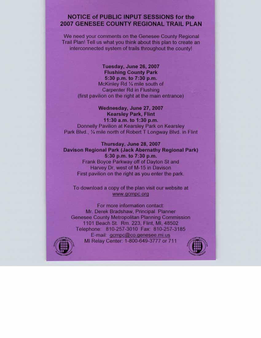
139
140
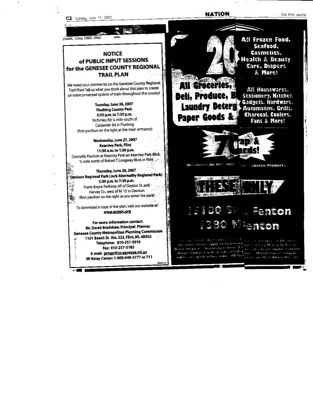
141
142
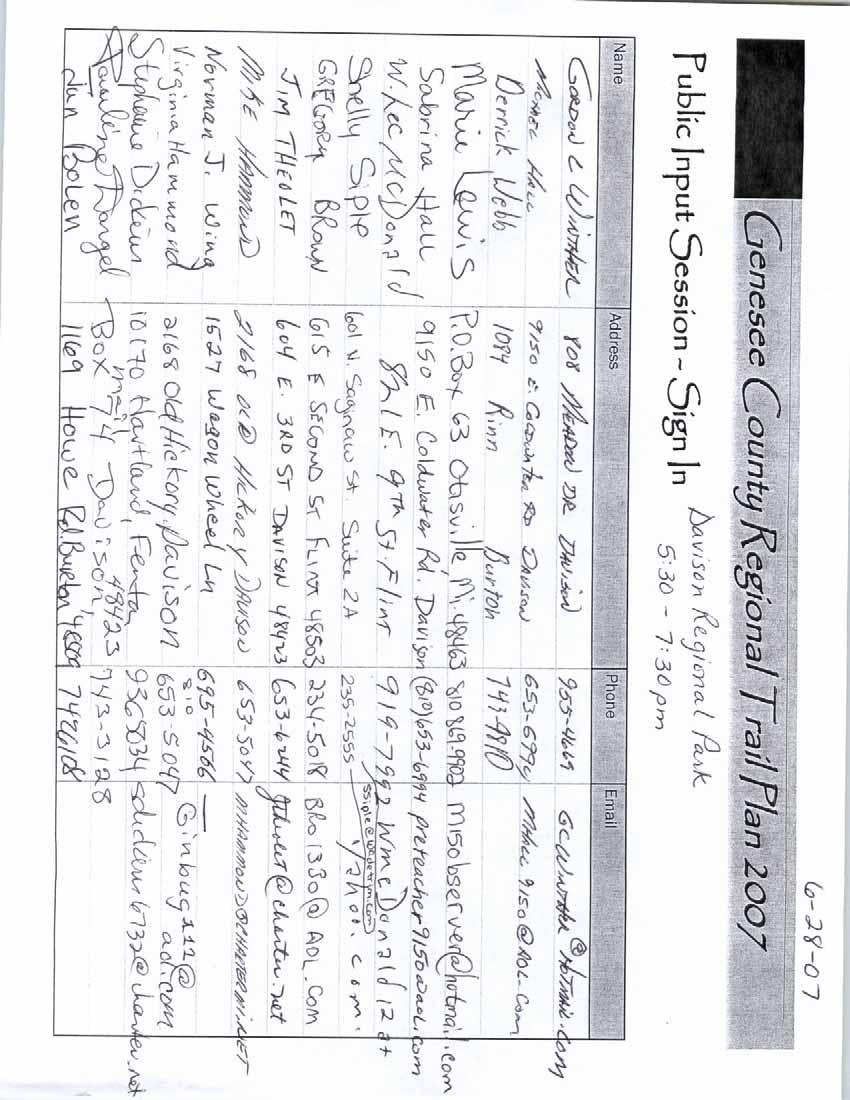
143
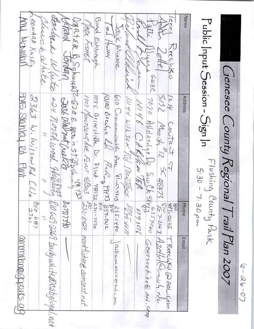
144
145
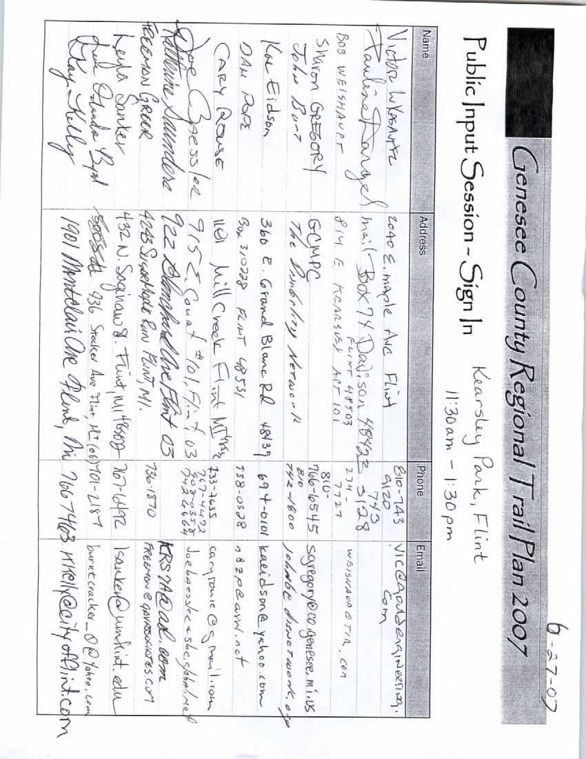
146
147
148
149
150
151
152
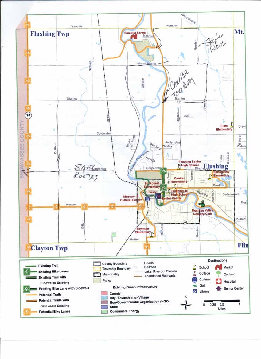
153
154
155
156
157
158
159
160
161
162
163
164
165
166
167
168
169
170
171
172
173
174
175
176
177
178
179
180
181
182
183
184
185
186
187
188
189
190
191
192
193
194
195
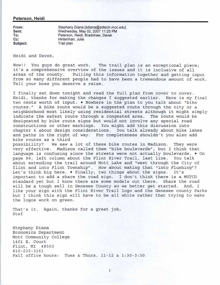
196
197
198
199

200
201
202
203
204
205

206

207
208
209
210
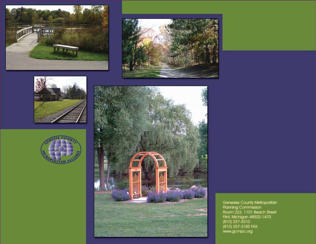
211
Non-Motorized Transportation
 Non-Motorized Transportation Non-motorized facilities are important components to the transportation system. They provide an environmentally-friendly, low-cost mode of travel. Some of the facilities can
University Region Non-Motorized Plan 2015
 Non-Motorized Transportation Non-motorized facilities are important components to the transportation system. They provide an environmentally-friendly, low-cost mode of travel. Some of the facilities can
Chapter 6. Action Program. Heart of the Lakes Area Recreation Plan
 Heart of the Lakes Area Recreation Plan 1. Design and construct the following trails (please see the following map): a. the Speedway Trail 1) primary pathway the main trail 2) secondary pathway the proposed
2. Goals and Policies. The following are the adopted Parks and Trails Goals for Stillwater Township:
 D. PARKS AND TRAILS 1. Introduction Stillwater Township s population is relatively low, with most residents living on rural residences on large lots. The need for active park space has been minimal in
Blueways: Rivers, lakes, or streams with public access for recreation that includes fishing, nature observation, and opportunities for boating.
 Parks, Open Space and Trails PRINCE WILLIAM COUNTY 2008 COMPREHENSIVE PLAN TRAILS PLAN CONTENTS The components of the trails plan are: Intent Definitions Goals, Policies, and Action Strategies Trails Map
Chapter 6: POLICY AND PROCEDURE RECOMMENDATIONS
 Chapter 6 POLICY AND PROCEDURE RECOMMENDATIONS FOR SRRA Below are seven policy elements that should be considered for adoption by the Southwest Regional Recreation Authority of Virginia: 1. Develop strategies
FEASIBILITY CRITERIA
 This chapter describes the methodology and criteria used to evaluate the feasibility of developing trails throughout the study areas. Land availability, habitat sensitivity, roadway crossings and on-street
Business Item No
 Metropolitan Parks and Open Space Commission Meeting date: February 6, 2018 For the Community Development Committee meeting of February 20, 2018 For the Metropolitan Council meeting of February 28, 2018
Section II. Planning & Public Process Planning for the Baker/Carver Regional Trail began in 2010 as a City of Minnetrista initiative.
 Section II Planning & Public Process Planning for the began in 2010 as a City of initiative. city staff began discussions with the Park District on the possibility of a north/south regional trail connection
Longmont to Boulder Regional Trail Jay Road Connection DRAFT FINAL REPORT
 Longmont to Boulder Regional Trail Jay Road Connection DRAFT FINAL REPORT December 2018 Project Summary Boulder County, Colorado, in partnership with the City of Boulder, is evaluating options for multi-use
MUNICIPALITY OF ANCHORAGE
 MUNICIPALITY OF ANCHORAGE ANCHORAGE PARKS & RECREATION Memorandum PRC 08-56 DATE: 5 August 2008 TO: FROM: SUBJECT: Parks & Recreation Commission Holly Spoth-Torres, Park Planner PRC 08-56 Far North Bicentennial
Auburn Trail / Ontario Pathways Trail Connector Feasibility Study Public Information Meeting Wednesday, August 22, 2012
 Auburn Trail / Ontario Pathways Trail Connector Feasibility Study Public Information Meeting Wednesday, August 22, 2012 Purpose of Feasibility Study Purpose Evaluate the feasibility of constructing a multiuse
Georgetown-Lewes Rail/Trail Study. Rail/Trail Study: Cool Spring to Cape Henlopen State Park New Road Extension (House Resolution No.
 Georgetown-Lewes Rail/Trail Study Rail/Trail Study: Cool Spring to Cape Henlopen State Park New Road Extension (House Resolution No. 47) August 22, 2011 Presentation Outline Background Benefits Statewide
Committee. Presentation Outline
 CW-33-15 11/9/2015 Community and Corporate Services Committee November 10, 2015 1 Presentation Outline Background Vision and Objectives Study Process and Timeline Public and Stakeholder Engagement Organization
Schoolcraft Township is located in northeast Houghton County. A portion of the township borders Keweenaw County and Lake Superior.
 COMMUNITY DESCRIPTION Schoolcraft Township is located in northeast Houghton County. A portion of the township borders Keweenaw County and Lake Superior. The township is largely rural but has one main population
The Baker/Carver Regional Trail is intended to
 Section V Design Guidance The Baker/Carver Regional Trail is intended to safely accommodate 183,000 annual visits, an array of non-motorized uses, a variety of skill levels, and persons with special needs.
Aviation, Rail, & Trucking 6-1
 6-1 This chapter describes the services, facilities, and condition of air, rail, and trucking as components of the transportation system. These three intermodal areas have an impact on the factors to be
The following trails completed their work utilizing funds awarded by the Greenways Foundation:
 The Greenways Foundation Grant Awards 2013 and 2014 Our grant program has been in place since 2012 and is funded entirely by the proceeds received through our Indiana BMV specialty license plate. Please
Regional Wayfinding Sign Strategy Thurston County Trails 2017
 Regional Wayfinding Sign Strategy Thurston County Trails 2017 Partners: Members and partnering organizations of the Thurston Thrives Community Design Action Team City of Lacey, City of Olympia, City of
INGHAM COUNTY TRAILS AND PARKS TASK FORCE MEETING 2
 INGHAM COUNTY TRAILS AND PARKS TASK FORCE MEETING 2 October 22, 2015 Mannik and Smith Group Michigan Trails & Greenways Alliance AGENDA FOR TONIGHT 1. Project Approach, Process and Timeframe 2. Public
NORTHEAST CARLTON COUNTY BICYCLE ROUTE PLAN
 NORTHEAST CARLTON COUNTY BICYCLE ROUTE PLAN 5/31/2014 and St. Louis River Trail Plan Update Produced by the Arrowhead Regional Development Commission (ARDC) in Partnership with the State Health Improvement
City of Haslett. City of East Lansing. City of East Lansing
 Central Park North (Nancy L. Moore Park) Lake Park North Expansion White Park Expansion #2 White Park Expansion #1 County East East Haslett East East TF87-212 Acquisition $90,000.00 Park. TF08-138 Acquisition
Montrose Charter Township Parks & Recreation Master Plan
 Montrose Charter Township Parks & Recreation Master Plan 2014-2018 Adopted February 25, 2014 Montrose Charter Township Parks & Recreation Master Plan 2014-2018 Montrose Charter Township 139 S. Saginaw
City of Durango 5.8 FUNDING TRAILS DEVELOPMENT
 5.8 FUNDING TRAILS DEVELOPMENT The City has been successful in establishing dedicated local funding sources as well as applying for grants to develop the City s trail system, having received nearly $2.4
DRAFT - APRIL 13, 2007 ROUTING STUDY FOR TRAIL CONNECTIONS BETWEEN CALAIS AND AYERS JUNCTION
 DRAFT - APRIL 13, 2007 ROUTING STUDY FOR TRAIL CONNECTIONS BETWEEN CALAIS AND AYERS JUNCTION Abstract The vision for the East Coast Greenway is an off-road urban trail system running from Calais, Maine
MASTER PLAN EXECUTIVE SUMMARY
 Biscuit Run State Park Scottsville Road (State Route 20) Charlottesville, VA 22902 Biscuit Run State Park MASTER PLAN EXECUTIVE SUMMARY Department of Conservation and Recreation Division of Planning and
Northeast Quadrant Distinctive Features
 NORTHEAST QUADRANT Northeast Quadrant Distinctive Features LAND USE The Northeast Quadrant includes all the area within the planning area that is east of Interstate 5 and to the north of State Route 44.
2016 Regional Transportation Alternatives Program (TAP) Grant Application
 Grant Application") 2016 Regional Transportation Alternatives Program (TAP) Grant Application PROJECT TITLE: Yelm-Tenino Trail Extension Feasibility Study TRPC use only GENERAL PROJECT INFORMATION Agency or Organization City
2016 Regional Transportation Alternatives Program (TAP) Grant Application PROJECT TITLE: Yelm-Tenino Trail Extension Feasibility Study TRPC use only GENERAL PROJECT INFORMATION Agency or Organization City
ANCLOTE COASTAL TRAIL ALTERNATIVES ANALYSIS STUDY
 ANCLOTE COASTAL TRAIL ALTERNATIVES ANALYSIS STUDY PASCO COUNTY MPO JULY 2015 PROJECT OVERVIEW... INTRODUCTION EXECUTIVE SUMMARY CONTEXT... TAMPA BAY AREA, PINELLAS, & PASCO COUNTY S MULTI-USE TRAIL PLANS
Committee Members: Page 1 of 6
 Auburn Trail/Ontario Pathways Trail Connector Feasibility Study Project Advisory Committee Meeting June 29, 2011 at 6:30 p.m. Canandaigua Town Hall Draft Minutes Committee Members: Ronald L. Brand, Director
MEETING MINUTES District 1 Trail Planning Meeting 1
 MEETING MINUTES District 1 Trail Planning Meeting 1 June 1, 2017 2:00 PM 3:30 PM City of Two Harbors 2:00 Introductions Attendees: Lisa Austin, MnDOT Bryan Anderson, MnDOT Jasna Hadzic-Stanek, MnDOT Justin
CHAPTER 3 PLANNING GOALS
 CHAPTER 3 PLANNING GOALS AND PUBLIC INPUT INTRODUCTION This portion of the Algonac Master Plan is intended to outline a course for action in achieving the community s vision for the future. Throughout
Hudson Highlands Fjord Trail Draft Master Plan. April 29, 2015
 Hudson Highlands Fjord Trail Draft Master Plan April 29, 2015 Agenda Route Overview Proposed Segment Results of Community Survey on that Segment Next Steps Municipal Endorsement Environmental Review Implementation
Citrus Heights Creek Corridor Trail Project Trail Advisory Group Field Trip #2 September 11, :00 11:00 am Trellis Hall, Citrus Heights
 September 11, 2013 9:00 11:00 am Trellis Hall, Citrus Heights Project Overview The City of Citrus Heights is studying the feasibility of establishing a multi use trail system within the City s 26 miles
PEMBERTON VALLEY RECREATIONAL TRAILS MASTER PLAN UPDATE Community Open House. April 2018
 PEMBERTON VALLEY RECREATIONAL TRAILS MASTER PLAN UPDATE Community Open House April 2018 Introductions Introductions Matt Bakker, BHA Project Coordinator Other Team Members: Liz Scroggins, Grey Owl Consulting
Baker/Carver Regional Trail master plan public review draft
 Baker/Carver Regional Trail master plan public review draft November 2014 the mission of Three Rivers Park District is to promote environmental stewardship through recreation and education in a natural
2014 STATEWIDE COMPREHENSIVE OUTDOOR RECREATION PLAN
 2014 STATEWIDE COMPREHENSIVE OUTDOOR RECREATION PLAN SUSTAINING COLORADO S OUTDOOR RECREATION FUTURE SECTION 1: INTRODUCTORY INFORMATION WHAT IS THE SCORP? The SCORP update is required every five years
Trail # NW Tuesday, June DESIGN. Provide an Review the Provide an. Project Goals: System system. wayfinding
 I. Welcome / Introductions Bethany Creek Trail #2 Segment 3 Neighborhood Meeting #1 Bethany Presbyterian Church 15505 NW Springville Road, Portland, OR 97229 Tuesday, June 26, 2018 @ 6:00PM Meeting Minutes
A CASE FOR COMPLETING THE JORDAN RIVER PARKWAY: A
 A CASE FOR COMPLETING THE JORDAN RIVER PARKWAY: A safe crossing at 9000 South and 850 West Proposed 9000 South Underpass Parkway Timeline Parkway, Trail, and Tourism Facts Blueprint Jordan River 1971 1973
Segment 2: La Crescent to Miller s Corner
 goal of the USFWS refuges is to conserve, protect and enhance fish, wildlife and plants and their habitats for the continuing benefit of the American people. Refuge lands are used largely for fishing,
Welcome to the Cross County Trail Public Input Session!
 Welcome to the Cross County Trail Public Input Session! Please sign in on the table below! What are we doing here? Camden County has proposed a bicycle and pedestrian trail spanning across the entire county.
Proposal to Redevelop Lower Kananaskis River-Barrier Lake. Bow Valley Provincial Park. Frequently Asked Questions
 Proposal to Redevelop Lower Kananaskis River-Barrier Lake Bow Valley Provincial Park Frequently Asked Questions What is being proposed? What are the details of the proposal? Where is the project area located?
4.0 Context for the Crossing Project
 4.0 Context for the Crossing Project This section provides background information about key features of the North Douglas Crossing project area, and opportunities and constraints. This information is important
Township Superintendent
 EMPLOYMENT OPPORTUNITY Township Superintendent Buena Vista Charter Township Township Superintendent BUENA VISTA CHARTER TOWNSHIP Buena Vista Charter Township, located in Saginaw County, Michigan, strives
EXECUTIVE SUMMARY FALL Introduction. Findings
 EXECUTIVE SUMMARY FALL 2004 Introduction Trails are one of the most popular and highly desirable recreational resources in communities of all sizes throughout the country. In addition to providing a safe
Rogue River Access and Management Plan Draft Alternatives
 Rogue River Access and Management Plan Draft Alternatives The Rogue River Access and Management Plan was initiated in December, 2011 and is being led by Jackson County Parks (JCP) and Oregon Department
The Vision for the San Juan Islands Scenic Byway
 The Vision for the San Juan Islands Scenic Byway 2 Judd Cove, Orcas Island, Courtesy of Kurt Thorson (kurtthorson.com) and San Juan County Land Bank Vision for the San Juan Islands Scenic Byway The San
Business Item No XXX. Proposed Action That the Metropolitan Council approve the Coon Creek Regional Trail Master Plan.
 Business Item No. 2015-XXX Metropolitan Parks and Open Space Commission Meeting date: July 7, 2015 For the Community Development Committee meeting of July 20, 2015 For the Metropolitan Council meeting
METROPOLITAN COUNCIL 390 North Robert Street, St. Paul, MN Phone (651) TDD (651)
 TDD (651)") DATE: March 27, 2012 METROPOLITAN COUNCIL 390 North Robert Street, St. Paul, MN 55101 Phone (651) 602-1000 TDD (651) 291-0904 TO: Metropolitan Parks and Open Space Commission FROM: Arne Stefferud, Planning
DATE: March 27, 2012 METROPOLITAN COUNCIL 390 North Robert Street, St. Paul, MN 55101 Phone (651) 602-1000 TDD (651) 291-0904 TO: Metropolitan Parks and Open Space Commission FROM: Arne Stefferud, Planning
CHAPTER FOUR: TRANSPORTATION
 CHAPTER FOUR: TRANSPORTATION Barron County Comprehensive Plan: Transportation Page 61 Background Transportation facilities have a significant influence on land use, development and quality of life for
Appendix 3. Greenway Design Standards. The Whitemarsh Township Greenway Plan
 Appendix 3 Greenway Design Standards This chapter discusses two design standards for the greenway types discussed above. First, trail design standards are presented together with trailhead facilities and
J. Recreation Plan of Conservation and Development. The Town of Hebron. Section 2. Preservation of Unique Assets. 1 P a g e
 The Town of Hebron Section 2 2014 Plan of Conservation and Development Preservation of Unique Assets J. Recreation Open spaces, parks, sports fields, and recreational programs are considered essential
4.19 Parks, Recreation, and Conservation Lands
 interchange would have on the Reed Paige Clark Homestead located on the north side of Stonehenge Road. Alternative D would also affect Palmer Homestead, E.F. Adams House, and Knapp Brothers Shoe Manufacturing
Becker County Trail Routing Feasibility Study
 2016 Becker County Trail Routing Feasibility Study CONNECTING DETROIT MOUNTAIN AND MOUNTAIN VIEW RECREATIONAL AREA TO THE HEARTLAND TRAIL BECKER COUNTY ULTEIG ENGINEERS Contents Acknowledgements...2 INTRODUCTION...3
CHAPTER 5. Chapter 5 Recreation Element
 CHAPTER 5 Recreation Element Chapter 5 Recreation Element The Recreation Element of the Meyers Area Plan is a supplement to the Recreation Element of the TRPA Regional Plan and the El Dorado County General
FINAL TESTIMONY 1 COMMITTEE ON RESOURCES UNITED STATES HOUSE OF REPRESENTATIVES. July 13, 2005 CONCERNING. Motorized Recreational Use of Federal Lands
 FINAL TESTIMONY 1 STATEMENT OF DALE BOSWORTH CHIEF Of the FOREST SERVICE UNITED STATES DEPARTMENT OF AGRICULTURE Before the SUBCOMMITTEE ON FORESTS AND FOREST HEALTH And the SUBCOMMITTEE ON NATIONAL PARKS,
Waukee Trailhead Public Art and Amenities Project
 Waukee - Trailhead Public Art and Amenities Project Sponsor Waukee Project Title Waukee Trailhead Public Art and Amenities Project Termini Description ( i.e. Park Avenue to 19th Street) NE Intersection
Port Gamble Shoreline Area Conceptual Trail Proposal
 The North Kitsap Trails Association is pleased to be a partner to the Kitsap Forest and Bay Project and assist Kitsap County, Forterra, Olympic Property Group, Great Peninsula Conservancy and the Port
Lake Erie Commerce Center Traffic Analysis
 LOCATION: East of NYS Route 5 at Bayview Road Town of Hamburg Erie County, New York PREPARED BY: Wendel Companies 140 John James Audubon Parkway Suite 200 Amherst, New York 14228 January 2012 i ii Table
EMPLOYMENT OPPORTUNITY. Police Chief. Buena Vista Charter Township
 EMPLOYMENT OPPORTUNITY Police Chief Buena Vista Charter Township Police Chief BUENA VISTA CHARTER TOWNSHIP Buena Vista Charter Township is located in Saginaw County, Michigan. The township strives to be
AGENDA ITEM 5 D WAKULLA ENVIRONMENTAL INSTITUTE (WEI) TRAIL FEASIBILITY STUDY
 TRAIL FEASIBILITY STUDY") March 19, 2018 AGENDA ITEM 5 D WAKULLA ENVIRONMENTAL INSTITUTE (WEI) TRAIL FEASIBILITY STUDY TYPE OF ITEM: Action STATEMENT OF ISSUE The Wakulla Environmental Institute (WEI) Trail is one of several trails
March 19, 2018 AGENDA ITEM 5 D WAKULLA ENVIRONMENTAL INSTITUTE (WEI) TRAIL FEASIBILITY STUDY TYPE OF ITEM: Action STATEMENT OF ISSUE The Wakulla Environmental Institute (WEI) Trail is one of several trails
Logo Department Name Agency Organization Organization Address Information 5700 North Sabino Canyon Road
 Logo Department Name Agency Organization Organization Address Information United States Forest Coronado National Forest 5700 North Sabino Canyon Road Department of Service Santa Catalina Ranger District
!" # $ % & % ' ( '' ) ) ) ) )
 ) ) ) )") !" #$% &% ' ( ')) ))) #% * % ) +#% *- *,% ) Trails Attract Business, Residents and Tourists National Association of Homebuilders 0% 20% 40% 60% % of What People Desired Exercise Facilities Proximity to
!" #$% &% ' ( ')) ))) #% * % ) +#% *- *,% ) Trails Attract Business, Residents and Tourists National Association of Homebuilders 0% 20% 40% 60% % of What People Desired Exercise Facilities Proximity to
Chapter 9 Recreation
 Chapter 9 Chapter 9 1.0 INTRODUCTION The Town of Littleton is within one of New England s most important recreation areas. More than three million people live within 100 miles of the area. Local residents
Wilds. Headwaters. Lakes. Oxbows. Falls
 56 5 4 3 Wilds Headwaters Lakes Oxbows Falls 57 Zones It could be said the on-the-ground essence of this master plan appears within the next 6 pages of this report. As we learned in the preceding Cultural
TART Trails, Inc. (231)
") TART Trail System TART Trails, Inc. www.traversetrails.org (231) 941-4300 Leelanau Trail Stretching 15 miles along a former railroad corridor, the TART-owned Leelanau Trail connects Traverse City and Suttons
TART Trail System TART Trails, Inc. www.traversetrails.org (231) 941-4300 Leelanau Trail Stretching 15 miles along a former railroad corridor, the TART-owned Leelanau Trail connects Traverse City and Suttons
The Recreational Trail along Cushing Park road has been a successful addition to the city
 The Recreational Trail along Cushing Park road has been a successful addition to the city Trails TRAILS, PATHS, ROUTES AND CONNECTORS Citizen input pointed to trails, paths, bike routes, and other non-motorized
Saginaw Charter Township Master Plan
 Saginaw Charter Township Master Plan Overview of Draft & Public Hearing August 20, 2014 230 South Washington Avenue Saginaw Michigan 48607 (989) 754-4717 www.spicergroup.com Saginaw Charter Township Master
Committee Report. Community Development Committee For the Metropolitan Council meeting of April 13, Business Item No.
 Committee Report Business Item No. 2016-48 Community Development Committee For the Metropolitan Council meeting of April 13, 2016 Subject: Harriet Island-South St. Paul Regional Trail Master Plan, Saint
Mohawk Hudson Bike Hike Trail Crossroad Connection Study
 Summary Report - April 21, 2003 Mohawk Hudson Bike Hike Trail Crossroad Connection Study Summary Report Introduction The Capital District Transportation Committee (CDTC), in partnership with Albany County,
PROJECTS. Otonabee South Monaghan. Active Transportation Master Plan Proposed Ultimate Network
 Otonabee South Monaghan Ultimate Network Otonabee-South Monaghan, located on the north shore of Rice Lake, is home to Lang Pioneer Village, Harold Town Conservation Area and numerous resorts that are major
Strengthening the Ontario Trails Strategy. Report on Consultations and the Environmental Bill of Rights Registry
 Strengthening the Ontario Trails Strategy Report on Consultations and the Environmental Bill of Rights Registry Purpose To report on the feedback and information received through the regional consultations,
Jefferson County Non-Motorized Transportation and Recreational Trails Plan 2010
 Chapter 8: Goals and objectives Plan Update: The following update presents general principles, goals, and objectives related to non-motorized transportation facilities as a component of the overall transportation
Chapter 2: Summary of Existing Open Space System
 Chapter 2: Summary of Existing Open Space System In 1976, the Wake County Board of Commissioners established the Wake County Parks and Recreation Department in order to provide park facilities and programs
Coast to Coast Connector Summit
 Project Partners Welcome to the Coast to Coast Connector Summit Winter Garden, Florida City Hall October 1, 2014 1 Why are we here? Objectives 1. Inform key stakeholders on the current state of the C2C
Glacial Lakes State Trail Master Plan Amendment Trail Extension into Downtown Willmar
 Glacial Lakes State Trail Master Plan Amendment Trail Extension into Downtown Willmar Minnesota Department of Natural Resources Division of Parks and Trails July 2012 Glacial Lakes State Trail Master Plan
Blue River Trail Master Plan JSA to Town Hall June 2004
 Blue River Trail Master Plan JSA to Town Hall June 2004 Prepared for: Silverthorne Town Council Silverthorne SPORT Committee Department of Recreation and Culture Silverthorne Public Works Silverthorne
Trail Towns Using Trail Systems To Leverage Place, Tourism, and Economic Development
 Trail Towns Using Trail Systems To Leverage Place, Tourism, and Economic Development Harry Burkholder, AICP Community Planner II 324 Munson Avenue Traverse City, MI 49686 231-929-3696 burkholder@liaa.org
Committee Report. Community Development Committee For the Metropolitan Council meeting of August 12, Business Item No.
 Committee Report Business Item No. 2015-168 Community Development Committee For the Metropolitan Council meeting of August 12, 2015 Subject: Coon Creek Regional Trail Master Plan, Anoka County Proposed
TRUCKEE TAHOE AIRPORT DISTRICT BOARD OF DIRECTOR STAFF REPORT
 AGENDA ITEM: 11 TRUCKEE TAHOE AIRPORT DISTRICT BOARD OF DIRECTOR STAFF REPORT AGENDA TITLE: MEETING DATE: January 24, 2018 PREPARED BY: NTPUD Agency Partnership Opportunity, Multi-Use Trailhead Access
Trail Feasibility Study
 VOLUSIA COUNTY MPO CITY OF NEW SMYRNA BEACH FINAL REPORT JUNE 30, 2009 Trail Feasibility Study What s inside? 1 Introduction 2 Project Purpose & Scope 3 Physical Inventory & Assessment of Right-of- Way
ALBANY-HUDSON ELECTRIC TRAIL FEASIBILITY STUDY. Final Report OCTOBER 2011
 ALBANY-HUDSON ELECTRIC TRAIL FEASIBILITY STUDY Final Report OCTOBER 2011 ALBANY-HUDSON ELECTRIC TRAIL FEASIBILITY STUDY Prepared for: Town of East Greenbush 225 Columbia Turnpike Rensselaer, New York 12144
Chapter eight. Parks and Recreation. Introduction. Crystal Lake Park District
 Chapter eight Parks and Recreation Introduction One of the indicators of quality of life in a city is the parks and recreation system. The City of Crystal Lake is fortunate to have an excellent parks and
IL 390 Station. Wood Dale Open House Summary 5/18/17
 Wood Dale Open House Summary 5/18/17 The first public open house for the Wood Dale Comprehensive Plan took place on May 18 th, 2017. The program was conducted as a fun community event and there were 216
Silver Lake Park An Environmental Jewel for the Citizens of Prince William County
 Silver Lake Park An Environmental Jewel for the Citizens of Prince William County The Prince William Park Authority Mission Statement states: The Prince William County Park Authority will create quality
PLANNING COMMISSION AGENDA REPORT May 10, Members of the Planning Commission. Joyce Parker-Bozylinski, Contract Planner
 PLANNING COMMISSION AGENDA REPORT May 10, 2007 TO: FROM: PROPOSAL: APPLICANT: RECOMMENDATION: Members of the Planning Commission Joyce Parker-Bozylinski, Contract Planner Approval of the Calabasas Trails
Trail Etiquette. Hours of Operation. Trail Accessibility
 Trail Guide The Elmhurst Park District, with 28 parks and over 460 acres of land, offers nearly six miles of paved or asphalt park trails and maintains an additional 3.6 miles of trails within Elmhurst.
Colorado Springs & Pikes Peak Region Destination Master Plan
 Colorado Springs & Pikes Peak Region Destination Master Plan Overview June 19, 2018 DESTINATION MASTER PLAN What is Destination Master Planning? Focus on infrastructure, facilities, services, attractions
The Future of the Road to Revolutions. A Battle Road Scenic Byway Public Forum November 9, 2010
 The Future of the Road to Revolutions A Battle Road Scenic Byway Public Forum November 9, 2010 Who is the Battle Road Scenic Byway? Four Towns: Arlington, Lexington, Lincoln, Concord Minute Man National
3.0 LEARNING FROM CHATHAM-KENT S CITIZENS
 3.0 LEARNING FROM CHATHAM-KENT S CITIZENS An important aspect in developing the Chatham-Kent Trails Master Plan was to obtain input from stakeholders and the general public. Throughout the course of the
Tallahassee-St. Marks Historic Railroad Trail
 Revitalizing a Historic Trail Designated as a National Recreation Trail, the 16-mile Tallahassee-St. Marks Historic Railroad Trail has been enjoyed by countless bicyclists, runners, and outdoor enthusiasts
11. Recreational Trails and Pathways Needs
 11. Recreational Trails and Pathways Needs Background Walking, biking, hiking, in-line skating, canoeing, and other trail- and pathway-related activities are important to Boiseans. This importance is demonstrated
Southwest Quadrant Distinctive Features
 SOUTHWEST QUADRANT Southwest Quadrant Distinctive Features LAND USE The 31.17 square mile Southwest Quadrant includes all the area within the planning area west of I-5 and south of the Sacramento River.
COPPER HERITAGE TRAIL CONCEPTUAL PLAN 2011
 COPPER HERITAGE TRAIL CONCEPTUAL PLAN 2011 A Proposed 40 Mile Non-Motorized Rail Trail Route Connecting The Historic Communities Of the Copper Country Prepared For: Western Upper Peninsula Health Department
Stage 2 ION: Light Rail Transit (LRT) from Kitchener to Cambridge
 from Kitchener to Cambridge") Stage 2 ION: Light Rail Transit (LRT) from Kitchener to Cambridge Public Consultation Centre (PCC) No. 3 Please Sign-in Cambridge City Hall November 21, 2017 2:00 to 8:00pm Preston Memorial Auditorium
Stage 2 ION: Light Rail Transit (LRT) from Kitchener to Cambridge Public Consultation Centre (PCC) No. 3 Please Sign-in Cambridge City Hall November 21, 2017 2:00 to 8:00pm Preston Memorial Auditorium
Frost Law Weight Restrictions
 Frost Law Weight Restrictions DATE: March 04, 2013 SUBJECT: Seasonal Weight Restrictions Effective 6 AM Monday, March 11, 2013, the Genesee County Road Commission will place seasonal weight and speed restrictions
PIONEER PARK. City of Des Peres Parks Master Plan. SWT Design 46 INTRODUCTION
 PIONEER PARK INTRODUCTION Pioneer Park is a 7 acre neighborhood park located east of Interstate 270 and south of Manchester Road along Tallie Road. The park is situated in a residential neighborhood with
This Executive Summary highlights the results of a multi-year planning process and includes recommendations of the New Jersey Trails Plan.
 Purpose and Scope The New Jersey Trails Plan presents a renewed vision, goals and strategic actions to help guide the efforts of all those who plan, build, operate and maintain New Jersey s trails. Building
Martinez General Plan 2035 White Paper TRAILS
 Martinez General Plan 2035 White Paper TRAILS November 2016 The Issue The draft Martinez General Plan 2035 and Draft Program Environmental Impact Report were released for public review on September 15,
1 PROJECT STATUS UPDATE 2 ND CONCESSION FROM BRISTOL ROAD TO DOANE ROAD TOWNS OF EAST GWILLIMBURY AND NEWMARKET
 Report No. 3 of the Regional Council Meeting of March 28, 2013 1 PROJECT STATUS UPDATE 2 ND CONCESSION FROM BRISTOL ROAD TO DOANE ROAD TOWNS OF EAST GWILLIMBURY AND NEWMARKET The recommends: 1. Receipt