Martinez General Plan 2035 White Paper TRAILS
|
|
|
- Lionel Douglas Clark
- 5 years ago
- Views:
Transcription


1 Martinez General Plan 2035 White Paper TRAILS November 2016
2 The Issue The draft Martinez General Plan 2035 and Draft Program Environmental Impact Report were released for public review on September 15, Members of the public and other interested agencies submitted comments on the draft General Plan and Draft EIR during the 45-day public review period. The City received approximately 125 letters from individuals, with nearly 50 letters requesting the City to include a hiking trail map in the General Plan that identifies the Alhambra Hills North-South trail as shown on the 1986 Alhambra Hills Specific Plan, as well as other existing and proposed trails within and adjacent to the City s planning area. The purpose of this white paper is to provide information on State requirements for the inclusion of trails in a general plan and outline options for the Council to consider in 1) identifying existing, planned and potential new trails in the General Plan, and 2) including policies and programs in the General Plan that support development of new trail segments. White Paper Purpose The purpose of the General Plan White Papers is to analyze and discuss policy issues that have been identified during public review of the draft Martinez General Plan 2035 and Draft Program Environmental Impact Report. Staff initially selected the White Paper topics and the City Council confirmed them on April 20, White Papers are intended to resolve significant policy options before the preparation of the final Environmental Impact Report and Planning Commission and City Council hearings on the full draft General Plan. Introduction A general plan is a city s road map for the future. It describes a community s long-term vision and sets forth goals, policies and programs to manage growth, direct land use decision making, and preserve the environment and character of the community. The State of California requires every city and county to have a general plan to guide future development, conserve resources, and provide for public welfare and safety. Local ordinances and other plans must be generally consistent with the general plan and applicable policies and programs. The general plan provides for the physical development of a city and of any land outside its boundaries, but within the Sphere of Influence, which, in the planning agency s judgement, bears relation to its planning. The draft Martinez General Plan identifies its planning area as the area within its Sphere of Influence (SOI), as shown in Figure 1. The SOI includes all lands within the City s jurisdiction as well as small areas within the Alhambra Valley and a larger area east of the City and north of Highway 4. With respect to identifying new trails in the City s General Plan, it is important to recognize that the General Plan should only propose new trails within the City s planning area. The Plan may show future trails that have been identified by a regional planning agency, such as the Contra Costa Transportation Authority or the East Bay Regional Park District. 2

3 Figure 1: Martinez City Limits and Sphere of Influence 3
4 The general plan must cover seven mandatory elements: land use, circulation, housing, conservation, open space, noise, and safety. In addition, local agencies may cover other topics of local concern. These elements may be organized in any way the local jurisdiction sees fit. The draft Martinez General Plan contains the following elements and chapters: Chapter 1 Chapter 2 Chapter 3 Chapter 4 Chapter 5 Chapter 6 Chapter 7 Chapter 8 Chapter 9 Chapter 10 Chapter 11 Introduction and Vision Land Use Element Open Space and Conservation Element Historic, Cultural, and Arts Element Parks, Community Facilities and Infrastructure Element Circulation Element Housing Element (separate document) Safety Element Noise and Air Quality Element Growth Management Element Appendices ANALYSIS Identification of Existing and Proposed Trails in the Draft General Plan Trails are primarily addressed in the Parks, Community Facilities and Utilities Element on pp. 5-9 to The section includes a short description of the trail system and its uses and benefits, as well as a goal, a policy, and ten implementing actions (the section on trails is attached to this white paper as Appendix A). As required by State law, the City s Circulation Element identifies the bicycle and pedestrian network available for transportation. The focus of the State requirement is to ensure that local jurisdictions plan for and provide a complete transportation network that connects residents to employment centers, community centers, schools, commercial districts, and transit stops. Some of the bicycle and pedestrian routes may also be considered trails, although recreation and access to open space is not the overriding consideration in the State s requirement for circulation elements. The City s Circulation Element contains the Countywide Bicycle and Pedestrian Plan map adopted by the Contra Costa Transportation Authority in This map (see Figure 2) identifies existing and proposed Class 1 facilities, which are multi-use pathways that provide a completely separated right-of-way for the exclusive use of bicycles and pedestrians with minimized cross flows of motorized traffic. Existing Class 1 facilities inventoried in the General Plan and shown on the map are: Benicia-Martinez Bike Path (Marina Vista Avenue to Park Road) Contra Costa Canal Trail (Muir Road to Chilpancingo Parkway [Martinez only]) Ferry Street (north of Marina Vista Avenue) North Court Street 4
, and proposed improvements, as described in the Circulation")
5 The map also identifies the Bay Area Ridge Trail and future Class 1 multi-use paths. The map could be revised to better reflect the existing Bay Area Ridge Trail, as shown in the Bay Area Ridge Trail Council s map (Figure 3), and proposed improvements, as described in the Circulation Element as follows: Phase 1: construct trail from existing staging area east along south edge of the Martinez Regional Shoreline to existing Shoreline Trail near Ferry Street. Relocate and repave parking lot; Phase 2: construct trail from Nejedley staging area on the Carquinez Scenic Drive to Berrellesa Street along the south side of UPRR ROW and improve existing trail along Berrellesa Street to Granger s Wharf parking lot and existing section of Bay Trail; Phase 3: construct new bicycle and pedestrian bridge over the UPRR tracks at North Court Street from the existing trail in the Martinez Regional Shoreline Park to the Escobar-Court Street intersection in downtown Martinez. Maps published by the Bay Area Ridge Trail Council do not show a planned extension connecting Mt. Wanda to Feeder Trail #1. However, the Bay Area Ridge Trail Council has stated its goal is to complete this link, as well as a link at Mococo Road connecting the Benicia-Martinez Bridge Bike Path to Marina Vista Avenue. The Bay Area Ridge Trail currently ends where the Mt. Wanda Trail meets privately-owned land. 5
 6")
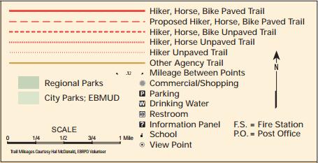
6 Figure 2: Bicycle Network from the Contra Costa Countywide Bicycle and Pedestrian Plan (2009) 6

7 Figure 3: Bay Area Ridge Trail Source: Bay Area Ridge Trail Council, Bay Area Ridge Trail Interactive Map, 7
8 State Requirement to Include Trails in the Open Space Element Government Code 65560(b) requires the open space element to include an inventory and map of parcels or areas of land or water within the planning area that are: 1) essentially unimproved, 2) identified on any local, regional or State open space plan, and 3) devoted to open space use for natural resources, the managed production of resources, outdoor recreation, public health and safety, and tribal resources. Subsection (b) further describes open space areas currently or planned for outdoor recreation use as follows: areas or outstanding scenic, historic and cultural value; areas particularly suited for park and recreation purposes, including access to lakeshores, beaches, and rivers and streams; and areas which serve as links between major recreation and open-space reservations, including utility easements, banks of rivers and streams, trails, and scenic highway corridors The Open Space and Conservation Element describes open spaces areas and provides a map of open space parcels identified on the City s Land Use map as agricultural lands, open space, or parks and recreation land, as well as visually sensitive lands (see Figure 3). Trails are not identified on this map, but, as described above, some are identified in the Contra Costa Countywide Bicycle and Pedestrian Plan map in the Circulation Element. Trails that link major recreation and open-space areas are the Bay Area Ridge Trail, the San Francisco Bay Trail, the California Riding and Hiking Trail, and the Juan Bautista de Anza National Historic Trail. These must be included on the General Plan Open Space Map. Inclusion of a Hiking Trail Map in the General Plan Although the General Plan does not identify proposed trails, the plan contains a number of programs that support and encourage the development of new trails, as follows: PCU-3.1a PCU-3.1b PCU-P-3.2 PCU-P-3.3 PCU-P-3.4 Establish priorities for funding for specific park or trailhead land through the Capital Improvement Program process. Consider purchasing land or accepting land dedication suitable for future trail development and recreational uses as land becomes available. Locate and construct new trails where access is easy to maximize their potential use and enjoyment by residents and visitors. Consider locating new trails within unused street rights-of-way (such as the Panoramic Drive paper street between Green Street and Thomas Drive). Incorporate trail development in the City s Capital Improvement Program (CIP). When considering development on parcels providing missing links in the planned trail system; Trails and connections should be incorporated into the development plan with a possible easement or dedication of public right-of-way when possible. 8
9 PCU-P-3.5 PCU-P-3.6 PCU-P-3.7 PCU-P-3.9 PCU-P-3.10 Work with the East Bay Regional Parks District (EBRPD), Contra Costa Water District, Contra Costa County, adjacent cities, regional trail groups, and other public agencies on trail planning issues, such as trail development and linkages. Construct trails according to the standards established by the California Trails Manual and EBRPD standards. Locate new trails with an emphasis on scenic qualities and making connections with local and regional open space areas, parks, points of interest and community facilities. When appropriate, encourage the public purchase of private lands for the preservation of open space ridge lines. Require future development within or upon ridgelines to include a condition of approval to provide access to and from or through the development via public trails. Beyond the requirement to describe and inventory transportation routes in the Circulation Element and trails that serve as links between major recreation and open space reservations in the Open Space Element, there is no State requirement to include a hiking trail map in the General Plan. Nonetheless, cities may include such a map and many choose to do so. There are several hiking maps published by various agencies and organizations that are readily available on the internet. These include a Mount Wanda hiking map published by the U.S. National Park Service ( see Figure 5) and maps published by the Bay Area Ridge Trail Council ( the San Francisco Bay Trail ( the Association of Bay Area Governments (Bay Trail) ( and the East Bay Regional Park District ( The Bay Area Ridge Trail Council, Bay Trail, and the East Bay Regional Park District also provide online interactive maps ( , and Several of these maps are attached in Appendix B. These sources provide more information than could be accommodated in a General Plan map, although they would provide a good starting point for developing a General Plan map at the appropriate level of detail. 9

10 Figure 3: Open Space Map 10
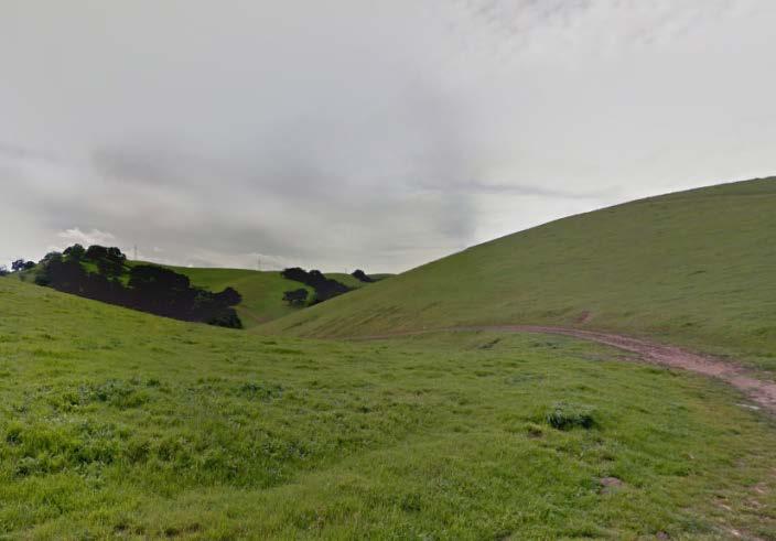
11 Proposed Trail Segments As discussed above, the City received nearly 50 letters requesting the General Plan include the Alhambra Hills North-South trail as shown on the 1986 Alhambra Hills Specific Plan on a General Plan hiking trails map. This proposed trail segment is discussed below. The City also received a more detailed letter from Jamie Fox on October 28, 2015, identifying existing and proposed trail segments that could be included in a hiking trails map in addition to the Alhambra Hills North-South trail. These trails are discussed in Appendix C. The requested Alhambra Hills North-South trail presumably is based on the Land Use and Circulation Figure in the 1986 Alhambra Hills Specific Plan (see Figure 4). That figure included a conceptual nature trail with potential trail segments for: 1) an east-west trail connecting Alhambra Avenue to Reilez Valley Rd; and 2) a north-south trail connecting Horizon Drive, Skyline Drive and Bernham Drive to the south, intersecting and joining the east-west trail for a short distance, and continuing to an emergency egress route with access to Wanda Way at the northern boundary of the plan area. Theses trail segments were intended to connect the developed areas of the plateau. Section of Specific Plan states: Public trail easements shall link the plateau area to surrounding development and the general plan riding and hiking trail system. Minimum connections shall include the California Riding and Hiking Trail to the east near MacAlvey Drive, Briones Regional Park, Golden Hills, the Foothills area and John Swett School. Recommended linkages are shown in Figure Trails shall be constructed by the developer when the City or other public agency will accept maintenance responsibility for the trail. In 1990, the Alhambra Highlands Residential Project was approved. The project was significantly reduced from the project envisioned in the Specific Plan. It included 216 dwelling units in three subdivisions covering a developable area of approximately 122 acres. Subsequently, the federal and State permit process resulted in necessary changes to the proposed project. In 2008, the property owner, Richfield Investment Corporation, filed applications to modify the 1990 project approvals. In April 2011, the City approved a new project for the Alhambra Highlands Planned Unit Development (#08-01). The new project includes 110 houses on 72 acres of the 297 acre site. Several of the sites will not be developed as envisioned in the Specific Plan, including Sites L, M and Q that were intended to be linked to the southern reach of the North-South trail. The approved project retains the east-west trail that connects Alhambra Avenue to Reliez Valley Road, as shown in the Landscape and Trail Plan of the 2011 Vesting Tentative Map, in essentially the same configuration as depicted in the Specific Plan (see Figure 5). The north-south trail, however, is not included. This occurred for a variety of reasons. First, as noted above, the removal of Sites L, M and Q from housing development precluded the need to link those sites to a trail system. The northern reach of the north-south trail was determined to be infeasible due to topographical and geotechnical constraints. There is an existing fire trail that provides access from Darley Way to the northern 11
12 boundary of the development area and the City limits, but there is currently no public access to Wanda Way, and since the roadway is located outside the City limits, the City has no jurisdictional control over this critical connection. In approving the Alhambra Highlands development in 2011, the City found the project consistent with both the General Plan and the Alhambra Hills Specific Plan. In particular, the City found the project consistent with Section of the Specific Plan, and noted: Within the limits of geotechnical constraints, the trail network as conceptually illustrated in Fig as shown on approved Landscape Improvement Plans is to be constructed by the developer, linking Alhambra Avenue to Horizon Drive and Reliez Valley road. The trail is to be built to East Bay Regional Park District standards and is to be maintained by the Alhambra Highlands Homeowner s Association or equivalent. As the Alhambra Highlands tentative map remains in effect, only those trails that were approved can be shown on a potential General Plan hiking trail map. This is necessary in order to maintain consistency between the General Plan and the approved vesting tentative map. However, the City is currently in negotiations with the property owner for a potential purchase of the property. If conditions change e.g., the property is sold to the City or a non-profit organization for open space and recreational use the General Plan hiking map, if adopted, could be amended to include new proposed trails within the Alhambra Hills planning area. 12

13 Figure 4: Land Use and Circulation Figure from the 1986 Alhambra Hills Specific Plan 13
")
14 Figure 5: Alhambra Hills Vesting Tentative Map Landscape and Trail Plan (annotated) 14
15 CONCLUSION A hiking trails map is not a State requirement for a general plan. However there are State requirements to describe and inventory transportation routes in the Circulation Element and trails that serve as links between major recreation and open space reservations in the Open Space Element. There are several agencies that provide detailed hiking trail maps and online interactive maps, including the Bay Area Ridge Trail Council, the East Bay Regional Park District, and the National Park Service. These sources provide more comprehensive information than what would typically be included in General Plan maps. CHANGES RECOMMENDED BY THE CONSULTANT AND INITIATED BY STAFF The General Plan consultant recommends the following changes be made to the draft General Plan: 1. In order to comply with State law, regional hiking trails that serve as links between major recreation and open-space reservations should be added to the Open Space map. These will include the Bay Area Ridge Trail, the San Francisco Bay Trail, the California Riding and Hiking Trail, and the Juan Bautista de Anza National Historic Trail. 2. The General Plan Bicycle Network map should be revised to accurately reflect the existing Bay Area Ridge Trail. Staff concurs with these changes and will make the revisions to the draft General Plan. GENERAL PLAN POLICY OPTIONS The General Plan consultant and City staff have identified the following options for the Planning Commission and City Council s consideration. These options and staff s analysis of the pros and cons of each option are discussed below. 1. Do nothing, other than the staff-initiated changes identified above. Pros: Would require the least amount of time and expense to revise the draft General Plan. Would avoid conflicts with other agencies published hiking trails maps. Would minimize future General Plan amendments needed to reflect changes in General Plan maps. Cons: Planners, decision makers, and community members would need to refer to other published maps to identify potential new trail segments and trail connections when reviewing development applications and planning for new recreation and circulation facilities and improvements. 2. Do not include a hiking trails map, but add a program to the General Plan to develop and adopt a Trails Master Plan as follows: 15
16 PCU-P-3.11: Consider preparation and adoption of a Trails Master Plan that inventories and maps existing, planned and proposed trails, trail segments and connections, identifies potential funding sources, and prioritizes trail segments for future development. Pros: Would allow time to develop a detailed hiking trails map with extensive community input. The Trails Master Plan could include planned, proposed and potential trails in addition to existing trails, and could include more detail about how, where and when to develop specific trails and linkages. Adding a program rather than creating a hiking trails map for the General Plan would mean that the General Plan could be adopted in a timely manner. The Trails Master Plan and associated maps would be easier to update and would not require a General Plan amendment whenever a revision is required. Cons: Would require funding to implement the program. 3. Add a hiking trails map to the General Plan. There are two alternatives under this option. Alternative A: Hiking Trails Map with Existing Trails: Add a hiking trails map that shows existing trails that are open to the public and have public access. Map trails as shown on hiking trail maps published by agencies and organizations with responsibility for the respective trail systems. Pros: Would help staff and decision makers to identify potential new trail segments and trail connections when reviewing development applications and planning for new recreation and circulation facilities and improvements. Would ensure consistency with other hiking maps and avoid conflicts with property owners. Cons: A map would add extra time and expense to development of a final draft General Plan. Alternative B: Hiking Trails Map with Existing and Proposed Trails. Add a hiking trails map to the General Plan that includes all existing trails identified under Alternative A as well as proposed trails that meet the following six conditions: 1) Are consistent with planned and proposed trails shown on regional maps published by agencies with responsibility for those trail systems (e.g., Bay Area Ridge Trail Council, Association of Bay Area Governments, the East Bay Regional Park District, and the National Park Service). 2) Are consistent with planned and proposed trail segments and improvements as described in adopted regional planning documents (e.g., Contra Costa Transportation Authority s 2009 Countywide Bicycle and Pedestrian Plan). 3) Are consistent with the approved vesting tentative map for the Alhambra Highlands and any other affected approved development. 4) Are wholly contained on land within the City limits and, if the land is likely to be annexed within the next 20 years, the City s Sphere of Influence. 5) Are on land that is owned by the City or other public agency. 16
17 Pros: Would ensure proposed trails are consistent with federal and regional maps, adopted regional and local plans, and approved development entitlements. Would ensure proposed trails are feasible for development and would avoid potential conflicts with existing property owners. Cons: A map would add extra time and expense to development of a final draft General Plan and most likely delay adoption of the General Plan. The General Plan would need to be amended whenever a trail is abandoned, reconfigured or added. This is unlikely to have much impact on existing trails, but it could mean multiple amendments to keep up with changes in proposed trails. STAFF RECOMMENDATION Based upon the pros and cons discussed above, City staff recommends the Planning Commission select policy option #2. This option would ensure that the General Plan update process may continue in the most timely and cost-effective manner, while providing for a community planning process to develop a Trails Master Plan. This option would also ensure that the General Plan remain a high-level planning document, while the details of trail planning, funding and development are worked out in a more flexible, subordinate planning document that may be updated in the future without a General Plan amendment. 17
18 Appendix A: Excerpt from the draft Martinez General Plan (pp. 5-9 to 5-11) Trails Trails are important to Martinez and provide significant opportunities for recreation throughout the City and surrounding areas. Hikers, bikers, and equestrian riders all share a need for trails, although their specific requirements for types of trails may vary. Trails provide recreational value associated with physical fitness and the enjoyment of the natural and scenic environment. Also, some trails provide safe, off-street links between neighborhoods, parks, schools, and other public facilities. The trails system provides access to public places and to scenic vistas that represent a significant natural amenity to the community. Where feasible, the proposed trails interconnect, providing a continuous trails system. Goals Policies and Implementation Programs for Trail Facilities Goal 2 PCU-G-3 An interconnected Trail System providing access to recreational opportunities should continue to be developed and enhanced as funding permits. Policy PCU-P-3.1 Improve trail connections within and beyond the City Limits and coordinate funding for trail acquisition, construction and maintenance, whenever feasible. Implementation PCU-3.1a PCU-3.1b PCU-P-3.2 PCU-P-3.3 PCU-P-3.4 Establish priorities for funding for specific park or trailhead land through the Capital Improvement Program process. Consider purchasing land or accepting land dedication suitable for future trail development and recreational uses as land becomes available. Locate and construct new trails where access is easy to maximize their potential use and enjoyment by residents and visitors. Consider locating new trails within unused street rights-of-way (such as the Panoramic Drive paper street between Green Street and Thomas Drive). Incorporate trail development in the City s Capital Improvement Program (CIP). When considering development on parcels providing missing links in the planned trail system; Trails and connections should be incorporated into the development plan with a possible easement or dedication of public right-of-way when possible. 18
19 PCU-P-3.5 PCU-P-3.6 PCU-P-3.7 PCU-P-3.9 PCU-P-3.10 Work with the East Bay Regional Parks District (EBRPD), Contra Costa Water District, Contra Costa County, adjacent cities, regional trail groups, and other public agencies on trail planning issues, such as trail development and linkages. Construct trails according to the standards established by the California Trails Manual and EBRPD standards. Locate new trails with an emphasis on scenic qualities and making connections with local and regional open space areas, parks, points of interest and community facilities. When appropriate, encourage the public purchase of private lands for the preservation of open space ridge lines. Require future development within or upon ridgelines to include a condition of approval to provide access to and from or through the development via public trails. 19

20 Appendix B: Hiking Trail Maps for Martinez Area Source: Bay Area Ridge Trail Council, 20

21 Source: Bay Area Ridge Trail Council, 21

22 Source: East Bay Regional Park District, 22

23 Source: East Bay Regional Park District, 23

24 Source: East Bay Regional Park District, 24

25 Source: Bay Area Trail Navigational Map, 25
26 Appendix C: Additional Proposed Trail Segments The following discusses existing and proposed trail segments that were included in a comment letter from Jamie fox on October 28, The map is included as Figure A. Staff annotated the map with numbers that refer to the segments identified below. Trail Segment 1: This proposed trail segment appears to run along the north side of Waterfront Road and the Southern Pacific railroad from the eastern end of the City limit line and connecting to the Bay Area Ridge Trail at the intersection of Marina Vista Avenue and Bridgehead Road. The segment is within the City boundaries. The trail segment is within the Environmental Conservation District- Heavy Industrial District (ECD-H-1) zoning district and traverses vacant and developed parcels with industrial uses. The CCTA s 2009 Countywide Bicycle and Pedestrian Plan map (see Figure 2) shows a proposed Class I multi-use path on Waterfront Road, which would make this proposed trail segment largely redundant. Trail Segment 2: This proposed trail segment would connect Trail Segment 1 described above to the Waterbird Regional Preserve trails, which are currently accessed from a parking lot off Waterbird Way. Most, if not all, of the trail segment would be developed on land outside the City limit line but within the City s Sphere of Influence. As described above, the proposed multi-use path on Waterfront Road would provide access to Waterbird Way, although not a separate Class 1 facility along the 0.2 mile roadway to the Waterbird Regional Preserve parking lot. Trail Segment 3: This segment appears to run along the north side of the Southern Pacific Railroad, although it is marked as the Bay Ridge Trail, which officially runs along Marin Vista Avenue and Escobar Street until it reaches Talbart Street and the Carquniez Scenic Drive. Parcels along the eastern end of the proposed segment are in the Heavy Industrial zoning district and are currently in industrial use. As proposed, the trail would need to cross the railroad tracks and run through these industrial parcels before connecting to a new trail extension through Waterfront Park. Trail Segment 4: This trail segment is identified as a Bay Area Ridge trail connection from the Martinez Regional Shoreline to what appears to be the Nejedly/East Staging Area on the Carquinez Scenic Drive. However, as discussed above, the Bay Area Ridge Trail does not officially run through Martinez Regional Shoreline. As proposed, the trail segment would need to cross the railroad tracks in this location. As described in the Circulation Element, the Countywide Bicycle and Pedestrian Plan contains the following improvements to close existing Bay Trail gaps in this area: Phase 1: construct trail from existing staging area east along south edge of the Martinez Regional Shoreline to existing Shoreline Trail near Ferry Street. Relocate and repave parking lot; Phase 2: construct trail from Nejedley staging area on the Carquinez Scenic Drive to Berrellesa Street along the south side of UPRR ROW and improve existing trail along Berrellesa Street to Granger s Wharf parking lot and existing section of Bay Trail; 26
")
27 Figure A: Hiking Trail Map Submitted by Jamie Fox, October 28, 2015 (numbers added by staff for discussion purposes) 27
28 Phase 3: construct new bicycle and pedestrian bridge over the UPRR tracks at North Court Street from the existing trail in the Martinez Regional Shoreline Park to the Escobar-Court Street intersection in downtown Martinez. Trail Segment 5: The segment appears to begin near the Brown Street/Ferry Street intersection and run south to the Vista Oaks Drive area. This trail would apparently traverse multiple, privately-owned lots zoned for and developed with housing. Trail Segment 6: This is a proposed extension of the Bay Area Ridge Trail, which currently ends at Mt. Wanda near the Martinez city limit line. The segment would apparently connect Mt. Wanda to Feeder Trail #1 as it passes through the Sky Ranch Muir Heritage Land Trust. Segment 6 is outside the City s Sphere of Influence and traverses land in private ownership and zoned for agricultural preserve (APN ) and dry farming, grazing and pasturing (APN ). The trail segment is identified as a gap on the Bay Area Ridge Trail Council maps, with no planned trail crossing the privately-owned land. Trail Segment 7: This proposed trail is also largely outside the City s Sphere of Influence. It would apparently connect proposed Trail Segment 6 to Stone View Court. Most of the land passes through land in private ownership as described above (APN ). The parcels adjacent to Stone View Court are in private ownership and are developed with single family homes. Trail Segment 8: This proposed trail is within the City s Sphere of Influence, but part of it runs through land owned by the U.S. National Park Service. It would apparently wrap around the southwestern flank of Mt. Wanda, connecting the Mount Wanda Trails of the John Muir National Historic Site (see Figure B) to Alhambra Valley Road. The other section of the proposed trail is outside the City limits and traverses a privately-owned parcel in the Alhambra Valley Autonomous Region. The parcel is zoned for dry farming, grazing and pasturing (APN ). Trail Segment 9: This proposed trail segment apparently runs along the west side of Alhambra Avenue and Alhambra Valley Road, from Highway 4 to the north to Sheridan Lane in the unincorporated Alhambra Valley Autonomous Region. The trail could run within the right-of-way, but it would be challenging to connect it the Mount Wanda trail as shown in Figure B as this is within the National Park Service land. The proposed trail appears to traverse privately-owned parcels developed with single family homes at the southern end. Trail Segment 10: This proposed trail segment is within the City s SOI, but the western end of it passes through the unincorporated Alhambra Valley Autonomous Region. This section apparently would run along the discontinuous Deodora Way and Sequoia Way, but further access to the east would require traversing privately-owned property zoned for residential use (one parcel is developed with a single family home and the other is vacant). The remaining sections of this proposed trail are within the City s limits and the Alhambra Hills Specific Plan area. The proposed trail system appears to be based upon the Land Use and Circulation figure in the 1986 Alhambra Hills Specific Plan and is discussed in the body of the white paper. 28

29 Figure B: Mount Wanda Trails of the John Muir National Historic Site 29
FEASIBILITY CRITERIA
 This chapter describes the methodology and criteria used to evaluate the feasibility of developing trails throughout the study areas. Land availability, habitat sensitivity, roadway crossings and on-street
Airport Planning Area
 PLANNING AREA POLICIES l AIRPORT Airport Planning Area LOCATION AND CONTEXT The Airport Planning Area ( Airport area ) is a key part of Boise s economy and transportation network; it features a multi-purpose
MONTEREY REGIONAL AIRPORT MASTER PLAN TOPICAL QUESTIONS FROM THE PLANNING ADVISORY COMMITTEE AND TOPICAL RESPONSES
 MONTEREY REGIONAL AIRPORT MASTER PLAN TOPICAL QUESTIONS FROM THE PLANNING ADVISORY COMMITTEE AND TOPICAL RESPONSES Recurring topics emerged in some of the comments and questions raised by members of the
Blueways: Rivers, lakes, or streams with public access for recreation that includes fishing, nature observation, and opportunities for boating.
 Parks, Open Space and Trails PRINCE WILLIAM COUNTY 2008 COMPREHENSIVE PLAN TRAILS PLAN CONTENTS The components of the trails plan are: Intent Definitions Goals, Policies, and Action Strategies Trails Map
Section II. Planning & Public Process Planning for the Baker/Carver Regional Trail began in 2010 as a City of Minnetrista initiative.
 Section II Planning & Public Process Planning for the began in 2010 as a City of initiative. city staff began discussions with the Park District on the possibility of a north/south regional trail connection
Longmont to Boulder Regional Trail Jay Road Connection DRAFT FINAL REPORT
 Longmont to Boulder Regional Trail Jay Road Connection DRAFT FINAL REPORT December 2018 Project Summary Boulder County, Colorado, in partnership with the City of Boulder, is evaluating options for multi-use
AGENDA ITEM 5 D WAKULLA ENVIRONMENTAL INSTITUTE (WEI) TRAIL FEASIBILITY STUDY
 TRAIL FEASIBILITY STUDY") March 19, 2018 AGENDA ITEM 5 D WAKULLA ENVIRONMENTAL INSTITUTE (WEI) TRAIL FEASIBILITY STUDY TYPE OF ITEM: Action STATEMENT OF ISSUE The Wakulla Environmental Institute (WEI) Trail is one of several trails
March 19, 2018 AGENDA ITEM 5 D WAKULLA ENVIRONMENTAL INSTITUTE (WEI) TRAIL FEASIBILITY STUDY TYPE OF ITEM: Action STATEMENT OF ISSUE The Wakulla Environmental Institute (WEI) Trail is one of several trails
2. Goals and Policies. The following are the adopted Parks and Trails Goals for Stillwater Township:
 D. PARKS AND TRAILS 1. Introduction Stillwater Township s population is relatively low, with most residents living on rural residences on large lots. The need for active park space has been minimal in
Georgetown-Lewes Rail/Trail Study. Rail/Trail Study: Cool Spring to Cape Henlopen State Park New Road Extension (House Resolution No.
 Georgetown-Lewes Rail/Trail Study Rail/Trail Study: Cool Spring to Cape Henlopen State Park New Road Extension (House Resolution No. 47) August 22, 2011 Presentation Outline Background Benefits Statewide
EXECUTIVE SUMMARY FALL Introduction. Findings
 EXECUTIVE SUMMARY FALL 2004 Introduction Trails are one of the most popular and highly desirable recreational resources in communities of all sizes throughout the country. In addition to providing a safe
CHAPTER 4 -- THE LAND USE PLAN: DESCRIPTIONS AND POLICIES FOR THIRTEEN PLANNING AREAS
 CHAPTER 4 -- THE LAND USE PLAN: DESCRIPTIONS AND POLICIES FOR THIRTEEN PLANNING AREAS NORTH CENTRAL CAC AREA LITTLE VALLEY ROAD TO JUG HANDLE CREEK PLANNING AREA This planning area includes Cleone, Noyo,
CHAPTER 1 INTRODUCTION MORENO VALLEY GENERAL PLAN 1. INTRODUCTION. 1.1 What is a General Plan?
 1. INTRODUCTION 1.1 What is a General Plan? A General Plan is a comprehensive long-term strategy for the physical development of a city. It determines how land may be used and the infrastructure and public
COASTAL CONSERVANCY. Staff Recommendation December 2, 2004 COYOTE HELLYER COUNTY PARK BAY AREA RIDGE TRAIL
 COASTAL CONSERVANCY Staff Recommendation December 2, 2004 COYOTE HELLYER COUNTY PARK BAY AREA RIDGE TRAIL File No. 04-057 Project Manager: Amy Hutzel RECOMMENDED ACTION: Authorization to disburse up to
LUDLAM TRAIL CORRIDOR DISTRICT
 1 APPLICATION NO. 9 MAY 2015 CDMP CYCLE LUDLAM TRAIL CORRIDOR DISTRICT PLANNING ADVISORY BOARD November 2, 2015 BACKGROUND 2 Staff Application Former Florida East Coast railroad corridor (privately owned)
Mohawk Hudson Bike Hike Trail Crossroad Connection Study
 Summary Report - April 21, 2003 Mohawk Hudson Bike Hike Trail Crossroad Connection Study Summary Report Introduction The Capital District Transportation Committee (CDTC), in partnership with Albany County,
Economic Development and Tourism
 SECTION 4 SECTION 4 Economic Development and Tourism 4. Economic Development and Tourism Tourism plays a very important role in Niagara s economy, providing employment and generating business for support
Welcome to the Cross County Trail Public Input Session!
 Welcome to the Cross County Trail Public Input Session! Please sign in on the table below! What are we doing here? Camden County has proposed a bicycle and pedestrian trail spanning across the entire county.
Chatsworth Branch Library Devonshire Street, Chatsworth, CA Thursday, November 16, :00-8:00 pm
 Chatsworth Branch Library 21052 Devonshire Street, Chatsworth, CA 91311 Thursday, November 16, 2017 6:00-8:00 pm Project Team County of Los Angeles Department of Parks and Recreation Kathline King Chief
APPENDIX OFFICIAL MAP ORDINANCE OF HAMILTONBAN TOWNSHIP OFFICIAL MAP NARRATIVE
 APPENDIX A OFFICIAL MAP ORDINANCE OF HAMILTONBAN TOWNSHIP OFFICIAL MAP NARRATIVE INTRODUCTION: The Official Map of Hamiltonban Township has been prepared to identify those lands and features that Hamiltonban
Stevenson Ranch Library The Old Road, Stevenson Ranch, CA Thursday, November 9, :00-8:00 pm
 Stevenson Ranch Library 25950 The Old Road, Stevenson Ranch, CA 91381 Thursday, November 9, 2017 6:00-8:00 pm Project Team County of Los Angeles Department of Parks and Recreation Kathline King Chief of
COASTAL CONSERVANCY. Staff Recommendation September 22, 2011 BAY AREA RIDGE TRAIL: HOOD MOUNTAIN TO HIGHWAY 12
 COASTAL CONSERVANCY Staff Recommendation September 22, 2011 BAY AREA RIDGE TRAIL: HOOD MOUNTAIN TO HIGHWAY 12 File No. 11-039-001 Project Manager: Betsy Wilson RECOMMENDED ACTION: Authorization to disburse
ROAD AND TRAIL PROJECT APPROVAL
 ROAD AND TRAIL PROJECT APPROVAL www.marincountyparks.org Marin County Parks, 3501 Civic Center Dr, Suite 260, San Rafael, CA 94903 DATE: July 12, 2017 PRESERVE: Gary Giacomini Open Space Preserve PROJECT:
EXECUTIVE SUMMARY PROGRAM DEVELOPMENT REPORT PURPOSE EXISTING SETTING EXPANDING PARKLAND
 EXECUTIVE SUMMARY PROGRAM DEVELOPMENT REPORT PURPOSE As the culmination of the first phase of the master planning process, this Program Development Report creates the framework to develop the Calero County
Parkland County Municipal Development Plan Amendment Acheson Industrial Area Structure Plan
 Parkland County Municipal Development Plan Amendment Acheson Industrial Area Structure Plan New Plan Acheson Industrial Area Structure Plan Amendment Parkland County Municipal Development Plan Board Reference
The Chu property is a 6.57 acre parcel located in the Town of Superior on the west side of McCaslin Boulevard. In 2014, the Town of Superior acquired
 1 The Chu property is a 6.57 acre parcel located in the Town of Superior on the west side of McCaslin Boulevard. In 2014, the Town of Superior acquired the Chu property for open space with a contribution
PLANNING COMMISSION AGENDA REPORT May 10, Members of the Planning Commission. Joyce Parker-Bozylinski, Contract Planner
 PLANNING COMMISSION AGENDA REPORT May 10, 2007 TO: FROM: PROPOSAL: APPLICANT: RECOMMENDATION: Members of the Planning Commission Joyce Parker-Bozylinski, Contract Planner Approval of the Calabasas Trails
HIGHWAY 17 WILDLIFE and REGIONAL TRAIL CROSSINGS
 HIGHWAY 17 WILDLIFE and REGIONAL TRAIL CROSSINGS Agenda and Meeting Format 7:00-7:15 Welcome 7:15-8:00 Presentation 8:00-8:30 Open House 8:30 Recap 9:00 Conclusion 2 Meeting Goals: Introduce the project
A CASE FOR COMPLETING THE JORDAN RIVER PARKWAY: A
 A CASE FOR COMPLETING THE JORDAN RIVER PARKWAY: A safe crossing at 9000 South and 850 West Proposed 9000 South Underpass Parkway Timeline Parkway, Trail, and Tourism Facts Blueprint Jordan River 1971 1973
Continental Divide National Scenic Trail Legislative History and Planning Guidance
 Continental Divide National Scenic Trail Legislative History and Planning Guidance Legislation, Policy, and Direction Regarding National Scenic Trails The National Trails System Act, P.L. 90-543, was passed
MEETING MINUTES District 1 Trail Planning Meeting 1
 MEETING MINUTES District 1 Trail Planning Meeting 1 June 1, 2017 2:00 PM 3:30 PM City of Two Harbors 2:00 Introductions Attendees: Lisa Austin, MnDOT Bryan Anderson, MnDOT Jasna Hadzic-Stanek, MnDOT Justin
Trails. Lois Jensen Nature Preserve is a 30 acre parcel on the north end of the city. It provides unspoiled wooded paths.
 Trails Lois Jensen Nature Preserve is a 30 acre parcel on the north end of the city. It provides unspoiled wooded paths. TRAIL S, PATHS, ROUTES AND CONNECTORS Citizen input pointed to trails, paths, bike
DRAFT - APRIL 13, 2007 ROUTING STUDY FOR TRAIL CONNECTIONS BETWEEN CALAIS AND AYERS JUNCTION
 DRAFT - APRIL 13, 2007 ROUTING STUDY FOR TRAIL CONNECTIONS BETWEEN CALAIS AND AYERS JUNCTION Abstract The vision for the East Coast Greenway is an off-road urban trail system running from Calais, Maine
SUMMER VILLAGE OF SILVER SANDS. Municipal Development Plan
 SUMMER VILLAGE OF SILVER SANDS Municipal Development Plan Bylaw 253-2014 Adopted August 22, 2014 Summer Village of Silver Sands Municipal Development Plan Bylaw No. 253-2014 Page 2 1 INTRODUCTION 1.1 SETTING
11. Recreational Trails and Pathways Needs
 11. Recreational Trails and Pathways Needs Background Walking, biking, hiking, in-line skating, canoeing, and other trail- and pathway-related activities are important to Boiseans. This importance is demonstrated
The Recreational Trail along Cushing Park road has been a successful addition to the city
 The Recreational Trail along Cushing Park road has been a successful addition to the city Trails TRAILS, PATHS, ROUTES AND CONNECTORS Citizen input pointed to trails, paths, bike routes, and other non-motorized
Community Development Committee
 C Community Development Committee For the Metropolitan Council meeting of October 31, 2012 Committee Report Item:2012-316 ADVISORY INFORMATION October 16, 2012 Date Prepared: Subject: Intercity Regional
Business Item No XXX. Proposed Action That the Metropolitan Council approve the Coon Creek Regional Trail Master Plan.
 Business Item No. 2015-XXX Metropolitan Parks and Open Space Commission Meeting date: July 7, 2015 For the Community Development Committee meeting of July 20, 2015 For the Metropolitan Council meeting
STAFF REPORT. Airport Land Use Plan Consistency Review: Santa Barbara Airport Master Plan. MEETING DATE: November 19, 2015 AGENDA ITEM: 7D
 STAFF REPORT SUBJECT: Airport Land Use Plan Consistency Review: Santa Barbara Airport Master Plan MEETING DATE: AGENDA ITEM: 7D STAFF CONTACT: Peter Imhof, Andrew Orfila RECOMMENDATION: Adopt findings
STAFF REPORT. Airport Land Use Consistency Determination Betteravia Plaza. MEETING DATE: January 21, 2016 AGENDA ITEM: 8D
 STAFF REPORT SUBJECT: Airport Land Use Consistency Determination Betteravia Plaza MEETING DATE: AGENDA ITEM: 8D STAFF CONTACT: Andrew Orfila RECOMMENDATION: Adopt findings for the Betteravia Plaza project
S Central Coast Heritage Protection Act APRIL 21, 2016
 STATEMENT OF GLENN CASAMASSA ASSOCIATE DEPUTY CHIEF, NATIONAL FOREST SYSTEM U.S. FOREST SERVICE U.S. DEPARTMENT OF AGRICULTURE BEFORE THE UNITED STATES SENATE COMMITTEE ON ENERGY AND NATURAL RESOURCES
RE: Access Fund Comments on Yosemite National Park Wilderness Stewardship Plan, Preliminary Ideas and Concepts
 September 30, 2016 Superintendent Yosemite National Park Attn: Wilderness Stewardship Plan P.O. Box 577 Yosemite, CA 95389 RE: Access Fund Comments on Yosemite National Park Wilderness Stewardship Plan,
San Francisco, California Hunters Point Shipyard. Design for Development
 San Francisco, California Hunters Point Shipyard Design for Development San Francisco, California Hunters Point Shipyard Design for Development Adopted June 3, 2010 by: San Francisco Planning Commission
This page has been intentionally left blank.
 This page has been intentionally left blank. Chapter 2 2-2 2. Growing the Economy In many ways, the Niagara Region is a community of communities and this is becoming increasingly so. It is made up of towns
Classifications, Inventory and Level of Service
 Classifications, Inventory and Level of Service Section 3 Kenmore Park, Recreation and Open Space Plan 1 P a g e Classifications and Inventory Park Classifications Kenmore classifies its parks based upon
MESA COUNTY DEPARTMENT OF PUBLIC WORKS Administration - Building - Engineering Road and Bridge Traffic - Planning - Solid Waste Management
 MESA COUNTY DEPARTMENT OF PUBLIC WORKS Administration - Building - Engineering Road and Bridge Traffic - Planning - Solid Waste Management 200 S. Spruce St. P.O. Box 20,000 Grand Junction, Colorado 81502-5022
Landscaping & Lighting Districts (LLDs) and Zones of Benefit (ZOB)
 and Zones of Benefit (ZOB)") Landscaping & Lighting Districts (LLDs) and Zones of Benefit (ZOB) Summary Alameda County/Contra Costa County LLD (ACC-1) known as the Two County LLD 1993/1996 Six Zones of Benefit 1994-2007 - Now the
Landscaping & Lighting Districts (LLDs) and Zones of Benefit (ZOB) Summary Alameda County/Contra Costa County LLD (ACC-1) known as the Two County LLD 1993/1996 Six Zones of Benefit 1994-2007 - Now the
City of Chelan Shoreline Public Access Plan
 City of Shoreline Public Access Plan This City of Shoreline Public Access Plan documents how the City has planned for parks and recreation in the community, particularly along Lake and the River. This
SAN FRANCISCO MUNICIPAL TRANSPORTATION AGENCY
 THIS PRINT COVERS CALENDAR ITEM NO. : 10.4 DIVISION: Sustainable Streets BRIEF DESCRIPTION: SAN FRANCISCO MUNICIPAL TRANSPORTATION AGENCY Approving various parking and traffic modifications associated
Ontario Municipal Board Commission des affaires municipales de l Ontario
 Commission des affaires municipales de l Ontario ISSUE DATE: July 25, 2014 CASE NO: PL130788 PROCEEDING COMMENCED UNDER subsection 17(36) of the Planning Act, R.S.O. 1990, c. P.13, as amended Subject:
COASTAL CONSERVANCY. Staff Recommendation November 6, 2008 SAN FRANCISCO BAY TRAIL: CANAL BOULEVARD CONSTRUCTION
 COASTAL CONSERVANCY Staff Recommendation November 6, 2008 SAN FRANCISCO BAY TRAIL: CANAL BOULEVARD CONSTRUCTION File No. 07-037-02 Project Manager: Michelle Jesperson RECOMMENDED ACTION: Authorization
DEPARTMENT OF PLANNING, COMMUNITY & ECONOMIC DEVELOPMENT
 DEPARTMENT OF PLANNING, COMMUNITY & ECONOMIC DEVELOPMENT DATE: December 11, 2015 TO: FROM: SUBJECT: City Council Kevin Cricchio, AICP Associate Planner Department of Planning, Community & Economic Development
MASTER PLAN EXECUTIVE SUMMARY
 Biscuit Run State Park Scottsville Road (State Route 20) Charlottesville, VA 22902 Biscuit Run State Park MASTER PLAN EXECUTIVE SUMMARY Department of Conservation and Recreation Division of Planning and
Portneuf Greenway Trail System
 Portneuf Greenway Trail System The purpose of this Master Plan is to outline the vision for the development of the Portneuf Greenway Trail System Master Plan Approved BTPO January 5, 2009 Table of Contents
4.19 Parks, Recreation, and Conservation Lands
 interchange would have on the Reed Paige Clark Homestead located on the north side of Stonehenge Road. Alternative D would also affect Palmer Homestead, E.F. Adams House, and Knapp Brothers Shoe Manufacturing
4.0 Context for the Crossing Project
 4.0 Context for the Crossing Project This section provides background information about key features of the North Douglas Crossing project area, and opportunities and constraints. This information is important
Alternatives Analysis City of Newport Beach Sunset Ridge Park Project December 14, 2011
 Alternatives Analysis City of Newport Beach Sunset Ridge Park Project December 14, 2011 Alternatives Analysis for Vehicular Access: This report supplements the project s certified EIR s Alternatives Analysis.
METROPOLITAN COUNCIL 390 North Robert Street, St. Paul, MN Phone (651) TDD (651)
 TDD (651)") DATE: March 27, 2012 METROPOLITAN COUNCIL 390 North Robert Street, St. Paul, MN 55101 Phone (651) 602-1000 TDD (651) 291-0904 TO: Metropolitan Parks and Open Space Commission FROM: Arne Stefferud, Planning
DATE: March 27, 2012 METROPOLITAN COUNCIL 390 North Robert Street, St. Paul, MN 55101 Phone (651) 602-1000 TDD (651) 291-0904 TO: Metropolitan Parks and Open Space Commission FROM: Arne Stefferud, Planning
North Forty Area ( area bounded by Lark Avenue, Los Gatos Boulevard, Highway 85 and
 RESOLUTION 2015-056 RESOLUTION OF THE TOWN COUNCIL OF THE TOWN OF LOS GATOS ADOPTING GENERAL PLAN AMENDMENTS NECESSARY FOR THE NORTH FORTY SPECIFIC PLAN. THE PLAN AREA COMPRISES APPROXIMATELY 44 ACRES
ARLINGTON COUNTY, VIRGINIA
 ARLINGTON COUNTY, VIRGINIA County Board Agenda Item Meeting of April 16, 2005 DATE: March 28, 2005 SUBJECTS: A. Adoption of the Fort Myer Heights North Plan. B. GP-300-04-1 Adoption of the following General
Other Principle Arterials Minor Arterial Major Collector Minor Collector Local
 CHAPTER 10 TRANSPORTATION Introduction The system of public roads in East Pikeland Township is decidedly rural in character. Since the 1984, the road network has remained much the same, with the addition
Section 4(f) and Section 6(f) Technical Analysis
 and Section 6(f) Technical Analysis") WESTSIDE SUBWAY EXTENSION PROJECT Contract No. PS-4350-2000 Section 4(f) and Section 6(f) Technical Analysis Prepared for: Prepared by: WSP USA 851 SW Sixth Avenue, Suite 1600 Portland, Oregon 97204 FEBRUARY
WESTSIDE SUBWAY EXTENSION PROJECT Contract No. PS-4350-2000 Section 4(f) and Section 6(f) Technical Analysis Prepared for: Prepared by: WSP USA 851 SW Sixth Avenue, Suite 1600 Portland, Oregon 97204 FEBRUARY
Bloor Street West Rezoning Application for a Temporary Use By-law Final Report
 STAFF REPORT ACTION REQUIRED 3741 3751 Bloor Street West Rezoning Application for a Temporary Use By-law Final Report Date: June 12, 2007 To: From: Wards: Reference Number: Etobicoke York Community Council
At the time, the portion of the line through Eagle County remains wholly under the ownership of Union Pacific Railroad (UP).
.") Chapter 5 The Railroad Corridor as a Trail Corridor The intent of this chapter is to identify how the rail corridor, if available for lease or purchase in all or part, could be incorporated into the core
Chapter 5 The Railroad Corridor as a Trail Corridor The intent of this chapter is to identify how the rail corridor, if available for lease or purchase in all or part, could be incorporated into the core
White Mountain National Forest Saco Ranger District
 United States Department of Agriculture Forest Service White Mountain National Forest Saco Ranger District 33 Kancamagus Highway Conway, NH 03818 Comm: (603) 447-5448 TTY: (603) 447-3121 File Code: 1950
Community Development
 Community Development City & Borough of Juneau Community Development 155 S. Seward Street Juneau, AK 99801 (907) 586 0715 Phone (907) 586 4529 Fax DATE: February 11, 2016 TO: FROM: Planning Commission
Appendix F Public authorities responses
 Planning Proposal under sec 55 of the EP&A Act LEP Refinements Appendix F Public authorities responses Appendix F Public authorities responses Prior to public exhibition, consultation was made with the
CHAPTER 5. Chapter 5 Recreation Element
 CHAPTER 5 Recreation Element Chapter 5 Recreation Element The Recreation Element of the Meyers Area Plan is a supplement to the Recreation Element of the TRPA Regional Plan and the El Dorado County General
January 14, Orange County Transportation Authority Attn: M2 NCCP/HCP 550 South Main Street P.O. Box Orange, CA
 Equestrian Trails, Inc. Corral 357 P.O. Box 1026 Trabuco Canyon, CA 92678 http://saddlebackcanyonriders.com/ President: James Iacono... 714-612-1789 January 14, 2016 Orange County Transportation Authority
2014 HOUSING ELEMENT COUNTY OF SISKIYOU
 2014 HOUSING ELEMENT FOR THE COUNTY OF SISKIYOU August 2014 SISKIYOU COUNTY COMMUNITY DEVELOPMENT DEPARTMENT 806 South Main Street Yreka, CA 96097 ~ Adopted by Resolution 14-37 on August 5, 2014 ~ TABLE
REPORT TO THE PARKS AND RECREATION COMMISSION rd Avenue NE, Woodinville, WA
 CITY OF WOODINVILLE, WA REPORT TO THE PARKS AND RECREATION COMMISSION 17301 133rd Avenue NE, Woodinville, WA 98072 WWW.CI.WOODINVILLE.WA.US To: From: Subject: Honorable Parks and Recreation Commission
SAN RAFAEL CITY COUNCIL AGENDA REPORT
 Agenda Item No: 5.e Meeting Date: October 3, 2016 Department: Public Works SAN RAFAEL CITY COUNCIL AGENDA REPORT Prepared by: Bill Guerin, Director of Public Works TOPIC: QUIET ZONE DESIGNATION City Manager
LAND USE GUIDELINES NEW TOWN
 VI LAND USE A L T ETruRck TNraiAl T I V E S AarNnelDla D E S I G N W GUIDELINES NEW TOWN ad Ro DAVEN CA LF IRE ALTERNATIVE LAND USE PLANS AND DESIGN GUIDELINES - VI VI LAND USE ALTERNATIVES Asilomar Hotel
SOUTH INTERCHANGE AREA
 Santaquin City General Plan 1 Location and Characteristics The South Interchange Area of Santaquin is located west of Interstate 15 and south of 500 South (Figure 1). It includes properties already annexed
Regional Wayfinding Sign Strategy Thurston County Trails 2017
 Regional Wayfinding Sign Strategy Thurston County Trails 2017 Partners: Members and partnering organizations of the Thurston Thrives Community Design Action Team City of Lacey, City of Olympia, City of
Jefferson County Non-Motorized Transportation and Recreational Trails Plan 2010
 Chapter 8: Goals and objectives Plan Update: The following update presents general principles, goals, and objectives related to non-motorized transportation facilities as a component of the overall transportation
Hudson Highlands Fjord Trail Draft Master Plan. April 29, 2015
 Hudson Highlands Fjord Trail Draft Master Plan April 29, 2015 Agenda Route Overview Proposed Segment Results of Community Survey on that Segment Next Steps Municipal Endorsement Environmental Review Implementation
4. Safety Concerns Potential Short and Medium-Term Improvements
 NH Route 104 Access Management Study Page 19 4. Safety Concerns Potential Short and Medium-Term Improvements Potential safety improvement strategies are listed by priority based on field observations by
To apprise Council of the process and timeline for the preparation of the Final Concept Plan and report; and
 Corporate NO: R243 Report COUNCIL DATE: November 20, 2006 REGULAR COUNCIL TO: Mayor & Council DATE: November 15, 2006 FROM: Acting General Manager, Planning and Development FILE: 0850-20 (CF) SUBJECT:
Great Wolf Lodge Fact Sheet & Frequently Asked Questions Potential Location in Gilroy, California 8/30/17
 WHAT? Great Wolf Resorts has identified Gilroy, California as a potential location for a new Great Wolf Lodge family resort and has entered into a 60-day period of exclusivity with the City and community
JOSLIN FIELD, MAGIC VALLEY REGIONAL AIRPORT DECEMBER 2012
 1. Introduction The Federal Aviation Administration (FAA) recommends that airport master plans be updated every 5 years or as necessary to keep them current. The Master Plan for Joslin Field, Magic Valley
Hermosa Area Preservation The Colorado Trail Foundation 4/11/2008
 Hermosa Area Preservation The Colorado Trail Foundation 4/11/2008 Legend d o Tr ail NPA - National Protection Area ra NCA - National Conservation Area o e C Th The Colorado Trail lo FS inventoried Roadless
Committee Report. Community Development Committee For the Metropolitan Council meeting of August 12, Business Item No.
 Committee Report Business Item No. 2015-168 Community Development Committee For the Metropolitan Council meeting of August 12, 2015 Subject: Coon Creek Regional Trail Master Plan, Anoka County Proposed
Tracy Ridge Shared Use Trails and Plan Amendment Project
 Tracy Ridge Shared Use Trails and Plan Amendment Project Scoping Document Forest Service Allegheny National Forest Bradford Ranger District McKean, County, Pennsylvania In accordance with Federal civil
COASTAL CONSERVANCY. Staff Recommendation June 5, 2008 GUALALA BLUFF TRAIL OPERATIONS AND MAINTENANCE
 COASTAL CONSERVANCY Staff Recommendation June 5, 2008 GUALALA BLUFF TRAIL OPERATIONS AND MAINTENANCE File No. 08-047-01 Project Manager: Deborah Hirst RECOMMENDED ACTION: Consideration and possible Conservancy
STAFF REPORT. Airport Land Use Plan Consistency Review: Old Town Village Mixed Use Project City of Goleta. MEETING DATE: June 18, 2015 AGENDA ITEM: 5M
 STAFF REPORT SUBJECT: Airport Land Use Plan Consistency Review: Old Town Village Mixed Use Project City of Goleta MEETING DATE: AGENDA ITEM: 5M STAFF CONTACT: Peter Imhof, Andrew Orfila RECOMMENDATION:
CHULA VISTA DEVELOPMENT OPPORTUNITY. For Additional Information: Sean Bascom Lic#
 For Additional Information: Sean Bascom 619.916.9179 bascom@scc1031.com Lic# 01862044 CHULA VISTA DEVELOPMENT OPPORTUNITY Excellent Location Near Vibrant Third Avenue Village High Density Zoning Building
MUNICIPALITY OF ANCHORAGE
 MUNICIPALITY OF ANCHORAGE ANCHORAGE PARKS & RECREATION Memorandum PRC 08-56 DATE: 5 August 2008 TO: FROM: SUBJECT: Parks & Recreation Commission Holly Spoth-Torres, Park Planner PRC 08-56 Far North Bicentennial
Official Minutes of MARION COUNTY BOARD OF COUNTY COMMISSIONERS. May 8, 2018
 Official Minutes of MARION COUNTY BOARD OF COUNTY COMMISSIONERS May 8, 2018 CALL TO ORDER: The Marion County Board of County Commissioners met in a special session in Commission Chambers at 5:33 p.m. on
Macleod Trail Corridor Study. Welcome. Macleod Trail Corridor Study Open House. Presentation of Proposed Design Concepts
 Macleod Trail Corridor Study Welcome Macleod Trail Corridor Study Open House Presentation of Proposed Design Concepts Study Purpose Develop a corridor plan for Macleod Trail that aligns with The City s:
Thornton Water Project. Larimer County Route Study and Project Update September 12, 2017
 Thornton Water Project Larimer County Route Study and Project Update September 12, 2017 Purpose of Meeting Provide information on the Thornton Water Project Present the results of the pipeline routing
Executive Directors Report
 SAN DIEGUITO RIVER PARK JOINT POWERS AUTHORITY 9:30 a.m. 12:00 p.m. Friday, July 18, 2014 County Administration Center 1600 Pacific Highway, Room 302/303 San Diego Speaker slips will be available. Please
City of Chelan Shoreline Public Access Plan
 City of Chelan Shoreline Public Access Plan This City of Chelan Shoreline Public Access Plan documents how the City has planned for parks and recreation in the community, particularly along Lake Chelan
SONOMA LOCAL AGENCY FORMATION COMMISSION 111 SANTA ROSA AVENUE, SUITE 240, SANTA ROSA, CA (707)
") SONOMA LOCAL AGENCY FORMATION COMMISSION 111 SANTA ROSA AVENUE, SUITE 240, SANTA ROSA, CA 95404 (707) 565-2577 www.sonomalafco.org Item 4.2 Staff Report Meeting Date: February 6, 2019 Agenda No. Item 4.2
SONOMA LOCAL AGENCY FORMATION COMMISSION 111 SANTA ROSA AVENUE, SUITE 240, SANTA ROSA, CA 95404 (707) 565-2577 www.sonomalafco.org Item 4.2 Staff Report Meeting Date: February 6, 2019 Agenda No. Item 4.2
NATIONAL PARK SERVICE CERTIFICATION OF COMPLETED SEGMENTS OF THE NORTH COUNTRY NATIONAL SCENIC TRAIL
 NATIONAL PARK SERVICE CERTIFICATION OF COMPLETED SEGMENTS OF THE NORTH COUNTRY NATIONAL SCENIC TRAIL Completed trail segments that (1) follow the route identified in the 1982 National Park Service (NPS)
Lake Tahoe Airport Master Plan Public Meeting March 16, 2015
 Lake Tahoe Airport Master Plan Public Meeting March 16, 2015 What is an Airport Master Plan? a comprehensive study of an airport [that] usually describes the short, medium, and long term development plans
230 CHURCH AVENUE CHULA VISTA, CA 91910
 Excellent Location Near Vibrant Third Avenue Village High Density Zoning Building Height up to 45 Lot size of 11,326 sqft Flat/Graded Lot Ease of Access to Utility Hookups Multiple Allowed Uses For Additional
COASTAL CONSERVANCY. Staff Recommendation March 17, 2011 EAST-SLOPE SONOMA MOUNTAIN RIDGE TRAIL PLANNING
 COASTAL CONSERVANCY Staff Recommendation March 17, 2011 EAST-SLOPE SONOMA MOUNTAIN RIDGE TRAIL PLANNING File No. 11-008-01 Project Manager: Sam Jenniches RECOMMENDED ACTION: Authorization to disburse up
Draft for approval by TCC on 2/3, TAQC on 2/9 and ARC Board on 2/22. Regional Trail Plan. Mike Alexander, Director, Center for Livable Communities
 DATE: February 3, 2017 ISSUE SUMMARY: Regional Trail Plan FROM: Mike Alexander, Director, Center for Livable Communities IMPORTANCE: In May 2016, ARC adopted the active transportation component of the
SR 934 Project Development And Environment (PD&E) Study
 Study") SR 934 Project Development And Environment (PD&E) Study Project Advisory Group Meeting March 1, 2018 State Road 934/NE/NW 79th Street from west of I-95 (NW 13th CT) to N. Bayshore Drive PD&E STUDY SR 934/NE/NW
SR 934 Project Development And Environment (PD&E) Study Project Advisory Group Meeting March 1, 2018 State Road 934/NE/NW 79th Street from west of I-95 (NW 13th CT) to N. Bayshore Drive PD&E STUDY SR 934/NE/NW
Business Item No
 Metropolitan Parks and Open Space Commission Meeting date: February 6, 2018 For the Community Development Committee meeting of February 20, 2018 For the Metropolitan Council meeting of February 28, 2018